42A81NE LEBEL 0 10 C?.,
|
|
|
- Derek James
- 6 years ago
- Views:
Transcription
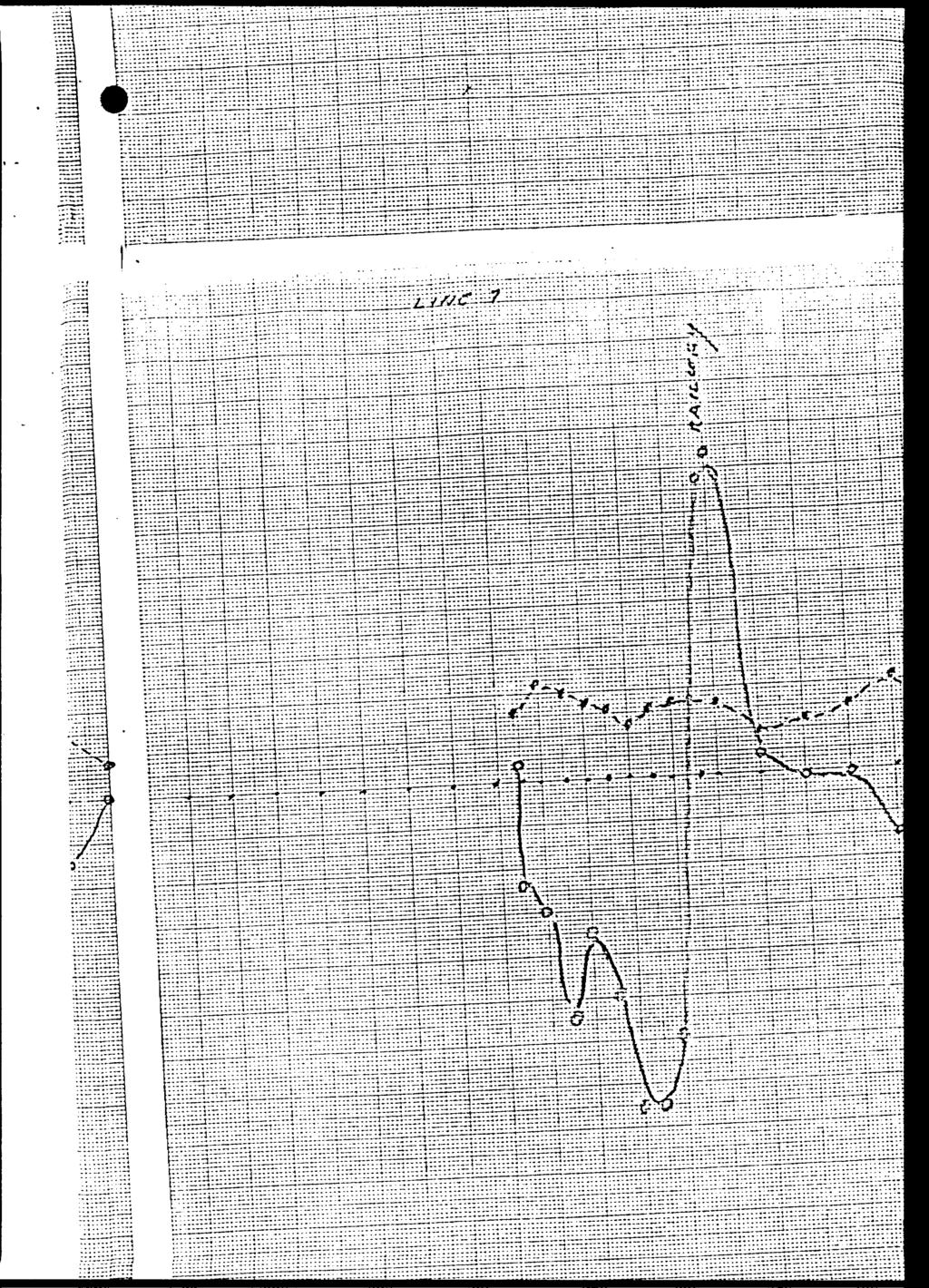
1 42A81NE LEBEL 0 10 REPORT FOLLOWING AN ELECTROMAGNETIC SURVEY ON MINING CLAIM, L-^050g. LEBEL TWP., LARDER LAKE MIN. DIV. CLAIM IS IMMEDIATELY EAST OF THE TOWN OF KIRKLAND LAKE. ROCK TYPES ARE MADE UP OF GREYWAKE TUFFS AND PORPHRYTIC LENSES. THERE IS A MAJOR FAULT ZONE CALLED THE MURDOCH CREEK FAULT AND SEVERAL FISSURE TYPE VEINS THAT FOLLOW NARROW ZONES OF SHEARING. THESE NARROW SHEAR ZONES ARE WHAT WE DEFINE AS BREAKS ALONG THE KIRKLAND LAKE ORE ZONE. INSTRUMENT USED WAS A MODEL GEONICS EM.1.6 USING SIGNALS FROM A PRIMARY FIELD. IN THIS CASE GUTTLER MAINE AN OUT OF PHASE QUADRATURE READING 4f'-^Cf IS MEASURED AGAINST AN IN-PHASE INCLQMETER *?-150#. A NEW BREAK FOUND BY DRILLING GAVE A POSITIVE CONDUCTOR. HOLES HAVE BEEN SPOTTED AND A DRILL PROGRAM IS UNDERWAY. C?., M. LABINE. RECEIVED MAY MWING LANDS SECTION
2 RepoijL.bn geophysical survey on claim Lebel Twp. Oualifications:30 years field experience. There appears to be a break going W. to E. diagonally across the railway line. If, correct this would place the main break, on line and not offset some 400 ft. further N. as it had been previously suggested. The veins N. where the break was to have been displaced lack the minerals kolybdenite and graphite, associated v.dth the main break. Instead the vein system though it makes ore grade is prononced by a chloride zone and Hematite. It appears the main break continues it's course and cuts all other fault systems. A situation similar to this one exist on the Tegren claims further W. Here the strong Amikogami fault was to have displaced the main break some 600 feet;drifting undergroudnd has shown the main break to cut all other fault zones. Recommendations: Following an indepedant consultant report on this theory a hole will be drilled to test this possibility. I strongly feel the government should get involved by paying part of the cost of a drill hole since this report conflict's the earlier reports written by this government on the structural controls of the Kirkland Lake main fault zone. \
3 Geophysical survey mining claim L Location-immediately E. of the old Toburn mine situated within residential limits of the town of Kirkland Lake. The field work was done by M. Labine, 135 Pollock St., Kirkland Lake, Ontario. There appears to be r break going W. To E. diagonally which crosses the railway line. This suggest the main break in Kirkland may follow on strike and cut all older formations. It was previously thought that the number 3 vein was the faulted extension of this major fault zone which carried almost all the gold in the Kirkland Cant&o, The veins N. carried the minerals Hematite and chloride whereas LL a new break located by drifting carried the minerals molybdenite, and graphite and myolonite which are commonly associated with the main break. The geophysical response along the new break indicate the possibility of the Kirkland break cutting through the Murdock Creek Fault.
4 Hi O; rv. o
5 i a 01 I'fi'^fJf SCAit / vv n f t*t 7*
6 /r// -..Vv" f, i li, l i.., f- W" -
7

8 -2 * 32. Z J2U -J"7 -I t C.- S^iL ^.. "S ^i::-::-::::r:l:l " :~ "" :" - ' r; -l....^... r: r :,. r...^ *.,....,.. ^..,.. rrrrrr: :^J: : :::: : \ : J: - :;:" ::? -- I : '" T l;--^i-"-t^i''; ;:^r,: : ~; ;": ~ - litx/frl-jt: vv... ::::.4 :::.:...J.:.'. :.!~' :.;.:L:::-': :! : -::".;.'ll:'.:'":l :.--':: :. :.'" :--'. : : " " ' - - "- ", :..., ;:;;-::u: -

9 3XZ- H^::nn4^^^ ,-^~"' - - Jl'" J'--^J^ ^SfJuSi&^it^i n^jgyfgffii^h """" """ iiliilill

10

11 :: iiiib!^ r.- --fc-. -~.. t~..1.1"..~. fu ^-. * *,..,.,..f.-,..-.-.,......*...

12

13 t::: LitiiilH;-:: : UT. ^ n L-iirii r...t.-...-"...:.. ir..,.. t... *..-..., ^---i~i.'tt2--;ri"."r:i,.r.2i;.;ic*i-ii2". ^2i*Tt:r*;:it:.r;rcT:~,"z.i2^"-Z:.--; ;; i ""li* *----;-~ -j '-". ;'7t;^;;;;, *--* ~.... ^.-.,.-...., *-^-^* ,, ;-r r 21 * :.u::"'^i":;":i:- ::^uz-:':":' "","-U-:':""T ": * *^U22Mt' r I22r*221".11-2^r22-.*I.ir.III*-..-* _,-.,I2... II-.TT,,--,,-..-"I - :;:."::;:: r:,-:;;r::;.:::::; ^::;;;r-"*ii:n^i:;l::m-l:i:r^^zimi: ;!IJ^lliHHilHI^^Hf:i^H :::::J::::;::::i:::::::::::::-;r:::: liiiifiliii

14
15

16 ::t:::::;:::;: r ^ HirijETrrfiHJff:-

17 i ".rr"" j~mrt-,rij-t ri :::K-"?tZ-ir*iir:i:tt-in;'.--*-i---*"""**"*"""*~":-t*:i:'-t"z"*:ittt'"-"--i] Hi^^i3HiHiii4HHHHfHin;:iUs^^^-L^i:i;k;uiiifi:^

18 Morrisette Tp. (fv \4*I2II /49I2IO ^TlMS r.-r. is^m fhs; / S L 76643, L 75643
19 42A0INE8e LEBEL 900 TO BE ATTACHED AS AN APPENDIX TO TECHNICAL REPORT FACTS SHOWN HERE NEED NOT BE REPEATED IN REPORT TECHNICAL REPORT MUST CONTAIN INTERPRETATION, CONCLUSIONS RECEIVER Flfiij A ra r l A une *rs.*..^i. ** *-ANP5 SECTION Type of Survey(s). Township or Area. L/. Claim HnlHer(s) j 1/0Si/) C MINING CLAIMS TRAVERSED Lilt numerically Survey nnmpany Aft Author of Report /^ Address Covering Dates of Survey^s Total Miles of Line Cut_2. s /^^'? /a (linecutting to^jfice),/.ss. ^ Z - i*tv**ifft (number) SPECIAL PROVISIONS CREDITS REQUESTED ENTER 40 days (includes line cutting) for first survey. ENTER 20 days for each additional survey using same grid. Geophysical Electromagnetic. Magnetometer^-. Radiometric Geochemical. DAYS per claim AIRBORNE CREDITS (Special proviilon crediti doptffapply to airborne lurveyi) Magnetometer Electromagneticx-S^ Radiometric (enter da^rper claim) DATE:., 2 rf SIGNATURE: 'Author of Report or Agent Res. GeoL.. Qualifications. Previous Surveys File No. Type Date Claim Holder TOTAL CLAIMS.
20 ?' fc- rt- 13- * L i s ar ( lt \ ii 'A ^o t. ; ^. * /i \ "x. Xj " ^ f 33- ;! 3 3" I" -4 Niitnhpr nf Stations '-^ more GROUND SURVEYS If -..t 3" ^J 3 O Crt E < rt "en rt 0 *? O.? ^ o 3' ST rt S - 3 g o; CT S- o fi9 *"J * *' 2. o ^ 3 ^** rt QfQ *r1 A S "* X O- w ^i S' 3 ^) *S ^ rv Xj ^ ^v 5 ^P 2. i 1. C rs ( S ( 1 1! rt ormq - [t 13 "l -I U Z Ch s '.^. i 3 -HK i" n j ( L S i i' n '1 Off timp D JJO *1^ *TJ *" rt M ^ Ji J2 * Z g v; ^ o o 3 5" l i D 5 s2 -^! D *^ ( T INDUCED POLARIZATION RESISTIVITY GRAVITY ELECTROMAGNETIC MAGNETIC ri 1 t *i J? y \ ^?!? Z.. J*- ( T 1 ffi en Tnetmmpnt 5 rt ( T ( -* r 1 " Parameters On time 1 S rt i r*?! 2 s- 2 s -^- 3 C Method Time Domain i i5" r-* S) l S- f -ii" : i MM* 3 yi rt- " l M j-~"~7 " Base Station location and vah Base Station check-in interval Diurnal correction method Accuracy Scale constant f-*- o" 3 ST rt 3 O. O* s r* o" : 2 i i s a. T N3! n ^- ' f a 3 -^. jrts Paramptprs mpasiired tc* c, ^ ^ ^ CJ V X X,\ Xj \ ^ 5* o *j c I -1^ ^ ^f C^ B1 ~~ \ S.A ^ r O if -t. i ~-. ^ "J v \ ^s? D.\ 3 \ ^ \ rt Q. X "t T) 3 p^" X rt x *i a t D rx rt o (-t- ^ cr 03 o ^ ^ -\ Uj i' ^^ E3 ^- D 1 2L 5" rt V "x* *~N ^\t ^ J s^ ^} V. *N nn. V a r: U Qi ^ ij ^- 5' t 3r-*- "x^\ *SI rh v 4T \t Jy X V ST O c-t K w*fr H 3 a s i *

21 Morrisette Tp. (M.374) THF TOWNSHIP LEBEL Garni Lake 54GS5Z E. 5446Z6 l V L OK6 53 ' 6\62 ' DISTRICT OF TIMISKAMING LARDER LAKE MINING DIVISION SCALE: 1-INCH 40 CHAINS O Connell ft Lake 4912 I2~ \49I2II i l tm-j t V ^2377 \6636 '6637 l 4 l) B ft 53X042 DISPOSITION OF CROWN LANDS PATENT, SURFACE AND MINING RIGHTS t ", SURFACE RIGHTS ONLY ^ ", MINING RIGHTS ONLY 9 LEASE, SURFACE AND MINING RIGHTS.. B ", SURFACE RIGHTS ONLY. H ", MINING RIGHTS ONLY Q LICENCE OF OCCUPATION.. T , Crystal [ /"\ ROADS IMPROVED ROADS KING'S HIGHWAYS RAILWAYS POWER LINES MARSH OR MUSKEG MINES CANCELLFD SURFACE RIGHTS MINING RIGHTS * C S. R M.R NOTES L l L I ' l surface rights reservation along the shores of all lakes and rivers. Areas withdrawn from staking under Section 43 of the Mining Act t R.s ). Ordtr No. File Date Disposition /11/69 S.R l ^419460! Parsons Lake l i ' X- l '' ' ' l X ~! -J -]- -.A -j (o L- l L i L. l LA l n? l l f J ^37 t-^ 52214^ Gravel F ile Grovel File 8816 MTC Grovel PH No.513 Gravel File Grovel File Sravfll File SAND and GRAVEL 'DATE OF ISSUE FEB l d 1980 Me Mu r try Lake Boston Tp. (M.332) 4 M ' --,.-"' 5 M PLAN NO SURVEYS AND MAPPING RANCH M.359 ONTARIO MINISTRY OF NATURAL RESOURCES 42AC1NE0093 2,3221 LEBEL 200 SURVEYS AND MAPPING BRANCH

22 ii:7r::r-r-,:-:;riu Mr:;, "Ttr::.:^:.:-;:::"::"-:",-; fif^^r^^ *~ i:.^.^ - * l l 77::::::::::::::-:: ":::i:::i:::::::7:;-i:::::::i.:i:::::^.:-::::::::::::j:rr::?~77:77::::::":t '^HHMn""?^:!::::::!::""."?::"?;"?^!^:^" Ill rrizrt:::r :r^tn~-::::t::ti.t::;;: r 7:7:477;- ::;-r:7: ~TT:::;: J: TH^ ^ipi^ili* ^ :77-,-^7T J117^, ~ ^^:^::*^:l::~ :i:::::::::i::::f:g:i::::!:^ ~**'^'~*" ~~'*~*~T^*" " ---'-' " *- t* ^i-ti* --..-*- ^--..H ^ ::::::: ::;':::!::::!:.-::::: H r* T Tt-II "iir**---i-"-.i... J" li im t-t.,.,...,... :. 1 7:7:17:::' /;j / * 77T77 7:71:77: :::::-rj: :;7;::;i7t:;::r;-:: 1: ::±nir::ii::rr 7.7*7..l mm 1 :::::-1- ~~~~ ""Z"~^---~~ - 7.HH *~~ "~ l ~ ::'::::i::m-::::r::tt r* 777t7T7: 3 "" J 171^ i 7.71C ^ff-tfh ili::7trr : T-TTT-TT:: TTT - -. T ^i -. - t ,j-~. -. i}:n;inn:^;^^^~^^;:--h7i::h /^ ;^ T "L ~ "'' ~ '?~7 7t i71 7'7yrr?T:'-:~i:;^7:i:7:.777: l7r:7:::::: ih r:;"; ri : : ::r; "7:*' :."":.T"T. r " : ': " 7 ::! :": r: J7-.:... -7:77:77;; t;;;-..::;:. 7i777;:-::~i:;7:i:7:7.777:7r:7:::::;: i r:;; r : : : J!^lP^iii^iMi^ : litt"77 : - " '7'77 l; m i j" ' ~rr?tttttt" l" "T-"T7T JT" i ZZUH! II" I 't~~ l :n;;;i77-, : L: 77-7 TZTT: XTTTT.. l rn 7^. f, i ~^.:ni,'^';rt'~': ::Tn^ :^T;:H^^;^H;ViiH7;:^nF^^;:^r?rH:r^ ^.'i ^ ----""-'--- -'-'' -* :" :::: -Uiii:-i7.7i ---j-"^:.:;::-.: -~ ; rrri^h:'!:n-iir::rt.-'-,:i:':;:-i I'T: :.::fr:r~:~ ^7.1^-t: "" '1777:^ ::^'' 1^:1:7' ;- 7777' "T 7' 111-^.^77' -17~TL^ r^rrr:: ^'-j 171:1 "77: :771117:11: i;:::;: t...,. t *., : - ^, -"- 7-7:7:::::;'::::::!- 7-i,j-i7-i7.,:7:-:::::;::-::-:;-::.. TTTTTZZIT 42A01NE LEBEL 210
Assessment Report by the Canadian Nickel Co. Ltd. Magnetometer Survey. Larder Lake Mining Division Lebel Tovnship, Ontario
 32084Nwea67 2.331* LEBEL 010 Assessment Report by the Canadian Nickel Co. Ltd. Magnetometer Survey Larder Lake Mining Division Lebel Tovnship, Ontario Claims L-531657 L-531658 L-531111 Map No.: M-359,
Toronto, Ontario November 16, This report may not be reproduced, in whole or in part, without the written permission of Derry, Michener S Booth.
 13 2.1354 L ITTLE 010 GEOPHYSICAL SURVEYS, LITTLE TOWNSHIP CLAIM GROUP OB-F TIMMINS AREA PORCUPINE MINING DIVISION, ONTARIO Toronto, Ontario November 16, 1973 This report may not be reproduced, in whole
SUPPLEMENT TO MAGNETOMETER 6 ELECTROMAGNETIC SURVEY REPORT. DATED NOVEMBER l, 1973 CIGLEN INVESTMENTS LIMITED CLAIMS GROUP BAD VERMILLION LAKE AREA
 ^ A R l ^ 1974 010 PROJECTS UNIT SUPPLEMENT TO MAGNETOMETER 6 ELECTROMAGNETIC SURVEY REPORT DATED NOVEMBER l, 1973 CIGLEN INVESTMENTS LIMITED CLAIMS GROUP BAD VERMILLION LAKE AREA DISTRICT OF RAINY RIVER
Newmont Exploration of Canada Limited Box 105 Commerce Court West, Toronto, Ontario MSL 1E3
 41PI5NE8341 3.3338 CAIRO 010 GEOPHYSICAL SURVEY REPORT MAGNETOMETER SURVEY CAIRO PROJECT CAIRO TOWNSHIP - NTS: 41 P/15 by Newmont Exploration of Canada Limited Box 105 Commerce Court West, Toronto, Ontario
33) Z SKEAD
 Z SKEAD") 33)04860396 Z. 1700 SKEAD 010 i j R. A. MACGREGOR, P.ENG. PAGE NO. l In t r odu c t ion Report on Magnetometer and VLF-EM Survey Part of Lots l to 6, Concessions 5 and 6 f Skead Township, Ontario - Linecutting,
33)04860396 Z. 1700 SKEAD 010 i j R. A. MACGREGOR, P.ENG. PAGE NO. l In t r odu c t ion Report on Magnetometer and VLF-EM Survey Part of Lots l to 6, Concessions 5 and 6 f Skead Township, Ontario - Linecutting,
t y RECEIVED This report is concerned with the results of the electromagnetic survey as applied to the following claims: l K to K
 t y 53F*4NWei37 2.1853 HERONRY LAKE 010 HUDSON BAY EXPLORATION AND DEVELOPMENT COMPANY LIMITED ELECTROMAGNETIC SURVEY OF GROUP "N" EAGLE PROJECT - KAKAGI BLOCK KENORA MINING DIVISION - ONTARIO RECEIVED
r ffj Ronald C. Wells, BSc. Lacana Mining Corporation LACANA CLAIMS GAUTMER TOWNSMP GEOPHYSICAL REPORT OCT LARDER LAKE MINING DIVISION
 a- 32D04NWei39 2.3507 GAUTHIER 010 GEOPHYSICAL REPORT LACANA CLAIMS GAUTMER TOWNSMP LARDER LAKE MINING DIVISION RECEIVED OCT171980 MINING UNDS SECTION Author: Ronald C. Wells, BSc. Lacana Mining Corporation
SELCO EXPLORATION COMPANY LIMITED
 --..-..-...-.....l.iibibiiiiiiiiiiiiiii II III S2J16NW9001 52J16NW0014A1 PASHKOKOGAM LAKE 0 10 SELCO EXPLORATION COMPANY LIMITED GEOPHYSICAL REPORT CLAIMS 200696 TO 200707 PATRICIA MINING DIVISION August
Project # Toronto, Canada. J. L. Wright June, 1978 WAGKICH LAKE PROPERTY REPORT ON GEOPHYSICAL SURVEYS SUMMER 1977
 31Me4SWa039 2.2725 S TRATHCONA 010 WAGKICH LAKE PROPERTY REPORT ON GEOPHYSICAL SURVEYS SUMMER 1977 Project #133.1 Toronto, Canada J. L. Wright June, 1978 INTRODUCTION A magnetometer and horizontal loop
Timmins, Ontario. Bryce Murdoch Geologist. October 1979 REPORT ON A GEOLOGICAL SURVEY MATHESON CLAIMS WARDEN-2 PROJECT
 2.3106 WARDEN 010 REPORT ON A GEOLOGICAL SURVEY MATHESON CLAIMS WARDEN-2 PROJECT 839-14 AMAX MINERALS EXPLORATION Timmins, Ontario Timmins, Ontario October 1979 Bryce Murdoch Geologist SUMMARY Four claims
ZENMAC METAi, MINES LIMITED. SCHHKIBEK, ONTnHlO. PURVEY OK THE NI'COPOR PROPERTY
 63.2625 PAYS PLAT LAKE 010 ZENMAC METAi, MINES LIMITED SCHHKIBEK, ONTnHlO. PURVEY OK THE NI'COPOR PROPERTY IS'iRODUCTIQM The property, about 6 miles north of Schreiber, has been held by various people
MINING CLAIMS t A
 2L**NE* 2.2*38 METCALFE LAKE OO CESCRIPTION OF WORK PERFORMED ON MINING CLAIMS 3. 3. 32. 327t 3260. A 326 3 Located and cleaned out three previously excavated rock trenches* Trenches measured 00 feet,
y^ cjc-o-4-o^v*, O cx S oj X o 5 \ J * X -*-oj *O *^l vxyvx^v^s- ' o r^. OO*JLc 52N07SVMW26 OPO2-10S SKINNER
 5N07SVMW6 OPO-10S SKINNER i\ r^. OO*JLc ' K. vxyvx^v^s- \ J *^l * X -*-J *O O cx l X 5 S J y^ cjc--4-^v*, I. c/ ^ f hi *r M, fu ^ r^ vp p P v ^ r?ur' f R Hi?f r^lrtf r H ^ i? f * r j pir f ^t-? ^ f ^ f,
RECEIVED JUL28. AM t: /5 n OM MINING LANDS SECTION. MINING ojy: MAY, 1988 GEOPHYSICAL REPORT VLF-EM SURVEY OBRADOVICH CLAIMS
 2.11443 GUIBORD 010 GEOPHYSICAL REPORT VLF-EM SURVEY OBRADOVICH CLAIMS GUIBORD TOWNSHIP LARDER LAKE MINING DIVISION DISTRICT OF COCHRANE, ONTARIO RECEIVED JUL28 MINING LANDS SECTION MINING ojy: fju,l 2
RECEIVED. May ^6 Kirkland Lake, Ont MINING LANDS SECTION ASSESSMENT REPORT MAGNETOMETER SURVEY CLAIM //842970
 42Aeiseeeie a.9ts4 TECK 010 ASSESSMENT REPORT MAGNETOMETER SURVEY CLAIM //842970 TWP. of TECK LARDER LAKE MINING DIVISION FOR LAC MINERALS (MACAS3A DIVISION) by JOMI MINERALS ft EXPEDITING LTD. May 15
3'^760. /{//o RED LAKE MINING DIVISION o O 2f fa//...
 010 3'^760 fr^. GEOLOGICAL ASSESSMENT REPORT lvl g f ; ; a ^, r PAW CREEK 1-76 ^ fc ^'^ /{//o RED LAKE MINING DIVISION o O 2f fa//... NTS 53C-13, D-16 INTRODUCTION A detailed geological survey at a scale
Report of Gridding and Magnetic Surveys. On the. Munro Property. Munro and Beatty Townships, Ontario. Larder Lake Mining Division
 Report of Gridding and Magnetic Surveys On the Munro Property Munro and Beatty Townships, Ontario Larder Lake Mining Division Claims: 39 4244 For Big Red Diamond Corporation October 3, 2 Timmins, Ontario
REPORT OF THE MAGNETOMETER SURVEY. GROUP l, GRID A - BEE LAKE AREA CLAIM MAP M2194, RICKABY LAKE KENORA MINING DIVISION, ONTARIO
 S2L1&NW0813 3.1334 EAGLE LAKE 010 3 K EC El V ED REPORT OF THE MAGNETOMETER SURVEY GROUP l, GRID A - BEE LAKE AREA CLAIM MAP M2194, RICKABY LAKE KENORA MINING DIVISION, ONTARIO by SELCO MINING CORPORATION
THE ALGOMA STEEL CORPORATION, LIMITED GEOPHYSICAL REPORT GEONICS V.L.F. E.M.-16 ANOMALY #15 - CHABANEL TOWNSHIP SAULT STE. MARIE MINING DIVISION
 42CC2SE8880 ee^sat CHABANEL 010 THE ALGOMA STEEL CORPORATION, LIMITED RECEIVED SEP-41981 MINING LANDS SECTION GEOPHYSICAL REPORT GEONICS V.L.F. E.M.-16 ANOMALY #15 - CHABANEL TOWNSHIP SAULT STE. MARIE
RECEIVED. .* : - Al IR l MINING LANDS SECTION. Deborah McCombe Abltlbi-Price Inc. Mineral Resources Division July 28, 1981
 010 RECEIVED.* : - Al IR l 21981 MINING LANDS SECTIN REPRT N MAX-MIN II AND MAGNETIC SURVEY by ABITIBI-PRICE INC. MINERAL RESURCES DIVISIN LUCAS TWP. NTARI CLAIMS Deborah McCombe Abltlbi-Price Inc. Mineral
Report on The Magnetic Survey. Property of Loydex Resources Inc. Keigat Lake Area. Red Lake Mining Division
 010 Report on The Magnetic Survey On The Property of Loydex Resources Inc. SANDY POINT PROJECT Keigat Lake Area District of Kenora, Patricia Portion Red Lake Mining Division N.T.S. 52-N-8 Whitby, Ontario
We are committed to providing accessible customer service. If you need accessible formats or communications supports, please contact us.
 We are committed to providing accessible customer service f you need accessible formats or communications supports please contact us Nous tenons à améliorer l accessibilité des services à la clientèle
REPORT ON EXPLORATION DURING 1980 FOR THE LEBEL CLAIM GROUP LEBEL TOWNSHIP, ONTARIO
 32De4NW8248 63.3933 LEBEL 010 REPORT ON EXPLORATION DURING 1980 FOR THE LEBEL CLAIM GROUP LEBEL TOWNSHIP, ONTARIO LACANA MINING CORPORATION November, 1980 32D*4NWea48 63.3933 LEBEL 010C TABLE OF CONTENTS
magnetic and electromagnetic survey carried out to locate on the ground an aeromagnetic zone and associated In-put anomalies indi
 42IICWMW 63.2293 FLINCH LAKE O1O 6 3- Z* The President and Directors, Consolidated Manitoba Mines Limited. 114 East 90th Street. New York City 10028. New York. U. S. A. Gentlemen: This report describes
DIAMOND DRI 42A12SW BANNOCKBURN 010. CLAIM No, HOLE No, FOOTAGE DATE NOTE. TOWNSHIP: Bannockburn REPORT No,:
 DIAMOND DRI 42A12SW0336 16 BANNOCKBURN 010 TOWNSHIP: Bannockburn REPORT No,: WORK PERFORMED BY: Petromet Resources Ltd. CLAIM No, HOLE No, FOOTAGE DATE NOTE L 571405 84-1 84-2 310 224 Dec/84 Dec/84 (D
Magnetic Field and VLF Surveys on the Shining Tree Property. Claims: , , , , , , , ,
 December 29, 2014 NTS: 041P11 Magnetic Field and VLF Surveys on the Shining Tree Property Claims: 1203361, 4251801, 4251803, 4251805, 4263067, 4263068, 4270940, 4270436, 4276740 Churchill and Asquith Townships
XRAL X-RAY Bharti Engineering Associates Inc Lasalle Blvd. P O Box 2336 Sudbury (M P3A4S8. DATE SUBMITTED 9-Aug-89
 XRAL X-RAY 1885 LESLIE S TEL: (416)445 41113SE9429 2.12731 ULSTER 010 C ERT X F X O A.T E TO: BHARTI ENGINEERING ASSOCIATES INC. ATTN: HAROLD J. TRACANELLI 1009 LASALLE BLVD P.O. BOX 2336 SUDBURY, ONTARIO
42A88SE9en 2.36H2 BENOIT 010 MINING IMW* **-' r REPORT ON GEOPHYSICAL SURVEYS ON PROPERTY OF GOLIATH MINES LTD. BENOIT TOVINSHIP, ONTARIO L J
 42A88SE9en 2.36H2 BENOIT 010 MINING IMW* **-' r REPORT ON GEOPHYSICAL SURVEYS ON PROPERTY OF GOLIATH MINES LTD. BENOIT TOVINSHIP, ONTARIO ~l L J PROSPECTING GEOPHYSICS LTD. REPORT GEOPHYSICAL SURVEYS ON
Report of Geology Vimy Ridge Project Four Mining Claims, N^ of Lot 6, Concession III Bowman Township Ontario
 42A88NWai04 2.5281 BOWMAN 010 Report of Geology Vimy Ridge Project Four Mining Claims, N^ of Lot 6, Concession III Bowman Township Ontario Asarco Exploration Company of Canada Limited Alex S. Horvath December
John A. Wakeford Noranda Exploration Co., Ltd, November 4, 1980 rinnnins, Ontario
 42CC1NEfc4e9 801101 ECHUM 010 " ' i-^y&sg?' '.. -.r. K;VW\\:.!^-*.]-^--'^-r-r^Pj^Q..-. ;,: v 1,;-'-,..- ^^-^^^^ysr-r^ijjfiv^jj. v -." ". '. ' "i - '' '. '':.;': s.'.ilv'., p...--'*l r-j@tw IP ^vt'.'v*:-^
41016SE0035 Z GENOA 010
 41016SE0035 Z. 1058 GENOA 010 3.106? GEOLOGICAL SURVEY GENOA TOWNSHIP PROPERTY RUSH LAKE EXPLORATIONS LIMITED SUMMARY The following report describes the results of a geological ^survey conducted over the
Post. Claim E.O D.D.Hole \ L ength 243' Bearing N.52 U W, Dip 45 0 AXT core BIJOU MINFS LIMITED. l" to 100' 31C15NW PALMERSTON 010
 #1 Post Claim E.O. 460392 D.D.Hole \ L ength 243' Bearing N.52 U W, Dip 45 0 AXT core BIJOU MINFS LIMITED l" to 100' September 22, 1977 J. P. Jewell 31C15NW0019 74 PALMERSTON 010 DIAMOND DRILL RECORD PROPERTY
RECEIVED MOV 12 IBM FINING LANDS SECTION. Lacana Mining Corporation Kirkland Lake, Ontario October Author: Ronald C. Wells GEOPHYSICAL REPORT
 3 42A83NW0814 2.4383 MCARTHUR 010 GEOPHYSICAL REPORT LACANA CLAIM GROUP MC ARTHUR TOWNSHIP PROCUPINE MINING DIVISION RECEIVED MOV 12 IBM FINING LANDS SECTION Author: Ronald C. Wells Lacana Mining Corporation
November 7, 19H4 David W. Constable, H.BSc., F.G.A.C. NTS -12A/.1 GEOPHYSICAL REPORT CLAIM L F. T. O'CONNOR PROPERTY LEBEL TOWNSHIP
 NTS -12A/.1 42A81NEee82 Z. 754 LEBEL 1 GEOPHYSICAL REPORT CLAIM L-5287 F. T. O'CONNOR PROPERTY LEBEL TOWNSHIP LARDER LAKE MINING DIVISION ONTARIO November 7, 19H4 David W. Constable, H.BSc., F.G.A.C. r.nt-l
REPORT OF MAGNETOMETER AND VLF-EM SURVEY Claim K60342S Tabor Lake Area Kenora Mining
 REPORT OF MAGNETOMETER AND VLF-EM SURVEY Claim K60342S Tabor Lake Area Kenora Mining INTRODUCTION SZFWSHBS^ 2. 1528 TABOR LAKE 0 10 The claim is located about 1/2 mile east of the Sandy Point Road 4 1/2
JOL 2 l 1962 sicnon MNIM
 32D*5NE*423 2.4957 HARKER 010 RECEIVED JOL 2 l 1962 sicnon MNIM REPORT ON MAGNETOMETER SURVEY KURD CLAIMS HARKER TOWNSHIP ONTARIO July 12, 1982. G.G.Kasner P.O. Box 1053 Kirkland Lake, Ont. 010C TABLE
We are committed to providing accessible customer service. If you need accessible formats or communications supports, please contact us.
 We are committed to providing accessible customer service. If you need accessible formats or communications supports, please contact us. Nous tenons à améliorer l accessibilité des services à la clientèle.
RECEIVED JUL O MINING LANDS SECTION REPORT ON GROUND V.L.F. SURVEYS SEWELL 1-81 NORTHERN ONTARIO BRIAN GROVES TIMMINS, ONTARIO JUNE 21, 1984
 42Ae4KIWM26 2.6923 SEWELL 010 REPORT ON GROUND V.L.F. SURVEYS SEWELL 1-81 SEWELL TOWNSHIP NORTHERN ONTARIO BRIAN GROVES NORANDA EXPLORATION CO. LTD. TIMMINS, ONTARIO JUNE 21, 1984 RECEIVED JUL O 6 1984
WAONEK-MILLS JPHVSiCAL SURVEYS
 xxxxxx L. i* ^- O PHONE HO, C - 7526 XXXXXXX) WAONEK-MILLS JPHVSiCAL SURVEYS XXXXXAAA SUITE 401, 62 RICHMOND ST. WEST 15 MEREDITH. IEREDITH. C RESCENT TOR.ONTO. TORONTO, CANADA till6ne0082 0815C1 SCHOLES
AUG 12. Report on Radon Gas Survey Laurencin Property Cardiff Township, Ontario. D. M. Hendrick, P. En Chief Geologist, Ex August 8, 1975
 31E16NE0163 2.1884 CARDIFF 010 AUG 12 PROJECTS UNIT KERR ADDISON MINES LIMITED Report on Radon Gas Survey Laurencin Property Cardiff Township, Ontario D. M. Hendrick, P. En Chief Geologist, Ex August 8,
~,. :'lr. H ~ j. l' ", ...,~l. 0 '" ~ bl '!; 1'1. :<! f'~.., I,," r: t,... r':l G. t r,. 1'1 [<, ."" f'" 1n. t.1 ~- n I'>' 1:1 , I. <1 ~'..
 ,, 'l t (.) :;,/.I I n ri' ' r l ' rt ( n :' (I : d! n t, :?rj I),.. fl.),. f!..,,., til, ID f-i... j I. 't' r' t II!:t () (l r El,, (fl lj J4 ([) f., () :. -,,.,.I :i l:'!, :I J.A.. t,.. p, - ' I I I
2. 3 ST 73. wmlno. November 14, 1980 Don E. Tremblay TECK 51. N.T.S: 42-A-l PROJECT # 86 TEXASGULF CANADA LTD. GEOPHYSICAL REPORT
 2. 3 ST 73 42A0INE0200 2.3573 TECK 010 TEXASGULF CANADA LTD. GEOPHYSICAL REPORT ON wmlno TECK 51 N.T.S: 42-A-l PROJECT # 86 November 14, 1980 Don E. Tremblay TEXASGULF CANADA LTD. GEOPHYSICAL REPORT ON
RECEIVED. tn r-"t."' Magnetometer and VLF-EM Surveys Assessment Report. South Cobalt Silver Project South Lorrain Twp. Mhakari Gold Corp.
 RECEVED APR 1 5 111 OOSC!C! AESSMET tn r-"t. Magnetometer and VLF-EM Surveys Assessment Report South Cobalt Silver Project South Lorrain Twp. Mhakari Gold Corp. March 211 TS 31 M/3-4 Meegwich Consultants
RECEIVED JUL MINING LANDS SECTIOM KATRINE TOWNSHIP, ONTARIO LARDER LAKE MINING DIVISION NTS 32 D A REPORT ON
 3aDMSEM4S S.9349 KATRINE 010 GRID KA 8 KATRINE TOWNSHIP, ONTARIO LARDER LAKE MINING DIVISION NTS 32 D A REPORT ON MAGNETIC SURVEY RECEIVED JUL 11 1986 MINING LANDS SECTIOM A. JAMES WALKER P.Eng. JUNE 18,
Norlex Mines Property. Whitefish Bay Area, Kenora District. The property of Norlex Mines under option to Canadian Javelin
 52E09SW0025 63.2231 WHITEFISH BAY AND MA Norlex Mines Property D: KENORA 010 D. SEP 14-1967 RECEIPT No. MINING DIVISION Whitefish Bay Area, Kenora District. '; Introduction The property of Norlex Mines
OEOMAQNETIC SURVEI QUIBORD TOWNSHIP GROUP #2 HOLLINGER CONSOLIDATED GOLD MINES, LTD.
 OEOMAQNETIC SURVEI QUIBORD TOWNSHIP GROUP #2 HOLLINGER CONSOLIDATED GOLD MINES, LTD. 42Ae9SE0268 63.1502 GUIBORD (711(71 Introduction During the period January 5 - February 26, 1965, a magnetometer survey
Nickel Division - Sudbury Operations
 * *-.. FALCONBRIDGE NICKEL MINES LIMITED Nickel Division - Sudbury Operations Falconbridge, Ontario 002261 GRAHAM 010 GEOLOGY OF TllE NORTH QUARTER OP LOT 2, CON. IV, GRAHAM TOWNSHIP, DISTRICT OP SUDBURY,
o C *$ go ! b», S AT? g (i * ^ fc fa fa U - S 8 += C fl o.2h 2 fl 'fl O ' 0> fl l-h cvo *, &! 5 a o3 a; O g 02 QJ 01 fls g! r«'-fl O fl s- ccco
 > p >>>> ft^. 2 Tble f Generl rdnes. t^-t - +«0 -P k*ph? -- i t t i S i-h l -H i-h -d. *- e Stf H2 t s - ^ d - 'Ct? "fi p= + V t r & ^ C d Si d n. M. s - W ^ m» H ft ^.2. S'Sll-pl e Cl h /~v S s, -P s'l
MAGNETIC SURVEY REPORT. on the O'BRIEN CLAIM GROUP. Deloro Township Porcupine Mining Division, Ontario. for PAMOUR PORCUPINE MINES LIMITED
 42A06NE0456 2.7439 DELORO 010 MAGNETIC SURVEY REPORT on the O'BRIEN CLAIM GROUP Deloro Township Porcupine Mining Division, Ontario as se C/J 1* m O for PAMOUR PORCUPINE MINES LIMITED by Kian A. Jensen,
RED LAKE MINING DIVISION. DISTRICT of KENORA LOUIS C. CHASTKO. for COCHENOUR WILLANS GOLD MINES, LIMITED. March, 1976
 S2N82SE9938 3.2874 BATEMAN 0 10 RECEIVED REPORT ON APR 5 1976 PROJECTS UNIT GEOPHYSICAL INVESTIGATIONS Of THE EAST BAY CLAIM GROUP BATEMAN TOWNSHIP, PLAN M2139 RED LAKE MINING DIVISION DISTRICT of KENORA
:^^^^.^:*^.-f.^ r--", y.;-., - :^--,.,:,-;. ^;^u;;:-4:-;:-c?\'rfe *.V. V '^-t?"' :"^4^'A^'-*""^ ::--^-*^ii^i' :'^'^
 43C88SW0176 9939 JACOBSON i ;^*X ' y-f-'v' - * - :- " v-v-vj- "'-, p,v- *.,-... ''- i,. --: ^j v i,:^ v.- ' *,..-.- x, S'J~ f;" V J *J ' :'i? "'. 'f ' -'"c,- ; i -- - -?-.-'.f ' -' ' -. '.f-,-,.~.~ -Ji-'.'-:
December 6th I960. President and Directors, Chipman Lake Mines Ltd. 25 King Street West, Toronto.
 OFFICE: EM, 3-3933 RES.: HU. 1-1265 "' Mfc 42A85NE0127 63.1089 GODFREY 010. D. President and Directors, Chipman Lake Mines Ltd. 25 King Street West, Toronto. December 6th I960 REPORT ON GEOPHYSICAL SURVEY
John C. Grant sias Exploration Limited. Timmins, Ontario June, 1983 REPORT O N MAGNETOMETER SURVEY CHURCHILL TOWNSHIP
 41P11NE8498 2.5630 CHURCHILL 010 REPORT O N MAGNETOMETER SURVEY CHURCHILL TOWNSHIP PORCUPINE MINING DIVISION NORTHEASTERN ONTARIO for GUILLAUME LEBLANC Timmins, Ontario June, 1983 John C. Grant sias Exploration
r.- L A c, i*-...-' &V set T.ANTHONY GROUP k COUTURE LAKE GROUP* STURGEON LAKE AREA ONTARIO COPCONDA-YORK RESOURCES INC. GEOPHYSICAL SURVEYS ON THE
 52J02SE8687 63.4234 SQUAW LAKE 010 r.- b; i*-...-' &V COPCONDA-YORK RESOURCES INC. GEOPHYSICAL SURVEYS ON THE T.ANTHONY GROUP k COUTURE LAKE GROUP* STURGEON LAKE AREA ONTARIO December 30, 1983. L A c,
MERCIER KXPLORATIONS LTD. FARADAY TOWNSHIP URANIUM PROSPECT. \ fi ONTARIO HARPER CONSULTING SERVICES INC, FEBRUARY 15, 1980
 * 31F04SW9521 2.3223 FARADAY 010 MERCIER KXPLORATIONS LTD. \ fi FARADAY TOWNSHIP URANIUM PROSPECT TOTAL FIELD MAGNETIC fc RADIOMETRIC (LAKE ONLY) SURVEYS ONTARIO FEBRUARY 15, 1980 HARPER CONSULTING SERVICES
REPORT ON GEOPHYSICAL SURVEYS DOME EXPLORATION (CANADA) LTD* TOIBL1N50N
 LTD* TOIBL1N50N") : PROSPECTING GEOPHYSICS LTD. 42H05SW8058 Z.2367 NEWMAN 010 REPORT ON GEOPHYSICAL SURVEYS DOME EXPLORATION (CANADA) LTD* TOIBL1N50N TtfPS.. DMT INTRODUCTION ; v. V ':\ - i '. ' \.'-K, Electromagnetic and
: PROSPECTING GEOPHYSICS LTD. 42H05SW8058 Z.2367 NEWMAN 010 REPORT ON GEOPHYSICAL SURVEYS DOME EXPLORATION (CANADA) LTD* TOIBL1N50N TtfPS.. DMT INTRODUCTION ; v. V ':\ - i '. ' \.'-K, Electromagnetic and
We are committed to providing accessible customer service. If you need accessible formats or communications supports, please contact us.
 We are committed to providing accessible customer service. If you need accessible formats or communications supports, please contact us. Nous tenons à améliorer l accessibilité des services à la clientèle.
REPORT ON A GROUND MAGNETIC SURVEY OF MINEFINDERS PROPERTY PIFHER TOWNSHIP THUNDER BAY MINING DIVISION ONTARIO
 42E13SW0046 8.7249 TYROL LAKE 010 REPORT ON A GROUND MAGNETIC SURVEY OF MINEFINDERS PROPERTY PIFHER TOWNSHIP THUNDER BAY MINING DIVISION ONTARIO NTS: 42EI3 LONGITUDE: 8?o50'W LATITUDE: 49Q57N RECEIVED
V.C.Papertzian St.Joseph Explorations Ltd. Toronto, Ontario. February, 1978 REPORT ON GROUND GEOPHYSICAL SURVEY GRID #6 A.E.M.
 A T S2K15NEe024 2.2758 SLATE LAKE 010 REPORT ON GROUND GEOPHYSICAL SURVEY GRID #6 A.E.M. #5 Toronto, Ontario. February, 1978 V.C.Papertzian St.Joseph Explorations Ltd. SUMMARY A horizontal loop electromagnetic
DIAMOND DRILLING. RECORDED HOLDER: Same as Above [xx] : Other [ ] Date. Footage. Hole No. Note 804* 807' NL-87-2 NL Dec/87 Dec/87 (D (D
![DIAMOND DRILLING. RECORDED HOLDER: Same as Above [xx] : Other [ ] Date. Footage. Hole No. Note 804* 807' NL-87-2 NL Dec/87 Dec/87 (D (D](/thumbs/91/106372138.jpg "DIAMOND DRILLING. RECORDED HOLDER: Same as Above [xx] : Other [ ] Date. Footage. Hole No. Note 804* 807' NL-87-2 NL Dec/87 Dec/87 (D (D") 42 GAUTHIER 010 DIAMOND DRILLING TOWNSHIP: GAUTHIER TWP. REPORT NO: 42 WORK PERFORMED FOR: 559505 Ontario Ltd RECORDED HOLDER: Same as Above [xx] : Other [ ] Claim No. Hole No. Footage Date Note 954489
42 GAUTHIER 010 DIAMOND DRILLING TOWNSHIP: GAUTHIER TWP. REPORT NO: 42 WORK PERFORMED FOR: 559505 Ontario Ltd RECORDED HOLDER: Same as Above [xx] : Other [ ] Claim No. Hole No. Footage Date Note 954489
MAY D. R. Bell, B.Se. April, 1974 RECEIVED REPORT MAGNETOMETER AND ELECTROMAGNETIC SURVEYS OF THE FRANK PFEIFER CLAIM SHAW TOWNSHIP
 RECEIVED MAY 3 1974 PROJECTS UNIT 42Ae6NE034a 2.1473 SHAW 010 REPORT ON MAGNETOMETER AND ELECTROMAGNETIC SURVEYS OF THE FRANK PFEIFER CLAIM SHAW TOWNSHIP PORCUPINE MINING DIVISION ONTARIO D. R. Bell, B.Se.
RECEIVED MINING LANDS SECTION. a.9535 MCTAVISH. E.A. JENNINGS, H.D.Se. Thunder Bay, Ontario September GEOLOGY OF THE THUNDER BAY AMETHYST MINE
 a.9535 MCTAVISH 010 GEOLOGY OF THE THUNDER BAY AMETHYST MINE AND PRECIOUS PURPLE GEMSTOHES CLAIMS E.A. JENNINGS, H.D.Se. Thunder Bay, Ontario September 30 1985 RECEIVED MOV l o 1986 MINING LANDS SECTION
o ri fr \ jr~ ^: *^ vlj o^ f?: ** s;: 2 * i i H-: 2 ~ " ^ o ^ * n 9 C"r * ^, ' 1 ^5' , > ^ t g- S T ^ r. L o n * * S* * w 3 ** ~ 4O O.
 THE PENALTY FR MAKING A FALSE STATEMENT IN THIS REPRT AND/R CERTIFICATE IS S5. R SIX MNTHS IMPRISNMENT R BTH "D "? y. " cr TJ Xl^ " Q. rt 5' "g s r ^.. C i :? S :.. y ' : s s ^ST (X. I ^^ ^ ^ S : t ^ :
GUY THIBAULT EXPLORATION SERVICES Suite 22, Hollinger Building - P.O. Box 1670 Timmins, Ontario. P4N 7W8-(705)
") GUY THIBAULT EXPLORATION SERVICES Suite 22, Hollinger Building - P.O. Box 1670 Timmins, Ontario. P4N 7W8-(705) 264-2977 42G18SE8iei 2.10940 WILLIAMSON 010 REPORT ON A GROUND MAGNETIC AND ELECTROMAGNETIC
GUY THIBAULT EXPLORATION SERVICES Suite 22, Hollinger Building - P.O. Box 1670 Timmins, Ontario. P4N 7W8-(705) 264-2977 42G18SE8iei 2.10940 WILLIAMSON 010 REPORT ON A GROUND MAGNETIC AND ELECTROMAGNETIC
lil in i linn i in mi li linn 111"""" 111 E2BHSW8B SABAWI t MCCAUL 010
 lil in i linn i in mi li linn 111"""" 111 E2BHSW8B94 83.1-25 SABAWI t MCCAUL 010 OCTOBER 22, I960. TO FROM SUBJECT ~ MR. K. A. DAVIS, PICKERING HCTAL MINES LIMITED, TORONTO DR. R. A, MALET, ZENMAC METAL
176 5 t h Fl oo r. 337 P o ly me r Ma te ri al s
 A g la di ou s F. L. 462 E l ec tr on ic D ev el op me nt A i ng er A.W.S. 371 C. A. M. A l ex an de r 236 A d mi ni st ra ti on R. H. (M rs ) A n dr ew s P. V. 326 O p ti ca l Tr an sm is si on A p ps
RECEIVED IANOS SECTION. GEOLOGY REPORT FOR GARNET GROUP l GARNET TOWNSHIP DISTRICT OF SUDBURY RONALD C. WELLS KIRKLAND LAKE, ONTARIO
 4l009NW0e91 2.5557 GARNET 010 GEOLOGY REPORT FOR GARNET GROUP l GARNET TOWNSHIP DISTRICT OF SUDBURY RECEIVED B IANOS SECTION LACANA MINING CORPORATION MARCH 25, 1983 RONALD C. WELLS KIRKLAND LAKE, ONTARIO
31M05SE LORRAIN 010
 LATOLIR LAKE VLF SURVEY 31M05SE0003 2.4460 LORRAIN 010 The EM-16 survey program on the Latour Lake Property located in Lorrain Township, District of Temiskaming, Sudbury Mining Division has been extended
GEOPHYSICAL REPORT ON KNAPPET CLAIMS BEDIVERE LAKE AREA. TiluKDL'R BAY MINING DISTRICT ONTARIO ASARCO EXPLORATION COMPANY OP CANADA, LIMITED
 j. i fol 52B15SE0040?.1507 BEDIVERE LAKE 010 RECEIVED JUN281974 PROJECTS UNIT GEOPHYSICAL REPORT ON KNAPPET CLAIMS BEDIVERE LAKE AREA TiluKDL'R BAY MINING DISTRICT ONTARIO ASARCO EXPLORATION COMPANY OP
rhtre PAID U.S. POSTAGE Can't attend? Pass this on to a friend. Cleveland, Ohio Permit No. 799 First Class
 rhtr irt Cl.S. POSTAG PAD Cllnd, Ohi Prmit. 799 Cn't ttnd? P thi n t frind. \ ; n l *di: >.8 >,5 G *' >(n n c. if9$9$.jj V G. r.t 0 H: u ) ' r x * H > x > i M
Total Magnetic Field and VLF Surveys on the Swayze Property. Claim Swayze Township. Porcupine Mining Division
 1 January, 016 NTS: 041 O 15 Total Magnetic Field and VLF Surveys on the Swayze Property Claim 475471 Swayze Township Porcupine Mining Division 380850E, 599450N UTM Z17N NAD83 Report Prepared for: 540
NICOLA M.D King Street West, April, 1969 AMALG 1-44 MINERAL CLAIMS 1. OWNER: Dr. F. R. Burton, W. M. Sirola, P. Eng.
 REPORT ON ' MAGNETIC AND ELECTROMAGNETIC SURVEY AMALG 1-44 MINERAL CLAIMS 1. NICOLA M.D. 49'501 N - 12Oo57f W OWNER: Dr. F. R. Burton, 1506-44 King Street West, Toronto 1, Ontario. by W. M. Sirola, P.
4. Geological maps published by the Ontario Department of Mines.
 52J08NWei45 S2J08NWa6B1 SMYE 010 AMALGAMATED RARE EARTH MINES LTD. *, SAVANT LAKE PROSPECT x ONTARIO INTRODUCTION t This Is a report on a group of 28 claims control led by Amalgamated Rare Earth Mines
REPORT ON GEOLOGICAL MAPPING OF CLAIM SHAW TOWNSHIP PORCUPINE MINING DIVISION) NORTHEASTERN ONTARIO FOR LAURION GOLD INCORPORATED
 NORTHEASTERN ONTARIO FOR LAURION GOLD INCORPORATED") REPORT ON GEOLOGICAL MAPPING OF CLAIM 1180899 SHAW TOWNSHIP PORCUPINE MINING DIVISION) NORTHEASTERN ONTARIO * O Q Q fi FOR LAURION GOLD INCORPORATED Schumacher, ON November 29th, 2004 Leslie A. Tihor Tihor
REPORT ON GEOLOGICAL MAPPING OF CLAIM 1180899 SHAW TOWNSHIP PORCUPINE MINING DIVISION) NORTHEASTERN ONTARIO * O Q Q fi FOR LAURION GOLD INCORPORATED Schumacher, ON November 29th, 2004 Leslie A. Tihor Tihor
For personal use only
 ASX:LEG 10 July 2014 Fraser Range Aeromagnetic Survey Identifies Targets Seven priority targets considered prospective for nickel-copper Targets interpreted to relate to intrusive mafic/ultramafic bodies
42H88SW NEWMAN
 42H88SW0003 63.8199 NEWMAN 010 TRIPOINT MINES LIMITED, Suite 305-100 Adelaide St. West, Toronto l, Ontario. Gentlemen: Your Company recently conducted a combined magneticelectromagnetic survey over a ten
B.C. Vancouver, Sritish Columbia. Ragas Claims, Omenica M.D., A GEOPHYSICAL REPORT. A GROUKD NAGMETIC 6: ELECTRO?.IAGr\TETIC SURVEY FOR
 A GEOPHYSICAL REPORT A GROUKD NAGMETIC 6: ELECTRO?.IAGr\TETIC SURVEY Ragas Claims, Omenica M.D., B.C. FOR CATRE - 3EK JOINT VENTURE PETER E. WALCOTT & ASSOC. LIPIITED Vancouver, Sritish Columbia OCTOEEEt
June, 1982 M.W. Zang. N.T.S.: 42-A-12 Claim: P MINING LANDS SECTION KIDD CREEK MINES LTD. REPORT ON GEOPHYSICAL WORK JAMIESON TOWNSHIP
 42A12SE0189 2.4888 JAMIESON 010 KIDD CREEK MINES LTD. REPORT ON GEOPHYSICAL WORK MINING LANDS SECTION JAMIESON TOWNSHIP N.T.S.: 42-A-12 Claim: P-591258 June, 1982 M.W. Zang KIDD CREEK MINES LTD. REPORT
MODERN GEOPHYt INTRODUCTION
 MODERN GEOPHYt SUITE 5-13 ADELAIDE ST. E. TORONTO - ONTARIO 42A06SE8121 63.1009 ELDORADO 0 10 JU*Jkl.TJLA. JL JL^A^r GEOPHYSICAL SURVEYS ELECTROMAGNETIC (VERTICAL 8r HORIZONTAL) TELEPHONE: MAGNETIC EMPIRE
REPORT ON GEOLOGY DUVAN COPPER COMPANY LTD. REX LAKE PROPERTY, TORONTO.
 * 52L*7NEM36 7 63A.S55 REX LAKE 010 REPORT ON GEOLOGY DUVAN COPPER COMPANY LTD. REX LAKE PROPERTY, TORONTO. Toronto, Ontario July 28, 19^9- INTRODUCTION A party consisting of A. Kopare, engineer and P.
I-1. rei. o & A ;l{ o v(l) o t. e 6rf, \o. afl. 6rt {'il l'i. S o S S. l"l. \o a S lrh S \ S s l'l {a ra \o r' tn $ ra S \ S SG{ $ao. \ S l"l. \ (?
 o t. e 6rf, \o. afl. 6rt {'il l'i. S o S S. ll. \o a S lrh S \ S s l'l {a ra \o r' tn $ ra S \ S SG{ $ao. \ S ll. \ (?") >. 1! = * l >'r : ^, : - fr). ;1,!/!i ;(?= f: r*. fl J :!= J; J- >. Vf i - ) CJ ) ṯ,- ( r k : ( l i ( l 9 ) ( ;l fr i) rf,? l i =r, [l CB i.l.!.) -i l.l l.!. * (.1 (..i -.1.! r ).!,l l.r l ( i b i i '9,
>. 1! = * l >'r : ^, : - fr). ;1,!/!i ;(?= f: r*. fl J :!= J; J- >. Vf i - ) CJ ) ṯ,- ( r k : ( l i ( l 9 ) ( ;l fr i) rf,? l i =r, [l CB i.l.!.) -i l.l l.!. * (.1 (..i -.1.! r ).!,l l.r l ( i b i i '9,
551, on claim \ Date of Report
 Ontario initry of t,rthern Development d Mine Report ofwork or each jelow). Report cal and Name and Potal Addre of Recorded Holder Canlorm Reource Inc. 500 67 Richmond St. Wet, Toronto, Ontario M5H 1Z5
We are committed to providing accessible customer service. If you need accessible formats or communications supports, please contact us.
 We are committed to providing accessible customer service. If you need accessible formats or communications supports, please contact us. Nous tenons à améliorer l accessibilité des services à la clientèle.
BOYKO - RAINBOTH - WALKER REPORT ON PROSPECTING GERALDTON - TASHOTA AREA THUNDER BAY MINING DIVISION JANUARY 25, 1991
 42L86NW182a 63.5816 SUMMIT LAKE 010-212- BOYKO - RAINBOTH - WALKER REPORT ON PROSPECTING GERALDTON - TASHOTA AREA THUNDER BAY MINING DIVISION JANUARY 25, 1991 "ABLE OF CONTENTS 63.5816 SUMMIT LAKE 010C
ROYAL OAK RESOURCES LIMITED. Report on Claims No. TB and TB Fulford Township Thunder Bay Mining Division Ontario
 42E15SEW16 2.10781 ALFRED LAKE 010 ROYAL OAK RESOURCES LIMITED Report on Claims No. TB 941301 and TB 941302 Fulford Township Thunder Bay Mining Division Ontario By RECEIVED JAN 06 Greenstone Resource Management
LOCATION MAPS ARE INCLUDED IN THE MAP WHICH ACCOMPANIES THIS REPORT.
 l NTRODUCT l ON 53ce7N*eei8 63.2493 HEWITT LAKE 0 10 MAGNETIC AND ELECTROMAGNETIC SURVEYS WERE CARRIED OUT ON THE JO C LAIM PROPERTY OF MADSEN RtTD LAKE GOLD Ml ME. S LIMITED DURING JANUARY AND FEBRUARY
State Metallic Minerals Lease Sale Minnesota s Vermilion Gold District
 State Metallic Minerals Lease Sale Minnesota s Vermilion Gold District State Metallic Minerals Lease Sale Notice of Intent Scale 1:100,000 State Metallic Minerals Lease Sale This portion of the lease sale
Geological Report to Accompany firury Township Ifep Submitted fa* Assessment
 n. * l Owners* Geological Report to Accompany firury Township Ifep Submitted fa* Assessment Drury Township Nj, Lot 4, Oonoession l Four olala* - S 57862, S 57683, 9 07604 and 4 57665. Falconbridge Nickel
INVOICE. ailbb^ilijlis&i^^ FORAGE HEATH fi SHERWOOD (1986) INC.
 INC.") INVOICE HEATH S SHERWOOD ^^^^^^^^^^^^^^^^^^^^^^^ 010 ailbb^ilijlis&i^^ FORAGE HEATH fi SHERWOOD (1986) INC. TO: Kinbauri Gold Corporation, 306-16 Credit Union Way, Nepean, Ontario, K2H 8R6 TERMS: NET 30
INVOICE HEATH S SHERWOOD ^^^^^^^^^^^^^^^^^^^^^^^ 010 ailbb^ilijlis&i^^ FORAGE HEATH fi SHERWOOD (1986) INC. TO: Kinbauri Gold Corporation, 306-16 Credit Union Way, Nepean, Ontario, K2H 8R6 TERMS: NET 30
Hollinger Mines Limited Godfrey Township, Ontario
 42A12SE8419 2.1398 GODFREY 010 SECTION GEOPHYSICAL SURVEYS Ot T THE GODFREY #4 GROUP Hollinger Mines Limited Godfrey Township, Ontario January 21, 1974. H.Z. Tittley, P.Eng. SUMMARY Over the past four
31C12NW METHUEN NORTH. scs^f*: M?. ffi E l Y t 111 JUL fat^**** /^" y ^/^^^^^ #C ^c^(^u f* ^^r*^^ ^^i
 1C12NW004 62 METHUEN NORTH scs^f*: M?. ffi E l Y t 111 JUL121977 fat^**** /^" y ^/^^^^^ #C ^c^(^u f* ^^r*^^ ^^i v*,--t H. It Vert Reynlds SHAkBOT LAKE. ONT, KOH2TO TcfaefcMM 415-279-212 Auguat, II itzjli^,
REPORT ON GEOPHYSICAL SURVEYS ON THE BAMAJI LAKE PROPERTY CROBIE PROJECT, NW ONTARIO OF UMEX INC.
 S20e3NWe«28 S20«3NWee37 FRY LAKE 0 1 0 REPORT ON GEOPHYSICAL SURVEYS ON THE BAMAJI LAKE PROPERTY CROBIE PROJECT, NW ONTARIO OF UMEX INC. Patricia Mining Division NTS 52 0/3 Latitude 51 10'N Longitude 91
Gold Mountain Group Gold Mtn. A, B, C & D Mineral Claims Record Nos. 697, 698, 699 & 700. Island Mountain Cariboo Mining Division British Columbia
 GOLD POINT RESOURCES LTD. Geophysical Survey Gold Mountain Group Gold Mtn. A, B, C & D Mineral Claims Record Nos. 697, 698, 699 & 700 Island Mountain Cariboo Mining Division British Columbia Vancouver,
r Department of Mines and P,1Pr2!sum Resources I ... ' AS f 5 5 E t.! T R E p (J RT Mt, Sicker, Duncan Area, Vancouver Island, B.C.
 45- I A REPORT - ON AN ELECTROMAGNETIC SURVEY Mt, Sicker, Duncan Area, Vancouver Island, B.C. DUCANEX RESOURCES LIMITED Vancouver, British Columbia r Department of Mines and P,1Pr2!sum Resources I AS f
48AI1SEOM MURPHY ABEM MZ. 4 GEOMAGNETIC SURVEY ROTA LAKE GROUP MURPHY TOWNSHIP. Hollinger Mines limited April 23, 1971.
 48AI1SEOM7 2.377 MURPHY 010 ABEM MZ. 4 GEOMAGNETIC SURVEY ROTA LAKE GROUP MURPHY TOWNSHIP Hollinger Mines limited April 23, 1971. GEOMAGNETIC SURVEY ROTA LAKE GROUP MURPHY TOWNSHIP Introduction; On March
Geoservices Laboratory Report Date March 5, 1980 A.A. Hardie, 110 Sammon Ave.,Toronto, Ontario,M4J 1Y8
 Ontario SI 77 Grenville St. Tel: 965-1337 3icnNEeei4 2. 36S4 BARRIE 010 Date March 5, 1980 IssuedTo: A.A. Hardie, 110 Sammon Ave.,,M4J 1Y8 L12 L23 L30 Fees Received Paid $20.25 Rec.# B194372 Pitts, Chief
2014 AEROQUEST AIRBORNE HELI-BORNE VTEM PLUS AND HORIZONTAL MAGNETIC GRADIOMETER SURVEY ASSESSMENT REPORT CAMERON GOLD PROJECT
 2014 AEROQUEST AIRBORNE HELI-BORNE VTEM PLUS AND HORIZONTAL MAGNETIC GRADIOMETER SURVEY ASSESSMENT REPORT CAMERON GOLD PROJECT PREPARED BY: Nick Walker. January 2015 SUMMARY This report presents the results
GROUND GEOPHYSICAL SURVEYS Magnetometer and Horizontal Loop EM. KoKoKo Project Ferrim Lake and Tasse Lake Grids. PANTHEON VENTURES LTD.
 NTS 31 M/4 GROUND GEOPHYSCAL SURVEYS Magnetometer and Horizontal Loop EM KoKoKo Project Ferrim Lake and Tasse Lake Grids PANTHEON VENTURES LTD. September 2007,..-- :. 57 RECEVED JAN 16 ~'2:n GEOSCENCf
Rockstar Gold Property Goudreau-Dog Lake Area, Wawa, Ontario. Argo Gold Inc. (ARQ)
") Rockstar Gold Property Goudreau-Dog Lake Area, Wawa, Ontario Argo Gold Inc. (ARQ) Location Map, Rockstar Gold Property Land Tenure, Rockstar Gold Property Regional Geology Michipicoten Greenstone Belt
Rockstar Gold Property Goudreau-Dog Lake Area, Wawa, Ontario Argo Gold Inc. (ARQ) Location Map, Rockstar Gold Property Land Tenure, Rockstar Gold Property Regional Geology Michipicoten Greenstone Belt
GEOLOGIST'S XLPOXT. CLJK G.iOUP OF tkucf^plu^to flnls LTD. BATCHA'-ttNA AuiA, ONTAhlO. The 5 - claim group of Bruce Presto Mines Ltd.
 G Q 5f*/-S2 a. GEOLOGIST'S XLPOXT ON CLJK G.iOUP OF tkucf^plu^to flnls LTD. BATCHA'-ttNA AuiA, ONTAhlO MMM A MAY 12 1964 l RESIDENT GEOLOGIST SAULT STC. MARIE SUMMARY The 5 - claim group of Bruce Presto