Magnetic Field and VLF Surveys on the Shining Tree Property. Claims: , , , , , , , ,
|
|
|
- Erica Harmon
- 5 years ago
- Views:
Transcription
1 December 29, 2014 NTS: 041P11 Magnetic Field and VLF Surveys on the Shining Tree Property Claims: , , , , , , , , Churchill and Asquith Townships Larder Lake Mining Division E N NAD83 Z17N Report Prepared for: Shining Tree Resources Corp Lakeshore Road West Oakville, Ontario L6L 1H1 Report Completed by: Lucas Currah 3048 Seneca Dr. Oakville Ontario L6L 1A9
2 Contents List of Maps... i Introduction... 2 Location and Access... 2 Past Work... 2 North Grid... 3 South Grid... 3 Current Work Program... 3 Magnetic Survey... 4 VLF Survey... 4 Data Processing and Interpretation... 4 Results... 5 North Grid... 5 South Grid... 5 Conclusions and Recommendations... 6 North Grid... 6 South Grid... 6 Works Cited... 7 Appendix A: Statement of Author Qualifications... 8 List of Maps Map 1: Regional Location Map 2: Claim Holdings Map 3: Grid Layout and Location Map 4: Total Magnetic Field, North Grid Map 5: VLF Profiles, North Grid Map 6: VLF Profiles, Conduction Anomalies, and Magnetic Field, North Grid Map 7: Total Magnetic Field, South Grid Map 8: VLF Profiles, South Grid Map 9: VLF Profiles, Conduction Anomalies, and Magnetic Field, South Grid i
3 Introduction The Shining Tree Property is 100 % owned by Shining Tree Resources Corp. It is comprised of 15 unpatented mining claims located in Asquith and Churchill townships, Larder Lake Mining Division, totaling 80 claim units. Table 1 shows a summary of Shining Tree Resources Corp. s land holdings. Map 1 shows provincial scale location map and Map 2 shows an overview of land holdings with respect to regional features and other administrative boundaries. Table 1. Summary of Shining Tree Resources Corp. mining claims. Claim Units Township ASQUITH (G-3206) ASQUITH (G-3206) ASQUITH (G-3206) ASQUITH (G-3206) ASQUITH (G-3206) CHURCHILL (G-3210) CHURCHILL (G-3210) CHURCHILL (G-3210) CHURCHILL (G-3210) CHURCHILL (G-3210) CHURCHILL (G-3210) ASQUITH (G-3206) ASQUITH (G-3206) ASQUITH (G-3206) ASQUITH (G-3206) Location and Access The property is located approximately 100 km south of Timmins, and 115 km to the southwest of Kirkland Lake. Access is granted from a logging road travelling north from highway 560 through the centre of the claims. Highway 560 can be accessed from the West via highway 144, and highway 66/65 from the East via highway 11. Map 1 presents a regional scale location map of the property. Logging roads terminate approximately 200 meters from the south of the northern most grid in the surveyed area. Access to the northern portion is available from a 1 km ATV trail that continues past the most southeast portion of the northern area of the north grid. The south grid is accessed by an approximately 2km boating trip West from Three Bears camp on West Shining Tree Lake. Past Work Historical work on the claim group is covered in a 2012 NI compliant technical report by Fred Sharpley, available on SEDAR. This summary focuses on the areas of the Gosselin Vein explored by Shining Tree Resources Corp. (Sharpley, 2012). 2
4 North Grid In the north grid area, several magnetic and electromagnetic surveys have been completed to the north and east of the northern grid area, with minimal overlap. Golden Valley Mines Ltd. completed lines to the north that showed limited magnetic highs oriented approximately NW, as well as poor conductors oriented E/W to WNW (Tshimbalanga & Simoneau, 2008). Annette, R. completed 3 diamond drill holes to the West of the small lake that is West of Frith Lake, and reported mafic, intermediate, and felsic volcanics ranging from feet, (~30-90 meters). Tri- Bridge Consolidated Gold Mines completed a drill hole to the northwest of the river entering the north end of Frith Lake, and reported greenstone, mafic volcanics, felsic porphyry, and shear zones. No assays are present in the drill logs, and there are no accompanying technical reports. These drill logs are available from the assessment files in the Geology Ontario database. Onitap Resources Inc. completed some stripping and sampling in close proximity to where the drilling was completed by Tri-Bridge Consolidated Gold Mines in their designated stripping areas H, G, and F. Area G reported 0.04 oz/t (1.2 g/t) Au in two samples associated with E-W trending quartz veining hosted in basalts. Area H had assays ranging from oz/t ( g/t) Au associated with NW trending quartz veining associated with disseminated pyrite, galena, and tellurides (Narex Ore Search Consultants Inc., 1985). South Grid In the southern grid, a VLF-EM survey was completed with N/S lines that were duplicated as a preliminary exploration effort to determine if similar EM and/or magnetic structures were associated with the mineralization found in previous exploration work. This work was completed by McCannell (1974) on behalf of Vintage Mines Ltd., and identified a VLF-EM conductor associated with an auriferous shear zone. Vintage Mines followed up with 6 diamond drill holes, of which the best intersected 0.14 oz/t (4.4 g/t) Au over 0.7 feet, with gold hosted in narrow quartz stringers. It does not appear that wall rock was assayed. However, grab samples taken from around the 90 foot shaft assayed up to 1.2 oz/t (37.3 g/t) Au (McCannel, 1974). Current Work Program The current work program consisted of 20 line kilometers of total magnetic field and VLF-EM surveys to determine magnetic structures and VLF-EM conductors associated with potential gold mineralization. VLF-EM measurements were taken to determine if conductive anomalies would be associated with these potential anomalies, as conductive contrasts are suggested by the chargeability anomalies associated with this style of mineralization (Ploeger, 2012). Lines were completed at an orientation of 60/240 degrees and 50 meter spacing. A preliminary survey (5 line kilometers) looked to duplicate VLF-EM results for a survey of Vintage Mines Ltd. claims associated with an auriferous E-W trending shear zone. This survey also looked to see if there were magnetic structures or trends associated with this mineralization. N/S lines were completed at 50 meter spaced intervals in the south grid. 3
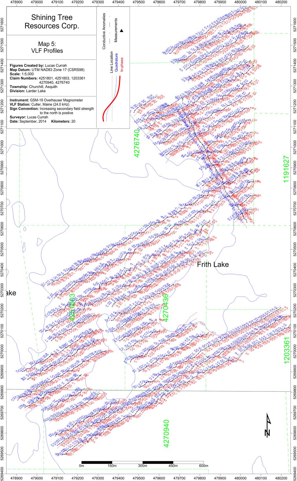
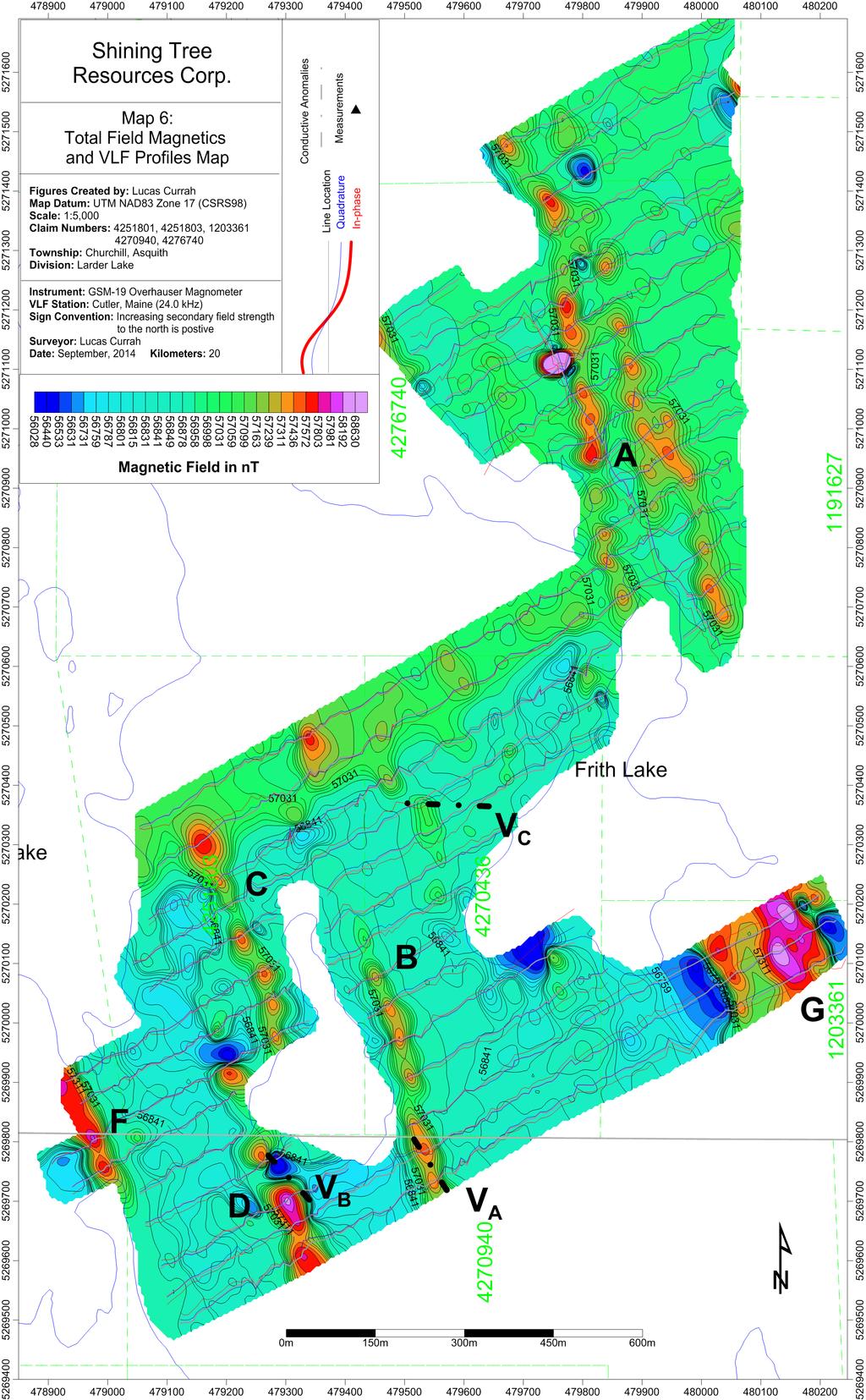
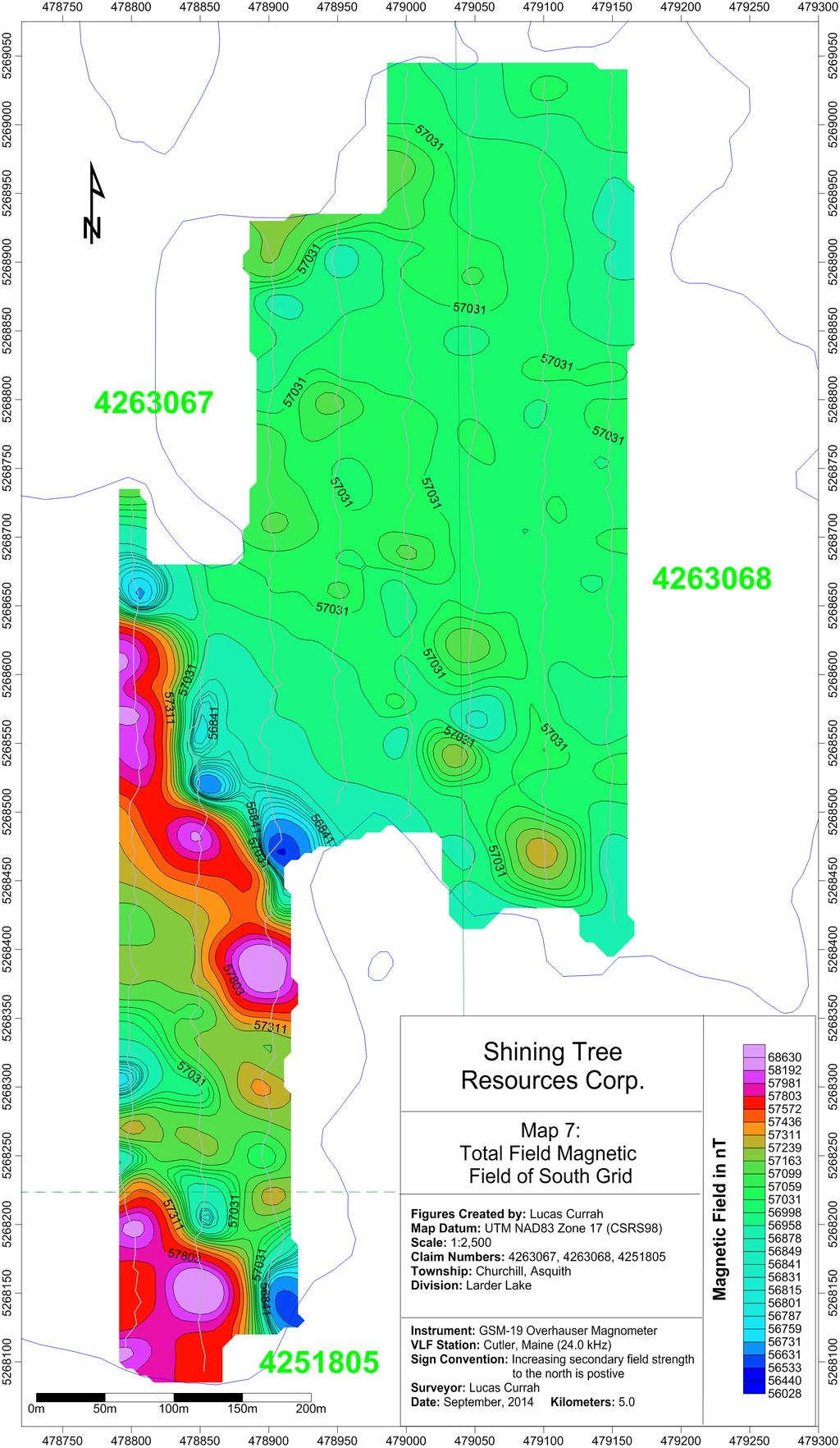
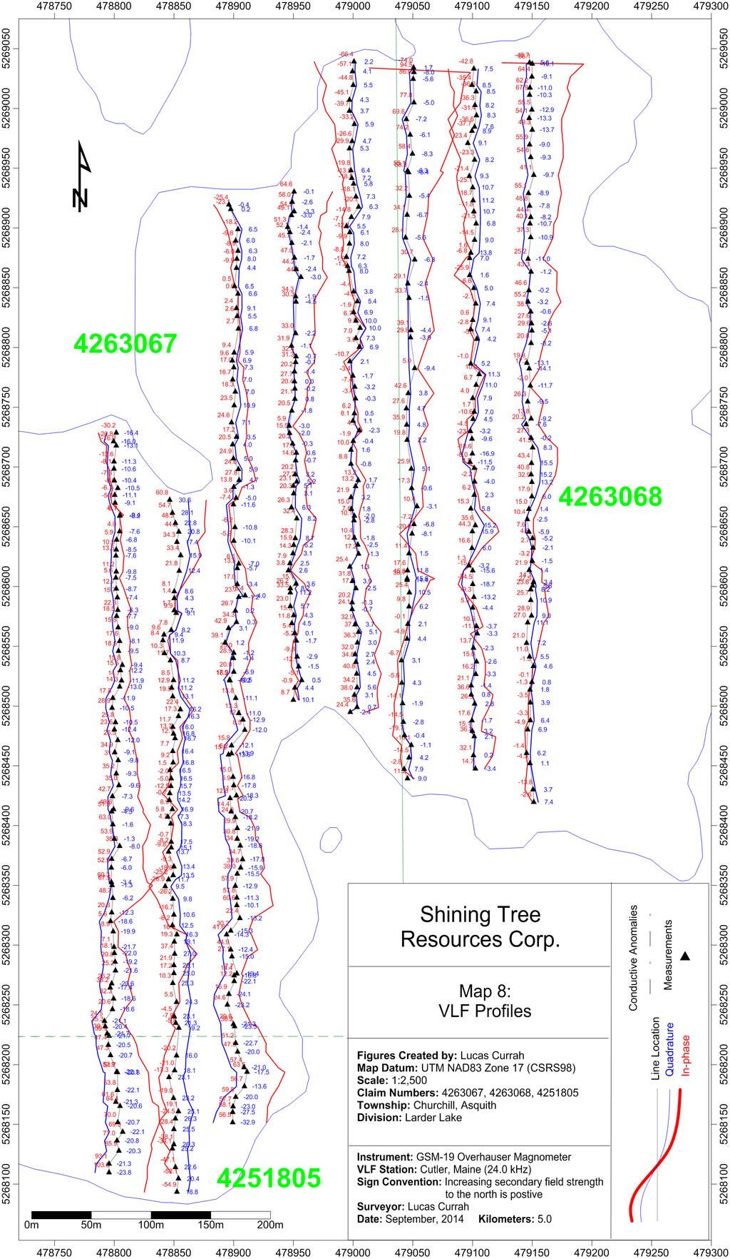
5 Lines were not cut, and the instrument operator, who was also the author, followed a person navigating via compass, using a handheld GPS as a guide. Map 3 shows the layout of both the North and South grids. Magnetic Survey A GSM-19 Overhauser Magnetometer with a synchronized GPS system was used to collect magnetic field readings. Readings were collected at 2 second intervals, and were corrected for diurnal variations using a stationary proton procession magnetometer and applied using Gem-Link 5.2 software. Base station readings were collected at 10 second intervals using a reference field of 57,000 nt. A summary of the magnetometer specifications is shown in Table 2. Table 2. Specifications for GSM-19 Overhausser Magnetometer Sensitivity: Resolution: Accuracy: Range: Sampling Interval: Hz 0.01 nt 0.1 nt 20, ,000 nt 2 s VLF Survey VLF readings were taken at paced distances of approximately meters. The Cutler, Maine (24.0 khz) station was used and percentage in-phase and out-of-phase (quadrature) components measured relative to the horizontal field. Only station readings with signal strengths greater than seven picotesla (7 pt) were utilized in interpretation. The instrument has self-leveling features, and a sensitivity of 0.1 % for phase component measurements. Data Processing and Interpretation Magnetic field measurements were selected for signal strength values greater than 49 to ensure quality readings. Magnetic field measurements were interpreted using Surfer 11 software employing the Kriging interpolation method. An anisotropic search radius oriented 330/150 degrees was selected for interpolation. The resulting grid was smoothed using a 9x9 Gaussian filter to better delineate trends, and the resulting contour map is shown in Map 4 for the north grid, and Map 7 for the south grid. The VLF profiles were interpolated linearly with respect to line direction from the raw VLF in-phase and out-of-phase components. These were overlain on a map with projection of the IP/OP readings projected perpendicular to the line direction, at a scale of 1 cm to 100 %. Map 5 shows the results for the north grid, and Map 8 for the south grid. 4
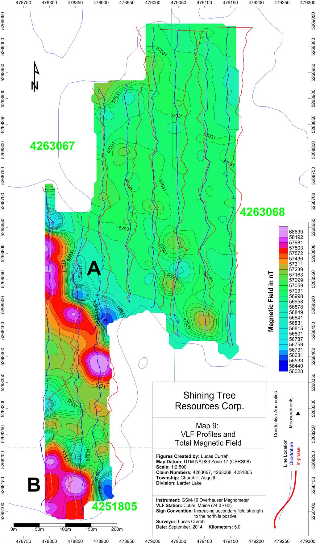
6 Results North Grid The magnetic data showed 5 northwest to north-northwest trending magnetic highs. These magnetic highs were flanked by local magnetic lows of limited spatial extents, and typically had local maxima with significantly increased magnetic field values. Anomaly A is associated with felsic volcanic units on regional mapping, and the others strike sub-parallel to slight west-of-north striking diabase dykes and fault structures. Anomalies B, C, and D are proximal to regional map p ed N/S fault. Anomaly E occurs in what is mapped as mafic volcanics. Determining the exact cause of these anomalies with the current geologic data is difficult. Anomaly G is overlapping with the northern extension of the one indentified in previous geophysical work completed by Shining Tree Resources Corp., and information is available in the report by Ploeger (2012). Anomalies for the north grid are displayed in Map 6. VLF-EM data appeared to show limited response over the entirety of the northern grid, with the exception of a few poorly defined, weak conductors. This is similar to those anomalies found by Tshimbalanga & Simoneau (2008), where weakly defined E-W VLF-EM conductors were located. Poor coupling due to line orientation may be a factor contributing to these results, as the previous survey used more N/S oriented lines, and identified more, and slightly stronger conductors. A weak conductor (V a ) appear to strike sub-parallel to magnetic anomaly B, and another weak conductor, V B occurs subparallel to anomaly D. This VLF anomaly is associated with a magnetic low. However, the weak response of these anomalies may suggest a surficial source and not a bedrock source is responsible for the responses. A final anomaly, V C, is a weak anomaly striking E/W and is not associated with a magnetic anomaly. This anomaly is the same one identified in the survey completed by Golden Valley Mines (Tshimbalanga & Simoneau, 2008). South Grid Two parallel magnetic features trending northwest were observed in the south grid, anomalies A and B. These anomalies are presented in Map 9. These anomalies appear to correspond with NW trending felsic volcanic units on the island, as mapped at regional scale by Carter (1989). The area between these two anomalies appears to correspond with VLF peaks, responses that may be caused by geologic contacts between rock units with different conductivities. The anomaly is not labeled as the exact location is difficult to discern, which is most likely caused by the oblique crossing of the contact with the survey lines. Therefore, these anomalies are most likely caused by contacts between felsic volcanics and mafic volcanics trending NW. The northern area where strong VLF-EM anomalies were associated with E/W trending shear zones were not well delineated by the survey, as was expected from previous work completed for Vintage Mines (McCannell, 1974). No magnetic trends or structures appear to be associated with this trend. However, the author did notice a trench corresponding to the location of the shear zone during the completion of the survey, suggesting that the survey lines did traverse this feature. 5
7 At the north end of the eastern most lines, it appears that high VLF measurements are entering a peak. However, it is difficult to determine the type of anomaly this represents due to the termination of the survey lines. Conclusions and Recommendations North Grid The anomalies on the northern grid are sub-parallel to both the fabric of geologic contacts, fault structures, and diabase dykes (Carter, 1989). Local prospecting and soil sampling over these anomalies in the West of the northern grid area is warranted to determine the cause of the magnetic structures, and their potential relationship to gold mineralization. Identification of outcropping of altered komatiitic rocks to the West of Nora Lake are associated with a similar magnetic trend, and are shown to host lower-grade gold mineralization, (Sharpley, 2012) (Ploeger, 2012). It is recommended that special attention to anomalies B and D are given near the weak and poorly defined VLF-EM conductors identified. Additionally, magnetic anomaly A is associated with felsic volcanics on the regional scale geologic map. South of Speed Lake, the Gosselin Vein occurs in a shear zone in close proximity to the contact to a felsic porphyry unit. Therefore, prospecting and soil sampling on this magnetic trend is warranted to determine if similar styles of mineralization continue north of the mapped extent of the Gosselin Vein. South Grid The south grid showed similar magnetic structures, and a brief investigation via prospecting and soil sampling over the southern magnetic anomalies may be warranted to determine if this is related to potential gold mineralization. This anomaly is most likely related to a contact between two narrow bands of felsic volcanic units, with a VLF-EM response marking conductivity contrasts. However, the current survey was not successful in delineating prospecting or exploration targets related to the E/W shear zone indentified in historic exploration work. 6
8 Works Cited Carter, M. (1989). Shining Tree Area, Map 2510, Distrcits of Sudbury and Timiskaming, Precambrian Geology Series, scale 1:50,000. Ontario Geological Survey. McCannel, J. (1974). Geological Report, Vintage Mines Ltd. Vintage Mines Ltd. McCannell, J. (1974). Geophysical Survey, Vintage Mines Limited. Vintage Mines Ltd. Narex Ore Search Consultants Inc.. (1985). Bedrock Stripping, Trenching, Sampling and Soil Sampling; Gosselin Property. Onitap Resources Inc.. Ploeger, J. (2012). Induced Polarization and Magnetometer Surveys OVer the Shining Tree Property. CXS. Sharpley, F. (2012). Technical Report on the Shining Tree Property. Shining Tree Resources Corp. Tshimbalanga, S., & Simoneau, P. (2008). Magnetometric Gradient and Electromagnetic VLF Survey on Gosselin Discovery Property. Golden Valley Mines LTD. 7
9 Appendix A: Statement of Author Qualifications 1. I have graduated from Queen's University with a Bachelor of Science Degree in Engineering, majoring in geological engineering 2. I hold a current Ontario prospector's license (License Number: ) 3. I have conducted and interpreted previous radiometric, magnetic, and VLF surveys over the past 3 years. To the best of my knowledge and abilities, the statements, information and conclusions made in this report and accompanying maps and figures are correct. Signed: ffffffffffffffffffffffff Lucas Currah December 29 th,
10 Map 1: Regional Location Map 85 0'0"W 84 30'0"W 84 0'0"W 83 30'0"W 83 0'0"W 82 30'0"W 82 0'0"W 81 30'0"W 81 0'0"W 80 30'0"W 80 0'0"W 79 30'0"W 79 0'0"W 49 0'0"N Legend Property '0"N 48 30'0"N 48 0'0"N ^Shining Tree Property Provincial Borders Railways Major Cities Major Roads great_lakes ³ 144 Timmins Otto Property QUEBEC 48 30'0"N 48 0'0"N 47 30'0"N 129 ONTARIO ^ Shining Tree Property '0"N 47 0'0"N 47 0'0"N 46 30'0"N Sault Ste. Marie NUNAVUT NUNAVUT 17 Elliot Lake Sudbury North Bay 46 30'0"N 46 0'0"N 46 0'0"N ONTARIO QUEBEC '0"N '0"N 45 0'0"N 45 0'0"N 85 0'0"W 84 30'0"W 84 0'0"W 83 30'0"W 83 0'0"W 82 30'0"W 82 0'0"W 81 30'0"W 81 0'0"W 80 30'0"W km 80 0'0"W 79 30'0"W 79 0'0"W
11 Map 2: Shining Tree Property Claims ³ CONNAUGHT Legend CHURCHILL MACMURCHY Township Regional Claims Regional Patents MIRAMICHI Primary Roads Utilities Secondary Roads Company Claims Lakes Rivers ASQUITH FAWCETT km :50,000 UTM NAD83 Z17N
12 Map 3: Grid Layout ³ CHURCHILL Text Legend Grid Lines base Townships Regional Claims Regional Patents ASQUITH Primary Roads Utilities Secondary Roads Lakes Rivers km :20,000 UTM NAD83 Z17N
13
14
15
16
17
18
Total Magnetic Field and VLF Surveys on the Swayze Property. Claim Swayze Township. Porcupine Mining Division
 1 January, 016 NTS: 041 O 15 Total Magnetic Field and VLF Surveys on the Swayze Property Claim 475471 Swayze Township Porcupine Mining Division 380850E, 599450N UTM Z17N NAD83 Report Prepared for: 540
Report of Gridding and Magnetic Surveys. On the. Munro Property. Munro and Beatty Townships, Ontario. Larder Lake Mining Division
 Report of Gridding and Magnetic Surveys On the Munro Property Munro and Beatty Townships, Ontario Larder Lake Mining Division Claims: 39 4244 For Big Red Diamond Corporation October 3, 2 Timmins, Ontario
We are committed to providing accessible customer service. If you need accessible formats or communications supports, please contact us.
 We are committed to providing accessible customer service. If you need accessible formats or communications supports, please contact us. Nous tenons à améliorer l accessibilité des services à la clientèle.
FANCAMP EXPLORATION LTD.
 FANCAMP EXPLORATION LTD. Fancamp Exploration Ltd. Overview of Ontario Projects Prepared by: J. Kleinboeck, P.Geo. August 4 th, 2018 Dorothy Lake Project Comprised of 104 unpatented claims covering an
We are committed to providing accessible customer service. If you need accessible formats or communications supports, please contact us.
 We are committed to providing accessible customer service. If you need accessible formats or communications supports, please contact us. Nous tenons à améliorer l accessibilité des services à la clientèle.
Project 81. Drill Ready Geophysical Targets & Trends. Timmins-Cochrane Northern Ontario Canada
 Project 81 Drill Ready Geophysical Targets & Trends Timmins-Cochrane Northern Ontario Canada FORWARD-LOOKING STATEMENT Certain statements contained in this presentation that are forwardlooking in nature
Summary of Rover Metals Geologic Mapping Program at the Up Town Gold Project, Northwest Territories
 October 13, 2017 Summary of Rover Metals Geologic Mapping Program at the Up Town Gold Project, Northwest Territories Vancouver, British Columbia, Canada - Rover Metals Corp., Rover, is pleased to provide
Queenston intersects Contact Zone on the Pandora Property and new gold zones in Kirkland Lake
 1 Queenston intersects Contact Zone on the Pandora Property and new gold zones in Kirkland Lake TORONTO, Ontario, March 7, 2003. Queenston Mining Inc. (QMI-TSX) reports diamond drill results on its 100%
41P11SE2001 OP93-39S ASQUITH
 41P11SE2001 OP93-39S ASQUITH 010 REPORT ON THE PROSPECTING, GEOPHYSICAL AND GEOLOGICAL SURVEYING PROGRAM BY HARRY FERDERBER ON THE PROPERTY OF TRINITY EXPLORATIONS ASQUITH TOWNSHIP, LARDER LAKE MINING
REPORT ON GEOPHYSICAL SURVEYS ON THE BAMAJI LAKE PROPERTY CROBIE PROJECT, NW ONTARIO OF UMEX INC.
 S20e3NWe«28 S20«3NWee37 FRY LAKE 0 1 0 REPORT ON GEOPHYSICAL SURVEYS ON THE BAMAJI LAKE PROPERTY CROBIE PROJECT, NW ONTARIO OF UMEX INC. Patricia Mining Division NTS 52 0/3 Latitude 51 10'N Longitude 91
TIGER GOLD EXPLORATION CORPORATION. Prospecting Over the HARKER HERITAGE PROPERTY AREA 10. Harker Township, Ontario
 PO Box 219, 14579 Government Road, Larder Lake, Ontario, P0K 1L0, Canada Phone (705) 643-2345 Fax (705) 643-2191 www.cxsltd.com TIGER GOLD EXPLORATION CORPORATION Prospecting Over the HARKER HERITAGE PROPERTY
SEDEX MINING CORPORATION LTD.
 P.O. Box 219, 14579 Government Road, Larder Lake, Ontario, Canada, P0K 1L0 Telephone: +1 705.643.2345 Facsimile: +1 705.643.2191 Email: katrine@larder.ca www.explorationservices.ca SEDEX MINING CORPORATION
RECEIVED. tn r-"t."' Magnetometer and VLF-EM Surveys Assessment Report. South Cobalt Silver Project South Lorrain Twp. Mhakari Gold Corp.
 RECEVED APR 1 5 111 OOSC!C! AESSMET tn r-"t. Magnetometer and VLF-EM Surveys Assessment Report South Cobalt Silver Project South Lorrain Twp. Mhakari Gold Corp. March 211 TS 31 M/3-4 Meegwich Consultants
Rockstar Gold Property Goudreau-Dog Lake Area, Wawa, Ontario. Argo Gold Inc. (ARQ)
") Rockstar Gold Property Goudreau-Dog Lake Area, Wawa, Ontario Argo Gold Inc. (ARQ) Location Map, Rockstar Gold Property Land Tenure, Rockstar Gold Property Regional Geology Michipicoten Greenstone Belt
Rockstar Gold Property Goudreau-Dog Lake Area, Wawa, Ontario Argo Gold Inc. (ARQ) Location Map, Rockstar Gold Property Land Tenure, Rockstar Gold Property Regional Geology Michipicoten Greenstone Belt
Report of Induced Polarization Surveys and. Total Field Magnetic Surveys. Turtle Pond, Emmons Lake, Prig, North Glatz, Glatz, and Double E Grids
 Report of nduced Polarization Surveys and Total Field Magnetic Surveys On the Turtlepond Project Turtle Pond, Emmons Lake, Prig, North Glatz, Glatz, and Double E Grids Turtlepond Lake Area, Ontario Claim
Assessment Report by the Canadian Nickel Co. Ltd. Magnetometer Survey. Larder Lake Mining Division Lebel Tovnship, Ontario
 32084Nwea67 2.331* LEBEL 010 Assessment Report by the Canadian Nickel Co. Ltd. Magnetometer Survey Larder Lake Mining Division Lebel Tovnship, Ontario Claims L-531657 L-531658 L-531111 Map No.: M-359,
ASSESSMENT REPORT MAGNETOMETER SURVEY GOLDEN ROD, GOLDEN ROD #2. Long.: General Delivery, Vananda, B. C.
 ASSESSMENT REPORT MAGNETOMETER SURVEY GOLDEN ROD, GOLDEN ROD #2 t=/ NTS 92~110w Lat.: Long.: 49O 44' N 124O 34' W Owner: E. Johanson General Delivery, Vananda, B. C. Operator: Rhyolite Resources I nc.
Toronto, Ontario November 16, This report may not be reproduced, in whole or in part, without the written permission of Derry, Michener S Booth.
 13 2.1354 L ITTLE 010 GEOPHYSICAL SURVEYS, LITTLE TOWNSHIP CLAIM GROUP OB-F TIMMINS AREA PORCUPINE MINING DIVISION, ONTARIO Toronto, Ontario November 16, 1973 This report may not be reproduced, in whole
Detour West Gold Project Technical Overview. April, 2018
 Detour West Gold Project Technical Overview April, 2018 Detour West Project Overview Detour West is a 7,680 hectare property located at the northwest margin of the Abitibi Greenstone Belt, 20 km west of
SUMMARY REPORT. ESSAR STEEL ALGOMA INC. 105 West Street, Sault Ste. Marie, Ontario, Canada P6A 7B4
 SUMMARY REPORT IRON LAKE PROPERTY Keating and Keating Additional Townships, Ontario, Canada ESSAR STEEL ALGOMA INC. 105 West Street, Sault Ste. Marie, Ontario, Canada P6A 7B4 Date: March 18, 2013 Prepared
PROSPECTING Survey Over the AULD PROPERTY Auld Township, Ontario
 PO Box 219, 14579 Government Road, Larder Lake, Ontario, P0K 1L0, Canada Phone (705) 643-2345 Fax (705) 643-2191 www.cxsltd.com PROSPECTING Survey Over the AULD PROPERTY C Jason Ploeger, B.Sc, P.Geo August
ANTLER GOLD DRILLS GRAMS PER TONNE GOLD OVER 5.35 METRES AT THE WILDING LAKE GOLD PROJECT, NEWFOUNDLAND
 ANTLER GOLD DRILLS 10.01 GRAMS PER TONNE GOLD OVER 5.35 METRES AT THE WILDING LAKE GOLD PROJECT, NEWFOUNDLAND HALIFAX, NOVA SCOTIA (CNW December 13 th, 2017) Antler Gold Inc. ( Antler ) (TSX- V:ANTL) is
Montgomery Bedrock Geology 21d-Gowganda Formation: conglomerate, sandstone, siltstone, argillite
 Work Report 2014 Trenching Montgomery Township G-3303 Claim #4259384,4245818 Sault Ste. Marie Mining Division Michael & Yvon Gagne Montgomery Copper Property 1 P a g e 2 P a g e Montgomery Bedrock Geology
Mishi Lake Gold Property Mishibishu Lake Area, Wawa
 Mishi Lake Gold Property Mishibishu Lake Area, Wawa Location, Accessibility, Infrastructure and Local Resources The property is located 40 km west of Wawa, Ontario, in the Mishibishu Lake Area, Sault Ste.
We are committed to providing accessible customer service. If you need accessible formats or communications supports, please contact us.
 We are committed to providing accessible customer service. If you need accessible formats or communications supports, please contact us. Nous tenons à améliorer l accessibilité des services à la clientèle.
CHAMPION BEAR RESOURCES
 CHAMPION BEAR RESOURCES EXPLORING ADVANCED STAGE PRECIOUS METAL PROPERTIES IN ONTARIO Exploration Update January 2011 Forward Looking Statements This exploration update contains forward looking statements
McVicar Lake Gold Property Lang Lake Greenstone Belt Ontario. Argo Gold Inc. (ARQ)
") McVicar Lake Gold Property Lang Lake Greenstone Belt Ontario Argo Gold Inc. (ARQ) Forward Looking Statements This presentation may contain forward-looking statements that involve a number of risks and
McVicar Lake Gold Property Lang Lake Greenstone Belt Ontario Argo Gold Inc. (ARQ) Forward Looking Statements This presentation may contain forward-looking statements that involve a number of risks and
Great Atlantic Rock Samples Return up to 5.8 oz. / ton Gold Golden Promise Property in Central Newfoundland
 Great Atlantic Rock Samples Return up to 5.8 oz. / ton Gold Golden Promise Property in Central Newfoundland FOCUSED ON EXPLORING ATLANTIC CANADA (TSXV : GR) (FRA: PH01) VANCOUVER, British Columbia August
SUPPLEMENT TO MAGNETOMETER 6 ELECTROMAGNETIC SURVEY REPORT. DATED NOVEMBER l, 1973 CIGLEN INVESTMENTS LIMITED CLAIMS GROUP BAD VERMILLION LAKE AREA
 ^ A R l ^ 1974 010 PROJECTS UNIT SUPPLEMENT TO MAGNETOMETER 6 ELECTROMAGNETIC SURVEY REPORT DATED NOVEMBER l, 1973 CIGLEN INVESTMENTS LIMITED CLAIMS GROUP BAD VERMILLION LAKE AREA DISTRICT OF RAINY RIVER
FIRST YEAR ASSESSMENT REPORT PROSPECTING LICENCE 16512M MARYSTOWN AREA, BURIN PENINSULA NTS 1M/3
 FIRST YEAR ASSESSMENT REPORT OF PROSPECTING ON LICENCE 16512M MARYSTOWN AREA, BURIN PENINSULA NTS 1M/3 BY NATHANIEL NOEL MSc. FOR E. MICHELE NOEL MINERAL LICENCES: 16512 M WORK CONDUCTED: MID-SEPTEMBER
SUMMARY REPORT. RE-ESTABLISH CLAIM BOUNDARY (Claim ) CARR TOWNSHIP (Larder Lake Mining Division) NTS (42 Al09) FOR
 CARR TOWNSHIP (Larder Lake Mining Division) NTS (42 Al09) FOR") 2.44330 " SUMMARY REPORT RE-ESTABLISH CLAIM BOUNDARY (Claim 3002288) CARR TOWNSHIP (Larder Lake Mining Division) NTS (42 Al09) FOR ST ANDREW GOLDFIELDS LTD. ""'1,.I Les 1. Kovacs, P. Geo For: St Andrew
2.44330 " SUMMARY REPORT RE-ESTABLISH CLAIM BOUNDARY (Claim 3002288) CARR TOWNSHIP (Larder Lake Mining Division) NTS (42 Al09) FOR ST ANDREW GOLDFIELDS LTD. ""'1,.I Les 1. Kovacs, P. Geo For: St Andrew
Uncovering The Riches of the Abitibi Greenstone Belt of Canada
 1 TSX.V: ALZ June 2016 Uncovering The Riches of the Abitibi Greenstone Belt of Canada The Haultain Gold Discovery The Abitibi Greenstone Belt & Gold 170+ million oz of gold produced to date from more than
TIGER GOLD EXPLORATION CORPORATION. Prospecting Over the HARKER HERITAGE PROPERTY AREA 1. Clifford Township, Ontario
 PO Box 219, 14579 Government Road, Larder Lake, Ontario, P0K 1L0, Canada Phone (705) 643-2345 Fax (705) 643-2191 www.cxsltd.com TIGER GOLD EXPLORATION CORPORATION Prospecting Over the HARKER HERITAGE PROPERTY
Report. Mining Claim SO Butt Township. District of Nipissing. Southern Ontario Mining District. Richard Keevil ~ Geologist. August 29,2006.
 Report On Mining Claim SO 1077365 Butt Township District of Nipissing Southern Ontario Mining District ~ "'_I ""'..1 D I..:"'.U&O... ~u ~]. Richard Keevil ~ Geologist August 29,2006. Richard R. Keevil,
MAGNETIC SURVEY REPORT. on the O'BRIEN CLAIM GROUP. Deloro Township Porcupine Mining Division, Ontario. for PAMOUR PORCUPINE MINES LIMITED
 42A06NE0456 2.7439 DELORO 010 MAGNETIC SURVEY REPORT on the O'BRIEN CLAIM GROUP Deloro Township Porcupine Mining Division, Ontario as se C/J 1* m O for PAMOUR PORCUPINE MINES LIMITED by Kian A. Jensen,
Dalradian Reports Regional Gold and Base Metal Targets for the Tyrone Project. Drill Rig 6 Arrives to Start Scout Drilling Program
 2011 No. 11 TSX: DNA, DNA.WT Dalradian Reports Regional Gold and Base Metal Targets for the Tyrone Project. Drill Rig 6 Arrives to Start Scout Drilling Program TORONTO, ONTARIO - (Marketwire - July 28,
John A. Wakeford Noranda Exploration Co., Ltd, November 4, 1980 rinnnins, Ontario
 42CC1NEfc4e9 801101 ECHUM 010 " ' i-^y&sg?' '.. -.r. K;VW\\:.!^-*.]-^--'^-r-r^Pj^Q..-. ;,: v 1,;-'-,..- ^^-^^^^ysr-r^ijjfiv^jj. v -." ". '. ' "i - '' '. '':.;': s.'.ilv'., p...--'*l r-j@tw IP ^vt'.'v*:-^
704,000 OUNCE MIYABI GOLD PROJECT UPDATE
 704,000 OUNCE MIYABI GOLD PROJECT UPDATE ASX/ RELEASE 21 April 2016 ASX code RVY Board of Directors: Geoff Gilmour Managing Director Greg Cunnold Technical Director Graeme Clatworthy Non-Executive Director
RECONNAISSANCE AND SOIL GEOCHEMICAL SAMPLING REPORT PORCUPINE MINING DIVISION ON CLAIM , LANGMUIR TOWNSHIP
 RECONNAISSANCE AND SOIL GEOCHEMICAL SAMPLING REPORT ON CLAIM 1224499, LANGMUIR TOWNSHIP PORCUPINE MINING DIVISION CLM 1224499 NTS: 42A/06 Author: William Randall, P.Geo 1 Table of Contents Work Performed
GROUND GEOPHYSICAL SURVEYS Magnetometer and Horizontal Loop EM. KoKoKo Project Ferrim Lake and Tasse Lake Grids. PANTHEON VENTURES LTD.
 NTS 31 M/4 GROUND GEOPHYSCAL SURVEYS Magnetometer and Horizontal Loop EM KoKoKo Project Ferrim Lake and Tasse Lake Grids PANTHEON VENTURES LTD. September 2007,..-- :. 57 RECEVED JAN 16 ~'2:n GEOSCENCf
SnipGold Advances Lower McFadden to Drill-Ready Status
 News Release NR: 16 03 March 3, 2016 SnipGold Advances Lower McFadden to Drill-Ready Status SnipGold Corp. ( SnipGold or the Company ) is pleased to announce positive results of a 2015 ground electromagnetic
First Year assessment Report on Prospecting and Rock sampling, King George property, License M NTS 12A/05 Newfoundland and Labrador.
 First Year assessment Report on Prospecting and Rock sampling, King George property, License 016679M NTS 12A/05 Newfoundland and Labrador. Submitted by Shawn Rose For Shawn Rose January 2011 Work year
Introducti on. Land Survey. Geomagnetic Survey. Geomagnetic Results and Interpretati ons - Conclusions and Recommendations C
 m M 42A86SW8281 63.42 PRICE 010 C O H T E H l 42A86SW828I 63.42 PRICE 010C Introducti on Land Survey Geomagnetic Survey Geomagnetic Results and Interpretati ons - Conclusions and Recommendations - - -
CJP EXPLORATION INC.
 PO Box 219 14579 Government Road Larder Lake, Ontario P0K 1L0, Canada Phone (705) 643-1122 Fax (705) 643-2191 CJP EXPLORATION INC. Spectrometer Survey Over the SHEBA PROPERTY Nouvel Township, Ontario TABLE
for the Greenwood Mining Division, B.C. NTS 82E/7W Latitude 49' 27' W, Longitude 118' 5 Prepared by a= D. Dylan Watt, B.Sc.
 t. b LOGnO: 37~ -08 m. ACTIO#: for the AMP AMP 2 AMP 3 t AMP 4 CLAIMS Greenwood Mining Division, B.C. NTS 82E/7W Latitude 49' 27' W, Longitude 8' 5 %E c,w zc *& a w Prepared by a= -4c. D. Dylan Watt, B.Sc.
MORE HIGH-GRADE GOLD INTERSECTIONS FROM CITADEL S SHAYBAN PROJECT, SAUDI ARABIA
 Citadel Resource Group Limited ASX Release 7th July 2009 MORE HIGH-GRADE GOLD INTERSECTIONS FROM CITADEL S SHAYBAN PROJECT, SAUDI ARABIA Highlights: LATEST RC IN-FILL AND EXTENSIONAL DRILLING CONTINUES
REPORT ON DIAMOND DRILLING SUBSTITUTION EAST PROPERTY CLAIMS AND HEBERT TOWNSHIP ONTARIO, CANADA
 REPORT ON DIAMOND DRILLING SUBSTITUTION EAST PROPERTY CLAIMS 1248920 AND 1248921 HEBERT TOWNSHIP ONTARIO, CANADA Adroit Resources Inc. Suite #610-1111 Melville Street Vancouver, British Columbia, Canada
Probe Metals Confirms Continuity of Gold Mineralization on its Val-d Or East Project And Increases 2017 Drill Program to 75,000 metres
 NEWS RELEASE 07/2017 Symbol: TSX-V: PRB Shares Issued: 93,328,938 Probe Metals Confirms Continuity of Gold Mineralization on its Val-d Or East Project And Increases 2017 Drill Program to 75,000 metres
r ffj Ronald C. Wells, BSc. Lacana Mining Corporation LACANA CLAIMS GAUTMER TOWNSMP GEOPHYSICAL REPORT OCT LARDER LAKE MINING DIVISION
 a- 32D04NWei39 2.3507 GAUTHIER 010 GEOPHYSICAL REPORT LACANA CLAIMS GAUTMER TOWNSMP LARDER LAKE MINING DIVISION RECEIVED OCT171980 MINING UNDS SECTION Author: Ronald C. Wells, BSc. Lacana Mining Corporation
2014 AEROQUEST AIRBORNE HELI-BORNE VTEM PLUS AND HORIZONTAL MAGNETIC GRADIOMETER SURVEY ASSESSMENT REPORT CAMERON GOLD PROJECT
 2014 AEROQUEST AIRBORNE HELI-BORNE VTEM PLUS AND HORIZONTAL MAGNETIC GRADIOMETER SURVEY ASSESSMENT REPORT CAMERON GOLD PROJECT PREPARED BY: Nick Walker. January 2015 SUMMARY This report presents the results
for the Greenwood Mining Division, B.C. NTS 82E/7W 29' W, Longitude 118' 53' N Prepared by D. Dylan Watt, B.Sc.
 for the FltE NO: u VOLT 1, VOLT 2, VOLT 3, & VOLT 4 CLAIMS Greenwood Mining Division, B.C. NTS 82E/7W Latitude 49' 29' W, Longitude 118' 53' N Prepared by D. Dylan Watt, B.Sc. #309-1996 Trutch Street Vancouver,
We are committed to providing accessible customer service. If you need accessible formats or communications supports, please contact us.
 We are committed to providing accessible customer service. If you need accessible formats or communications supports, please contact us. Nous tenons à améliorer l accessibilité des services à la clientèle.
MINERAL MOUNTAIN RESOURCES LTD. MMV.TSX-V
 MINERAL MOUNTAIN RESOURCES LTD. 201-1416 West 8 th Avenue Vancouver, B.C. V6H 1E1 T: 604-714-0111 F: 604-714-1119 MMV.TSX-V NEWS RELEASE March 3, 2011 No. 2011-04 MINERAL MOUNTAIN DRILLS 3.17 g/t OVER
STRONG GOLD IN SOIL ANOMALY OUTLINED AT MARY HARRISON PROJECT HIGHLIGHTS
 National Stock Exchange of Australia Company Announcements Level 2, 117 Scott Street Newcastle NSW 2300 25 th January 2013 STRONG GOLD IN SOIL ANOMALY OUTLINED AT MARY HARRISON PROJECT HIGHLIGHTS 100m
Scadding Property Sudbury District, Ontario
 FOR IMMEDIATE RELEASE Northern Sphere Mining Corp. optimizes mineral targets on its Sudbury Nickel Belt and Arizona Porphyry Copper properties Toronto, Ontario April 5, 2018 - Northern Sphere Mining Corp.
State Metallic Minerals Lease Sale Minnesota s Vermilion Gold District
 State Metallic Minerals Lease Sale Minnesota s Vermilion Gold District State Metallic Minerals Lease Sale Notice of Intent Scale 1:100,000 State Metallic Minerals Lease Sale This portion of the lease sale
FILE NO. ASSESSMENT REPORT VLF-EM GEOPHY S I CS BUCK CLAIMS. Moyie River and Perry Creek Area FORT STEELE MINING DIVISION. NTS 82 F/8 E and 82 G/5 W
 FILE NO. ASSESSMENT REPORT on - VLF-EM GEOPHY S I CS BUCK CLAIMS Moyie River and Perry Creek Area FORT STEELE MINING DIVISION NTS 82 F/8 E and 82 G/5 W Latitude 49 27' N Longitude 116 03' W PETER KLEWCHUK
We are committed to providing accessible customer service. If you need accessible formats or communications supports, please contact us.
 We are committed to providing accessible customer service. If you need accessible formats or communications supports, please contact us. Nous tenons à améliorer l accessibilité des services à la clientèle.
CARIBOO - GRIZZLY ZINC PROJECT
 CARIBOO - GRIZZLY ZINC PROJECT The Grizzly Lake or Cariboo Zinc property straddles the gravel Weldwood 8400 logging road in the Grizzly Lake area about 55 kilometres northeast of Likely. Roads constructed
Elephant Mountain, Alaska Intrusive Related Gold Project July Option to Earn 100%
 Elephant Mountain, Alaska Intrusive Related Gold Project July 2018 Option to Earn 100% CORPORATE Corporate DISCLOSURE Disclosure The information contained herein, while obtained from sources which we believe
We are committed to providing accessible customer service. If you need accessible formats or communications supports, please contact us.
 We are committed to providing accessible customer service. If you need accessible formats or communications supports, please contact us. Nous tenons à améliorer l accessibilité des services à la clientèle.
TECHNICAL REPORT ON THE BLACK CREEK PROPERTY FOR CARRIE ARRAN RESOURCES BLACK TOWNSHIP LARDER LAKE MINING DIVISION ONTARIO
 TECHNICAL REPORT ON THE BLACK CREEK PROPERTY FOR CARRIE ARRAN RESOURCES BLACK TOWNSHIP LARDER LAKE MINING DIVISION ONTARIO B.J. McKay, 8 February 2011 Keewatin, Ontario TECHNICAL REPORT BJML 2011 Table
Burchell Lake, A Copper, Gold and Molybdenum Property In Ontario. Corporate Presentation September, 2013
 Burchell Lake, A Copper, Gold and Molybdenum Property In Ontario Corporate Presentation September, 2013 Background Tanager Energy Inc. is a Canadian corporation whose shares are traded on the TSX Venture
ASX / MEDIA RELEASE 6 MAY MILE SILVER-LEAD-ZINC DISCOVERY; HIGH GRADE SILVER-GOLD IN ROCK CHIPS AT RUBY SILVER
 ASX / MEDIA RELEASE 6 MAY 2011 4-MILE SILVER-LEAD-ZINC DISCOVERY; HIGH GRADE SILVER-GOLD IN ROCK CHIPS AT RUBY SILVER Highlights: Silver-lead-zinc discovery at 4-Mile; mineralisation intersected in all
TERAS FLAGSHIP CAHUILLA PROJECT
 TERAS FLAGSHIP CAHUILLA PROJECT Cahuilla Company s Main Asset is located in mining friendly Imperial County, California. Mine Development Associates completed a NI 43-101 resource report; reporting an
December 6th I960. President and Directors, Chipman Lake Mines Ltd. 25 King Street West, Toronto.
 OFFICE: EM, 3-3933 RES.: HU. 1-1265 "' Mfc 42A85NE0127 63.1089 GODFREY 010. D. President and Directors, Chipman Lake Mines Ltd. 25 King Street West, Toronto. December 6th I960 REPORT ON GEOPHYSICAL SURVEY
COMPASS GOLD: SOIL GEOCHEMICAL SURVEY IDENTIFIES INTENSE GOLD ANOMALIES COINCIDENT WITH CRUSTAL-SCALE FAULTS ON SANKARANI PERMIT
 COMPASS GOLD: SOIL GEOCHEMICAL SURVEY IDENTIFIES INTENSE GOLD ANOMALIES COINCIDENT WITH CRUSTAL-SCALE FAULTS ON SANKARANI PERMIT Toronto, Ontario, May 31, 2018 Compass Gold Corp. (TSX-V:CVB) (Compass or
PIOTR LUTYNSKI VANCOUVER, BRITISH COLUMBIA
 AN ASSESSMENT REPORT ON GROUND MAGNETIC SURVEYING CHUCHI PROPERTY FORT ST. JAMES AREA, BRITISH COLUMBIA OMINECA M.D. 55 17 N, 124 31 W NTS 93N/ 7&8 Claims Surveyed: 597976, 597878-597880 Survey Dates:
Spectrometer Survey Over the Creelman-Roberts Property Roberts and Creelman Townships, Ontario
 PO Box 19 1479 Government Road Larder Lake, Ontario PK 1L, Canada Phone (7) 4-11 Fax (7) 4-191 Spectrometer Survey Over the Creelman-Roberts Property Roberts and Creelman Townships, Ontario Spectrometer
HIGH GRADE GOLD-BEARING QUARTZ VEIN DISCOVERED AT MIAREE, KARRATHA AREA WESTERN AUSTRALIA
 17 November 2010 Company Announcements Office Australian Stock Exchange Limited 20 Bridge Street SYDNEY NSW 2000 HIGH GRADE GOLD-BEARING QUARTZ VEIN DISCOVERED AT MIAREE, KARRATHA AREA WESTERN AUSTRALIA
We are committed to providing accessible customer service. If you need accessible formats or communications supports, please contact us.
 We are committed to providing accessible customer service. If you need accessible formats or communications supports, please contact us. Nous tenons à améliorer l accessibilité des services à la clientèle.
News Release No GOLD AND COPPER MINERALIZATION DISCOVERED DURING PHASE 2 EXPLORATION AT THE MCBRIDE PROPERTY
 November 19, 2018 TSX Venture Exchange Listed Frankfurt Exchange Listed News Release No. 303-2018 GOLD AND COPPER MINERALIZATION DISCOVERED DURING PHASE 2 EXPLORATION AT THE MCBRIDE PROPERTY Vancouver,
AUGUSTINE VENTURES ANNOUNCES HIGH GRADE GOLD BEARING TENSION VEINS IN THE HANGING WALL OF THE SURLUGA DEPOSIT
 NEWS RELEASE November 29, 2016 AUGUSTINE VENTURES ANNOUNCES HIGH GRADE GOLD BEARING TENSION VEINS IN THE HANGING WALL OF THE SURLUGA DEPOSIT Toronto, Ontario November 29, 2016 - The Manager, Red Pine Exploration
Toronto, Canada March 4, 2013
 NEWS RELEASE SAS REPORTS ADDITIONAL DRILLING RESULTS FOR THE HISLOP NORTH AND SMOKE DEEP ZONES AND SIGNIFICANT INITIAL RESULTS FROM THE HISLOP PIT COMPLEX AND NEW SEDIMENT ZONE AT THE HOLLOWAY MINE Hislop
ANTLER GOLD EXPLORATION UPDATE, WILDING LAKE GOLD PROJECT, NEWFOUNDLAND
 ANTLER GOLD EXPLORATION UPDATE, WILDING LAKE GOLD PROJECT, NEWFOUNDLAND HALIFAX, NOVA SCOTIA (CNW May 10, 2018) Antler Gold Inc. ( Antler ) (TSX-V:ANTL) is pleased to provide an update on its upcoming
Melkior Drills Shallow Holes on Zam Zam and Jowsey Gold Zones and Intersects 33.1 g/t over 1.18 Metres
 Melkior Drills Shallow Holes on Zam Zam and Jowsey Gold Zones and Intersects 33.1 g/t over 1.18 Metres July 26, 2016 Trading Symbol: MKR TSX Venture Exchange Ottawa, Ontario. Melkior Resources Inc. ( Melkior
Reconnaissance. Of the. Denis mineral claims. Situated at Kilometer 844 of the Alaska Highway. Liard Mining Division. Northeastern British Columbia
 Reconnaissance Of the Denis mineral claims Situated at Kilometer 844 of the Alaska Highway Liard Mining Division Northeastern British Columbia N.T.S. 94M.075 Latitude 59 42 25 Longitude 127 13 12 Field
We are committed to providing accessible customer service. If you need accessible formats or communications supports, please contact us.
 We are committed to providing accessible customer service. If you need accessible formats or communications supports, please contact us. Nous tenons à améliorer l accessibilité des services à la clientèle.
Gold Mountain Group Gold Mtn. A, B, C & D Mineral Claims Record Nos. 697, 698, 699 & 700. Island Mountain Cariboo Mining Division British Columbia
 GOLD POINT RESOURCES LTD. Geophysical Survey Gold Mountain Group Gold Mtn. A, B, C & D Mineral Claims Record Nos. 697, 698, 699 & 700 Island Mountain Cariboo Mining Division British Columbia Vancouver,
The Company s forward-looking statements are expressly qualified in their entirety by this cautionary statement.
 Disclaimers Forward-looking statements Certain information regarding the Company contained herein constitutes forward looking statements within the meaning of applicable securities laws. Forward-looking
TRENCHING AT LAS DOLORES EXTENDS STRIKE LENGTH TO OVER 1,000 METRES, INTERSECTING
 January 31, 2018 NEWS RELEASE - #18-03 TSX- V: GRR Suite 501-595 Howe Street Vancouver, BC V6C 2T5 Tel: (604) 685-4655 Fax: (604) 685-4675 Toll Free: 1-888-685-4655 TRENCHING AT LAS DOLORES EXTENDS STRIKE
EXPLOR INTERSECTS MULTIPLE COPPER ZONES GRADES UP TO 3.65% CU OVER 5.35 METERS ON THE CHESTER COPPER PROPERTY
 15 Gamble East Street - Suite 204 - Rouyn-Noranda (Canada) J9X 3B6 Listing (TSX-V = EXS) (OTCQB = EXSFF) (FSE & BE = E1H1) EXPLOR INTERSECTS MULTIPLE COPPER ZONES GRADES UP TO 3.65% CU OVER 5.35 METERS
GEOLOGICAL MAPPING REPORT ON THE ASH MINERAL CLAIM OSOYOOS MINING DIVISION ASHNOLA RIVER MAP SHEET NTS M092,H019 MCBRIDE CREEK AREA, ASHNOLA RIVER,
 GEOLOGICAL MAPPING REPORT ON THE ASH MINERAL CLAIM OSOYOOS MINING DIVISION ASHNOLA RIVER MAP SHEET NTS M092,H019 LATITUDE 49 o O6, LONGITUDE 120 o 22 MCBRIDE CREEK AREA, ASHNOLA RIVER, KEREMEOS, B.C. CANADA
FOCUSED ON ACQUIRING, EXPLORING AND ADVANCING QUALITY MINING PROJECTS IN THE AMERICAS CORPORATE PRESENTATION 1
 FOCUSED ON ACQUIRING, EXPLORING AND ADVANCING QUALITY MINING PROJECTS IN THE AMERICAS JUNE 2018 CORPORATE PRESENTATION 1 Disclaimer Except for the statements of historical fact contained herein, certain
FIRST YEAR ASSESSMENT REPORT ON THE HAMMERDOWN SOUTH PROPERTY KING S POINT AREA, NEWFOUNDLAND
 FIRST YEAR ASSESSMENT REPORT ON THE HAMMERDOWN SOUTH PROPERTY KING S POINT AREA, NEWFOUNDLAND Licenses: 017558M, 017559M, 017560M and 017561M NTS Mapsheets: 012H/08 and 012H/09 Garry Fraser 66a Frontenac
Report on The Magnetic Survey. Property of Loydex Resources Inc. Keigat Lake Area. Red Lake Mining Division
 010 Report on The Magnetic Survey On The Property of Loydex Resources Inc. SANDY POINT PROJECT Keigat Lake Area District of Kenora, Patricia Portion Red Lake Mining Division N.T.S. 52-N-8 Whitby, Ontario
CERRO PRIETO PROJECT MINERAL CONCESSIONS LOCATION AND ACCESS
 Cerro Prieto CERRO PRIETO PROJECT MINERAL CONCESSIONS The Cerro Prieto Project is comprised of three mining exploitation concessions encompassing 2,723 hectares in northern Sonora, Mexico. Oroco holds
Two Gold Properties for Option, Northwestern Ontario
 1 Two Gold Properties for Option, Northwestern Ontario My two grassroots gold exploration properties located about 60-70 km southwest of Pickle Lake, northwestern Ontario. The properties are located near
SAN LUCAS PROJECT Technical Data
 SAN LUCAS PROJECT Technical Data 1 San Lucas Overview 3km long mineralized Main Shear zone with 2 parallel vein structures identified 79 historical RC holes, ranging from about 32m-259m and averaging 158m
Press Release Azimut and Partners announce Drilling Results from Eleonore South Gold Property, James Bay region, Quebec
 For immediate release December 17, 2018 Symbol: AZM. TSX Venture Press Release Azimut and Partners announce Drilling Results from Eleonore South Gold Property, James Bay region, Quebec Longueuil, Quebec
MONETA INTERCEPTS g/t GOLD INCLUDING g/t GOLD AND g/t GOLD INCLUDING g/t GOLD AT SOUTH WEST
 NEWS RELEASE 15/2018 Symbol: TSX: ME FOR IMMEDIATE RELEASE MONETA INTERCEPTS 5.30 m @ 7.63 g/t GOLD INCLUDING 0.80 m @ 22.40 g/t GOLD AND 7.13 m @ 5.06 g/t GOLD INCLUDING 1.98 m @ 12.47 g/t GOLD AT SOUTH
ATON RETURNS 22.2 METRES OF 2.77 GRAMS PER TONNE GOLD EQUIVALENT FROM HAMAMA WEST; VISIBLE GOLD DISCOVERED AT BOHLOG
 FOR IMMEDIATE RELEASE: ATON RETURNS 22.2 METRES OF 2.77 GRAMS PER TONNE GOLD EQUIVALENT FROM HAMAMA WEST; VISIBLE GOLD DISCOVERED AT BOHLOG Vancouver, April XX, 2017: Aton Resources Inc. (AAN: TSX-V) (
For personal use only
 ACN 097 088 689 ASX Announcement 1 EXPLORATION SUCCESS CONTINUES AT RAVENSWOOD RC drilling targeting shallow portions of Welcome breccia returns a number of significant new results including: 7m @ 7.84g/t
Lands Parcels in IOL CO-20
 Lands Parcels in IOL CO-20 1 CO-20 The Izok Corridor Lupin - multi-million ounce past gold production (3.6 million oz of gold at average grade of 9.3 g/t Au) Approximately 1 million ounces of undeveloped
Eloro Outlines Major New Mineralized Trend on La Victoria Project, Peru; Sample Results Return Values To 33 Grams Gold Per Tonne
 20 Adelaide Street East, Suite 200, Toronto, Ontario CANADA M5C 2T6 Tel.: (416) 868-9168 Fax: (416) 361-1333 TSX.V Symbol: ELO www.elororesources.com Eloro Outlines Major New Mineralized Trend on La Victoria
Fox Lake Gold Project Northwest Territories, Canada
 1 Fox Lake Gold Project Northwest Territories, Canada www.gtgoldresources.com li2992@yahoo.ca 604-998-6609 2 Cautionary Statement Certain statements herein may contain forward-looking information within
North American Palladium Announces Positive Exploration Results from Lac des Iles Mine
 North American Palladium Announces Positive Exploration Results from Lac des Iles Mine Toronto, Ontario, October 24, 2017 North American Palladium Ltd. ( NAP or the Company ) (TSX: PDL) (OTC PINK: PALDF)
RECEIVED. .* : - Al IR l MINING LANDS SECTION. Deborah McCombe Abltlbi-Price Inc. Mineral Resources Division July 28, 1981
 010 RECEIVED.* : - Al IR l 21981 MINING LANDS SECTIN REPRT N MAX-MIN II AND MAGNETIC SURVEY by ABITIBI-PRICE INC. MINERAL RESURCES DIVISIN LUCAS TWP. NTARI CLAIMS Deborah McCombe Abltlbi-Price Inc. Mineral