Montgomery Bedrock Geology 21d-Gowganda Formation: conglomerate, sandstone, siltstone, argillite
|
|
|
- Kerry Goodman
- 5 years ago
- Views:
Transcription
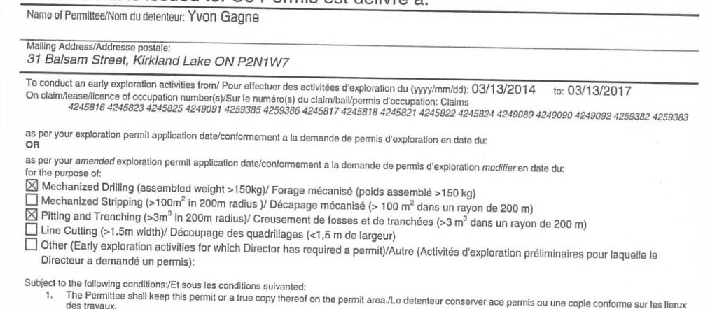
1 Work Report 2014 Trenching Montgomery Township G-3303 Claim # , Sault Ste. Marie Mining Division Michael & Yvon Gagne Montgomery Copper Property 1 P a g e

2 2 P a g e

3 Montgomery Bedrock Geology 21d-Gowganda Formation: conglomerate, sandstone, siltstone, argillite 3 P a g e
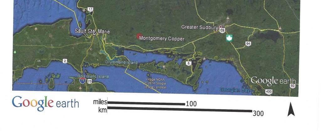
4 Property: Property consists of 15 claims 31 units in Montgomery / Nouvel Township in Sault Saint Marie mining division. Montgomery Township claim # , , , , , , Nouvel twp. claim # , , , , , , , P a g e


5 Location: Access can be reached to the property from highway 17 either from Sudbury or Sault Saint Marie to highway 546, turn north. Access to the property can also be reached by travelling south by highway 129 from Chapleau. We turn east off of highway 546 on Williamson Lake gravel road one kilometer north of Constance lake. At Williamson Lake Road we travel east for 1.3 km to the truck parking. From the park area we take the allterrain vehicles to pits, 3.4 km following the old mine road easterly. 5 P a g e


6 Work: Work was done on June 2-4 and June 10-17, areas were excavated in quartz veins, and 4 shallow pits were sunk approximately at a depth of 1 meter. The mineralized quartz vein striking North 70*West and dipping 90 degrees, containing chalcopyrite, pyrite, boronite and hematite. Host rock is Gowganda Formation, conglomerate, sandstone, siltstone or argillite. Three pits #2, 3, and 4 are on claim # and #1 pit is located on claim # All pits were drilled with an Atlas Copco Gas Plugger. We had three people working on the dates below: Michael, Yvon and Maria Gagne. 6 P a g e
7 Work Schedule Date Information Hours of work June 2 Clean road of dead falls and overhands 8 June 3 Start cutting atv. trail from old mine road to 10 #1 pit June 4 Finish trail, prospect area with Fisher 8 Gemini-3 metal detector June 10 Set up camp, clear off #1 pit and drill 6 June 11 Drill and blast 1 pit, clear off #2 pit, drill 12 June 12 Finish drill #2 pit and blast Clear off 3 pit 12 June 13 Drill and blast 3 pit Clear off 4 pit started to 12 drill June 14 Drill and blast 4 pit 12 June 15 Assay 4 pits, tear down camp 4 total 84 7 P a g e
8 8 P a g e
9 9 P a g e


10 Pit #1(blasted) Looking West Pit #1 is 1.5 meters long, 1 meter wide and 1 meter deep. This trench is drilled in milky white quartz vein with chalcopyrite/sulphide mineralization in Gowganda conglomerate sediments. Pit 1 is orientated west 20 *north and is 176 meters west and 15 meters north of #2 post of claim # Two grab assays were taken #27573 and assayed 2441 ppm and 1525 ppm copper respectfully assay areas shown on map provided. 10 P a g e


11 Pit #2 (blasted)looking South-East Pit #2 is 4 meters long, approximately 1 meter wide and 1 meter deep. This trench is drilled in milky white quartz vein that is 1.6 m wide with spotted chalcopyrite mineralization, and quartz stringers in the Gowganda Formation nearest in picture. Trench 2 is orientated west 20* north and is 228 meters west 18 meters south of #1 post of claim # No assays taken at this time. 11 P a g e


12 Pit #3(blasted) Looking South Pit #3 is 3 meters long, approximately 1.25 meter wide and 1 meter deep. This trench is drilled in milky white quartz vein that is 1.6 m wide with spotted and massive chalcopyrite mineralization, and quartz stringers in the Gowganda Formation nearest in picture. Pit 3 is orientated west 20* north and is 161 meters west 37 meters south of #1 post of claim # Assay was a grab sample of the massive chalcopyrite in quartz. Assay was a total metal of the same massive chalcopyrite in quartz. Assay location provided on map 12 P a g e

13 Assay # & #27577 taken from Pit #3 13 P a g e


14 Pit #4 (blasted) Looking North-East Pit #4 is 4 meters long, approximately 1.25 meter wide and 1 meter deep. This pit is drilled in Gowganda Formation with a milky white quartz vein that is 1.6 m wide with spotted chalcopyrite mineralization, and hematite along the north side of the pit. Pit 4 is orientated west 20* north and is 103meters west 64 meters south of #1 post of claim # Grab assays taken in quartz vein assayed 6877 ppb copper 14 P a g e
15 15 P a g e
16 16 P a g e
17 17 P a g e
18 18 P a g e
19 19 P a g e
20 20 P a g e
21 21 P a g e
22 22 P a g e

23 23 P a g e

24 24 P a g e
25 25 P a g e
Reconnaissance. Of the. Denis mineral claims. Situated at Kilometer 844 of the Alaska Highway. Liard Mining Division. Northeastern British Columbia
 Reconnaissance Of the Denis mineral claims Situated at Kilometer 844 of the Alaska Highway Liard Mining Division Northeastern British Columbia N.T.S. 94M.075 Latitude 59 42 25 Longitude 127 13 12 Field
%+ '$# $) %, %*$ " $ $ ' %' !()'-!" %( %"%! " *'+ - % %$! $)! " $)!" !$ ' "! )( ! $ '%& ')- % % "!#( (( ((# $) ' ) ((* & *# ' % %"*# ( !!
 %, %*$ $ $ ' %' !()'-! %( %%! *'+ - % %$! $)! $)! !$ ' ! )( ! $ '%& ')- % % !#( (( ((# $) ' ) ((* & *# ' % %*# ( !!") 001L/14/0218 First Year Assessment Report of Prospecting, Rock and Stream Sediment Sampling On Licence 18880M, NTS 1L/14 Burin Peninsula Newfoundland and Labrador Submitted by: Keith Kelloway Work year:
001L/14/0218 First Year Assessment Report of Prospecting, Rock and Stream Sediment Sampling On Licence 18880M, NTS 1L/14 Burin Peninsula Newfoundland and Labrador Submitted by: Keith Kelloway Work year:
CONTENTS. Location, Access and History...6. Tenure Status and Geology Regional Andy Property Geology Map...9
 TYPE OFWORK IN THIS REPORT EXTENT OF WORK (rn METRTC UNITS) ON WHICH CLAIMS PROJECT COSTS APPORTIONED (incl. support) GEOLOGICAL (scale, area) Ground, mapping Photo interpretation GEOPHYSICAL (line-kilometres)
Magnetic Field and VLF Surveys on the Shining Tree Property. Claims: , , , , , , , ,
 December 29, 2014 NTS: 041P11 Magnetic Field and VLF Surveys on the Shining Tree Property Claims: 1203361, 4251801, 4251803, 4251805, 4263067, 4263068, 4270940, 4270436, 4276740 Churchill and Asquith Townships
Prospecting Report 'S Office i DB Property, B.C. -J Negro Creek Nelson Mining District NTS 82F.050. Operator: Kootenay Gold Inc.
 . '.' I"' i9 12 Prospecting Report 'S Office i DB Property, B.C. -J Negro Creek Nelson Mining District NTS 82F.050 Operator: Kootenay Gold Inc. Owner: Darlene Lavoie Work Performed Summer of 2007 Report
Photo 119. Ripple marks in the Gordon Lake Formation. Highway 639 at the entrance to Laurentian Lodge.
 in particular of the Bruce Limestone by the Nipissing Diabase, has produced the rocks known as skarns (page 162). Regional metamorphism, particularly in the Massey - Whitefish Falls area, has produced
1 FILMED 1. FILE NO:!..rsrru -* -. GRAND TWO CLAIM
 FILE NO:!..rsrru -* -. GRAND TWO CLAIM REPORT ON 1993 ASSESSMENT WORK GRAND TWO CLAIM REC. NO. 301849 NELSON MINING DIVISION NTS MAP SHEET 82F6/W 49 25'51" NORTH 117 18'08" WEST 1 FILMED 1 AUTHOR: R. Jordan,
PROSPECTING REPORT. Silver Dollar Property. EVENT # TENURE # Tenure Name: GPEX Silver Dollar
 2008-2009 PROSPECTING REPORT Silver Dollar Property EVENT # 4267989 TENURE # 555462 Tenure Name: GPEX Silver Dollar Similkameen Mining Division Map 092H Central Coordinate Reference 120 06 26.9 W Longitude
12 tons of high-grade ore was mined from the No. 1 vein with an average grade of 13 g/t gold, 3,250 g/t silver and 23.3% lead.
 DUNWELL MINE GROUP The Dunwell Mine Group (Dunwell, Dunwell East, Bear River/MM and Silvershot properties), which includes the historic, past-producing Dunwell mine, is located 8 km northeast of Stewart
We are committed to providing accessible customer service. If you need accessible formats or communications supports, please contact us.
 We are committed to providing accessible customer service. If you need accessible formats or communications supports, please contact us. Nous tenons à améliorer l accessibilité des services à la clientèle.
PROJECT AREA CON LAKE. MAP No. G-22 - CASTLEWOOD LAKE AREA DISTRICT OF THUNDER BAY OP90-372
 42E13NE888I 63.5922 CASTLEWOOD LAKE 010 PROJECT AREA CON LAKE MAP No. G-22 - CASTLEWOOD LAKE AREA DISTRICT OF THUNDER BAY OP90-372 TECHNICAL REPORT FINAL SUBMISSION M. NELSON CLAIM BLOCK OP90-372 #1 TRENCH
First Year Assessment Report: Report on Prospecting, Rock and Soil Sampling Carried Out From September/2012 to December/2012.
 First Year Assessment Report: Report on Prospecting, Rock and Soil Sampling Carried Out From September/2012 to December/2012 on the Clarkes Pond Property Licence 020334M Northwest Gander River,Central
The MAPLE BAY PROJECT Copper Silver - Gold
 The MAPLE BAY PROJECT Copper Silver - Gold Good grade and tonnage potential within close proximity to Tidewater The Maple Bay Copper Silver Gold Project covers highly favourable geological host rocks of
John A. Wakeford Noranda Exploration Co., Ltd, November 4, 1980 rinnnins, Ontario
 42CC1NEfc4e9 801101 ECHUM 010 " ' i-^y&sg?' '.. -.r. K;VW\\:.!^-*.]-^--'^-r-r^Pj^Q..-. ;,: v 1,;-'-,..- ^^-^^^^ysr-r^ijjfiv^jj. v -." ". '. ' "i - '' '. '':.;': s.'.ilv'., p...--'*l r-j@tw IP ^vt'.'v*:-^
Uncovering The Riches of the Abitibi Greenstone Belt of Canada
 1 TSX.V: ALZ June 2016 Uncovering The Riches of the Abitibi Greenstone Belt of Canada The Haultain Gold Discovery The Abitibi Greenstone Belt & Gold 170+ million oz of gold produced to date from more than
Technical Report. Geochemical Sampling of Raymond Creek on Vancouver Island. Victoria Mining District 092C 15. UTM Co-ordinates N E
 Technical Report Geochemical Sampling of Raymond Creek on Vancouver Island Victoria Mining District 092C 15 UTM Co-ordinates 5414044N 389836E Owner of Claims is Dean Arbic(133434) Report Written by Dean
Haoma Mining NL A.B.N
 Haoma Mining NL A.B.N 12 008 676 177 Registered Office & Head Office: 411 Collins Street, Melbourne, Vic., 3000, GPO Box 2282U, Melbourne, Vic., 3001. Telephone (03) 9629 6888, Facsimile (03) 9629 1250
GOLD CACHE INC. (CLIENT #407356) GOLD CACHE PROPERTY
 GOLD CACHE PROPERTY") PROVINCIAL RECORDING OFFICE - SUDBURY RECEIVED MAY 2 6 2016 A.M. P.M. REPORT ON 2015 EXPLORATION FOR GOLD CACHE INC.? e 5 66 4 5 (CLIENT #407356) GOLD CACHE PROPERTY DAWSON ROAD LOTS AND HORNE TOWNSHIP
PROVINCIAL RECORDING OFFICE - SUDBURY RECEIVED MAY 2 6 2016 A.M. P.M. REPORT ON 2015 EXPLORATION FOR GOLD CACHE INC.? e 5 66 4 5 (CLIENT #407356) GOLD CACHE PROPERTY DAWSON ROAD LOTS AND HORNE TOWNSHIP
Negro Creek Fort Steele Minina Division. CRAIG KENNEDY Prospector
 AUG and SKAY Claims Negro Creek Fort Steele Minina Division NTS 82 F8/E Latitude 49O28 N Lonqi tude 116 Ol W BY CRAIG KENNEDY Prospector September 5, 1996 TABLE OF CONTENTS Page 1.00 INTRODUCTION 1.10
We are committed to providing accessible customer service. If you need accessible formats or communications supports, please contact us.
 We are committed to providing accessible customer service. If you need accessible formats or communications supports, please contact us. Nous tenons à améliorer l accessibilité des services à la clientèle.
Hope Brook gold mine, NL - Copper, then switched to gold
 Chapter 12 : Mining in NL Defined as the extraction of valuable minerals from Earth from an ore body, vein, or seam. A mineral is any chemical substance arranged in some crystalline structure. - must have
Lustdust Introduction
 Lustdust Introduction N 126º 18 W Kemess Cirque Akie 230kV POWER LINE BEAR LAKE 56º 22 N Sustut Williston Lake CN. RAIL Lorraine 29 Lustdust TAKLA LANDING Kwanika GERMANSEN LANDING MACKENZIE Bell Granisle
CJP EXPLORATION INC.
 PO Box 219 14579 Government Road Larder Lake, Ontario P0K 1L0, Canada Phone (705) 643-1122 Fax (705) 643-2191 CJP EXPLORATION INC. Spectrometer Survey Over the SHEBA PROPERTY Nouvel Township, Ontario TABLE
Geology 12 FINAL EXAM PREP. Possible Written Response Exam Questions
 Geology 12 FINAL EXAM PREP Possible Written Response Exam Questions Use this study guide to prepare for the written response portion of the final exam. Name FINAL EXAM - POSSIBLE WRITTEN RESPONSE QUESTIONS
The Cobalt Rainbow. Airborne geophysical maps show that a north trending aeromagnetic high suggests further undiscovered mineralisation.
 The Cobalt Rainbow The property is located on Greenstone Creek, approximately 4.8 kilometres south west of the creek mouth. The property is located about 24 km due west of Campbell River, in the east-central
Rockstar Gold Property Goudreau-Dog Lake Area, Wawa, Ontario. Argo Gold Inc. (ARQ)
") Rockstar Gold Property Goudreau-Dog Lake Area, Wawa, Ontario Argo Gold Inc. (ARQ) Location Map, Rockstar Gold Property Land Tenure, Rockstar Gold Property Regional Geology Michipicoten Greenstone Belt
Rockstar Gold Property Goudreau-Dog Lake Area, Wawa, Ontario Argo Gold Inc. (ARQ) Location Map, Rockstar Gold Property Land Tenure, Rockstar Gold Property Regional Geology Michipicoten Greenstone Belt
41O16SW MARION PROV NCE OF ONTAR. ieoscience ASSESSMENT. nmr**-
 41O16SW2005 2.22486 MARION 010. 22 4 8 PROV NCE OF ONTAR ieoscience ASSESSMENT nmr**- . MARION CLAIM BLOCK SoftMap Techndogies l ne eptesewwi by OiflDepartmefrtcf Natural Resoii'ces, and by S*M Scale 1:
REPORT ON A GEOLOGICAL MAPPING AND PROSPECTING PROGRAM LOOK PROPERTY
 b KOKANEE EXPLORATIONS LTDI I WNO. 0 I- n c/ REPORT ON A GEOLOGICAL MAPPING AND PROSPECTING PROGRAM LOOK PROPERTY LOOK 1-31, 36-43 CLAIMS FORT STEELE MINING DIVISION CRANBROOK AREA N.T.S. 82G/5W + 4E E:
Mishi Lake Gold Property Mishibishu Lake Area, Wawa
 Mishi Lake Gold Property Mishibishu Lake Area, Wawa Location, Accessibility, Infrastructure and Local Resources The property is located 40 km west of Wawa, Ontario, in the Mishibishu Lake Area, Sault Ste.
We are committed to providing accessible customer service. If you need accessible formats or communications supports, please contact us.
 We are committed to providing accessible customer service. If you need accessible formats or communications supports, please contact us. Nous tenons à améliorer l accessibilité des services à la clientèle.
RECONNAISSANCE GEOCHEMICAL SURVEY
 RECONNAISSANCE GEOCHEMICAL SURVEY LEGAL, RITA, LOUISE FR. (CHAPLEAU GROUP) REVERTED CROWN GRANTS CHAPLEAU CREEK AREAJ, SLOC& MINING DIVISION 82 F/11W Lat: 49'44" Long: 117"22'W MINERAL RESOURCES BRANCH
PROSPECTORS ASSISTANCE PROGRAM MINISTRY OF ENERGY AND MINES
 BRITISH COLUMBIA PROSPECTORS ASSISTANCE PROGRAM MINISTRY OF ENERGY AND MINES GEOLOGICAL SURVEY BRANCH PROGRAM YEAR: 1999/2000 REPORT #: PAP 99-l 6 NAME: KIM ANSCHETZ PROSPECTORS TlEPORT on the 99 LOUIS
Assessment Report #
 Table Of Contents Event Sheet #5576884 Exploration Program for 2015 Summery Introduction Location and Access Climate Local Resources and infrastructure Physiography Property Bedrock Geology History of
Queensland Mining Corporation Limited
 Queensland Mining Corporation Limited ABN 61 109 962 469 ASX Release 29 th July 2011 Drilling Commenced at Duck Creek Copper-Gold Project, Cloncurry, North-west Queensland Highlights RC drilling has commenced
We are committed to providing accessible customer service. If you need accessible formats or communications supports, please contact us.
 We are committed to providing accessible customer service. If you need accessible formats or communications supports, please contact us. Nous tenons à améliorer l accessibilité des services à la clientèle.
ASSESSMENT REPORT PROSPECTING PROGRAM ION/DIRTY JACK PROPERTY NELSON MINING DIVISION N.T.S. MAP SHEET 82F.023 UTM COORDINATES N E
 ASSESSMENT REPORT PROSPECTING PROGRAM ION/DIRTY JACK PROPERTY NELSON MINING DIVISION N.T.S. MAP SHEET 82F.023 UTM COORDINATES 5454800N - 0455235E Work Performed Summer 2007 OWNER >* ' Tom Kennedy >8 404-22
I 4.w.g //old. Lat. 5Oo35T Long T. for. By: James R. Glass, P. Eng. June 6, DUSTY MAC MINES LTD. (N.P.L.)
") 440 6 REPORT ON MAGNETOMETER SURVEY POD GROU'OF CLAIMS HIGHLAND VALLEY KAMLOOPS MINING DIVISION Lat. 5Oo35T Long. 120 55T 9.2 1 //old for DUSTY MAC MINES LTD. (N.P.L.) By: James R. Glass, P. Eng. June
440 6 REPORT ON MAGNETOMETER SURVEY POD GROU'OF CLAIMS HIGHLAND VALLEY KAMLOOPS MINING DIVISION Lat. 5Oo35T Long. 120 55T 9.2 1 //old for DUSTY MAC MINES LTD. (N.P.L.) By: James R. Glass, P. Eng. June
Drill locations for the 2015 program are highlighted in the geology map below.
 2015 Exploration Program The exploration program plan at KSM for 2015 was designed to improve the understanding of block cave targets and support engineering/environmental aspects of development scenarios.
Summary of Rover Metals Geologic Mapping Program at the Up Town Gold Project, Northwest Territories
 October 13, 2017 Summary of Rover Metals Geologic Mapping Program at the Up Town Gold Project, Northwest Territories Vancouver, British Columbia, Canada - Rover Metals Corp., Rover, is pleased to provide
V Sample from C.O.D vein 15 metres southwest of V
 TSX-V: GGX Gold Drop Property Multiple Gold Bearing Rock Samples including 19.6 g/t Gold at Historic C.O.D Shaft And 14.1 g/t Gold at New Vein Showing Greenwood BC Vancouver, British Columbia June 8, 2017
SECOND and THIRD YEAR ASSESSMENT REPORT PROSPECTING LICENCE M, ROCK CUT PROPERTY, NTS 1N/12, NEWFOUNDLAND. ROY FRENCH (licence holder )
") SECOND and THIRD YEAR ASSESSMENT REPORT Of PROSPECTING On LICENCE 013704M, ROCK CUT PROPERTY, NTS 1N/12, NEWFOUNDLAND. By ROY FRENCH (licence holder ) Work Conducted: Sept. 17, 2008 Nov. 03, 2009 Total
SECOND and THIRD YEAR ASSESSMENT REPORT Of PROSPECTING On LICENCE 013704M, ROCK CUT PROPERTY, NTS 1N/12, NEWFOUNDLAND. By ROY FRENCH (licence holder ) Work Conducted: Sept. 17, 2008 Nov. 03, 2009 Total
PROSPECTING REPORT. re. Minera.1 C laims
 PROSPECTING REPORT re. Minera.1 C laims P R 1 Record #3052 (6) P R 2 Record #3053 (6) p R 3 Record #3054 (6) at Ilong.129, Latt. 58 20' in the Two Mile Creek area of Turnagain River drainage system in
A PRELIMINARY REPORT ON THE ZYMOST2 CLAIM GROtP, TERRACE, B.C.
 NATIVE EXPLORATIONS LTD. A PRELIMINARY REPORT ON THE ZYMOST2 CLAIM GROtP, TERRACE, B.C. INTRODUCTION': The Zymoetz claim group is, at present, held under option by Native Explorations Ltd.. On the 19th
Drilling program commences on Cloncurry and Mount Isa projects
 1P P May UASX/Media Announcement st 2009 Drilling program commences on Cloncurry and Mount Isa projects Key Points 1,700 metres reverse circulation drilling program over two prospects on untested geochemical,
RECt:.\V t:u SFP c '-AI 11 ') ii uf/.rv -/u.j/l : "').(j /SC/- 7 ~/~ 1 tj,i? PROPERTY JOHN & MARIE BRADY
 ii uf/.rv -/u.j/l : ').(j /SC/- 7 ~/~ 1 tj,i? PROPERTY JOHN & MARIE BRADY") RECt:.\V t:u SFP 262008 PROPERTY JOHN & MARE BRADY -7055254129 c '-A 11 ')1 0332 1 ii uf.rv -u.jl : "').(j SC- 7 ~~ 1 tj,? PROPERTYLOCATONACCESS: 't e t, 'r From Capreol, On., follow highway 545 to the
RECt:.\V t:u SFP 262008 PROPERTY JOHN & MARE BRADY -7055254129 c '-A 11 ')1 0332 1 ii uf.rv -u.jl : "').(j SC- 7 ~~ 1 tj,? PROPERTYLOCATONACCESS: 't e t, 'r From Capreol, On., follow highway 545 to the
NTS 082F03SW N W U E N
 Prospecting Report JOCELYN CLAIM NTS 082F03SW N49 09 51 W 117 14 04 11U 482906E 5445737N NELSON MINING DIVISION Martin Ross PO Box 323 Salmo BC V0G 1Z0 Jan 31, 2012 PROSPECTING REPORT JOCELYN MINERAL CLAIM
41,a* h0.iiii*bll*i2l,i DEADWOOD CREEK. for. James R. on the BOMBINI GROUP OF CLAIMS. GREENWOOD, British Columbia. Lat. 49'07' Long. 118'43 f.
 GEOLOGCAL REPORT on the BOMBN GROUP OF CLAMS DEADWOOD CREEK GREENWOOD, British Columbia Lat. 49'07' Long. 118'43 f in the GREENWOOD MNNG DVSON for FURY EXPLORATONS LTD. (N. P. L. ) Vancouver, B. C. December
Rock chip sampling confirms high grade quartz vein 500m long and up to 20m wide
 9 th July 2008 Rock chip sampling confirms high grade quartz vein 500m long and up to 20m wide Castle Minerals Limited (ASX:CDT) is pleased to advise that further sampling at its Wa project has confirmed
REPORT ON APPLICATION TO RECORD WORK. on the CLAIM GROUP. BY Owners. issued at Penticton, B.C. Jan 19,1976. issued at Rossland B.C. Jan.
 --.. REPORT ON APPLICATION TO RECORD WORK on the CLAIM GROUP 1976 2133 meters North-North-East Okanagan I- Falls Post Office 0,// --7 L Lat. 493 21 N., Long. 119 33 W
ASSESSMENT REPORT. of the OUTLAND SILVER BAR CLAIMS. are. Located in the. Mining Division. Latitude 56O09' Longitude 130'05 ' Claim owner
 ASSESSMENT REPORT Geology and Sampling of the OUTLAND SILVER BAR CLAIMS are Eldorado R 997 Alrro R 998 Ruby Silver Fr. Silver Thought-. R 999 Silver Thought #2Fr. Lens mns Mineral Zone Banana R-. vm #1
A GUIDE TO WRITING AN ASSESSMENT REPORT ON YOUR CLAIMS
 A GUIDE TO WRITING AN ASSESSMENT REPORT ON YOUR CLAIMS PLEASE NOTE! In the following pages, suggestions and advice are in italics, under each heading. Use as a guideline only. Items in bold should be changed
DRILL PROGRAM - DEMOREST TOWNSHIP: DOHERTY LAKE, ONTARIO
 DRILL PROGRAM - DEMOREST TOWNSHIP: DOHERTY LAKE, ONTARIO Sudbury Division NTS 41P02 June 25, 2012 Prepared By: Michaela Kuuskman Supervised: Thomas Hart, P.Geo Contents 1.0 Introduction... 1 2.0 Property
PROSPECTING REPORT. Medallion Property. EVENT # TENURE # Tenure Name: GPEX CLVIII Medallion
 2006-2007 PROSPECTING REPORT Medallion Property EVENT # 4167980 TENURE # 540362 Tenure Name: GPEX CLVIII Medallion Watson Bar Region Clinton Mining Division Map 092O Central Coordinate Reference Long.
Location/Identification
 MINFILE Detail Report BC Geological Survey Ministry of Energy, Mines and Natural Gas and Responsible for Housing Location/Identification MINFILE Number: 092L 178 National Mineral Inventory Number: 092L14
SUMMARY REPORT. RE-ESTABLISH CLAIM BOUNDARY (Claim ) CARR TOWNSHIP (Larder Lake Mining Division) NTS (42 Al09) FOR
 CARR TOWNSHIP (Larder Lake Mining Division) NTS (42 Al09) FOR") 2.44330 " SUMMARY REPORT RE-ESTABLISH CLAIM BOUNDARY (Claim 3002288) CARR TOWNSHIP (Larder Lake Mining Division) NTS (42 Al09) FOR ST ANDREW GOLDFIELDS LTD. ""'1,.I Les 1. Kovacs, P. Geo For: St Andrew
2.44330 " SUMMARY REPORT RE-ESTABLISH CLAIM BOUNDARY (Claim 3002288) CARR TOWNSHIP (Larder Lake Mining Division) NTS (42 Al09) FOR ST ANDREW GOLDFIELDS LTD. ""'1,.I Les 1. Kovacs, P. Geo For: St Andrew
Canadian National Railways tracks from the foot bridge across the. Thompson River from the Trans Canada Highway. A pick-up truck was used
 Canadian National Railways tracks from the foot bridge across the Thompson River from the Trans Canada Highway. A pick-up truck was used on the highway side and a h-wheel drive Jeep was transported by
DUGALD RIVER. Expected mine life: 16 + years Resource (contained metal): 5.8 million tonnes zinc 1.0 million tonnes lead 67.8 million ounces silver
: 5.8 million tonnes zinc 1.0 million tonnes lead 67.8 million ounces silver") DUGALD RIVER Location: Queensland, Australia Ore body type: Sediment-hosted zinc lead silver mineralisation Primary metal: Zinc Proposed mining method: Mechanised underground open stoping Expected mine
DUGALD RIVER Location: Queensland, Australia Ore body type: Sediment-hosted zinc lead silver mineralisation Primary metal: Zinc Proposed mining method: Mechanised underground open stoping Expected mine
We are committed to providing accessible customer service. If you need accessible formats or communications supports, please contact us.
 We are committed to providing accessible customer service. If you need accessible formats or communications supports, please contact us. Nous tenons à améliorer l accessibilité des services à la clientèle.
CSA Mine Observations Applied to the Development of Regional Exploration Models
 CSA Mine Observations Applied to the Development of Regional Exploration Models 1 Introduction Recent work completed by the geology team has resulted in an improved understanding of the CSA mine system
4. Geological maps published by the Ontario Department of Mines.
 52J08NWei45 S2J08NWa6B1 SMYE 010 AMALGAMATED RARE EARTH MINES LTD. *, SAVANT LAKE PROSPECT x ONTARIO INTRODUCTION t This Is a report on a group of 28 claims control led by Amalgamated Rare Earth Mines
VLF and GRADIOMETER SURVEY OVER THE CAT GROUP, INVERMERE AREA GOLDEN MINING DIVISION, BRITISH COLUMBIA NTS 82K/O8W LAT/LONG 50 29' ' FOR
 VLF and GRADIOMETER SURVEY OVER THE CAT GROUP, INVERMERE AREA GOLDEN MINING DIVISION, BRITISH COLUMBIA NTS 82K/O8W LAT/LONG 50 29' - 116 15' FOR W. POCHYLKO STETTLER, ALBERTA BY T.R.B. DUNDAS ISOGEOS EXPLORATION
We are committed to providing accessible customer service. If you need accessible formats or communications supports, please contact us.
 We are committed to providing accessible customer service. If you need accessible formats or communications supports, please contact us. Nous tenons à améliorer l accessibilité des services à la clientèle.
Voisey s Bay South Nickel-Copper Project
 Voisey s Bay South Nickel-Copper Project Robert Freidland is back exploring in Labrador Project Overview - Vulcan Minerals Inc. owns 100% of 4 strategically located licences within the Voisey s Bay South
FIRST YEAR ASSESSMENT REPORT PROSPECTING LICENCE 16512M MARYSTOWN AREA, BURIN PENINSULA NTS 1M/3
 FIRST YEAR ASSESSMENT REPORT OF PROSPECTING ON LICENCE 16512M MARYSTOWN AREA, BURIN PENINSULA NTS 1M/3 BY NATHANIEL NOEL MSc. FOR E. MICHELE NOEL MINERAL LICENCES: 16512 M WORK CONDUCTED: MID-SEPTEMBER
MICHAELY (RED ROCK) PROJECT
 PROJECT") MICHAELY (RED ROCK) PROJECT ASSESSMENT REPORT on the Red Rock Claim Located in the Remac Mine Area SALMO BC Approximate Location UTM Coords: 474525E 5432535N NELSON MINING DIVISION BRITISH COLUMBIA BCGS
MICHAELY (RED ROCK) PROJECT ASSESSMENT REPORT on the Red Rock Claim Located in the Remac Mine Area SALMO BC Approximate Location UTM Coords: 474525E 5432535N NELSON MINING DIVISION BRITISH COLUMBIA BCGS
TECHNICAL REPORT ON THE BLACK CREEK PROPERTY FOR CARRIE ARRAN RESOURCES BLACK TOWNSHIP LARDER LAKE MINING DIVISION ONTARIO
 TECHNICAL REPORT ON THE BLACK CREEK PROPERTY FOR CARRIE ARRAN RESOURCES BLACK TOWNSHIP LARDER LAKE MINING DIVISION ONTARIO B.J. McKay, 8 February 2011 Keewatin, Ontario TECHNICAL REPORT BJML 2011 Table
VANCOUVER, B.C. Tri 082F/ F/059
 GEOCHEMCAL REPORT t MAY L, 2006 Whbpper Mineral Claims Ailsa Lake Area Gold comm~ss16fl8f"s Offim on Mining Division VANCOUVER, B.C. Tri 082F/058 082F/059 3792 E 5486438 N Operator Kootenay Gold nc. Suite
GEOLOGICAL MAPPING REPORT ON THE ASH MINERAL CLAIM OSOYOOS MINING DIVISION ASHNOLA RIVER MAP SHEET NTS M092,H019 MCBRIDE CREEK AREA, ASHNOLA RIVER,
 GEOLOGICAL MAPPING REPORT ON THE ASH MINERAL CLAIM OSOYOOS MINING DIVISION ASHNOLA RIVER MAP SHEET NTS M092,H019 LATITUDE 49 o O6, LONGITUDE 120 o 22 MCBRIDE CREEK AREA, ASHNOLA RIVER, KEREMEOS, B.C. CANADA
GEOCHEMICAL REPORT LAST LINK GROUP TEXADA ISLAND NANAIMO MINING DIVISION
 I GEOCHEMICAL REPORT LAST LINK GROUP TEXADA ISLAND NANAIMO MINING DIVISION -1- PROSPECTING & GEOCHEMICAL SOIL SURVEY FOR GOLD On the Last Link Group of Claims North End of Texada Island Nanaimo Mining
Total Magnetic Field and VLF Surveys on the Swayze Property. Claim Swayze Township. Porcupine Mining Division
 1 January, 016 NTS: 041 O 15 Total Magnetic Field and VLF Surveys on the Swayze Property Claim 475471 Swayze Township Porcupine Mining Division 380850E, 599450N UTM Z17N NAD83 Report Prepared for: 540
New Discovery of High-grade Vein Mineralization at Machichie Returns Grades up to 336g/t (10.8 oz/t) Gold at Cabral s Cuiú Cuiú Project in Brazil
 Gold at Cabral s Cuiú Cuiú Project in Brazil") New Discovery of High-grade Vein Mineralization at Machichie Returns Grades up to 336g/t (10.8 oz/t) Gold at Cabral s Cuiú Cuiú Project in Brazil Vancouver, British Columbia July 19th, 2018 Cabral Gold
New Discovery of High-grade Vein Mineralization at Machichie Returns Grades up to 336g/t (10.8 oz/t) Gold at Cabral s Cuiú Cuiú Project in Brazil Vancouver, British Columbia July 19th, 2018 Cabral Gold
SANTA ELENA PROJECT.- MEXUS GOLD US AUGUST
 SANTA ELENA PROJECT.- AUGUST 2018. MEXUS GOLD US INTRODUCTION.- During the past years, several quartz vein structures were mapped and systematically sampled to increase the database information. The Santa
FOCUSED ON ACQUIRING, EXPLORING AND ADVANCING QUALITY MINING PROJECTS IN THE AMERICAS CORPORATE PRESENTATION 1
 FOCUSED ON ACQUIRING, EXPLORING AND ADVANCING QUALITY MINING PROJECTS IN THE AMERICAS JUNE 2018 CORPORATE PRESENTATION 1 Disclaimer Except for the statements of historical fact contained herein, certain
Rubicon Minerals Corporation. Physical Work Submission Report June, RED LAKE PROPERTY MECHANICAL STRIPPING South Pipestone Bay
 Rubicon Minerals Corporation Physical Work Submission Report June, 2001 RED LAKE PROPERTY MECHANICAL STRIPPING South Pipestone Bay Ball Township Red Lake Mining Division NTS 52/N4 2.216 A /^ r--^'^-, t'n
POTENTIAL OF THE DONGWE COPPER GOLD PROJECT
 POTENTIAL OF THE DONGWE COPPER GOLD PROJECT By Nathan Sabao, P.Geo. September 2015 1 TABLE OF CONTENTS Page 1.0 EXECUTIVE SUMMARY 1 2.0 LOCATION 2 3.0 ACCESS 2 4.0 GEOLOGY 3 5.0 PREVIOUS DRILLING 5 6.0
DISCOVERY OF MINERALISED PORPHYRY & MAGNETITE-COPPER-GOLD AT KAMARANGAN
 MEDUSA MINING LIMITED ABN: 60 099 377 849 Unit 7, 11 Preston Street Como WA 6152 PO Box 860 Canning Bridge WA 6153 Telephone: +618-9367 0601 Facsimile: +618-9367 0602 Email: admin@medusamining.com.au Internet:
SUMMARY REPORT. ESSAR STEEL ALGOMA INC. 105 West Street, Sault Ste. Marie, Ontario, Canada P6A 7B4
 SUMMARY REPORT IRON LAKE PROPERTY Keating and Keating Additional Townships, Ontario, Canada ESSAR STEEL ALGOMA INC. 105 West Street, Sault Ste. Marie, Ontario, Canada P6A 7B4 Date: March 18, 2013 Prepared
COPPERSTONE RESOURCES AB INTERCEPTS ZONE OF CHALCOPYRITE-ARSENOPYRITE- BORNITE MINERALIZATION AT SVARTLIDEN IN FIRST DEEP DRILLHOLE FROM 720m-810m
 COPPERSTONE RESOURCES AB INTERCEPTS ZONE OF CHALCOPYRITE-ARSENOPYRITE- BORNITE MINERALIZATION AT SVARTLIDEN IN FIRST DEEP DRILLHOLE FROM 720m-810m In mid-january 2017 Copperstone Resource published a geological
First Year assessment Report on Prospecting and Rock sampling, King George property, License M NTS 12A/05 Newfoundland and Labrador.
 First Year assessment Report on Prospecting and Rock sampling, King George property, License 016679M NTS 12A/05 Newfoundland and Labrador. Submitted by Shawn Rose For Shawn Rose January 2011 Work year
PROSPECTING REPORT PLACER CLAIM - FOX 4 SIMILKAMEEN MINING DIVISION MAP - 092H GPS COORDINATE REFERENCE CENTER OF CLAIM ' 6"N, 120.
 2011 PROSPECTING REPORT PLACER CLAIM - FOX 4 TENURE #793322 EVENT #5160421 SIMILKAMEEN MINING DIVISION MAP - 092H GPS COORDINATE REFERENCE CENTER OF CLAIM 49. 24' 6"N, 120. 36* 30" W REPORT PREPARED BY
EXPLORATION and DEVELOPMENT REPORT. Conrad Creek. PLACER and MINERAL CLAIMS SOUTHEAST BRITISH COLUMBIA
 EXPLORATION and DEVELOPMENT REPORT on Conrad Creek PLACER and MINERAL CLAIMS in SOUTHEAST BRITISH COLUMBIA Ed Friesen, BSc.E.E., P. Eng 8 Lake Placid Rise SE Calgary, Alberta T2J 5B5 April 2009 1 P age
FILE NO. ASSESSMENT REPORT VLF-EM GEOPHY S I CS BUCK CLAIMS. Moyie River and Perry Creek Area FORT STEELE MINING DIVISION. NTS 82 F/8 E and 82 G/5 W
 FILE NO. ASSESSMENT REPORT on - VLF-EM GEOPHY S I CS BUCK CLAIMS Moyie River and Perry Creek Area FORT STEELE MINING DIVISION NTS 82 F/8 E and 82 G/5 W Latitude 49 27' N Longitude 116 03' W PETER KLEWCHUK
* **
 MT. BULGA REVISITED Bob Whiteley* and Tak Ming Leung** * rjwhiteley@optusnet.com.au ** tak-ming_leung@rta.nsw.gov.au Mt Bulga is located near Orange, New South Wales some 260 km west of Sydney. The first
DECEMBER 2017 QUARTERLY ACTIVITIES REPORT
 OVERVIEW Corporate GOLD MOUNTAIN LIMITED ABN 79 115 845 942 DECEMBER 2017 QUARTERLY ACTIVITIES REPORT Private share placement for 2017 completed raising total of $6.65 million Securities of 29,245,000
Report of Gridding and Magnetic Surveys. On the. Munro Property. Munro and Beatty Townships, Ontario. Larder Lake Mining Division
 Report of Gridding and Magnetic Surveys On the Munro Property Munro and Beatty Townships, Ontario Larder Lake Mining Division Claims: 39 4244 For Big Red Diamond Corporation October 3, 2 Timmins, Ontario
Elephant Mountain, Alaska Intrusive Related Gold Project July Option to Earn 100%
 Elephant Mountain, Alaska Intrusive Related Gold Project July 2018 Option to Earn 100% CORPORATE Corporate DISCLOSURE Disclosure The information contained herein, while obtained from sources which we believe
FIRST 2 DRILL HOLES AT NAKRU-2 PROSPECT BOTH INTERSECT SIGNIFICANT HIGHER GRADE COPPER MINERALISATION
 ADDRESS PHONE PO Box 6965 +61(07) 5592 1001 Gold Coast Mail Centre FAX Qld 9726 Australia +61 (07) 5592 1011 EMAIL ABN 54 126 490 855 info@coppermoly.com.au WEBSITE www.coppermoly.com.au ASX Announcement
ON TRACK FOR DISCOVERY. January
 ON TRACK FOR DISCOVERY http://dsmsyndicate.ca/ January 2018 1 PROJECT GENERATOR MODEL The DSM syndicate is a project generator focused on original discovery resulting from glacial and snowpack recession.
EXPLOR INTERSECTS MULTIPLE COPPER ZONES GRADES UP TO 3.65% CU OVER 5.35 METERS ON THE CHESTER COPPER PROPERTY
 15 Gamble East Street - Suite 204 - Rouyn-Noranda (Canada) J9X 3B6 Listing (TSX-V = EXS) (OTCQB = EXSFF) (FSE & BE = E1H1) EXPLOR INTERSECTS MULTIPLE COPPER ZONES GRADES UP TO 3.65% CU OVER 5.35 METERS
PROSPECTING REPORT THE WALLACE CLAIM OMENICA MINING DIVISION. 54" x6" 3.d d. for. Reako Exlorat ions Ltd. Wallace Rev. C.G.
 PROSPECTING REPORT ON THE WALLACE CLAIM OMENICA MINING DIVISION 54"44 14 1x6" 3.d d by David A. Howard P.Eng. for Reako Exlorat ions Ltd. Claim Locat ion Wallace Rev. C.G. #1560 Dome Mountain Area 9 3
Technical Report. Geochemical Sampling West of Raymond Creek on Vancouver Island. Victoria Mining District 092C 15. UTM Co-ordinates N E
 Technical Report Geochemical Sampling West of Raymond Creek on Vancouver Island Victoria Mining District RECEIVED MINERAL TITLES BRANCH VANCOUVER, B.C. JAN 2 3 /i)13 L.l.g 092C 15 FILI NO. UTM Co-ordinates
L FILMED I GEOLOGICAL BRANCH ASSESSMENT REPORT. on the. in the. A Geological Report. situated. Nelson Mining Division
 A Geological Report on the GOV 5 Claim situated 4 km north of Creston, B.C. in the Nelson Mining Division N.T.S. 82pF/7tEf Lat: 49m1 N Long: 116'4.5'W 24.8' Dates of Work: 11-1 September 1986 Date of Report:
Geological Report to Accompany firury Township Ifep Submitted fa* Assessment
 n. * l Owners* Geological Report to Accompany firury Township Ifep Submitted fa* Assessment Drury Township Nj, Lot 4, Oonoession l Four olala* - S 57862, S 57683, 9 07604 and 4 57665. Falconbridge Nickel
FIRST YEAR ASSESSMENT REPORT ON THE HAMMERDOWN SOUTH PROPERTY KING S POINT AREA, NEWFOUNDLAND
 FIRST YEAR ASSESSMENT REPORT ON THE HAMMERDOWN SOUTH PROPERTY KING S POINT AREA, NEWFOUNDLAND Licenses: 017558M, 017559M, 017560M and 017561M NTS Mapsheets: 012H/08 and 012H/09 Garry Fraser 66a Frontenac
» Mineralisation up to 45m wide and open along strike and down dip. Infill and extensional drilling completed. Results awaited.
 11th April 2011 March December 2011 Quarterly Quarterly Report Report 2008 Highlights Significant New Gold Discovery along Kandia Trend» RC drilling has confirmed persistent bedrock gold mineralisation
ASSESSMENT REPORT ON THE PEAVINE PROJECT. DGW & Associates # Alberni Street, Vancouver, British Columbia, V6E 4V2
 ASSESSMENT REPORT ON THE PEAVINE PROJECT KAMLOOPS MINING DIVISION BRITISH COLUMBIA NTS 082M 12 Latitude 51 36' 19.0"North -- Longitude --119 47' 27.0"West UTM Zone 11, NAD 83 5720827N 306744E Prepared
PROSPECTING REPORT. Broken Hill Property. EVENT # TENURE # Tenure Name: Broken Hill. New Westminster Mining Division Map 092H
 2009-2010 PROSPECTING REPORT Broken Hill Property EVENT # 4514071 TENURE # 600988 Tenure Name: Broken Hill New Westminster Mining Division Map 092H Central Coordinate Reference 121 24 26.2 W Longitude
42AeSSWW) KEEFER
 KEEFER") MINGOLD RESOURCES INC. 42AeSSWW)51 63.6098 KEEFER 010 REPORT ON A DIAMOND DRILLING PROGRAM CARRIED OUT ON SIMS AND CONTINENTAL PROPERTIES KEEFER TOWNSHIP PORCUPINE MINING DIVISION NTS 4 2A/5 By Dr* R*
MINGOLD RESOURCES INC. 42AeSSWW)51 63.6098 KEEFER 010 REPORT ON A DIAMOND DRILLING PROGRAM CARRIED OUT ON SIMS AND CONTINENTAL PROPERTIES KEEFER TOWNSHIP PORCUPINE MINING DIVISION NTS 4 2A/5 By Dr* R*
32?un North of Hope, B.C.,
 Geological Reconnaissance Assessment Report on portions of the Gilt Creek Group (Mike, C.G., Julie, and Gilt Mineral Claims) Situated 32?un North of Hope, B.C., New Westminster Mining Division N 'P 97H/11W
zccaw- d 4, I SUB- RECORDER 1 GEOLOGICAL IBIRANC)~ SEP ASSESSMENT REPORT FRENO: ACTION: 2[-;tc,u,eAAA RECEIVED M.R.#... $... VANCOUVER, B.C.
~ SEP ASSESSMENT REPORT FRENO: ACTION: 2[-;tc,u,eAAA RECEIVED M.R.#... $... VANCOUVER, B.C.") c ON THE LOGMI: /+dq(. m. BONBON MINERAL CLAIM ' ACTION: 2[-;tc,u,eAAA -- FRENO: h zccaw- d 4, FOR LUCIA SPECOGNA I SUB- RECORDER 1 RECEIVED SEP 25 1990 M.R.#... $... VANCOUVER, B.C. i BY MARINO SPECOGNA
c ON THE LOGMI: /+dq(. m. BONBON MINERAL CLAIM ' ACTION: 2[-;tc,u,eAAA -- FRENO: h zccaw- d 4, FOR LUCIA SPECOGNA I SUB- RECORDER 1 RECEIVED SEP 25 1990 M.R.#... $... VANCOUVER, B.C. i BY MARINO SPECOGNA