A GUIDE TO WRITING AN ASSESSMENT REPORT ON YOUR CLAIMS
|
|
|
- Tracey Lamb
- 5 years ago
- Views:
Transcription
1 A GUIDE TO WRITING AN ASSESSMENT REPORT ON YOUR CLAIMS PLEASE NOTE! In the following pages, suggestions and advice are in italics, under each heading. Use as a guideline only. Items in bold should be changed to suit your own property and data. A checklist for maps is attached at the end of this report. For questions and further information, please refer to the contact list at the end.
2 TITLE PAGE Nth year assessment report on prospecting and rock and soil sampling, Gull Pond property, Licence(s) M NTS Newfoundland and Labrador. Submitted by [author] for [Licence holder] month, year Work year 20 Total claims: Total expenditures: $
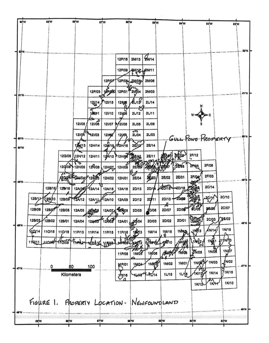
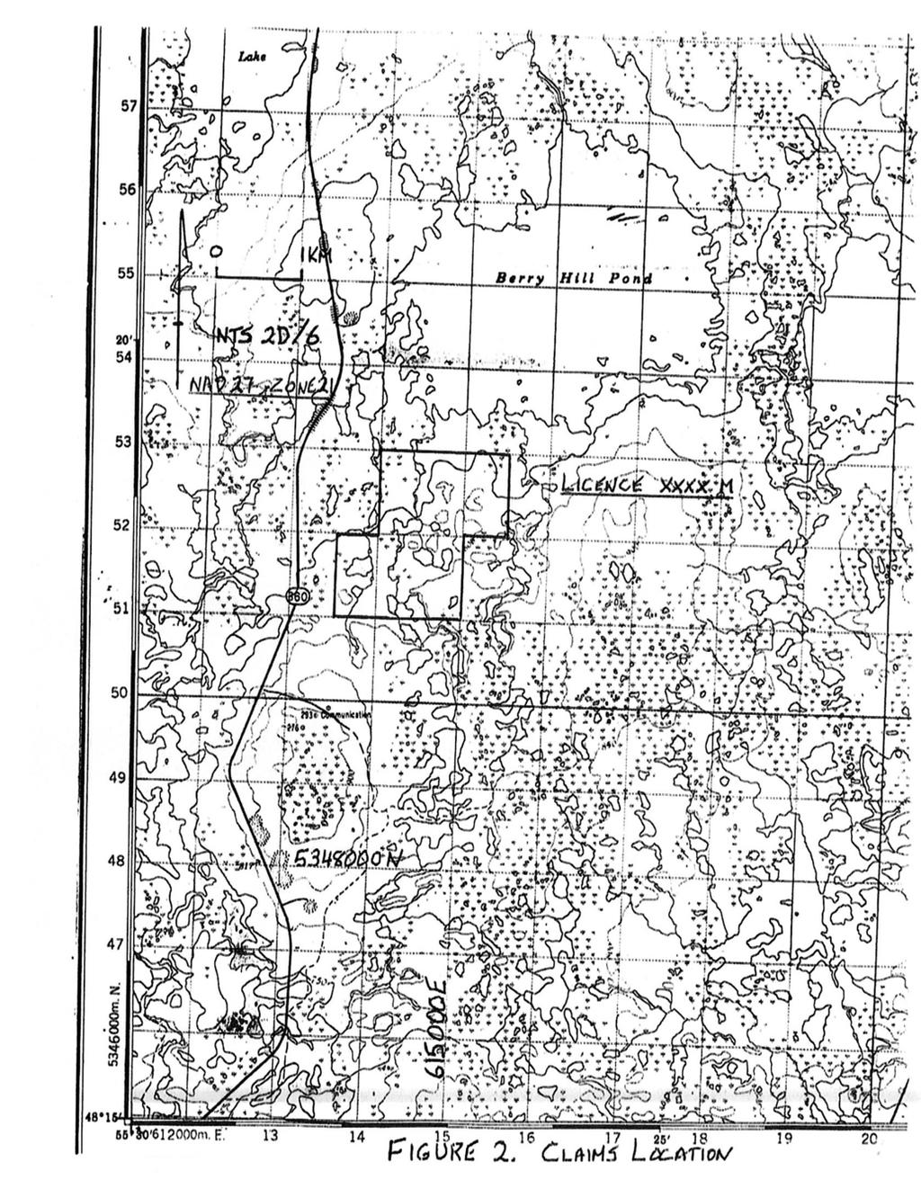
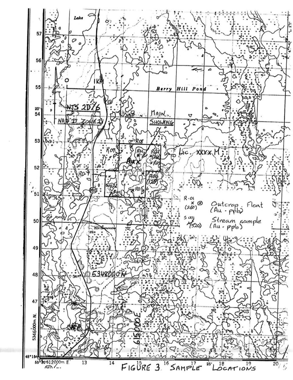
3 Table of Contents Treat this page as a general outline, and modify as needed to suit your own report. Page # Introduction 1 Location and Access 1 Previous Work 1 Geology and Mineralization 1 Current Work Program 4 Prospecting 4 etc. Results 4 Conclusion and Recommendations 4 References 7 List of Figures Figure 1. Property Location - Newfoundland 2 Figure 2. Claims Location Map 3 Figure 3. Rock and Stream Sample Locations 5 Figure 4. Grid and Soil Sample Locations 6 List of Appendices Appendix 1. Sample Descriptions Appendix 2. Assay Certificates Appendix 3. Personnel and Contractors Appendix 4. Statement of Expenditures pages pages 1 page 1 page
4 Introduction [General statement to start. Where your claims are, why staked, what this report is about] The Gull Pond property consists of? claims in? licences, located in central Newfoundland. The property was staked in 2003 for its gold and base-metal potential, and covers (anomalies? showing?). This report describes exploration work carried out on the property in Location and Access [Typical location stuff. Modify as needed] The Gull Pond property is located in NTS map area?, about? kilometres south of the town of (name) in central Newfoundland (Figure 1). A paved road (Route? ) passes about? kilometres from the western boundary of the property (Figure 2). Further access may be obtained from logging roads/quad trails? float plane or helicopter? (if necessary). Previous Work [This is a typical example of previous work. You can find reports of this type at the Department of Natural Resources (Norm Mercer - ( ). Companies and details will vary and should be changed accordingly. Many properties don=t have any work. It=s a good idea to plot the better results from previous work on your own maps, but remember to show the source - (e.g., Jones, 1986)] Previous work on the property was conducted by Noranda from 1986 to 1988 and included stream and till sampling, line-cutting, mapping and prospecting, magnetic and VLF-EM surveys and diamond drilling (Jones, 1986) (see page 7). Three holes were drilled for a total of? metres. The best results were 4.5 g/mt gold in grab samples and 1.3 g/mt gold over 1.0 m in drill core (Jones, 1988). Several gold anomalies (up to 500 ppb Au) discovered by till sampling have not been explained. Reference this work if possible, and definitely if you quote results. The present licence holder conducted reconnaissance prospecting and rock sampling in 2003 (Smith, 2003). Several anomalies up to? ppm copper and? ppb gold were obtained, and follow up work was recommended. Geology and Mineralization [This section is not essential, but may help to promote your property to a company, if that=s your intent. You can get this information from the Department of Natural Resources (see back page). The Gull Pond Property is underlain by sandstone, siltstone and shale of the Ordovician Davidsville Group. These are intruded locally by small plugs of gabbro, which in places are mineralized with pyrite, arsenopyrite and gold. The Gull Pond Showing, discovered by the author in 2003, consists of quartz veins hosted in gabbro, and has returned gold values up to 1.3 g/t from grab samples (Smith, 2003). Recent exploration by a number of companies in this area has focused on veinhosted gold mineralization associated with large-scale structures. Note: this type of statement should only be used if you are sure of your facts.58 1
5 2
6 3
7 Prospecting, 2004 [Typical example of your present work. Details will vary, and should be changed accordingly. Describe as best you can what you saw, and how you did things ] Prospecting on the Gull Pond property was conducted in [month(s), year]. Stream samples were collected on a 200 metre spacing in most brooks. Prospecting traverses were done over most of the property, and mineralized outcrops, quartz veins or float were sampled wherever possible. Outcrop is found mainly on hills to the northeast and in brooks. One rusty outcrop and several float with about 1% pyrite and chalcopyrite were found in the north part of the licence (samples R01, R02 - Figure 3). Flag and compass soil sample lines were placed at 100 metre spacing over the main showing. A hand-held GPS was used for location control. A total of? stream samples,? soil samples and? rock samples were collected. Sample locations are shown on Figures 3 and 4. Samples were sent to? (laboratory) of? (town),? (province) and analysed for gold and 9 additional elements. A list of sample descriptions is in Appendix 1 and assay certificates are in Appendix 2. Personnel and expenditures for the work are listed in appendices 3 and 4. Results [Describe your results: emphasize showings, anomalies (if any) - where? what kind (rock? soil?) how high? Details will vary, and should be changed accordingly. Always note showings, anomalies, etc., on maps and in text. Note: You may need to enlarge the map or use more than one to show all samples. Use different symbols for different sample types (rock, soil, stream)]. Results show that stream sediment anomalies with up to? ppm copper and? ppb gold are located in a small brook, on the west side of the licence (see Figure 3). Anomalous rock samples of up to? ppb gold were obtained from outcrop and float near the main showing (Figure 3). Several isolated anomalies in copper and gold were also noted in soil (Figure 4). Conclusions and Recommendations [General outline of what to do next. Build on previous results, more work on showings/anomalies, etc.] Recent sampling and previous work by Noranda has revealed anomalous copper and gold in stream and rock samples on the Gull Pond Property. It is recommended that detailed prospecting is performed to follow up on the stream anomalies. A grid should be cut over the main showing and detailed prospecting and soil sampling at 100 by 25 metre spacing should be conducted. Trenching and/or diamond drilling may be required, depending on results. Respectfully Submitted, (Signed) John B. Smith Prospector (Date) 4
8 5
9 6
10 References [List reports you have researched (if any) at the Department of Natural Resources. List your own work, if any.] Jones, A.A., 1986: Report on prospecting, geochemical and geophysical surveys, Gull Pond area. Unpublished report for Noranda Exploration Company Limited. (Newfoundland and Labrador Geological Survey, Assessment File 002D/????, xx pages) Jones, A.A., 1988: Report on diamond drilling, Gull Pond area. Unpublished report for Noranda Exploration Company Limited. (Newfoundland and Labrador Geological Survey, Assessment File 002D/????, xx pages) Smith, J.B., 2003: First year (2003) assessment report on prospecting, Licence????M, Gull Pond Property, NTS 2D/06, Newfoundland. Unpublished report for? (Licence holder). (If known - Newfoundland and Labrador Geological Survey, Assessment File 002D/????, xx pages) 7
11 Appendix 1. List of Sample Descriptions Providing accurate locations for samples, grids, trenches and drill holes is one of the most important parts of any assessment report. Inaccurate plotting may result in considerable waste of time and money for you and others. Furthermore, a potential optioner and/or joint venture partner will not be impressed if they are unable to relocate your samples, or reproduce your results. Rocks Sample # UTM east UTM north Description R01 R metre quartz float, minor pyrite Rusty outcrop, silicified, pyrite, trace chalcopyrite etc. py = pyrite, chalco = chalcopyrite Streams Sample # UTM east UTM north Comment S001 some quartz boulders in stream bed S002 etc. Soils Sample # Line Station UTM east UTM north Description SL N 0+00 W red-brown, sandy SL301 A 1+00 W grey, clay-rich SL302 A 2+00 E red-brown etc. All U.T.M. coordinates in NAD 27 for Zone 21U, NTS 2D/06 Create your own series of sample numbers. Use different letter codes or numbering series for different sample types, to keep them separate, but try not to use too many different codes for the same property since it may cause confusion.
12 Appendix 2. Assay Certificates [Always submit clear (not fax copies) signed (not printed from spreadsheet) copies (not originals). Do not enlarge, show at original size. Do not use a highlighter on original assay certificates.]
13 Appendix 3. Personnel and Contractors Personnel Name Residence Daily rate Activity Work Days John B. Smith Town, NL $ Prospecting 19 $ Report preparation 2 TOTAL 21 Contractors Eastern Analytical Limited Springdale, NL Assays
14 Appendix 4. Statement of Expenditures Add only legitimate assessment expenditures, and quote units where appropriate (e.g., xx $xx.xx /sample). Do not claim promotional activities (e.g., trips to CIM or PDA) or property visits by government geologists. Site visits by other company representatives are acceptable, but you must show their sample locations and assay certificates and copies of any correspondence describing the visit. Remember that an individual may only claim $ per day when working on his/her own claims (Regulation 53), but may charge up to 15% for overhead to cover phone/fax bills and the like. Receipts and copies of invoices are not required for assessment reports unless specifically requested. Prospecting 19 $100/day $1, Report preparation 2 $100/day Analytical Charges xx $xx.xx /sample Truck rental 4 $50/day Quad rental 4 $40/day Gas and meals Subtotal 3, Overhead 15% TOTAL $ 4, If more than one licence is being reported on, you must provide a breakdown of the expenditures by licence, i.e., repeat the above for each licence. A summary listing is also useful. Licence????M $?,???.?? Licence????M $?,???.?? Total $4,566.08
15 CHECKLIST FOR MAPS Wherever appropriate, all maps should have the following: - A metric bar scale and astronomic north arrow. - The NTS sheet(s), NAD and Zone. These can be found on any standard claim or topo map. - The licence boundaries (or a general location on a province-scale map) and licence number. - UTM coordinates for all property-scale location maps (claim, sample, grid, etc.). At least two fullylabeled northings and eastings should appear on each map. - A legend and list of symbols for all items used. - Make sure all sample numbers are legible, and match those shown on assay certificates. - Digital files should be submitted with all multi-colored maps. To avoid this, use symbols instead of colours. -Date of Preparation
16 For help in the following areas, please contact: Legislation, staking and licence information Jim Hinchey - Manager, Mineral Rights Phone (709) ; Fax (709) jimhinchey@gov.nl.ca Assessment report guidelines and suggestions Andrea Mills Geologist, Mineral Rights Phone (709) ; Fax (709) andreamills@gov.nl.ca Phil Saunders - Geologist, Exploration Monitoring Phone (709) ; Fax (709) philsaunders@gov.nl.ca Assessment files, government data and general information Phil Saunders - Mineral Exploration Consultant Phone (709) ; Fax (709) philsaunders@gov.nl.ca Matty Mitchell Prospectors Resource Room Pat O=Neill - Geologist, Matty Mitchell Room Phone: (709) ; Fax: (709) matty@gov.nl.ca Prospectors Assistance Program Justin Lake - Geologist, Prospectors Assistance Program Phone: (709) ; Fax: (709) justinwlake@gov.nl.ca
SECOND and THIRD YEAR ASSESSMENT REPORT PROSPECTING LICENCE M, ROCK CUT PROPERTY, NTS 1N/12, NEWFOUNDLAND. ROY FRENCH (licence holder )
") SECOND and THIRD YEAR ASSESSMENT REPORT Of PROSPECTING On LICENCE 013704M, ROCK CUT PROPERTY, NTS 1N/12, NEWFOUNDLAND. By ROY FRENCH (licence holder ) Work Conducted: Sept. 17, 2008 Nov. 03, 2009 Total
SECOND and THIRD YEAR ASSESSMENT REPORT Of PROSPECTING On LICENCE 013704M, ROCK CUT PROPERTY, NTS 1N/12, NEWFOUNDLAND. By ROY FRENCH (licence holder ) Work Conducted: Sept. 17, 2008 Nov. 03, 2009 Total
%+ '$# $) %, %*$ " $ $ ' %' !()'-!" %( %"%! " *'+ - % %$! $)! " $)!" !$ ' "! )( ! $ '%& ')- % % "!#( (( ((# $) ' ) ((* & *# ' % %"*# ( !!
 %, %*$ $ $ ' %' !()'-! %( %%! *'+ - % %$! $)! $)! !$ ' ! )( ! $ '%& ')- % % !#( (( ((# $) ' ) ((* & *# ' % %*# ( !!") 001L/14/0218 First Year Assessment Report of Prospecting, Rock and Stream Sediment Sampling On Licence 18880M, NTS 1L/14 Burin Peninsula Newfoundland and Labrador Submitted by: Keith Kelloway Work year:
001L/14/0218 First Year Assessment Report of Prospecting, Rock and Stream Sediment Sampling On Licence 18880M, NTS 1L/14 Burin Peninsula Newfoundland and Labrador Submitted by: Keith Kelloway Work year:
First Year Assessment Report: Report on Prospecting, Rock and Soil Sampling Carried Out From September/2012 to December/2012.
 First Year Assessment Report: Report on Prospecting, Rock and Soil Sampling Carried Out From September/2012 to December/2012 on the Clarkes Pond Property Licence 020334M Northwest Gander River,Central
First Year assessment Report on Prospecting and Rock sampling, King George property, License M NTS 12A/05 Newfoundland and Labrador.
 First Year assessment Report on Prospecting and Rock sampling, King George property, License 016679M NTS 12A/05 Newfoundland and Labrador. Submitted by Shawn Rose For Shawn Rose January 2011 Work year
FIRST YEAR ASSESSMENT REPORT ON THE HAMMERDOWN SOUTH PROPERTY KING S POINT AREA, NEWFOUNDLAND
 FIRST YEAR ASSESSMENT REPORT ON THE HAMMERDOWN SOUTH PROPERTY KING S POINT AREA, NEWFOUNDLAND Licenses: 017558M, 017559M, 017560M and 017561M NTS Mapsheets: 012H/08 and 012H/09 Garry Fraser 66a Frontenac
Compilation Report Hawke Hill South. Licence No M NTS 01N/06. Newfoundland and Labrador. Submitted by Gordon E. Cooper and Kevin P.
 Compilation Report 2010 Hawke Hill South Licence No. 017282M NTS 01N/06 Newfoundland and Labrador Submitted by Gordon E. Cooper and Kevin P. Ryan For Kevin P. Ryan (Licence holder) January, 2011 Work Year:
ANTLER GOLD EXPLORATION UPDATE, WILDING LAKE GOLD PROJECT, NEWFOUNDLAND
 ANTLER GOLD EXPLORATION UPDATE, WILDING LAKE GOLD PROJECT, NEWFOUNDLAND HALIFAX, NOVA SCOTIA (CNW May 10, 2018) Antler Gold Inc. ( Antler ) (TSX-V:ANTL) is pleased to provide an update on its upcoming
ASSESSMENT REPORT ON THE PEAVINE PROJECT. DGW & Associates # Alberni Street, Vancouver, British Columbia, V6E 4V2
 ASSESSMENT REPORT ON THE PEAVINE PROJECT KAMLOOPS MINING DIVISION BRITISH COLUMBIA NTS 082M 12 Latitude 51 36' 19.0"North -- Longitude --119 47' 27.0"West UTM Zone 11, NAD 83 5720827N 306744E Prepared
Guidelines for the Form of Reports and Illustrations
 Guidelines for the Form of Reports and Illustrations as Prescribed by the Minister as per Section 55(2) of The Consolidated Newfoundland and Labrador Regulation 1143/96 (As Amended) (Revised - December,
ANTLER GOLD DRILLS GRAMS PER TONNE GOLD OVER 5.35 METRES AT THE WILDING LAKE GOLD PROJECT, NEWFOUNDLAND
 ANTLER GOLD DRILLS 10.01 GRAMS PER TONNE GOLD OVER 5.35 METRES AT THE WILDING LAKE GOLD PROJECT, NEWFOUNDLAND HALIFAX, NOVA SCOTIA (CNW December 13 th, 2017) Antler Gold Inc. ( Antler ) (TSX- V:ANTL) is
2010 ASSESSMENT REPORT ON PROSPECTING AND ROCK SAMPLING MICHIKAMATS PROPERTY
 2010 ASSESSMENT REPORT ON PROSPECTING AND ROCK SAMPLING MICHIKAMATS PROPERTY Licences no 017501M, 017505M, 017502M, 017503M, 017504M, 017507M, 017508M, 017509M, 017511M, 017512M, 017516M, 017500M and 017529M
for the Greenwood Mining Division, B.C. NTS 82E/7W Latitude 49' 27' W, Longitude 118' 5 Prepared by a= D. Dylan Watt, B.Sc.
 t. b LOGnO: 37~ -08 m. ACTIO#: for the AMP AMP 2 AMP 3 t AMP 4 CLAIMS Greenwood Mining Division, B.C. NTS 82E/7W Latitude 49' 27' W, Longitude 8' 5 %E c,w zc *& a w Prepared by a= -4c. D. Dylan Watt, B.Sc.
SIXTH SCHEDULE REPUBLIC OF SOUTH SUDAN MINISTRY OF PETROLEUM, MINING THE MINING (MINERAL TITLE) REGULATIONS 2015
 REGULATIONS 2015") SIXTH SCHEDULE REPUBLIC OF SOUTH SUDAN MINISTRY OF PETROLEUM, MINING THE MINING ACT, 2012 THE MINING (MINERAL TITLE) REGULATIONS 2015 Guidelines should be prepared by the Directorate of Mineral Development
SIXTH SCHEDULE REPUBLIC OF SOUTH SUDAN MINISTRY OF PETROLEUM, MINING THE MINING ACT, 2012 THE MINING (MINERAL TITLE) REGULATIONS 2015 Guidelines should be prepared by the Directorate of Mineral Development
PROSPECTING REPORT THE WALLACE CLAIM OMENICA MINING DIVISION. 54" x6" 3.d d. for. Reako Exlorat ions Ltd. Wallace Rev. C.G.
 PROSPECTING REPORT ON THE WALLACE CLAIM OMENICA MINING DIVISION 54"44 14 1x6" 3.d d by David A. Howard P.Eng. for Reako Exlorat ions Ltd. Claim Locat ion Wallace Rev. C.G. #1560 Dome Mountain Area 9 3
For personal use only
 ASX Announcement 2 June 2015 STRONG GOLD ANOMALIES DEFINED AT ST PIERRE Soil sampling defines two strong gold-in-soil anomalies within the St Pierre exploration licence. Soil sampling conducted to follow
CONTENTS. Location, Access and History...6. Tenure Status and Geology Regional Andy Property Geology Map...9
 TYPE OFWORK IN THIS REPORT EXTENT OF WORK (rn METRTC UNITS) ON WHICH CLAIMS PROJECT COSTS APPORTIONED (incl. support) GEOLOGICAL (scale, area) Ground, mapping Photo interpretation GEOPHYSICAL (line-kilometres)
DRILLING EXPANDS SIGNIFICANT COPPER-GOLD PORPHYRY SYSTEM AT IVANHOE S KHARMAGTAI PROJECT IN MONGOLIA
 For immediate release November 26, 2002 DRILLING EXPANDS SIGNIFICANT COPPER-GOLD PORPHYRY SYSTEM AT IVANHOE S KHARMAGTAI PROJECT IN MONGOLIA ULAANBAATAR, MONGOLIA Ivanhoe Mines Chairman Robert Friedland
FIRST 2 DRILL HOLES AT NAKRU-2 PROSPECT BOTH INTERSECT SIGNIFICANT HIGHER GRADE COPPER MINERALISATION
 ADDRESS PHONE PO Box 6965 +61(07) 5592 1001 Gold Coast Mail Centre FAX Qld 9726 Australia +61 (07) 5592 1011 EMAIL ABN 54 126 490 855 info@coppermoly.com.au WEBSITE www.coppermoly.com.au ASX Announcement
GEOLOGICAL MAPPING REPORT ON THE ASH MINERAL CLAIM OSOYOOS MINING DIVISION ASHNOLA RIVER MAP SHEET NTS M092,H019 MCBRIDE CREEK AREA, ASHNOLA RIVER,
 GEOLOGICAL MAPPING REPORT ON THE ASH MINERAL CLAIM OSOYOOS MINING DIVISION ASHNOLA RIVER MAP SHEET NTS M092,H019 LATITUDE 49 o O6, LONGITUDE 120 o 22 MCBRIDE CREEK AREA, ASHNOLA RIVER, KEREMEOS, B.C. CANADA
CHAMPION IRON REPORTS EXPLORATION RESULTS AT POWDERHORN PROJECT, NEWFOUNDLAND
 PRESS RELEASE CHAMPION IRON REPORTS EXPLORATION RESULTS AT POWDERHORN PROJECT, NEWFOUNDLAND Confirmed Continuity of High-Grade Zinc Zone and Addition of Gold to the Expanded Copper Zone Montreal, March
Spruce Ridge Resources Ltd Leslie Road West, Puslinch, ON N0B 2J0 Telephone: (519) , Fax: (519)
 , Fax: (519)") Spruce Ridge Resources Ltd. 7735 Leslie Road West, Puslinch, ON N0B 2J0 Telephone: (519) 822-5904, Fax: (519) 823-5090 PRESS RELEASE 2018-07 July 24, 2018 Spruce Ridge Resources Provides Update on the
Spruce Ridge Resources Ltd. 7735 Leslie Road West, Puslinch, ON N0B 2J0 Telephone: (519) 822-5904, Fax: (519) 823-5090 PRESS RELEASE 2018-07 July 24, 2018 Spruce Ridge Resources Provides Update on the
%+ '$# $) %, %*$ " $ $ ' %' !()'-!" %( %"%! " *'+ - % %$! $)! " $)!" !$ ' "! )( ! $ '%& ')- % % "!#( (( ((# $) ' ) ((* & *# ' % %"*# ( !!
 %, %*$ $ $ ' %' !()'-! %( %%! *'+ - % %$! $)! $)! !$ ' ! )( ! $ '%& ')- % % !#( (( ((# $) ' ) ((* & *# ' % %*# ( !!") 023H/05/0158 Assessment Report 2014 2nd year assessment report on prospecting Lake Sed., rock and soil sampling, Misty lake, property, Labrador. NTS: 23H/05 Licence # 020885M------ 6 Claims Licence # 020991M------
023H/05/0158 Assessment Report 2014 2nd year assessment report on prospecting Lake Sed., rock and soil sampling, Misty lake, property, Labrador. NTS: 23H/05 Licence # 020885M------ 6 Claims Licence # 020991M------
Lat. 52' 43' N Long ' W
 &A exploration ltd MINING ENGINEERING GEOLOGY- GEOPHYSICS 4570 HOSKINS ROAD, NORTH VANCOUVER, 6. C. TELEPHONE (804) 985,7921 V7K 2R1 GEOLOGICAL AND GEOCHEMICAL REPORT on the BLUE CLAIMS Cariboo Mining
FOURTH YEAR ASSESSMENT REPORT PROSPECTING AND GEOCHEMICAL INVESTIGATIONS LICENCE M SITUATED WITHIN NTS MAP SHEET 02E/02 BRINKS POND CENTRAL
 FOURTH YEAR ASSESSMENT REPORT PROSPECTING AND GEOCHEMICAL INVESTIGATIONS LICENCE 016249M SITUATED WITHIN NTS MAP SHEET 02E/02 BRINKS POND CENTRAL NEWFOUNDLAND I TABLE OF CONTENTS 1:0 INTRODUCTION PAGE
PROSPECTORS ASSISTANCE PROGRAM MINISTRY OF ENERGY AND MINES
 BRITISH COLUMBIA PROSPECTORS ASSISTANCE PROGRAM MINISTRY OF ENERGY AND MINES GEOLOGICAL SURVEY BRANCH PROGRAM YEAR: 1999/2000 REPORT #: PAP 99-l 6 NAME: KIM ANSCHETZ PROSPECTORS TlEPORT on the 99 LOUIS
DiaMine Exploration Inc. Pickle Lake Option Property
 DiaMine Exploration Inc. Pickle Lake Option Property Rock Sampling Program and Field Observations Claims 4249174, 4249175, 4249176 and 4249177, Kapkichi Lake Area (G-2081) And Claims 4249178, 4249179 and
DÉCOUVERTE Positioned for Discovery in James Bay, Quebec. Investor Presentation, January 2018 by Danae Voormeij, MSc, PGeo
 DÉCOUVERTE Positioned for Discovery in James Bay, Quebec Investor Presentation, January 2018 by Danae Voormeij, MSc, PGeo Location Maps and Infrastructure Location: Durango Resources 100% owned Découverte
INV METALS ANNOUNCES DRILL RESULTS AT LOMA LARGA AND INITIAL PROSPECTING RESULTS ON NEW REGIONAL PROPERTIES
 INV METALS ANNOUNCES DRILL RESULTS AT LOMA LARGA AND INITIAL PROSPECTING RESULTS ON NEW REGIONAL PROPERTIES TORONTO, ON September 18, 2017 INV Metals ( INV Metals or Company ) (TSX: INV) is very pleased
For personal use only
 ASX ANNOUNCEMENT ACN 123 567 073 3 July 2014 NEW FRASER RANGE PROJECT AREA AT KITCHENER New 100%-owned exploration licence application covers 203km 2, situated on the Fraser Range Gravity High Enterprise
Grassroots Exploration for Gold in Labrador
 Grassroots Exploration for Gold in Labrador Roger Moss, Nikos Explorations Ltd., Shawn Ryan, RyanWood Exploration, John Clarke, GroundTruth Exploration. Mineral Resources Review November 1 st -4 th 2017
BALFOUR MINING LTD. (N.P.L.) HAM GROUP 92-P-6, CLINTON M. D.8 B. C. Lat 51 17'N, GEOCHEMICAL REPORT. V. CUKOR, P. Eng.
 HAM GROUP 92-P-6, CLINTON M. D.8 B. C. Lat 51 17'N, GEOCHEMICAL REPORT. V. CUKOR, P. Eng.") 34q '7 BALFOUR MINING LTD. (N.P.L.) HAM GROUP 92-P-6, CLINTON M. D.8 B. C. Lat 51 17'N, Long 12lo14'W GEOCHEMICAL REPORT, V. CUKOR, P. Eng. January 31, 1972 TABLE OF CONTENTS 1. INTRODUCTION 2. PROPERTY,
34q '7 BALFOUR MINING LTD. (N.P.L.) HAM GROUP 92-P-6, CLINTON M. D.8 B. C. Lat 51 17'N, Long 12lo14'W GEOCHEMICAL REPORT, V. CUKOR, P. Eng. January 31, 1972 TABLE OF CONTENTS 1. INTRODUCTION 2. PROPERTY,
COMBINATION OF MMI AND ENZYME LEACH METHODS IN EXPLORATION FOR GOLD IN AN AREA OF THE CANADIAN SHIELD COVERED WITH GLACIAL SEDIMENTS: A CASE STUDY
 COMBINATION OF MMI AND ENZYME LEACH METHODS IN EXPLORATION FOR GOLD IN AN AREA OF THE CANADIAN SHIELD COVERED WITH GLACIAL SEDIMENTS: A CASE STUDY Nadia Yavorskaya 450 Bonner Ave., Winnipeg, MB, Canada
for the Greenwood Mining Division, B.C. NTS 82E/7W 29' W, Longitude 118' 53' N Prepared by D. Dylan Watt, B.Sc.
 for the FltE NO: u VOLT 1, VOLT 2, VOLT 3, & VOLT 4 CLAIMS Greenwood Mining Division, B.C. NTS 82E/7W Latitude 49' 29' W, Longitude 118' 53' N Prepared by D. Dylan Watt, B.Sc. #309-1996 Trutch Street Vancouver,
ASSESSMENT REPORT. HL1 Project, License 06172M (1st year), Newfoundland NTS 2D/05: Report on Prospecting and Rock Sampling For Larry Quinlan
, Newfoundland NTS 2D/05: Report on Prospecting and Rock Sampling For Larry Quinlan") ASSESSMENT REPORT HL1 Project, License 06172M (1st year), Newfoundland NTS 2D/05: Report on Prospecting and Rock Sampling For Larry Quinlan Work conducted from June, 2009 to April, 2010 Total Expenditures:
ASSESSMENT REPORT HL1 Project, License 06172M (1st year), Newfoundland NTS 2D/05: Report on Prospecting and Rock Sampling For Larry Quinlan Work conducted from June, 2009 to April, 2010 Total Expenditures:
POTENTIAL OF THE DONGWE COPPER GOLD PROJECT
 POTENTIAL OF THE DONGWE COPPER GOLD PROJECT By Nathan Sabao, P.Geo. September 2015 1 TABLE OF CONTENTS Page 1.0 EXECUTIVE SUMMARY 1 2.0 LOCATION 2 3.0 ACCESS 2 4.0 GEOLOGY 3 5.0 PREVIOUS DRILLING 5 6.0
ASX Announcement. 28 January Drill results indicate large Porphyry Copper Gold System at Peenam
 ASX Announcement 28 January 2010 Drill results indicate large Porphyry Copper Gold System at Peenam Highlights: 270 metres of visible copper (gold) mineralisation in first diamond core hole at Peenam Prospect
GEOCHEMICAL REPORT LAST LINK GROUP TEXADA ISLAND NANAIMO MINING DIVISION
 I GEOCHEMICAL REPORT LAST LINK GROUP TEXADA ISLAND NANAIMO MINING DIVISION -1- PROSPECTING & GEOCHEMICAL SOIL SURVEY FOR GOLD On the Last Link Group of Claims North End of Texada Island Nanaimo Mining
RECONNAISSANCE GEOCHEMICAL SURVEY
 RECONNAISSANCE GEOCHEMICAL SURVEY LEGAL, RITA, LOUISE FR. (CHAPLEAU GROUP) REVERTED CROWN GRANTS CHAPLEAU CREEK AREAJ, SLOC& MINING DIVISION 82 F/11W Lat: 49'44" Long: 117"22'W MINERAL RESOURCES BRANCH
UNION MINIERE EXPLORATIONS AND MINING CORPORATION LIMITED ASSESSMENT REPORT ON FITINAT MINERAL CLAIM. Alberni Mining Division Record No.
 M F )( UNION MINIERE EXPLORATIONS AND MINING CORPORATION LIMITED Suite 200, 4299 Canada Way, Burnaby, B.C. V5G 1 H4 Telephone (604) 437-9491 ASSESSMENT REPORT ON GEOCHEMICAL SOIL SURVEYS AND ROCKSAMPLING
Narrow High-Grade Gold and Long Low-Grade Porphyry Gold and Copper-Gold Intercepts at Bulago
 CONTACTS PHONE EMAIL PO Box 52 +61 (08) 9295 0388 info@frontierresources.com.au West Perth FAX WEBSITE WA 6872 Australia +61 (08) 9295 3480 www.frontierresources.com.au ASX Limited Company Announcements
Anthill Resources Yukon - An Update on the Einarson Project
 Anthill Resources Yukon - An Update on the Einarson Project The Eastern Extension of a Carlin-type Gold Trend in the Selwyn Basin Anthill Resources Ltd Yukon Claim Holdings Over 2400 km 2 Property Location
Technical Standards for Reporting Assessment Work Under the Provisions of the Mining Act R.S.O. 1990
 Technical Standards for Reporting Assessment Work Under the Provisions of the Mining Act R.S.O. 1990 March 5, 2018 CONTENTS INTRODUCTION WORK TYPES AND ASSOCIATED WORK TYPES 1. GRASS ROOTS PROSPECTING
Great Atlantic Rock Samples Return up to 5.8 oz. / ton Gold Golden Promise Property in Central Newfoundland
 Great Atlantic Rock Samples Return up to 5.8 oz. / ton Gold Golden Promise Property in Central Newfoundland FOCUSED ON EXPLORING ATLANTIC CANADA (TSXV : GR) (FRA: PH01) VANCOUVER, British Columbia August
%+ '$# $) %, %*$ " $ $ ' %' !()'-!" %( %"%! " *'+ - % %$! $)! " $)!" !$ ' "! )( ! $ '%& ')- % % "!#( (( ((# $) ' ) ((* & *# ' % %"*# ( !!
 %, %*$ $ $ ' %' !()'-! %( %%! *'+ - % %$! $)! $)! !$ ' ! )( ! $ '%& ')- % % !#( (( ((# $) ' ) ((* & *# ' % %*# ( !!") 001N/11/0964 Third Year Assessment Report for Licence 20850M Of Prospecting Activity On the Red Rock Property NTS 1N/11 Brigus, Newfoundland and Labrador Submitted by (License Holder) Jason White Work
001N/11/0964 Third Year Assessment Report for Licence 20850M Of Prospecting Activity On the Red Rock Property NTS 1N/11 Brigus, Newfoundland and Labrador Submitted by (License Holder) Jason White Work
490 20' 30" North Latitude ' 30" West Longitude
 _._.. I CONSULTING GEOLOGISTS 605-602 WEST HASTINGS STREET, VANCOUVER, B.C. V6B 1P2 TELEPHONE: (604) 689-5533 6 I F: ASSESSMENT REPORT ON THE PATSY 1 MINERAL CLAIM ' '?%2% I WHISTLE CREEK, HEDLEY ARE L-l-
The Cobalt Rainbow. Airborne geophysical maps show that a north trending aeromagnetic high suggests further undiscovered mineralisation.
 The Cobalt Rainbow The property is located on Greenstone Creek, approximately 4.8 kilometres south west of the creek mouth. The property is located about 24 km due west of Campbell River, in the east-central
ASSESSMENT REPORT TITLE PAGE AND SUMMARY
 ASSESSMENT REPORT TITLE PAGE AND SUMMARY TITLE OF REPORT: 2016 Prospecting Report Midas Claim TOTAL COST: $314.61 AUTHOR(S): Giacomo Grassi SIGNATURE(S): NOTICE OF WORK PERMIT NUMBER(S)/DATE(S): STATEMENT
ASX / MEDIA RELEASE 6 MAY MILE SILVER-LEAD-ZINC DISCOVERY; HIGH GRADE SILVER-GOLD IN ROCK CHIPS AT RUBY SILVER
 ASX / MEDIA RELEASE 6 MAY 2011 4-MILE SILVER-LEAD-ZINC DISCOVERY; HIGH GRADE SILVER-GOLD IN ROCK CHIPS AT RUBY SILVER Highlights: Silver-lead-zinc discovery at 4-Mile; mineralisation intersected in all
RECONNAISSANCE AND SOIL GEOCHEMICAL SAMPLING REPORT PORCUPINE MINING DIVISION ON CLAIM , LANGMUIR TOWNSHIP
 RECONNAISSANCE AND SOIL GEOCHEMICAL SAMPLING REPORT ON CLAIM 1224499, LANGMUIR TOWNSHIP PORCUPINE MINING DIVISION CLM 1224499 NTS: 42A/06 Author: William Randall, P.Geo 1 Table of Contents Work Performed
Report of Gridding and Magnetic Surveys. On the. Munro Property. Munro and Beatty Townships, Ontario. Larder Lake Mining Division
 Report of Gridding and Magnetic Surveys On the Munro Property Munro and Beatty Townships, Ontario Larder Lake Mining Division Claims: 39 4244 For Big Red Diamond Corporation October 3, 2 Timmins, Ontario
NEW COBAR-STYLE COPPER DISCOVERY IN NSW
 ASX / MEDIA RELEASE 2 AUGUST 2011 NEW COBAR-STYLE COPPER DISCOVERY IN NSW Broad zone of copper-polymetallic mineralisation intersected at 4-Mile prospect Highlights: Wide zone of copper-silver-gold-lead-zinc
102 metres strike length averaging 32.62g/t Gold extends overall surface vein sampling to date to 726 metres strike length averaging 24.
 ASX ANNOUNCEMENT / MEDIA RELEASE ASX:ABU 8 th February 2012 Old Pirate Phase 4 Longitudinal Trenching Results for veins on the Western Limb Lodes 102 metres strike length averaging 32.62g/t Gold extends
DISCOVERY OF MINERALISED PORPHYRY & MAGNETITE-COPPER-GOLD AT KAMARANGAN
 MEDUSA MINING LIMITED ABN: 60 099 377 849 Unit 7, 11 Preston Street Como WA 6152 PO Box 860 Canning Bridge WA 6153 Telephone: +618-9367 0601 Facsimile: +618-9367 0602 Email: admin@medusamining.com.au Internet:
%+ '$# $) %, %*$ " $ $ ' %' !()'-!" %( %"%! " *'+ - % %$! $)! " $)!" !$ ' "! )( ! $ '%& ')- % % "!#( (( ((# $) ' ) ((* & *# ' % %"*# ( !!
 %, %*$ $ $ ' %' !()'-! %( %%! *'+ - % %$! $)! $)! !$ ' ! )( ! $ '%& ')- % % !#( (( ((# $) ' ) ((* & *# ' % %*# ( !!") 013B/11/0045 2 nd year assessment report on Prospecting, and Geophysics Crooks Lake Property, License # 019380M Newfoundland and Labrador. Submitted by / for Jeffrey Martin Dec 8, 2013 Work year 2 Total
013B/11/0045 2 nd year assessment report on Prospecting, and Geophysics Crooks Lake Property, License # 019380M Newfoundland and Labrador. Submitted by / for Jeffrey Martin Dec 8, 2013 Work year 2 Total
%+ '$# $) %, %*$ " $ $ ' %' !()'-!" %( %"%! " *'+ - % %$! $)! " $)!" !$ ' "! )( ! $ '%& ')- % % "!#( (( ((# $) ' ) ((* & *# ' % %"*# ( !!
 %, %*$ $ $ ' %' !()'-! %( %%! *'+ - % %$! $)! $)! !$ ' ! )( ! $ '%& ')- % % !#( (( ((# $) ' ) ((* & *# ' % %*# ( !!") 001L/14/0215 Seventh Year Assessment Report on Prospecting, Rock, Stream and Soil Sampling, and Radiometric Surveying Licence 10689M, NTS 1L14 Burin Peninsula, Newfoundland Submitted by: Keith Kelloway
001L/14/0215 Seventh Year Assessment Report on Prospecting, Rock, Stream and Soil Sampling, and Radiometric Surveying Licence 10689M, NTS 1L14 Burin Peninsula, Newfoundland Submitted by: Keith Kelloway
NT RESOURCES LIMITED QUARTERLY ACTIVITIES REPORT FOR THE PERIOD ENDED 30 JUNE 2010 ASX CODE: NTR
 NT RESOURCES LIMITED QUARTERLY ACTIVITIES REPORT FOR THE PERIOD ENDED 30 JUNE 2010 ASX CODE: NTR Activities Report Background NT Resources Limited ( NT Resources or the Company ) holds six granted Exploration
For personal use only
 INTEGRATED RESOURCES GROUP LIMITED REPORT ON ACTIVITIES, MARCH 2012 QUARTER HIGHLIGHTS Announcement of company transforming Maryborough Basin project acquisition, expected to be completed in June 2012.
Discovering Canadian Gold and Diamonds. Oxford Lake Project, Manitoba
 Discovering Canadian Gold and Diamonds Oxford Lake Project, Manitoba March 2016 Forward Looking Statement Certain statements contained in this presentation may contain forward-looking information within
1 CLAIMS GEOPHYSICAL REPORT ON BOYAL SITUATE NORTHEAST OF TILLICUM MOUNTAIN GOLD AREA BURTON - NAKUSP SIQCAEJ MINING DIVISION
 GEOPHYSICAL REPORT ON BOYAL 1 CLAIMS SITUATE NORTHEAST OF TILLICUM MOUNTAIN GOLD AREA BURTON - NAKUSP SIQCAEJ MINING DIVISION CONSULTING GEOLOGIST AUGUST 1983 VANCOUVER B *C INDEX INTRODUCTION ooa,.eoaaa.aaaoaaooaoa~ao~o
Montgomery Bedrock Geology 21d-Gowganda Formation: conglomerate, sandstone, siltstone, argillite
 Work Report 2014 Trenching Montgomery Township G-3303 Claim #4259384,4245818 Sault Ste. Marie Mining Division Michael & Yvon Gagne Montgomery Copper Property 1 P a g e 2 P a g e Montgomery Bedrock Geology
December 6th I960. President and Directors, Chipman Lake Mines Ltd. 25 King Street West, Toronto.
 OFFICE: EM, 3-3933 RES.: HU. 1-1265 "' Mfc 42A85NE0127 63.1089 GODFREY 010. D. President and Directors, Chipman Lake Mines Ltd. 25 King Street West, Toronto. December 6th I960 REPORT ON GEOPHYSICAL SURVEY
Forward Looking Statements
 Forward Looking Statements Except for the statements of historical fact contained herein, certain information presented constitutes "forward-looking statements" within the meaning of the United States
Tameapa Regional Geology
 Tameapa Project 1 Tameapa Regional Geology History San Francisco Mines of Mexico Ltd. (San Francisco), which completed an exploration program, including six drill holes (1,157 m) between 1956 and 1959.
EXPLORATION UPDATE. LACHLAN FOLD BELT and ALBANY FRASER MOBILE ZONE
 ABN: 30 068 263 098 Level 1, 37 Ord Street, West Perth WA 6005 Phone: +61 (0)8 9215 4444 Website: www.heronresources.com.au Email: heron@heronresouces.com.au ASX Release 28 November 2012 EXPLORATION UPDATE
ANTLER GOLD HIGHLIGHTS NEW GOLD-IN-SOIL ANOMALIES, CENTRAL NEWFOUNDLAND
 ANTLER GOLD HIGHLIGHTS NEW GOLD-IN-SOIL ANOMALIES, CENTRAL NEWFOUNDLAND HALIFAX, NOVA SCOTIA (CNW October 17, 2018) Antler Gold Inc. ( Antler ) (TSX- V:ANTL) is pleased to provide an update on its successful
GEOPACIFIC REPORTS HIGH GOLD VALUES IN AUGER SOIL SAMPLES FROM THE QALAU AND TATAIYA PROSPECTS, RAKI RAKI PROJECT,
 20 June 2008 Companies Announcement Office Via Electronic Lodgement GEOPACIFIC REPORTS HIGH GOLD VALUES IN AUGER SOIL SAMPLES FROM THE QALAU AND TATAIYA PROSPECTS, RAKI RAKI PROJECT, Fiji. (Geopacific
ASX Announcement. New economic gold results confirm Dave East as an exciting new discovery. Highlights. 4 July 2011
 4 July 2011 ASX Announcement New economic gold results confirm Dave East as an exciting new discovery Level 2, 9 Colin Street West Perth WA 6005 ABN 11 127 171 877 p (08) 9216 1000 f (08) 9481 7939 w www.predictivediscovery.com
RC drilling begins at Akoko Project marking commencement of 2010/11 exploration field season
 29 th October 2010 September December Quarterly 2010 Quarterly Report 2008 Report Highlights RC drilling begins at Akoko Project marking commencement of 2010/11 exploration field season Major drill programs
John A. Wakeford Noranda Exploration Co., Ltd, November 4, 1980 rinnnins, Ontario
 42CC1NEfc4e9 801101 ECHUM 010 " ' i-^y&sg?' '.. -.r. K;VW\\:.!^-*.]-^--'^-r-r^Pj^Q..-. ;,: v 1,;-'-,..- ^^-^^^^ysr-r^ijjfiv^jj. v -." ". '. ' "i - '' '. '':.;': s.'.ilv'., p...--'*l r-j@tw IP ^vt'.'v*:-^
TIGER GOLD EXPLORATION CORPORATION. Prospecting Over the HARKER HERITAGE PROPERTY AREA 10. Harker Township, Ontario
 PO Box 219, 14579 Government Road, Larder Lake, Ontario, P0K 1L0, Canada Phone (705) 643-2345 Fax (705) 643-2191 www.cxsltd.com TIGER GOLD EXPLORATION CORPORATION Prospecting Over the HARKER HERITAGE PROPERTY
Acquisition of Kilfoyle Project, Northern Territory
 ASX Announcement 31 May 2018 Level 1, 135 Fullarton Road Rose Park, SA 5067 Australia Telephone +61 (0) 8 8364 3188 Facsimile +61 (0) 8 8364 4288 info@pnxmetals.com.au www.pnxmetals.com.au Acquisition
NEW HAZELTON, OMINECA M.D.,
 PROSPECTING REPORT JUDI 1 TO 6 MINERAL CLAIMS NEW HAZELTON, OMINECA M.D., B.C. MAP 93M/4E, LAT. SS014'N, LONG. 127'33'W OWNED BY: A. L'ORSA ANTHONY L'ORSA Smithers, B.C. 21 February, 1981 TABLE OF CONTENTS
The MAPLE BAY PROJECT Copper Silver - Gold
 The MAPLE BAY PROJECT Copper Silver - Gold Good grade and tonnage potential within close proximity to Tidewater The Maple Bay Copper Silver Gold Project covers highly favourable geological host rocks of
We are committed to providing accessible customer service. If you need accessible formats or communications supports, please contact us.
 We are committed to providing accessible customer service. If you need accessible formats or communications supports, please contact us. Nous tenons à améliorer l accessibilité des services à la clientèle.
Saskatchewan s Mineral Resources Lesson: Exploring for Minerals in Saskatchewan: Stream Sediment and Soil Sampling
 Saskatchewan s Mineral Resources Lesson: Exploring for Minerals in Saskatchewan: Stream Sediment and Soil Sampling Overview In this activity, students use information from geochemical surveys (stream sediment
BLURTON CREEK NICKEL PROPERTY. (Minfile # 082LNW-039)
") 5489153 BLURTON CREEK NICKEL PROPERTY (Minfile # 082LNW-039) Mara Lake Area / Salmon Arm B.C NTS - 82L-11 (UTM 83/Z10, 357690E, 5614220N) Prepared by: Jim Cuttle, B.Sc., P.Geo. 86 Cloudburst Road Whistler,
5489153 BLURTON CREEK NICKEL PROPERTY (Minfile # 082LNW-039) Mara Lake Area / Salmon Arm B.C NTS - 82L-11 (UTM 83/Z10, 357690E, 5614220N) Prepared by: Jim Cuttle, B.Sc., P.Geo. 86 Cloudburst Road Whistler,
PROSPECTING Survey Over the AULD PROPERTY Auld Township, Ontario
 PO Box 219, 14579 Government Road, Larder Lake, Ontario, P0K 1L0, Canada Phone (705) 643-2345 Fax (705) 643-2191 www.cxsltd.com PROSPECTING Survey Over the AULD PROPERTY C Jason Ploeger, B.Sc, P.Geo August
FIRST YEAR ASSESSMENT REPORT PROSPECTING LICENCE 16512M MARYSTOWN AREA, BURIN PENINSULA NTS 1M/3
 FIRST YEAR ASSESSMENT REPORT OF PROSPECTING ON LICENCE 16512M MARYSTOWN AREA, BURIN PENINSULA NTS 1M/3 BY NATHANIEL NOEL MSc. FOR E. MICHELE NOEL MINERAL LICENCES: 16512 M WORK CONDUCTED: MID-SEPTEMBER
Maiden Kandia Gold Resource of 107,500 Ounces
 ASX RELEASE 5 th December 2011 Maiden Kandia Gold Resource of 107,500 Ounces Mineral Resource estimate for the Kandia prospect totals 3.3mt @ 1.0g/t gold for 107,500 ounces Resource outcrops at surface
ASSESSMENT REPORT TITLE PAGE AND SUMMARY
 ASSESSMENT REPORT TITLE PAGE AND SUMMARY TITLE OF REPORT: 2016 Prospecting Report Sphynx Claim TOTAL COST: $167.56 AUTHOR(S): Giacomo Grassi SIGNATURE(S): NOTICE OF WORK PERMIT NUMBER(S)/DATE(S): STATEMENT
Voisey s Bay South Nickel-Copper Project
 Voisey s Bay South Nickel-Copper Project Robert Freidland is back exploring in Labrador Project Overview - Vulcan Minerals Inc. owns 100% of 4 strategically located licences within the Voisey s Bay South
4th YEAR ASSESSMENT REPORT LINE CUTTING, SOIL GEOCHEMISTRY. on the. Little River Property, Mineral Licence 15458M
 4th YEAR ASSESSMENT REPORT On LINE CUTTING, SOIL GEOCHEMISTRY on the Little River Property, Mineral Licence 15458M Baie D espoir Area, Newfoundland, NTS 01M/13, by GARY WOODS, P.Geo. Work Conducted: June
Pacific Empire Minerals Provides Copper King RC Drilling Results
 Pacific Empire Minerals Provides Copper King RC Drilling Results November 1, 2018 - Vancouver, BC, Canada - Pacific Empire Minerals Corp. (TSXV: PEMC) ( Pacific Empire, PEMC or the Company ), a hybrid
Highlights. Wa Project. Kandia Prospect. South Wa. Julie West Jang Trend. Corporate
 29 th July 2010 June December 2010 Quarterly Report Report 2008 Highlights Wa Project Kandia Prospect» RC drilling defines open ended zones of sediment hosted gold mineralisation at the site of the Kandia
CARIBOO - GRIZZLY ZINC PROJECT
 CARIBOO - GRIZZLY ZINC PROJECT The Grizzly Lake or Cariboo Zinc property straddles the gravel Weldwood 8400 logging road in the Grizzly Lake area about 55 kilometres northeast of Likely. Roads constructed
We are committed to providing accessible customer service. If you need accessible formats or communications supports, please contact us.
 We are committed to providing accessible customer service. If you need accessible formats or communications supports, please contact us. Nous tenons à améliorer l accessibilité des services à la clientèle.
BALTO RESOURCES LTD. (Owner & Operator) GEOPHYSICAL ASSESSMENT REPORT. (Event Number ) on the SED MINERAL CLAIM.
 GEOPHYSICAL ASSESSMENT REPORT. (Event Number ) on the SED MINERAL CLAIM.") BALTO RESOURCES LTD. (Owner & Operator) GEOPHYSICAL ASSESSMENT REPORT (Event Number 5173274) on the SED MINERAL CLAIM (Tenure 392163) Kamloops Mining Division NTS 092I.047 Centre of Work 5589550N, 667600E
BALTO RESOURCES LTD. (Owner & Operator) GEOPHYSICAL ASSESSMENT REPORT (Event Number 5173274) on the SED MINERAL CLAIM (Tenure 392163) Kamloops Mining Division NTS 092I.047 Centre of Work 5589550N, 667600E
COAU PROPERTY LEMHI COUNTY, IDAHO
 COAU PROPERTY LEMHI COUNTY, IDAHO Utah Mineral Resources 447 N 300 W, Suite 3 Kaysville, UT 84037 (801) 544-3421 ojgatten@nae-xploration.com Prepared by: North American Mine Services, LLC. March 21, 2017
Mineral Titles Online
 https://www.mtonline.gov.bc.ca/mto/jsp/sow_m_c/soweventconfirmation.jsp?ca.bc.gov.e... Page 1 of 2 1/20/2010 Mineral Titles Online Mineral Claim Exploration and Development Work/Expiry Date Change Recorder:
Simplified exploration work report
 Simplified exploration work report Work Report of exploration and examination of outcrops of rock and boulders Report on stripping and excavating work of $ 5 000 or less.(section 81 of regulation) Report
Press Release Azimut and Partners announce Drilling Results from Eleonore South Gold Property, James Bay region, Quebec
 For immediate release December 17, 2018 Symbol: AZM. TSX Venture Press Release Azimut and Partners announce Drilling Results from Eleonore South Gold Property, James Bay region, Quebec Longueuil, Quebec
For personal use only
 ASX ANNOUNCEMENT 6th February 2012 HIGH GRADE AU-CU INTERSECTIONS FROM KUINI PROSPECT IN ACEH ASX: PSP SHARE INFORMATION Issued Shares: 346.54m Unlisted Options: 20.95m BOARD OF DIRECTORS Chairman & MD:
Daiwan Engineering Ltd Granville strees V.ncouver, B. C. cuudr WY 1GS. M e : (604) PROSPECTING REPORT ON THE KING MINERAL CLAIMS
 PROSPECTING REPORT ON THE KING MINERAL CLAIMS") 1030-609 Granville strees V.ncouver, B. C. cuudr WY 1GS M e : (604) 688-1508 PROSPECTING REPORT ON THE KING MINERAL CLAIMS NORTH VANCOUVER ISLAND, BRITISH COLUMBIA NTS: 92Lj13E Latitude: 50" 47' Longitude:
1030-609 Granville strees V.ncouver, B. C. cuudr WY 1GS M e : (604) 688-1508 PROSPECTING REPORT ON THE KING MINERAL CLAIMS NORTH VANCOUVER ISLAND, BRITISH COLUMBIA NTS: 92Lj13E Latitude: 50" 47' Longitude:
CAS PROJECT LEMHI COUNTY, IDAHO
 CAS PROJECT LEMHI COUNTY, IDAHO 447 N 300 W, Suite 3 Kaysville, UT 84037 (801) 544-3421 ojgatten@nae-xploration.com Prepared by: North American Mine Services, LLC. May 25, 2017 CAS Project Summary The
In the past century, prospectors discovered
 FEATURE Instrumentation GDD Inc. s Beep Map Is prospecting dead? By Edwin Gaucher, Eng., Ph.D. and Pierre Gaucher, Eng., MBA In the past century, prospectors discovered many mines while examining shorelines
V Sample from C.O.D vein 15 metres southwest of V
 TSX-V: GGX Gold Drop Property Multiple Gold Bearing Rock Samples including 19.6 g/t Gold at Historic C.O.D Shaft And 14.1 g/t Gold at New Vein Showing Greenwood BC Vancouver, British Columbia June 8, 2017
For personal use only
 ANNOUNCEMENT TO THE AUSTRALIAN SECURITIES EXCHANGE: 28 NOVEMBER 2012 DRILLING UPDATE MABILO PROJECT The Directors of Sierra Mining Limited ( Sierra ) are pleased to announce further results from reconnaissance
TECHNICAL REPORT ON THE BLACK CREEK PROPERTY FOR CARRIE ARRAN RESOURCES BLACK TOWNSHIP LARDER LAKE MINING DIVISION ONTARIO
 TECHNICAL REPORT ON THE BLACK CREEK PROPERTY FOR CARRIE ARRAN RESOURCES BLACK TOWNSHIP LARDER LAKE MINING DIVISION ONTARIO B.J. McKay, 8 February 2011 Keewatin, Ontario TECHNICAL REPORT BJML 2011 Table
ASX RELEASE REVIEW OF GLANDORE DATA TO DEFINE DRILL PROGRAM
 ASX RELEASE 4 April 2007 REVIEW OF GLANDORE DATA TO DEFINE DRILL PROGRAM The Directors of Hemisphere Resources Limited ( Hemisphere or the Company ) are pleased to announce that a review has been conducted
News Release No GOLD AND COPPER MINERALIZATION DISCOVERED DURING PHASE 2 EXPLORATION AT THE MCBRIDE PROPERTY
 November 19, 2018 TSX Venture Exchange Listed Frankfurt Exchange Listed News Release No. 303-2018 GOLD AND COPPER MINERALIZATION DISCOVERED DURING PHASE 2 EXPLORATION AT THE MCBRIDE PROPERTY Vancouver,