Lat. 52' 43' N Long ' W
|
|
|
- Alban Webster
- 5 years ago
- Views:
Transcription
1 &A exploration ltd MINING ENGINEERING GEOLOGY- GEOPHYSICS 4570 HOSKINS ROAD, NORTH VANCOUVER, 6. C. TELEPHONE (804) 985,7921 V7K 2R1 GEOLOGICAL AND GEOCHEMICAL REPORT on the BLUE CLAIMS Cariboo Mining Division Lat. 52' 43' N Long ' W N.T.S. 93 A/9 W for TIARA RESOURCES CORPORATION Mab 42: by D.G. Allen and D.B. Fleming April 10, 1983 North Vancouver, B.C.
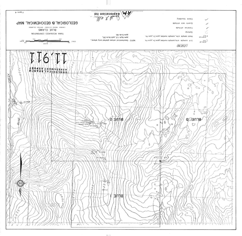
2 TABLE OF CONTENTS SUMMARY CONCLUSION RECOMMENDATION BUDGET INTRODUCTION LOCATION, ACCESS, PHYSIOGRAPHY CLAIM DATA GEOLOGY Regional Geology Property Geology GEOCHEMISTRY REFERENCES CERTIFICATE ILLUSTRATIONS Location Map Access Map Claim Map After page 4 After page 5 After page 5 APPENDIX Appendix I Analytical Results Appendix I1 Affidavit of Expenses
3 SUMMARY Tiara Resources Corporation holds the Blue claims in the Cariboo Mining ~ivision of Central British Columbia. They are situated 130 kilometres northwest of Williams Lake, near the headwaters of Blue Lead Creek. Access is by helicopter. The property was staked in 1982 to cover an antimony anomaly resulting from a regional stream sediment survey carried out by the government. Also reported in the claim area is an occurrence of galena in quartz-veined limestone. Two days were spent prospecting, mapping and sampling in March Snow conditions were hazardous, providing poor access to outcrops. The property is underlain by sericitic and graphitic phyllite, quartzite and muscovite schist. Extensive quartz veining is evident by the abundance of quartz in float. The quartzite locally contains abundant pyrite. CONCLUSION Snow conditions at the time of the examination prevented any evaluation of the Blue claims. The antimony anomalies reported in the 1980 government geochemical release were not confirmed. However, the lack of -80 material in the sediment samples collected may have affected results.
4 A sample of pyritic and quartz veined quartzite was found to carry highly anomalous gold values (900 ppb). The abundant quartz vein material observed in float indicate that ma'pping and geochemical sampling should be continued when snow conditions permit. RECOMMENDATION A three phase exploration program is recommended to examine the known showings and to evaluate the potential for precious metal and tungsten deposits. Phase I is designed to carry out a preliminary prospecting, sampling and geological mapping. Phase 11, contingent on results of Phase I, consists of follow-up geological, geochemical and geophysical surveys, and Phase 111, if results of Phases I and I1 warrant, consists of diamond drilling. The estimated costs of each are: $17,000., $27,000., and $50,000. respectively.
5 BUDGET Phase I Geological mapping, prospecting and sampling. Salaries Geologist Assistant 1 1 $6,000. $3,000. Room and board 60 man $35. Geochemical analysis and assay 1, Helicopter access and support 6 $450/hr 2, Materials and supplies Maps, report and draughting $16, %I0 1, Phase I1 Follow-up geological, geochemical and. geophysical surveys. Salaries Geologist 1 $6,000. Sampling and geophysical crew 1 $6,000. Room and board 60 man $35. Geochemical analysis 2, Helicopter access and support 10 $450/hr 4, Equipment rental Report $24, %I0 2, Phase I11 Provision for diamond drilling
6 INTRODUCTION The Blue claims were staked in 1982 to cover a 32 parts per million antkmony geochemical anomaly that was obtained from a regeional geochemical reconnaissance program carried out in 1980 by the Provincial and Federal governments (Open File 776, RGS-5) for the Quesnel Lakes area. A drainage 8 kilometres southwest of the claims yielded a 13 parts per million antimony anomaly. The claim area was reported to have been previously explored in 1975 and known as the Blue Lead property. Galena was reported to occur in quartz veins in limestone (B.C. Ministry of Mines Assessment Report 5537 and 1975 Annual Report p. E 125). The property was staked originally because of this reported occurrence and because of the potential association of gold with antimony (antimony is a common associate of gold and hence an important indicator element). Prospecting, mapping and sampling were carried out by D. Fleming and R. Kidlark on March 17 and 18, Deep snow and avalanche conditions prevailed, hindering access and providing few accessible outcrops and stream sediment sample locations.
7 FIGURE - I
8 LOCATION, ACCESS, PHYSIOGRAPHY The claims are situated 135 kilometres northeast of Williams Lake, B.C. (figures 1 and 2). and 82kilometres east of Likely, B.C. The claims cover an east flowing tri- butary of Blue Lead Creek, which in turn flows'into the east end of Quesnel Lake. Topography in the area ranges from moderately steep on the valley slopes to gentle on several flat benches. Elevations range from 1300 to 2300 metres. Access is by helicopter, based in Williams Lake or Quesnel. CLAIM DATA The property consists of 42 claim units (figure 3) as follows : Claim Name No. of Units Record No. Expiry Date Blue March 22, 1984 Blue March 22, 1984 Blue March 22, 1984 The claims are registered in the name of Douglas MacQuarrie but have been transferred to Tiara Resources Corporation. GEOLOGY Regional Geology 9 According to Campbell (1973) the area is underlain by northeast trending sedimentary rocks of the Hadryninan

9 TIARA RESOURCES LTD. ACCESS BLUE CLAIMS MAP Cariboo Mining Division - British Columbia N.T.S. 93A 1 exploration Itd. Figure 2 -.

10 TIARA RESOIJHCES CORPOHATION CLAIfll MAP N.T.S. 93 A/9W BLUE CLAIMS - British Columbia
11 (Windermere) Kaza Group and Isaac formation. Rock types include greywache, phyllite, schist and limestone. Lower Paleozoic shale and carbonate miogeosynclinal rocks outcrop north of the north arm of Quesnel Lake. Two prominent northeast trending faults cut through the property. Jurassic and Cretaceous intrusive rocks outcrop 12 kilometres to the southeast. Property Geology The Blue 1 and 2 claims, as indicated by stream bed float, are underlain dominantly by sericitic and graphitic phyllite with minor quartzite. Quartzite in outcrop was highly pyritic and quartz veins cutting the quartzite, carried minor disseminated pyrite. Streams sampled farther southwest along Blue Lead Creek, carried dominantly quartz-muscovite schist in float, with minor quartzite and phyllite. Carbonate stratigraphy was spotted from the air, southeast of Blue Lead Creek. Abundant quartz veining is evident on the claim group by angular quartz float in the stream beds. GEOCHEMISTRY Stream sediment samples were collected and where the snow cover permitted access to the creek beds. As a result, insufficient -80 mesh silt material was obtained for standard geochemical analysis.
12 The samples were therefore screened to -40 mesh and this fraction analyzed. Samples were analyzed for Mo, Cu, Ni, Co, Mn, Fe, Ag, Zn, Pb, Sb, Au and W. Sample sites are plotted on figure for and presented in Appendix I. Above background values were obtained for nickel ( >40 ppm) and tungsten ( >I0 ppm). A single grab sample from an outcrop of quartz-veined and pyritic quartzite (83 BFT 20) returned a significant gold geochemical anomaly (900 ppb Au).
13 REFERENCES Allen, D.G. (1982). Geological Report on the Blue Claims. Private Report for Tiara Resources Corporation. Boyle, R.W. (1974). Elemental Associations in Mineral Deposits and Indicator Elements of Interest in Geochemical Prospecting. Geol. Sur. Canada, Paper B.C. Ministry of Mines (1975). Blue Lead, in Annual Report for 1975 P El25 and Assessment Report Campbel, R.B. (1978). Quesnel Lake Map Area, Geol. Surv. Canada Open File 574. Geological Survey of Canada (1981). Survey, Open File 776. Regional Geochemical Maucher, A. (1976). The Strata-Bound Cinnabar-Stibnite- Scheelite Deposits in Handbook of Strata-Bound and Stratiform Ore ~epoxts Vol. 7, p
14 CERTIFICATE I, Donald G. Allen certify that: 1. I am a Consulting Geological Engineer, resident at 4570 Hoskins Road, North Vancouver, B.C. 2. I am a graduate of the University of British Columbia with degrees in Geological Engineering. (B.A.Sc., 1964; M.A.Sc., 1966) 3. I have been practising my profession since I am a member in good standing of the Association of Professional Engineers of British Columbia. 5. This report is based on fieldwork carried out by D. Fleming and R. Kidlark both of whom are in my opinion, competent geologists. 6. I hold no interest, nor do I expect to receive any, in the Blue claims or in Tiara Resources Corporation. 7. I consent to the use of this report in a Statement of Material Facts or in a Prospectus in connection with the raising of funds for the project covered by this report. April 10, 1983 North Vancouver, B.C. Donald G. Allen, P. Ecg. (B.C.)
15 CERTIFICATE I, D. B. Fleming, certify that: 1. I am a graduate of the University of British Columbia with a degree in Geology. (B. Sc., 1979). 2. I have been practising my profession since This report is based on field work carried out personally on March 17 and 18, I hold no interest, nor do I expect to receive any, in the Blue Claims or in Tiara Resources Ltd. North Vancouver, B.C. April 20, 1983 D. B. Fleming, (B. Sc., 1979)
16 APPENDIX I ANALYTICAL RESULTS
kk- / CERTIFICATE OF ANALYSIS,,,,,,,., 3099 A *cr TO: A & M EXPLSWA'BIOPI LTD. DATE ANALYSED Apri 1 I 4, I 983.")
17 0 5 b J,b,,to,y Jld KEY, TELEPHONE: B c* - GEOCHEMICAL ANALYSTS & ASSAYERS CERTlmcnrE NO. 83~)kk- / CERTIFICATE OF ANALYSIS,,,,,,,., 3099 A *cr TO: A & M EXPLSWA'BIOPI LTD. DATE ANALYSED Apri 1 I 4, I HOSKINS ROAD
18 Yco~~ba~L,, TO: GEOCHEMICAL ANALYSTS & ASSAYERS dhbo,t,,, J'td :::EY* TELEPHONE: 8.c* CERTIFICATE NO. 83&6-4 CERTIFICATE OF ANALYSIS,N,o,,, No A & hi E3"iPLOWATION l."rd HOSKINS ROAD DATE ANALYSED Apri 1 I 5, I 983. I
19 APPENDIX I1 AFFIDAVIT OF EXPENSES
20 "cr AFFIDAVIT OF EXPENSES This will certify that geochemical sampling and prospecting r,dere carried out on March 17 and 18, 1983 on the BLUE Claims, Quesnel Mining Division, Blue Lead Creek area, Sritish Columbia, to the value of the following: Mobilization and Fieldwork Salaries D. Fleming 3 $150 R. Kidlark 3 $150 Room and 'zoard Vehicle expenses and rental Field supqliss, radio rental Helicopter support 1, Geochemical analysis Report Preparation Salary D. Fleming Draughting, zyping, compilation 16 $ OO Maps, photocopying Total $4, Donald c<. Allen, P. Eng. (B.C.)
21
"E r * Xk LJ* a4w. rc&
 g3-*39s --"I144 I GEOLOGY- GEOPHYSICS 4570 HOSKINS ROAD, NORTH VANCOUVER, 6. C. TELEPHONE (804) 985.7921 V7K 2R1 GEOCHEMICAL AND GEOPHYSICAL REPORT on the JERO 1 to 4 CLAIMS (Ross land Property) Trail
exploration I td. MINING ENGINEERING
 &A GEOLOGY GEOPHYSICS exploration I td. MINING ENGINEERING Suite 614-850 WEST HASTINGS STREET. VANCOUVER, B.C. TELEPHONE (604) 681-0191 V6C 1El GEOCHEMICAL AND GEOPHYSICAL REPORT on the SUMMIT PROPERTY
RECONNAISSANCE GEOCHEMICAL SURVEY
 RECONNAISSANCE GEOCHEMICAL SURVEY LEGAL, RITA, LOUISE FR. (CHAPLEAU GROUP) REVERTED CROWN GRANTS CHAPLEAU CREEK AREAJ, SLOC& MINING DIVISION 82 F/11W Lat: 49'44" Long: 117"22'W MINERAL RESOURCES BRANCH
for the Greenwood Mining Division, B.C. NTS 82E/7W Latitude 49' 27' W, Longitude 118' 5 Prepared by a= D. Dylan Watt, B.Sc.
 t. b LOGnO: 37~ -08 m. ACTIO#: for the AMP AMP 2 AMP 3 t AMP 4 CLAIMS Greenwood Mining Division, B.C. NTS 82E/7W Latitude 49' 27' W, Longitude 8' 5 %E c,w zc *& a w Prepared by a= -4c. D. Dylan Watt, B.Sc.
PHYSICAL WORK REPORT. the BAY CLAIMS. Omineca Mining Division Smithers, British Columbia N.T.S. 93E 13E/W
 PHYSICAL WORK REPORT the BAY CLAIMS Omineca Mining Division Smithers, British Columbia a N.T.S. 93E 13E/W LATITUDE: 53 57 00 N I LONGITUDE: 127 45 OO W for Home Ventures Ltd. 1201-675 West Hastings Street
ASSESSMENT REPORT ON THE PEAVINE PROJECT. DGW & Associates # Alberni Street, Vancouver, British Columbia, V6E 4V2
 ASSESSMENT REPORT ON THE PEAVINE PROJECT KAMLOOPS MINING DIVISION BRITISH COLUMBIA NTS 082M 12 Latitude 51 36' 19.0"North -- Longitude --119 47' 27.0"West UTM Zone 11, NAD 83 5720827N 306744E Prepared
Prospecting Report 'S Office i DB Property, B.C. -J Negro Creek Nelson Mining District NTS 82F.050. Operator: Kootenay Gold Inc.
 . '.' I"' i9 12 Prospecting Report 'S Office i DB Property, B.C. -J Negro Creek Nelson Mining District NTS 82F.050 Operator: Kootenay Gold Inc. Owner: Darlene Lavoie Work Performed Summer of 2007 Report
PRECIOUS METALS. owner. JMT Services Corp. GEOCHPlICAL SAMPLING CHELASLIE WCE, NORTH CENTRAL, B.C. OMINECA MINING DIVISION NTS 93F/5E & 6W
 PRECIOUS METALS REPORT ON 1980 RECONNAISSANCE GEOCHPlICAL SAMPLING CHELASLIE WCE, NORTH CENTRAL, B.C. OMINECA MINING DIVISION NTS 93F/5E & 6W LATITUDE 53O28 N LONGITUDE 125O31 W DATES Qp WORK: JULY 10
PROSPECTORS ASSISTANCE PROGRAM MINISTRY OF ENERGY AND MINES
 BRITISH COLUMBIA PROSPECTORS ASSISTANCE PROGRAM MINISTRY OF ENERGY AND MINES GEOLOGICAL SURVEY BRANCH PROGRAM YEAR: 1999/2000 REPORT #: PAP 99-l 6 NAME: KIM ANSCHETZ PROSPECTORS TlEPORT on the 99 LOUIS
Serengeti Resources Inc GEOCHEMICAL REPORT ON THE SHADOW PROPERTY a.
 Serengeti Resources Inc. 2004 GEOCHEMICAL REPORT ON THE SHADOW PROPERTY a. Located in the Johanson Lake Area Omenica Mining Division NTS 94D/9 6 degrees and 32 minutes North Latitude 126 degrees and 2
BALFOUR MINING LTD. (N.P.L.) HAM GROUP 92-P-6, CLINTON M. D.8 B. C. Lat 51 17'N, GEOCHEMICAL REPORT. V. CUKOR, P. Eng.
 HAM GROUP 92-P-6, CLINTON M. D.8 B. C. Lat 51 17'N, GEOCHEMICAL REPORT. V. CUKOR, P. Eng.") 34q '7 BALFOUR MINING LTD. (N.P.L.) HAM GROUP 92-P-6, CLINTON M. D.8 B. C. Lat 51 17'N, Long 12lo14'W GEOCHEMICAL REPORT, V. CUKOR, P. Eng. January 31, 1972 TABLE OF CONTENTS 1. INTRODUCTION 2. PROPERTY,
34q '7 BALFOUR MINING LTD. (N.P.L.) HAM GROUP 92-P-6, CLINTON M. D.8 B. C. Lat 51 17'N, Long 12lo14'W GEOCHEMICAL REPORT, V. CUKOR, P. Eng. January 31, 1972 TABLE OF CONTENTS 1. INTRODUCTION 2. PROPERTY,
GEOLOGICAL MAPPING REPORT ON THE ASH MINERAL CLAIM OSOYOOS MINING DIVISION ASHNOLA RIVER MAP SHEET NTS M092,H019 MCBRIDE CREEK AREA, ASHNOLA RIVER,
 GEOLOGICAL MAPPING REPORT ON THE ASH MINERAL CLAIM OSOYOOS MINING DIVISION ASHNOLA RIVER MAP SHEET NTS M092,H019 LATITUDE 49 o O6, LONGITUDE 120 o 22 MCBRIDE CREEK AREA, ASHNOLA RIVER, KEREMEOS, B.C. CANADA
GEOLOGICAL MAPPING OF SKARNS ON THE SHEEP AND EWE CLAIMS, TURNAGAIN RIVER, B.C. DURING THE 1979 SUMMER SEASON
 GEOLOGICAL MAPPING OF SKARNS ON THE SHEEP AND EWE CLAIMS, TURNAGAIN RIVER, B.C. DURING THE 1979 SUMMER SEASON CLAIMS: Sheep 1 to 4 Ewe 1, 3, 4 to 8 Lamb 12 Fraction Liard Mining Division, B.C. NTS 104
490 20' 30" North Latitude ' 30" West Longitude
 _._.. I CONSULTING GEOLOGISTS 605-602 WEST HASTINGS STREET, VANCOUVER, B.C. V6B 1P2 TELEPHONE: (604) 689-5533 6 I F: ASSESSMENT REPORT ON THE PATSY 1 MINERAL CLAIM ' '?%2% I WHISTLE CREEK, HEDLEY ARE L-l-
cpw 6. E. Spencer Engineering Ltd. HANNA 9 M. C. 104 REP 0 RT DIAMOND DRILLING PROGRAMME LIARD MINING DISTRICT, K.T.S. FOR TAURUS RESOURCES LTD.
 6. E. Spencer Engineering Ltd. LlJ REP 0 RT ON DAMOND DRLLNG PROGRAMME cpw HANNA 9 M. C. LARD MNNG DSTRCT, K.T.S. 104 P@g FOR TAURUS RESOURCES LTD. BY B. E. SPENCER, P. ENG. B. E. SPENCER ENGNEERNG LTD.
SOIL GEOCHEMISTRY. OK-ll AND OK-Ill MINERAL CLAIMS MOUNT THOEN AREA OMINECA MINING DIVISION, B.C. NTS 93 MI6 E & 7 W
 SOIL GEOCHEMISTRY OK-ll AND OK-Ill MINERAL CLAIMS MOUNT THOEN AREA OMINECA MINING DIVISION, B.C. NTS 93 MI6 E & 7 W LATITUDE 55O23'N, LONGITUDE 127 01W Locke B. Goldsmith, P.Eng. Consulting Geologist December
GEOPHYSICAL REPORT CHU CHUA PROJECT Green Mountain Group. KAMLOOPS MINING DIVISION NTS 92P/8E, 82M/5W Lat: 51'24' N Long: 120'00' w
 I GEOPHYSICAL REPORT CHU CHUA PROJECT Green Mountain Group KAMLOOPS MINING DIVISION NTS 92P/8E, 82M/5W Lat: 51'24' N Long: 120'00' w I rvm #.,_..._..._._._.- $...-...! 1 VANCOUVER, B.C. 1 G E 0 I, 0.G
PROSPECTING REPORT THE WALLACE CLAIM OMENICA MINING DIVISION. 54" x6" 3.d d. for. Reako Exlorat ions Ltd. Wallace Rev. C.G.
 PROSPECTING REPORT ON THE WALLACE CLAIM OMENICA MINING DIVISION 54"44 14 1x6" 3.d d by David A. Howard P.Eng. for Reako Exlorat ions Ltd. Claim Locat ion Wallace Rev. C.G. #1560 Dome Mountain Area 9 3
compietea since tnat date, and wnicn comprisea btage I ot tne recommended
 compietea since tnat date, and wnicn comprisea btage I ot tne recommended four-stage program. GEOLOGY & MINERALIZATION The property situate6 on the southeast slope of Nickel Plate Mtn., and within the
NTS 082F03SW N W U E N
 Prospecting Report JOCELYN CLAIM NTS 082F03SW N49 09 51 W 117 14 04 11U 482906E 5445737N NELSON MINING DIVISION Martin Ross PO Box 323 Salmo BC V0G 1Z0 Jan 31, 2012 PROSPECTING REPORT JOCELYN MINERAL CLAIM
BLURTON CREEK NICKEL PROPERTY. (Minfile # 082LNW-039)
") 5489153 BLURTON CREEK NICKEL PROPERTY (Minfile # 082LNW-039) Mara Lake Area / Salmon Arm B.C NTS - 82L-11 (UTM 83/Z10, 357690E, 5614220N) Prepared by: Jim Cuttle, B.Sc., P.Geo. 86 Cloudburst Road Whistler,
5489153 BLURTON CREEK NICKEL PROPERTY (Minfile # 082LNW-039) Mara Lake Area / Salmon Arm B.C NTS - 82L-11 (UTM 83/Z10, 357690E, 5614220N) Prepared by: Jim Cuttle, B.Sc., P.Geo. 86 Cloudburst Road Whistler,
..!I AXE CLAIMS ON THE. for RICHCORE EXPLORATIONS LTO. GREENWOOD MINING DIVISION BRITISH COLUMBIA. Latitude 49O 30"; Longitude 118' 30'W NTS 82E/9W
 ON THE AXE CLAIMS for RICHCORE EXPLORATIONS LTO. GREENWOOD MINING DIVISION BRITISH COLUMBIA Latitude 49O 30"; Longitude 118' 30'W NTS 82E/9W... -... ~ i.,...._.'..!i Vancouver, B.C. September, 1980 P.
ASX Announcement. 28 January Drill results indicate large Porphyry Copper Gold System at Peenam
 ASX Announcement 28 January 2010 Drill results indicate large Porphyry Copper Gold System at Peenam Highlights: 270 metres of visible copper (gold) mineralisation in first diamond core hole at Peenam Prospect
GEOPHYSICAL REPORT ON AN INDUCED POLAR.IZATION SURVEY
 GEOPHYSICAL REPORT ON AN INDUCED POLAR.IZATION SURVEY T & V Claim Groups some 12 miles Northwest of Babine Lake, B.C. Latitude 55' 26'N Longitude 126' 35'W AUTHOR: Glen E. White, Chief Geophysicist,a,
ASSESSMENT REPORT. Geochemical and Geological Surveys. on the. Gooch#1-4. Mineral Claims. Omenica Mining District NTS 93L/7W
 f- GEOLOGICAL BRANCH ASSESSMENT REPORT ASSESSMENT REPORT Geochemical and Geological Surveys on the Gooch#1-4 Mineral Claims Omenica Mining District NTS 93L/7W LAT: 54O25'W LONG: 126O26'W Operator: SMD
ASSESSMENT REPORT GEOLOGICAL BRANCH. 50' 23 'North. GEOLOGICAL and GEOCHEMICAL SURVEYS ON THE. PUTNAM PROPERTY (Putnam Mineral Claim)
") GEOLOGICAL and GEOCHEMICAL SURVEYS ON THE PUTNAM PROPERTY (Putnam Mineral Claim) VERNON MINING DIVISION, B.C. GEOLOGICAL BRANCH ASSESSMENT REPORT NTS : Latitude: 82L17W 50' 23 'North LOCATION, ACCESS,
GEOLOGICAL and GEOCHEMICAL SURVEYS ON THE PUTNAM PROPERTY (Putnam Mineral Claim) VERNON MINING DIVISION, B.C. GEOLOGICAL BRANCH ASSESSMENT REPORT NTS : Latitude: 82L17W 50' 23 'North LOCATION, ACCESS,
GEOLOGIC SETTING OF THE WADSWORTH VEIN: AN INTRUSIVE-RELATED GOLD DISCOVERY NEAR TERRACE, B.C.
 WADSWORTH VEIN By Paul J. Wojdak, Wayne Bulmer and Daryl J. Hanson LOCATION: Lat. 54 57 33 N Long. 128 50 09 W (103I/15W) CLAIMS: ACCESS: SKEENA MINING DIVISION. The property is located in the Cedar River
49" 3-4 I4 I \ Y 59 tj
 ASSESSMENT REPORT Mary 4 FORT STEELE M.D. NTS 82G/5W 49" 3-4 4 \ Y 59 tj Owner: St. Eugene Mining Corporation Limited Operator : St. Eugene Mining Corporation Limited Author: John R. Wilson Date Submitted:
PIOTR LUTYNSKI VANCOUVER, BRITISH COLUMBIA
 AN ASSESSMENT REPORT ON GROUND MAGNETIC SURVEYING CHUCHI PROPERTY FORT ST. JAMES AREA, BRITISH COLUMBIA OMINECA M.D. 55 17 N, 124 31 W NTS 93N/ 7&8 Claims Surveyed: 597976, 597878-597880 Survey Dates:
NEW HAZELTON, OMINECA M.D.,
 PROSPECTING REPORT JUDI 1 TO 6 MINERAL CLAIMS NEW HAZELTON, OMINECA M.D., B.C. MAP 93M/4E, LAT. SS014'N, LONG. 127'33'W OWNED BY: A. L'ORSA ANTHONY L'ORSA Smithers, B.C. 21 February, 1981 TABLE OF CONTENTS
NTS 93L/9W GEOCHEMICAL AND GEOPHYSICAL REPORT MONA CLAIM OMINICA MINING DIVISION. Lati tude 54036'N; Longitude 'W
 GEOCHEMICAL AND GEOPHYSICAL REPORT ON MONA CLAIM OMINICA MINING DIVISION Lati tude 54036'N; Longitude 126018'W NTS 93L/9W April 1981 Paul Plicka Consulting Geologist LOCATION MAP INTRODUCTION TABLE OF
32?un North of Hope, B.C.,
 Geological Reconnaissance Assessment Report on portions of the Gilt Creek Group (Mike, C.G., Julie, and Gilt Mineral Claims) Situated 32?un North of Hope, B.C., New Westminster Mining Division N 'P 97H/11W
for the Greenwood Mining Division, B.C. NTS 82E/7W 29' W, Longitude 118' 53' N Prepared by D. Dylan Watt, B.Sc.
 for the FltE NO: u VOLT 1, VOLT 2, VOLT 3, & VOLT 4 CLAIMS Greenwood Mining Division, B.C. NTS 82E/7W Latitude 49' 29' W, Longitude 118' 53' N Prepared by D. Dylan Watt, B.Sc. #309-1996 Trutch Street Vancouver,
MAYO LAKE MINERALS INC
 MAYO LAKE MINERALS INC FOR IMMEDIATE RELEASE Press release 2014-05 Gold-Arsenic-Antimony Anomalies on Anderson Claim Group Follow-up Sampling on Davidson, Edmonton and Roop Claim Groups OTTAWA, ONTARIO,
Gold Mountain Group Gold Mtn. A, B, C & D Mineral Claims Record Nos. 697, 698, 699 & 700. Island Mountain Cariboo Mining Division British Columbia
 GOLD POINT RESOURCES LTD. Geophysical Survey Gold Mountain Group Gold Mtn. A, B, C & D Mineral Claims Record Nos. 697, 698, 699 & 700 Island Mountain Cariboo Mining Division British Columbia Vancouver,
ON THE LOST GOLD PROPERTY
 ON THE LOST GOLD PROPERTY NELSON MINING DIVISION BRITISH COLUMBIA Latitude: 49 18 North Longitude: 117 29.West TRIM MAPS: 82F1023,033 NTS: 8tF/5,6 By: Fred Critchlow . TABLE OF CONTENTS r PAGE lutroduction
2013 GEOLOGICAL ASSESSMENT REPORT SHERIDAN HILL PROPERTY
 2013 GEOLOGICAL ASSESSMENT REPORT ON THE SHERIDAN HILL PROPERTY NEW WESTMINSTER MINING DIVISION BRITISH COLUMBIA NTS 092G07 49 16 31 NORTH LATITUDE, 122 39 48 WEST LONGITUDE PREPARED FOR Sheridan Hill
121 deg 44' W and 53 deg 07' N
 M.R. #. R... VANCOUVER, B.C. REPORT ON THE WILLOW AND WILLOW I CLAIMS RECORD NO. 8475 AND 8476 CARIBOO MINING DIVISION NTS 93 H/4 121 deg 44' W and 53 deg 07' N 'W OWNER AND OPERATOR: RUZA RESOURCES LTD.
1 CLAIMS GEOPHYSICAL REPORT ON BOYAL SITUATE NORTHEAST OF TILLICUM MOUNTAIN GOLD AREA BURTON - NAKUSP SIQCAEJ MINING DIVISION
 GEOPHYSICAL REPORT ON BOYAL 1 CLAIMS SITUATE NORTHEAST OF TILLICUM MOUNTAIN GOLD AREA BURTON - NAKUSP SIQCAEJ MINING DIVISION CONSULTING GEOLOGIST AUGUST 1983 VANCOUVER B *C INDEX INTRODUCTION ooa,.eoaaa.aaaoaaooaoa~ao~o
GEOLOGICAL BRANCH ASSESSMENT REPORT 12. FItE NO: ACTION: THE GOLDEN MINING DIVISION, GOLDEN, Including THE NTS MAP; M82K/15W
 ACTION: FItE NO: Including 1990 GEO-CHEM SURVEY RESULTS -- THE AVD CLAIMS - THE GOLDEN MINING DIVISION, GOLDEN, B.C. NTS MAP; M82K/15W Lat. 50 deg. 55 Min. Long 116 deg. 55 min. For GEOLOGICAL BRANCH ASSESSMENT
M.R.# _..._ $._. ' VANCOUVER, R.C
 COMINCO LTD. EXPLORATION NTS: 0G/ WESTERN CANADA 0 November ASSESSEMENT REPORT GEOCHEMICAL SURVEY ON THE SADDLEHORN PROPERTY LIARD MINING DIVISION BRITISH COLUMBIA M.R.# _....._ $._. ' VANCOUVER, R.C I
REPORT. on the. Omineca Mining Division, British Columbia. Latitude N., Longitude W. NTS map sheet 93F/7E. James W. McLeod, P.Geo.
 REPORT on the CHU MOLYBDENUM PROPERTY Omineca Mining Division, British Columbia Latitude 53 21 N., Longitude 124 37 W. NTS map sheet 93F/7E James W. McLeod, P.Geo. on behalf of Mr. Chris Delorme TABLE
BGND 2-7 CLAIMS, KELOWNA, B.C.
 GEOLOGICAL EVALUATION of BGND 2-7 CLAIMS, KELOWNA, B.C. 5"'33"N; 9"33'3"W:NTS 82L/4E BEAR CREEK: 4Km NNW of Kelowna Vernon Mining Div., British Columbia by N. C., P.Geol., P. Eng. Consulting Geologist,
Geochemical Assessment Report. on the. Situated Nineteen Kilometres rth-northeast of Hope, B. C. in the. New Westminster Mining Division
 7 I Geochemical Assessment Report r on the r- I 1 Norm 1 to Norm 4 Mineral Claims c - I - 7 Situated Nineteen Kilometres rth-northeast of Hope, B. C. in the New Westminster Mining Division itude 49*32'N.,
7 MILES WEST OF PORT HARDY, B.C.
 GEOPHYSICAL REPORT VERTICAL INTENSITY MAGNETOMEER SURVEY ON LUK CLAIMS, 7 MILES WEST OF PORT HARDY, B.C. 50' 127O SE BY R. E. SHIELDS UNDER SUPERVISION OF J. R. BILLINGSLEY FOR SECOND0 MINING LTD. (N.
SOIL GEOCHEMISTRY ENTERPRISE MINE NTS 82 F/14 W ARCTEX ENGINEERING SERVICES CONSULTANT, OWNER, OPERATOR, AUTHOR JANUARY, 1.981
 SOIL GEOCHEMISTRY ENTERPRISE MINE t SLOCAN MINING DIVISION, Bn C, NTS 82 F/14 W LATITUDE 49'49') LONGITUDE 1'19' ARCTEX ENGINEERING SERVICES I L, B, GOLDSMITH, PiENG, CONSULTANT, OWNER, OPERATOR, AUTHOR
VANCOUVER, B.C. Tri 082F/ F/059
 GEOCHEMCAL REPORT t MAY L, 2006 Whbpper Mineral Claims Ailsa Lake Area Gold comm~ss16fl8f"s Offim on Mining Division VANCOUVER, B.C. Tri 082F/058 082F/059 3792 E 5486438 N Operator Kootenay Gold nc. Suite
CARIBOO - GRIZZLY ZINC PROJECT
 CARIBOO - GRIZZLY ZINC PROJECT The Grizzly Lake or Cariboo Zinc property straddles the gravel Weldwood 8400 logging road in the Grizzly Lake area about 55 kilometres northeast of Likely. Roads constructed
5 & GEOCHEMICAL REPORT. on the JULIET CLAIM. Coquihalla Area Nicola Mining Division. GRANT F. CROOKER, B.Sc., Geologist F.G.A.C.
 GEOCHEMICAL REPORT 5 & on the JULIET CLAIM Coquihalla Area Nicola Mining Division 92H-llE (49O 44 N. Lat., 121O 04 W. Long.) GRANT F. CROOKER, B.Sc., Geologist F.G.A.C.. (Owner and Operator) August 1987
SPUZZUM CREEK AREA PROSPECTING REPORT. on the NTS 92H/12E. Lat. 49" 44' Long. 121" 43' for H.J. Forsyth & J.D.
 PROSPECTING REPORT on the WREN GROUP of MINERAL CLAIMS SPUZZUM CREEK AREA NEW WESTMINSTER MINING DIVISION NTS 92H/12E Lat. 49" 44' Long. 121" 43' for H.J. Forsyth & J.D. Murphy Owners by Jay 0. Murphy,
SECOND and THIRD YEAR ASSESSMENT REPORT PROSPECTING LICENCE M, ROCK CUT PROPERTY, NTS 1N/12, NEWFOUNDLAND. ROY FRENCH (licence holder )
") SECOND and THIRD YEAR ASSESSMENT REPORT Of PROSPECTING On LICENCE 013704M, ROCK CUT PROPERTY, NTS 1N/12, NEWFOUNDLAND. By ROY FRENCH (licence holder ) Work Conducted: Sept. 17, 2008 Nov. 03, 2009 Total
SECOND and THIRD YEAR ASSESSMENT REPORT Of PROSPECTING On LICENCE 013704M, ROCK CUT PROPERTY, NTS 1N/12, NEWFOUNDLAND. By ROY FRENCH (licence holder ) Work Conducted: Sept. 17, 2008 Nov. 03, 2009 Total
1 FILMED 1. FILE NO:!..rsrru -* -. GRAND TWO CLAIM
 FILE NO:!..rsrru -* -. GRAND TWO CLAIM REPORT ON 1993 ASSESSMENT WORK GRAND TWO CLAIM REC. NO. 301849 NELSON MINING DIVISION NTS MAP SHEET 82F6/W 49 25'51" NORTH 117 18'08" WEST 1 FILMED 1 AUTHOR: R. Jordan,
CONSULTING GEOLOGICAL 8: MINING ENGINEERS STINGS STREET DA V6E 2E9 GEOPHYSICAL SURVEY SILVER QUEEN 2 ZEBALLOS AREA. B.C.
 DOLMAGE CAMPBELL & ASSOCIATES (1 975) LTD. CONSULTING GEOLOGICAL 8: MINING ENGINEERS STINGS STREET DA V6E 2E9 '' 1E O L 0 G I C A.L B'x;&a:f2:#& 'SESSMENT REPObT 12, Assessment RESOURCES LTD. 111 ReDort
GEOPHYSICAL ASSESSMENT REPORT (TOP & BOTTOM CLAIMS) MCINTYRE LAKE. VERNON MINING DIVISION, B-Cm
 MCINTYRE LAKE. VERNON MINING DIVISION, B-Cm") GEOPHYSICAL ASSESSMENT REPORT on the TOP PROPERTY (TOP & BOTTOM CLAIMS) MCINTYRE LAKE VERNON MINING DIVISION, B-Cm NTS : Latitude: 50'04' North Longitude: Owner: Consultant : Author : 118'33 ' West Brican
GEOPHYSICAL ASSESSMENT REPORT on the TOP PROPERTY (TOP & BOTTOM CLAIMS) MCINTYRE LAKE VERNON MINING DIVISION, B-Cm NTS : Latitude: 50'04' North Longitude: Owner: Consultant : Author : 118'33 ' West Brican
The Cobalt Rainbow. Airborne geophysical maps show that a north trending aeromagnetic high suggests further undiscovered mineralisation.
 The Cobalt Rainbow The property is located on Greenstone Creek, approximately 4.8 kilometres south west of the creek mouth. The property is located about 24 km due west of Campbell River, in the east-central
A GUIDE TO WRITING AN ASSESSMENT REPORT ON YOUR CLAIMS
 A GUIDE TO WRITING AN ASSESSMENT REPORT ON YOUR CLAIMS PLEASE NOTE! In the following pages, suggestions and advice are in italics, under each heading. Use as a guideline only. Items in bold should be changed
WORK COMPLETED BETWEEN
 ASSESSMENT REPORT ON THE LEGATE CREEK TOM CLAIMS OWNED BY T. CONWAY AND SITUATED I'IJ THE OMINECA MINING DIVISION LAT. 54'38', LONG. 128'10' NTS 1031/9 FINANCED BY SILVER CLOUD MINES LTD. WORK COMPLETED
twd$ yqsi+hca
 -t@~cl--t,i twd$ yqsi+hca C ASSESSMENT REPORT ON THE OR0 1-5 CLAIMS NEAR GOLDBRIDGE, B.C. Lillooet Mining Division N.T.S. 92 J / 15 W Long. 122 51.5 W. Lat. 50 47.5 N. Owned by Levon Resources Ltd. Optioned
PERCY CONTRACTING SERVICES LTD.
 GEOLOGICAL REPORT ON TEN PLACER LEASES (3139, 3140, 3141, 3142, 3143, 3144, 3145, 3146, 3147, 3148) MOREHEAD CREEK CARIB00 MINING DIVISION, B.C. 938/12W (52 38 N, 121 47 W) For PERCY CONTRACTING SERVICES
TERA 1-4; reccrd no s Clifford McNeill TENA 5-10; record no s Owner: lrnest G. Olfert
 GEOCHENIC-:-I, SURVEY REPORT ON MINXAL CLAIMS TERA 1-4; reccrd no s 9107-9110 Owner: Clifford McNeill TENA 5-10; record no s 9399-9404 Owner: lrnest G. Olfert Located in the Orineca Mining Division of
GEOCHEMICAL STREAM SAMPLING. on the PLACER LEASES NO. Jordan River/Bear Creek Area. Victoria Mining Division. Latitude 48 degrees 32 minutes N.T.S.
 GEOCHEMCAL STREAM SAMPLNG on the PLACER LEASES NO P. 8149, 8150, 8151, 8152, 8161, 8162, 8163, 8400, 10844, 10845 Jordan River/Bear Creek Area Victoria Mining Division Latitude 48 degrees 32 minutes Longitude
ASSESSMENT REPORT PROSPECTING PROGRAM ION/DIRTY JACK PROPERTY NELSON MINING DIVISION N.T.S. MAP SHEET 82F.023 UTM COORDINATES N E
 ASSESSMENT REPORT PROSPECTING PROGRAM ION/DIRTY JACK PROPERTY NELSON MINING DIVISION N.T.S. MAP SHEET 82F.023 UTM COORDINATES 5454800N - 0455235E Work Performed Summer 2007 OWNER >* ' Tom Kennedy >8 404-22
A PRELIMINARY REPORT ON THE ZYMOST2 CLAIM GROtP, TERRACE, B.C.
 NATIVE EXPLORATIONS LTD. A PRELIMINARY REPORT ON THE ZYMOST2 CLAIM GROtP, TERRACE, B.C. INTRODUCTION': The Zymoetz claim group is, at present, held under option by Native Explorations Ltd.. On the 19th
NT RESOURCES LIMITED QUARTERLY ACTIVITIES REPORT FOR THE PERIOD ENDED 30 JUNE 2010 ASX CODE: NTR
 NT RESOURCES LIMITED QUARTERLY ACTIVITIES REPORT FOR THE PERIOD ENDED 30 JUNE 2010 ASX CODE: NTR Activities Report Background NT Resources Limited ( NT Resources or the Company ) holds six granted Exploration
DSM SYNDICATE DISCOVERS POLYMETALLIC MINERALIZATION WITH TALUS GRAB SAMPLES CONTAINING UP TO PERCENT LEAD AND 18
 DSM SYNDICATE DISCOVERS POLYMETALLIC MINERALIZATION WITH TALUS GRAB SAMPLES CONTAINING UP TO 92.8 GRAMS PER TONNE GOLD, 13,643 GRAMS PER TONNE SILVER, 13.85 PERCENT LEAD AND 18.65 PERCENT COPPER FROM DIFFERENT
vox 1wo LOG NO: SEP 1 019% RD. &CTlON. JG-1, PILOT GOLD, PILOT GOLD 1 h 2. AND GOLD WING 1 TO 6 CLAIMS for HAROLD ADAMS Box 1329 Princeton, B.C.
 LOG NO: SEP 1 019% RD. &CTlON. JG-1, PLOT GOLD, PLOT GOLD 1 h 2. AND GOLD WNG 1 TO 6 CLAMS r Weyrnan Creek Area Kamloops Mining Division 82L-5W (50O22' N. Lat., 119O59' W. Long.) for HAROLD ADAMS Box 1329
SOIL GEOCHEMISTRY TUFA MINERAL CLAIM SLOCAN MINING DIVISION ZINCTON, B.C. NTS 82K 3E LATITUDE 50"02'20"N, LONGITUDE 117'11'W
 SOIL GEOCHEMISTRY TUFA MINERAL CLAIM SLOCAN MINING DIVISION ZINCTON, B.C. NTS 82K 3E LATITUDE 50"02'20"N, LONGITUDE 117'11'W LOCKE B. GOLDSMITH, P.ENG., P.GE0. CONSlULTING GEOLOGIST OCTOBER 30,2001 TABLE
6. E. Spencer Engineering Ltd. '1 iias k*-&-!
 6. E. Spencer Engineering Ltd. '1 iias k*-&-! CONSULTING GEOLOGICAL ENGINEER REPORT ON A GEOCHEMICAL SOIL SURVEY ON THE AXL 3 MINERAL CLAIM KAMLOOPS MINING DIVISION, N.T.S. 82,M/4 LATITUDE: 51O N, LONGITUDE:
UNION MINIERE EXPLORATIONS AND MINING CORPORATION LIMITED ASSESSMENT REPORT ON FITINAT MINERAL CLAIM. Alberni Mining Division Record No.
 M F )( UNION MINIERE EXPLORATIONS AND MINING CORPORATION LIMITED Suite 200, 4299 Canada Way, Burnaby, B.C. V5G 1 H4 Telephone (604) 437-9491 ASSESSMENT REPORT ON GEOCHEMICAL SOIL SURVEYS AND ROCKSAMPLING
Great Atlantic Rock Samples Return up to 5.8 oz. / ton Gold Golden Promise Property in Central Newfoundland
 Great Atlantic Rock Samples Return up to 5.8 oz. / ton Gold Golden Promise Property in Central Newfoundland FOCUSED ON EXPLORING ATLANTIC CANADA (TSXV : GR) (FRA: PH01) VANCOUVER, British Columbia August
COMINCO LTD. HORIZONTAL LOOP EM AND MAGNETIC SURVEYS ON SHA. CLAIMS 1, 2, 7 and 8 NELSON AND FORT STEELE MINING DIVISIONS, B.C.
 COMINCO LTD. EXPLORATION WESTERN DISTRICT NTS: 82-F/1 HORIZONTAL LOOP EM AND MAGNETIC SURVEYS ON SHA CLAIMS 1, 2, 7 and 8 - ASSESSMENT REPORT - NELSON AND FORT STEELE MINING DIVISIONS, B.C. Latitude Longitude
Licensed Science Officer Benchmark
 POSITION EVALUATION RATIONALE POSITION TITLE Senior Project Geologist MINISTRY AND DIVISION Energy, Mines and Petroleum Resources: Geological Division BRANCH AND SECTION Mineral Resources UNIT OR PROGRAM
MtNERAL EXPLORATION CONSULTANTS ASSESSMENT REPORT MT. MILLIGAN AREA OMINECA M.D. Latitude: 55' 07' N Longitude: 123" 56' W NTS : 93 0/4 W.
 D. L. COOKE AND ASSOCIATES LTD. MtNERAL EXPLORATION CONSULTANTS ASSESSMENT REPORT 1989 PRELIMINARY GEOCHEMICAL SURVEY KC MINERAL CLAIMS MT. MILLIGAN AREA OMINECA M.D. Latitude: 55' 07' N Longitude: 123"
The MAPLE BAY PROJECT Copper Silver - Gold
 The MAPLE BAY PROJECT Copper Silver - Gold Good grade and tonnage potential within close proximity to Tidewater The Maple Bay Copper Silver Gold Project covers highly favourable geological host rocks of
SELF POTENTIAL SURVEY OVER THE JAY GROUP, INVERMERE AREA GOLDEN MINING DIVISION, BFUTISH COLUMBIA NTS 82W8W7 82W9W LATLONG 50 30' ' FOR
 - GEOLOGICAL SURVEY BRANCH ASSESSMENT REPORTS -- -- DATE RECEI?/::D 06T 10 1996 - SELF POTENTIAL SURVEY OVER THE JAY GROUP, INVERMERE AREA GOLDEN MINING DIVISION, BFUTISH COLUMBIA NTS 82W8W7 82W9W LATLONG
ASSESShAENT REPORT Mines and Petroleum Resources. Department of. No* JIMMY MINERAL CLAIM FRANKLIN CREEK AREA, GREENWOOD M. D.
 GEOCHEMICAL REPORT ON JIMMY MINERAL CLAIM FRANKLIN CREEK AREA, GREENWOOD M. D. Lat. 49'35' OON, N.T.S. Long. 118O22' 00W 82-E-9 July 18-21, 1974 Vancouver, B.C. J.J. McDougall, P.Eng. July 21, 1974 * Department
ISKUT RIVER - TELEGRAPH CREEK: NEW EXPLORATION OPPORTUNITIES IN THE BC REGIONAL GEOCHEMICAL DATABASE
 ISKUT RIVER - TELEGRAPH CREEK: NEW EXPLORATION OPPORTUNITIES IN THE BC REGIONAL GEOCHEMICAL DATABASE By Ray Lett 1 and Wayne Jackaman 2 KEYWORDS: Regional stream sediment surveys, archival samples, gold,
PROSPECTING REPORT. Medallion Property. EVENT # TENURE # Tenure Name: GPEX CLVIII Medallion
 2006-2007 PROSPECTING REPORT Medallion Property EVENT # 4167980 TENURE # 540362 Tenure Name: GPEX CLVIII Medallion Watson Bar Region Clinton Mining Division Map 092O Central Coordinate Reference Long.
A Report on a Magnetometer Survey. Division, British Columbia. Gypsy 1-32 and Gypsy 1 Fr-9 Fr. 27 miles north of Smithers
 - A Report on a Magnetometer Survey on the Gypsy Claims, Omineca Mining Division, British Columbia Covering: Gypsy 1-32 and Gypsy 1 Fr-9 Fr Located: 27 miles north of Smithers Latitude 55O11' N Longitude
lat ' N Long ' W
 305 7 ec1;, REPORT ON THE JERY CLAIMS OF POLA RESOURCES LTD. NTS 93L/16 0 0 lat. 54 45' N Long. 126 22' W BABIXE LAKE AREA OMINECA MINING DIVISION, B.C. PAUL PLICKA CONSULTING GEOLOGIST DECEMBER 30, 1981
CAS PROJECT LEMHI COUNTY, IDAHO
 CAS PROJECT LEMHI COUNTY, IDAHO 447 N 300 W, Suite 3 Kaysville, UT 84037 (801) 544-3421 ojgatten@nae-xploration.com Prepared by: North American Mine Services, LLC. May 25, 2017 CAS Project Summary The
GEOLOGY AND LITHOGEOCHEMISTRY OF THE CHILKO-TASEKO LAKES AREA* BY G.
 B Ministry of Energy, Mines and Petroleum Resources GEOLOGICAL BRANCH MINERAL RESOURCES DIVISION NOTES TO ACCOMPANY OPEN FILE - GEOLOGY AND LITHOGEOCHEMISTRY OF THE CHILKO-TASEKO LAKES AREA* BY G. P. McLAREN
2) the identification through recent mapping of a Brucejack-style conceptual exploration target on its North Mitchell block; and
 the identification through recent mapping of a Brucejack-style conceptual exploration target on its North Mitchell block; and") NEWS RELEASE FOR IMMEDIATE RELEASE: JANUARY 19, 2018 Eskay Mining Corp. Announces 2018 Plans: Ni-Cu-Co Potential Along Red Lightning Trend toward Garibaldi s E&L Occurrence; Potential for Brucejack-Style
NEWS RELEASE FOR IMMEDIATE RELEASE: JANUARY 19, 2018 Eskay Mining Corp. Announces 2018 Plans: Ni-Cu-Co Potential Along Red Lightning Trend toward Garibaldi s E&L Occurrence; Potential for Brucejack-Style
Assessment Work Report. on the Geophysical Surveys carried out over the
 Assessment Work Report on the Geophysical Surveys carried out over the PINE GROUP of Mineral Claims 951-J-15-W Lillooet Mining Division Goldbridge, B.C. Long 122 48' Lat. 50 48' by Levon Resources Ltd.
on the SALAL CREEK MOLYBDENUM PROPERTY, SALAL CREEK, B.C. LILLOOET MINING DIVISION, BRITISH COLUMBIA
 on the J PLUG 9-12, PLUG 19-24, BAT 10-14, BAT 15 Fr., BAT 16 Fr. MINERAL CLAIMS, SALAL CREEK MOLYBDENUM PROPERTY, SALAL CREEK, B.C. LILLOOET MINING DIVISION, BRITISH COLUMBIA N.T.S. 92 J 14 LATITUDE 50
Longitude W
 APRIL GEOLOGICAL AND GEOCHEMICAL REPORT on the APRIL MINERAL CLAIMS Skeena Mining Division Lye11 Island, Queen Charlotte Islands, B.C. NTS 103B/12E Latitude 52O41 IN Longitude 13 1 4 1 W Dates of Work:
on the Diamond Drilling done on the LAKESIOE GROUP of Mineral Claims SLOCAN MINING DIVISION 82-F-14-W Long ' Lat '
 Assessment Work Report on the Diamond Drilling done on the LAKESIOE GROUP of Mineral Claims SLOCAN MINING DIVISION 82-F-14-W Long 117 22' Lat. 49 58' ADRIAN KESLER SILVERTON, B.C. operator LEVON RESOURCES
DISCOVERY OF MINERALISED PORPHYRY & MAGNETITE-COPPER-GOLD AT KAMARANGAN
 MEDUSA MINING LIMITED ABN: 60 099 377 849 Unit 7, 11 Preston Street Como WA 6152 PO Box 860 Canning Bridge WA 6153 Telephone: +618-9367 0601 Facsimile: +618-9367 0602 Email: admin@medusamining.com.au Internet:
GEOPHYSICAL REPORT ON A VLF-EM SURVEY OVER THE BOSS 1 AND 2 CLAIMS HEDLEY AREA SIMILKAMEEN MINING DIVISION BRITISH COLUMBIA
 GEOPHYSICAL REPORT i ON A VLF-EM SURVEY OVER THE BOSS 1 AND 2 CLAIMS HEDLEY AREA SIMILKAMEEN MINING DIVISION BRITISH COLUMBIA PROPERTY SURVEYED BY : 11.0 h S60W of Bedley : 49' 120O SE : N.T.S. 92~18~
'-7' REPORT ON A MAGNETOMETER SURVEY OVER PART OF THE MAX CLAIM GROUP 1-20 LAC LE JEUNE AREA KAMLOOPS MINING DIVISION KAMLOOPS, BRITISH COLUMBIA
 I,., - SUITE 102. 222 BELLEVUE WES t ANCOUVER, B. '-7' REPORT ON A I MAGNETOMETER SURVEY OVER PART OF THE MAX CLAIM GROUP 1-20 LAC LE JEUNE AREA KAMLOOPS MINING DIVISION KAMLOOPS, BRITISH COLUMBIA 50-30
National Geochemical Reconnaissance Surveys in the BC Cordillera Identify New Mineral Exploration Targets
 National Geochemical Reconnaissance Surveys in the BC Cordillera Identify New Mineral Exploration Targets By Ray Lett 1 and Peter Friske 2 KEYWORDS: Geochemistry, mineral exploration, multi-element, stream
Playfair Mining Ltd. November,
 Playfair Mining Ltd. November, 2 2016 To Discover a Significant High Grade Gold Deposit in a Favourable Jurisdiction To us: Significant means + 3 million ounces High Grade means + 10 gpt Favourable Jurisdiction
TOPOGRAPHICAL SURVEY REPORT ON THE GREENDROP PROPERTY NEAR CHILLIWACK, B.C. 92-H-3/W
 TOPOGRAPHICAL SURVEY REPORT ON THE GREENDROP PROPERTY NEW WESTMINSTER M.D. NEAR CHILLIWACK, B.C. 92-H-3/W Location: The central pap of the claims is located at coordinates 49 08'N, latitude by 121 26'W,
GEOLOGICAL BRAN ASSESS
 TITLE PAGE This report covers assessment work performed on the Mundy group, located in the Boundary Creek area, north of Greenwood, British Columbia. The work comprises of THM soil testing, trenching and
Date Submitted: June General Nature of Report: Examination of Placer Samples
 General Nature of Report: Examination of Placer Samples Claim: Gold Channel, Record Number 3775!8 1 (Gold Channel Placer Property) Mining Division: Cariboo NTS 093 G 09 W and E Latitude 520 23 N' Longitude1210
REPORT SOIL GEOCHEMICAL SURVEY. ATTYCELLEY NO. 2 GROUP (Attycelley Mineral Claims No. 7-10)
") REPORT SOIL GEOCHEMICAL SURVEY ATTYCELLEY NO. 2 GROUP (Attycelley Mineral Claims No. 7-10) Situated 7 miles east of north end of Thutade Lake, Omineca Mining Division British Columbia I Department of I
REPORT SOIL GEOCHEMICAL SURVEY ATTYCELLEY NO. 2 GROUP (Attycelley Mineral Claims No. 7-10) Situated 7 miles east of north end of Thutade Lake, Omineca Mining Division British Columbia I Department of I
Daiwan Engineering Ltd Granville strees V.ncouver, B. C. cuudr WY 1GS. M e : (604) PROSPECTING REPORT ON THE KING MINERAL CLAIMS
 PROSPECTING REPORT ON THE KING MINERAL CLAIMS") 1030-609 Granville strees V.ncouver, B. C. cuudr WY 1GS M e : (604) 688-1508 PROSPECTING REPORT ON THE KING MINERAL CLAIMS NORTH VANCOUVER ISLAND, BRITISH COLUMBIA NTS: 92Lj13E Latitude: 50" 47' Longitude:
1030-609 Granville strees V.ncouver, B. C. cuudr WY 1GS M e : (604) 688-1508 PROSPECTING REPORT ON THE KING MINERAL CLAIMS NORTH VANCOUVER ISLAND, BRITISH COLUMBIA NTS: 92Lj13E Latitude: 50" 47' Longitude:
2007 GEOLOGY REPORT. Elmo Property
 2007 GEOLOGY REPORT on the Elmo Property Lat. 49 23 North Long. 116 33 West Trim Map #: 082F.038 NTS: 82F/7 For SELKIRK MINERAL SYNDICATE 5936 Stafford Rd. Nelson, BC V1L 6P3 By: Bernhardt Augsten, P.Geo.
YELLOW ROCK RESOURCES LIMITED ABN
 YELLOW ROCK RESOURCES LIMITED ABN 90 116 221 740 16 October 2007 Companies Announcement Office ASX Limited 20 Bridge Street Sydney NSW 2000 DOUGLAS RANGE URANIUM PROJECT UPDATE Yellow Rock Resources Ltd
R.A. COMINCO LTD. EXPLORATION NTS: 92H/16. WESTERN DISTRICT January 6, 1982 ASSESSMENT REPORT 1981 SOIL GEOCHEMISTRY ON THE TROUT PROPERTY
 COMINCO LTD. EXPLORATION NTS: 92H/16 WESTERN DISTRICT January 6, 1982 ASSESSMENT REPORT 1981 SOIL GEOCHEMISTRY ON THE TROUT PROPERTY (Trout 1 and 6 Claims) SIWASH LAKE AREA, SIMILKAMEEN M.D., B.C. (Work