PROSPECTORS ASSISTANCE PROGRAM MINISTRY OF ENERGY AND MINES
|
|
|
- Elmer Harvey
- 5 years ago
- Views:
Transcription
1 BRITISH COLUMBIA PROSPECTORS ASSISTANCE PROGRAM MINISTRY OF ENERGY AND MINES GEOLOGICAL SURVEY BRANCH PROGRAM YEAR: 1999/2000 REPORT #: PAP 99-l 6 NAME: KIM ANSCHETZ
2 PROSPECTORS TlEPORT on the 99 LOUIS BOSSHART PROJECT (99 LB Grid) Greenwood Mining Division British Columbia North Latitude West Longitude NTS 082E/7 Prepared for Prospectors Assistance Program Prepared by Kim Anschetz P.O. Box 152 Rock Creek, B.C. VOH 1YO January 2000
3 PROSPECTORS REPORT 99 LB GRID TABLE OF CONTENTS APPLICATION PART A Application for Funding.4pproval Letter PART B Exploration targets include Copper and Gold skams and precious high angle shears and quartz veins. SUMMARY REPORT 1.0 Introduction 1.1 Location, Access and Physiography 1.2 Land Status 1.3 History Work Program 2.0 General Geology and Mineralization 2.1 General Geology 2.2 Exploration Targets 3.0 Discussion of Results Procedure 3.2 Rock Chip Geochemistry 3.3 Stream Sediment Geochemistry Conclusions and Recommendations
4 APPENDIX Appendix A Appendix B Appendix C Statement of Qualifications Geochemical Assay Results and Rock Chip Sample Sheet References MAPS IN POCKET Topographic Map Claim Map Sample Location Map Work Maps
5
6 99 LOUIS BOSSHART PROJECT SUMMARY This report pertains to the 1999 Prospectors Assistance Program Reference Number 99/2000 P36 to partially assess the precious and base metal potential of the 99 Louis Bosshart Project area, located in south-central British Columbia. The centre of the 99 Louis Bosshart Project is located at approximately Latitude and Longitude and can be found on the NTS Mapsheet 82E/7. The 99 Louis Bosshart is generally underlain by metasediments and metavolcanics of the Upper Paleozoic Anarchist Group; granodiorite and diorite of the Jurassic Nelson intrusions: and andesites, tuffs and conglomerates of the Eocene age. Exploration targets included copper/gold skams and precious metal mineralization associated with quartz veins and shear zones. Continued exploration efforts should include investigating the anomalous stream sediment and rock outcrop samples with follow-up geochemical and geophysical programs 1
7 I 1.0 INTRODUCTION 1.1 LOCATION, ACCESS and PHYSIOGRAPFN The 99 Louis Bosshart Project property is located in south central British Columbia. The project is centered approximately 22 km north of the village of Westbridge along the Christian Valley road between the Kettle River and Hoodoo Lake. all within the Beaverdell Range. (Figure #l). It is found on NTS Mapsheet 82Ei7 at Latitude and west Longitude. The property is accessed from the Christian Valley road along the Grouse Creek road that bisects the property from the southeast comer to the northwest comer. Elevation in the region ranges from 760 metres along Grouse Creek to 1220 metres along the upland plateaus. Topography consists of gently rolling hills in the plateau areas to extremes reliefs in the drainages. Local topography is rugged with heavily forrested, steep cliffs. 1.2 LAND STATUS No Mineral Tenure is held by the writer of this report in the area investigated under this Propsectors Assistance Program Mineral Tenure Map 82E/7 indicates the Rose #l tbru #7 two post claims have been located on the west side of the present grid and the twenty unit LARRY Claim lies to the east. Older claim posts were observed during the work program. 1.3 HISTORY The project area has been explored intermittently since Silver, gold and copper were discovered in 1896 and surface programs continued up through the 1960 s. In 1981 the Rock Creek Joint Venture completed a program of soil sampling, geologic mapping and prospecting.
8
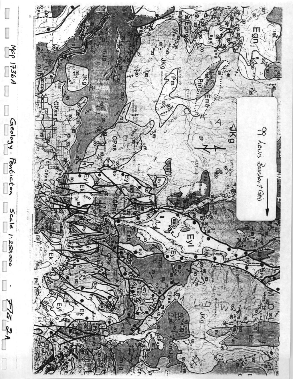
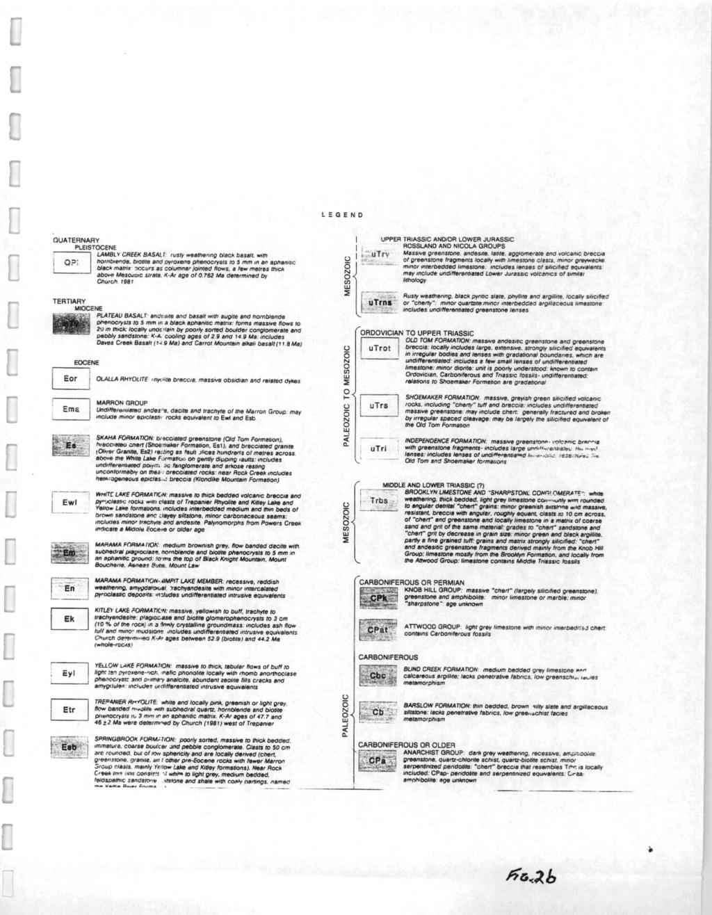
9 I r WORK PROGRAM The 1999 work program which consisted of 50 field days began May 29, 1999 and ended on October 30, A 4000 metre baseline was established from which 21 north/south grid lines each measuring 6600 metres in length were set out. Thirty (30) rock chip samples were collected along the grid and of these samples collected, 15 were submitted for assay. Fifty (50) stream sediment samples were also collected during the program and submitted for assay. Magnetometer readings were obtained from 33.5 kilometres of grid. primarily from the east and west boundaries and the southern half of the grid. The magnetometer program was hampered by extremely wet weather that caused malfunction of the magnetometer equipment. This provided erroneous results which were recorded but have not been included in this report. 2.0 GENERAL GEOLOGY and MINERALIZATION (Fig #2a, 2b & 2c) 2.1 GENERAL GEOLOGY Anarchist Group metasediments and metavolcanics are intruded by small bodies of ultramafic and mafic rocks as well as large bodies of diorite and granodiorite which are part of the Jurassic Nelson intrusions. In turn the older rocks are overlain unconformably by Tertiary age sediments and volcanic flows of the Eocene Penticton Group. Scattered occurrences of disseminated and fracture filling mineralization occurs primarily in the greenstones, including pyrite and chalcopyrite. minor galena and sphalerite, malachite and azurite staining. Massive magnetite with minor copper was also observed within the greenstone sequence, Quartz veins with thin massive sulfide lenses were also noted. 2.2 EXPLORATION TARGETS 1. Steeply dipping, high grade gold bearing quartz veins related to fault zones usually consisting white quartz with minor base metal sulfides. 2. Steep dipping epithermal veins usually silver and gold bearing related to Tertiary volcanism 3. Copper gold skams hosted by Anarchist Group? rocks near their contact with Nelson intrusives. Skam mineralization usually forms tabular bodies in both 3
10
11
12 I-- /- f- P f-
13 garnet-pyroxene-magnetite skams and quartz-pyroxene homfels within calcareous formations near their contact with the intrusive. 3.0 DISCUSSION OF RESULTS 3.1 PROCEDURE All surveys and locations related to the LB grid within the Louis Bosshart Project area were accomplished by hip chain and traverse from UTM coordinates north and east. Rock chip and stream sediment samples were collected and sent to Acme Analytical Laboratories Vancouver, B.C. for geochemical analysis. 3.2 ROCK CHIP GEOCHEMISTRY Of the fifteen rock chip samples sent for assay, rock chip sample #99LB L1400 east 4250 north was highly anomalous showing 23 ppb gold, 21,958 ppb silver and 5581 ppm copper. The sample was taken from an old trench that had exposed massive sulfide lenses related to quartz veining. 3.3 STREAM SEDIMENT GEOCHEMISTRY Several interesting anomalous gold assay results were obtained from the stream sediment sampling program. These include SS99 LB 2500E 255ON which returned a gold assay 7477 ppb along with a silver result of 983 ppb The second highest gold value came from sample number SS99 LB 2500E 595ON. This sample assayed 2355 ppb gold and 939 ppb silver. 4.0 CONCLUSlONS AND RECOMMENDATIONS Although the current program did not identify specific drill targets the reconnaissance style exploration of the 99 Louis Bosshart Project was successful in developing targets for additional detailed exploration. The target areas would include 4
14 following up the highly anomalous stream sediment samples and fkther investigation of the massive magnetite body located at approximately line 2500E. 4300N. Respectfully submitted by 5
15 APPENDIX A Statement of Qualifications
16 . STATEMENT OF QUALIFICATIONS 1 KIM ANSCHETZ of Rock Creelq British Columbia DO HEREBY CERTIFY: 1. THAT I am a Prospector with an address of P.O. Box 152 Rock Creek, British Columbia. VOH 1YO. 2. THAT I personally supervised the 1999 Propsectors Assistance Program discussed in this report DATED this 3 day of &-n ( 2000 Kid scheti, Prosped
17 APPENDIX B Geochemical Assay Results and rock Chip Sample Sheet

18
19
20
21
22 APPENDIX c References
23 PROSPECTORS REPORT 99 LB GRU) REFERENCES EMPR GEM EMPR EXF L 197%E22 EMPR ASS RPT *1722,6899, 9079 EMI R AEROMAG MAP 7686G EMPR PF (San Antonio Explorations Ltd., Prospectus, June ) GSC OFF 481;637;1969 GSC MEM 79 GSC MAP ;1736A These references are all obtained from the Up-dated 1997 MINFILE, Geological Survey Branch B.C. Ministry of Energy and Mines. British Columbia

24
25
26

27
28
The Cobalt Rainbow. Airborne geophysical maps show that a north trending aeromagnetic high suggests further undiscovered mineralisation.
 The Cobalt Rainbow The property is located on Greenstone Creek, approximately 4.8 kilometres south west of the creek mouth. The property is located about 24 km due west of Campbell River, in the east-central
for the Greenwood Mining Division, B.C. NTS 82E/7W Latitude 49' 27' W, Longitude 118' 5 Prepared by a= D. Dylan Watt, B.Sc.
 t. b LOGnO: 37~ -08 m. ACTIO#: for the AMP AMP 2 AMP 3 t AMP 4 CLAIMS Greenwood Mining Division, B.C. NTS 82E/7W Latitude 49' 27' W, Longitude 8' 5 %E c,w zc *& a w Prepared by a= -4c. D. Dylan Watt, B.Sc.
PROSPECTING REPORT. Medallion Property. EVENT # TENURE # Tenure Name: GPEX CLVIII Medallion
 2006-2007 PROSPECTING REPORT Medallion Property EVENT # 4167980 TENURE # 540362 Tenure Name: GPEX CLVIII Medallion Watson Bar Region Clinton Mining Division Map 092O Central Coordinate Reference Long.
for the Greenwood Mining Division, B.C. NTS 82E/7W 29' W, Longitude 118' 53' N Prepared by D. Dylan Watt, B.Sc.
 for the FltE NO: u VOLT 1, VOLT 2, VOLT 3, & VOLT 4 CLAIMS Greenwood Mining Division, B.C. NTS 82E/7W Latitude 49' 29' W, Longitude 118' 53' N Prepared by D. Dylan Watt, B.Sc. #309-1996 Trutch Street Vancouver,
Location/Identification
 MINFILE Detail Report BC Geological Survey Ministry of Energy, Mines and Natural Gas and Responsible for Housing Location/Identification MINFILE Number: 092L 178 National Mineral Inventory Number: 092L14
ASSESSMENT REPORT PROSPECTING PROGRAM ION/DIRTY JACK PROPERTY NELSON MINING DIVISION N.T.S. MAP SHEET 82F.023 UTM COORDINATES N E
 ASSESSMENT REPORT PROSPECTING PROGRAM ION/DIRTY JACK PROPERTY NELSON MINING DIVISION N.T.S. MAP SHEET 82F.023 UTM COORDINATES 5454800N - 0455235E Work Performed Summer 2007 OWNER >* ' Tom Kennedy >8 404-22
Prospecting Report 'S Office i DB Property, B.C. -J Negro Creek Nelson Mining District NTS 82F.050. Operator: Kootenay Gold Inc.
 . '.' I"' i9 12 Prospecting Report 'S Office i DB Property, B.C. -J Negro Creek Nelson Mining District NTS 82F.050 Operator: Kootenay Gold Inc. Owner: Darlene Lavoie Work Performed Summer of 2007 Report
UNION MINIERE EXPLORATIONS AND MINING CORPORATION LIMITED ASSESSMENT REPORT ON FITINAT MINERAL CLAIM. Alberni Mining Division Record No.
 M F )( UNION MINIERE EXPLORATIONS AND MINING CORPORATION LIMITED Suite 200, 4299 Canada Way, Burnaby, B.C. V5G 1 H4 Telephone (604) 437-9491 ASSESSMENT REPORT ON GEOCHEMICAL SOIL SURVEYS AND ROCKSAMPLING
1 FILMED 1. FILE NO:!..rsrru -* -. GRAND TWO CLAIM
 FILE NO:!..rsrru -* -. GRAND TWO CLAIM REPORT ON 1993 ASSESSMENT WORK GRAND TWO CLAIM REC. NO. 301849 NELSON MINING DIVISION NTS MAP SHEET 82F6/W 49 25'51" NORTH 117 18'08" WEST 1 FILMED 1 AUTHOR: R. Jordan,
REPORT. on the. Omineca Mining Division, British Columbia. Latitude N., Longitude W. NTS map sheet 93F/7E. James W. McLeod, P.Geo.
 REPORT on the CHU MOLYBDENUM PROPERTY Omineca Mining Division, British Columbia Latitude 53 21 N., Longitude 124 37 W. NTS map sheet 93F/7E James W. McLeod, P.Geo. on behalf of Mr. Chris Delorme TABLE
GEOPHYSICAL ASSESSMENT REPORT (TOP & BOTTOM CLAIMS) MCINTYRE LAKE. VERNON MINING DIVISION, B-Cm
 MCINTYRE LAKE. VERNON MINING DIVISION, B-Cm") GEOPHYSICAL ASSESSMENT REPORT on the TOP PROPERTY (TOP & BOTTOM CLAIMS) MCINTYRE LAKE VERNON MINING DIVISION, B-Cm NTS : Latitude: 50'04' North Longitude: Owner: Consultant : Author : 118'33 ' West Brican
GEOPHYSICAL ASSESSMENT REPORT on the TOP PROPERTY (TOP & BOTTOM CLAIMS) MCINTYRE LAKE VERNON MINING DIVISION, B-Cm NTS : Latitude: 50'04' North Longitude: Owner: Consultant : Author : 118'33 ' West Brican
ASSESSMENT REPORT ON THE PEAVINE PROJECT. DGW & Associates # Alberni Street, Vancouver, British Columbia, V6E 4V2
 ASSESSMENT REPORT ON THE PEAVINE PROJECT KAMLOOPS MINING DIVISION BRITISH COLUMBIA NTS 082M 12 Latitude 51 36' 19.0"North -- Longitude --119 47' 27.0"West UTM Zone 11, NAD 83 5720827N 306744E Prepared
ASSESSMENT REPORT GEOLOGICAL BRANCH. 50' 23 'North. GEOLOGICAL and GEOCHEMICAL SURVEYS ON THE. PUTNAM PROPERTY (Putnam Mineral Claim)
") GEOLOGICAL and GEOCHEMICAL SURVEYS ON THE PUTNAM PROPERTY (Putnam Mineral Claim) VERNON MINING DIVISION, B.C. GEOLOGICAL BRANCH ASSESSMENT REPORT NTS : Latitude: 82L17W 50' 23 'North LOCATION, ACCESS,
GEOLOGICAL and GEOCHEMICAL SURVEYS ON THE PUTNAM PROPERTY (Putnam Mineral Claim) VERNON MINING DIVISION, B.C. GEOLOGICAL BRANCH ASSESSMENT REPORT NTS : Latitude: 82L17W 50' 23 'North LOCATION, ACCESS,
ON THE LOST GOLD PROPERTY
 ON THE LOST GOLD PROPERTY NELSON MINING DIVISION BRITISH COLUMBIA Latitude: 49 18 North Longitude: 117 29.West TRIM MAPS: 82F1023,033 NTS: 8tF/5,6 By: Fred Critchlow . TABLE OF CONTENTS r PAGE lutroduction
CONTENTS. Location, Access and History...6. Tenure Status and Geology Regional Andy Property Geology Map...9
 TYPE OFWORK IN THIS REPORT EXTENT OF WORK (rn METRTC UNITS) ON WHICH CLAIMS PROJECT COSTS APPORTIONED (incl. support) GEOLOGICAL (scale, area) Ground, mapping Photo interpretation GEOPHYSICAL (line-kilometres)
32?un North of Hope, B.C.,
 Geological Reconnaissance Assessment Report on portions of the Gilt Creek Group (Mike, C.G., Julie, and Gilt Mineral Claims) Situated 32?un North of Hope, B.C., New Westminster Mining Division N 'P 97H/11W
GEOLOGICAL MAPPING REPORT ON THE ASH MINERAL CLAIM OSOYOOS MINING DIVISION ASHNOLA RIVER MAP SHEET NTS M092,H019 MCBRIDE CREEK AREA, ASHNOLA RIVER,
 GEOLOGICAL MAPPING REPORT ON THE ASH MINERAL CLAIM OSOYOOS MINING DIVISION ASHNOLA RIVER MAP SHEET NTS M092,H019 LATITUDE 49 o O6, LONGITUDE 120 o 22 MCBRIDE CREEK AREA, ASHNOLA RIVER, KEREMEOS, B.C. CANADA
SECOND and THIRD YEAR ASSESSMENT REPORT PROSPECTING LICENCE M, ROCK CUT PROPERTY, NTS 1N/12, NEWFOUNDLAND. ROY FRENCH (licence holder )
") SECOND and THIRD YEAR ASSESSMENT REPORT Of PROSPECTING On LICENCE 013704M, ROCK CUT PROPERTY, NTS 1N/12, NEWFOUNDLAND. By ROY FRENCH (licence holder ) Work Conducted: Sept. 17, 2008 Nov. 03, 2009 Total
SECOND and THIRD YEAR ASSESSMENT REPORT Of PROSPECTING On LICENCE 013704M, ROCK CUT PROPERTY, NTS 1N/12, NEWFOUNDLAND. By ROY FRENCH (licence holder ) Work Conducted: Sept. 17, 2008 Nov. 03, 2009 Total
2013 GEOLOGICAL ASSESSMENT REPORT SHERIDAN HILL PROPERTY
 2013 GEOLOGICAL ASSESSMENT REPORT ON THE SHERIDAN HILL PROPERTY NEW WESTMINSTER MINING DIVISION BRITISH COLUMBIA NTS 092G07 49 16 31 NORTH LATITUDE, 122 39 48 WEST LONGITUDE PREPARED FOR Sheridan Hill
RECONNAISSANCE GEOCHEMICAL SURVEY
 RECONNAISSANCE GEOCHEMICAL SURVEY LEGAL, RITA, LOUISE FR. (CHAPLEAU GROUP) REVERTED CROWN GRANTS CHAPLEAU CREEK AREAJ, SLOC& MINING DIVISION 82 F/11W Lat: 49'44" Long: 117"22'W MINERAL RESOURCES BRANCH
PROSPECTING REPORT. Silver Dollar Property. EVENT # TENURE # Tenure Name: GPEX Silver Dollar
 2008-2009 PROSPECTING REPORT Silver Dollar Property EVENT # 4267989 TENURE # 555462 Tenure Name: GPEX Silver Dollar Similkameen Mining Division Map 092H Central Coordinate Reference 120 06 26.9 W Longitude
sq N & %%.& GEOPHYSICAL CONSULTING rr SERVICES LTD. $%& Long. 118o3OtW N.T.S. 82 E/15 -I- AUTROR: Glen E. Whi*e, B.Sc., P. %g.
 -\ GEOCHEMICAL EXPORT.,~.,~..'.. AMORE MINERALS 1NCORPOR;ITZC,' ~. 3rd fl5 Geo 3. and 2 mineral claims, Vernon- ~ $lining Division, B. C. Lat. 49 47'T?,,/ Long. 118o3OtW N.T.S. 82 E/15 -I- AUTROR: Glen
Lat. 52' 43' N Long ' W
 &A exploration ltd MINING ENGINEERING GEOLOGY- GEOPHYSICS 4570 HOSKINS ROAD, NORTH VANCOUVER, 6. C. TELEPHONE (804) 985,7921 V7K 2R1 GEOLOGICAL AND GEOCHEMICAL REPORT on the BLUE CLAIMS Cariboo Mining
twd$ yqsi+hca
 -t@~cl--t,i twd$ yqsi+hca C ASSESSMENT REPORT ON THE OR0 1-5 CLAIMS NEAR GOLDBRIDGE, B.C. Lillooet Mining Division N.T.S. 92 J / 15 W Long. 122 51.5 W. Lat. 50 47.5 N. Owned by Levon Resources Ltd. Optioned
AiG ON THE EASTRIM mm. Record number KENNJZDY LAKE AREA - ALBERNI MINING DIVISION Map 92Fl3 W
 ON THE EASTRIM mm CLAIM Record number 3799 19 KENNJZDY LAKE AREA - ALBERNI MINING DIVISION Map 92Fl3 W 125" 23' West Lbngitude - 49" 09' North Latitude Walter GUPPY August ZO;i;! t I : AiG272002 TABLE
A New Direction. Copper-Gold Deposit at Thor TSX.V:COL. August 11, May 2013
 A New Direction Copper-Gold Deposit at Thor August 11, 2016 May 2013 TSX.V:COL FORWARD LOOKING STATEMENTS This presentation includes certain forward-looking information or forward-looking statements for
I PRELIMINARY MAGNETOMETER SURVEY
 .REPORT O N I PRELIMINARY MAGNETOMETER SURVEY and GEOLOGICAL RECONNAISSANCE L AND K GROUP OF CLAIMS Located 8 Miles East of Princeton, B. C. Similkameen Mining Division Lat. 49' 27' N. Long. 120' 16' W
PROSPECTING REPORT. Broken Hill Property. EVENT # TENURE # Tenure Name: Broken Hill. New Westminster Mining Division Map 092H
 2009-2010 PROSPECTING REPORT Broken Hill Property EVENT # 4514071 TENURE # 600988 Tenure Name: Broken Hill New Westminster Mining Division Map 092H Central Coordinate Reference 121 24 26.2 W Longitude
490 20' 30" North Latitude ' 30" West Longitude
 _._.. I CONSULTING GEOLOGISTS 605-602 WEST HASTINGS STREET, VANCOUVER, B.C. V6B 1P2 TELEPHONE: (604) 689-5533 6 I F: ASSESSMENT REPORT ON THE PATSY 1 MINERAL CLAIM ' '?%2% I WHISTLE CREEK, HEDLEY ARE L-l-
BALFOUR MINING LTD. (N.P.L.) HAM GROUP 92-P-6, CLINTON M. D.8 B. C. Lat 51 17'N, GEOCHEMICAL REPORT. V. CUKOR, P. Eng.
 HAM GROUP 92-P-6, CLINTON M. D.8 B. C. Lat 51 17'N, GEOCHEMICAL REPORT. V. CUKOR, P. Eng.") 34q '7 BALFOUR MINING LTD. (N.P.L.) HAM GROUP 92-P-6, CLINTON M. D.8 B. C. Lat 51 17'N, Long 12lo14'W GEOCHEMICAL REPORT, V. CUKOR, P. Eng. January 31, 1972 TABLE OF CONTENTS 1. INTRODUCTION 2. PROPERTY,
34q '7 BALFOUR MINING LTD. (N.P.L.) HAM GROUP 92-P-6, CLINTON M. D.8 B. C. Lat 51 17'N, Long 12lo14'W GEOCHEMICAL REPORT, V. CUKOR, P. Eng. January 31, 1972 TABLE OF CONTENTS 1. INTRODUCTION 2. PROPERTY,
4J)SESSMEN'I' REPORT BRANCH. cc" FILE No: ASSESSMENT REPORT VICTORIA MINING DIVISION. Latitude 123O SF' Longitude 48O S5'
SESSMEN'I' REPORT BRANCH. cc FILE No: ASSESSMENT REPORT VICTORIA MINING DIVISION. Latitude 123O SF' Longitude 48O S5'") ASSESSMENT REPORT - ON THE ORM 1 MINERAL CLAIM VICTORIA MINING DIVISION NTS 92B cc" Latitude 123O SF' Longitude 48O S5' 3-2. w N C FILE No: @&@LOGI.CAL BRANCH 4J)SESSMEN'I' REPORT Date : June 1, 1990 TABLE
ASSESSMENT REPORT - ON THE ORM 1 MINERAL CLAIM VICTORIA MINING DIVISION NTS 92B cc" Latitude 123O SF' Longitude 48O S5' 3-2. w N C FILE No: @&@LOGI.CAL BRANCH 4J)SESSMEN'I' REPORT Date : June 1, 1990 TABLE
PRECIOUS METALS. owner. JMT Services Corp. GEOCHPlICAL SAMPLING CHELASLIE WCE, NORTH CENTRAL, B.C. OMINECA MINING DIVISION NTS 93F/5E & 6W
 PRECIOUS METALS REPORT ON 1980 RECONNAISSANCE GEOCHPlICAL SAMPLING CHELASLIE WCE, NORTH CENTRAL, B.C. OMINECA MINING DIVISION NTS 93F/5E & 6W LATITUDE 53O28 N LONGITUDE 125O31 W DATES Qp WORK: JULY 10
FIRST YEAR ASSESSMENT REPORT PROSPECTING LICENCE 16512M MARYSTOWN AREA, BURIN PENINSULA NTS 1M/3
 FIRST YEAR ASSESSMENT REPORT OF PROSPECTING ON LICENCE 16512M MARYSTOWN AREA, BURIN PENINSULA NTS 1M/3 BY NATHANIEL NOEL MSc. FOR E. MICHELE NOEL MINERAL LICENCES: 16512 M WORK CONDUCTED: MID-SEPTEMBER
%+ '$# $) %, %*$ " $ $ ' %' !()'-!" %( %"%! " *'+ - % %$! $)! " $)!" !$ ' "! )( ! $ '%& ')- % % "!#( (( ((# $) ' ) ((* & *# ' % %"*# ( !!
 %, %*$ $ $ ' %' !()'-! %( %%! *'+ - % %$! $)! $)! !$ ' ! )( ! $ '%& ')- % % !#( (( ((# $) ' ) ((* & *# ' % %*# ( !!") 001L/14/0218 First Year Assessment Report of Prospecting, Rock and Stream Sediment Sampling On Licence 18880M, NTS 1L/14 Burin Peninsula Newfoundland and Labrador Submitted by: Keith Kelloway Work year:
001L/14/0218 First Year Assessment Report of Prospecting, Rock and Stream Sediment Sampling On Licence 18880M, NTS 1L/14 Burin Peninsula Newfoundland and Labrador Submitted by: Keith Kelloway Work year:
GEOPHYSICAL SURVEY ASSESSMENT REPORT FOR THE RHONE GROUP ROCK CREEK, B.C. AREA GREENWOOD MINING DIVISION, B.C. N.T.S.
 I ACTION: -I FILE NO:. -..J GEOPHYSICAL SURVEY ASSESSMENT REPORT FOR THE RHONE GROUP ROCK CREEK, B.C. AREA GREENWOOD MINING DIVISION, B.C. N.T.S. 82E/3E AND 82E/6E LATITUDE NORTH: 49O 15' LONGITUDE WEST:
Structural Analysis Using Hillshade Imagery. on the. LLC Property
 Structural Analysis Using Hillshade Imagery on the LLC Property Liard Mining Division NTS 104F/16W Latitude: 57 53' 47'' N Longitude: 132 03' 06'' W Owner Garry John Payie 3714 Raymond Street South, Victoria,
NTS 082F03SW N W U E N
 Prospecting Report JOCELYN CLAIM NTS 082F03SW N49 09 51 W 117 14 04 11U 482906E 5445737N NELSON MINING DIVISION Martin Ross PO Box 323 Salmo BC V0G 1Z0 Jan 31, 2012 PROSPECTING REPORT JOCELYN MINERAL CLAIM
PHYSICAL WORK REPORT. the BAY CLAIMS. Omineca Mining Division Smithers, British Columbia N.T.S. 93E 13E/W
 PHYSICAL WORK REPORT the BAY CLAIMS Omineca Mining Division Smithers, British Columbia a N.T.S. 93E 13E/W LATITUDE: 53 57 00 N I LONGITUDE: 127 45 OO W for Home Ventures Ltd. 1201-675 West Hastings Street
ASSESSMENT REPORT. Geochemical and Geological Surveys. on the. Gooch#1-4. Mineral Claims. Omenica Mining District NTS 93L/7W
 f- GEOLOGICAL BRANCH ASSESSMENT REPORT ASSESSMENT REPORT Geochemical and Geological Surveys on the Gooch#1-4 Mineral Claims Omenica Mining District NTS 93L/7W LAT: 54O25'W LONG: 126O26'W Operator: SMD
ASX Announcement. 28 January Drill results indicate large Porphyry Copper Gold System at Peenam
 ASX Announcement 28 January 2010 Drill results indicate large Porphyry Copper Gold System at Peenam Highlights: 270 metres of visible copper (gold) mineralisation in first diamond core hole at Peenam Prospect
VANCOUVER, B.C. Tri 082F/ F/059
 GEOCHEMCAL REPORT t MAY L, 2006 Whbpper Mineral Claims Ailsa Lake Area Gold comm~ss16fl8f"s Offim on Mining Division VANCOUVER, B.C. Tri 082F/058 082F/059 3792 E 5486438 N Operator Kootenay Gold nc. Suite
Reconnaissance. Of the. Denis mineral claims. Situated at Kilometer 844 of the Alaska Highway. Liard Mining Division. Northeastern British Columbia
 Reconnaissance Of the Denis mineral claims Situated at Kilometer 844 of the Alaska Highway Liard Mining Division Northeastern British Columbia N.T.S. 94M.075 Latitude 59 42 25 Longitude 127 13 12 Field
The MAPLE BAY PROJECT Copper Silver - Gold
 The MAPLE BAY PROJECT Copper Silver - Gold Good grade and tonnage potential within close proximity to Tidewater The Maple Bay Copper Silver Gold Project covers highly favourable geological host rocks of
ssment Report Prospecting Report on the Murray Property Mur 1 Mineral Claim
 dbn 3 2o02.Gold Com~iilssIOner s 1 VANCOUVER, B.C. ssment Report Prospecting Report on the Murray Property Mur 1 Mineral Claim Revelstoke Mining Division British Columbia NTS 82KI12W 50 31 North Latitude
Mineral Claims. Aspen Grove Area Nicola Mining Division, British Columbia. Latitude N., Longitude W. NTS Map Sheet 92H/lSE
 Mineral Claims Aspen Grove Area Nicola Mining Division, British Columbia Latitude 49 51 N., Longitude 120 35 W. NTS Map Sheet 92H/lSE James P. Balmer, B.SC., P.Geo. on behalf of Gary Brown November 26,2003
CSA Mine Observations Applied to the Development of Regional Exploration Models
 CSA Mine Observations Applied to the Development of Regional Exploration Models 1 Introduction Recent work completed by the geology team has resulted in an improved understanding of the CSA mine system
TABLE OF CONTENTS. Page A. INTRODUCTION 1 B. LOCATION AND ACCESS 2 C. CLAIM INFORMATION 2 D. BRIEF HISTORY 3 E. REGIONAL GEOLOGICAL FRAMEWORK 4
 TABLE OF CONTENTS Page A. INTRODUCTION 1 B. LOCATION AND ACCESS 2 C. CLAIM INFORMATION 2 D. BRIEF HISTORY 3 E. REGIONAL GEOLOGICAL FRAMEWORK 4 F. RECONNAISSANCE BEDROCK GEOLOGY 5 G. FIELD PROCEDURES 5
GOLDCLIFF TULAMEEN PORPHYRY COPPER PROJECT COPPER MOUNTAIN CAMP, BRITISH COLUMBIA THE TROJAN-CONDOR COPPER TARGET HIGHLIGHTS
 Suite 350-885 Dunsmuir Street PF 250 764 8879 TF 866 769 4802 Vancouver, BC, Canada FX604 261 8994 info@goldcliff.com V6C 1N5 GCN.TSXV www.goldcliff.com GOLDCLIFF TULAMEEN PORPHYRY COPPER PROJECT COPPER
Beekeeper Property The Geology South of Mint Lake. Cariboo Mining Division
 Beekeeper Property The Geology South of Mint Lake NTS: 93A/6 Cariboo Mining Division Claims: Beekeeper 1 #I2055 Beekeeper 2 #3892 Beekeeper 3 #7895 Beekeeper 4 #8503 Latitude: Longitude: 52 degrees 24
I 4.w.g //old. Lat. 5Oo35T Long T. for. By: James R. Glass, P. Eng. June 6, DUSTY MAC MINES LTD. (N.P.L.)
") 440 6 REPORT ON MAGNETOMETER SURVEY POD GROU'OF CLAIMS HIGHLAND VALLEY KAMLOOPS MINING DIVISION Lat. 5Oo35T Long. 120 55T 9.2 1 //old for DUSTY MAC MINES LTD. (N.P.L.) By: James R. Glass, P. Eng. June
440 6 REPORT ON MAGNETOMETER SURVEY POD GROU'OF CLAIMS HIGHLAND VALLEY KAMLOOPS MINING DIVISION Lat. 5Oo35T Long. 120 55T 9.2 1 //old for DUSTY MAC MINES LTD. (N.P.L.) By: James R. Glass, P. Eng. June
ASSESSMENT REPORT TITLE PAGE AND SUMMARY
 ASSESSMENT REPORT TITLE PAGE AND SUMMARY TITLE OF REPORT: Assessment Report on Andys Bridge Mineral Claim, Turnagain River Area TOTAL COST: $2,100 AUTHOR(S): Bruce w Downing SIGNATURE(S): Bruce W Downing
12 tons of high-grade ore was mined from the No. 1 vein with an average grade of 13 g/t gold, 3,250 g/t silver and 23.3% lead.
 DUNWELL MINE GROUP The Dunwell Mine Group (Dunwell, Dunwell East, Bear River/MM and Silvershot properties), which includes the historic, past-producing Dunwell mine, is located 8 km northeast of Stewart
Serengeti Resources Inc GEOCHEMICAL REPORT ON THE SHADOW PROPERTY a.
 Serengeti Resources Inc. 2004 GEOCHEMICAL REPORT ON THE SHADOW PROPERTY a. Located in the Johanson Lake Area Omenica Mining Division NTS 94D/9 6 degrees and 32 minutes North Latitude 126 degrees and 2
BLURTON CREEK NICKEL PROPERTY. (Minfile # 082LNW-039)
") 5489153 BLURTON CREEK NICKEL PROPERTY (Minfile # 082LNW-039) Mara Lake Area / Salmon Arm B.C NTS - 82L-11 (UTM 83/Z10, 357690E, 5614220N) Prepared by: Jim Cuttle, B.Sc., P.Geo. 86 Cloudburst Road Whistler,
5489153 BLURTON CREEK NICKEL PROPERTY (Minfile # 082LNW-039) Mara Lake Area / Salmon Arm B.C NTS - 82L-11 (UTM 83/Z10, 357690E, 5614220N) Prepared by: Jim Cuttle, B.Sc., P.Geo. 86 Cloudburst Road Whistler,
KEN ELLERBECK PLUG CLAIM GROUP EVENT #
 KEN ELLERBECK December 11, 2017 Page 47 of 48 KEN ELLERBECK December 11, 2017 Page 48 of 48 KEN ELLERBECK (Owner & Operator) TECHNICAL EXPLORATION REPORT (Event #5670220) on PROSPECTING and EXPLORING Work
REPORT ON GEOLOGICAL, GEOCHEMICAL AND GEOPHYSICAL SURVEY CONDUCTED ON THE LP 13,14,15 MINERAL CLAIMS VERNON MINING DIVISON BRITISH COLUMBIA
 REPORT ON GEOLOGICAL, GEOCHEMICAL AND GEOPHYSICAL SURVEY CONDUCTED ON THE LP 13,14,15 MINERAL CLAIMS VERNON MINING DIVISON BRITISH COLUMBIA N.T.S. 82E/15E Longitude 490 52' N. Latitude 1180 33' W. Owners
41,a* h0.iiii*bll*i2l,i DEADWOOD CREEK. for. James R. on the BOMBINI GROUP OF CLAIMS. GREENWOOD, British Columbia. Lat. 49'07' Long. 118'43 f.
 GEOLOGCAL REPORT on the BOMBN GROUP OF CLAMS DEADWOOD CREEK GREENWOOD, British Columbia Lat. 49'07' Long. 118'43 f in the GREENWOOD MNNG DVSON for FURY EXPLORATONS LTD. (N. P. L. ) Vancouver, B. C. December
Jedway Enterprises Ltd st Ave, Surrey, BC V3S 3M3
 Jedway Enterprises Ltd. 104-19286 21 st Ave, Surrey, BC V3S 3M3 Prospecting Report on the Den (Den#1 to #4) Property, Takla Landing Area, Omineca Mining Division, British Columbia NTS 93N/12 Trim 093N052,093N062
PIOTR LUTYNSKI VANCOUVER, BRITISH COLUMBIA
 AN ASSESSMENT REPORT ON GROUND MAGNETIC SURVEYING CHUCHI PROPERTY FORT ST. JAMES AREA, BRITISH COLUMBIA OMINECA M.D. 55 17 N, 124 31 W NTS 93N/ 7&8 Claims Surveyed: 597976, 597878-597880 Survey Dates:
GEOLOGICAL MAPPING OF SKARNS ON THE SHEEP AND EWE CLAIMS, TURNAGAIN RIVER, B.C. DURING THE 1979 SUMMER SEASON
 GEOLOGICAL MAPPING OF SKARNS ON THE SHEEP AND EWE CLAIMS, TURNAGAIN RIVER, B.C. DURING THE 1979 SUMMER SEASON CLAIMS: Sheep 1 to 4 Ewe 1, 3, 4 to 8 Lamb 12 Fraction Liard Mining Division, B.C. NTS 104
J.D. Mason, Prof. Engineer. Report on the Reconnaissance Magnetometer Survey. Completed for. North American Platinum Corporation Ltd.
 Report on the Reconnaissance Magnetometer Survey Completed for North American Platinum Corporation Ltd. Olivine Mountain Property, Tulameen, B.C. J.D. Mason, Prof. Engineer. November 28, 1967. Certificate
Silver Phoenix Resources Alaska Mineral Property Lichen--A Promising Copper Silver Gold Project Ready for Drill-Testing in 2017
 Silver Phoenix Resources Alaska Mineral Property Lichen--A Promising Copper Silver Gold Project Ready for Drill-Testing in 2017 Introduction, Prospect History, and Access Since 2005, Fairbanks, Alaska-based,
Queensland Mining Corporation Limited
 Queensland Mining Corporation Limited ABN 61 109 962 469 ASX Release 29 th July 2011 Drilling Commenced at Duck Creek Copper-Gold Project, Cloncurry, North-west Queensland Highlights RC drilling has commenced
Assessment Work Report. on the Geophysical Surveys carried out over the
 Assessment Work Report on the Geophysical Surveys carried out over the PINE GROUP of Mineral Claims 951-J-15-W Lillooet Mining Division Goldbridge, B.C. Long 122 48' Lat. 50 48' by Levon Resources Ltd.
Report of Gridding and Magnetic Surveys. On the. Munro Property. Munro and Beatty Townships, Ontario. Larder Lake Mining Division
 Report of Gridding and Magnetic Surveys On the Munro Property Munro and Beatty Townships, Ontario Larder Lake Mining Division Claims: 39 4244 For Big Red Diamond Corporation October 3, 2 Timmins, Ontario
GEOLOGICAL, GEOCHEMICAL AND PROSPECTING ASSESSMENT REPORT ON THE ARGENT PROPERTY. Minfile# 082M-230 (SI) TENURE WEST RAFT RIVER AREA
 TENURE WEST RAFT RIVER AREA") ii iv GEOLOGICAL, GEOCHEMICAL AND PROSPECTING ASSESSMENT REPORT ON THE ARGENT PROPERTY Minfile# 082M-230 (SI) TENURE 646545 WEST RAFT RIVER AREA NTS 082M 13E 119 O 43 34 West, 51 O 46 30North UTM Zone
ii iv GEOLOGICAL, GEOCHEMICAL AND PROSPECTING ASSESSMENT REPORT ON THE ARGENT PROPERTY Minfile# 082M-230 (SI) TENURE 646545 WEST RAFT RIVER AREA NTS 082M 13E 119 O 43 34 West, 51 O 46 30North UTM Zone
DSM SYNDICATE DISCOVERS POLYMETALLIC MINERALIZATION WITH TALUS GRAB SAMPLES CONTAINING UP TO PERCENT LEAD AND 18
 DSM SYNDICATE DISCOVERS POLYMETALLIC MINERALIZATION WITH TALUS GRAB SAMPLES CONTAINING UP TO 92.8 GRAMS PER TONNE GOLD, 13,643 GRAMS PER TONNE SILVER, 13.85 PERCENT LEAD AND 18.65 PERCENT COPPER FROM DIFFERENT
GEOPHYSICAL REPORT. Airborne Magnetometer Survey. of the SHEEP-GOAT GROUP OF MINERAL CLAIMS. near Li l looet, B.C.
 GEOPHYSICAL REPORT 977 Airborne Magnetometer Survey of the SHEEP-GOAT GROUP OF MINERAL CLAIMS near Li l looet, B.C. Lillooet Mining Division (Lat.51 'lot Long. 122 40' 7 5t0[2L05E. for DUFFEY LAKES MINES
7 MILES WEST OF PORT HARDY, B.C.
 GEOPHYSICAL REPORT VERTICAL INTENSITY MAGNETOMEER SURVEY ON LUK CLAIMS, 7 MILES WEST OF PORT HARDY, B.C. 50' 127O SE BY R. E. SHIELDS UNDER SUPERVISION OF J. R. BILLINGSLEY FOR SECOND0 MINING LTD. (N.
vox 1wo LOG NO: SEP 1 019% RD. &CTlON. JG-1, PILOT GOLD, PILOT GOLD 1 h 2. AND GOLD WING 1 TO 6 CLAIMS for HAROLD ADAMS Box 1329 Princeton, B.C.
 LOG NO: SEP 1 019% RD. &CTlON. JG-1, PLOT GOLD, PLOT GOLD 1 h 2. AND GOLD WNG 1 TO 6 CLAMS r Weyrnan Creek Area Kamloops Mining Division 82L-5W (50O22' N. Lat., 119O59' W. Long.) for HAROLD ADAMS Box 1329
A PRELIMINARY REPORT ON THE ZYMOST2 CLAIM GROtP, TERRACE, B.C.
 NATIVE EXPLORATIONS LTD. A PRELIMINARY REPORT ON THE ZYMOST2 CLAIM GROtP, TERRACE, B.C. INTRODUCTION': The Zymoetz claim group is, at present, held under option by Native Explorations Ltd.. On the 19th
MEMORANDUM. Interpretation of Magnetic and Volterra-3DIP survey MC Claims
 11966 95A Avenue, Delta, BC V4C 3W2 Canada Tel +1 (604) 582-1100 www.sjgeophysics.com MEMORANDUM Date: September 13, 2017 From: To: SUBJECT: E. Trent Pezzot Bonanza Mining Corporation Interpretation of
NEW HAZELTON, OMINECA M.D.,
 PROSPECTING REPORT JUDI 1 TO 6 MINERAL CLAIMS NEW HAZELTON, OMINECA M.D., B.C. MAP 93M/4E, LAT. SS014'N, LONG. 127'33'W OWNED BY: A. L'ORSA ANTHONY L'ORSA Smithers, B.C. 21 February, 1981 TABLE OF CONTENTS
Summary of Rover Metals Geologic Mapping Program at the Up Town Gold Project, Northwest Territories
 October 13, 2017 Summary of Rover Metals Geologic Mapping Program at the Up Town Gold Project, Northwest Territories Vancouver, British Columbia, Canada - Rover Metals Corp., Rover, is pleased to provide
NTS 93L/9W GEOCHEMICAL AND GEOPHYSICAL REPORT MONA CLAIM OMINICA MINING DIVISION. Lati tude 54036'N; Longitude 'W
 GEOCHEMICAL AND GEOPHYSICAL REPORT ON MONA CLAIM OMINICA MINING DIVISION Lati tude 54036'N; Longitude 126018'W NTS 93L/9W April 1981 Paul Plicka Consulting Geologist LOCATION MAP INTRODUCTION TABLE OF
Elverdton Copper-Gold Project Ravensthorpe, Western Australia
 FOR SALE or JV Elverdton Copper-Gold Project Ravensthorpe, Western Australia Summary: The Elverdton Copper-Gold Project is located approximately 11 kilometres south-east of Ravensthorpe town, which is
Amador Canyon Silver Mining Property Lander County, NV
 Amador Canyon Silver Mining Property Lander County, NV Over $1 million worth of exploration and evaluation work performed Favorable drill results including a return of 286 g/ton silver over 12.2 meters
N. Lat. 50' 34' W. Long. 120' 33'
 ASSESSMENT REPORT ON THE HANK I MINERAL CLAIM RECORD NO. 2831 (7) CHERRY CREEK AREA KAMLOOPS MINING DIVISION KAMLOOPS, BRITISH COLUMBIA N. Lat. 50' 34' W. Long. 120' 33' 92 - I - 10E for ANGLO WESTERN
ASSESSMENT REPORT MAGNETOMETER SURVEY GOLDEN ROD, GOLDEN ROD #2. Long.: General Delivery, Vananda, B. C.
 ASSESSMENT REPORT MAGNETOMETER SURVEY GOLDEN ROD, GOLDEN ROD #2 t=/ NTS 92~110w Lat.: Long.: 49O 44' N 124O 34' W Owner: E. Johanson General Delivery, Vananda, B. C. Operator: Rhyolite Resources I nc.
First Year Assessment Report: Report on Prospecting, Rock and Soil Sampling Carried Out From September/2012 to December/2012.
 First Year Assessment Report: Report on Prospecting, Rock and Soil Sampling Carried Out From September/2012 to December/2012 on the Clarkes Pond Property Licence 020334M Northwest Gander River,Central
TOPOGRAPHICAL SURVEY REPORT ON THE GREENDROP PROPERTY NEAR CHILLIWACK, B.C. 92-H-3/W
 TOPOGRAPHICAL SURVEY REPORT ON THE GREENDROP PROPERTY NEW WESTMINSTER M.D. NEAR CHILLIWACK, B.C. 92-H-3/W Location: The central pap of the claims is located at coordinates 49 08'N, latitude by 121 26'W,
EMPIRE DEVELOPMENT COMPANY LIMITED
 EMPIRE DEVELOPMENT COMPANY LIMITED 1017-736 Granville Street Vancouver 2, B.C. January 17, 1966 Chief Gold Commissioner, Department of Mines & Petroleum Reso,urces, Victoria, B.C. Dear Sir: The field work
BGND 2-7 CLAIMS, KELOWNA, B.C.
 GEOLOGICAL EVALUATION of BGND 2-7 CLAIMS, KELOWNA, B.C. 5"'33"N; 9"33'3"W:NTS 82L/4E BEAR CREEK: 4Km NNW of Kelowna Vernon Mining Div., British Columbia by N. C., P.Geol., P. Eng. Consulting Geologist,
CARIBOO - GRIZZLY ZINC PROJECT
 CARIBOO - GRIZZLY ZINC PROJECT The Grizzly Lake or Cariboo Zinc property straddles the gravel Weldwood 8400 logging road in the Grizzly Lake area about 55 kilometres northeast of Likely. Roads constructed
HOWE COPPER MINE PROJECT HIGH GRADE Cu-Ag with Au
 HOWE COPPER MINE PROJECT HIGH GRADE Cu-Ag with Au The Howe Copper Mine property is located approximately 55 kilometres northwest of Vancouver, BC. It is situated at 1431 metres elevation on the eastern
GEOCSZNICAL - SURVEY. ICAMLOOPS Kl.D. 2'' 6;kr. HY "'f. Alfred R. Allen,P.Eng. 1 NO.%=...,... 6"- 'I.
 t i.i GEOCSZNICAL - SURVEY i p' ICAMLOOPS Kl.D. 2'' 6;kr HY 50-64 +."'f 121-51 NE 5-10-70 : 19-10-70 Alfred R. Allen,P.Eng. I) ' 1 6"- 'I. 1 NO.%=...,..... Q.C. EXPLORATIONS LTD. 2Cl- 535 Kowe Street Vancouver
3. GEOLOGY. 3.1 Introduction. 3.2 Results and Discussion Regional Geology Surficial Geology Mine Study Area
 3. GEOLOGY 3.1 Introduction This chapter discusses the baseline study of the geology and mineralization characteristics of the mine study area. The study consolidates existing geological data and exploration
Verification Rock Geochemical Survey on the Casino Property
 Verification Rock Geochemical Survey on the Casino Property Trail Creek Mining Division British Columbia NTS 082F04 Latitude 49 04 40.3 North Longitude 117 39 1.4 West UTM Zone 11, NAD 83 5436320N 452500E
ASSESSMENT REPORT GRID LOCATION SOIL GEOCHEMICAL SURVEY CAT TRAIL CONSTRUCTION. at Mohawk Creek, B. c.
 ASSESSMENT REPORT GRID LOCATION SOIL GEOCHEMICAL SURVEY CAT TRAIL CONSTRUCTION at Mohawk Creek, B. c. _....,.. :lii I. 50"46'N, 118O36'W Claims: Mohawk 1, 8 Ff, 9 Fr, 10 Fr. Hawk 2, 3 Pool 3, 5 Fr Fiver
Technical Report. Geochemical Sampling of Raymond Creek on Vancouver Island. Victoria Mining District 092C 15. UTM Co-ordinates N E
 Technical Report Geochemical Sampling of Raymond Creek on Vancouver Island Victoria Mining District 092C 15 UTM Co-ordinates 5414044N 389836E Owner of Claims is Dean Arbic(133434) Report Written by Dean
CONSULTING GEOLOGICAL 8: MINING ENGINEERS STINGS STREET DA V6E 2E9 GEOPHYSICAL SURVEY SILVER QUEEN 2 ZEBALLOS AREA. B.C.
 DOLMAGE CAMPBELL & ASSOCIATES (1 975) LTD. CONSULTING GEOLOGICAL 8: MINING ENGINEERS STINGS STREET DA V6E 2E9 '' 1E O L 0 G I C A.L B'x;&a:f2:#& 'SESSMENT REPObT 12, Assessment RESOURCES LTD. 111 ReDort
lat ' N Long ' W
 305 7 ec1;, REPORT ON THE JERY CLAIMS OF POLA RESOURCES LTD. NTS 93L/16 0 0 lat. 54 45' N Long. 126 22' W BABIXE LAKE AREA OMINECA MINING DIVISION, B.C. PAUL PLICKA CONSULTING GEOLOGIST DECEMBER 30, 1981
ASX Announcement. New economic gold results confirm Dave East as an exciting new discovery. Highlights. 4 July 2011
 4 July 2011 ASX Announcement New economic gold results confirm Dave East as an exciting new discovery Level 2, 9 Colin Street West Perth WA 6005 ABN 11 127 171 877 p (08) 9216 1000 f (08) 9481 7939 w www.predictivediscovery.com
We are committed to providing accessible customer service. If you need accessible formats or communications supports, please contact us.
 We are committed to providing accessible customer service. If you need accessible formats or communications supports, please contact us. Nous tenons à améliorer l accessibilité des services à la clientèle.
HDN MINERAL PRO iperty
 HDN MINERAL PRO iperty ROCK SAMPLE GEOCHEMISTRY ASSESSMENT REPORT 2010 OMINECA MINING DIVISION, BRITISH COLUMBIA 93L047 LATITUDE: 54 29' 16.9" N LONGITUDE: 126 39' 39.8" W GPS: NAD 83 UTM ZONE 9 NORTHING:
GEOCHEMICAL AND PROSPECTING REPORT. RC ly 2,3,4 CLAIMS
 p- ON GEOLOGlCAL SURVEY BRANCH ASSESSMENT REPORTS - DATE RECFl'dFD AFR 0 1 19% GEOCHEMICAL AND PROSPECTING REPORT THE RC ly 2,3,4 CLAIMS IARD MINING DIVISION BRIT1 S H COLUMBIA 94E/EI W LATITUDE 57" 48'
BCGold Corp. Discovery Driven
 BCGold Corp. Discovery Driven Sickle-Sofia Property Copper-Gold Porphyry Discovery in the Toodoggone Camp! Cautionary Statement This presentation does not constitute an offer to sell or solicitation of
MINERAL MOUNTAIN RESOURCES LTD. MMV.TSX-V
 MINERAL MOUNTAIN RESOURCES LTD. 201-1416 West 8 th Avenue Vancouver, B.C. V6H 1E1 T: 604-714-0111 F: 604-714-1119 MMV.TSX-V NEWS RELEASE March 3, 2011 No. 2011-04 MINERAL MOUNTAIN DRILLS 3.17 g/t OVER
Longitude W
 APRIL GEOLOGICAL AND GEOCHEMICAL REPORT on the APRIL MINERAL CLAIMS Skeena Mining Division Lye11 Island, Queen Charlotte Islands, B.C. NTS 103B/12E Latitude 52O41 IN Longitude 13 1 4 1 W Dates of Work:
5 & GEOCHEMICAL REPORT. on the JULIET CLAIM. Coquihalla Area Nicola Mining Division. GRANT F. CROOKER, B.Sc., Geologist F.G.A.C.
 GEOCHEMICAL REPORT 5 & on the JULIET CLAIM Coquihalla Area Nicola Mining Division 92H-llE (49O 44 N. Lat., 121O 04 W. Long.) GRANT F. CROOKER, B.Sc., Geologist F.G.A.C.. (Owner and Operator) August 1987