3. GEOLOGY. 3.1 Introduction. 3.2 Results and Discussion Regional Geology Surficial Geology Mine Study Area
|
|
|
- Candice Cameron
- 5 years ago
- Views:
Transcription
1 3. GEOLOGY 3.1 Introduction This chapter discusses the baseline study of the geology and mineralization characteristics of the mine study area. The study consolidates existing geological data and exploration data collected through The mine study area is illustrated in Figure 1-4 in Chapter 1. The baseline geology study had an emphasis on the mine study area and included a review of information from exploration drilling programs, geophysics, geotechnical site investigation programs (which included drilling and test-pitting), and aerial-photograph interpretation. Geologic information for surrounding areas was obtained from desktop studies and reviews of existing published information. 3.2 Results and Discussion Regional Geology The mine study area lies within the northern circum-pacific orogenic belt with a complex structural setting created by an active continental margin. The structure of the mine study area is broadly defined by northeast-trending faults related to translational motion along the Lake Clark Fault. The Lake Clark Fault lies on a lithotectonic boundary between the Peninsular Terrane to the east and the Kahiltna Terrane to the west. The mine study area lies within the Kahiltna Terrane, just northwest of the contact with the Peninsular Terrane Surficial Geology Mine Study Area Four different episodes of glaciation have been recognized in the mine study area and have produced unconsolidated surficial deposits a few to several tens of meters thick that cover most of the lower elevations (Detterman and Reed, 1973). Bow-shaped glacial drift ridges, meltwater deposits with abundant kettle depressions, broad glaciofluvial deposits, elongate valley deposits, and meltwater channels dominate the surficial geology. Rubble formed by frost action covers many of the gently rounded hilltops and upland surfaces in the study area. Lobes of thin, water-logged sediments slide over less permeable materials on the upper part of hills. These lobes pile up on the mid-slopes of valleys. Glacial drift deposits, which were deposited by ice that moved in a south to southwesterly direction, are found at lower elevations Bedrock Geology Mine Study Area Bedrock types in the mine study area include a bedded sequence of Jurassic to Cretaceous, mainly andesitic, sedimentary rocks; contemporary mafic extrusive and subvolcanic rocks; October 31,
2 Pebble Project Environmental Baseline Studies, , Technical Summary Cretaceous intrusive rocks of diverse composition; and stratified Tertiary volcanics, sedimentary rocks, and subvolcanic dykes. A key feature of the area is a north-northeast-trending belt of stocks, sills, and dykes of diverse composition that include pyroxenite, gabbro, diorite, monzodiorite, monzonite, syenomonzonite, and granodiorite, as well as bodies of felsic to intermediate intrusion breccia. This belt has been traced for 22 kilometers in the study area. It cuts the andesitic sedimentary rocks on the eastern and southern margins of the Kaskanak Batholith and is localized along a potentially major northeast-trending structure of crustal scale that extends beyond the Pebble Deposit. Magmatic hydrothermal activity in this belt has produced many gold, copper-gold, and copper-goldmolybdenum mineral occurrences that have a close spatial and temporal relationship to more felsic intrusive phases Structural Geology Mine Study Area The general deposit location is divided into three main zones: the Pebble West Zone, the Central Zone, and the Pebble East Zone. These zones manifest distinct combinations of geological and hydrothermal characteristics. The primary structural feature of the Pebble West and Central zones is a broad, M-shaped convex upward fold. This fold is defined by the distribution of diorite and granodiorite sills in the gently to moderately dipping sedimentary rocks in the Central Zone. Fold axes plunge gently to the southeast. Folding has not yet been recognized in the Pebble East Zone. Tertiary faults and shear zones are evident in drill core and from surface mapping. The general deposit location is cut by numerous brittle faults. Seven major fault zones (ZA to ZG) have been identified in the area of the general deposit location from drill-core data. A narrow, steeply sided, depressed segment of crust, bounded by faults, trending northeast subparallel to the regional Lake Clark structural zone extends along the valley northwest of Koktuli Mountain Deposit Geology Based on the available data, the deposit is a copper-gold-molybdenum, calc-alkalic porphyry system and covers an area of approximately16 square kilometers. Each of the three main zones has distinct geological and hydrothermal characteristics. The Pebble West Zone is dominated by a multiphase, intrusive complex that contains abundant intrusion breccias. These rocks were intruded into gently deformed andesitic sedimentary rocks and were subsequently intruded by granodiorite stocks and sills whose later-stage fluids produced potassium-silicate alteration and high-grade copper-gold-molybdenum mineralization. The Central Zone and the Pebble East Zone are dominated by hornfelsed volcanosedimentary strata that were intruded by two main diorite sills. The Central Zone contains mineralization of moderate grade. The Pebble East Zone contains intense potassium-silicate alteration and highgrade copper-gold-molybdenum mineralization. 3-2 October 31, 2011
3 3.2.6 Surficial Geology Transportation-corridor Study Area A brief inspection of aerial photographs of the transportation-corridor study area was conducted. The Quaternary surficial deposits in the study area largely consist of glacial drift and glaciofluvial deposits, with fluvial deposits present near stream channels and a few localized swamp deposits. There are also areas of loose accumulations of rock and soil debris deposits, and scattered bedrock outcrops are common. 3.3 References Detterman, R.L., and B.L. Reed Surficial Geology of the Iliamna Quadrangle, Alaska. U.S. Department of the Interior, Geological Survey Bulletin # 1368-A. October 31,
4


5 Boulders and rubble caused by frost action, mine study area. Bedrock outcrop in mine study area, looking northwest to Cone Mountain.

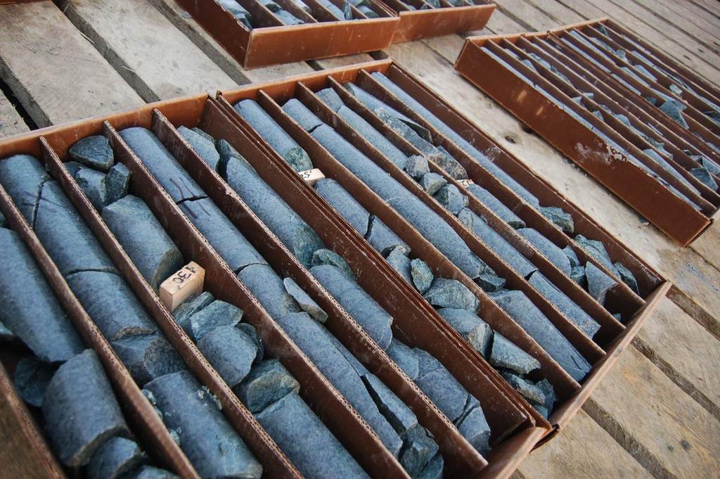
6 Typical bedrock cores from exploration/geotechnical drilling.
6. GEOTECHNICAL STUDIES, SEISMICITY AND VOLCANISM
 Geotechnical Studies, Seismicity, and Volcanism Bristol Bay Drainages 6. GEOTECHNICAL STUDIES, SEISMICITY AND VOLCANISM 6.1 Introduction This chapter describes the baseline geotechnical characteristics
Environmental Baseline Document Geology and Mineralization Agency Meetings, January 31 February 3, 2012 Anchorage, Alaska Louise Shannon, P.Eng.
 Environmental Baseline Document Geology and Mineralization Agency Meetings, January 31 February 3, 2012 Anchorage, Alaska Louise Shannon, P.Eng. Presentation Outline Introduction Exploration Alaska Regional
EXISTING GEOLOGICAL INFORMATION
 CHAPER 3 EXISTING GEOLOGICAL INFORMATION 3-1 General Geology of the Surrounding Area (1) General geology and ore deposits in Mongolia Geographically, Mongolia is a country located between Russia to the
Which landscape best represents the shape of the valleys occupied by glaciers? A) B) C) D)
 B) C) D)") 1. Glaciers often form parallel scratches and grooves in bedrock because glaciers A) deposit sediment in unsorted piles B) deposit rounded sand in V-shaped valleys C) continually melt and refreeze D) drag
1. Glaciers often form parallel scratches and grooves in bedrock because glaciers A) deposit sediment in unsorted piles B) deposit rounded sand in V-shaped valleys C) continually melt and refreeze D) drag
=%REPORT RECONNAISSANCE OF CHISHOLM LAKE PROSPECT. October 25, 1977
 =%REPORT ON FIELD RECONNAISSANCE OF CHISHOLM LAKE PROSPECT October 25, 1977 Bruce D. Vincent Imperial Oil Limited, Minerals - Coal, CALGARY, ALBERTA CHISHOLM LAKE PROSPECT Introduction The Chisholm Lake
Drill locations for the 2015 program are highlighted in the geology map below.
 2015 Exploration Program The exploration program plan at KSM for 2015 was designed to improve the understanding of block cave targets and support engineering/environmental aspects of development scenarios.
Geology of Quesnel and Stikine terranes and associated porphyry deposits. Jim Logan Paul Schiarizza
 Geology of Quesnel and Stikine terranes and associated porphyry deposits Jim Logan Paul Schiarizza Quesnel and Stikine terranes Major cordilleran terranes characterized by similar Late Triassic Early Jurassic
NATIONAL EXAMINATIONS - May ~012
 04-8S-14 Geology (May 2012) Page 1 of 10 NATIONAL EXAMINATIONS - May ~012 04-85-14 Geology 3 hours duration NOTES: A. If doubt exists as to the interpretation of any question, the candidate is urged to
Answers: Internal Processes and Structures (Isostasy)
") Answers: Internal Processes and Structures (Isostasy) 1. Analyse the adjustment of the crust to changes in loads associated with volcanism, mountain building, erosion, and glaciation by using the concept
Answers: Internal Processes and Structures (Isostasy) 1. Analyse the adjustment of the crust to changes in loads associated with volcanism, mountain building, erosion, and glaciation by using the concept
GEOLOGY OF THE NICOLA GROUP BETWEEN MISSEZULA LAKE AND ALLISON LAKE
 GEOLOGY OF THE NICOLA GROUP BETWEEN MISSEZULA LAKE AND ALLISON LAKE (92H/15E. 10E1 By V. A. Preto INTRODUCTION Mapping was continued southward from the area covered in 1973 and an additional 55 square
Topics Laramide Orogeny: Late Cretaceous to Early Eocene Reading: GSA DNAG volume 3, Ch. 6
 Topics Laramide Orogeny: Late Cretaceous to Early Eocene Reading: GSA DNAG volume 3, Ch. 6 Late Cretaceous to early Eocene New patterns developed 5 main regions Tectonic interpretations Post-Laramide events
PRINCETON BASIN (92H/7E, 8W. 9W, 10E)
") PRINCETON BASIN (92H/7E, 8W. 9W, 10E) By R. D. McMechan INTRODUCTION Remapping of the Princeton basin, south-central British Columbia, was undertaken during the summer of 1975 in order to: (1) produce
PRINCETON BASIN (92H/7E, 8W. 9W, 10E) By R. D. McMechan INTRODUCTION Remapping of the Princeton basin, south-central British Columbia, was undertaken during the summer of 1975 in order to: (1) produce
Page 1. Name:
 Name: 1) Which property would best distinguish sediment deposited by a river from sediment deposited by a glacier? thickness of sediment layers age of fossils found in the sediment mineral composition
 Page 1 of 9 Name: Base your answer to the question on the diagram below. The arrows show the direction in which sediment is being transported along the shoreline. A barrier beach has formed, creating a
The Palmer Hill Glacial-Marine Delta, Whitefield, Maine
 Maine Geologic Facts and Localities December, 2010, Maine 44 o 10 12.16 N, 69 o 37 18.93 W Text by Woodrow Thompson, Department of Agriculture, Conservation & Forestry 1 Introduction The most recent continental
GEOPHYSICS GRAVITY DATA COVERAGE
 GEOPHYSICS DATA COVERAGE The Mudgee-Gulgong district lies within the Dubbo 1:250,000 sheet area. This area is now covered by high res_olution gravity, magnetic and radiometric data. The aeromagnetic and
FIRST YEAR ASSESSMENT REPORT PROSPECTING LICENCE 16512M MARYSTOWN AREA, BURIN PENINSULA NTS 1M/3
 FIRST YEAR ASSESSMENT REPORT OF PROSPECTING ON LICENCE 16512M MARYSTOWN AREA, BURIN PENINSULA NTS 1M/3 BY NATHANIEL NOEL MSc. FOR E. MICHELE NOEL MINERAL LICENCES: 16512 M WORK CONDUCTED: MID-SEPTEMBER
to represent sediments deposited through a series of marine transgressive
 i Hydrogeol ogy of Sal tsprinq s1 and Two main assemblages of rocks directly underly Saltspring sland. The Napajmo Group of Upper Cretaceous aqe comprising sedimentary rocks lies in th, brthern half and
GEOLOGIC MAPS PART II
 EARTH AND ENVIRONMENT THROUGH TIME LABORATORY - EES 1005 LABORATORY FIVE GEOLOGIC MAPS PART II Introduction Geologic maps of orogenic belts are much more complex than maps of the stable interior. Just
CHAPTER 28. PHYSIOGRAPHY Cook Inlet Drainages
 PEBBLE PROJECT ENVIRONMENTAL BASELINE DOCUMENT 2004 through 2008 CHAPTER 28. PHYSIOGRAPHY Cook Inlet Drainages PREPARED BY: Knight Piésold Ltd. PHYSIOGRAPHY COOK INLET DRAINAGES TABLE OF CONTENTS TABLE
Figure 1 The map shows the top view of a meandering stream as it enters a lake. At which points along the stream are erosion and deposition dominant?
 1. In which type of climate does chemical weathering usually occur most rapidly? 1. hot and dry 3. cold and dry 2. hot and wet 4. cold and wet 2. Figure 1 The map shows the top view of a meandering stream
AN ASSESSMENT OF SPECTREM AND ZTEM DATA OVER THE PEBBLE COPPER- GOLD PORPHYRY COPPER DEPOSIT, ALASKA
 AN ASSESSMENT OF SPECTREM AND ZTEM DATA OVER THE PEBBLE COPPER- GOLD PORPHYRY COPPER DEPOSIT, ALASKA Ken Witherly Condor Consulting,Inc. Lakewood, CO, USA ken@condorconsult.com SUMMARY In the present study
Geologic Structures. Changes in the shape and/or orientation of rocks in response to applied stress
 Geologic Structures Changes in the shape and/or orientation of rocks in response to applied stress Figure 15.19 Can be as big as a breadbox Or much bigger than a breadbox Three basic types Fractures >>>
LOS AZULES April 2018
 April 2018 lies along the southern extensions of the highly productive Paleocene Mineral Belt in northern Chile that contains numerous important copper, gold and silver mines and projects, and to the south
The Geology of Sebago Lake State Park
 Maine Geologic Facts and Localities September, 2002 43 55 17.46 N, 70 34 13.07 W Text by Robert Johnston, Department of Agriculture, Conservation & Forestry 1 Map by Robert Johnston Introduction Sebago
Magmatism in Western Cascades Arc. Early Tertiary Magmatism Part II. Washington Magmatism. Western Oregon. Southern Oregon
 Early Tertiary Magmatism Part II Reference: DNAG v. 3, Ch. 7, pp 294-314 Magmatism in Western Cascades Arc Active from 38 to 17 Ma New volcanic activity west of Clarno Fm and south into Oregon Western
Midterm Review. Nata/Lee
 Name: 1. Which statement best supports the theory that all the continents were once a single landmass? (1) Rocks of the ocean ridges are older than those of the adjacent sea floor. (2) Rock and fossil
Summary of Rover Metals Geologic Mapping Program at the Up Town Gold Project, Northwest Territories
 October 13, 2017 Summary of Rover Metals Geologic Mapping Program at the Up Town Gold Project, Northwest Territories Vancouver, British Columbia, Canada - Rover Metals Corp., Rover, is pleased to provide
GLY 155 Introduction to Physical Geology, W. Altermann. Press & Siever, compressive forces. Compressive forces cause folding and faulting.
 Press & Siever, 1995 compressive forces Compressive forces cause folding and faulting. faults 1 Uplift is followed by erosion, which creates new horizontal surface. lava flows Volcanic eruptions cover
Amador Canyon Silver Mining Property Lander County, NV
 Amador Canyon Silver Mining Property Lander County, NV Over $1 million worth of exploration and evaluation work performed Favorable drill results including a return of 286 g/ton silver over 12.2 meters
Introduction to Prospecting. Session Two Geology
 Introduction to Prospecting Session Two Geology The Earth Earth is 4.6 billion years old (Ba). Bacteria & algae +3.5 Ba. Microscopic animals ~2 Ba. Animals ~600 million years (Ma) old. Mankind about 100,000
Beekeeper Property The Geology South of Mint Lake. Cariboo Mining Division
 Beekeeper Property The Geology South of Mint Lake NTS: 93A/6 Cariboo Mining Division Claims: Beekeeper 1 #I2055 Beekeeper 2 #3892 Beekeeper 3 #7895 Beekeeper 4 #8503 Latitude: Longitude: 52 degrees 24
ARGENTINE FRONTIER RESOURCES INC (AFRI) SALTA EXPLORACIONES SA (SESA)
 SALTA EXPLORACIONES SA (SESA)") ARGENTINE FRONTIER RESOURCES INC (AFRI) SALTA EXPLORACIONES SA (SESA) LA SARITA IOCG-Porphyry Copper-Gold August 2006 La Sarita Cateo 2 La Sarita - bleached center is Taca Taca Arriba. The hematite zone
ARGENTINE FRONTIER RESOURCES INC (AFRI) SALTA EXPLORACIONES SA (SESA) LA SARITA IOCG-Porphyry Copper-Gold August 2006 La Sarita Cateo 2 La Sarita - bleached center is Taca Taca Arriba. The hematite zone
MEMO. TO: Dennis Lapoint CC: FROM: Eriaan Wirosono DATE: April, 20 th 2014 SUBJECT: Exploration activity report March-April 2014_EW
 TO: Dennis Lapoint CC: FROM: Eriaan Wirosono DATE: April, 20 th 2014 SUBJECT: Exploration activity report March-April 2014_EW MEMO 1. Highlights and Productivity Overview pan sampling on target Areas 1
lat ' N Long ' W
 305 7 ec1;, REPORT ON THE JERY CLAIMS OF POLA RESOURCES LTD. NTS 93L/16 0 0 lat. 54 45' N Long. 126 22' W BABIXE LAKE AREA OMINECA MINING DIVISION, B.C. PAUL PLICKA CONSULTING GEOLOGIST DECEMBER 30, 1981
GEOLOGICAL MAPPING OF SKARNS ON THE SHEEP AND EWE CLAIMS, TURNAGAIN RIVER, B.C. DURING THE 1979 SUMMER SEASON
 GEOLOGICAL MAPPING OF SKARNS ON THE SHEEP AND EWE CLAIMS, TURNAGAIN RIVER, B.C. DURING THE 1979 SUMMER SEASON CLAIMS: Sheep 1 to 4 Ewe 1, 3, 4 to 8 Lamb 12 Fraction Liard Mining Division, B.C. NTS 104
Tucson Geologic History: Cenozoic ( Ma (million years ago)) Dr. Jan C. Rasmussen
) Dr. Jan C. Rasmussen") Tucson Geologic History: Cenozoic (65.5 0 Ma (million years ago)) Dr. Jan C. Rasmussen www.janrasmussen.com Temp. & Geologic Time Scale 4.6 Ga Tertiary 65-0 Ma Orogenies (mountain building) Cenozoic Formations
Tucson Geologic History: Cenozoic (65.5 0 Ma (million years ago)) Dr. Jan C. Rasmussen www.janrasmussen.com Temp. & Geologic Time Scale 4.6 Ga Tertiary 65-0 Ma Orogenies (mountain building) Cenozoic Formations
Igneous Rocks. Igneous Rocks. Genetic Classification of
 Igneous Rocks Fig. 5.1 Genetic Classification of Igneous Rocks Intrusive: crystallized from slowly cooling magma intruded within the Earth s crust; e.g. granite, gabbro 1 Fig. 5.2 Genetic Classification
TECHNICAL REPORT: REGIONAL GEOLOGY AND TECTONICS Resume. Huachon Project, Cerro de Pasco departments, Peru. By: AFC Logistic SAC
 TECHNICAL REPORT: REGIONAL GEOLOGY AND TECTONICS Resume Huachon Project, Cerro de Pasco departments, Peru By: AFC Logistic SAC December 2016 1. INTRODUCTION GPM Metals Peru, in its portfolio of generating
Continental Landscapes
 Continental Landscapes Landscape influenced by tectonics, climate & differential weathering Most landforms developed within the last 2 million years System moves toward an equilibrium Continental Landscapes
The boulder was most likely moved to this location by A) glacial ice B) prevailing wind C) streamfiow D) volcanic action
 glacial ice B) prevailing wind C) streamfiow D) volcanic action") 1. Which rock material was most likely transported to its present location by a glacier? A) rounded sand grains found in a river delta B) rounded grains found in a sand dune C) residual soil found on a
1. Which rock material was most likely transported to its present location by a glacier? A) rounded sand grains found in a river delta B) rounded grains found in a sand dune C) residual soil found on a
Introducti on. Land Survey. Geomagnetic Survey. Geomagnetic Results and Interpretati ons - Conclusions and Recommendations C
 m M 42A86SW8281 63.42 PRICE 010 C O H T E H l 42A86SW828I 63.42 PRICE 010C Introducti on Land Survey Geomagnetic Survey Geomagnetic Results and Interpretati ons - Conclusions and Recommendations - - -
COPPERSTONE RESOURCES AB INTERCEPTS ZONE OF CHALCOPYRITE-ARSENOPYRITE- BORNITE MINERALIZATION AT SVARTLIDEN IN FIRST DEEP DRILLHOLE FROM 720m-810m
 COPPERSTONE RESOURCES AB INTERCEPTS ZONE OF CHALCOPYRITE-ARSENOPYRITE- BORNITE MINERALIZATION AT SVARTLIDEN IN FIRST DEEP DRILLHOLE FROM 720m-810m In mid-january 2017 Copperstone Resource published a geological
Geological & Geophysical Interpretation of ZTEM EM and Magnetic Survey. Kemess Project, BC. for AuRico Metals Inc. September, 2016 Nicole Pendrigh
 Geological & Geophysical Interpretation of ZTEM EM and Magnetic Survey Kemess Project, BC for AuRico Metals Inc. September, 2016 Nicole Pendrigh SUMMARY REPORT Regional setting Located in North central
Chapter 5: Glaciers and Deserts
 I. Glaciers and Glaciation Chapter 5: Glaciers and Deserts A. A thick mass of ice that forms over land from the compaction and recrystallization of snow and shows evidence of past or present flow B. Types
Magmatic-Hydrothermal Gold Systems in the Archean of Northern Ontario, Canada: Examples of Syenite-Associated and Porphyry-Type Au-(Cu) Deposits
 Deposits") Magmatic-Hydrothermal Gold Systems in the Archean of Northern Ontario, Canada: Examples of Syenite-Associated and Porphyry-Type Au-(Cu) Deposits By Dr. Daniel J. Kontak Department of Earth Sciences Laurentian
Magmatic-Hydrothermal Gold Systems in the Archean of Northern Ontario, Canada: Examples of Syenite-Associated and Porphyry-Type Au-(Cu) Deposits By Dr. Daniel J. Kontak Department of Earth Sciences Laurentian
Term 1 final review ES
 Name: Date: 1. t what approximate altitude in the atmosphere can stratospheric ozone be found?. 10 km. 30 km. 70 km D. 100 km 2. What percentage of Earth s history represents human existence?. less than
Questions and Topics
 Plate Tectonics and Continental Drift Questions and Topics 1. What are the theories of Plate Tectonics and Continental Drift? 2. What is the evidence that Continents move? 3. What are the forces that
IVANHOE DISCOVERS IMPORTANT NEW GOLD-COPPER PORPHYRY DISTRICT IN SOUTHERN MONGOLIA NEW PORPHYRY DISTRICT NOW NAMED BRONZE FOX
 November 29, 2004 IVANHOE DISCOVERS IMPORTANT NEW GOLD-COPPER PORPHYRY DISTRICT IN SOUTHERN MONGOLIA NEW PORPHYRY DISTRICT NOW NAMED BRONZE FOX ULAANBAATAR, MONGOLIA Ivanhoe Mines Chairman Robert Friedland
Mission Pre-Briefing for Crew B
 BPLF Lunar Mission Simulations 2009 Briefing Topic: Mission Pre-Briefing for Crew B Regional Geologic Context Black Point Lava Flow 2009 Test Site BPLF occurs along the NE margin of a large volcanic field
Name: Mid-Year Review #2 SAR
 Name: Mid-Year Review #2 SAR Base your answers to questions 1 through 3 on on the diagram below, which shows laboratory materials used for an investigation of the effects of sediment size on permeability,
Earth Science, (Tarbuck/Lutgens) Chapter 10: Mountain Building
 Chapter 10: Mountain Building") Earth Science, (Tarbuck/Lutgens) Chapter 10: Mountain Building 1) A(n) fault has little or no vertical movements of the two blocks. A) stick slip B) oblique slip C) strike slip D) dip slip 2) In a(n) fault,
Earth Science, (Tarbuck/Lutgens) Chapter 10: Mountain Building 1) A(n) fault has little or no vertical movements of the two blocks. A) stick slip B) oblique slip C) strike slip D) dip slip 2) In a(n) fault,
Page One. GEOL 1030 Pre test S15. Please enter your rst and last name.
 GEOL 1030 Pre test S15 Page One Please enter your rst and last name. First Name: Last Name: 1. The most common elements in the Earth's crust, in order of decreasing abundance, are: a. feldspar, quartz,
Magma. Objectives. Describe factors that affect the formation of magma. Compare and contrast the different types of magma. Vocabulary.
 Magma Objectives Describe factors that affect the formation of magma. Compare and contrast the different types of magma. Vocabulary viscosity Magma Magma The ash that spews from some volcanoes can form
Cenozoic Magmatism and Mineral Deposits: Peru. Early Cenozoic. Cenozoic Tectonic Setting. Overview. Cenozoic Cordilleras
 Cenozoic Magmatism and Mineral Deposits: Peru Sarah Black Jay Zambito Chaudhry Ahmed Cenozoic Tectonic Setting Early Cenozoic http://www.ucmp.berkeley.edu/geology/tecall1_4.mov http://www.scotese.com/
A Geological Tour of Tumbledown Mountain, Maine
 Maine Geologic Facts and Localities April, 1998 A Geological Tour of Tumbledown Mountain, Maine 44 45 3.21 N, 70 32 50.24 W Text by Robert G. Marvinney, Department of Agriculture, Conservation & Forestry
AEROMAGNETIC SIGNATURE OF THE GEOLOGY AND MINERAL RESOURCES NEAR THE PEBBLE PORPHYRY CU-AU-MO DEPOSIT, SOUTHWEST ALASKA. by Eric D.
 AEROMAGNETIC SIGNATURE OF THE GEOLOGY AND MINERAL RESOURCES NEAR THE PEBBLE PORPHYRY CU-AU-MO DEPOSIT, SOUTHWEST ALASKA by Eric D. Anderson A thesis submitted to the Faculty and the Board of Trustees of
GEOLOGY - GL4 INTERPRETING THE GEOLOGICAL RECORD
 Candidate Name Centre Number 2 Candidate Number GCE A level 1214/01 GEOLOGY - GL4 INTERPRETING THE GEOLOGICAL RECORD A.M. MONDAY, 21 June 2010 2 hours Section A 1. 2. 3. 15 15 15 1214 01 01 4. 15 Section
Structural Geology Lab. The Objectives are to gain experience
 Geology 2 Structural Geology Lab The Objectives are to gain experience 1. Drawing cross sections from information given on geologic maps. 2. Recognizing folds and naming their parts on stereoscopic air
For personal use only
 ASX ANNOUNCEMENT ASX: IVG Date: 30 April 2012 Number: 030_300412 MARCH 2012 QUARTERLY REPORT SUMMARY Market Cap A$2.23m ($0.062 p/s) Issued Capital 36,006,006 Assay data and mineral alteration studies
Interpretation of Subsurface Geological Structure of Massepe Geothermal Area Using Resistivity Data
 Proceedings World Geothermal Congress 2010 Bali, Indonesia, 25-29 April 2010 Interpretation of Subsurface Geological Structure of Massepe Geothermal Area Using Resistivity Data Ahmad Zarkasyi and Yuanno
Silver Phoenix Resources Alaska Mineral Property Lichen--A Promising Copper Silver Gold Project Ready for Drill-Testing in 2017
 Silver Phoenix Resources Alaska Mineral Property Lichen--A Promising Copper Silver Gold Project Ready for Drill-Testing in 2017 Introduction, Prospect History, and Access Since 2005, Fairbanks, Alaska-based,
Plate Tectonics. entirely rock both and rock
 Plate Tectonics I. Tectonics A. Tectonic Forces are forces generated from within Earth causing rock to become. B. 1. The study of the origin and arrangement of Earth surface including mountain belts, continents,
Using 3D/4D modeling tools in exploration of gold-polymetallic potential areas in Greece
 Using 3D/4D modeling tools in exploration of gold-polymetallic potential areas in Greece Arvanitidis N.D., Michael C., Weihed P., Gaál l G., Royer J.J., Perantonis G., Bakalis V., Ballas D. and Christidis
Chapter 4 Rocks & Igneous Rocks
 Chapter 4 Rocks & Igneous Rocks Rock Definition A naturally occurring consolidated mixture of one or more minerals e.g, marble, granite, sandstone, limestone Rock Definition Must naturally occur in nature,
Goal 2.1 Forces in the Lithosphere. Volcanic Activity
 Goal 2.1 Forces in the Lithosphere Volcanic Activity Lesson 3 Volcanoes, Part 1 Think About It What happens when you shake a can of soda and then open it? Focus Question How does the composition of magma
Ore deposits related to intermediate to felsic intrusions Porphyry Base Metal (Cu-Mo) Deposits. - GLY 361 Lecture 7
 Deposits. - GLY 361 Lecture 7") Ore deposits related to intermediate to felsic intrusions Porphyry Base Metal (Cu-Mo) Deposits - GLY 361 Lecture 7 Ore deposits related to intermediate to felsic intrusions Deposits associated with the
Ore deposits related to intermediate to felsic intrusions Porphyry Base Metal (Cu-Mo) Deposits - GLY 361 Lecture 7 Ore deposits related to intermediate to felsic intrusions Deposits associated with the
Igneous and Metamorphic Rock Forming Minerals. Department of Geology Mr. Victor Tibane SGM 210_2013
 Igneous and Metamorphic Rock Forming Minerals Department of Geology Mr. Victor Tibane 1 SGM 210_2013 Grotzinger Jordan Understanding Earth Sixth Edition Chapter 4: IGNEOUS ROCKS Solids from Melts 2011
Evolution of the Earth
 Evolution of the Earth http://static.newworldencyclopedia.org/f/fe/geologic_clock.jpg Evolution of the Earth Solar system, 4.6 byr Collapse of a nebula Star forms as gravity concentrates material at center
TECTONIC AND STRUCTURAL CONTROLS ON INTRUSION- RELATED DEPOSITS IN THE NORTHERN PART OF SREDNA GORA ZONE, BULGARIA NIKOLAY PETROV & KAMELIA NEDKOVA
 TECTONIC AND STRUCTURAL CONTROLS ON INTRUSION- RELATED DEPOSITS IN THE NORTHERN PART OF SREDNA GORA ZONE, BULGARIA NIKOLAY PETROV & KAMELIA NEDKOVA INVESTIGATED AREA Praveshka Lakavica deposit Elatsite
The Cobalt Rainbow. Airborne geophysical maps show that a north trending aeromagnetic high suggests further undiscovered mineralisation.
 The Cobalt Rainbow The property is located on Greenstone Creek, approximately 4.8 kilometres south west of the creek mouth. The property is located about 24 km due west of Campbell River, in the east-central
INTRODUCTION. Climate
 INTRODUCTION Climate Landslides are serious natural disasters in many parts of the world. Since the past 30 years, rainfall triggered landslides and debris flows had been one of the natural disasters of
SQUARE POST PROJECT CHARTERS TOWERS NORTH QUEENSLAND AUSTRALIA
 SQUARE POST PROJECT CHARTERS TOWERS NORTH QUEENSLAND AUSTRALIA Square Post - Summary PROJECT DETAILS - SQUARE POST The Square Post exploration permit (EPM 18510) contains two styles of mineralisation:
The elevations on the interior plateau generally vary between 300 and 650 meters with
 11 2. HYDROLOGICAL SETTING 2.1 Physical Features and Relief Labrador is bounded in the east by the Labrador Sea (Atlantic Ocean), in the west by the watershed divide, and in the south, for the most part,
High Resolution Seismic for Minerals
 High Resolution Seismic for Minerals Greg Turner HiSeis Pty Ltd MEGWA April 2013 WELCOME HiSeis Pty Ltd, Suite 4 Enterprise Unit 3, 9 DeLaeter Way, Bentley, WA 6102 Ph: +61 8 9470 9866 www.hiseis.com Used
Uncovering The Riches of the Abitibi Greenstone Belt of Canada
 1 TSX.V: ALZ June 2016 Uncovering The Riches of the Abitibi Greenstone Belt of Canada The Haultain Gold Discovery The Abitibi Greenstone Belt & Gold 170+ million oz of gold produced to date from more than
Objectives: Define Relative Age, Absolute Age
 S6E5. Students will investigate the scientific view of how the earth s surface is formed. c. Classify rocks by their process of formation. g. Describe how fossils show evidence of the changing surface
Required Materials Plummer, C., Physical geology. Columbus, OH: McGraw Hill Higher Education
 Butler Community College Science, Technology, Engineering, and Math Division Robert Carlson Revised Fall 2017 Implemented Spring 2018 Textbook Update Spring 2018 COURSE OUTLINE Physical Geology Course
2) the identification through recent mapping of a Brucejack-style conceptual exploration target on its North Mitchell block; and
 the identification through recent mapping of a Brucejack-style conceptual exploration target on its North Mitchell block; and") NEWS RELEASE FOR IMMEDIATE RELEASE: JANUARY 19, 2018 Eskay Mining Corp. Announces 2018 Plans: Ni-Cu-Co Potential Along Red Lightning Trend toward Garibaldi s E&L Occurrence; Potential for Brucejack-Style
NEWS RELEASE FOR IMMEDIATE RELEASE: JANUARY 19, 2018 Eskay Mining Corp. Announces 2018 Plans: Ni-Cu-Co Potential Along Red Lightning Trend toward Garibaldi s E&L Occurrence; Potential for Brucejack-Style
Mishi Lake Gold Property Mishibishu Lake Area, Wawa
 Mishi Lake Gold Property Mishibishu Lake Area, Wawa Location, Accessibility, Infrastructure and Local Resources The property is located 40 km west of Wawa, Ontario, in the Mishibishu Lake Area, Sault Ste.
Strike-Slip Faults. ! Fault motion is parallel to the strike of the fault.
 Strike-Slip Faults! Fault motion is parallel to the strike of the fault.! Usually vertical, no hanging-wall/footwall blocks.! Classified by the relative sense of motion. " Right lateral opposite block
Michigan s Geology and Groundwater
 Michigan s Geology and Groundwater Ralph J. Haefner Deputy Director U.S. Geological Survey Michigan-Ohio Water Science Center Lansing, Michigan Outline About the USGS Geology 101 Michigan s geology Bedrock
Folding of rhyolite flows in a series of Exogenous Domes, Porphyry Peak, San Juan Mountains, Colorado
 Folding of rhyolite flows in a series of Exogenous Domes, Porphyry Peak, San Juan Mountains, Colorado Angela Dudek Department of Geology, Beloit College, 700 College St., Beloit, WI 53511-5595 Faculty
As compaction and cementation of these sediments eventually occur, which area will become siltstone? A) A B) B C) C D) D
 A B) B C) C D) D") 1. A student obtains a cup of quartz sand from a beach. A saltwater solution is poured into the sand and allowed to evaporate. The mineral residue from the saltwater solution cements the sand grains together,
1. A student obtains a cup of quartz sand from a beach. A saltwater solution is poured into the sand and allowed to evaporate. The mineral residue from the saltwater solution cements the sand grains together,
Queensland Mining Corporation Limited
 Queensland Mining Corporation Limited ABN 61 109 962 469 ASX Release 29 th July 2011 Drilling Commenced at Duck Creek Copper-Gold Project, Cloncurry, North-west Queensland Highlights RC drilling has commenced
Principles of Geology
 Principles of Geology Essential Questions What is Uniformitarianism? What is Catastrophism? What is Steno s s Law? What are the other geologic principles? How is relative age determined using these principles?
Prentice Hall EARTH SCIENCE
 Prentice Hall EARTH SCIENCE Tarbuck Lutgens Chapter 7 Glaciers, Desert, and Wind 7.1 Glaciers Types of Glaciers A glacier is a thick ice mass that forms above the snowline over hundreds or thousands of
Evolution of Continents Chapter 20
 Evolution of Continents Chapter 20 Does not contain complete lecture notes. Mountain belts Orogenesis the processes that collectively produce a mountain belt Includes folding, thrust faulting, metamorphism,
Evaluation of Structural Geology of Jabal Omar
 International Journal of Engineering Research and Development e-issn: 2278-067X, p-issn: 2278-800X, www.ijerd.com Volume 11, Issue 01 (January 2015), PP.67-72 Dafalla Siddig Dafalla * and Ibrahim Abdel
Section 7. Reading the Geologic History of Your Community. What Do You See? Think About It. Investigate. Learning Outcomes
 Chapter 3 Minerals, Rocks, and Structures Section 7 Reading the Geologic History of Your Community What Do You See? Learning Outcomes In this section, you will Goals Text Learning Outcomes In this section,
The Copperstone Project: Operational update October 2015
 The Copperstone Project: Operational update October 2015 Work Programme Completed Since the last operational update, the following work has been carried out for the Copperstone project: Detailed geological
Golden Cross Resources
 Golden Cross Resources Labrador Uranium Joint Venture with Altius Resources Update - November 2007 Labrador Uranium - Canada LABRADOR URANIUM PROPERTIES Golden Cross Resources signed an agreement with
4. The map below shows a meandering stream. Points A, B, C, and D represent locations along the stream bottom.
 1. Sediment is deposited as a river enters a lake because the A) velocity of the river decreases B) force of gravity decreases C) volume of water increases D) slope of the river increases 2. Which diagram
Silver Phoenix Resources Alaska Mineral Property Lichen--A Promising Copper Silver Gold Project Ready for Drill-Testing in 2018
 Silver Phoenix Resources Alaska Mineral Property Lichen--A Promising Copper Silver Gold Project Ready for Drill-Testing in 2018 Introduction, Prospect History, and Access Since 2005, Fairbanks, Alaska-based,
BCGold Corp. Discovery Driven
 BCGold Corp. Discovery Driven Sickle-Sofia Property Copper-Gold Porphyry Discovery in the Toodoggone Camp! Cautionary Statement This presentation does not constitute an offer to sell or solicitation of
Gravel Transport Can Determine Late Flood Tectonics
 Chapter 23 Gravel Transport Can Determine Late Flood Tectonics The locations of all the quartzite gravel in the northwest states and adjacent Canada provide more information about the Flood than just reinforcing
Section 5. Rock Units and Your Community. What Do You See? Think About It. Investigate. Learning Outcomes
 Chapter 3 Minerals, Rocks, and Structures Section 5 Rock Units and Your Community What Do You See? Learning Outcomes In this section, you will Recognize that rocks are arranged in Earth s crust as well-defined
Name. 4. The diagram below shows a soil profile formed in an area of granite bedrock. Four different soil horizons, A, B, C, and D, are shown.
 Name 1. In the cross section of the hill shown below, which rock units are probably most resistant to weathering? 4. The diagram below shows a soil profile formed in an area of granite bedrock. Four different
Chapter 18 - Volcanic Activity. Aka Volcano Under the City
 Chapter 18 - Volcanic Activity Aka Volcano Under the City 18.1 Magma Describe factors that affect the formation of magma. Compare and contrast the different types of magma. Temperature and pressure increase
11. GEOCHEMICAL CHARACTERIZATION
 11. GEOCHEMICAL CHARACTERIZATION 11.1 Introduction The objectives of the geochemical characterization program are to predict the weathering and leaching behavior of materials that would be produced during