CONTENTS. Location, Access and History...6. Tenure Status and Geology Regional Andy Property Geology Map...9
|
|
|
- Virgil Hopkins
- 5 years ago
- Views:
Transcription
1
2 TYPE OFWORK IN THIS REPORT EXTENT OF WORK (rn METRTC UNITS) ON WHICH CLAIMS PROJECT COSTS APPORTIONED (incl. support) GEOLOGICAL (scale, area) Ground, mapping Photo interpretation GEOPHYSICAL (line-kilometres) Ground Magnetic Electromagnetic Induced Polarlzation Radiometric Seismic Other Airborne GEOCHEMICAL (number of samples analysed for...) Soil sitt *r" $4, Other DRILLING (total metres; number of holes, size) Cor. Non-core RELATED TECHNICAL Sampling/assaying Petrographic Mineralographic Metallurglc PROSPECTING (scale, area) PREPARATORY / PHYSICAL Llne/grid (kilometres) Topographic/Photogrammetric (scale, area) Legal surveys (scale, area) Road, local access (kilometres)/trail Trench (metres) Underground dev, (metres) Other TOTAL COST: $4,690,00
3
4 CONTENTS Location, Access and History...6 Tenure Status and Geology Regional Andy Property Geology Map...9 Andy Claim Location Map 1:10, Sample Preparation & Analytical Procedure...11 Analytical Methodology...12 Certificate of Analysis...13 Andy Property 2016 Soil Sample Values and GPS coordinates...14 Andy Property Soil Sample Survey Map...15 Detailed Soil Sample Survey Map...16 Purpose & Procedure/Conclusion Andy Property Expenditures...18 Author's Qualifications...19
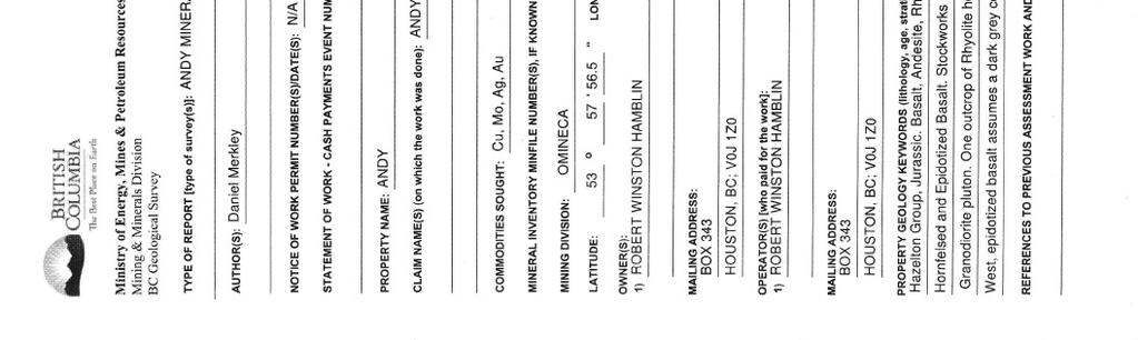
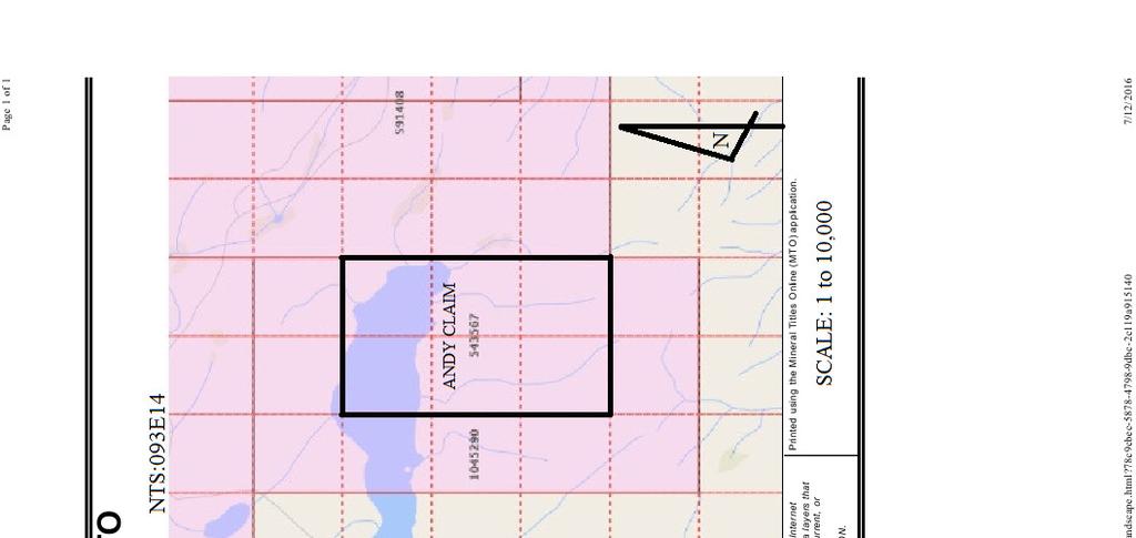
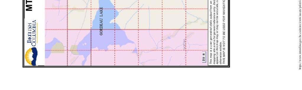
5 LOCATION: The Andy Property is located approximately 95 km southwest of Houston, British Columbia. The property location center is located on the National Topographic Map 093E95 at 53 o latitude north, 127 o 3 58 longitude west; Universal Tran Mercator, Zone 9: northing, easting. ACCESS: Beginning of the route to the Andy Property is located about 4 km west of Houston, British Columbia, on the Morice River Forest Access Road, which turns south off Highway 16 between the villages of Houston and Smithers; one then travels south on the Morice River-Owen-Nadina Roads to kilometer 74; turn west onto the Hill Tout Forest Service Road and travel for approximately 5 km to the Dual Lakes Forest Service Access Road; travel on the Dual Lake Road to 102 kilometer. At this point the gravel road branches, one road striking north, the other striking south. The southern branch provides access to the portion of the property where the rock samples discussed in this report were collected. HISTORY: 1994 Cominco Ltd. Airborne Magnetic, Electromagnetic, Radiometric and VLF-EM Survey 1997 Robert Hamblin 20-2 ¾ percussion holes (609.6 m) 1998 Robert Hamblin 15-2 ¾ percussion holes (457.2 m) 1999 Robert Hamblin 42-5cm percussion holes (1281 m)
6 TENURE STATUS: Ownership: Robert Hamblin 60% William Merkley 20% Daniel Merkley 20% NAME TENURE NUMBER OLD EXPIRY NEW EXPIRY ANDY /Jun/ /Oct/30 GEOLOGY: Intrusive rocks are represented by Granodiorite and Monzonite. Monzonite outcrops at the north-central sector of the property at one limited outcrop. At this single local it appears to be porphyritic. Granodiorite outcrops at the north-central sector and extends to the easterly border of the property and appears at several outcrop sites. The Monzonite porphyry appears to bear a greater proportion of molybdenite in hand specimens. Chalcopyrite with minor molybdenite occurs in stockwork at all outcrops of Granodiorite so far investigated. Volcanics and sediments are represented by a limited number of outcrops: (1) At the extreme northeast of the property a mauve andesite outcrops on a steep hill near the edge of Gordeau Lake. An area of Quartz stringers with minor Chalcopyrite outcrops over a limited area. (Location of some sampling in this report). (2) At the westerly central sector of the property a single outcrop of amber-coloured rhyolite hosts hematite and minor tetrahedrite. (3) At the center of the property several outcrops of chloritic hornfels
7 bear ubiquitous magnetite. This rock has been extensively altered, but the original rock could have been siltstone, perhaps of the Skeena or Kasalka groups. The volcanics would be assigned to the Lower Jurassic Telkwa Formation of the Hazelton Group. (4) To the east of Gordeau Lake a silicified green rhyolite outcrops over very restricted areas. The rock could in part a chloritized ambercoloured rhyolite and hosts chalcopyrite in rare quartz stringers.

8
9
10
11
12
13 ANDY PROPERTY 2016 SOIL SAMPLE VALUES AND GPS COORDINATES SAMPLE CU PPM NORTHING EASTING ANDY ANDY ANDY ANDY ANDY ANDY ANDY ANDY ANDY ANDY ANDY

14
15
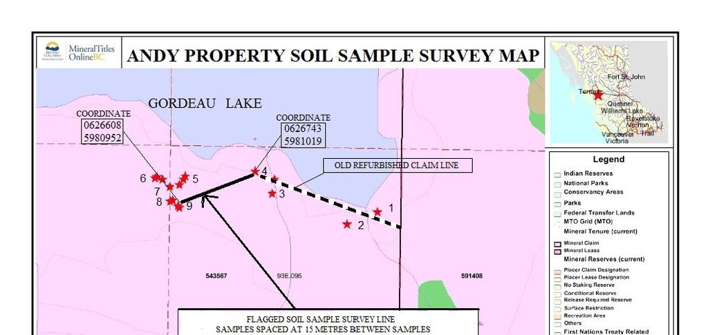
16 PURPOSE & PROCEDURE: On June 9th Robert Hamblin, William Merkley and Dan Merkley cleared brush and windfalls from an existing cut claim line on the Andy property. Date the original claim line was cut is unknown (cut during 2-post claim staking in the past, or an unknown survey). The line was refurbished to allow passage with a four-wheel ATV, so the original discoverer of the Andy mineralization who is unable to walk great distances could assist in the future soil sample program. On June 12th a soil sample survey was run between two mineralized outcrops which appear to be the most important. The samples were collected from the "B" horizon. It was noted that the samples gathered from the soutwest portion of the survey line were darker in colour, suggesting more humus content, while the samples from the northeast section were lighter-coloured and contained more gravel. The soil survey was conducted to find if mineral continuation between the two sites could be verified by anomalous copper content in the overlying soils when analysed. The samples were shipped on Grayhound Bus from Houston to the Terrace, British Columbia office of ALS Minerals. The samples were then pulverized and split, so 85% were <75 um. The soil samples were then analyzed by ME-ICP41 method for copper content. CONCLUSION: The copper analysis showed no significantly anomalous content in the collected samples. A few reasons for this negative result may be: The soil may contain too much clay, or is of too recent provenance to have allowed ionic transfer from buried mineralization; alternately, the underlying mineralization, being porphyritic and low-grade may not be detectable by soil sampling.
17 ANDY PROPERTY EXPEDITURES SENIOR $500/day x 3 men x 2 days $ PICKUP (4-wheel drive $75/day x 2 days $ PROVISIONS ($15/day x 3 men x 2 days $90.00 x 2 days $ x 2 x 2 $ SAMPLE PREPARATION & ANALYSIS $ REPORT PREPARATION $ TOTAL $4,690.00
18 AUTHOR'S OUALIFICATIONS I, I)aniel Merkley, do hereby certify that: (l) I arnaprospector and reside at 3313 Hw1' 16 E, Houston, B. C. (2)I have more than 40 years of prospecting experience (3) I am familiar with rock and soil geochemical sample collection (4) I prepared this report Respectfully submitted lntn *,,,'! 7J, 77*J,q Daniel Merkley / Prospector 13
HDN MINERAL PRO iperty
 HDN MINERAL PRO iperty ROCK SAMPLE GEOCHEMISTRY ASSESSMENT REPORT 2010 OMINECA MINING DIVISION, BRITISH COLUMBIA 93L047 LATITUDE: 54 29' 16.9" N LONGITUDE: 126 39' 39.8" W GPS: NAD 83 UTM ZONE 9 NORTHING:
ASSESSMENT REPORT TITLE PAGE AND SUMMARY
 ASSESSMENT REPORT TITLE PAGE AND SUMMARY TITLE OF REPORT: 2016 Prospecting Report Sphynx Claim TOTAL COST: $167.56 AUTHOR(S): Giacomo Grassi SIGNATURE(S): NOTICE OF WORK PERMIT NUMBER(S)/DATE(S): STATEMENT
ASSESSMENT REPORT. Geochemical and Geological Surveys. on the. Gooch#1-4. Mineral Claims. Omenica Mining District NTS 93L/7W
 f- GEOLOGICAL BRANCH ASSESSMENT REPORT ASSESSMENT REPORT Geochemical and Geological Surveys on the Gooch#1-4 Mineral Claims Omenica Mining District NTS 93L/7W LAT: 54O25'W LONG: 126O26'W Operator: SMD
ASSESSMENT REPORT TITLE PAGE AND SUMMARY
 ASSESSMENT REPORT TITLE PAGE AND SUMMARY TITLE OF REPORT: 2016 Prospecting Report Midas Claim TOTAL COST: $314.61 AUTHOR(S): Giacomo Grassi SIGNATURE(S): NOTICE OF WORK PERMIT NUMBER(S)/DATE(S): STATEMENT
ASSESSMENT REPORT TITLE PAGE AND SUMMARY
 ASSESSMENT REPORT TITLE PAGE AND SUMMARY TITLE OF REPORT: 2016 Prospecting Report Mystery Beryl TOTAL COST: $1299.09 AUTHOR(S): Giacomo Grassi SIGNATURE(S): NOTICE OF WORK PERMIT NUMBER(S)/DATE(S): STATEMENT
NEW HAZELTON, OMINECA M.D.,
 PROSPECTING REPORT JUDI 1 TO 6 MINERAL CLAIMS NEW HAZELTON, OMINECA M.D., B.C. MAP 93M/4E, LAT. SS014'N, LONG. 127'33'W OWNED BY: A. L'ORSA ANTHONY L'ORSA Smithers, B.C. 21 February, 1981 TABLE OF CONTENTS
PROSPECTORS ASSISTANCE PROGRAM MINISTRY OF ENERGY AND MINES
 BRITISH COLUMBIA PROSPECTORS ASSISTANCE PROGRAM MINISTRY OF ENERGY AND MINES GEOLOGICAL SURVEY BRANCH PROGRAM YEAR: 1999/2000 REPORT #: PAP 99-l 6 NAME: KIM ANSCHETZ PROSPECTORS TlEPORT on the 99 LOUIS
lat ' N Long ' W
 305 7 ec1;, REPORT ON THE JERY CLAIMS OF POLA RESOURCES LTD. NTS 93L/16 0 0 lat. 54 45' N Long. 126 22' W BABIXE LAKE AREA OMINECA MINING DIVISION, B.C. PAUL PLICKA CONSULTING GEOLOGIST DECEMBER 30, 1981
VICTORIA, BC FILE NO,
 FILE NO, VICTORIA, BC DEC - 7 2006 BFUTISH COLUMBIA Ministry of Energy & Mines Energy & Minerals Division Geological Survey Branch ASSESSMENT REPORT TITLE PAGE AND SUMMARY TITLE OF REPORT [type of survey(s)]
GEOLOGICAL MAPPING REPORT ON THE ASH MINERAL CLAIM OSOYOOS MINING DIVISION ASHNOLA RIVER MAP SHEET NTS M092,H019 MCBRIDE CREEK AREA, ASHNOLA RIVER,
 GEOLOGICAL MAPPING REPORT ON THE ASH MINERAL CLAIM OSOYOOS MINING DIVISION ASHNOLA RIVER MAP SHEET NTS M092,H019 LATITUDE 49 o O6, LONGITUDE 120 o 22 MCBRIDE CREEK AREA, ASHNOLA RIVER, KEREMEOS, B.C. CANADA
2013 GEOLOGICAL ASSESSMENT REPORT SHERIDAN HILL PROPERTY
 2013 GEOLOGICAL ASSESSMENT REPORT ON THE SHERIDAN HILL PROPERTY NEW WESTMINSTER MINING DIVISION BRITISH COLUMBIA NTS 092G07 49 16 31 NORTH LATITUDE, 122 39 48 WEST LONGITUDE PREPARED FOR Sheridan Hill
ASSESSMENT REPORT TITLE PAGE AND SUMMARY
 ASSESSMENT REPORT TITLE PAGE AND SUMMARY TITLE OF REPORT: Assessment Report on Andys Bridge Mineral Claim, Turnagain River Area TOTAL COST: $2,100 AUTHOR(S): Bruce w Downing SIGNATURE(S): Bruce W Downing
Montgomery Bedrock Geology 21d-Gowganda Formation: conglomerate, sandstone, siltstone, argillite
 Work Report 2014 Trenching Montgomery Township G-3303 Claim #4259384,4245818 Sault Ste. Marie Mining Division Michael & Yvon Gagne Montgomery Copper Property 1 P a g e 2 P a g e Montgomery Bedrock Geology
NOTICE OF WORK PERMIT NUMBER(S)/DATE(S):
/DATE(S):") Ministry of Energy and Mines BC Geological Survey Assessment Report Title Page and Summary TYPE OF REPORT [type of survey(s)]: Technical Reporting (mineral claim) TOTAL COST: $2,200.00 AUTHOR(S): Craig
Ministry of Energy and Mines BC Geological Survey Assessment Report Title Page and Summary TYPE OF REPORT [type of survey(s)]: Technical Reporting (mineral claim) TOTAL COST: $2,200.00 AUTHOR(S): Craig
Structural Analysis Using Hillshade Imagery. on the. LLC Property
 Structural Analysis Using Hillshade Imagery on the LLC Property Liard Mining Division NTS 104F/16W Latitude: 57 53' 47'' N Longitude: 132 03' 06'' W Owner Garry John Payie 3714 Raymond Street South, Victoria,
UNION MINIERE EXPLORATIONS AND MINING CORPORATION LIMITED ASSESSMENT REPORT ON FITINAT MINERAL CLAIM. Alberni Mining Division Record No.
 M F )( UNION MINIERE EXPLORATIONS AND MINING CORPORATION LIMITED Suite 200, 4299 Canada Way, Burnaby, B.C. V5G 1 H4 Telephone (604) 437-9491 ASSESSMENT REPORT ON GEOCHEMICAL SOIL SURVEYS AND ROCKSAMPLING
The Cobalt Rainbow. Airborne geophysical maps show that a north trending aeromagnetic high suggests further undiscovered mineralisation.
 The Cobalt Rainbow The property is located on Greenstone Creek, approximately 4.8 kilometres south west of the creek mouth. The property is located about 24 km due west of Campbell River, in the east-central
ASSESSMENT REPORT ON THE PEAVINE PROJECT. DGW & Associates # Alberni Street, Vancouver, British Columbia, V6E 4V2
 ASSESSMENT REPORT ON THE PEAVINE PROJECT KAMLOOPS MINING DIVISION BRITISH COLUMBIA NTS 082M 12 Latitude 51 36' 19.0"North -- Longitude --119 47' 27.0"West UTM Zone 11, NAD 83 5720827N 306744E Prepared
ON THE LOST GOLD PROPERTY
 ON THE LOST GOLD PROPERTY NELSON MINING DIVISION BRITISH COLUMBIA Latitude: 49 18 North Longitude: 117 29.West TRIM MAPS: 82F1023,033 NTS: 8tF/5,6 By: Fred Critchlow . TABLE OF CONTENTS r PAGE lutroduction
for the Greenwood Mining Division, B.C. NTS 82E/7W Latitude 49' 27' W, Longitude 118' 5 Prepared by a= D. Dylan Watt, B.Sc.
 t. b LOGnO: 37~ -08 m. ACTIO#: for the AMP AMP 2 AMP 3 t AMP 4 CLAIMS Greenwood Mining Division, B.C. NTS 82E/7W Latitude 49' 27' W, Longitude 8' 5 %E c,w zc *& a w Prepared by a= -4c. D. Dylan Watt, B.Sc.
ASX Announcement. 28 January Drill results indicate large Porphyry Copper Gold System at Peenam
 ASX Announcement 28 January 2010 Drill results indicate large Porphyry Copper Gold System at Peenam Highlights: 270 metres of visible copper (gold) mineralisation in first diamond core hole at Peenam Prospect
O ITHIS )WE OF WORK IN I EXTENT OF WORK I I PROJECT COSTS I ON WHICH CLAIMS (IN METRIC UNITS) APPORTIONED (id. support) GEOLOGICAL (scale, area)
WE OF WORK IN I EXTENT OF WORK I I PROJECT COSTS I ON WHICH CLAIMS (IN METRIC UNITS) APPORTIONED (id. support) GEOLOGICAL (scale, area)") Geological Survey Branch TITLE OF REPORT [type of SUNOY(S)] TOTAL COST 1 MINERAL INVENTORY M OWNER@) MAILING ADDRESS -.,-- a 5 -a OPERATOR(S) [who paid ffo the wnk) 2) MAILING ADDRESS 76e2 HWY 97/gm LP
Geological Survey Branch TITLE OF REPORT [type of SUNOY(S)] TOTAL COST 1 MINERAL INVENTORY M OWNER@) MAILING ADDRESS -.,-- a 5 -a OPERATOR(S) [who paid ffo the wnk) 2) MAILING ADDRESS 76e2 HWY 97/gm LP
Diamond Drilling Report. on the
 Diamond Drilling Report on the CR Mineral Property Omineca Mining Division, British Columbia NTS 093L/07W Latitude 54" 17' N, Longitude 126" 50' W for John Wesley Moll ~~, PO Box 1182, Houston, Be,, ~..._1*,.
NOTICE OF WORK PERMIT NUMBER(S)/DATE(S):
/DATE(S):") Ministry of Energy, Mines & Petroleum Resources Mining & Minerals Division BC Geological Survey Assessment Report Title Page and Summary TYPE OF REPORT [type of survey(s)]: TOTAL COST: AUTHOR(S): SIGNATURE(S):
Ministry of Energy, Mines & Petroleum Resources Mining & Minerals Division BC Geological Survey Assessment Report Title Page and Summary TYPE OF REPORT [type of survey(s)]: TOTAL COST: AUTHOR(S): SIGNATURE(S):
First Year assessment Report on Prospecting and Rock sampling, King George property, License M NTS 12A/05 Newfoundland and Labrador.
 First Year assessment Report on Prospecting and Rock sampling, King George property, License 016679M NTS 12A/05 Newfoundland and Labrador. Submitted by Shawn Rose For Shawn Rose January 2011 Work year
, , ,
 Ministry of Energy and Mines BC Geological Survey Assessment Report Title Page and Summary TYPE OF REPORT [type of survey(s)]: Airborne Geophysic TOTAL COST: 9,4. AUTHOR(S): Walcott, A. Walcott, P SIGNATURE(S):
4J)SESSMEN'I' REPORT BRANCH. cc" FILE No: ASSESSMENT REPORT VICTORIA MINING DIVISION. Latitude 123O SF' Longitude 48O S5'
SESSMEN'I' REPORT BRANCH. cc FILE No: ASSESSMENT REPORT VICTORIA MINING DIVISION. Latitude 123O SF' Longitude 48O S5'") ASSESSMENT REPORT - ON THE ORM 1 MINERAL CLAIM VICTORIA MINING DIVISION NTS 92B cc" Latitude 123O SF' Longitude 48O S5' 3-2. w N C FILE No: @&@LOGI.CAL BRANCH 4J)SESSMEN'I' REPORT Date : June 1, 1990 TABLE
ASSESSMENT REPORT - ON THE ORM 1 MINERAL CLAIM VICTORIA MINING DIVISION NTS 92B cc" Latitude 123O SF' Longitude 48O S5' 3-2. w N C FILE No: @&@LOGI.CAL BRANCH 4J)SESSMEN'I' REPORT Date : June 1, 1990 TABLE
ASSESSMENT REPORT GEOLOGICAL BRANCH. 50' 23 'North. GEOLOGICAL and GEOCHEMICAL SURVEYS ON THE. PUTNAM PROPERTY (Putnam Mineral Claim)
") GEOLOGICAL and GEOCHEMICAL SURVEYS ON THE PUTNAM PROPERTY (Putnam Mineral Claim) VERNON MINING DIVISION, B.C. GEOLOGICAL BRANCH ASSESSMENT REPORT NTS : Latitude: 82L17W 50' 23 'North LOCATION, ACCESS,
GEOLOGICAL and GEOCHEMICAL SURVEYS ON THE PUTNAM PROPERTY (Putnam Mineral Claim) VERNON MINING DIVISION, B.C. GEOLOGICAL BRANCH ASSESSMENT REPORT NTS : Latitude: 82L17W 50' 23 'North LOCATION, ACCESS,
Airborne Geophysical TOTAL COST: $8, ,
 Ministry of Energy, Mines & Petroleum Resources Mining & Minerals Division BC Geological Survey Assessment Report Title Page and Summary TYPE OF REPORT [type of survey(s)]: Airborne Geophysical TOTAL COST:
PROSPECTING REPORT. Medallion Property. EVENT # TENURE # Tenure Name: GPEX CLVIII Medallion
 2006-2007 PROSPECTING REPORT Medallion Property EVENT # 4167980 TENURE # 540362 Tenure Name: GPEX CLVIII Medallion Watson Bar Region Clinton Mining Division Map 092O Central Coordinate Reference Long.
R.A. COMINCO LTD. EXPLORATION NTS: 92H/16. WESTERN DISTRICT January 6, 1982 ASSESSMENT REPORT 1981 SOIL GEOCHEMISTRY ON THE TROUT PROPERTY
 COMINCO LTD. EXPLORATION NTS: 92H/16 WESTERN DISTRICT January 6, 1982 ASSESSMENT REPORT 1981 SOIL GEOCHEMISTRY ON THE TROUT PROPERTY (Trout 1 and 6 Claims) SIWASH LAKE AREA, SIMILKAMEEN M.D., B.C. (Work
for the Greenwood Mining Division, B.C. NTS 82E/7W 29' W, Longitude 118' 53' N Prepared by D. Dylan Watt, B.Sc.
 for the FltE NO: u VOLT 1, VOLT 2, VOLT 3, & VOLT 4 CLAIMS Greenwood Mining Division, B.C. NTS 82E/7W Latitude 49' 29' W, Longitude 118' 53' N Prepared by D. Dylan Watt, B.Sc. #309-1996 Trutch Street Vancouver,
PROSPECTING REPORT. Silver Dollar Property. EVENT # TENURE # Tenure Name: GPEX Silver Dollar
 2008-2009 PROSPECTING REPORT Silver Dollar Property EVENT # 4267989 TENURE # 555462 Tenure Name: GPEX Silver Dollar Similkameen Mining Division Map 092H Central Coordinate Reference 120 06 26.9 W Longitude
1 FILMED 1. FILE NO:!..rsrru -* -. GRAND TWO CLAIM
 FILE NO:!..rsrru -* -. GRAND TWO CLAIM REPORT ON 1993 ASSESSMENT WORK GRAND TWO CLAIM REC. NO. 301849 NELSON MINING DIVISION NTS MAP SHEET 82F6/W 49 25'51" NORTH 117 18'08" WEST 1 FILMED 1 AUTHOR: R. Jordan,
Summary of Rover Metals Geologic Mapping Program at the Up Town Gold Project, Northwest Territories
 October 13, 2017 Summary of Rover Metals Geologic Mapping Program at the Up Town Gold Project, Northwest Territories Vancouver, British Columbia, Canada - Rover Metals Corp., Rover, is pleased to provide
The MAPLE BAY PROJECT Copper Silver - Gold
 The MAPLE BAY PROJECT Copper Silver - Gold Good grade and tonnage potential within close proximity to Tidewater The Maple Bay Copper Silver Gold Project covers highly favourable geological host rocks of
Beekeeper Property The Geology South of Mint Lake. Cariboo Mining Division
 Beekeeper Property The Geology South of Mint Lake NTS: 93A/6 Cariboo Mining Division Claims: Beekeeper 1 #I2055 Beekeeper 2 #3892 Beekeeper 3 #7895 Beekeeper 4 #8503 Latitude: Longitude: 52 degrees 24
BALFOUR MINING LTD. (N.P.L.) HAM GROUP 92-P-6, CLINTON M. D.8 B. C. Lat 51 17'N, GEOCHEMICAL REPORT. V. CUKOR, P. Eng.
 HAM GROUP 92-P-6, CLINTON M. D.8 B. C. Lat 51 17'N, GEOCHEMICAL REPORT. V. CUKOR, P. Eng.") 34q '7 BALFOUR MINING LTD. (N.P.L.) HAM GROUP 92-P-6, CLINTON M. D.8 B. C. Lat 51 17'N, Long 12lo14'W GEOCHEMICAL REPORT, V. CUKOR, P. Eng. January 31, 1972 TABLE OF CONTENTS 1. INTRODUCTION 2. PROPERTY,
34q '7 BALFOUR MINING LTD. (N.P.L.) HAM GROUP 92-P-6, CLINTON M. D.8 B. C. Lat 51 17'N, Long 12lo14'W GEOCHEMICAL REPORT, V. CUKOR, P. Eng. January 31, 1972 TABLE OF CONTENTS 1. INTRODUCTION 2. PROPERTY,
Reconnaissance. Of the. Denis mineral claims. Situated at Kilometer 844 of the Alaska Highway. Liard Mining Division. Northeastern British Columbia
 Reconnaissance Of the Denis mineral claims Situated at Kilometer 844 of the Alaska Highway Liard Mining Division Northeastern British Columbia N.T.S. 94M.075 Latitude 59 42 25 Longitude 127 13 12 Field
BCGold Corp. Discovery Driven
 BCGold Corp. Discovery Driven Sickle-Sofia Property Copper-Gold Porphyry Discovery in the Toodoggone Camp! Cautionary Statement This presentation does not constitute an offer to sell or solicitation of
RECONNAISSANCE GEOCHEMICAL SURVEY
 RECONNAISSANCE GEOCHEMICAL SURVEY LEGAL, RITA, LOUISE FR. (CHAPLEAU GROUP) REVERTED CROWN GRANTS CHAPLEAU CREEK AREAJ, SLOC& MINING DIVISION 82 F/11W Lat: 49'44" Long: 117"22'W MINERAL RESOURCES BRANCH
REPORT. on the. Omineca Mining Division, British Columbia. Latitude N., Longitude W. NTS map sheet 93F/7E. James W. McLeod, P.Geo.
 REPORT on the CHU MOLYBDENUM PROPERTY Omineca Mining Division, British Columbia Latitude 53 21 N., Longitude 124 37 W. NTS map sheet 93F/7E James W. McLeod, P.Geo. on behalf of Mr. Chris Delorme TABLE
3 I1 I I Ill 111 II! II 111 II Ill I IlE I I P I
 -7 3 1 1 11111111111111111111111111111111 ll 111! 111 111 111 111 111111111111111 ll 1111111 1 11111111111111 le P GEOCHEMCAL SURVEY OF THE KE AND D'ARCY CLAM GROUPS.. Similkameen Mining Division, B.C.
PIOTR LUTYNSKI VANCOUVER, BRITISH COLUMBIA
 AN ASSESSMENT REPORT ON GROUND MAGNETIC SURVEYING CHUCHI PROPERTY FORT ST. JAMES AREA, BRITISH COLUMBIA OMINECA M.D. 55 17 N, 124 31 W NTS 93N/ 7&8 Claims Surveyed: 597976, 597878-597880 Survey Dates:
HD MINERAL PROPERTY ASSESSMENT REPORT FOR THE 2009 ROCK GEOCHEMISTRY AND ROAD WORK NTS 93L047 LATITUDE: 54'27" LONGITUDE: 126'39 H
 HD MINERAL PROPERTY TRANS # ASSESSMENT REPORT FOR THE 2009 ROCK GEOCHEMISTRY AND ROAD WORK RECEIVED SERVICE BC SMiTHERS JAN 2 2 2010 NOT AN OFFICIAL RECEIPT MINERAL TITLES BRANCH [File Rsc'd : '
SECOND and THIRD YEAR ASSESSMENT REPORT PROSPECTING LICENCE M, ROCK CUT PROPERTY, NTS 1N/12, NEWFOUNDLAND. ROY FRENCH (licence holder )
") SECOND and THIRD YEAR ASSESSMENT REPORT Of PROSPECTING On LICENCE 013704M, ROCK CUT PROPERTY, NTS 1N/12, NEWFOUNDLAND. By ROY FRENCH (licence holder ) Work Conducted: Sept. 17, 2008 Nov. 03, 2009 Total
SECOND and THIRD YEAR ASSESSMENT REPORT Of PROSPECTING On LICENCE 013704M, ROCK CUT PROPERTY, NTS 1N/12, NEWFOUNDLAND. By ROY FRENCH (licence holder ) Work Conducted: Sept. 17, 2008 Nov. 03, 2009 Total
Mountain Maid Gold System Displays Major Size Potential
 29 July 2008 The Manager, Companies Australian Securities Exchange Ltd Electronic Announcement System Dear Sir, AXIOM MINING LIMITED (ASX CODE: AVQ) ASX Announcement Mountain Maid Gold System Displays
DISCOVERY OF MINERALISED PORPHYRY & MAGNETITE-COPPER-GOLD AT KAMARANGAN
 MEDUSA MINING LIMITED ABN: 60 099 377 849 Unit 7, 11 Preston Street Como WA 6152 PO Box 860 Canning Bridge WA 6153 Telephone: +618-9367 0601 Facsimile: +618-9367 0602 Email: admin@medusamining.com.au Internet:
E: 54 25' 47.5" N $ g.:
 ASSESSMENT REPORT FOR 2008 DRILLING REPORT OF THE CHINA KNOWS 3-565612 MINERAL CLAIMS ING DIVISION &;. "< @, ' 5..i s. i'. :+,!a,-:.,.,. E: 54 25' 47.5" N $ g.: *>,- 7 '.. L - L' WORK DONE BY: JOHN WESLEY
For personal use only
 ANNOUNCEMENT TO THE AUSTRALIAN SECURITIES EXCHANGE: 28 NOVEMBER 2012 DRILLING UPDATE MABILO PROJECT The Directors of Sierra Mining Limited ( Sierra ) are pleased to announce further results from reconnaissance
REPORT ON GEOCHEMICAL AND GEOLOGICAL EXPLORATION PROGRAM WITH BACKHOE TRENCHING IRK CLAIMS LONGITUDE 126~38'
 REPORT ON GEOCHEMICAL AND GEOLOGICAL EXPLORATION PROGRAM WITH BACKHOE TRENCHING IRK CLAIMS LATITUDE 54O12' LONGITUDE 126~38' By R. E. GALE AS ARC0 EXPLORATION COMPANY OF CANADA LTD. AUGUST 22, 1984 GEOLOGICAL
NTS 93L/9W GEOCHEMICAL AND GEOPHYSICAL REPORT MONA CLAIM OMINICA MINING DIVISION. Lati tude 54036'N; Longitude 'W
 GEOCHEMICAL AND GEOPHYSICAL REPORT ON MONA CLAIM OMINICA MINING DIVISION Lati tude 54036'N; Longitude 126018'W NTS 93L/9W April 1981 Paul Plicka Consulting Geologist LOCATION MAP INTRODUCTION TABLE OF
COMBINATION OF MMI AND ENZYME LEACH METHODS IN EXPLORATION FOR GOLD IN AN AREA OF THE CANADIAN SHIELD COVERED WITH GLACIAL SEDIMENTS: A CASE STUDY
 COMBINATION OF MMI AND ENZYME LEACH METHODS IN EXPLORATION FOR GOLD IN AN AREA OF THE CANADIAN SHIELD COVERED WITH GLACIAL SEDIMENTS: A CASE STUDY Nadia Yavorskaya 450 Bonner Ave., Winnipeg, MB, Canada
ASSESSMENT REPORT N 0. REPORT ON HORIZONTAL COPLANAR LOOP ELECTROMAGNETIC SURVEY HOUSTON AREA OF BRITISH COLUMBIA AQUITAINE COMPANY OF CANADA DURING
 tf 62 33 REPORT ON HORIZONTAL COPLANAR LOOP ELECTROMAGNETIC SURVEY IN THE HOUSTON AREA OF BRITISH COLUMBIA BY AQUITAINE COMPANY OF CANADA c DURING MARCH 21 - MARCH 25, 1977 MINERAL RESOURCES BRANCH ASSESSMENT
SUPPLEMENT TO MAGNETOMETER 6 ELECTROMAGNETIC SURVEY REPORT. DATED NOVEMBER l, 1973 CIGLEN INVESTMENTS LIMITED CLAIMS GROUP BAD VERMILLION LAKE AREA
 ^ A R l ^ 1974 010 PROJECTS UNIT SUPPLEMENT TO MAGNETOMETER 6 ELECTROMAGNETIC SURVEY REPORT DATED NOVEMBER l, 1973 CIGLEN INVESTMENTS LIMITED CLAIMS GROUP BAD VERMILLION LAKE AREA DISTRICT OF RAINY RIVER
ASSESSMENT REPORT ON THE VLF-EM SURVEY. Trail Creek Mining Division NTS: 82 F/4 W Longitude: 1 17' 49' 50" Latitude: 49O 03' 40"
 ASSESSMENT REPORT ON THE JERO 5 MINERAL CLAIM ROSSLAND, BRJTISH COLUMBIA VLF-EM SURVEY Trail Creek Mining Division NTS: 82 F/4 W Longitude: 1 17' 49' 50" Latitude: 49O 03' 40" Owner: Operator: Author:
A GUIDE TO WRITING AN ASSESSMENT REPORT ON YOUR CLAIMS
 A GUIDE TO WRITING AN ASSESSMENT REPORT ON YOUR CLAIMS PLEASE NOTE! In the following pages, suggestions and advice are in italics, under each heading. Use as a guideline only. Items in bold should be changed
GEOPHYSICAL ASSESSMENT REPORT (TOP & BOTTOM CLAIMS) MCINTYRE LAKE. VERNON MINING DIVISION, B-Cm
 MCINTYRE LAKE. VERNON MINING DIVISION, B-Cm") GEOPHYSICAL ASSESSMENT REPORT on the TOP PROPERTY (TOP & BOTTOM CLAIMS) MCINTYRE LAKE VERNON MINING DIVISION, B-Cm NTS : Latitude: 50'04' North Longitude: Owner: Consultant : Author : 118'33 ' West Brican
GEOPHYSICAL ASSESSMENT REPORT on the TOP PROPERTY (TOP & BOTTOM CLAIMS) MCINTYRE LAKE VERNON MINING DIVISION, B-Cm NTS : Latitude: 50'04' North Longitude: Owner: Consultant : Author : 118'33 ' West Brican
TOPOGRAPHICAL SURVEY REPORT ON THE GREENDROP PROPERTY NEAR CHILLIWACK, B.C. 92-H-3/W
 TOPOGRAPHICAL SURVEY REPORT ON THE GREENDROP PROPERTY NEW WESTMINSTER M.D. NEAR CHILLIWACK, B.C. 92-H-3/W Location: The central pap of the claims is located at coordinates 49 08'N, latitude by 121 26'W,
News Release No GOLD AND COPPER MINERALIZATION DISCOVERED DURING PHASE 2 EXPLORATION AT THE MCBRIDE PROPERTY
 November 19, 2018 TSX Venture Exchange Listed Frankfurt Exchange Listed News Release No. 303-2018 GOLD AND COPPER MINERALIZATION DISCOVERED DURING PHASE 2 EXPLORATION AT THE MCBRIDE PROPERTY Vancouver,
Prospecting Report 'S Office i DB Property, B.C. -J Negro Creek Nelson Mining District NTS 82F.050. Operator: Kootenay Gold Inc.
 . '.' I"' i9 12 Prospecting Report 'S Office i DB Property, B.C. -J Negro Creek Nelson Mining District NTS 82F.050 Operator: Kootenay Gold Inc. Owner: Darlene Lavoie Work Performed Summer of 2007 Report
BALTO RESOURCES LTD. (Owner & Operator) GEOPHYSICAL ASSESSMENT REPORT. (Event Number ) on the SED MINERAL CLAIM.
 GEOPHYSICAL ASSESSMENT REPORT. (Event Number ) on the SED MINERAL CLAIM.") BALTO RESOURCES LTD. (Owner & Operator) GEOPHYSICAL ASSESSMENT REPORT (Event Number 5173274) on the SED MINERAL CLAIM (Tenure 392163) Kamloops Mining Division NTS 092I.047 Centre of Work 5589550N, 667600E
BALTO RESOURCES LTD. (Owner & Operator) GEOPHYSICAL ASSESSMENT REPORT (Event Number 5173274) on the SED MINERAL CLAIM (Tenure 392163) Kamloops Mining Division NTS 092I.047 Centre of Work 5589550N, 667600E
The survey covered claims, in part or in full, DUCKLING 3, 4, 5, 4 fraction, and 5 fraction.
 514 687-6671 XXX- 602 West Hastin~a StroeP, Vata;sn@ouver, BritlsA fhlum~b~a, Garaadsa B81apphgtaa DISCUSS ION OF MAGNETOMETER SURVEY ON DUCKLING CLAIMS FOR DONNA MINES LTD. (N0P.L.) Submitted to: DONNA
PRECIOUS METALS. owner. JMT Services Corp. GEOCHPlICAL SAMPLING CHELASLIE WCE, NORTH CENTRAL, B.C. OMINECA MINING DIVISION NTS 93F/5E & 6W
 PRECIOUS METALS REPORT ON 1980 RECONNAISSANCE GEOCHPlICAL SAMPLING CHELASLIE WCE, NORTH CENTRAL, B.C. OMINECA MINING DIVISION NTS 93F/5E & 6W LATITUDE 53O28 N LONGITUDE 125O31 W DATES Qp WORK: JULY 10
BRITISH COLUMBIA PROSPECTORS ASSISTANCE PROGRAM MINISTRY OF ENERGY AND MINES GEOLOGICAL SURVEY BRANCH:
 BRITISH COLUMBIA PROSPECTORS ASSISTANCE PROGRAM MINISTRY OF ENERGY AND MINES GEOLOGICAL SURVEY BRANCH: PROGRAM YEAR 1998199 REPORT #: PAP 98-27 DAN NAME: ~ BRITISH ~.' ~..~. :. ~.,.. * ~... i.~ -,.,/ >.
CARIBOO - GRIZZLY ZINC PROJECT
 CARIBOO - GRIZZLY ZINC PROJECT The Grizzly Lake or Cariboo Zinc property straddles the gravel Weldwood 8400 logging road in the Grizzly Lake area about 55 kilometres northeast of Likely. Roads constructed
Pacific Empire Minerals Provides Copper King RC Drilling Results
 Pacific Empire Minerals Provides Copper King RC Drilling Results November 1, 2018 - Vancouver, BC, Canada - Pacific Empire Minerals Corp. (TSXV: PEMC) ( Pacific Empire, PEMC or the Company ), a hybrid
W. 1.NELSON Jr. P. ENG.
 GEOCHEMICAL AND GEOPHYSICAL SURVEY SNO GROUP CLAIMS W. 1.NELSON Jr. P. ENG. NORANDA EXPLORATION COMPANY, LIMITED OMINECA MINING DIVISION AUG. 17, 1971 - AUG. 29, 1971 TABLE OF CONTENTS - Page INTRODUCTION
POTENTIAL OF THE DONGWE COPPER GOLD PROJECT
 POTENTIAL OF THE DONGWE COPPER GOLD PROJECT By Nathan Sabao, P.Geo. September 2015 1 TABLE OF CONTENTS Page 1.0 EXECUTIVE SUMMARY 1 2.0 LOCATION 2 3.0 ACCESS 2 4.0 GEOLOGY 3 5.0 PREVIOUS DRILLING 5 6.0
PHYSICAL WORK REPORT. the BAY CLAIMS. Omineca Mining Division Smithers, British Columbia N.T.S. 93E 13E/W
 PHYSICAL WORK REPORT the BAY CLAIMS Omineca Mining Division Smithers, British Columbia a N.T.S. 93E 13E/W LATITUDE: 53 57 00 N I LONGITUDE: 127 45 OO W for Home Ventures Ltd. 1201-675 West Hastings Street
Mineral Titles Online
 https://www.mtonline.gov.bc.ca/mto/jsp/sow_m_c/soweventconfirmation.jsp?ca.bc.gov.e... Page 1 of 2 1/20/2010 Mineral Titles Online Mineral Claim Exploration and Development Work/Expiry Date Change Recorder:
HOWE COPPER MINE PROJECT HIGH GRADE Cu-Ag with Au
 HOWE COPPER MINE PROJECT HIGH GRADE Cu-Ag with Au The Howe Copper Mine property is located approximately 55 kilometres northwest of Vancouver, BC. It is situated at 1431 metres elevation on the eastern
sq N & %%.& GEOPHYSICAL CONSULTING rr SERVICES LTD. $%& Long. 118o3OtW N.T.S. 82 E/15 -I- AUTROR: Glen E. Whi*e, B.Sc., P. %g.
 -\ GEOCHEMICAL EXPORT.,~.,~..'.. AMORE MINERALS 1NCORPOR;ITZC,' ~. 3rd fl5 Geo 3. and 2 mineral claims, Vernon- ~ $lining Division, B. C. Lat. 49 47'T?,,/ Long. 118o3OtW N.T.S. 82 E/15 -I- AUTROR: Glen
Prospecting Report Moore Creek
 Prospecting Report Moore Creek Area {.% \..\ F' -2 Assessment Report 4 Anthony L'Orsa, PGeo 7 October 2004 TABLE OF CONTENTS Page SUMMARY... INTRODUCTION... DISCLAIMER... LOCATION AND ACCESS... PHYSIOGRAPHY
1 CLAIMS GEOPHYSICAL REPORT ON BOYAL SITUATE NORTHEAST OF TILLICUM MOUNTAIN GOLD AREA BURTON - NAKUSP SIQCAEJ MINING DIVISION
 GEOPHYSICAL REPORT ON BOYAL 1 CLAIMS SITUATE NORTHEAST OF TILLICUM MOUNTAIN GOLD AREA BURTON - NAKUSP SIQCAEJ MINING DIVISION CONSULTING GEOLOGIST AUGUST 1983 VANCOUVER B *C INDEX INTRODUCTION ooa,.eoaaa.aaaoaaooaoa~ao~o
TITLE PAGE PROSPECTING REPORT. on the. Slil\lTINEL PEAK MINERAL CLAIM KENNEDY RIVER AREA. hlbehii1 MINING DIVISION NTS 92 F/6
 TITLE PAGE PROSPECTING REPORT on the Slil\lTINEL PEAK MINERAL CLAIM KENNEDY RIVER AREA hlbehii1 MINING DIVISION NTS 92 F/6 Latitude 49' 15' Longitude 125' 22' Walter Guppy Owner and operator TABLE OF COBTENTS
IVANHOE MINES LTD ACQUIRES FOUR NEW COPPER-GOLD PROJECTS IN MONGOLIA
 News Release October 15, 2001 IVANHOE MINES LTD ACQUIRES FOUR NEW COPPER-GOLD PROJECTS IN MONGOLIA SINGAPORE - Ivanhoe Mines Chairman Robert Friedland and Senior Vice-President, Exploration, Douglas Kirwin
GEOLOGICAL BRANCH ASSESSMENT REPORT
 GEOLOGICAL BRANCH ASSESSMENT REPORT REPORT ON GEOPHYSICAL GROUND SURVEYS ON THE CHILI CLAIM MAGNETIC, VLF DIP ANGLE ELECTROMAGNETIC, AND VLF RESISTIVITY SURVEYS BY HI LIMION SEPTEMBER 12, 1986 &! FILMED
BALTO RESOURCES LTD. (Owner & Operator) GEOPHYSICAL ASSESSMENT REPORT. (Event Number ) on the SED MINERAL CLAIM.
 GEOPHYSICAL ASSESSMENT REPORT. (Event Number ) on the SED MINERAL CLAIM.") BALTO RESOURCES LTD. (Owner & Operator) GEOPHYSICAL ASSESSMENT REPORT (Event Number 4829051) on the SED MINERAL CLAIM (Tenure 392163) Kamloops Mining Division NTS 092I.047 Centre of Work 5590150N, 678800E
BALTO RESOURCES LTD. (Owner & Operator) GEOPHYSICAL ASSESSMENT REPORT (Event Number 4829051) on the SED MINERAL CLAIM (Tenure 392163) Kamloops Mining Division NTS 092I.047 Centre of Work 5590150N, 678800E
%+ '$# $) %, %*$ " $ $ ' %' !()'-!" %( %"%! " *'+ - % %$! $)! " $)!" !$ ' "! )( ! $ '%& ')- % % "!#( (( ((# $) ' ) ((* & *# ' % %"*# ( !!
 %, %*$ $ $ ' %' !()'-! %( %%! *'+ - % %$! $)! $)! !$ ' ! )( ! $ '%& ')- % % !#( (( ((# $) ' ) ((* & *# ' % %*# ( !!") 001L/14/0218 First Year Assessment Report of Prospecting, Rock and Stream Sediment Sampling On Licence 18880M, NTS 1L/14 Burin Peninsula Newfoundland and Labrador Submitted by: Keith Kelloway Work year:
001L/14/0218 First Year Assessment Report of Prospecting, Rock and Stream Sediment Sampling On Licence 18880M, NTS 1L/14 Burin Peninsula Newfoundland and Labrador Submitted by: Keith Kelloway Work year:
ASSESSMENT REPORT I.P./RESISTIVITY AND MAGNETICS SURVEY ON THE HAUTETE PROPERTY LATITUDE: 55O 12' N LONGITUDE: 126O 07' W
 NTS: 93W1 ASSESSMENT REPORT I.P./RESISTIVITY AND MAGNETICS SURVEY ON THE HAUTETE PROPERTY LATITUDE: 55O 12' N LONGITUDE: 126O 07' W OMINECA MINING DISTRICI'. B.C. CLAIMS COVERED : TET 1-8 TIME PERIOD:
T. R. B. Dundas, P.Geoph., G. A. Nolin, P. Geol., Box th Avenue S.W., Calgary, Alberta T2P 4H3
 SELF-POTENTIAL SURVEY over the SUSAP PROPERTY Keremeos District Osoyoos Mining Division British Columbia Prepared for: Best Chance Exploration 531-6th Street Canmore, Alberta TIW 2C9 By: T. R. B. Dundas,
FIRST YEAR ASSESSMENT REPORT PROSPECTING LICENCE 16512M MARYSTOWN AREA, BURIN PENINSULA NTS 1M/3
 FIRST YEAR ASSESSMENT REPORT OF PROSPECTING ON LICENCE 16512M MARYSTOWN AREA, BURIN PENINSULA NTS 1M/3 BY NATHANIEL NOEL MSc. FOR E. MICHELE NOEL MINERAL LICENCES: 16512 M WORK CONDUCTED: MID-SEPTEMBER
BLURTON CREEK NICKEL PROPERTY. (Minfile # 082LNW-039)
") 5489153 BLURTON CREEK NICKEL PROPERTY (Minfile # 082LNW-039) Mara Lake Area / Salmon Arm B.C NTS - 82L-11 (UTM 83/Z10, 357690E, 5614220N) Prepared by: Jim Cuttle, B.Sc., P.Geo. 86 Cloudburst Road Whistler,
5489153 BLURTON CREEK NICKEL PROPERTY (Minfile # 082LNW-039) Mara Lake Area / Salmon Arm B.C NTS - 82L-11 (UTM 83/Z10, 357690E, 5614220N) Prepared by: Jim Cuttle, B.Sc., P.Geo. 86 Cloudburst Road Whistler,
VANCOUVER, B.C. Tri 082F/ F/059
 GEOCHEMCAL REPORT t MAY L, 2006 Whbpper Mineral Claims Ailsa Lake Area Gold comm~ss16fl8f"s Offim on Mining Division VANCOUVER, B.C. Tri 082F/058 082F/059 3792 E 5486438 N Operator Kootenay Gold nc. Suite
Soil Geochemical Sampling TOTAL COST: 10, F 059
 Ministry of Energy, Mines & Petroleum Resources Mining & Minerals Division BC Geological Survey Assessment Report Title Page and Summary TYPE OF REPORT [type of survey(s)]: Soil Geochemical Sampling TOTAL
PROSPECTING REPORT. re. Minera.1 C laims
 PROSPECTING REPORT re. Minera.1 C laims P R 1 Record #3052 (6) P R 2 Record #3053 (6) p R 3 Record #3054 (6) at Ilong.129, Latt. 58 20' in the Two Mile Creek area of Turnagain River drainage system in
FILE NO. ASSESSMENT REPORT VLF-EM GEOPHY S I CS BUCK CLAIMS. Moyie River and Perry Creek Area FORT STEELE MINING DIVISION. NTS 82 F/8 E and 82 G/5 W
 FILE NO. ASSESSMENT REPORT on - VLF-EM GEOPHY S I CS BUCK CLAIMS Moyie River and Perry Creek Area FORT STEELE MINING DIVISION NTS 82 F/8 E and 82 G/5 W Latitude 49 27' N Longitude 116 03' W PETER KLEWCHUK
, ,
 Ministry of Energy, Mines & Petroleum Resources Mining & Minerals Division BC Geological Survey Assessment Report Title Page and Summary TYPE OF REPORT [type of survey(s)]: Airborne Magnetic Survey TOTAL
GEOLOGIC SETTING OF THE WADSWORTH VEIN: AN INTRUSIVE-RELATED GOLD DISCOVERY NEAR TERRACE, B.C.
 WADSWORTH VEIN By Paul J. Wojdak, Wayne Bulmer and Daryl J. Hanson LOCATION: Lat. 54 57 33 N Long. 128 50 09 W (103I/15W) CLAIMS: ACCESS: SKEENA MINING DIVISION. The property is located in the Cedar River
A PRELIMINARY REPORT ON THE ZYMOST2 CLAIM GROtP, TERRACE, B.C.
 NATIVE EXPLORATIONS LTD. A PRELIMINARY REPORT ON THE ZYMOST2 CLAIM GROtP, TERRACE, B.C. INTRODUCTION': The Zymoetz claim group is, at present, held under option by Native Explorations Ltd.. On the 19th
PROSPECTING REPORT THE WALLACE CLAIM OMENICA MINING DIVISION. 54" x6" 3.d d. for. Reako Exlorat ions Ltd. Wallace Rev. C.G.
 PROSPECTING REPORT ON THE WALLACE CLAIM OMENICA MINING DIVISION 54"44 14 1x6" 3.d d by David A. Howard P.Eng. for Reako Exlorat ions Ltd. Claim Locat ion Wallace Rev. C.G. #1560 Dome Mountain Area 9 3
compietea since tnat date, and wnicn comprisea btage I ot tne recommended
 compietea since tnat date, and wnicn comprisea btage I ot tne recommended four-stage program. GEOLOGY & MINERALIZATION The property situate6 on the southeast slope of Nickel Plate Mtn., and within the
TABLE OF CONTENTS. Page A. INTRODUCTION 1 B. LOCATION AND ACCESS 2 C. CLAIM INFORMATION 2 D. BRIEF HISTORY 3 E. REGIONAL GEOLOGICAL FRAMEWORK 4
 TABLE OF CONTENTS Page A. INTRODUCTION 1 B. LOCATION AND ACCESS 2 C. CLAIM INFORMATION 2 D. BRIEF HISTORY 3 E. REGIONAL GEOLOGICAL FRAMEWORK 4 F. RECONNAISSANCE BEDROCK GEOLOGY 5 G. FIELD PROCEDURES 5
KEN ELLERBECK PLUG CLAIM GROUP EVENT #
 KEN ELLERBECK December 11, 2017 Page 47 of 48 KEN ELLERBECK December 11, 2017 Page 48 of 48 KEN ELLERBECK (Owner & Operator) TECHNICAL EXPLORATION REPORT (Event #5670220) on PROSPECTING and EXPLORING Work
--_- A GEOPHYSICAL REPORT AN INDUCED POLARIZATION-SURVEY EQUITY SILVER MINES LIMITED_. John Wesley Ma11 Daniel Morice Merkley Gloria May Merkley
 --_- PETER E. WALCOTI' & ASSOC. LTD. A GEOPHYSICAL REPORT ON AN INDUCED POLARIZATION-SURVEY Houston Area, British Columbia 54O 27'N, 126" 39'W N.T.S. 93L/7E Claims sur-ed: HD 3 & 4 Survey Dates: Sept 16th
 ..m,"f.k*"--v- A tot,al of 18 line miles of magnetometer surveying was completed on the "B" and "J" claim groups during August of 197. Approximately two-thirds of the area covered by the survey is glaciated,
NTS 082F03SW N W U E N
 Prospecting Report JOCELYN CLAIM NTS 082F03SW N49 09 51 W 117 14 04 11U 482906E 5445737N NELSON MINING DIVISION Martin Ross PO Box 323 Salmo BC V0G 1Z0 Jan 31, 2012 PROSPECTING REPORT JOCELYN MINERAL CLAIM
PERCY CONTRACTING SERVICES LTD.
 GEOLOGICAL REPORT ON TEN PLACER LEASES (3139, 3140, 3141, 3142, 3143, 3144, 3145, 3146, 3147, 3148) MOREHEAD CREEK CARIB00 MINING DIVISION, B.C. 938/12W (52 38 N, 121 47 W) For PERCY CONTRACTING SERVICES
SPL 1452 NAMOLI & WAINIVAU GOLD AND COPPER PROSPECTS
 SPL 1452 NAMOLI & WAINIVAU GOLD AND COPPER PROSPECTS (Multiple Namosi-like Exploration Targets) SPL1452 being contiguous with the Namosi SPL1420 owned by the Newcrest Joint Venture and with the same type