Prospecting Report Moore Creek
|
|
|
- Colleen Benson
- 5 years ago
- Views:
Transcription
1 Prospecting Report Moore Creek Area {.% \..\ F' -2 Assessment Report 4 Anthony L'Orsa, PGeo 7 October 2004
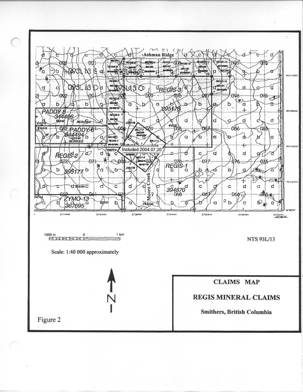
2 TABLE OF CONTENTS Page SUMMARY... INTRODUCTION... DISCLAIMER... LOCATION AND ACCESS... PHYSIOGRAPHY AND VEGETATION... CLAIMS AND OWNERSHIP... 2 PREVIOUS WORK... 2 GEOLOGY... 3 ADJACENT PROPERTIES... 3 PROSPECTING RESULTS... 3 GEOCHEMISTRY... 4 CONCLUSIONS AND RECOMMENDATIONS... 5 REFERENCES... 5 STATEMENT OF COSTS... 6 STATEMENT OF QUALIFICATIONS... 7 APPENDIX: Analyses. ILLUSTRATIONS: Location map; Figure following page Claims map; Figure 2....following page Grid locations; Figure 3... following page Geochemistry; Au and Ag, Grid, Figure 4a... Geochemistry; Cu and Mo, Grid. Figure 4b... Geochemistry; Pb and Zn. Grid. Figure 4c....following page Geochemistry; Au and Ag. Grid 2. Figure 5a... following page Geochemistry; Cu and Mo, Grid 2, Figure 5b... following page Geochemistry, Pb and Zn, Grid 2, Figure 5c... following page Grid ; numbered sample sites, Figure following page Grid 2; numbered sample sites, Figure 7... following page
3 SUMMARY Exploration on the Regis mineral claims in the Copper River area during 2004 comprised prospecting, grid preparation and soil sampling. This work was mainly directed to hrther the exploration of areas in which reconnaissance geochemical sampling had returned anomalous amounts of precious and base metals in soils overlying felsic volcanic rocks of the Hazelton Group. A copper occurrence was discovered on the southern slopes of the south end Ashman Ridge. Anomalous geochemical results were obtained for gold, silver and some base metals in a few localities. INTRODUCTION Regis Plante conducted a prospecting and geochemical program on the Regis and Regis 3 mineral claims in May and July, I was retained by him to offer suggestions and to review this work and to prepare an assessment report. I visited the property on 6 July this year and joined him in examining parts of the northern claims area. DISCLAIMER The prospecting and geochemical sampling were done by Regis Plante and an experienced crew, who also prepared the source maps. One of the crew members, Paul Charbonneau, has completed a prospecting course presented by Dr Tom Richards. Although I was not in the field when the geochemical samples were collected, I briefed the crew beforehand and later saw some of the soil sample sites. The work was apparently conducted in accordance with generally good exploration practice but I disclaim responsibility for the work. LOCATION AND ACCESS The centre of the Regis claims group is at approximately 54" 49' north latitude and 27" 5 ' west longitude, about 44 km west of Smithers, Omineca Mining Division, British Columbia, NTS Map 93L/3 or 93L.08 (Figure ). The McDonell Lake Forest Service Road provides good summer access to the claims. Winter road access is dependent upon logging activities. The road distance to the centre of the claims from Smithers is about 58 km. The claims are mostly free of snow from June until October. PHYSIOGRAPHY AND VEGETATION The claims cover part of the southern slopes of the southern end of Ashman Ridge and extend southward down to the Zymoetz (Copper) River. The claims area ranges in elevation from about 760 m on the ridge to 750 m near the river. Slopes are gentle to steep and there are local cliffs. The middle and lower slopes support stands of fir and hemlock trees. There are several logged areas on the lower claims. The claims are mostly in the Moore Creek drainage system, which drains into the Zymoetz River. Moore Creek and some of its tributaries run all year and can provide sufficient water for exploration and mining purposes. The outcrop distribution is highly variable on the claims. Outcrops are abundant along the top of Ashman Ridge, but they are generally rare on the lower slopes in the claims area.
4 I I I i - c) N N 0-0, 00, 200 KILOYTRCS XlLL. I : LOCATION MAP REGIS MINERAL CLAIMS Figure Smithers, British Columbia
5 4 CLAIMS AND OWNERSHIP The Regis property comprises 63 units in 5 mineral claims, as listed below. The expiry dates shown below reflect the application of the work outlined in this report. CLAIM UNITS TENURE EXPIRY Regis Regis 2 Regis 3 Regis 4 Regis 5 Regis 6 Regis 7 Regis 8 Regis 9 Regis 0 Regis Regis 2 Regis 3 Regis 4 Regis The recorded owner of the claims is Regis Plante, Box 2686, Station M, Calgary, Alberta, T2P 3C. PREVIOUS WORK Local small fracture fillings of copper minerals were found in felsic volcanic rocks within the area of the claims during logging road construction in the 990s. The showings were staked by Harold Thomas Hendrickson, under whose direction a flagged grid was prepared in the area of the showings. A VLF-EM survey was conducted over the grid and some short diamond drill holes were put down. The claims lapsed and the area was staked by Regis Plante in 200 (Willy -4) and 2002 (Regis -5). During the 2002 field season, Mr Plante drilled two short diamond drill holes in felsic volcanic rocks to test a VLF-EM anomaly. A conductive fault was intersected in one of the holes, but the test would have benefited from a longer hole. I confirmed part of the VLF- EM anomaly using a Phoenix VLF-2 electromagnetic receiver and I collected eleven reconnaissance silt and soil samples in the same general area, some of which carried anomalous amounts of lead (s 24 ppm) and zinc (5 552 pprn), or silver (I 3.6 ppm), copper ( 97 ppm) and molybdenum (r6 ppm). The geochemical analyses (aqua regia-icpaes) were performed by ALS Chemex of Vancouver, B.C.
6
7 -3- GEOLOGY The general area of the claims lies in the Stikine terrane of the Intermontane Belt, on the northern edge of the Skeena Arch and near the southern edge of the Bowser Basin. Much of the area is underlain by island arc volcanic and sedimentary rocks of the Hazelton Group (Jurassic), with basin-filling sandy and shaly rocks of the Bowser Lake (Jurassic) and Skeena (Cretaceous) groups to the north. In places, these rocks are cut by granitic intrusions of Late Cretaceous and Eocene age, some of which host mineral deposits with economic potential, and the area lies within a north-northwesterly trending belt of porphyry copper, molybdenum and other deposits that are associated with intrusions of Late Cretaceous or Tertiary age (Carter, 982). The geology has been mapped by Tipper (976) and the regional geological setting has been discussed by Tipper and Richards ( 976). All the confirmed outcrops discovered during prospecting on the claims to date are volcanic rocks assigned to the Lower Jurassic Telkwa Formation of the Hazelton Group. Most of these rocks are hematitic, subaerial, dacites or rhyolites. ADJACENT PROPERTIES The Paddy claims adjoin the Regis claims on the west. A widely-spaced soil geochemical program was conducted there in 997 and no significant anomalies were found (Chow, 998). The maximum results (aqua regia digestion/ ICP; Au by MIBK extraction and GFAA analysis) obtained in that survey for some selected elements follow: Au 30 ppb, Ag.8 ppm, Pb 47 ppm, Zn 248 ppm, Cu 56 ppm and Mo ppm. Other nearby prospects are the Zymo porphyry copper prospect, about 3 km west of the claims (Nelson, 2000); the Lefty showing, which is an apparently small copper occurrence in volcanic rocks a few hundred metres north of the claims (Minfile Number 093L 078); and the Louise Lake copper-gold porphyry system where there is an estimated resource of 50 million tonnes of 0.3% copper and 0.3 g/t gold and where work continued in 2004 (News release, Firestone Ventures Inc., 5 September 2004). The Louise Lake prospect is about km northeast of the Regis claims. PROSPECTING RESULTS Many outcrops of felsic volcanic rocks, including reddish hematitic tuffs, were observed during prospecting along the upper parts of the south slope of the southern end of Ashman Ridge. All these rocks are assigned to the Hazelton Group, and most are lacking in sulphide minerals of economic interest. However, a copper occurrence was discovered by Regis Plante at about 675m elevation in this area (figure 3) and the showing has been examined by me. The following NAD 83 UTM coordinates of the discovery were obtained using a Magellan SporTrak Map GPS receiver: E and N. Chalcopyrite and malachite occur here in a brecciated fault zone in a greyish red felsic volcanic host, poorly exposed in a small creek. The main malachite zone is approximately 5 cm in width. Also present are iron oxides, dendritic manganese oxides, calcite and an iron carbonate mineral in fracture fillings and disseminations. The mineralized fault may be controlled by a bedding plane and may strike about 290" and dip approximately 45' south. A few outcrops were found in the Grid area in the central claims, including several outcrops of a quartz-feldspar-porphyry tuff. These outcrops are shown on the geochemical survey Grid map (figure 4). Pyrite is rare in these rocks, but disseminated specular hematite was noted in several outcrops.
8 ~~~ ~ REGIS i > i Metres Metres c3z33er== -, I - > 3 GRID LOCATIONS Figure 3 REGIS MINERAL CLAIMS Map by Paul Charbonneau
9 -4- Small amounts of malachite, azurite, tetrahedrite, and relatively abundant iron and manganese oxides occur in a narrow fault zone in greyish red purple felsic tuff, accompanied by quartz and carbonate veinlets, in a road cut west of the upper Moore Creek bridge on the 7000 road. The fault zone trends 030" and dips at 85" to the southeast. The following NAD 83 UTM coordinates for this showing were obtained with a Garmin GPS 2 receiver: E and N, elevation040 m. This showing was drilled by Harold Hendrickson in the 990s with inconclusive results. GEOCHEMISTRY The soil sampling grids are shown on figures 3,4,5,6 and 7. Grid includes an enlargement of the Hendrickson grid which was established to control a VLF-EM survey and upon which a VLF-EM anomaly was discovered. Grid 2 was designed by Regis Plante to test a geochemical anomaly. Overburden is mostly till that varies in thickness from a few centimetres to many metres. One hundred and seventy-seven soil or silt samples were collected, of which 0 silt samples yielded insufficient sample material for analysis. Soil samples were recovered from Grid at intervals of 50 m or 00 m on flagged lines approximately 00 m or 200 m apart, depending upon grid sector. Soil samples were collected on Grid 2 at intervals of 50 m on flagged lines 00 m apart. Where possible, the samples were taken from the B soil horizon. The samples were retrieved with a shovel, placed in standard haft soil bags, air dried and were shipped by air to the ALS Chemex laboratory in North Vancouver, B.C. There the samples were analyzed for 34 elements using an aqua regia digestion and ICP-AES (code ME-ICP4; inductively coupled plasma-atomic emission spectroscopy) and tested for gold by fire assay-atomic absorbtion spectroscopy (code Au-AA23) using a 30 g nominal sample weight. The analytical results and field notes are in the Appendix. The geochemical thresholds were chosen in the 95'" percentile for each element and some comments on selected elements follow. GUM. The threshold for gold has been chosen at 0.02 ppm, above which there are eight anomalous samples ( pprn), the best of which were collected on Grid (Figure 4) Sher The silver threshold selected is ppm. There are anomalous results on lower Grid (52.6 ppm)and on the west side of Grid 2 (g.5 ppm). Cupper. With the anomaly threshold set at 50 ppm, there are only six modestly anomalous Cu samples (279 ppm). Molybdenum. Five samples exceed the threshold of 4 ppm. The strongest results came from scattered localities on Grid 2 (5 5 pprn). Lead. The threshold for lead is 27. Eight samples are anomalous and the strongest are spatially related to the Moore Creek drainage on Grid 2 (34 ppm). Zinc. There are eight anomalous zinc samples, using a threshold of 70 ppm. Most, and the strongest, are on the western half of Grid 2 (5246 ppm).
10 -5- CONCLUSIONS AND RECOMMENDATIONS, The Regis mineral claims cover an area generally underlain by felsic volcanic rocks of the Hazelton Group, including a quartz-rich tuff, in a belt with recognized economic potential. 2. Prospecting during 2004 resulted in the discovery of a copper occurrence in felsic, hematitic, volcanic rocks on the southern slope of Ashman Ridge. The occurrence is not of economic interest. 3. The geochemical surveys yielded some scattered anomalous results, the most interesting of which, especially for gold, are from silt samples on Grid. A silt sampling and detailed prospecting program in the Grid area should be completed before another soil sampling program is contemplated. Care must be taken to collect larger silt samples than in the first survey in order to ensure sufficient material for analysis, and the creeks and sample locations should be shown on a topographic map. 4. Silt samples should be collected elsewhere in the Moore Creek drainage system in the claims area, such that all silt-bearing tributaries are sampled. REFERENCES Carter, N.C., 982. Porphyry copper and molybdenum deposits, west-central British Columbia: B.C. Ministry of Energy, Mines and Petroleum Resources, Bulletin 64, 50 p. Chow, R., 998, Geochemical report on the Paddy claims: Report for Donegal Developments Ltd, 9 pages plus appendix. Assessment Report 25,557. Nelson, F.J., 2000, Zymo #7-7 claims, core drilling report: Report for Freeport Copper Company, 2 p. plus appendices. Assessment Report 26,52. Tipper, H.W., 976, Smithers map area, British Columbia: Geol. Survey of Canada, O.F. 35 Geological map). Tipper, H.W. and Richards, T.A., 976, Jurassic stratigraphy and history of north-central British Columbia: Geol. Survey of Canada, Bull. 270, 73 p.
11 -6- STATEMENT OF COSTS. Prospector's wages: Regis Plante,l6 $200/day $3, Paul Charbonneau,9 $200/day, FranCois Larocque, 7 $200/day, Michel Lachance, 8 $200/day, Consultant: A. L'Orsa, 2 $600/day, Report, Highland Helicopters: Bell 206B, % $,0O/hr Food and Accommodation:, Analyses:57 geochemical (3 $22.25/sample plus prep. 3,80.70 Shipping by Air Canada Truck rental: 6 days 2, TOTAL $9, ' di Anthony L'Orsa, P. Geo.
12 -7- STATEMENT OF QUALIFICATIONS I, Anthony T. L'Orsa of Smithers, British Columbia, hereby certifl that:. I am a geologist with business address at 8858 Adams Road, Smithers, B.C., VOJ 2N7 2. I am a graduate of Tulane University, New Orleans, Louisiana, U.S.A., with the degrees of Bachelor of Science (96) and Master of Science (964) in geology. 3. I have practised my profession in mineral exploration since 962 in western Canada, Australia and Mexico. 4. I am a fellow of the Geological Association of Canada, a member of the Society of Economic Geologists, a member of the Society for Geology Applied to Mineral Deposits, and a member of the Association of Professional Engineers and Geoscientists of the Province of British Columbia..&/%--+- Anthony L'Orsa, P.Geo. i
13 00s.,._ 'V s ' I s 9w 5w 4w LEGEND Figure 4a Sample site: Au, Ag in ppm. A Quartz-feldspar-porphyry tuff outcrop 0 Hematitic tuff outcrop. / ' El " 900m 3E 5E GRID GEOCHEMICAL RESULTS
14 .. 9w 7 w 5w 4w 5E LEGEND Figure 4b Sample site: Cu, Mo in ppm. A Quartz-feldspar-porphyry tuff outcrop. 0 Hematitic tuff outcrop. 0 Sandstone outcrop. Approx. creek location and direction. Thresholds: Cu 50 ppm; Mo 4 ppm. REGIS MINERAL CLAIMS GRID GEOCHEMICAL RESULTS COPPER AND MOLYBDENUM Base map by Paul Charbonneau, October 2004
15 N I ' 00s i 200s 300s 400s 500s 5E 600s LEGEND Figure 4c Sample site: Pb, Zn in ppm. A Quartz-feldspar-porphyry tuff outcrop. 0 Hematitic tuff outcrop. 0 Sandstone outcrop. Y Approx. creek location and direction. a, 8 ' E 0 74 n47n REGIS MINERAL CLAIMS GRID GEOCHEMICAL RESULTS LEAD ANDZINC Base map by Paul Charbonneau, October 2004
16 4 N - - A <,< cp.3 o.&, t <)a2 i 22m6 I - <,L.S - - <,D.L~. <,0.3 ~~0.3 o.om,o$ A \ c:< 2300 s - - <'L q0.2 q $. - < 0,q ) - LEGEND Sample site: Au, Ag in ppm. $ 2 < Below detection limits. -- Approx. creek location and direction. Thresholds: Au 0.02 ppm; Ag ppm. Samples ~0.005 ppm Au and 0.2 Ag not shown. kl%i Metres 0 " 8 0 REGIS MINERAL CLAIMS GRID 2 GEOCHEMICAL RESULTS GOLD AND SILVER Figure 5a Base map by Paul Charbonneau, October 2004 I
17 N 200 s z2a 6 \ \ 5: I 2300 s LEGEND Sample site: Cu, Mo in ppm. k Approx. creek location and direction. Thresholds: Cu 50 ppm; Mo 4 ppm. Metres Figure 5b REGIS MINERAL CLAIMS GRID 2 GEOCHEMICAL RESULTS COPPER AND MOLYBDENUM Base map by Paul Charbonneau, October 2004
18 N I '&,%a- I o, 0 ~ -74 J - LEGEND Sample site: Pb, Zn in ppm. > Approx. creek location and direction. Thresholds: Pb 27 ppm; Zn 70 ppm. 0 ". "! a Metres O m - REGIS MINERAL CLAIMS I GRID 2 GEOCHEMICAL RESULTS LEAD AND ZINC I
19 ~ 745g\:i 6VJ tic :3s 5E 4 3 LEGEND 0 Sample site. +, Silt sample..-&, ; Samples 89 to 97 belong to corrected 4s line. REGIS MINERAL CLAIMS. Figure6 GRID SAMPLE SITES Map by Paul Charbomeau, October 200
20 4 N I Figure 7 REGIS MINERAL CLAIMS O b " < 0 GRID2 SAMPLE SITES Map by Paul Charbonneau, October 2004
21 APPENDIX

22 I

23
NEW HAZELTON, OMINECA M.D.,
 PROSPECTING REPORT JUDI 1 TO 6 MINERAL CLAIMS NEW HAZELTON, OMINECA M.D., B.C. MAP 93M/4E, LAT. SS014'N, LONG. 127'33'W OWNED BY: A. L'ORSA ANTHONY L'ORSA Smithers, B.C. 21 February, 1981 TABLE OF CONTENTS
PRECIOUS METALS. owner. JMT Services Corp. GEOCHPlICAL SAMPLING CHELASLIE WCE, NORTH CENTRAL, B.C. OMINECA MINING DIVISION NTS 93F/5E & 6W
 PRECIOUS METALS REPORT ON 1980 RECONNAISSANCE GEOCHPlICAL SAMPLING CHELASLIE WCE, NORTH CENTRAL, B.C. OMINECA MINING DIVISION NTS 93F/5E & 6W LATITUDE 53O28 N LONGITUDE 125O31 W DATES Qp WORK: JULY 10
NTS 93L/9W GEOCHEMICAL AND GEOPHYSICAL REPORT MONA CLAIM OMINICA MINING DIVISION. Lati tude 54036'N; Longitude 'W
 GEOCHEMICAL AND GEOPHYSICAL REPORT ON MONA CLAIM OMINICA MINING DIVISION Lati tude 54036'N; Longitude 126018'W NTS 93L/9W April 1981 Paul Plicka Consulting Geologist LOCATION MAP INTRODUCTION TABLE OF
ASSESSMENT REPORT. Geochemical and Geological Surveys. on the. Gooch#1-4. Mineral Claims. Omenica Mining District NTS 93L/7W
 f- GEOLOGICAL BRANCH ASSESSMENT REPORT ASSESSMENT REPORT Geochemical and Geological Surveys on the Gooch#1-4 Mineral Claims Omenica Mining District NTS 93L/7W LAT: 54O25'W LONG: 126O26'W Operator: SMD
W. 1.NELSON Jr. P. ENG.
 GEOCHEMICAL AND GEOPHYSICAL SURVEY SNO GROUP CLAIMS W. 1.NELSON Jr. P. ENG. NORANDA EXPLORATION COMPANY, LIMITED OMINECA MINING DIVISION AUG. 17, 1971 - AUG. 29, 1971 TABLE OF CONTENTS - Page INTRODUCTION
for the Greenwood Mining Division, B.C. NTS 82E/7W Latitude 49' 27' W, Longitude 118' 5 Prepared by a= D. Dylan Watt, B.Sc.
 t. b LOGnO: 37~ -08 m. ACTIO#: for the AMP AMP 2 AMP 3 t AMP 4 CLAIMS Greenwood Mining Division, B.C. NTS 82E/7W Latitude 49' 27' W, Longitude 8' 5 %E c,w zc *& a w Prepared by a= -4c. D. Dylan Watt, B.Sc.
UNION MINIERE EXPLORATIONS AND MINING CORPORATION LIMITED ASSESSMENT REPORT ON FITINAT MINERAL CLAIM. Alberni Mining Division Record No.
 M F )( UNION MINIERE EXPLORATIONS AND MINING CORPORATION LIMITED Suite 200, 4299 Canada Way, Burnaby, B.C. V5G 1 H4 Telephone (604) 437-9491 ASSESSMENT REPORT ON GEOCHEMICAL SOIL SURVEYS AND ROCKSAMPLING
RECONNAISSANCE GEOCHEMICAL SURVEY
 RECONNAISSANCE GEOCHEMICAL SURVEY LEGAL, RITA, LOUISE FR. (CHAPLEAU GROUP) REVERTED CROWN GRANTS CHAPLEAU CREEK AREAJ, SLOC& MINING DIVISION 82 F/11W Lat: 49'44" Long: 117"22'W MINERAL RESOURCES BRANCH
lat ' N Long ' W
 305 7 ec1;, REPORT ON THE JERY CLAIMS OF POLA RESOURCES LTD. NTS 93L/16 0 0 lat. 54 45' N Long. 126 22' W BABIXE LAKE AREA OMINECA MINING DIVISION, B.C. PAUL PLICKA CONSULTING GEOLOGIST DECEMBER 30, 1981
PHYSICAL WORK REPORT. the BAY CLAIMS. Omineca Mining Division Smithers, British Columbia N.T.S. 93E 13E/W
 PHYSICAL WORK REPORT the BAY CLAIMS Omineca Mining Division Smithers, British Columbia a N.T.S. 93E 13E/W LATITUDE: 53 57 00 N I LONGITUDE: 127 45 OO W for Home Ventures Ltd. 1201-675 West Hastings Street
SECOND and THIRD YEAR ASSESSMENT REPORT PROSPECTING LICENCE M, ROCK CUT PROPERTY, NTS 1N/12, NEWFOUNDLAND. ROY FRENCH (licence holder )
") SECOND and THIRD YEAR ASSESSMENT REPORT Of PROSPECTING On LICENCE 013704M, ROCK CUT PROPERTY, NTS 1N/12, NEWFOUNDLAND. By ROY FRENCH (licence holder ) Work Conducted: Sept. 17, 2008 Nov. 03, 2009 Total
SECOND and THIRD YEAR ASSESSMENT REPORT Of PROSPECTING On LICENCE 013704M, ROCK CUT PROPERTY, NTS 1N/12, NEWFOUNDLAND. By ROY FRENCH (licence holder ) Work Conducted: Sept. 17, 2008 Nov. 03, 2009 Total
PROSPECTORS ASSISTANCE PROGRAM MINISTRY OF ENERGY AND MINES
 BRITISH COLUMBIA PROSPECTORS ASSISTANCE PROGRAM MINISTRY OF ENERGY AND MINES GEOLOGICAL SURVEY BRANCH PROGRAM YEAR: 1999/2000 REPORT #: PAP 99-l 6 NAME: KIM ANSCHETZ PROSPECTORS TlEPORT on the 99 LOUIS
CONTENTS. Location, Access and History...6. Tenure Status and Geology Regional Andy Property Geology Map...9
 TYPE OFWORK IN THIS REPORT EXTENT OF WORK (rn METRTC UNITS) ON WHICH CLAIMS PROJECT COSTS APPORTIONED (incl. support) GEOLOGICAL (scale, area) Ground, mapping Photo interpretation GEOPHYSICAL (line-kilometres)
BALFOUR MINING LTD. (N.P.L.) HAM GROUP 92-P-6, CLINTON M. D.8 B. C. Lat 51 17'N, GEOCHEMICAL REPORT. V. CUKOR, P. Eng.
 HAM GROUP 92-P-6, CLINTON M. D.8 B. C. Lat 51 17'N, GEOCHEMICAL REPORT. V. CUKOR, P. Eng.") 34q '7 BALFOUR MINING LTD. (N.P.L.) HAM GROUP 92-P-6, CLINTON M. D.8 B. C. Lat 51 17'N, Long 12lo14'W GEOCHEMICAL REPORT, V. CUKOR, P. Eng. January 31, 1972 TABLE OF CONTENTS 1. INTRODUCTION 2. PROPERTY,
34q '7 BALFOUR MINING LTD. (N.P.L.) HAM GROUP 92-P-6, CLINTON M. D.8 B. C. Lat 51 17'N, Long 12lo14'W GEOCHEMICAL REPORT, V. CUKOR, P. Eng. January 31, 1972 TABLE OF CONTENTS 1. INTRODUCTION 2. PROPERTY,
for the Greenwood Mining Division, B.C. NTS 82E/7W 29' W, Longitude 118' 53' N Prepared by D. Dylan Watt, B.Sc.
 for the FltE NO: u VOLT 1, VOLT 2, VOLT 3, & VOLT 4 CLAIMS Greenwood Mining Division, B.C. NTS 82E/7W Latitude 49' 29' W, Longitude 118' 53' N Prepared by D. Dylan Watt, B.Sc. #309-1996 Trutch Street Vancouver,
2013 GEOLOGICAL ASSESSMENT REPORT SHERIDAN HILL PROPERTY
 2013 GEOLOGICAL ASSESSMENT REPORT ON THE SHERIDAN HILL PROPERTY NEW WESTMINSTER MINING DIVISION BRITISH COLUMBIA NTS 092G07 49 16 31 NORTH LATITUDE, 122 39 48 WEST LONGITUDE PREPARED FOR Sheridan Hill
Lat. 52' 43' N Long ' W
 &A exploration ltd MINING ENGINEERING GEOLOGY- GEOPHYSICS 4570 HOSKINS ROAD, NORTH VANCOUVER, 6. C. TELEPHONE (804) 985,7921 V7K 2R1 GEOLOGICAL AND GEOCHEMICAL REPORT on the BLUE CLAIMS Cariboo Mining
vox 1wo LOG NO: SEP 1 019% RD. &CTlON. JG-1, PILOT GOLD, PILOT GOLD 1 h 2. AND GOLD WING 1 TO 6 CLAIMS for HAROLD ADAMS Box 1329 Princeton, B.C.
 LOG NO: SEP 1 019% RD. &CTlON. JG-1, PLOT GOLD, PLOT GOLD 1 h 2. AND GOLD WNG 1 TO 6 CLAMS r Weyrnan Creek Area Kamloops Mining Division 82L-5W (50O22' N. Lat., 119O59' W. Long.) for HAROLD ADAMS Box 1329
Serengeti Resources Inc GEOCHEMICAL REPORT ON THE SHADOW PROPERTY a.
 Serengeti Resources Inc. 2004 GEOCHEMICAL REPORT ON THE SHADOW PROPERTY a. Located in the Johanson Lake Area Omenica Mining Division NTS 94D/9 6 degrees and 32 minutes North Latitude 126 degrees and 2
REPORT. on the. Omineca Mining Division, British Columbia. Latitude N., Longitude W. NTS map sheet 93F/7E. James W. McLeod, P.Geo.
 REPORT on the CHU MOLYBDENUM PROPERTY Omineca Mining Division, British Columbia Latitude 53 21 N., Longitude 124 37 W. NTS map sheet 93F/7E James W. McLeod, P.Geo. on behalf of Mr. Chris Delorme TABLE
The Cobalt Rainbow. Airborne geophysical maps show that a north trending aeromagnetic high suggests further undiscovered mineralisation.
 The Cobalt Rainbow The property is located on Greenstone Creek, approximately 4.8 kilometres south west of the creek mouth. The property is located about 24 km due west of Campbell River, in the east-central
TERA 1-4; reccrd no s Clifford McNeill TENA 5-10; record no s Owner: lrnest G. Olfert
 GEOCHENIC-:-I, SURVEY REPORT ON MINXAL CLAIMS TERA 1-4; reccrd no s 9107-9110 Owner: Clifford McNeill TENA 5-10; record no s 9399-9404 Owner: lrnest G. Olfert Located in the Orineca Mining Division of
Goliath Reports Grams Per Tonne Gold Equivalent Over 2 Metres Channel Cut at Golddigger in the Golden Triangle; Bulk Sample Recommended
 Goliath Reports 22.83 Grams Per Tonne Gold Equivalent Over 2 Metres Channel Cut at Golddigger in the Golden Triangle; Bulk Sample Recommended November 28, 2017 Goliath Resources Ltd. (TSX-V: GOT) (the
GEOLOGICAL MAPPING REPORT ON THE ASH MINERAL CLAIM OSOYOOS MINING DIVISION ASHNOLA RIVER MAP SHEET NTS M092,H019 MCBRIDE CREEK AREA, ASHNOLA RIVER,
 GEOLOGICAL MAPPING REPORT ON THE ASH MINERAL CLAIM OSOYOOS MINING DIVISION ASHNOLA RIVER MAP SHEET NTS M092,H019 LATITUDE 49 o O6, LONGITUDE 120 o 22 MCBRIDE CREEK AREA, ASHNOLA RIVER, KEREMEOS, B.C. CANADA
GEOLOGIC SETTING OF THE WADSWORTH VEIN: AN INTRUSIVE-RELATED GOLD DISCOVERY NEAR TERRACE, B.C.
 WADSWORTH VEIN By Paul J. Wojdak, Wayne Bulmer and Daryl J. Hanson LOCATION: Lat. 54 57 33 N Long. 128 50 09 W (103I/15W) CLAIMS: ACCESS: SKEENA MINING DIVISION. The property is located in the Cedar River
Prospecting Report 'S Office i DB Property, B.C. -J Negro Creek Nelson Mining District NTS 82F.050. Operator: Kootenay Gold Inc.
 . '.' I"' i9 12 Prospecting Report 'S Office i DB Property, B.C. -J Negro Creek Nelson Mining District NTS 82F.050 Operator: Kootenay Gold Inc. Owner: Darlene Lavoie Work Performed Summer of 2007 Report
ON THE LOST GOLD PROPERTY
 ON THE LOST GOLD PROPERTY NELSON MINING DIVISION BRITISH COLUMBIA Latitude: 49 18 North Longitude: 117 29.West TRIM MAPS: 82F1023,033 NTS: 8tF/5,6 By: Fred Critchlow . TABLE OF CONTENTS r PAGE lutroduction
ASSESSMENT REPORT ON THE PEAVINE PROJECT. DGW & Associates # Alberni Street, Vancouver, British Columbia, V6E 4V2
 ASSESSMENT REPORT ON THE PEAVINE PROJECT KAMLOOPS MINING DIVISION BRITISH COLUMBIA NTS 082M 12 Latitude 51 36' 19.0"North -- Longitude --119 47' 27.0"West UTM Zone 11, NAD 83 5720827N 306744E Prepared
Mineral Claims. Aspen Grove Area Nicola Mining Division, British Columbia. Latitude N., Longitude W. NTS Map Sheet 92H/lSE
 Mineral Claims Aspen Grove Area Nicola Mining Division, British Columbia Latitude 49 51 N., Longitude 120 35 W. NTS Map Sheet 92H/lSE James P. Balmer, B.SC., P.Geo. on behalf of Gary Brown November 26,2003
CARIBOO - GRIZZLY ZINC PROJECT
 CARIBOO - GRIZZLY ZINC PROJECT The Grizzly Lake or Cariboo Zinc property straddles the gravel Weldwood 8400 logging road in the Grizzly Lake area about 55 kilometres northeast of Likely. Roads constructed
ANTLER GOLD EXPLORATION UPDATE, WILDING LAKE GOLD PROJECT, NEWFOUNDLAND
 ANTLER GOLD EXPLORATION UPDATE, WILDING LAKE GOLD PROJECT, NEWFOUNDLAND HALIFAX, NOVA SCOTIA (CNW May 10, 2018) Antler Gold Inc. ( Antler ) (TSX-V:ANTL) is pleased to provide an update on its upcoming
REPORT SOIL GEOCHEMICAL SURVEY. ATTYCELLEY NO. 2 GROUP (Attycelley Mineral Claims No. 7-10)
") REPORT SOIL GEOCHEMICAL SURVEY ATTYCELLEY NO. 2 GROUP (Attycelley Mineral Claims No. 7-10) Situated 7 miles east of north end of Thutade Lake, Omineca Mining Division British Columbia I Department of I
REPORT SOIL GEOCHEMICAL SURVEY ATTYCELLEY NO. 2 GROUP (Attycelley Mineral Claims No. 7-10) Situated 7 miles east of north end of Thutade Lake, Omineca Mining Division British Columbia I Department of I
DSM SYNDICATE DISCOVERS POLYMETALLIC MINERALIZATION WITH TALUS GRAB SAMPLES CONTAINING UP TO PERCENT LEAD AND 18
 DSM SYNDICATE DISCOVERS POLYMETALLIC MINERALIZATION WITH TALUS GRAB SAMPLES CONTAINING UP TO 92.8 GRAMS PER TONNE GOLD, 13,643 GRAMS PER TONNE SILVER, 13.85 PERCENT LEAD AND 18.65 PERCENT COPPER FROM DIFFERENT
490 20' 30" North Latitude ' 30" West Longitude
 _._.. I CONSULTING GEOLOGISTS 605-602 WEST HASTINGS STREET, VANCOUVER, B.C. V6B 1P2 TELEPHONE: (604) 689-5533 6 I F: ASSESSMENT REPORT ON THE PATSY 1 MINERAL CLAIM ' '?%2% I WHISTLE CREEK, HEDLEY ARE L-l-
MtNERAL EXPLORATION CONSULTANTS ASSESSMENT REPORT MT. MILLIGAN AREA OMINECA M.D. Latitude: 55' 07' N Longitude: 123" 56' W NTS : 93 0/4 W.
 D. L. COOKE AND ASSOCIATES LTD. MtNERAL EXPLORATION CONSULTANTS ASSESSMENT REPORT 1989 PRELIMINARY GEOCHEMICAL SURVEY KC MINERAL CLAIMS MT. MILLIGAN AREA OMINECA M.D. Latitude: 55' 07' N Longitude: 123"
VANCOUVER, B.C. Tri 082F/ F/059
 GEOCHEMCAL REPORT t MAY L, 2006 Whbpper Mineral Claims Ailsa Lake Area Gold comm~ss16fl8f"s Offim on Mining Division VANCOUVER, B.C. Tri 082F/058 082F/059 3792 E 5486438 N Operator Kootenay Gold nc. Suite
GEOPHYSICAL REPORT INDUCED POLARIZATION/RESISTMTY SURVEYS. on behalf of TEESHIN REOURCES LTD Argus Road. Oakville, Ontario L6J 354
 GEOPHYSICAL REPORT INDUCED POLARIZATION/RESISTMTY SURVEYS DOME MOUNTAIN PROPERTY, SMITHERS AREA CHRIS, APRIL 1, APRIL 2, APRIL 3, AND MAG 1 CLAIMS CMINECA MINING DMSION, BRITISH COLUMBIA Latitude: 546
ASSESSMENT REPORT GEOLOGICAL BRANCH. 50' 23 'North. GEOLOGICAL and GEOCHEMICAL SURVEYS ON THE. PUTNAM PROPERTY (Putnam Mineral Claim)
") GEOLOGICAL and GEOCHEMICAL SURVEYS ON THE PUTNAM PROPERTY (Putnam Mineral Claim) VERNON MINING DIVISION, B.C. GEOLOGICAL BRANCH ASSESSMENT REPORT NTS : Latitude: 82L17W 50' 23 'North LOCATION, ACCESS,
GEOLOGICAL and GEOCHEMICAL SURVEYS ON THE PUTNAM PROPERTY (Putnam Mineral Claim) VERNON MINING DIVISION, B.C. GEOLOGICAL BRANCH ASSESSMENT REPORT NTS : Latitude: 82L17W 50' 23 'North LOCATION, ACCESS,
May 17, Two holes explored the extension at depth of the historic Sta Rosa vein
 May 17, 2011 PROSPERO INTERSECTS 781 g/t Ag, 1.2% Cu, 4.1% Zn OVER 2.62 METERS; DISCOVERS NEW ZINC RICH CANAL ZONE AT SAN LUIS DEL CORDERO PROJECT, MEXICO Vancouver, B.C. - Prospero Silver Corp. (TSX VENTURE:
REPORT ON DIAMOND DRILLING SUBSTITUTION EAST PROPERTY CLAIMS AND HEBERT TOWNSHIP ONTARIO, CANADA
 REPORT ON DIAMOND DRILLING SUBSTITUTION EAST PROPERTY CLAIMS 1248920 AND 1248921 HEBERT TOWNSHIP ONTARIO, CANADA Adroit Resources Inc. Suite #610-1111 Melville Street Vancouver, British Columbia, Canada
For personal use only
 ANNOUNCEMENT TO THE AUSTRALIAN SECURITIES EXCHANGE: 28 NOVEMBER 2012 DRILLING UPDATE MABILO PROJECT The Directors of Sierra Mining Limited ( Sierra ) are pleased to announce further results from reconnaissance
NTS 082F03SW N W U E N
 Prospecting Report JOCELYN CLAIM NTS 082F03SW N49 09 51 W 117 14 04 11U 482906E 5445737N NELSON MINING DIVISION Martin Ross PO Box 323 Salmo BC V0G 1Z0 Jan 31, 2012 PROSPECTING REPORT JOCELYN MINERAL CLAIM
News Release No GOLD AND COPPER MINERALIZATION DISCOVERED DURING PHASE 2 EXPLORATION AT THE MCBRIDE PROPERTY
 November 19, 2018 TSX Venture Exchange Listed Frankfurt Exchange Listed News Release No. 303-2018 GOLD AND COPPER MINERALIZATION DISCOVERED DURING PHASE 2 EXPLORATION AT THE MCBRIDE PROPERTY Vancouver,
PROSPECTING REPORT THE WALLACE CLAIM OMENICA MINING DIVISION. 54" x6" 3.d d. for. Reako Exlorat ions Ltd. Wallace Rev. C.G.
 PROSPECTING REPORT ON THE WALLACE CLAIM OMENICA MINING DIVISION 54"44 14 1x6" 3.d d by David A. Howard P.Eng. for Reako Exlorat ions Ltd. Claim Locat ion Wallace Rev. C.G. #1560 Dome Mountain Area 9 3
Structural Analysis Using Hillshade Imagery. on the. LLC Property
 Structural Analysis Using Hillshade Imagery on the LLC Property Liard Mining Division NTS 104F/16W Latitude: 57 53' 47'' N Longitude: 132 03' 06'' W Owner Garry John Payie 3714 Raymond Street South, Victoria,
R.A. COMINCO LTD. EXPLORATION NTS: 92H/16. WESTERN DISTRICT January 6, 1982 ASSESSMENT REPORT 1981 SOIL GEOCHEMISTRY ON THE TROUT PROPERTY
 COMINCO LTD. EXPLORATION NTS: 92H/16 WESTERN DISTRICT January 6, 1982 ASSESSMENT REPORT 1981 SOIL GEOCHEMISTRY ON THE TROUT PROPERTY (Trout 1 and 6 Claims) SIWASH LAKE AREA, SIMILKAMEEN M.D., B.C. (Work
FIRST YEAR ASSESSMENT REPORT PROSPECTING LICENCE 16512M MARYSTOWN AREA, BURIN PENINSULA NTS 1M/3
 FIRST YEAR ASSESSMENT REPORT OF PROSPECTING ON LICENCE 16512M MARYSTOWN AREA, BURIN PENINSULA NTS 1M/3 BY NATHANIEL NOEL MSc. FOR E. MICHELE NOEL MINERAL LICENCES: 16512 M WORK CONDUCTED: MID-SEPTEMBER
Drilling Program Commences on Iron Oxide Copper Gold Targets
 3 June 2008 Manager Company Announcements Company Announcements Office Australian Stock Exchange Limited Level 10, 20 Bond Street SYDNEY NSW 2000 ABN 42 082 593 235 Electronic delivery No of pages: 6 Drilling
12 tons of high-grade ore was mined from the No. 1 vein with an average grade of 13 g/t gold, 3,250 g/t silver and 23.3% lead.
 DUNWELL MINE GROUP The Dunwell Mine Group (Dunwell, Dunwell East, Bear River/MM and Silvershot properties), which includes the historic, past-producing Dunwell mine, is located 8 km northeast of Stewart
HDN MINERAL PRO iperty
 HDN MINERAL PRO iperty ROCK SAMPLE GEOCHEMISTRY ASSESSMENT REPORT 2010 OMINECA MINING DIVISION, BRITISH COLUMBIA 93L047 LATITUDE: 54 29' 16.9" N LONGITUDE: 126 39' 39.8" W GPS: NAD 83 UTM ZONE 9 NORTHING:
Geochemical Assessment Report. on the. Situated Nineteen Kilometres rth-northeast of Hope, B. C. in the. New Westminster Mining Division
 7 I Geochemical Assessment Report r on the r- I 1 Norm 1 to Norm 4 Mineral Claims c - I - 7 Situated Nineteen Kilometres rth-northeast of Hope, B. C. in the New Westminster Mining Division itude 49*32'N.,
49" 3-4 I4 I \ Y 59 tj
 ASSESSMENT REPORT Mary 4 FORT STEELE M.D. NTS 82G/5W 49" 3-4 4 \ Y 59 tj Owner: St. Eugene Mining Corporation Limited Operator : St. Eugene Mining Corporation Limited Author: John R. Wilson Date Submitted:
ISKUT RIVER - TELEGRAPH CREEK: NEW EXPLORATION OPPORTUNITIES IN THE BC REGIONAL GEOCHEMICAL DATABASE
 ISKUT RIVER - TELEGRAPH CREEK: NEW EXPLORATION OPPORTUNITIES IN THE BC REGIONAL GEOCHEMICAL DATABASE By Ray Lett 1 and Wayne Jackaman 2 KEYWORDS: Regional stream sediment surveys, archival samples, gold,
Jedway Enterprises Ltd st Ave, Surrey, BC V3S 3M3
 Jedway Enterprises Ltd. 104-19286 21 st Ave, Surrey, BC V3S 3M3 Prospecting Report on the Den (Den#1 to #4) Property, Takla Landing Area, Omineca Mining Division, British Columbia NTS 93N/12 Trim 093N052,093N062
ASSESSMENT REPORT TITLE PAGE AND SUMMARY
 ASSESSMENT REPORT TITLE PAGE AND SUMMARY TITLE OF REPORT: Assessment Report on Andys Bridge Mineral Claim, Turnagain River Area TOTAL COST: $2,100 AUTHOR(S): Bruce w Downing SIGNATURE(S): Bruce W Downing
BLURTON CREEK NICKEL PROPERTY. (Minfile # 082LNW-039)
") 5489153 BLURTON CREEK NICKEL PROPERTY (Minfile # 082LNW-039) Mara Lake Area / Salmon Arm B.C NTS - 82L-11 (UTM 83/Z10, 357690E, 5614220N) Prepared by: Jim Cuttle, B.Sc., P.Geo. 86 Cloudburst Road Whistler,
5489153 BLURTON CREEK NICKEL PROPERTY (Minfile # 082LNW-039) Mara Lake Area / Salmon Arm B.C NTS - 82L-11 (UTM 83/Z10, 357690E, 5614220N) Prepared by: Jim Cuttle, B.Sc., P.Geo. 86 Cloudburst Road Whistler,
TABLE OF CONTENTS APPENDICES SUMMARY DRILL LOG STATEMENT OF QUALIFICATION STATEMENT OF EXPENDITURES LIST OF FIGURES
 ASSESSMENT WORK REPORT DIAMOND DRILLING PROGRAM AUGUST AND SEPTEMBER, 1980 ON CLAIMS Molly Tom 1-4 and 8 Omineca Mining Division NTS 93M/llU 55'35'N, 127"29'W by David A. Bending Owner: Operator: Texasgulf
Burchell Lake, A Copper, Gold and Molybdenum Property In Ontario. Corporate Presentation September, 2013
 Burchell Lake, A Copper, Gold and Molybdenum Property In Ontario Corporate Presentation September, 2013 Background Tanager Energy Inc. is a Canadian corporation whose shares are traded on the TSX Venture
MEMORANDUM. Interpretation of Magnetic and Volterra-3DIP survey MC Claims
 11966 95A Avenue, Delta, BC V4C 3W2 Canada Tel +1 (604) 582-1100 www.sjgeophysics.com MEMORANDUM Date: September 13, 2017 From: To: SUBJECT: E. Trent Pezzot Bonanza Mining Corporation Interpretation of
The McPhillamys Gold Deposit, Discovery History & Geology. Presenter: Tara French
 The McPhillamys Gold Deposit, Discovery History & Geology. Presenter: Tara French Forward-Looking Statements This presentation contains forward-looking statements. without limitation: Estimates of future
GEOPHYSICAL REPORT CHU CHUA PROJECT Green Mountain Group. KAMLOOPS MINING DIVISION NTS 92P/8E, 82M/5W Lat: 51'24' N Long: 120'00' w
 I GEOPHYSICAL REPORT CHU CHUA PROJECT Green Mountain Group KAMLOOPS MINING DIVISION NTS 92P/8E, 82M/5W Lat: 51'24' N Long: 120'00' w I rvm #.,_..._..._._._.- $...-...! 1 VANCOUVER, B.C. 1 G E 0 I, 0.G
Narrow High-Grade Gold and Long Low-Grade Porphyry Gold and Copper-Gold Intercepts at Bulago
 CONTACTS PHONE EMAIL PO Box 52 +61 (08) 9295 0388 info@frontierresources.com.au West Perth FAX WEBSITE WA 6872 Australia +61 (08) 9295 3480 www.frontierresources.com.au ASX Limited Company Announcements
MINAURUM GOLD INC : : News Releases
 MINAURUM GOLD INC : http://www.minaurum.com/ : News Releases November 26, 2018 Minaurum Samples 102 g/t Gold and 4.6% Copper at Newly Discovered Alessandra Vein Minaurum Gold, Inc., ("Minaurum") is pleased
sq N & %%.& GEOPHYSICAL CONSULTING rr SERVICES LTD. $%& Long. 118o3OtW N.T.S. 82 E/15 -I- AUTROR: Glen E. Whi*e, B.Sc., P. %g.
 -\ GEOCHEMICAL EXPORT.,~.,~..'.. AMORE MINERALS 1NCORPOR;ITZC,' ~. 3rd fl5 Geo 3. and 2 mineral claims, Vernon- ~ $lining Division, B. C. Lat. 49 47'T?,,/ Long. 118o3OtW N.T.S. 82 E/15 -I- AUTROR: Glen
ANTLER GOLD DRILLS GRAMS PER TONNE GOLD OVER 5.35 METRES AT THE WILDING LAKE GOLD PROJECT, NEWFOUNDLAND
 ANTLER GOLD DRILLS 10.01 GRAMS PER TONNE GOLD OVER 5.35 METRES AT THE WILDING LAKE GOLD PROJECT, NEWFOUNDLAND HALIFAX, NOVA SCOTIA (CNW December 13 th, 2017) Antler Gold Inc. ( Antler ) (TSX- V:ANTL) is
GEOCHEMICAL AND PROSPECTING REPORT. RC ly 2,3,4 CLAIMS
 p- ON GEOLOGlCAL SURVEY BRANCH ASSESSMENT REPORTS - DATE RECFl'dFD AFR 0 1 19% GEOCHEMICAL AND PROSPECTING REPORT THE RC ly 2,3,4 CLAIMS IARD MINING DIVISION BRIT1 S H COLUMBIA 94E/EI W LATITUDE 57" 48'
n3a 92 C- /.I 4 tr November 6, 1979 J. F. MclNTYRE, P.ENG. CONSU LTlNG MINING ENGl NEER Map #92C-16 TRANS PACIFIC VENTURES LTD.
 TELEPHONE : 5 9 6-1331 J. F. MclNTYRE, P.ENG. CONSU LTlNG MINING ENGl NEER 6466 CAGELDU CRESCENT DELTA, B.C. CANADA TRANS PACIFIC VENTURES LTD. c i. SAMPLING AND GEOPHYSICAL REPORT CAP CLAIM, VICTORIA
DISCOVERY OF MINERALISED PORPHYRY & MAGNETITE-COPPER-GOLD AT KAMARANGAN
 MEDUSA MINING LIMITED ABN: 60 099 377 849 Unit 7, 11 Preston Street Como WA 6152 PO Box 860 Canning Bridge WA 6153 Telephone: +618-9367 0601 Facsimile: +618-9367 0602 Email: admin@medusamining.com.au Internet:
GRANGES EXPLORATION AB CANADIAN DIVISION
 GRANGES EXPLORATON AB CANADAN DVSON GEOCHEMCAL REPORT ON "B" and "D" CLAMS OMNECA MNNG DEVSON FAWNE NOSE AREA LATTUDE: 53O 19' LONGTUDE: 125O 1' MNERAL RESOURCES BRANCH N.T.S 93F/6 E Owner and Operator
GEOLOGICAL BRANCH ASSESSMENT REPORT 12. FItE NO: ACTION: THE GOLDEN MINING DIVISION, GOLDEN, Including THE NTS MAP; M82K/15W
 ACTION: FItE NO: Including 1990 GEO-CHEM SURVEY RESULTS -- THE AVD CLAIMS - THE GOLDEN MINING DIVISION, GOLDEN, B.C. NTS MAP; M82K/15W Lat. 50 deg. 55 Min. Long 116 deg. 55 min. For GEOLOGICAL BRANCH ASSESSMENT
M.R.# _..._ $._. ' VANCOUVER, R.C
 COMINCO LTD. EXPLORATION NTS: 0G/ WESTERN CANADA 0 November ASSESSEMENT REPORT GEOCHEMICAL SURVEY ON THE SADDLEHORN PROPERTY LIARD MINING DIVISION BRITISH COLUMBIA M.R.# _....._ $._. ' VANCOUVER, R.C I
twd$ yqsi+hca
 -t@~cl--t,i twd$ yqsi+hca C ASSESSMENT REPORT ON THE OR0 1-5 CLAIMS NEAR GOLDBRIDGE, B.C. Lillooet Mining Division N.T.S. 92 J / 15 W Long. 122 51.5 W. Lat. 50 47.5 N. Owned by Levon Resources Ltd. Optioned
BALTO RESOURCES LTD. (Owner & Operator) GEOPHYSICAL ASSESSMENT REPORT. (Event Number ) on the SED MINERAL CLAIM.
 GEOPHYSICAL ASSESSMENT REPORT. (Event Number ) on the SED MINERAL CLAIM.") BALTO RESOURCES LTD. (Owner & Operator) GEOPHYSICAL ASSESSMENT REPORT (Event Number 5173274) on the SED MINERAL CLAIM (Tenure 392163) Kamloops Mining Division NTS 092I.047 Centre of Work 5589550N, 667600E
BALTO RESOURCES LTD. (Owner & Operator) GEOPHYSICAL ASSESSMENT REPORT (Event Number 5173274) on the SED MINERAL CLAIM (Tenure 392163) Kamloops Mining Division NTS 092I.047 Centre of Work 5589550N, 667600E
HOWE COPPER MINE PROJECT HIGH GRADE Cu-Ag with Au
 HOWE COPPER MINE PROJECT HIGH GRADE Cu-Ag with Au The Howe Copper Mine property is located approximately 55 kilometres northwest of Vancouver, BC. It is situated at 1431 metres elevation on the eastern
ASSESSMENT REPORT PROSPECTING PROGRAM ION/DIRTY JACK PROPERTY NELSON MINING DIVISION N.T.S. MAP SHEET 82F.023 UTM COORDINATES N E
 ASSESSMENT REPORT PROSPECTING PROGRAM ION/DIRTY JACK PROPERTY NELSON MINING DIVISION N.T.S. MAP SHEET 82F.023 UTM COORDINATES 5454800N - 0455235E Work Performed Summer 2007 OWNER >* ' Tom Kennedy >8 404-22
Based on the positive 2017 results, the company has expanded the claims block from 9852 hectares to 14,552 hectares.
 JUGGERNAUT DISCOVERS NEW ZONES WITH CHANNEL SAMPLES GRADING.2 GRAMS PER TONNE GOLD EQUIVALENT OVER 4.6 METRES, 6.8 GRAMS PER TONNE GOLD EQUIVALENT OVER 5 METRES, AND 59 GRAMS PER TONNE GOLD EQUIVALENT
July Exploring for Canadian Gold in the Rainy River District of Ontario
 July 2013 Exploring for Canadian Gold in the Rainy River District of Ontario 1 Forward Looking Statements Some of the statements in this document may be deemed to be "forward-looking statements". All statements
cpw 6. E. Spencer Engineering Ltd. HANNA 9 M. C. 104 REP 0 RT DIAMOND DRILLING PROGRAMME LIARD MINING DISTRICT, K.T.S. FOR TAURUS RESOURCES LTD.
 6. E. Spencer Engineering Ltd. LlJ REP 0 RT ON DAMOND DRLLNG PROGRAMME cpw HANNA 9 M. C. LARD MNNG DSTRCT, K.T.S. 104 P@g FOR TAURUS RESOURCES LTD. BY B. E. SPENCER, P. ENG. B. E. SPENCER ENGNEERNG LTD.
ARGENTINE FRONTIER RESOURCES INC (AFRI) SALTA EXPLORACIONES SA (SESA)
 SALTA EXPLORACIONES SA (SESA)") ARGENTINE FRONTIER RESOURCES INC (AFRI) SALTA EXPLORACIONES SA (SESA) LA SARITA IOCG-Porphyry Copper-Gold August 2006 La Sarita Cateo 2 La Sarita - bleached center is Taca Taca Arriba. The hematite zone
ARGENTINE FRONTIER RESOURCES INC (AFRI) SALTA EXPLORACIONES SA (SESA) LA SARITA IOCG-Porphyry Copper-Gold August 2006 La Sarita Cateo 2 La Sarita - bleached center is Taca Taca Arriba. The hematite zone
1 FILMED 1. FILE NO:!..rsrru -* -. GRAND TWO CLAIM
 FILE NO:!..rsrru -* -. GRAND TWO CLAIM REPORT ON 1993 ASSESSMENT WORK GRAND TWO CLAIM REC. NO. 301849 NELSON MINING DIVISION NTS MAP SHEET 82F6/W 49 25'51" NORTH 117 18'08" WEST 1 FILMED 1 AUTHOR: R. Jordan,
ASSESSMENT REPORT MAGNETOMETER SURVEY GOLDEN ROD, GOLDEN ROD #2. Long.: General Delivery, Vananda, B. C.
 ASSESSMENT REPORT MAGNETOMETER SURVEY GOLDEN ROD, GOLDEN ROD #2 t=/ NTS 92~110w Lat.: Long.: 49O 44' N 124O 34' W Owner: E. Johanson General Delivery, Vananda, B. C. Operator: Rhyolite Resources I nc.
For personal use only
 10 July 2012 Encouraging New Gold Results from Gunung Rosa Drilling Highlights Assay results from three drill holes at depth under the Cap Palu section confirm significantly wider intercepts of gold-copper-base
Quarterly Report for the period ended 31 March 2006
 96 Parry Street PERTH WA 6000 PO Box 8178 PERTH BUSINESS CENTRE WA 6849 Ph: (08) 9328 9292 Fax: (08) 9227 6011 Email: info@nsrltd.com, Web: www.nsrltd.com Quarterly Report for the period ended 31 March
A GUIDE TO WRITING AN ASSESSMENT REPORT ON YOUR CLAIMS
 A GUIDE TO WRITING AN ASSESSMENT REPORT ON YOUR CLAIMS PLEASE NOTE! In the following pages, suggestions and advice are in italics, under each heading. Use as a guideline only. Items in bold should be changed
Summary of Rover Metals Geologic Mapping Program at the Up Town Gold Project, Northwest Territories
 October 13, 2017 Summary of Rover Metals Geologic Mapping Program at the Up Town Gold Project, Northwest Territories Vancouver, British Columbia, Canada - Rover Metals Corp., Rover, is pleased to provide
DiaMine Exploration Inc. Pickle Lake Option Property
 DiaMine Exploration Inc. Pickle Lake Option Property Rock Sampling Program and Field Observations Claims 4249174, 4249175, 4249176 and 4249177, Kapkichi Lake Area (G-2081) And Claims 4249178, 4249179 and
5 & GEOCHEMICAL REPORT. on the JULIET CLAIM. Coquihalla Area Nicola Mining Division. GRANT F. CROOKER, B.Sc., Geologist F.G.A.C.
 GEOCHEMICAL REPORT 5 & on the JULIET CLAIM Coquihalla Area Nicola Mining Division 92H-llE (49O 44 N. Lat., 121O 04 W. Long.) GRANT F. CROOKER, B.Sc., Geologist F.G.A.C.. (Owner and Operator) August 1987
Verification Rock Geochemical Survey on the Casino Property
 Verification Rock Geochemical Survey on the Casino Property Trail Creek Mining Division British Columbia NTS 082F04 Latitude 49 04 40.3 North Longitude 117 39 1.4 West UTM Zone 11, NAD 83 5436320N 452500E
For personal use only
 22 June 2012 The Manager ASX Announcements NEW SURVEY DEFINES PRECIOUS & BASE METAL PROSPECTS ON SA s NORTHERN EYRE PENISULA A suite of new epithermal gold, silver and base metals prospects has been defined
GEOCHEMISTRY REPORT OWNER
 . -". --...... GEOCHEMISTRY REPORT HMPLESTILTSKIN #l-5, CEASAR, NOT ALL THERE WILLY'S FIRST MINERAL CLAIMS SKEENA MINING DIVISION NTS 103 P/8W LATITUDE 53O 21'N LONGITUDE 132O2O'W DATES OF WORK: July 7,
ASX Announcement. New economic gold results confirm Dave East as an exciting new discovery. Highlights. 4 July 2011
 4 July 2011 ASX Announcement New economic gold results confirm Dave East as an exciting new discovery Level 2, 9 Colin Street West Perth WA 6005 ABN 11 127 171 877 p (08) 9216 1000 f (08) 9481 7939 w www.predictivediscovery.com
BCGold Corp. Discovery Driven
 BCGold Corp. Discovery Driven Sickle-Sofia Property Copper-Gold Porphyry Discovery in the Toodoggone Camp! Cautionary Statement This presentation does not constitute an offer to sell or solicitation of
SIMUKU DRILLING TO OVER 1000 METRES DEMONSTRATES SIGNIFICANTLY INCREASED TONNAGE POTENTIAL OF THE INFERRED RESOURCE
 ADDRESS PHONE PO Box 6965 +61(07) 5592 1001 Gold Coast Mail Centre FAX Qld 9726 Australia +61 (07) 5592 1011 EMAIL ABN 54 126 490 855 info@coppermoly.com.au WEBSITE www.coppermoly.com.au ASX Announcement
FILE NO. ASSESSMENT REPORT VLF-EM GEOPHY S I CS BUCK CLAIMS. Moyie River and Perry Creek Area FORT STEELE MINING DIVISION. NTS 82 F/8 E and 82 G/5 W
 FILE NO. ASSESSMENT REPORT on - VLF-EM GEOPHY S I CS BUCK CLAIMS Moyie River and Perry Creek Area FORT STEELE MINING DIVISION NTS 82 F/8 E and 82 G/5 W Latitude 49 27' N Longitude 116 03' W PETER KLEWCHUK
Beekeeper Property The Geology South of Mint Lake. Cariboo Mining Division
 Beekeeper Property The Geology South of Mint Lake NTS: 93A/6 Cariboo Mining Division Claims: Beekeeper 1 #I2055 Beekeeper 2 #3892 Beekeeper 3 #7895 Beekeeper 4 #8503 Latitude: Longitude: 52 degrees 24
The Cerattepe Massive Sulphide Property, Northeastern Turkey
 Integrated Exploration Case Histories Paper 139 Explor97 Master Page Explor97 Contents Previous Paper G O T O Author Index Section Contents The Cerattepe Massive Sulphide Property, Northeastern Turkey
IVANHOE DISCOVERS IMPORTANT NEW GOLD-COPPER PORPHYRY DISTRICT IN SOUTHERN MONGOLIA NEW PORPHYRY DISTRICT NOW NAMED BRONZE FOX
 November 29, 2004 IVANHOE DISCOVERS IMPORTANT NEW GOLD-COPPER PORPHYRY DISTRICT IN SOUTHERN MONGOLIA NEW PORPHYRY DISTRICT NOW NAMED BRONZE FOX ULAANBAATAR, MONGOLIA Ivanhoe Mines Chairman Robert Friedland
Bellhaven Adds Gold at the El Limon Target at the La Mina Project, Colombia
 Bellhaven Adds Gold at the El Limon Target at the La Mina Project, Colombia Denver, Colorado December 27, 2012. Bellhaven Copper & Gold Inc. (TSX-Venture: BHV) ( Bellhaven or the Company ) is pleased to
PROSPECTING REPORT. Medallion Property. EVENT # TENURE # Tenure Name: GPEX CLVIII Medallion
 2006-2007 PROSPECTING REPORT Medallion Property EVENT # 4167980 TENURE # 540362 Tenure Name: GPEX CLVIII Medallion Watson Bar Region Clinton Mining Division Map 092O Central Coordinate Reference Long.
=%REPORT RECONNAISSANCE OF CHISHOLM LAKE PROSPECT. October 25, 1977
 =%REPORT ON FIELD RECONNAISSANCE OF CHISHOLM LAKE PROSPECT October 25, 1977 Bruce D. Vincent Imperial Oil Limited, Minerals - Coal, CALGARY, ALBERTA CHISHOLM LAKE PROSPECT Introduction The Chisholm Lake