ASSESSMENT REPORT ON THE PEAVINE PROJECT. DGW & Associates # Alberni Street, Vancouver, British Columbia, V6E 4V2
|
|
|
- Elvin McBride
- 5 years ago
- Views:
Transcription
1 ASSESSMENT REPORT ON THE PEAVINE PROJECT KAMLOOPS MINING DIVISION BRITISH COLUMBIA NTS 082M 12 Latitude 51 36' 19.0"North -- Longitude ' 27.0"West UTM Zone 11, NAD N E Prepared for: DGW & Associates # Alberni Street, Vancouver, British Columbia, V6E 4V2 BY James Thom, M.Sc. January 6, 2012 DGW & Associates Peavine A Assessment Report Page 1
2 Contents 1.0 SUMMARY INTRODUCTION Property Description and Location Access, Climate, Local Resources and Physiography HISTORY History of Exploration, Peavine Project Claim Group GEOLOGY REGIONAL GEOLOGY EXPLORATION PROGRAM CONCLUSIONS Statement of Qualifications STATEMENT OF COSTS DGW & Associates Peavine A Assessment Report Page 2
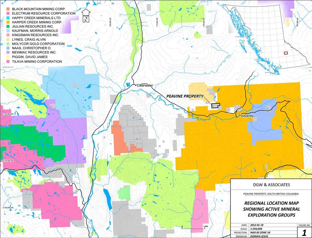
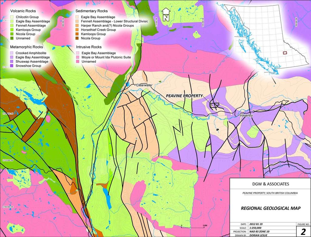
3 LIST OF TABLES TABLE 1: Peavine Claim Group 6 LIST OF FIGURES FIGURE 1: Project Location / Area Play Map FIGURE 2: Geology Map FIGURE 3: Tenure ID Map Showing Petrographic Sample Locations A1 A1 A1 APPENDIX 1. Figures DGW & Associates Peavine A Assessment Report Page 3
4 1.0 SUMMARY This report describes a program of exploration undertaken during August 2011 on the Peavine Property, 100% by DGW & Assoiciates. The property is being held in trust by James Thom. The property is located ~26 kilometers east of Clearwater B.C. of Central British Columbia. The property consists of one claim and covers an area of 1.40 km 2. DGW & Associates completed a reconnaissance trip to the Peavine property with the mandate of determining accessibility and to locate the Peavine Creek Showing indicated in the ARIS report. Five quartz carbonate vein samples were also collected from the area to be assayed and petrographicaly described in the future. The accessibility was found to be in great condition and access by 4x4 truck or ATV is easily manageable. The Peavine showing was not located on this property visit. However a number of quartz carbonate veins were identified in the Peavine Creek metabasalts. DGW & Associates Peavine A Assessment Report Page 4
5 2.0 INTRODUCTION This report has been written in order to satisfy assessment requirements for SOW: This report describes the geology, a brief work history and the program of exploration undertaken during August 2011 on the Peavine claim group, 100% owned by DGW & Associates and being held in trust by James Thom. The 2011 property visit was carried out by the author. All UTM locations given are from the NAD83 ZONE11 projection. 2.1 Property Description and Location The PEAVINE Property is located in the Kamloops Mining Division, in the Kamloops-North Thompson Electorial District, of Central British Columbia, Canada. The property covers hectares. The Peavine Property is situated on N.T.S. map sheet 082M (1:250,000), 082M/12, (1:50,000) and 082M/062, (1:20,000). The property consists of one claim group. The claim group, known as the Peavine claim group, consists of one (1) claim covering approximately hectares. The status of the claim is given in Table 1. The Peavine Property is 100% owned DGW & Associates and is being held in trust by Dorian Leslie. Figures 1 3 illustrate project location and infrastructure at two scales. 2.2 Access, Climate, Local Resources and Physiography Access to the Peavine Property is afforded by the paved road via Route #5 (Southern Yellowhead Highway) for a distance of approximately 26 kilometres east of Clearwater, BC. Driving time from Vancouver to Clearwater is approximately 6 hours. Driving distance from Clearwater to the unpaved tertiary logging road turn off is approximately 14 kilometers. The Peavine Property itself is covered by a network of variously maintained roads and trails. This access affords excellent ability to reach most areas of the Property by 4x4 or ATV vehicle. The Peavine Property is located on Mount McClennan; which is situated to the north of the North Thompson River midway between the communities of Birch Island and Vavenby. The property covers a portion of the steep south facing lower slope of the Mountain. Table 1. Peavine Claim Group OWNER CLAIM NAME TENURE # Good to date SIZE (Ha) James Thom -100%- PEAVINE /oct/07* *Good to date is based on the acceptance of this report associated with SOW: DGW & Associates Peavine A Assessment Report Page 5
6 3.0 HISTORY Where no specific reference is listed, information has been taken from the British Columbia Minister of Mines Annual reports, from the BC Geological Survey Branch Mineral Inventory File (MINFILE) and Ministry of Mines. 3.1 History of Exploration, Peavine Project Claim Group The claims were staked to include an old mineral prospect identified by Placer Dome in Assessment Reports: 12080, and The mineral prospect identified by Placer Dome but not reported in the British Columbia Ministry of Energy and Mines Minfile Showings, is located in the bed of Peavine Creek. It consists of a series of narrow sulphide rich carbonate veins which cut metabasalt immediately be a limestone interbed. The veins are rich in Au, Ag, As, Cu, Pb, Zn and Hg. Exploration on the Peavine Creek Property by Placer Dome included: geological mapping, soil sampling, stream sediment program and a VLF and Mag geophysical survey. The results from these exploration programs resulted in Placer Dome interpreting that the Peavine Creek showing has little geophycial and geochemical response. DGW & Associates Peavine A Assessment Report Page 6
7 4.0 GEOLOGY 4.1 REGIONAL GEOLOGY The regional geology of the project area is taken from Paper , BCDM Geological Fieldwork 1981, Clearwater Area by P. Schiarizza. Figure 2 shows the generalized geology of the Clearwater Area. The figure shows that claims are underlain by a package of complex deformed and metamorphosed sedimentary and volcanic strata. The package is assigned to the Lower Cambrian to Mississipian Eaglebay Formation. The assemblage includes chloritic schist and greenstone, predominantly derived from mafic volcanic and volcaniclastic strata and intercalated limestone. The greenstone unit appears to be tectonically overthrust onto a mixed predominantly metasedimentary package. The latter consists of dark grey phyllite with intercalated fine clastic sediment; light to medium greenish-grey chlorite-sericitequartz schist intercalated with siliceous sediment and light to medium grey quartzite. The sediment is locally calcareous and it contains intercalations of limestone. DGW & Associates Peavine A Assessment Report Page 7
8 EXPLORATION PROGRAM The 2011 exploration program covered in this report consisted of a reconnaissance trip to the property to find the location of the Peavine showing, determine the condition of the logging roads and collect a representative suite of rocks from the area for petrographic study. The Peavine showing was not located during this property visit but it was found that the logging roads were great condition and allow easy access by 4x4 or quad. Five quartz carbonate vein samples were also collected from the area to be assayed and petrographicaly described in the future. The locations of these samples are shown in Figure 3. DGW & Associates Peavine A Assessment Report Page 8
9 6.0 CONCLUSIONS DGW & Associates completed a reconnaissance trip to the Peavine property with the mandate of determining accessibility and to locate the Peavine Creek Showing indicated in the ARIS report. Five quartz carbonate vein samples were also collected from the area to be assayed and petrographicaly described in the future. The accessibility was found to be in great condition and access by 4x4 truck or ATV is easily manageable. The Peavine showing was not located on this property visit. However a number of quartz carbonate veins were identified in the Peavine Creek metabasalts. Recommendations: Locate the Peavine showing DGW & Associates Peavine A Assessment Report Page 9
10 7.0 Statement of Qualifications I James G.M. Thom certify that: 1. I am an independent consulting geologist residing at 118B west 14 th ave, Vancouver BC, V5Y1W5 and can be contacted at thomjgm@gmail.com 2. I obtained a B.Sc. in Earth and Ocean Sciences at the University of Victoria [2002] and graduated with a M.Sc. in Geology from the University of Toronto [2003]. 3. I have worked in the mineral exploration industry since I supervised the 2011 exploration program described in this report DGW & Associates Peavine A Assessment Report Page 10
11 8.0 STATEMENT OF COSTS Breakdown of Costs for 2011 Exploration work: SOW Personnel: James $500.00/day Rhonda $250.00/day Rentals: $100.00/day $25.00/day Consumables: Gas $25.00/person/day Analytical: Thin Section $50.00/sample Office & Engineering: 0 Report Writing GIS/Drafting/Cartography SUBTOTAL $ 4, Overhead & Project Mgt 0% of $13, TOTAL COST EXPLORATION PROGRAM $ 4, DGW & Associates Peavine A Assessment Report Page 11
12 APPENDIX 1 FIGURES
13
14
15
for the Greenwood Mining Division, B.C. NTS 82E/7W Latitude 49' 27' W, Longitude 118' 5 Prepared by a= D. Dylan Watt, B.Sc.
 t. b LOGnO: 37~ -08 m. ACTIO#: for the AMP AMP 2 AMP 3 t AMP 4 CLAIMS Greenwood Mining Division, B.C. NTS 82E/7W Latitude 49' 27' W, Longitude 8' 5 %E c,w zc *& a w Prepared by a= -4c. D. Dylan Watt, B.Sc.
PHYSICAL WORK REPORT. the BAY CLAIMS. Omineca Mining Division Smithers, British Columbia N.T.S. 93E 13E/W
 PHYSICAL WORK REPORT the BAY CLAIMS Omineca Mining Division Smithers, British Columbia a N.T.S. 93E 13E/W LATITUDE: 53 57 00 N I LONGITUDE: 127 45 OO W for Home Ventures Ltd. 1201-675 West Hastings Street
PROSPECTING REPORT THE WALLACE CLAIM OMENICA MINING DIVISION. 54" x6" 3.d d. for. Reako Exlorat ions Ltd. Wallace Rev. C.G.
 PROSPECTING REPORT ON THE WALLACE CLAIM OMENICA MINING DIVISION 54"44 14 1x6" 3.d d by David A. Howard P.Eng. for Reako Exlorat ions Ltd. Claim Locat ion Wallace Rev. C.G. #1560 Dome Mountain Area 9 3
for the Greenwood Mining Division, B.C. NTS 82E/7W 29' W, Longitude 118' 53' N Prepared by D. Dylan Watt, B.Sc.
 for the FltE NO: u VOLT 1, VOLT 2, VOLT 3, & VOLT 4 CLAIMS Greenwood Mining Division, B.C. NTS 82E/7W Latitude 49' 29' W, Longitude 118' 53' N Prepared by D. Dylan Watt, B.Sc. #309-1996 Trutch Street Vancouver,
Prospecting Report 'S Office i DB Property, B.C. -J Negro Creek Nelson Mining District NTS 82F.050. Operator: Kootenay Gold Inc.
 . '.' I"' i9 12 Prospecting Report 'S Office i DB Property, B.C. -J Negro Creek Nelson Mining District NTS 82F.050 Operator: Kootenay Gold Inc. Owner: Darlene Lavoie Work Performed Summer of 2007 Report
NTS 082F03SW N W U E N
 Prospecting Report JOCELYN CLAIM NTS 082F03SW N49 09 51 W 117 14 04 11U 482906E 5445737N NELSON MINING DIVISION Martin Ross PO Box 323 Salmo BC V0G 1Z0 Jan 31, 2012 PROSPECTING REPORT JOCELYN MINERAL CLAIM
2013 GEOLOGICAL ASSESSMENT REPORT SHERIDAN HILL PROPERTY
 2013 GEOLOGICAL ASSESSMENT REPORT ON THE SHERIDAN HILL PROPERTY NEW WESTMINSTER MINING DIVISION BRITISH COLUMBIA NTS 092G07 49 16 31 NORTH LATITUDE, 122 39 48 WEST LONGITUDE PREPARED FOR Sheridan Hill
ASSESSMENT REPORT TITLE PAGE AND SUMMARY
 ASSESSMENT REPORT TITLE PAGE AND SUMMARY TITLE OF REPORT: Assessment Report on Andys Bridge Mineral Claim, Turnagain River Area TOTAL COST: $2,100 AUTHOR(S): Bruce w Downing SIGNATURE(S): Bruce W Downing
1 FILMED 1. FILE NO:!..rsrru -* -. GRAND TWO CLAIM
 FILE NO:!..rsrru -* -. GRAND TWO CLAIM REPORT ON 1993 ASSESSMENT WORK GRAND TWO CLAIM REC. NO. 301849 NELSON MINING DIVISION NTS MAP SHEET 82F6/W 49 25'51" NORTH 117 18'08" WEST 1 FILMED 1 AUTHOR: R. Jordan,
PRECIOUS METALS. owner. JMT Services Corp. GEOCHPlICAL SAMPLING CHELASLIE WCE, NORTH CENTRAL, B.C. OMINECA MINING DIVISION NTS 93F/5E & 6W
 PRECIOUS METALS REPORT ON 1980 RECONNAISSANCE GEOCHPlICAL SAMPLING CHELASLIE WCE, NORTH CENTRAL, B.C. OMINECA MINING DIVISION NTS 93F/5E & 6W LATITUDE 53O28 N LONGITUDE 125O31 W DATES Qp WORK: JULY 10
BLURTON CREEK NICKEL PROPERTY. (Minfile # 082LNW-039)
") 5489153 BLURTON CREEK NICKEL PROPERTY (Minfile # 082LNW-039) Mara Lake Area / Salmon Arm B.C NTS - 82L-11 (UTM 83/Z10, 357690E, 5614220N) Prepared by: Jim Cuttle, B.Sc., P.Geo. 86 Cloudburst Road Whistler,
5489153 BLURTON CREEK NICKEL PROPERTY (Minfile # 082LNW-039) Mara Lake Area / Salmon Arm B.C NTS - 82L-11 (UTM 83/Z10, 357690E, 5614220N) Prepared by: Jim Cuttle, B.Sc., P.Geo. 86 Cloudburst Road Whistler,
GEOLOGICAL MAPPING REPORT ON THE ASH MINERAL CLAIM OSOYOOS MINING DIVISION ASHNOLA RIVER MAP SHEET NTS M092,H019 MCBRIDE CREEK AREA, ASHNOLA RIVER,
 GEOLOGICAL MAPPING REPORT ON THE ASH MINERAL CLAIM OSOYOOS MINING DIVISION ASHNOLA RIVER MAP SHEET NTS M092,H019 LATITUDE 49 o O6, LONGITUDE 120 o 22 MCBRIDE CREEK AREA, ASHNOLA RIVER, KEREMEOS, B.C. CANADA
ASSESSMENT REPORT TITLE PAGE AND SUMMARY
 ASSESSMENT REPORT TITLE PAGE AND SUMMARY TITLE OF REPORT: 2016 Prospecting Report Sphynx Claim TOTAL COST: $167.56 AUTHOR(S): Giacomo Grassi SIGNATURE(S): NOTICE OF WORK PERMIT NUMBER(S)/DATE(S): STATEMENT
ASSESSMENT REPORT PROSPECTING PROGRAM ION/DIRTY JACK PROPERTY NELSON MINING DIVISION N.T.S. MAP SHEET 82F.023 UTM COORDINATES N E
 ASSESSMENT REPORT PROSPECTING PROGRAM ION/DIRTY JACK PROPERTY NELSON MINING DIVISION N.T.S. MAP SHEET 82F.023 UTM COORDINATES 5454800N - 0455235E Work Performed Summer 2007 OWNER >* ' Tom Kennedy >8 404-22
GEOPHYSICAL SURVEY ON THE BADGER PROJECT
 GEOPHYSICAL SURVEY ON THE BADGER PROJECT SIMILKAMEEN MINING DIVISION BRITISH COLUMBIA NTS 092H 10 UTM Zone 10, NAD 83 650,500mE / 5,489,800mN Prepared for: DGW Consultants #1108 1111 Alberni Street, Vancouver,
Lat. 52' 43' N Long ' W
 &A exploration ltd MINING ENGINEERING GEOLOGY- GEOPHYSICS 4570 HOSKINS ROAD, NORTH VANCOUVER, 6. C. TELEPHONE (804) 985,7921 V7K 2R1 GEOLOGICAL AND GEOCHEMICAL REPORT on the BLUE CLAIMS Cariboo Mining
Verification Rock Geochemical Survey on the Casino Property
 Verification Rock Geochemical Survey on the Casino Property Trail Creek Mining Division British Columbia NTS 082F04 Latitude 49 04 40.3 North Longitude 117 39 1.4 West UTM Zone 11, NAD 83 5436320N 452500E
ASSESSMENT REPORT TITLE PAGE AND SUMMARY
 ASSESSMENT REPORT TITLE PAGE AND SUMMARY TITLE OF REPORT: 2016 Prospecting Report Mystery Beryl TOTAL COST: $1299.09 AUTHOR(S): Giacomo Grassi SIGNATURE(S): NOTICE OF WORK PERMIT NUMBER(S)/DATE(S): STATEMENT
RECONNAISSANCE GEOCHEMICAL SURVEY
 RECONNAISSANCE GEOCHEMICAL SURVEY LEGAL, RITA, LOUISE FR. (CHAPLEAU GROUP) REVERTED CROWN GRANTS CHAPLEAU CREEK AREAJ, SLOC& MINING DIVISION 82 F/11W Lat: 49'44" Long: 117"22'W MINERAL RESOURCES BRANCH
PROSPECTORS ASSISTANCE PROGRAM MINISTRY OF ENERGY AND MINES
 BRITISH COLUMBIA PROSPECTORS ASSISTANCE PROGRAM MINISTRY OF ENERGY AND MINES GEOLOGICAL SURVEY BRANCH PROGRAM YEAR: 1999/2000 REPORT #: PAP 99-l 6 NAME: KIM ANSCHETZ PROSPECTORS TlEPORT on the 99 LOUIS
GEOPHYSICAL REPORT ON THE PRINCE GEORGE PORPHYRY PROJECT LYNX PROPERTY
 GEOPHYSICAL REPORT ON THE PRINCE GEORGE PORPHYRY PROJECT LYNX PROPERTY Lynx Property Omenica Mining Division British Columbia Tenure # 841107, 742942, 741962 NTS Sheet 093K MTO Event Number - 5434711 UTM
GEOPHYSICAL REPORT CHU CHUA PROJECT Green Mountain Group. KAMLOOPS MINING DIVISION NTS 92P/8E, 82M/5W Lat: 51'24' N Long: 120'00' w
 I GEOPHYSICAL REPORT CHU CHUA PROJECT Green Mountain Group KAMLOOPS MINING DIVISION NTS 92P/8E, 82M/5W Lat: 51'24' N Long: 120'00' w I rvm #.,_..._..._._._.- $...-...! 1 VANCOUVER, B.C. 1 G E 0 I, 0.G
CONSULTING GEOLOGICAL 8: MINING ENGINEERS STINGS STREET DA V6E 2E9 GEOPHYSICAL SURVEY SILVER QUEEN 2 ZEBALLOS AREA. B.C.
 DOLMAGE CAMPBELL & ASSOCIATES (1 975) LTD. CONSULTING GEOLOGICAL 8: MINING ENGINEERS STINGS STREET DA V6E 2E9 '' 1E O L 0 G I C A.L B'x;&a:f2:#& 'SESSMENT REPObT 12, Assessment RESOURCES LTD. 111 ReDort
First Year assessment Report on Prospecting and Rock sampling, King George property, License M NTS 12A/05 Newfoundland and Labrador.
 First Year assessment Report on Prospecting and Rock sampling, King George property, License 016679M NTS 12A/05 Newfoundland and Labrador. Submitted by Shawn Rose For Shawn Rose January 2011 Work year
ASSESSMENT REPORT TITLE PAGE AND SUMMARY
 ASSESSMENT REPORT TITLE PAGE AND SUMMARY TITLE OF REPORT: 2016 Prospecting Report Midas Claim TOTAL COST: $314.61 AUTHOR(S): Giacomo Grassi SIGNATURE(S): NOTICE OF WORK PERMIT NUMBER(S)/DATE(S): STATEMENT
UNION MINIERE EXPLORATIONS AND MINING CORPORATION LIMITED ASSESSMENT REPORT ON FITINAT MINERAL CLAIM. Alberni Mining Division Record No.
 M F )( UNION MINIERE EXPLORATIONS AND MINING CORPORATION LIMITED Suite 200, 4299 Canada Way, Burnaby, B.C. V5G 1 H4 Telephone (604) 437-9491 ASSESSMENT REPORT ON GEOCHEMICAL SOIL SURVEYS AND ROCKSAMPLING
Serengeti Resources Inc GEOCHEMICAL REPORT ON THE SHADOW PROPERTY a.
 Serengeti Resources Inc. 2004 GEOCHEMICAL REPORT ON THE SHADOW PROPERTY a. Located in the Johanson Lake Area Omenica Mining Division NTS 94D/9 6 degrees and 32 minutes North Latitude 126 degrees and 2
GEOCHEMICAL STREAM SAMPLING. on the PLACER LEASES NO. Jordan River/Bear Creek Area. Victoria Mining Division. Latitude 48 degrees 32 minutes N.T.S.
 GEOCHEMCAL STREAM SAMPLNG on the PLACER LEASES NO P. 8149, 8150, 8151, 8152, 8161, 8162, 8163, 8400, 10844, 10845 Jordan River/Bear Creek Area Victoria Mining Division Latitude 48 degrees 32 minutes Longitude
Compilation Report Hawke Hill South. Licence No M NTS 01N/06. Newfoundland and Labrador. Submitted by Gordon E. Cooper and Kevin P.
 Compilation Report 2010 Hawke Hill South Licence No. 017282M NTS 01N/06 Newfoundland and Labrador Submitted by Gordon E. Cooper and Kevin P. Ryan For Kevin P. Ryan (Licence holder) January, 2011 Work Year:
CONTENTS. Location, Access and History...6. Tenure Status and Geology Regional Andy Property Geology Map...9
 TYPE OFWORK IN THIS REPORT EXTENT OF WORK (rn METRTC UNITS) ON WHICH CLAIMS PROJECT COSTS APPORTIONED (incl. support) GEOLOGICAL (scale, area) Ground, mapping Photo interpretation GEOPHYSICAL (line-kilometres)
PROSPECTING REPORT. Silver Dollar Property. EVENT # TENURE # Tenure Name: GPEX Silver Dollar
 2008-2009 PROSPECTING REPORT Silver Dollar Property EVENT # 4267989 TENURE # 555462 Tenure Name: GPEX Silver Dollar Similkameen Mining Division Map 092H Central Coordinate Reference 120 06 26.9 W Longitude
VLF and GRADIOMETER SURVEY OVER THE CAT GROUP, INVERMERE AREA GOLDEN MINING DIVISION, BRITISH COLUMBIA NTS 82K/O8W LAT/LONG 50 29' ' FOR
 VLF and GRADIOMETER SURVEY OVER THE CAT GROUP, INVERMERE AREA GOLDEN MINING DIVISION, BRITISH COLUMBIA NTS 82K/O8W LAT/LONG 50 29' - 116 15' FOR W. POCHYLKO STETTLER, ALBERTA BY T.R.B. DUNDAS ISOGEOS EXPLORATION
Reconnaissance. Of the. Denis mineral claims. Situated at Kilometer 844 of the Alaska Highway. Liard Mining Division. Northeastern British Columbia
 Reconnaissance Of the Denis mineral claims Situated at Kilometer 844 of the Alaska Highway Liard Mining Division Northeastern British Columbia N.T.S. 94M.075 Latitude 59 42 25 Longitude 127 13 12 Field
NTS 93L/9W GEOCHEMICAL AND GEOPHYSICAL REPORT MONA CLAIM OMINICA MINING DIVISION. Lati tude 54036'N; Longitude 'W
 GEOCHEMICAL AND GEOPHYSICAL REPORT ON MONA CLAIM OMINICA MINING DIVISION Lati tude 54036'N; Longitude 126018'W NTS 93L/9W April 1981 Paul Plicka Consulting Geologist LOCATION MAP INTRODUCTION TABLE OF
SECOND and THIRD YEAR ASSESSMENT REPORT PROSPECTING LICENCE M, ROCK CUT PROPERTY, NTS 1N/12, NEWFOUNDLAND. ROY FRENCH (licence holder )
") SECOND and THIRD YEAR ASSESSMENT REPORT Of PROSPECTING On LICENCE 013704M, ROCK CUT PROPERTY, NTS 1N/12, NEWFOUNDLAND. By ROY FRENCH (licence holder ) Work Conducted: Sept. 17, 2008 Nov. 03, 2009 Total
SECOND and THIRD YEAR ASSESSMENT REPORT Of PROSPECTING On LICENCE 013704M, ROCK CUT PROPERTY, NTS 1N/12, NEWFOUNDLAND. By ROY FRENCH (licence holder ) Work Conducted: Sept. 17, 2008 Nov. 03, 2009 Total
A GUIDE TO WRITING AN ASSESSMENT REPORT ON YOUR CLAIMS
 A GUIDE TO WRITING AN ASSESSMENT REPORT ON YOUR CLAIMS PLEASE NOTE! In the following pages, suggestions and advice are in italics, under each heading. Use as a guideline only. Items in bold should be changed
1 CLAIMS GEOPHYSICAL REPORT ON BOYAL SITUATE NORTHEAST OF TILLICUM MOUNTAIN GOLD AREA BURTON - NAKUSP SIQCAEJ MINING DIVISION
 GEOPHYSICAL REPORT ON BOYAL 1 CLAIMS SITUATE NORTHEAST OF TILLICUM MOUNTAIN GOLD AREA BURTON - NAKUSP SIQCAEJ MINING DIVISION CONSULTING GEOLOGIST AUGUST 1983 VANCOUVER B *C INDEX INTRODUCTION ooa,.eoaaa.aaaoaaooaoa~ao~o
490 20' 30" North Latitude ' 30" West Longitude
 _._.. I CONSULTING GEOLOGISTS 605-602 WEST HASTINGS STREET, VANCOUVER, B.C. V6B 1P2 TELEPHONE: (604) 689-5533 6 I F: ASSESSMENT REPORT ON THE PATSY 1 MINERAL CLAIM ' '?%2% I WHISTLE CREEK, HEDLEY ARE L-l-
BALFOUR MINING LTD. (N.P.L.) HAM GROUP 92-P-6, CLINTON M. D.8 B. C. Lat 51 17'N, GEOCHEMICAL REPORT. V. CUKOR, P. Eng.
 HAM GROUP 92-P-6, CLINTON M. D.8 B. C. Lat 51 17'N, GEOCHEMICAL REPORT. V. CUKOR, P. Eng.") 34q '7 BALFOUR MINING LTD. (N.P.L.) HAM GROUP 92-P-6, CLINTON M. D.8 B. C. Lat 51 17'N, Long 12lo14'W GEOCHEMICAL REPORT, V. CUKOR, P. Eng. January 31, 1972 TABLE OF CONTENTS 1. INTRODUCTION 2. PROPERTY,
34q '7 BALFOUR MINING LTD. (N.P.L.) HAM GROUP 92-P-6, CLINTON M. D.8 B. C. Lat 51 17'N, Long 12lo14'W GEOCHEMICAL REPORT, V. CUKOR, P. Eng. January 31, 1972 TABLE OF CONTENTS 1. INTRODUCTION 2. PROPERTY,
Prospecting Report Grandpa Claim Group
 2010 2011 Prospecting Report Grandpa Claim Group TENURE NUMBER: 705523 EVENT NUMBER: 4825383 TENURE NAME: GRANDPA Lillooet Mining Division Map 092I Central Coordinate Reference 50 57 30 N Latitude 121
REPORT ON MAGNETOMETER SURVEY TIK-1 CLAIM e&f KAMLOOPS MINING DTVISION. by D. Hendry D. C. MILLER. February 3, for
 REPORT ON MAGNETOMETER SURVEY TIK-1 CLAIM 92-1-14 e&f KAMLOOPS MINING DTVISION lat. 50 57 ' 12" long. 121O23 ' 37" OWNER: ST. JOSEPH EXPLORATIONS LIMITED OPERATIOR: ST. JOSEPH EXPLORATIONS LIMITED by D.
VANCOUVER, B.C. Tri 082F/ F/059
 GEOCHEMCAL REPORT t MAY L, 2006 Whbpper Mineral Claims Ailsa Lake Area Gold comm~ss16fl8f"s Offim on Mining Division VANCOUVER, B.C. Tri 082F/058 082F/059 3792 E 5486438 N Operator Kootenay Gold nc. Suite
SELF POTENTIAL SURVEY OVER THE JAY GROUP, INVERMERE AREA GOLDEN MINING DIVISION, BFUTISH COLUMBIA NTS 82W8W7 82W9W LATLONG 50 30' ' FOR
 - GEOLOGICAL SURVEY BRANCH ASSESSMENT REPORTS -- -- DATE RECEI?/::D 06T 10 1996 - SELF POTENTIAL SURVEY OVER THE JAY GROUP, INVERMERE AREA GOLDEN MINING DIVISION, BFUTISH COLUMBIA NTS 82W8W7 82W9W LATLONG
Date Submitted: June General Nature of Report: Examination of Placer Samples
 General Nature of Report: Examination of Placer Samples Claim: Gold Channel, Record Number 3775!8 1 (Gold Channel Placer Property) Mining Division: Cariboo NTS 093 G 09 W and E Latitude 520 23 N' Longitude1210
GEOLOGICAL MAPPING OF SKARNS ON THE SHEEP AND EWE CLAIMS, TURNAGAIN RIVER, B.C. DURING THE 1979 SUMMER SEASON
 GEOLOGICAL MAPPING OF SKARNS ON THE SHEEP AND EWE CLAIMS, TURNAGAIN RIVER, B.C. DURING THE 1979 SUMMER SEASON CLAIMS: Sheep 1 to 4 Ewe 1, 3, 4 to 8 Lamb 12 Fraction Liard Mining Division, B.C. NTS 104
ON THE LOST GOLD PROPERTY
 ON THE LOST GOLD PROPERTY NELSON MINING DIVISION BRITISH COLUMBIA Latitude: 49 18 North Longitude: 117 29.West TRIM MAPS: 82F1023,033 NTS: 8tF/5,6 By: Fred Critchlow . TABLE OF CONTENTS r PAGE lutroduction
51 46'N Latitude, 119'44'1;!
 COMI)!CO LTD. EXPLORATION NTS: 82 1'1/13E GEOCHEKICAL ASSESSMENT REPORT ON THE SI 1 MINERAL CLAIM in the Kamloops Mining Division 51 46'N Latitude, 119'44'1;! Longitude Work Period: June 25, 1979 - July
121 deg 44' W and 53 deg 07' N
 M.R. #. R... VANCOUVER, B.C. REPORT ON THE WILLOW AND WILLOW I CLAIMS RECORD NO. 8475 AND 8476 CARIBOO MINING DIVISION NTS 93 H/4 121 deg 44' W and 53 deg 07' N 'W OWNER AND OPERATOR: RUZA RESOURCES LTD.
Negro Creek Fort Steele Minina Division. CRAIG KENNEDY Prospector
 AUG and SKAY Claims Negro Creek Fort Steele Minina Division NTS 82 F8/E Latitude 49O28 N Lonqi tude 116 Ol W BY CRAIG KENNEDY Prospector September 5, 1996 TABLE OF CONTENTS Page 1.00 INTRODUCTION 1.10
ASSESSMENT REPORT ON THE VLF-EM SURVEY. Trail Creek Mining Division NTS: 82 F/4 W Longitude: 1 17' 49' 50" Latitude: 49O 03' 40"
 ASSESSMENT REPORT ON THE JERO 5 MINERAL CLAIM ROSSLAND, BRJTISH COLUMBIA VLF-EM SURVEY Trail Creek Mining Division NTS: 82 F/4 W Longitude: 1 17' 49' 50" Latitude: 49O 03' 40" Owner: Operator: Author:
Beekeeper Property The Geology South of Mint Lake. Cariboo Mining Division
 Beekeeper Property The Geology South of Mint Lake NTS: 93A/6 Cariboo Mining Division Claims: Beekeeper 1 #I2055 Beekeeper 2 #3892 Beekeeper 3 #7895 Beekeeper 4 #8503 Latitude: Longitude: 52 degrees 24
Daiwan Engineering Ltd Granville strees V.ncouver, B. C. cuudr WY 1GS. M e : (604) PROSPECTING REPORT ON THE KING MINERAL CLAIMS
 PROSPECTING REPORT ON THE KING MINERAL CLAIMS") 1030-609 Granville strees V.ncouver, B. C. cuudr WY 1GS M e : (604) 688-1508 PROSPECTING REPORT ON THE KING MINERAL CLAIMS NORTH VANCOUVER ISLAND, BRITISH COLUMBIA NTS: 92Lj13E Latitude: 50" 47' Longitude:
1030-609 Granville strees V.ncouver, B. C. cuudr WY 1GS M e : (604) 688-1508 PROSPECTING REPORT ON THE KING MINERAL CLAIMS NORTH VANCOUVER ISLAND, BRITISH COLUMBIA NTS: 92Lj13E Latitude: 50" 47' Longitude:
Geology 12 FINAL EXAM PREP. Possible Written Response Exam Questions
 Geology 12 FINAL EXAM PREP Possible Written Response Exam Questions Use this study guide to prepare for the written response portion of the final exam. Name FINAL EXAM - POSSIBLE WRITTEN RESPONSE QUESTIONS
PROSPECTING REPORT. Broken Hill Property. EVENT # TENURE # Tenure Name: Broken Hill. New Westminster Mining Division Map 092H
 2009-2010 PROSPECTING REPORT Broken Hill Property EVENT # 4514071 TENURE # 600988 Tenure Name: Broken Hill New Westminster Mining Division Map 092H Central Coordinate Reference 121 24 26.2 W Longitude
EXPLORATION and DEVELOPMENT REPORT. Conrad Creek. PLACER and MINERAL CLAIMS SOUTHEAST BRITISH COLUMBIA
 EXPLORATION and DEVELOPMENT REPORT on Conrad Creek PLACER and MINERAL CLAIMS in SOUTHEAST BRITISH COLUMBIA Ed Friesen, BSc.E.E., P. Eng 8 Lake Placid Rise SE Calgary, Alberta T2J 5B5 April 2009 1 P age
Structural Analysis Using Hillshade Imagery. on the. LLC Property
 Structural Analysis Using Hillshade Imagery on the LLC Property Liard Mining Division NTS 104F/16W Latitude: 57 53' 47'' N Longitude: 132 03' 06'' W Owner Garry John Payie 3714 Raymond Street South, Victoria,
TECHNICAL REPORT. JUDY 1 (tenure no ) MCDAME MTN (tenure no ) LIARD MINING DIVISION BRITISH COLUMBIA, CANADA NTS 104P
 MCDAME MTN (tenure no ) LIARD MINING DIVISION BRITISH COLUMBIA, CANADA NTS 104P") TECHNICAL REPORT JUDY 1 tenure no. 735182) MCDAME MTN tenure no. 821402) LIARD MINING DIVISION BRITISH COLUMBIA, CANADA NTS 104P UTM Zone 9) E, N Event No. 5400212 Owner: Operator: Stephen Gerald Gerry)
TECHNICAL REPORT JUDY 1 tenure no. 735182) MCDAME MTN tenure no. 821402) LIARD MINING DIVISION BRITISH COLUMBIA, CANADA NTS 104P UTM Zone 9) E, N Event No. 5400212 Owner: Operator: Stephen Gerald Gerry)
Mines Act Permit MX km East of Dease Lake, B.C. in the Skeena Mining Division. NTS Location at 1:50,000 Scale NAD 27 Base Map 104I 7
 TECHNICAL ASSESSMENT REPORT on the JEDWAY PROPERTY Mines Act Permit MX-1-904 62 km East of Dease Lake, B.C. in the Skeena Mining Division NTS Location at 1:50,000 Scale NAD 27 Base Map 104I 7 Centered
REPORT. on the. Omineca Mining Division, British Columbia. Latitude N., Longitude W. NTS map sheet 93F/7E. James W. McLeod, P.Geo.
 REPORT on the CHU MOLYBDENUM PROPERTY Omineca Mining Division, British Columbia Latitude 53 21 N., Longitude 124 37 W. NTS map sheet 93F/7E James W. McLeod, P.Geo. on behalf of Mr. Chris Delorme TABLE
Geochemical and Prospecting Report on the. Lanark Property LIBERTY INTERNATIONAL MINERAL CORPORATION CLAIMS
 Geochemical and Prospecting Report on the Lanark Property LIBERTY INTERNATIONAL MINERAL CORPORATION CLAIMS NELSON/REVELSTOKE MINING DIVISION BRITISH COLUMBIA LATITUDE N51*13, LONGITUDE W117*44 UTM 448841E/
FILE NO. ASSESSMENT REPORT VLF-EM GEOPHY S I CS BUCK CLAIMS. Moyie River and Perry Creek Area FORT STEELE MINING DIVISION. NTS 82 F/8 E and 82 G/5 W
 FILE NO. ASSESSMENT REPORT on - VLF-EM GEOPHY S I CS BUCK CLAIMS Moyie River and Perry Creek Area FORT STEELE MINING DIVISION NTS 82 F/8 E and 82 G/5 W Latitude 49 27' N Longitude 116 03' W PETER KLEWCHUK
49" 3-4 I4 I \ Y 59 tj
 ASSESSMENT REPORT Mary 4 FORT STEELE M.D. NTS 82G/5W 49" 3-4 4 \ Y 59 tj Owner: St. Eugene Mining Corporation Limited Operator : St. Eugene Mining Corporation Limited Author: John R. Wilson Date Submitted:
PROSPECTING REPORT. Karen Creek. EVENT # TENURE # Tenure Name: Karen Creek. New Westminster Mining Division Map 092H
 2008-2009 PROSPECTING REPORT Karen Creek EVENT # 4269354 TENURE # 578618 Tenure Name: Karen Creek New Westminster Mining Division Map 092H Central Coordinate Reference 121 17 30.7 W Longitude 49 26 21.9
The Cobalt Rainbow. Airborne geophysical maps show that a north trending aeromagnetic high suggests further undiscovered mineralisation.
 The Cobalt Rainbow The property is located on Greenstone Creek, approximately 4.8 kilometres south west of the creek mouth. The property is located about 24 km due west of Campbell River, in the east-central
KEN ELLERBECK PLUG CLAIM GROUP EVENT #
 KEN ELLERBECK December 11, 2017 Page 47 of 48 KEN ELLERBECK December 11, 2017 Page 48 of 48 KEN ELLERBECK (Owner & Operator) TECHNICAL EXPLORATION REPORT (Event #5670220) on PROSPECTING and EXPLORING Work
PROSPECTING REPORT. Medallion Property. EVENT # TENURE # Tenure Name: GPEX CLVIII Medallion
 2006-2007 PROSPECTING REPORT Medallion Property EVENT # 4167980 TENURE # 540362 Tenure Name: GPEX CLVIII Medallion Watson Bar Region Clinton Mining Division Map 092O Central Coordinate Reference Long.
EMORY PLACER CLAIM Yale Region New Westminster Mining Division
 EMORY PLACER CLAIM Yale Region New Westminster Mining Division EVENT # 4646011 TENURE # 608187 Tenure Name: Emory NTS Map 92H/11 Approximate Centre of Tenure 121 25 12 W Longitude 49 30 44 N Latitude Report
PROSPECTING REPORT TENURES # / / CLAIM NAMES OLD SETTLER; OLD SETTLER1; OLD SETTLER2
 2011 PROSPECTING REPORT EVENT - 5160426 TENURES # 688183 / 691903 / 691905 CLAIM NAMES OLD SETTLER; OLD SETTLER1; OLD SETTLER2 COAST CRYSTALINE BELT REGION NEW WESTMINSTER MINING DISTRICT MAP - 092H GPS
Assessment Report #
 Table Of Contents Event Sheet #5576884 Exploration Program for 2015 Summery Introduction Location and Access Climate Local Resources and infrastructure Physiography Property Bedrock Geology History of
PROSPECTING REPORT PLACER CLAIM - FOX 4 SIMILKAMEEN MINING DIVISION MAP - 092H GPS COORDINATE REFERENCE CENTER OF CLAIM ' 6"N, 120.
 2011 PROSPECTING REPORT PLACER CLAIM - FOX 4 TENURE #793322 EVENT #5160421 SIMILKAMEEN MINING DIVISION MAP - 092H GPS COORDINATE REFERENCE CENTER OF CLAIM 49. 24' 6"N, 120. 36* 30" W REPORT PREPARED BY
vox 1wo LOG NO: SEP 1 019% RD. &CTlON. JG-1, PILOT GOLD, PILOT GOLD 1 h 2. AND GOLD WING 1 TO 6 CLAIMS for HAROLD ADAMS Box 1329 Princeton, B.C.
 LOG NO: SEP 1 019% RD. &CTlON. JG-1, PLOT GOLD, PLOT GOLD 1 h 2. AND GOLD WNG 1 TO 6 CLAMS r Weyrnan Creek Area Kamloops Mining Division 82L-5W (50O22' N. Lat., 119O59' W. Long.) for HAROLD ADAMS Box 1329
AiG ON THE EASTRIM mm. Record number KENNJZDY LAKE AREA - ALBERNI MINING DIVISION Map 92Fl3 W
 ON THE EASTRIM mm CLAIM Record number 3799 19 KENNJZDY LAKE AREA - ALBERNI MINING DIVISION Map 92Fl3 W 125" 23' West Lbngitude - 49" 09' North Latitude Walter GUPPY August ZO;i;! t I : AiG272002 TABLE
R.A. COMINCO LTD. EXPLORATION NTS: 92H/16. WESTERN DISTRICT January 6, 1982 ASSESSMENT REPORT 1981 SOIL GEOCHEMISTRY ON THE TROUT PROPERTY
 COMINCO LTD. EXPLORATION NTS: 92H/16 WESTERN DISTRICT January 6, 1982 ASSESSMENT REPORT 1981 SOIL GEOCHEMISTRY ON THE TROUT PROPERTY (Trout 1 and 6 Claims) SIWASH LAKE AREA, SIMILKAMEEN M.D., B.C. (Work
PHYSICAL WORK REPORT ON THE. KINGDOMlwINERAL LILLOOET MINING DIVISION. NTS Map Sheet 92J/15W. Co-Ordinates North: East
 PHYSICAL WORK REPORT ON THE KINGDOMlwINERAL CLAIM LILLOOET MINING DIVISION NTS Map Sheet 92J/15W Co-Ordinates North: 50 48 East 120 48 For Assessment Work BY Edward Skoda October 15,2002 Vancouver, British
GEOLOGICAL BRAN ASSESS
 TITLE PAGE This report covers assessment work performed on the Mundy group, located in the Boundary Creek area, north of Greenwood, British Columbia. The work comprises of THM soil testing, trenching and
Technical Report. Geochemical Sampling of Raymond Creek on Vancouver Island. Victoria Mining District 092C 15. UTM Co-ordinates N E
 Technical Report Geochemical Sampling of Raymond Creek on Vancouver Island Victoria Mining District 092C 15 UTM Co-ordinates 5414044N 389836E Owner of Claims is Dean Arbic(133434) Report Written by Dean
PERCY CONTRACTING SERVICES LTD.
 GEOLOGICAL REPORT ON TEN PLACER LEASES (3139, 3140, 3141, 3142, 3143, 3144, 3145, 3146, 3147, 3148) MOREHEAD CREEK CARIB00 MINING DIVISION, B.C. 938/12W (52 38 N, 121 47 W) For PERCY CONTRACTING SERVICES
NEW HAZELTON, OMINECA M.D.,
 PROSPECTING REPORT JUDI 1 TO 6 MINERAL CLAIMS NEW HAZELTON, OMINECA M.D., B.C. MAP 93M/4E, LAT. SS014'N, LONG. 127'33'W OWNED BY: A. L'ORSA ANTHONY L'ORSA Smithers, B.C. 21 February, 1981 TABLE OF CONTENTS
Table of Contents. Title Page and Summary
 1 2 Table of Contents Page 1&2 Title Page and Summary Page 3 Table of Contents Page 4 Cover Page Page 5 Summary and Introduction Page 6 Location/Location Map Page 7 Claim Location Map Page 8 Claim Status/Property
O ITHIS )WE OF WORK IN I EXTENT OF WORK I I PROJECT COSTS I ON WHICH CLAIMS (IN METRIC UNITS) APPORTIONED (id. support) GEOLOGICAL (scale, area)
WE OF WORK IN I EXTENT OF WORK I I PROJECT COSTS I ON WHICH CLAIMS (IN METRIC UNITS) APPORTIONED (id. support) GEOLOGICAL (scale, area)") Geological Survey Branch TITLE OF REPORT [type of SUNOY(S)] TOTAL COST 1 MINERAL INVENTORY M OWNER@) MAILING ADDRESS -.,-- a 5 -a OPERATOR(S) [who paid ffo the wnk) 2) MAILING ADDRESS 76e2 HWY 97/gm LP
Geological Survey Branch TITLE OF REPORT [type of SUNOY(S)] TOTAL COST 1 MINERAL INVENTORY M OWNER@) MAILING ADDRESS -.,-- a 5 -a OPERATOR(S) [who paid ffo the wnk) 2) MAILING ADDRESS 76e2 HWY 97/gm LP
GOLDSTAR PROPERTY LUMBY, BC
 SUMMARY REPORT ON THE GOLDSTAR PROPERTY LUMBY, BC Vernon Mining District NTS 82L 7/W
SOIL GEOCHEMISTRY. OK-ll AND OK-Ill MINERAL CLAIMS MOUNT THOEN AREA OMINECA MINING DIVISION, B.C. NTS 93 MI6 E & 7 W
 SOIL GEOCHEMISTRY OK-ll AND OK-Ill MINERAL CLAIMS MOUNT THOEN AREA OMINECA MINING DIVISION, B.C. NTS 93 MI6 E & 7 W LATITUDE 55O23'N, LONGITUDE 127 01W Locke B. Goldsmith, P.Eng. Consulting Geologist December
TOPOGRAPHICAL SURVEY REPORT ON THE GREENDROP PROPERTY NEAR CHILLIWACK, B.C. 92-H-3/W
 TOPOGRAPHICAL SURVEY REPORT ON THE GREENDROP PROPERTY NEW WESTMINSTER M.D. NEAR CHILLIWACK, B.C. 92-H-3/W Location: The central pap of the claims is located at coordinates 49 08'N, latitude by 121 26'W,
PROSPECTING REPORT. Deneau Creek. EVENT # TENURE # Tenure Name: Deneau Creek. New Westminster Mining Division Map 092H
 2010-2011 PROSPECTING REPORT Deneau Creek EVENT # 4844921 TENURE # 578616 Tenure Name: Deneau Creek New Westminster Mining Division Map 092H Central Coordinate Reference 121 18 04.5 W Longitude 49 26 13.9
COMINCO LTD. HORIZONTAL LOOP EM AND MAGNETIC SURVEYS ON SHA. CLAIMS 1, 2, 7 and 8 NELSON AND FORT STEELE MINING DIVISIONS, B.C.
 COMINCO LTD. EXPLORATION WESTERN DISTRICT NTS: 82-F/1 HORIZONTAL LOOP EM AND MAGNETIC SURVEYS ON SHA CLAIMS 1, 2, 7 and 8 - ASSESSMENT REPORT - NELSON AND FORT STEELE MINING DIVISIONS, B.C. Latitude Longitude
LAFOREST-HLAVA EXPLORATION SERVICES LTD. (705)
") !d LAFOREST-HLAVA EXPLORATION SERVICES LTD. (705) 268-25 I-) REPORT ON GEOLOGICAL MAPPING AND. ON THE HORNE CLAIM RECORD NO. 639 REVELSTOKE MINING DIVISION NTS 82 K/4W 'zr 'I LATITUDE 50' a"% LONGITUDE
!d LAFOREST-HLAVA EXPLORATION SERVICES LTD. (705) 268-25 I-) REPORT ON GEOLOGICAL MAPPING AND. ON THE HORNE CLAIM RECORD NO. 639 REVELSTOKE MINING DIVISION NTS 82 K/4W 'zr 'I LATITUDE 50' a"% LONGITUDE
GEOLOGICAL BRANCH ASSESSMENT REPORT 12. FItE NO: ACTION: THE GOLDEN MINING DIVISION, GOLDEN, Including THE NTS MAP; M82K/15W
 ACTION: FItE NO: Including 1990 GEO-CHEM SURVEY RESULTS -- THE AVD CLAIMS - THE GOLDEN MINING DIVISION, GOLDEN, B.C. NTS MAP; M82K/15W Lat. 50 deg. 55 Min. Long 116 deg. 55 min. For GEOLOGICAL BRANCH ASSESSMENT
GEOLOGICAL SURVEY BRANCH ASSESSMENT REPORT
 GEOLOGICAL SURVEY BRANCH ASSESSMENT REPORTS DATE RECEIVED NOV 1 3 1996 ASSESSMENT REPORT -. on LINE CUTTING and DIAMOND DRILLING ABITIBI MINING CORPORATION BARR PROPERTY Palmer Bar Creek Area Fort Steele
ssment Report Prospecting Report on the Murray Property Mur 1 Mineral Claim
 dbn 3 2o02.Gold Com~iilssIOner s 1 VANCOUVER, B.C. ssment Report Prospecting Report on the Murray Property Mur 1 Mineral Claim Revelstoke Mining Division British Columbia NTS 82KI12W 50 31 North Latitude
GEOCHEMICAL REPORT THE 82M/12 FH GROUP BIRCH ISLAND, B.C. S1 119O NOW. ROYAL CANADIAN VENTUR 3S LTD. By: Vollo, P. Eng. N.B. Pay 28th, 1969.
 c GEOCHEMICAL REPORT ON THE 82M/12 FH GROUP AT BIRCH ISLAND, BC S1 119O NOW BY ROYAL CANADIAN VENTUR 3S LTD NB By: Vollo, P Eng Pay 28th, 1969 Approximately 700 samples were collected over 14 miles of
FIRST YEAR ASSESSMENT REPORT ON THE HAMMERDOWN SOUTH PROPERTY KING S POINT AREA, NEWFOUNDLAND
 FIRST YEAR ASSESSMENT REPORT ON THE HAMMERDOWN SOUTH PROPERTY KING S POINT AREA, NEWFOUNDLAND Licenses: 017558M, 017559M, 017560M and 017561M NTS Mapsheets: 012H/08 and 012H/09 Garry Fraser 66a Frontenac
VICTORIA, BC FILE NO,
 FILE NO, VICTORIA, BC DEC - 7 2006 BFUTISH COLUMBIA Ministry of Energy & Mines Energy & Minerals Division Geological Survey Branch ASSESSMENT REPORT TITLE PAGE AND SUMMARY TITLE OF REPORT [type of survey(s)]
Mineral Claims. Aspen Grove Area Nicola Mining Division, British Columbia. Latitude N., Longitude W. NTS Map Sheet 92H/lSE
 Mineral Claims Aspen Grove Area Nicola Mining Division, British Columbia Latitude 49 51 N., Longitude 120 35 W. NTS Map Sheet 92H/lSE James P. Balmer, B.SC., P.Geo. on behalf of Gary Brown November 26,2003
We are committed to providing accessible customer service. If you need accessible formats or communications supports, please contact us.
 We are committed to providing accessible customer service. If you need accessible formats or communications supports, please contact us. Nous tenons à améliorer l accessibilité des services à la clientèle.
..!I AXE CLAIMS ON THE. for RICHCORE EXPLORATIONS LTO. GREENWOOD MINING DIVISION BRITISH COLUMBIA. Latitude 49O 30"; Longitude 118' 30'W NTS 82E/9W
 ON THE AXE CLAIMS for RICHCORE EXPLORATIONS LTO. GREENWOOD MINING DIVISION BRITISH COLUMBIA Latitude 49O 30"; Longitude 118' 30'W NTS 82E/9W... -... ~ i.,...._.'..!i Vancouver, B.C. September, 1980 P.
HIXON CREEK PROJECT. 53 degrees 26 min North Latitude 122 degrees 33 min West Longitude Mineral Claim Map 93G7EJ8W
 HIXON CREEK PROJECT Exploration and Preliminary Diamond Drilling on the Hixon Creek Project situated on Hixon Creek in the Cariboo Mining Division British Columbia 53 degrees 26 min North Latitude 122
GEOLOGICAL BRANCH ASSESSMTNF REPORT
 A GEOCHEMICAL REPORT on the 49 CR. GROUP APPROX. 9 mi SW OF NELSON, B.C 49 CREEK AREA NELSON NINING DIVISION BRITISH COLUNBIA NINERAL CLAIM MAP N. T.S. 82-~/6 WEST LATITUDE$ 49' 27'~ LONGITUDE : 117' 2j0w
twd$ yqsi+hca
 -t@~cl--t,i twd$ yqsi+hca C ASSESSMENT REPORT ON THE OR0 1-5 CLAIMS NEAR GOLDBRIDGE, B.C. Lillooet Mining Division N.T.S. 92 J / 15 W Long. 122 51.5 W. Lat. 50 47.5 N. Owned by Levon Resources Ltd. Optioned
PROSPECTING REPORT TENURES # / / CLAIM NAMES OLD SETTLER; OLD SETTLER1; OLD SETTLER2
 2010 PROSPECTING REPORT EVENT # 4820658 TENURES # 688183 / 691903 / 691905 CLAIM NAMES OLD SETTLER; OLD SETTLER1; OLD SETTLER2 COAST CRYSTALINE BELT REGION NEW WESTMINSTER MINING DISTRICT MAP - 092H GPS
STONE MOUNTAIN. Owner: Kimberly Gale Powell. Technical Report for Tenures: , , , , ,
 STONE MOUNTAIN Owner: Kimberly Gale Powell Technical Report for Tenures: 415067, 415068, 415069, 415070, 415071, 415072. Approximate Property Location Latitude 49 29 3 North Longitude: 120 40 47 West Similkameen