ASSESSMENT REPORT TITLE PAGE AND SUMMARY
|
|
|
- Lucas Carson
- 5 years ago
- Views:
Transcription
: Giacomo Grassi SIGNATURE(S): NOTICE OF WORK PERMIT NUMBER(S)/DATE(S): STATEMENT OF WORK EVENT NUMBER(S)/DATE(S ): 5611822 YEAR OF WORK: 2016 PROPERTY NAME: Midas CLAIM NAME(S) (on which")
 UTM Zone: 11N EASTING: 506516.8 NORTHING: 5680850.")
1 ASSESSMENT REPORT TITLE PAGE AND SUMMARY TITLE OF REPORT: 2016 Prospecting Report Midas Claim TOTAL COST: $ AUTHOR(S): Giacomo Grassi SIGNATURE(S): NOTICE OF WORK PERMIT NUMBER(S)/DATE(S): STATEMENT OF WORK EVENT NUMBER(S)/DATE(S ): YEAR OF WORK: 2016 PROPERTY NAME: Midas CLAIM NAME(S) (on which work was done): COMMODITIES SOUGHT: Gold, Lithium, REE, Other Minerals MINERAL INVENTORY MINFILE NUMBER(S),IF KNOWN: MINING DIVISION: Golden NTS / BCGS: LATITUDE: " LONGITUDE: " (at centre of work) UTM Zone: 11N EASTING: NORTHING: OWNER(S): Giacomo Grassi MAILING ADDRESS: 314, Street NE Calgary, AB T3K0K5 OPERATOR(S) [who paid for the work]: Giacomo Grassi MAILING ADDRESS: REPORT KEYWORDS (lithology, age, stratigraphy, structure, alteration, mineralization, size and attitude. Do not use abbreviations or codes): Slate, Quartz, REFERENCES TO PREVIOUS ASSESSMENT WORK AND ASSESSMENT REPORT NUMBERS:
2 TYPE OF WORK IN EXTENT OF WORK ON WHICH CLAIMS PROJECT COSTS THIS REPORT (in metric units) APPORTIONED (incl. support) GEOLOGICAL (scale, area) Ground, mapping Photo interpretation GEOPHYSICAL (line-kilometres) Ground Magnetic Electromagnetic Induced Polarization Radiometric Seismic Other Airborne GEOCHEMICAL (number of samples analysed for ) Soil Silt Rock Other 1 Sampled Assay $ DRILLING (total metres, number of holes, size, storage location) Core Non-core RELATED TECHNICAL Sampling / Assaying Petrographic Mineralographic Metallurgic PROSPECTING (scale/area) PREPATORY / PHYSICAL Line/grid (km) Topo/Photogrammetric (scale, area) Legal Surveys (scale, area) Road, local access (km)/trail Trench (number/metres) Underground development (metres) Labour, Expenses $ Other TOTAL COST $ Page 2 of 2
3 2016 Prospecting Report Midas Tenure# Event# Tenure Name: Midas Golden Mining Division Map 082N Tenure Coordinate Reference Latitude: & Longitude: Report By: Giacomo Grassi FMC# July 26 th 2016
4 Index Page 1) Title Page Page 2) Index Page 3) Introduction/Location & Access/Summary & Conclusion Page 4) Geology / Expenditure & Qualifications Page 5) Gold & Lithium Assay Results Page 6) Rare Earth Assay Results Page 7) 32 Element Assay Results Page 8) Geographical Location Page 9) Topographic Map & Work Area Page 10) Geology Map & Legend Page 11) Picture of claim & chip sample 2 P a g e
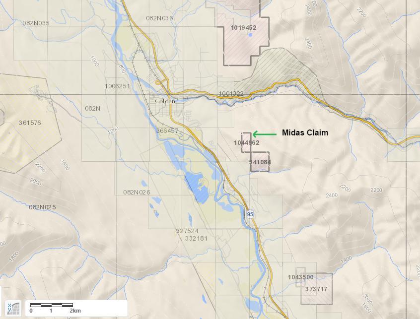
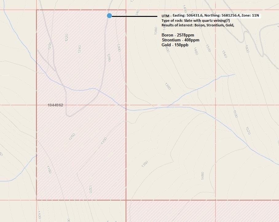
5 Introduction This prospecting report is based upon observations and assay results that were done on Midas. The claim is comprised of 2 cells, or hectares. Physical work was done on June 27 th 2016 and assay results were received July 20 th 2016 from Loring Labs in Calgary. This claim does not have a MINFILE to reference and the prior claim owner did not submit a technical report. There is a neighboring claim (Tenure#941084) that has an ARIS report (#03685). The purpose of this work was to see if any possible concentrations of minerals exist here. Location & Access The Midas claim is located a few kilometers east of Golden. To get here, take Highway 95 south of Golden and turn left on Bowie-Evans Drive. From there you will take a right on Bowie-Evans forestry service road and follow for a few kilometers until you arrive at the claim. This is a well maintained FSR. Summary & Conclusion On June 27 th, a brief prospecting program was carried out on the Midas claim in order to assess the area and collect a sample for assaying. A chip sample was taken and sent to Loring Labs for chemical analysis. Gold, Lithium, Rare Earth Elements and a 32 element ICP analysis were done to see what possible minerals could exist here. On July 20 th, assays results were received and tests show that Gold, Lithium, REE, and numerous other minerals were present (Assay results listed below). More work is required to assess if the assay grades are consistent throughout the claim. 3 P a g e
6 Geology The Geography on this claim is a quartzite of the Ordovician Wonah Formation. This type of rock is more resistant to erosion compared to the shale of the Glenogle Formation and Beaverfoot-Brisco Formation. The quartzite is a light grey colour with fine grained bands. Due to the amount of weathering and close proximity to a well maintained road, this material could technically be quarried and refined from its location. Work Date June 27 th 2016 Summary of Exploration Expenditures Labourer(1 Hour).. $35.00 Meals. $23.10 Gas.. $10.00 Lodging. $ Geochemical Assay Testing $ Total $ Qualifications for Giacomo Grassi - Graduate Gemologist (GIA: Diamonds & Gemstones) / 4 Years - Hard Rock Prospecting / 3 Years - Placer Prospecting / 3 Years Giacomo Grassi FMC# P a g e
7 LORING LABORATORIES LTD. 629 Beaverdam Rd NE. Calgary, AB T2K 4W7 +1 (403) To whom it may concern, We are the analytical laboratory that initially performed the lithium assays for Mr. Giacomo Grassi for the ARIS reports #36158, #36170, and #36163, as well as for Event # It has been brought to our attention recently that the lithium concentration data in those displayed a wide range of variations. Since then, both the management and the technical team carried out thorough internal investigations. It was found that an incorrect wavelength for our ICP-OES was used in determining the Lithium concentration of the samples in question. Resulting in elevated apparent lithium concentrations due to matrix interference. We re-assayed the samples with this possible issue employing an internal sample standard of a known concentration of Lithium and pinpointed the correct wavelength at which a new set of Lithium concentration data was determined. The new set of data is believed to reflect the subsurface concentration better, and we would like to file for an official change in data for the aforementioned reports. A copy of the original reported numbers and the new reassay values is attached to this letter for your reference (See Appended Table 1.). Kind regards, Adrien Banza, Laboratory Supervisor Loring Laboratories Ltd.
8 LORING LABORATORIES LTD. 629 Beaverdam Rd NE. Calgary, AB T2K 4W7 +1 (403) Table 1: Initial Reported Result Vs. Re-Assay Results for GIACOMO GRASSI Reference Number Sample Initial Reported Result Number (ppm) Re-Assay Results(ppm) ARIS ARIS ARIS EVENT #
9 Gold & Lithium Assay Results 5 P a g e
10 REE Assay Results 6 P a g e
11 32 Element Assay Results 7 P a g e
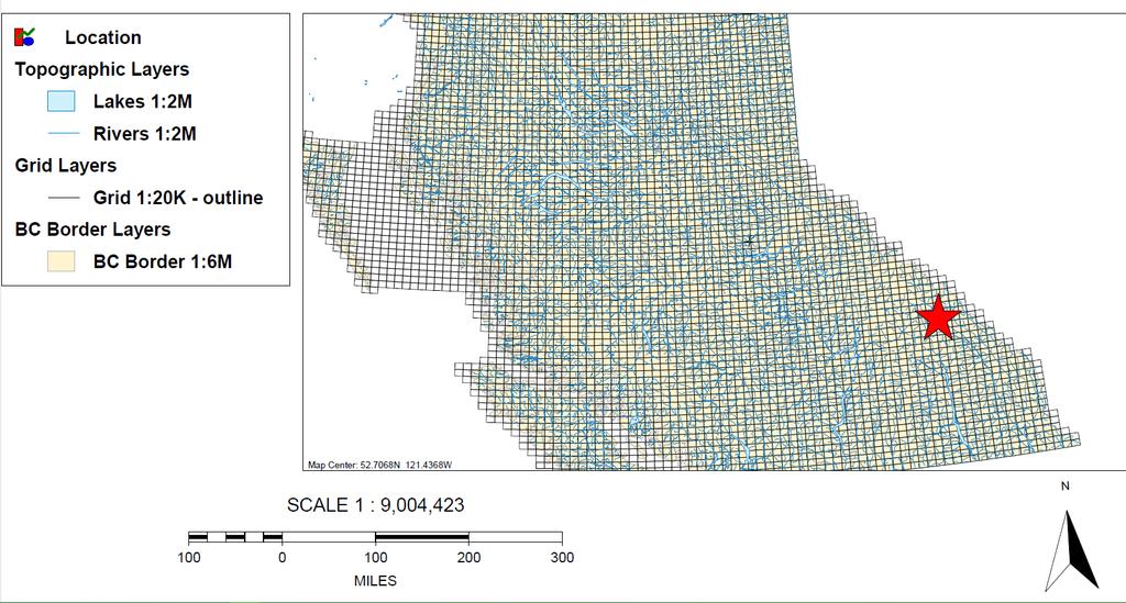
12 Geographical Location 8 P a g e
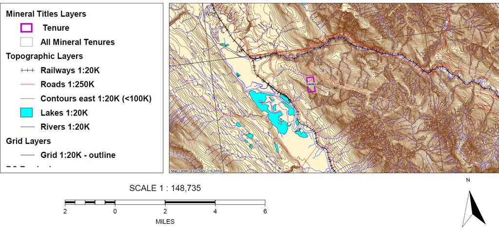
13 Topographic Map & Work Area 9 Page

14 Midas Geology 10 P a g e


15 Chip Sample Sample Area Picture 11 P a g e
ASSESSMENT REPORT TITLE PAGE AND SUMMARY
 ASSESSMENT REPORT TITLE PAGE AND SUMMARY TITLE OF REPORT: 2016 Prospecting Report Sphynx Claim TOTAL COST: $167.56 AUTHOR(S): Giacomo Grassi SIGNATURE(S): NOTICE OF WORK PERMIT NUMBER(S)/DATE(S): STATEMENT
ASSESSMENT REPORT TITLE PAGE AND SUMMARY
 ASSESSMENT REPORT TITLE PAGE AND SUMMARY TITLE OF REPORT: 2016 Prospecting Report Mystery Beryl TOTAL COST: $1299.09 AUTHOR(S): Giacomo Grassi SIGNATURE(S): NOTICE OF WORK PERMIT NUMBER(S)/DATE(S): STATEMENT
ASSESSMENT REPORT TITLE PAGE AND SUMMARY
 ASSESSMENT REPORT TITLE PAGE AND SUMMARY TITLE OF REPORT: Assessment Report on Andys Bridge Mineral Claim, Turnagain River Area TOTAL COST: $2,100 AUTHOR(S): Bruce w Downing SIGNATURE(S): Bruce W Downing
VICTORIA, BC FILE NO,
 FILE NO, VICTORIA, BC DEC - 7 2006 BFUTISH COLUMBIA Ministry of Energy & Mines Energy & Minerals Division Geological Survey Branch ASSESSMENT REPORT TITLE PAGE AND SUMMARY TITLE OF REPORT [type of survey(s)]
CONTENTS. Location, Access and History...6. Tenure Status and Geology Regional Andy Property Geology Map...9
 TYPE OFWORK IN THIS REPORT EXTENT OF WORK (rn METRTC UNITS) ON WHICH CLAIMS PROJECT COSTS APPORTIONED (incl. support) GEOLOGICAL (scale, area) Ground, mapping Photo interpretation GEOPHYSICAL (line-kilometres)
HDN MINERAL PRO iperty
 HDN MINERAL PRO iperty ROCK SAMPLE GEOCHEMISTRY ASSESSMENT REPORT 2010 OMINECA MINING DIVISION, BRITISH COLUMBIA 93L047 LATITUDE: 54 29' 16.9" N LONGITUDE: 126 39' 39.8" W GPS: NAD 83 UTM ZONE 9 NORTHING:
SIXTH SCHEDULE REPUBLIC OF SOUTH SUDAN MINISTRY OF PETROLEUM, MINING THE MINING (MINERAL TITLE) REGULATIONS 2015
 REGULATIONS 2015") SIXTH SCHEDULE REPUBLIC OF SOUTH SUDAN MINISTRY OF PETROLEUM, MINING THE MINING ACT, 2012 THE MINING (MINERAL TITLE) REGULATIONS 2015 Guidelines should be prepared by the Directorate of Mineral Development
SIXTH SCHEDULE REPUBLIC OF SOUTH SUDAN MINISTRY OF PETROLEUM, MINING THE MINING ACT, 2012 THE MINING (MINERAL TITLE) REGULATIONS 2015 Guidelines should be prepared by the Directorate of Mineral Development
ASSESSMENT REPORT TITLE PAGE AND SUMMARY
 ASSESSMENT REPORT TITLE PAGE AND SUMMARY TITLE OF REPORT: Assessment Report on Big Dean Mineral Claim, Turnagain River Area TOTAL COST: $9,164 AUTHOR(S): Bruce w Downing SIGNATURE(S): Bruce W Downing NOTICE
2013 GEOLOGICAL ASSESSMENT REPORT SHERIDAN HILL PROPERTY
 2013 GEOLOGICAL ASSESSMENT REPORT ON THE SHERIDAN HILL PROPERTY NEW WESTMINSTER MINING DIVISION BRITISH COLUMBIA NTS 092G07 49 16 31 NORTH LATITUDE, 122 39 48 WEST LONGITUDE PREPARED FOR Sheridan Hill
ASSESSMENT REPORT ON THE PEAVINE PROJECT. DGW & Associates # Alberni Street, Vancouver, British Columbia, V6E 4V2
 ASSESSMENT REPORT ON THE PEAVINE PROJECT KAMLOOPS MINING DIVISION BRITISH COLUMBIA NTS 082M 12 Latitude 51 36' 19.0"North -- Longitude --119 47' 27.0"West UTM Zone 11, NAD 83 5720827N 306744E Prepared
Prospecting Report on the Dynasty Jade Placer Dorthy Creek Claims
 Prospecting Report on the Dynasty Jade Placer Dorthy Creek Claims Claims 550004, 541288, 547670 Mining Division - Liard NTS or BCGS location 104J080 Latitude and longitude of geographic centre of work
O ITHIS )WE OF WORK IN I EXTENT OF WORK I I PROJECT COSTS I ON WHICH CLAIMS (IN METRIC UNITS) APPORTIONED (id. support) GEOLOGICAL (scale, area)
WE OF WORK IN I EXTENT OF WORK I I PROJECT COSTS I ON WHICH CLAIMS (IN METRIC UNITS) APPORTIONED (id. support) GEOLOGICAL (scale, area)") Geological Survey Branch TITLE OF REPORT [type of SUNOY(S)] TOTAL COST 1 MINERAL INVENTORY M OWNER@) MAILING ADDRESS -.,-- a 5 -a OPERATOR(S) [who paid ffo the wnk) 2) MAILING ADDRESS 76e2 HWY 97/gm LP
Geological Survey Branch TITLE OF REPORT [type of SUNOY(S)] TOTAL COST 1 MINERAL INVENTORY M OWNER@) MAILING ADDRESS -.,-- a 5 -a OPERATOR(S) [who paid ffo the wnk) 2) MAILING ADDRESS 76e2 HWY 97/gm LP
Prospecting Report Grandpa Claim Group
 2010 2011 Prospecting Report Grandpa Claim Group TENURE NUMBER: 705523 EVENT NUMBER: 4825383 TENURE NAME: GRANDPA Lillooet Mining Division Map 092I Central Coordinate Reference 50 57 30 N Latitude 121
ASSESSMENT REPORT TITLE PAGE AND SUMMARY
 ASSESSMENT REPORT TITLE PAGE AND SUMMARY TITLE OF REPORT: Assessment Report on The Plateau Mineral Claim, Turnagain River Area TOTAL COST: $11,026 AUTHOR(S): Bruce w Downing SIGNATURE(S): Bruce W Downing
DEVELOPMENT REPORT. Lone I Mineral Claim Group. Wild Horse River Area Cranbrook, B.C.
 DEVELOPMENT REPORT Lone I Mineral Claim Group Wild Horse River Area Cranbrook, B.C. Fort Steele Mining District NTS 82G/12E 49 38 35 Latitude 115 38 00 Longitude LONE PEAK PLACER LTD. 514-13th Avenue South
Date Submitted: June General Nature of Report: Examination of Placer Samples
 General Nature of Report: Examination of Placer Samples Claim: Gold Channel, Record Number 3775!8 1 (Gold Channel Placer Property) Mining Division: Cariboo NTS 093 G 09 W and E Latitude 520 23 N' Longitude1210
NTS 082F03SW N W U E N
 Prospecting Report JOCELYN CLAIM NTS 082F03SW N49 09 51 W 117 14 04 11U 482906E 5445737N NELSON MINING DIVISION Martin Ross PO Box 323 Salmo BC V0G 1Z0 Jan 31, 2012 PROSPECTING REPORT JOCELYN MINERAL CLAIM
PROSPECTING REPORT. Karen Creek. EVENT # TENURE # Tenure Name: Karen Creek. New Westminster Mining Division Map 092H
 2008-2009 PROSPECTING REPORT Karen Creek EVENT # 4269354 TENURE # 578618 Tenure Name: Karen Creek New Westminster Mining Division Map 092H Central Coordinate Reference 121 17 30.7 W Longitude 49 26 21.9
, , ,
 Ministry of Energy and Mines BC Geological Survey Assessment Report Title Page and Summary TYPE OF REPORT [type of survey(s)]: Airborne Geophysic TOTAL COST: 9,4. AUTHOR(S): Walcott, A. Walcott, P SIGNATURE(S):
PROSPECTING REPORT. Deneau Creek. EVENT # TENURE # Tenure Name: Deneau Creek. New Westminster Mining Division Map 092H
 2010-2011 PROSPECTING REPORT Deneau Creek EVENT # 4844921 TENURE # 578616 Tenure Name: Deneau Creek New Westminster Mining Division Map 092H Central Coordinate Reference 121 18 04.5 W Longitude 49 26 13.9
GEOLOGICAL MAPPING REPORT ON THE ASH MINERAL CLAIM OSOYOOS MINING DIVISION ASHNOLA RIVER MAP SHEET NTS M092,H019 MCBRIDE CREEK AREA, ASHNOLA RIVER,
 GEOLOGICAL MAPPING REPORT ON THE ASH MINERAL CLAIM OSOYOOS MINING DIVISION ASHNOLA RIVER MAP SHEET NTS M092,H019 LATITUDE 49 o O6, LONGITUDE 120 o 22 MCBRIDE CREEK AREA, ASHNOLA RIVER, KEREMEOS, B.C. CANADA
Prospecting Report on the Dynasty Jade Claims
 Prospecting Report on the Dynasty Jade Claims Claims 519762, 520237, 520336 Mining Division - Liard NTS or BCGS location 104J080 Latitude and longitude of geographic centre of work 58.78 N 130.08 W Owner
, ,
 Ministry of Energy, Mines & Petroleum Resources Mining & Minerals Division BC Geological Survey Assessment Report Title Page and Summary TYPE OF REPORT [type of survey(s)]: Airborne Magnetic Survey TOTAL
PROSPECTING REPORT. Broken Hill Property. EVENT # TENURE # Tenure Name: Broken Hill. New Westminster Mining Division Map 092H
 2009-2010 PROSPECTING REPORT Broken Hill Property EVENT # 4514071 TENURE # 600988 Tenure Name: Broken Hill New Westminster Mining Division Map 092H Central Coordinate Reference 121 24 26.2 W Longitude
Technical Standards for Reporting Assessment Work Under the Provisions of the Mining Act R.S.O. 1990
 Technical Standards for Reporting Assessment Work Under the Provisions of the Mining Act R.S.O. 1990 March 5, 2018 CONTENTS INTRODUCTION WORK TYPES AND ASSOCIATED WORK TYPES 1. GRASS ROOTS PROSPECTING
GEOLOGICAL BRANCH ASSESSMENT REPORT 12. FItE NO: ACTION: THE GOLDEN MINING DIVISION, GOLDEN, Including THE NTS MAP; M82K/15W
 ACTION: FItE NO: Including 1990 GEO-CHEM SURVEY RESULTS -- THE AVD CLAIMS - THE GOLDEN MINING DIVISION, GOLDEN, B.C. NTS MAP; M82K/15W Lat. 50 deg. 55 Min. Long 116 deg. 55 min. For GEOLOGICAL BRANCH ASSESSMENT
DÉCOUVERTE Positioned for Discovery in James Bay, Quebec. Investor Presentation, January 2018 by Danae Voormeij, MSc, PGeo
 DÉCOUVERTE Positioned for Discovery in James Bay, Quebec Investor Presentation, January 2018 by Danae Voormeij, MSc, PGeo Location Maps and Infrastructure Location: Durango Resources 100% owned Découverte
NOTICE OF WORK PERMIT NUMBER(S)/DATE(S):
/DATE(S):") Ministry of Energy and Mines BC Geological Survey Assessment Report Title Page and Summary TYPE OF REPORT [type of survey(s)]: Technical Reporting (mineral claim) TOTAL COST: $2,200.00 AUTHOR(S): Craig
Ministry of Energy and Mines BC Geological Survey Assessment Report Title Page and Summary TYPE OF REPORT [type of survey(s)]: Technical Reporting (mineral claim) TOTAL COST: $2,200.00 AUTHOR(S): Craig
RECONNAISSANCE GEOCHEMICAL SURVEY
 RECONNAISSANCE GEOCHEMICAL SURVEY LEGAL, RITA, LOUISE FR. (CHAPLEAU GROUP) REVERTED CROWN GRANTS CHAPLEAU CREEK AREAJ, SLOC& MINING DIVISION 82 F/11W Lat: 49'44" Long: 117"22'W MINERAL RESOURCES BRANCH
Ronin Placer Ground-penetrating Radar Survey Report
 Ronin Placer Ground-penetrating Radar Survey Report Tenures: 837095, 837097 Mining Division: Greenwood NTS Location: 082E/03 Geographic Center Coordinates: UTM Zone 11, E 345340, N 5438730 Claims Owner:
ASSESSMENT REPORT TITLE PAGE AND SUMMARY
 ASSESSMENT REPORT TITLE PAGE AND SUMMARY TITLE OF REPORT: Assessment Report on An Induced Polarization, Lac La Hache, in the Lac La Hache area, westcentral British Columbia Clinton Mining Division TOTAL
Airborne Geophysical TOTAL COST: $8, ,
 Ministry of Energy, Mines & Petroleum Resources Mining & Minerals Division BC Geological Survey Assessment Report Title Page and Summary TYPE OF REPORT [type of survey(s)]: Airborne Geophysical TOTAL COST:
For personal use only
 ABN 79 106 879 690 7 October 2011 The Manager Companies ASX Limited 20 Bridge Street SYDNEY NSW 2000 (6 pages by email) Dear Madam, Multiple zones intersected including 123 metres at 0.61 g/t Gold and
SECOND and THIRD YEAR ASSESSMENT REPORT PROSPECTING LICENCE M, ROCK CUT PROPERTY, NTS 1N/12, NEWFOUNDLAND. ROY FRENCH (licence holder )
") SECOND and THIRD YEAR ASSESSMENT REPORT Of PROSPECTING On LICENCE 013704M, ROCK CUT PROPERTY, NTS 1N/12, NEWFOUNDLAND. By ROY FRENCH (licence holder ) Work Conducted: Sept. 17, 2008 Nov. 03, 2009 Total
SECOND and THIRD YEAR ASSESSMENT REPORT Of PROSPECTING On LICENCE 013704M, ROCK CUT PROPERTY, NTS 1N/12, NEWFOUNDLAND. By ROY FRENCH (licence holder ) Work Conducted: Sept. 17, 2008 Nov. 03, 2009 Total
Goldsource Coal Intercepts in Saskatchewan
 Goldsource Coal Intercepts in Saskatchewan For Immediate Release VANCOUVER, B.C. April 28, 2008 Goldsource Mines Inc. (the Company ) wishes to make the following statements regarding the intercepts of
Report of Gridding and Magnetic Surveys. On the. Munro Property. Munro and Beatty Townships, Ontario. Larder Lake Mining Division
 Report of Gridding and Magnetic Surveys On the Munro Property Munro and Beatty Townships, Ontario Larder Lake Mining Division Claims: 39 4244 For Big Red Diamond Corporation October 3, 2 Timmins, Ontario
Frederick Cook Digitally signed by Frederick Cook
 Ministry of Energy and Mines BC Geological Survey Assessment Report Title Page and Summary TYPE OF REPORT [type of survey(s)]: Analyses of Geophysical Data: Big Kahuna Property TOTAL COST: $6,400 AUTHOR(S):
A GUIDE TO WRITING AN ASSESSMENT REPORT ON YOUR CLAIMS
 A GUIDE TO WRITING AN ASSESSMENT REPORT ON YOUR CLAIMS PLEASE NOTE! In the following pages, suggestions and advice are in italics, under each heading. Use as a guideline only. Items in bold should be changed
4J)SESSMEN'I' REPORT BRANCH. cc" FILE No: ASSESSMENT REPORT VICTORIA MINING DIVISION. Latitude 123O SF' Longitude 48O S5'
SESSMEN'I' REPORT BRANCH. cc FILE No: ASSESSMENT REPORT VICTORIA MINING DIVISION. Latitude 123O SF' Longitude 48O S5'") ASSESSMENT REPORT - ON THE ORM 1 MINERAL CLAIM VICTORIA MINING DIVISION NTS 92B cc" Latitude 123O SF' Longitude 48O S5' 3-2. w N C FILE No: @&@LOGI.CAL BRANCH 4J)SESSMEN'I' REPORT Date : June 1, 1990 TABLE
ASSESSMENT REPORT - ON THE ORM 1 MINERAL CLAIM VICTORIA MINING DIVISION NTS 92B cc" Latitude 123O SF' Longitude 48O S5' 3-2. w N C FILE No: @&@LOGI.CAL BRANCH 4J)SESSMEN'I' REPORT Date : June 1, 1990 TABLE
/ *t** /, NOTTCE OF WORK PERMIT NUMBER(S)/DATE(S): STATEMENT OF WORK EVENT NUMBER(SXDATE(S ): , Oct 4, 2009
/DATE(S): STATEMENT OF WORK EVENT NUMBER(SXDATE(S ): , Oct 4, 2009") TOTAL COST: $3,499.5{ ASSESSMENT REPORT TITLE PAGE AND ST}MMARY TITLE OF REPORT: Geochemical Survey on the READIMIX Property AUTHOR(S) : Gordorl Richards srcnarune(s): / *t** /, NOTTCE OF WORK PERMIT NUMBER(S)/DATE(S):
TOTAL COST: $3,499.5{ ASSESSMENT REPORT TITLE PAGE AND ST}MMARY TITLE OF REPORT: Geochemical Survey on the READIMIX Property AUTHOR(S) : Gordorl Richards srcnarune(s): / *t** /, NOTTCE OF WORK PERMIT NUMBER(S)/DATE(S):
Ronin and Dayton Placer Ground-penetrating Radar Survey Report
 Ronin and Dayton Placer Ground-penetrating Radar Survey Report Tenures: 837095, 837097, 889865, 890187 Mining Division: Greenwood NTS Location: 082E/03 Geographic Center Coordinates: UTM Zone 11, E 345340,
Guidelines for the Form of Reports and Illustrations
 Guidelines for the Form of Reports and Illustrations as Prescribed by the Minister as per Section 55(2) of The Consolidated Newfoundland and Labrador Regulation 1143/96 (As Amended) (Revised - December,
CERRO PRIETO PROJECT MINERAL CONCESSIONS LOCATION AND ACCESS
 Cerro Prieto CERRO PRIETO PROJECT MINERAL CONCESSIONS The Cerro Prieto Project is comprised of three mining exploitation concessions encompassing 2,723 hectares in northern Sonora, Mexico. Oroco holds
Simplified exploration work report
 Simplified exploration work report Work Report of exploration and examination of outcrops of rock and boulders Report on stripping and excavating work of $ 5 000 or less.(section 81 of regulation) Report
OWNER OPERATOR: BLACKWATER EXPLORATIONS LTD. REPORT ON SEISMIC REFRACTION SURVEY PLACER GOLD EXPLORATION
 OWNER OPERATOR: BLACKWATER EXPLORATIONS LTD. REPORT ON SEISMIC REFRACTION SURVEY PLACER GOLD EXPLORATION CARIBOO MINING DISTRICT NTS 93G CLAIM PC682023 Latitude 53 13 35.64 Longitude 122 49 40.65 by Russell
ASX Announcement. 28 January Drill results indicate large Porphyry Copper Gold System at Peenam
 ASX Announcement 28 January 2010 Drill results indicate large Porphyry Copper Gold System at Peenam Highlights: 270 metres of visible copper (gold) mineralisation in first diamond core hole at Peenam Prospect
We are committed to providing accessible customer service. If you need accessible formats or communications supports, please contact us.
 We are committed to providing accessible customer service. If you need accessible formats or communications supports, please contact us. Nous tenons à améliorer l accessibilité des services à la clientèle.
Jedway Enterprises Ltd st Ave, Surrey, BC V3S 3M3
 Jedway Enterprises Ltd. 104-19286 21 st Ave, Surrey, BC V3S 3M3 Prospecting Report on the Den (Den#1 to #4) Property, Takla Landing Area, Omineca Mining Division, British Columbia NTS 93N/12 Trim 093N052,093N062
PROSPECTING REPORT. Silver Dollar Property. EVENT # TENURE # Tenure Name: GPEX Silver Dollar
 2008-2009 PROSPECTING REPORT Silver Dollar Property EVENT # 4267989 TENURE # 555462 Tenure Name: GPEX Silver Dollar Similkameen Mining Division Map 092H Central Coordinate Reference 120 06 26.9 W Longitude
REPORT OF PHYSICAL EXPLORATION AND DEVELOPMENT Section 15 - Mineral Tenure Act Regulation
 1. EVENT NUMBER(S) 1234567 4. RECORDED HOLDER Doe 123 Main Street REPORT OF PHYSICAL EXPLORATION AND DEVELOPMENT Section 15 - Mineral Tenure Act Regulation Mineral Titles and Policy Branch Ministry of
PROSPECTING REPORT. Medallion Property. EVENT # TENURE # Tenure Name: GPEX CLVIII Medallion
 2006-2007 PROSPECTING REPORT Medallion Property EVENT # 4167980 TENURE # 540362 Tenure Name: GPEX CLVIII Medallion Watson Bar Region Clinton Mining Division Map 092O Central Coordinate Reference Long.
1 FILMED 1. FILE NO:!..rsrru -* -. GRAND TWO CLAIM
 FILE NO:!..rsrru -* -. GRAND TWO CLAIM REPORT ON 1993 ASSESSMENT WORK GRAND TWO CLAIM REC. NO. 301849 NELSON MINING DIVISION NTS MAP SHEET 82F6/W 49 25'51" NORTH 117 18'08" WEST 1 FILMED 1 AUTHOR: R. Jordan,
ROCK GEOCHEMISTRY REPORT KRL PROPERTY FT STEELE MINING DIVISION TEEPEE CREEK AREA SOUTHEAST BC WORK PERFORMED SUMMER 2010
 ROCK GEOCHEMISTRY REPORT KRL PROPERTY FT STEELE MINING DIVISION TEEPEE CREEK AREA SOUTHEAST BC WORK PERFORMED SUMMER 2010 ft o fee ft c«ft S2 > 2 r H OWNER: DARLENE LAVOIE, SARAH KENNEDY OPERATOR: KOOTENAY
ASSESSMENT REPORT TITLE PAGE AND SUMMARY
 ASSESSMENT REPORT TITLE PAGE AND SUMMARY TITLE OF REPORT: Diamond Drilling Report on the Jacobie Lake Copper Prospect TOTAL COST: $83,692 AUTHOR(S): P. E. Fox PhD P.Eng SIGNATURE(S): NOTICE OF WORK PERMIT
1 CLAIMS GEOPHYSICAL REPORT ON BOYAL SITUATE NORTHEAST OF TILLICUM MOUNTAIN GOLD AREA BURTON - NAKUSP SIQCAEJ MINING DIVISION
 GEOPHYSICAL REPORT ON BOYAL 1 CLAIMS SITUATE NORTHEAST OF TILLICUM MOUNTAIN GOLD AREA BURTON - NAKUSP SIQCAEJ MINING DIVISION CONSULTING GEOLOGIST AUGUST 1983 VANCOUVER B *C INDEX INTRODUCTION ooa,.eoaaa.aaaoaaooaoa~ao~o
Drilling Program Commences on Iron Oxide Copper Gold Targets
 3 June 2008 Manager Company Announcements Company Announcements Office Australian Stock Exchange Limited Level 10, 20 Bond Street SYDNEY NSW 2000 ABN 42 082 593 235 Electronic delivery No of pages: 6 Drilling
ENCOURAGING GOLD-BASE METALS AT MAY DAY, MOLY- GOLD AT ATTUNGA
 ASX / MEDIA RELEASE 5 JULY 2010 ENCOURAGING GOLD-BASE METALS AT MAY DAY, MOLY- GOLD AT ATTUNGA Peel Exploration is pleased to announce that recent drilling at the Company s Attunga and May Day projects
DISCOVERY OF MINERALISED PORPHYRY & MAGNETITE-COPPER-GOLD AT KAMARANGAN
 MEDUSA MINING LIMITED ABN: 60 099 377 849 Unit 7, 11 Preston Street Como WA 6152 PO Box 860 Canning Bridge WA 6153 Telephone: +618-9367 0601 Facsimile: +618-9367 0602 Email: admin@medusamining.com.au Internet:
SUMBA EXPLORATION UPDATE
 ASX RELEASE Tuesday, 23 November 2010 SUMBA EXPLORATION UPDATE Hillgrove Resources Limited (ASX:HGO) today announces a planned airborne geophysical survey, Pelitalira prospect progress and final results
Table of Contents. Title Page and Summary
 1 2 Table of Contents Page 1&2 Title Page and Summary Page 3 Table of Contents Page 4 Cover Page Page 5 Summary and Introduction Page 6 Location/Location Map Page 7 Claim Location Map Page 8 Claim Status/Property
NOTICE OF WORK PERMIT NUMBER(S)/DATE(S):
/DATE(S):") Ministry of Energy and Mines BC Geological Survey Assessment Report Title Page and Summary TYPE OF REPORT [type of survey(s)]: Prospecting, geochemical TOTAL COST: 2,267.74 AUTHOR(S): Milosz Mielniczuk
Ministry of Energy and Mines BC Geological Survey Assessment Report Title Page and Summary TYPE OF REPORT [type of survey(s)]: Prospecting, geochemical TOTAL COST: 2,267.74 AUTHOR(S): Milosz Mielniczuk
RELINQUISHMENT REPORT 8309/1-11 (ÄKÄS 1-11) by Tiia Kivisaari
 by Tiia Kivisaari") RELINQUISHMENT REPORT 8309/1-11 (ÄKÄS 1-11) by Tiia Kivisaari Northland Mines Oy Asematie 4, 95900 KOLARI August 2014 6.8.2014 RELINQUISHMENT REPORT DOCUMENTATION PAGE Kohteen nimi: Äkäsjokisuu Malminetsintäluvan
RELINQUISHMENT REPORT 8309/1-11 (ÄKÄS 1-11) by Tiia Kivisaari Northland Mines Oy Asematie 4, 95900 KOLARI August 2014 6.8.2014 RELINQUISHMENT REPORT DOCUMENTATION PAGE Kohteen nimi: Äkäsjokisuu Malminetsintäluvan
For personal use only
 10 July 2012 Encouraging New Gold Results from Gunung Rosa Drilling Highlights Assay results from three drill holes at depth under the Cap Palu section confirm significantly wider intercepts of gold-copper-base
PROSPECTING REPORT THE WALLACE CLAIM OMENICA MINING DIVISION. 54" x6" 3.d d. for. Reako Exlorat ions Ltd. Wallace Rev. C.G.
 PROSPECTING REPORT ON THE WALLACE CLAIM OMENICA MINING DIVISION 54"44 14 1x6" 3.d d by David A. Howard P.Eng. for Reako Exlorat ions Ltd. Claim Locat ion Wallace Rev. C.G. #1560 Dome Mountain Area 9 3
For personal use only
 21 December 2017 MASSIVE SULPHIDES INTERSECTED IN DRILLING 15 hole, 2270m diamond drill program completed at Midrim Thick zones of massive sulphides intersected Core being logged and sampled with assays
Goliath Reports Grams Per Tonne Gold Equivalent Over 2 Metres Channel Cut at Golddigger in the Golden Triangle; Bulk Sample Recommended
 Goliath Reports 22.83 Grams Per Tonne Gold Equivalent Over 2 Metres Channel Cut at Golddigger in the Golden Triangle; Bulk Sample Recommended November 28, 2017 Goliath Resources Ltd. (TSX-V: GOT) (the
POTENTIAL OF THE DONGWE COPPER GOLD PROJECT
 POTENTIAL OF THE DONGWE COPPER GOLD PROJECT By Nathan Sabao, P.Geo. September 2015 1 TABLE OF CONTENTS Page 1.0 EXECUTIVE SUMMARY 1 2.0 LOCATION 2 3.0 ACCESS 2 4.0 GEOLOGY 3 5.0 PREVIOUS DRILLING 5 6.0
Prospecting Report 'S Office i DB Property, B.C. -J Negro Creek Nelson Mining District NTS 82F.050. Operator: Kootenay Gold Inc.
 . '.' I"' i9 12 Prospecting Report 'S Office i DB Property, B.C. -J Negro Creek Nelson Mining District NTS 82F.050 Operator: Kootenay Gold Inc. Owner: Darlene Lavoie Work Performed Summer of 2007 Report
NEW COBAR-STYLE COPPER DISCOVERY IN NSW
 ASX / MEDIA RELEASE 2 AUGUST 2011 NEW COBAR-STYLE COPPER DISCOVERY IN NSW Broad zone of copper-polymetallic mineralisation intersected at 4-Mile prospect Highlights: Wide zone of copper-silver-gold-lead-zinc
SOIL GEOCHEMISTRY ENTERPRISE MINE NTS 82 F/14 W ARCTEX ENGINEERING SERVICES CONSULTANT, OWNER, OPERATOR, AUTHOR JANUARY, 1.981
 SOIL GEOCHEMISTRY ENTERPRISE MINE t SLOCAN MINING DIVISION, Bn C, NTS 82 F/14 W LATITUDE 49'49') LONGITUDE 1'19' ARCTEX ENGINEERING SERVICES I L, B, GOLDSMITH, PiENG, CONSULTANT, OWNER, OPERATOR, AUTHOR
EMORY PLACER CLAIM Yale Region New Westminster Mining Division
 EMORY PLACER CLAIM Yale Region New Westminster Mining Division EVENT # 4646011 TENURE # 608187 Tenure Name: Emory NTS Map 92H/11 Approximate Centre of Tenure 121 25 12 W Longitude 49 30 44 N Latitude Report
RECONNAISSANCE AND SOIL GEOCHEMICAL SAMPLING REPORT PORCUPINE MINING DIVISION ON CLAIM , LANGMUIR TOWNSHIP
 RECONNAISSANCE AND SOIL GEOCHEMICAL SAMPLING REPORT ON CLAIM 1224499, LANGMUIR TOWNSHIP PORCUPINE MINING DIVISION CLM 1224499 NTS: 42A/06 Author: William Randall, P.Geo 1 Table of Contents Work Performed
NT RESOURCES LIMITED QUARTERLY ACTIVITIES REPORT FOR THE PERIOD ENDED 30 JUNE 2010 ASX CODE: NTR
 NT RESOURCES LIMITED QUARTERLY ACTIVITIES REPORT FOR THE PERIOD ENDED 30 JUNE 2010 ASX CODE: NTR Activities Report Background NT Resources Limited ( NT Resources or the Company ) holds six granted Exploration
PROSPECTING REPORT TENURES # / / CLAIM NAMES OLD SETTLER; OLD SETTLER1; OLD SETTLER2
 2011 PROSPECTING REPORT EVENT - 5160426 TENURES # 688183 / 691903 / 691905 CLAIM NAMES OLD SETTLER; OLD SETTLER1; OLD SETTLER2 COAST CRYSTALINE BELT REGION NEW WESTMINSTER MINING DISTRICT MAP - 092H GPS
Reports Initial Assays of 0.69 g/t Au over 27 Metres including 1.09 g/t Au over 9 Metres
 Reports Initial Assays of 0.69 g/t Au over 27 Metres including 1.09 g/t Au over 9 Metres Guyana Goldstrike Inc. (GYA.V) reported more assay results from Trench TTR-18-7 at the Toucan Ridge area on its
TECHNICAL REPORT ON THE BLACK CREEK PROPERTY FOR CARRIE ARRAN RESOURCES BLACK TOWNSHIP LARDER LAKE MINING DIVISION ONTARIO
 TECHNICAL REPORT ON THE BLACK CREEK PROPERTY FOR CARRIE ARRAN RESOURCES BLACK TOWNSHIP LARDER LAKE MINING DIVISION ONTARIO B.J. McKay, 8 February 2011 Keewatin, Ontario TECHNICAL REPORT BJML 2011 Table
Drilling Commences at Telfer West Gold Project
 Level 7, 600 Murray Street West Perth WA 6005 PO Box 273 West Perth WA 6872 P 08 9486 9455 F 08 6210 1578 www.enrl.com.au 17 November 2016 ASX : ENR Company Announcements Office Australian Securities Exchange
PROSPECTING REPORT PLACER CLAIM - FOX 4 SIMILKAMEEN MINING DIVISION MAP - 092H GPS COORDINATE REFERENCE CENTER OF CLAIM ' 6"N, 120.
 2011 PROSPECTING REPORT PLACER CLAIM - FOX 4 TENURE #793322 EVENT #5160421 SIMILKAMEEN MINING DIVISION MAP - 092H GPS COORDINATE REFERENCE CENTER OF CLAIM 49. 24' 6"N, 120. 36* 30" W REPORT PREPARED BY
PROSPECTORS ASSISTANCE PROGRAM MINISTRY OF ENERGY AND MINES
 BRITISH COLUMBIA PROSPECTORS ASSISTANCE PROGRAM MINISTRY OF ENERGY AND MINES GEOLOGICAL SURVEY BRANCH PROGRAM YEAR: 1999/2000 REPORT #: PAP 99-l 6 NAME: KIM ANSCHETZ PROSPECTORS TlEPORT on the 99 LOUIS
PHYSICAL WORK REPORT ON THE. KINGDOMlwINERAL LILLOOET MINING DIVISION. NTS Map Sheet 92J/15W. Co-Ordinates North: East
 PHYSICAL WORK REPORT ON THE KINGDOMlwINERAL CLAIM LILLOOET MINING DIVISION NTS Map Sheet 92J/15W Co-Ordinates North: 50 48 East 120 48 For Assessment Work BY Edward Skoda October 15,2002 Vancouver, British
SUMMARY REPORT. RE-ESTABLISH CLAIM BOUNDARY (Claim ) CARR TOWNSHIP (Larder Lake Mining Division) NTS (42 Al09) FOR
 CARR TOWNSHIP (Larder Lake Mining Division) NTS (42 Al09) FOR") 2.44330 " SUMMARY REPORT RE-ESTABLISH CLAIM BOUNDARY (Claim 3002288) CARR TOWNSHIP (Larder Lake Mining Division) NTS (42 Al09) FOR ST ANDREW GOLDFIELDS LTD. ""'1,.I Les 1. Kovacs, P. Geo For: St Andrew
2.44330 " SUMMARY REPORT RE-ESTABLISH CLAIM BOUNDARY (Claim 3002288) CARR TOWNSHIP (Larder Lake Mining Division) NTS (42 Al09) FOR ST ANDREW GOLDFIELDS LTD. ""'1,.I Les 1. Kovacs, P. Geo For: St Andrew
..!I AXE CLAIMS ON THE. for RICHCORE EXPLORATIONS LTO. GREENWOOD MINING DIVISION BRITISH COLUMBIA. Latitude 49O 30"; Longitude 118' 30'W NTS 82E/9W
 ON THE AXE CLAIMS for RICHCORE EXPLORATIONS LTO. GREENWOOD MINING DIVISION BRITISH COLUMBIA Latitude 49O 30"; Longitude 118' 30'W NTS 82E/9W... -... ~ i.,...._.'..!i Vancouver, B.C. September, 1980 P.
PHYSICAL WORK REPORT. the BAY CLAIMS. Omineca Mining Division Smithers, British Columbia N.T.S. 93E 13E/W
 PHYSICAL WORK REPORT the BAY CLAIMS Omineca Mining Division Smithers, British Columbia a N.T.S. 93E 13E/W LATITUDE: 53 57 00 N I LONGITUDE: 127 45 OO W for Home Ventures Ltd. 1201-675 West Hastings Street
TRENCHING AT LAS DOLORES EXTENDS STRIKE LENGTH TO OVER 1,000 METRES, INTERSECTING
 January 31, 2018 NEWS RELEASE - #18-03 TSX- V: GRR Suite 501-595 Howe Street Vancouver, BC V6C 2T5 Tel: (604) 685-4655 Fax: (604) 685-4675 Toll Free: 1-888-685-4655 TRENCHING AT LAS DOLORES EXTENDS STRIKE
GEOLOGICAL SURVEY BRANCH ASSESSMENT REPORT GEOLOGICAL REPORT. on the ELM PROPERTY-TENURE # KAMLOOPS M.D. NTS 921/15W 2012/08/26 J.D.
 GEOLOGICAL REPORT on the ELM PROPERTY-TENURE #508266 KAMLOOPS M.D. NTS 921/15W LA T 50-58 N LONG 120-52 W by J.D.MURPHY OWNER AND OPERATOR 2012/08/26 GEOLOGICAL SURVEY BRANCH ASSESSMENT REPORT TABLE OF
on the Diamond Drilling done on the LAKESIOE GROUP of Mineral Claims SLOCAN MINING DIVISION 82-F-14-W Long ' Lat '
 Assessment Work Report on the Diamond Drilling done on the LAKESIOE GROUP of Mineral Claims SLOCAN MINING DIVISION 82-F-14-W Long 117 22' Lat. 49 58' ADRIAN KESLER SILVERTON, B.C. operator LEVON RESOURCES
National Instrument Technical Report
 National Instrument 43-101Technical Report Pigeon River Property Hartington Township Ontario, Canada Thunder Bay Mining Division, NTS 42A4 Geology Updated Technical Report UTM: Zone 16, 277134m E, 5332229m
Field Geologists' Manual. AuslfTlfT) Monograph 9 FIFTH EDITION THG MINERALS INSTITUTE. Published by:
 Monograph 9 FIFTH EDITION THG MINERALS INSTITUTE. Published by:") Field Geologists' Manual FIFTH EDITION Monograph 9 AuslfTlfT) THG MINERALS INSTITUTE Published by: THE AUSTRALASIAN INSTITUTE OF MINING AND METALLURGY Ground Floor, 204 Lygon Street, Carlton Victoria 3053
Field Geologists' Manual FIFTH EDITION Monograph 9 AuslfTlfT) THG MINERALS INSTITUTE Published by: THE AUSTRALASIAN INSTITUTE OF MINING AND METALLURGY Ground Floor, 204 Lygon Street, Carlton Victoria 3053
NEWS RELEASE ORCA GOLD REPORTS CONTINUED SUCCESS AT GSS
 NEWS RELEASE OA GOLD REPORTS CONTINUED SUCCESS AT GSS May 26, 2014 Orca Gold Inc. (TSX.V:ORG) ( Orca or the Company ) is pleased to provide an update on exploration at its Galat Sufar South ( GSS ) prospect
Rare Earth project update
 22 June 2011 ASX Release By e-lodgement Rare Earth project update HIGHLIGHTS Work advanced on Rare Earth Elements ( REE ) project in Arizona, USA 5,120 metre, 195 hole drilling programme completed Early
Advancing High Grade Gold Assets in Red Lake, Ontario
 Advancing High Grade Gold Assets in Red Lake, Ontario Forward Looking Statement Except for historical information contained herein, this presentation may contain forward-looking statements including but
NEWS RELEASE Ocean Park Ventures Identifies Large Multi-Structure Sulfide Mineralized System Trapper Gold Project, British Columbia
 Suite 302 750 West Pender St Vancouver, BC V6C 2T7 Tel: 604-681-0084 Fax: 604-681-0094 www.oceanparkventures.com TSX-V SYMBOL: OCP NEWS RELEASE Ocean Park Ventures Identifies Large Multi-Structure Sulfide
Geochemical and Prospecting Report on the. Lanark Property LIBERTY INTERNATIONAL MINERAL CORPORATION CLAIMS
 Geochemical and Prospecting Report on the Lanark Property LIBERTY INTERNATIONAL MINERAL CORPORATION CLAIMS NELSON/REVELSTOKE MINING DIVISION BRITISH COLUMBIA LATITUDE N51*13, LONGITUDE W117*44 UTM 448841E/
Quaternary clays alluvial sands of the Shepparton Formation overlie the basement rocks.
 NAGAMBIE GOLDFIELD Regional Geological Setting The Nagambie Project is located within the Melbourne Structural Zone of Victoria. The lithologies range in age from the Upper Silurian Broadford Formation
Eloro Outlines Major New Mineralized Trend on La Victoria Project, Peru; Sample Results Return Values To 33 Grams Gold Per Tonne
 20 Adelaide Street East, Suite 200, Toronto, Ontario CANADA M5C 2T6 Tel.: (416) 868-9168 Fax: (416) 361-1333 TSX.V Symbol: ELO www.elororesources.com Eloro Outlines Major New Mineralized Trend on La Victoria
******************* *******************
 This announcement lifts the trading halt requested by the Company on the 13 September 2012 Announcement to the Australian Securities Exchange Monday 17 September 2012 COMPANY UPDATE PARTIALLY UNDERWRITTEN
For personal use only
 22 April 2013 Drilling to commence at Majada, Copper-Gold Prospect, Chile. Red Gum Resources Limited (ASX: RGX, Red Gum or the Company ) is pleased to announce that drilling of its Majada Copper-Gold Prospect,
For personal use only
 ANNOUNCEMENT TO THE AUSTRALIAN SECURITIES EXCHANGE: 28 NOVEMBER 2012 DRILLING UPDATE MABILO PROJECT The Directors of Sierra Mining Limited ( Sierra ) are pleased to announce further results from reconnaissance
ASSESSMENT REPORT GEOLOGICAL BRANCH. 50' 23 'North. GEOLOGICAL and GEOCHEMICAL SURVEYS ON THE. PUTNAM PROPERTY (Putnam Mineral Claim)
") GEOLOGICAL and GEOCHEMICAL SURVEYS ON THE PUTNAM PROPERTY (Putnam Mineral Claim) VERNON MINING DIVISION, B.C. GEOLOGICAL BRANCH ASSESSMENT REPORT NTS : Latitude: 82L17W 50' 23 'North LOCATION, ACCESS,
GEOLOGICAL and GEOCHEMICAL SURVEYS ON THE PUTNAM PROPERTY (Putnam Mineral Claim) VERNON MINING DIVISION, B.C. GEOLOGICAL BRANCH ASSESSMENT REPORT NTS : Latitude: 82L17W 50' 23 'North LOCATION, ACCESS,
A Convenient a Joint Venture Patterson Lake South
 Patterson Lake South (PLS) Property A Convenient a Joint Venture Patterson Lake South December 2012 TSX.V: AMW and FIS Garrett Ainsworth, PGeo, Alpha Minerals Inc. Saskatchewan Open House, Dec. 2012 Disclaimer