PROSPECTING REPORT PLACER CLAIM - FOX 4 SIMILKAMEEN MINING DIVISION MAP - 092H GPS COORDINATE REFERENCE CENTER OF CLAIM ' 6"N, 120.
|
|
|
- Candice Welch
- 5 years ago
- Views:
Transcription

1
2 2011 PROSPECTING REPORT PLACER CLAIM - FOX 4 TENURE # EVENT # SIMILKAMEEN MINING DIVISION MAP - 092H GPS COORDINATE REFERENCE CENTER OF CLAIM ' 6"N, * 30" W REPORT PREPARED BY TENURE OWNER ROBERT ANDRE DAOUST FMC DECEMBER 31, 2011
3 2 TABLE OF CONTENTS Page i... Copy of Tenure Renewal 1... Cover Page 2... Table of Contents 3..Introduction / Location & Access / Previous work / General Geology 4... Summary / Conclusion 5... Work Evaluation & Cost Statement / Attending Parties & Qualifications Affidavit 6... General Location Map - Map Tenure Location Map - Map Prospecting Map - Map 3 Event #
4 3 Introduction & Location The Fox 2 claim (tenure #793322) is located 10 air kilometers south-west of Princeton BC. The claim is located in the Dalby Meadows valley. Dalby Creek (seasonal) runs through the middle of the claim. Local rumor has it that there is an antediluvian channel of the Tulameen river running beneath the valley floor, and that the gold bearing layer is 2 to 9 meters below the current surface. That may be, fortunes have been made or lost on less information. Only Time Will Tell. Access Leaving the City of Princeton, travel south on Hwy 3 (Hope-Princeton Hwy) approximately 6 kilometers, then turn right onto Wrights Road. The road is paved for approximately 2kms then turns to gravel. A stop at the ranch house for permission to continue is definitely required. A 4 wheel drive with reasonable clearance will be required after this juncture. By using a hand held GPS unit to keep heading in the correct general direction, following a eclectic collection of twisting and turning old ranch roads, after approximately 6 kilometers the destination claim can finally be reached. Previous Work in the Area Some previous work has been done in the area, as evidenced by test pits and audit holes. I did not find any MinFile reports for Dalby Meadows. General Area Geology Dalby Creek is a southerly flowing waterway that flows into Lamont Creek & thence into Whipsaw Creek. The Whipsaw Creek drainage area is well documented as to being a moderate gold and other minerals producer. The Treasure Mountain and the Tulameen drainage area has been a constant, if not a high, producer of placer riches, gold and platinum. The area also has a high copper content. Event #
5 Summary Reconnaissance prospecting for gold occurrences was conducted on August 20, We selected an area that seemed promising, as noted on Map 2. Using a White metal detector we narrowed our search to a spot which seemed to give us the best signal. We dug a test pit 2 meters square x 2.5 meters deep. The discarded material was inspected as it was removed. Using a hand classifier, -0.45mm material was collected in buckets for further off site inspection. We collected approximately 200kgms of classified material. We then filled in the pit and raked the surface. The samples were later broken down and studied off site. In the material that was retrieved from the deepest part of the pit, approximately 2.0 grams of very fine gold was recovered (100 mesh minus). Conclusions Further sampling and prospecting will have to be conducted on this claim. The tenure was renewed for another term. Event #
6 ..5.. Work Evaluation & Cost Statement August 20, Man Hours Prospecting J. Crowe Labour 3.5 hours $ R. DAoust Supervisor 3.5 hours $ $ Allowable Vehicle Expenses (20%) Allowable meal expenses Report Preparation Total $ Attending Parties & Qualifications Robert DAoust - 27 years prospecting experience fine John Crowe - 4 years prospecting experience December 31, 2011 Report prepared by, Robert Andre DAoust Event #
 Boundary (International) Boundary (Interprovincial) a NTS Grid Transportation - Lines (1:6M) Road - Trunk Road' Main Rail Line Water-Lines (1:011) River/Stream -")
7 MineralTitles Online FOX 4 - GENERAL LOCATION MAP - EVENT Fort St. John Terrace Quesnel Williams Lake Reveistoke \ 'YAwPrarK *J Vancouver Trail Victoria. Legend Provincial Boundary (1:6M) Boundary (International) Boundary (Interprovincial) a NTS Grid Transportation - Lines (1:6M) Road - Trunk Road' Main Rail Line Water-Lines (1:011) River/Stream - Definite Lake Definite Island - Definite Coastline - Definite Water - Polygons (1:6M) River/Stream - Definite I Lake Definite Major Cities 300 km This map is a user generated static output from an Internet mapping site and is for general reference only. Data layers that appear on this map may or may not be accurate, current, or otherwise reliable. THIS MAP IS NOT TO BE USED FOR NAVIGATION. Notes: TENURE Map center: 54 20' N, ' W Scale: 1:8,857,836
8
 PROSPECTING AREA Placer Claim Placer Lease Placer Reserves (current) Placer Claim Designation M A D FOX 4 CLAIM TENURE 793322 329574 0 793322 DL 75")
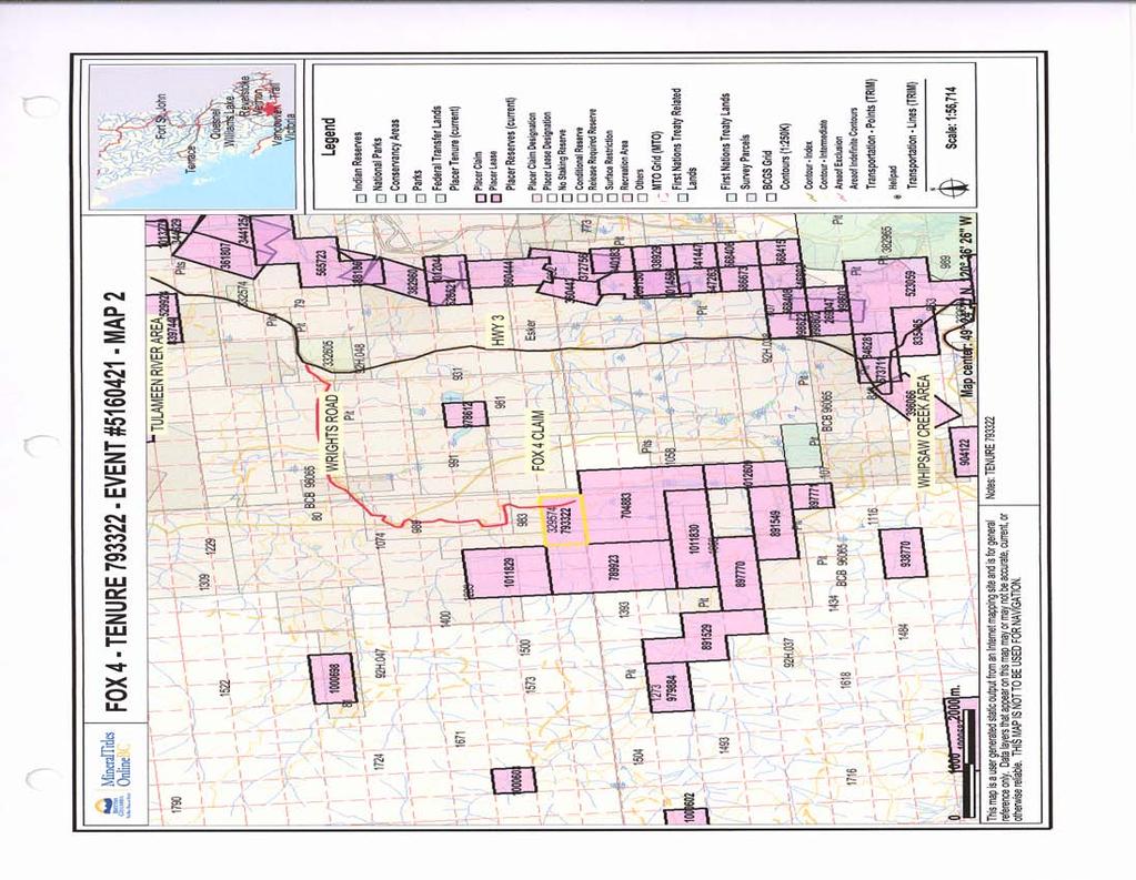
9 FOX 4 - EVENT MAP 3 PROSPECTING AREA ^VfV Fort S\John Quesnel \ Williams.Lake _ Vernon ;., Victoria legend Indian Reserves National Parks Conservancy Areas Parks DL H.047 Federal Transfer Lands Placer Tenure (current) PROSPECTING AREA Placer Claim Placer Lease Placer Reserves (current) Placer Claim Designation M A D FOX 4 CLAIM TENURE DL 75 Placer Lease Designation No Staking Reserve Conditional Reserve Release Required Reserve Surface Restriction Recreation Area Others MTO Grid (MTO) First Nations Treaty Related Lands r-j First Nations Treaty Lands r Integrated Cadastral Fabric r~i Survey Parcels BCGS Grid Contours (TRIM) E A O W 92H H.038 Contour - Index Contour - Index.Indefinite Contour - Index.Depression Contour - Index.Depression Indefinite Contour - Intermediate Contour - Intermediate.lndefinite Contour - Intermediate. Depress ion i Map center: 49 24' 7.0" N, ' 26.9" W H Scale: 1:7,089 This map is a user generated static output from an Internet mapping site and is for general reference only. Data layers that appear on this map may or may not be accurate, current, or otherwise reliable. THIS MAP IS NOT TO BE USED FOR NAVIGATION. Notes: TENURE #793322
PROSPECTING REPORT TENURES # / / CLAIM NAMES OLD SETTLER; OLD SETTLER1; OLD SETTLER2
 2011 PROSPECTING REPORT EVENT - 5160426 TENURES # 688183 / 691903 / 691905 CLAIM NAMES OLD SETTLER; OLD SETTLER1; OLD SETTLER2 COAST CRYSTALINE BELT REGION NEW WESTMINSTER MINING DISTRICT MAP - 092H GPS
PROSPECTING REPORT TENURES # / / CLAIM NAMES OLD SETTLER; OLD SETTLER1; OLD SETTLER2
 2010 PROSPECTING REPORT EVENT # 4820658 TENURES # 688183 / 691903 / 691905 CLAIM NAMES OLD SETTLER; OLD SETTLER1; OLD SETTLER2 COAST CRYSTALINE BELT REGION NEW WESTMINSTER MINING DISTRICT MAP - 092H GPS
PROSPECTING REPORT. Broken Hill Property. EVENT # TENURE # Tenure Name: Broken Hill. New Westminster Mining Division Map 092H
 2009-2010 PROSPECTING REPORT Broken Hill Property EVENT # 4514071 TENURE # 600988 Tenure Name: Broken Hill New Westminster Mining Division Map 092H Central Coordinate Reference 121 24 26.2 W Longitude
Technical Report. Geochemical Sampling West of Raymond Creek on Vancouver Island. Victoria Mining District 092C 15. UTM Co-ordinates N E
 Technical Report Geochemical Sampling West of Raymond Creek on Vancouver Island Victoria Mining District RECEIVED MINERAL TITLES BRANCH VANCOUVER, B.C. JAN 2 3 /i)13 L.l.g 092C 15 FILI NO. UTM Co-ordinates
PROSPECTING REPORT. Karen Creek. EVENT # TENURE # Tenure Name: Karen Creek. New Westminster Mining Division Map 092H
 2008-2009 PROSPECTING REPORT Karen Creek EVENT # 4269354 TENURE # 578618 Tenure Name: Karen Creek New Westminster Mining Division Map 092H Central Coordinate Reference 121 17 30.7 W Longitude 49 26 21.9
PROSPECTING REPORT. Deneau Creek. EVENT # TENURE # Tenure Name: Deneau Creek. New Westminster Mining Division Map 092H
 2010-2011 PROSPECTING REPORT Deneau Creek EVENT # 4844921 TENURE # 578616 Tenure Name: Deneau Creek New Westminster Mining Division Map 092H Central Coordinate Reference 121 18 04.5 W Longitude 49 26 13.9
Internet Mapping Framework 1 (IMF) to Common Web Mapping (CWM) Legend Comparison
 to Common Web Mapping (CWM) Legend Comparison") Internet Mapping Framework 1 (IMF) to Common Web Mapping () Legend Comparison IMF Legend Legend Folders Titles (MTO) - Mineral, Placer, Coal Map Viewers.. 3 Coal Grid - Coal Map Viewer. 4 Tenure History
Internet Mapping Framework 1 (IMF) to Common Web Mapping () Legend Comparison IMF Legend Legend Folders Titles (MTO) - Mineral, Placer, Coal Map Viewers.. 3 Coal Grid - Coal Map Viewer. 4 Tenure History
VANCOUVER, B.C. Prospecting, Technical Assessment Report
 VANCOUVER, B.C. Le Baron Prospecting Port Renfrew, BC Prospecting, Technical Assessment Report The Le Baron Prospecting / The Sombrio Gem Stone Project Vancouver Island, British Columbia Victoria Mining
ASSESSMENT FOR THE 2007 DRILLING REPORT OF THE CHINA KNOWS
 ASSESSMENT FOR THE 2007 DRILLING REPORT OF THE R.8.C CHINA KNOWS 2-554933 MINERAL CLAIMS SITUATED IN THE OMENICA MINING DIVISION LATITUDE: 54 26' 37" N LONGITUDE: 126 24' 29" W OWNED BY: JOHN WESLEY MOLL
Title page. Report of physical exploration and development for placer tenures # and# know as: "Old Legends"
 & Title page Report of physical exploration and development for placer tenures #526546 and#526548 know as: "Old Legends" NTS: 92G098 Site#l Site#2 N49o 59.43.8 N 49 59.8.2 W 22 30.39.0 W 22 3.0.0 UTM:
PROSPECTING REPORT. Silver Dollar Property. EVENT # TENURE # Tenure Name: GPEX Silver Dollar
 2008-2009 PROSPECTING REPORT Silver Dollar Property EVENT # 4267989 TENURE # 555462 Tenure Name: GPEX Silver Dollar Similkameen Mining Division Map 092H Central Coordinate Reference 120 06 26.9 W Longitude
PROSPECTING REPORT. Medallion Property. EVENT # TENURE # Tenure Name: GPEX CLVIII Medallion
 2006-2007 PROSPECTING REPORT Medallion Property EVENT # 4167980 TENURE # 540362 Tenure Name: GPEX CLVIII Medallion Watson Bar Region Clinton Mining Division Map 092O Central Coordinate Reference Long.
ASSESSMENT REPORT ON THE PEAVINE PROJECT. DGW & Associates # Alberni Street, Vancouver, British Columbia, V6E 4V2
 ASSESSMENT REPORT ON THE PEAVINE PROJECT KAMLOOPS MINING DIVISION BRITISH COLUMBIA NTS 082M 12 Latitude 51 36' 19.0"North -- Longitude --119 47' 27.0"West UTM Zone 11, NAD 83 5720827N 306744E Prepared
Prospecting Report on the Dynasty Jade Placer Dorthy Creek Claims
 Prospecting Report on the Dynasty Jade Placer Dorthy Creek Claims Claims 550004, 541288, 547670 Mining Division - Liard NTS or BCGS location 104J080 Latitude and longitude of geographic centre of work
Prospecting Report on the Dynasty Jade Claims
 Prospecting Report on the Dynasty Jade Claims Claims 519762, 520237, 520336 Mining Division - Liard NTS or BCGS location 104J080 Latitude and longitude of geographic centre of work 58.78 N 130.08 W Owner
O ITHIS )WE OF WORK IN I EXTENT OF WORK I I PROJECT COSTS I ON WHICH CLAIMS (IN METRIC UNITS) APPORTIONED (id. support) GEOLOGICAL (scale, area)
WE OF WORK IN I EXTENT OF WORK I I PROJECT COSTS I ON WHICH CLAIMS (IN METRIC UNITS) APPORTIONED (id. support) GEOLOGICAL (scale, area)") Geological Survey Branch TITLE OF REPORT [type of SUNOY(S)] TOTAL COST 1 MINERAL INVENTORY M OWNER@) MAILING ADDRESS -.,-- a 5 -a OPERATOR(S) [who paid ffo the wnk) 2) MAILING ADDRESS 76e2 HWY 97/gm LP
Geological Survey Branch TITLE OF REPORT [type of SUNOY(S)] TOTAL COST 1 MINERAL INVENTORY M OWNER@) MAILING ADDRESS -.,-- a 5 -a OPERATOR(S) [who paid ffo the wnk) 2) MAILING ADDRESS 76e2 HWY 97/gm LP
Technical Report. Geochemical Sampling of Raymond Creek on Vancouver Island. Victoria Mining District 092C 15. UTM Co-ordinates N E
 Technical Report Geochemical Sampling of Raymond Creek on Vancouver Island Victoria Mining District 092C 15 UTM Co-ordinates 5414044N 389836E Owner of Claims is Dean Arbic(133434) Report Written by Dean
Report on Exploration of Waterhen Claims Port Alberni Area of British Columbia. n 1 - Tenure # Tenure #399108
 Report on Exploration of Waterhen Claims Port Alberni Area of British Columbia n 1 - Tenure #399107 2 - Tenure #399108 Location: Victoria Mining Division Owner: Barry Hanslit Operator: Barry Hanslit A
PERCY CONTRACTING SERVICES LTD.
 GEOLOGICAL REPORT ON TEN PLACER LEASES (3139, 3140, 3141, 3142, 3143, 3144, 3145, 3146, 3147, 3148) MOREHEAD CREEK CARIB00 MINING DIVISION, B.C. 938/12W (52 38 N, 121 47 W) For PERCY CONTRACTING SERVICES
STONE MOUNTAIN. Owner: Kimberly Gale Powell. Technical Report for Tenures: , , , , ,
 STONE MOUNTAIN Owner: Kimberly Gale Powell Technical Report for Tenures: 415067, 415068, 415069, 415070, 415071, 415072. Approximate Property Location Latitude 49 29 3 North Longitude: 120 40 47 West Similkameen
Geochemical, Prospecting, and Technical Assessment Report
 Geochemical, Prospecting, and Technical Assessment Report The Le Baron Prospecting / Juan de Fuca Project 2008 Vancouver Island, British Columbia Victoria Mining Division NTS: 092C059 48 degrees -31' -
ASSESSMENT REPORT TITLE PAGE AND SUMMARY
 ASSESSMENT REPORT TITLE PAGE AND SUMMARY TITLE OF REPORT: 2016 Prospecting Report Sphynx Claim TOTAL COST: $167.56 AUTHOR(S): Giacomo Grassi SIGNATURE(S): NOTICE OF WORK PERMIT NUMBER(S)/DATE(S): STATEMENT
58 l'gr'n 'E. Date: January 23, 1979 ASSESSMENT REPORT PLACER SAMPLING & JADE BOULDER EVALUATION PLACER LEASE Liard Mining Divison 1041/7E
 ASSESSMENT REPORT PLACER SAMPLING & JADE BOULDER EVALUATION PLACER LEASE 1711 Liard Mining Divison 1041/7E 58 l'gr'n 18 38'E Owner & operator: Cry Lake Jade Mines Ltd. Author: A.M. Homenuke, P.Eng. Date:
Prospecting Report Grandpa Claim Group
 2010 2011 Prospecting Report Grandpa Claim Group TENURE NUMBER: 705523 EVENT NUMBER: 4825383 TENURE NAME: GRANDPA Lillooet Mining Division Map 092I Central Coordinate Reference 50 57 30 N Latitude 121
Prospecting Report 'S Office i DB Property, B.C. -J Negro Creek Nelson Mining District NTS 82F.050. Operator: Kootenay Gold Inc.
 . '.' I"' i9 12 Prospecting Report 'S Office i DB Property, B.C. -J Negro Creek Nelson Mining District NTS 82F.050 Operator: Kootenay Gold Inc. Owner: Darlene Lavoie Work Performed Summer of 2007 Report
56H. This system allows definition of points on the Earth s surface to within 100 meters. Page 20. Navigation Systems Basics of Maps
 Grid References Many maps are provided with the standard grid overlaying them. This provides a simple and accurate method for finding features on the map. It is a network of intersecting parallel lines
GEOLOGICAL MAPPING REPORT ON THE ASH MINERAL CLAIM OSOYOOS MINING DIVISION ASHNOLA RIVER MAP SHEET NTS M092,H019 MCBRIDE CREEK AREA, ASHNOLA RIVER,
 GEOLOGICAL MAPPING REPORT ON THE ASH MINERAL CLAIM OSOYOOS MINING DIVISION ASHNOLA RIVER MAP SHEET NTS M092,H019 LATITUDE 49 o O6, LONGITUDE 120 o 22 MCBRIDE CREEK AREA, ASHNOLA RIVER, KEREMEOS, B.C. CANADA
Montgomery Bedrock Geology 21d-Gowganda Formation: conglomerate, sandstone, siltstone, argillite
 Work Report 2014 Trenching Montgomery Township G-3303 Claim #4259384,4245818 Sault Ste. Marie Mining Division Michael & Yvon Gagne Montgomery Copper Property 1 P a g e 2 P a g e Montgomery Bedrock Geology
ASSESSMENT REPORT TITLE PAGE AND SUMMARY
 ASSESSMENT REPORT TITLE PAGE AND SUMMARY TITLE OF REPORT: 2016 Prospecting Report Midas Claim TOTAL COST: $314.61 AUTHOR(S): Giacomo Grassi SIGNATURE(S): NOTICE OF WORK PERMIT NUMBER(S)/DATE(S): STATEMENT
Assessment Report for Freedom Claim Nanaimo Mining Division NTS Map 92F/11W. Located: 22 miles west of Courtenay, BC
 DEC 2 ^ Gold Commissioner's Office VANCOUVER, B.C. PHYSICAL EXPLORATION WORK Assessment Report for Freedom Claim 570706 Nanaimo Mining Division NTS Map 92F/11W Located: 22 miles west of Courtenay, BC 49
REPORT OF PHYSICAL EXPLORATION AND DEVELOPMENT Section 15 - Mineral Tenure Act Regulation
 1. EVENT NUMBER(S) 1234567 4. RECORDED HOLDER Doe 123 Main Street REPORT OF PHYSICAL EXPLORATION AND DEVELOPMENT Section 15 - Mineral Tenure Act Regulation Mineral Titles and Policy Branch Ministry of
Ronin Placer Ground-penetrating Radar Survey Report
 Ronin Placer Ground-penetrating Radar Survey Report Tenures: 837095, 837097 Mining Division: Greenwood NTS Location: 082E/03 Geographic Center Coordinates: UTM Zone 11, E 345340, N 5438730 Claims Owner:
BRY PLACER GROUP. Assessment Report Gravel,silt sampling and panning on. Claims: , , Located on map sheet 093A 062
 BRY PLACER GROUP Assessment Report 2012 Gravel,silt sampling and panning on Claims: 523068, 522278, 589718 Located on map sheet 093A 062 5~2 57'3/A/ / 31 Hi' 9 " )Aj Cariboo D/viS''on Owner-operator Egil
Technical and Geochemical Assessment Report. Le Baron Prospecting. Harris Creek Limestone Project
 Technical and Geochemical Assessment Report Le Baron Prospecting < * Le Baron Prospecting Harris Creek Limestone Project Vancouver Island, British Columbia Tenure #504668 + #504670 Victoria Mining Division
1 FILMED 1. FILE NO:!..rsrru -* -. GRAND TWO CLAIM
 FILE NO:!..rsrru -* -. GRAND TWO CLAIM REPORT ON 1993 ASSESSMENT WORK GRAND TWO CLAIM REC. NO. 301849 NELSON MINING DIVISION NTS MAP SHEET 82F6/W 49 25'51" NORTH 117 18'08" WEST 1 FILMED 1 AUTHOR: R. Jordan,
ASSESSMENT REPORT TITLE PAGE AND SUMMARY
 ASSESSMENT REPORT TITLE PAGE AND SUMMARY TITLE OF REPORT: 2016 Prospecting Report Mystery Beryl TOTAL COST: $1299.09 AUTHOR(S): Giacomo Grassi SIGNATURE(S): NOTICE OF WORK PERMIT NUMBER(S)/DATE(S): STATEMENT
DEVELOPMENT REPORT. Lone I Mineral Claim Group. Wild Horse River Area Cranbrook, B.C.
 DEVELOPMENT REPORT Lone I Mineral Claim Group Wild Horse River Area Cranbrook, B.C. Fort Steele Mining District NTS 82G/12E 49 38 35 Latitude 115 38 00 Longitude LONE PEAK PLACER LTD. 514-13th Avenue South
GPEX Mineral Property Portfolio. Coquihalla Gold Belt. ~ Ladner Suite ~
 GPEX Mineral Property Portfolio Coquihalla Gold Belt ~ Ladner Suite ~ GPEX s Ladner Suite consists of four properties, the Silver Salem, the Emancipation East, the Ladner Junction and West Hozameen claims.
PROSPECTING REPORT THE WALLACE CLAIM OMENICA MINING DIVISION. 54" x6" 3.d d. for. Reako Exlorat ions Ltd. Wallace Rev. C.G.
 PROSPECTING REPORT ON THE WALLACE CLAIM OMENICA MINING DIVISION 54"44 14 1x6" 3.d d by David A. Howard P.Eng. for Reako Exlorat ions Ltd. Claim Locat ion Wallace Rev. C.G. #1560 Dome Mountain Area 9 3
GIS: Introductory Guide to MapPlace. Workshop Agenda. How the Maps Work. Geographic Information Systems. -The MapPlace is a web GIS application
 1 Introductory Guide to MapPlace Workshop 2007 Larry Jones MapPlace & Geoscience Databases Pat Desjardins Corporate GIS Gib McArthur Manager, Resource Information Kirk Hancock MINFILE Geologist Ward Kilby
We are committed to providing accessible customer service. If you need accessible formats or communications supports, please contact us.
 We are committed to providing accessible customer service. If you need accessible formats or communications supports, please contact us. Nous tenons à améliorer l accessibilité des services à la clientèle.
Vancouver Island and Coast
 Places in B.C. This handout package provides students with a brief overview of one of seven regions in B.C. These descriptions will help students audit the different types of energy (see the Energy Primers)
GEOCHEMICAL STREAM SAMPLING. on the PLACER LEASES NO. Jordan River/Bear Creek Area. Victoria Mining Division. Latitude 48 degrees 32 minutes N.T.S.
 GEOCHEMCAL STREAM SAMPLNG on the PLACER LEASES NO P. 8149, 8150, 8151, 8152, 8161, 8162, 8163, 8400, 10844, 10845 Jordan River/Bear Creek Area Victoria Mining Division Latitude 48 degrees 32 minutes Longitude
EMORY PLACER CLAIM Yale Region New Westminster Mining Division
 EMORY PLACER CLAIM Yale Region New Westminster Mining Division EVENT # 4646011 TENURE # 608187 Tenure Name: Emory NTS Map 92H/11 Approximate Centre of Tenure 121 25 12 W Longitude 49 30 44 N Latitude Report
Date Submitted: June General Nature of Report: Examination of Placer Samples
 General Nature of Report: Examination of Placer Samples Claim: Gold Channel, Record Number 3775!8 1 (Gold Channel Placer Property) Mining Division: Cariboo NTS 093 G 09 W and E Latitude 520 23 N' Longitude1210
PROSPECTING REPORT. re. Minera.1 C laims
 PROSPECTING REPORT re. Minera.1 C laims P R 1 Record #3052 (6) P R 2 Record #3053 (6) p R 3 Record #3054 (6) at Ilong.129, Latt. 58 20' in the Two Mile Creek area of Turnagain River drainage system in
GEOLOGICAL BRAN ASSESS
 TITLE PAGE This report covers assessment work performed on the Mundy group, located in the Boundary Creek area, north of Greenwood, British Columbia. The work comprises of THM soil testing, trenching and
4J)SESSMEN'I' REPORT BRANCH. cc" FILE No: ASSESSMENT REPORT VICTORIA MINING DIVISION. Latitude 123O SF' Longitude 48O S5'
SESSMEN'I' REPORT BRANCH. cc FILE No: ASSESSMENT REPORT VICTORIA MINING DIVISION. Latitude 123O SF' Longitude 48O S5'") ASSESSMENT REPORT - ON THE ORM 1 MINERAL CLAIM VICTORIA MINING DIVISION NTS 92B cc" Latitude 123O SF' Longitude 48O S5' 3-2. w N C FILE No: @&@LOGI.CAL BRANCH 4J)SESSMEN'I' REPORT Date : June 1, 1990 TABLE
ASSESSMENT REPORT - ON THE ORM 1 MINERAL CLAIM VICTORIA MINING DIVISION NTS 92B cc" Latitude 123O SF' Longitude 48O S5' 3-2. w N C FILE No: @&@LOGI.CAL BRANCH 4J)SESSMEN'I' REPORT Date : June 1, 1990 TABLE
EXPLORATION and DEVELOPMENT REPORT. Conrad Creek. PLACER and MINERAL CLAIMS SOUTHEAST BRITISH COLUMBIA
 EXPLORATION and DEVELOPMENT REPORT on Conrad Creek PLACER and MINERAL CLAIMS in SOUTHEAST BRITISH COLUMBIA Ed Friesen, BSc.E.E., P. Eng 8 Lake Placid Rise SE Calgary, Alberta T2J 5B5 April 2009 1 P age
REPORT ON APPLICATION TO RECORD WORK. on the CLAIM GROUP. BY Owners. issued at Penticton, B.C. Jan 19,1976. issued at Rossland B.C. Jan.
 --.. REPORT ON APPLICATION TO RECORD WORK on the CLAIM GROUP 1976 2133 meters North-North-East Okanagan I- Falls Post Office 0,// --7 L Lat. 493 21 N., Long. 119 33 W
: T^V&^»v^r^ Gold Commissioner's Office *"*, B.C. Le Baron Prospecting Port Renfrew, BC. Prospecting and Technical Assessment Report
 2 1 2009 Gold Commissioner's Office *"*, B.C. Le Baron Prospecting Prospecting and Technical Assessment Report The Herkimer Diamond Project Mount Tzouhalem Vancouver Island, British Columbia Victoria Mining
ASSESSMENT REPORT TITLE PAGE AND SUMMARY
 ASSESSMENT REPORT TITLE PAGE AND SUMMARY TITLE OF REPORT: Assessment Report on Andys Bridge Mineral Claim, Turnagain River Area TOTAL COST: $2,100 AUTHOR(S): Bruce w Downing SIGNATURE(S): Bruce W Downing
GEOLOGICAL SURVEY BRANCH ASSESSMENT REPORT GEOLOGICAL REPORT. on the ELM PROPERTY-TENURE # KAMLOOPS M.D. NTS 921/15W 2012/08/26 J.D.
 GEOLOGICAL REPORT on the ELM PROPERTY-TENURE #508266 KAMLOOPS M.D. NTS 921/15W LA T 50-58 N LONG 120-52 W by J.D.MURPHY OWNER AND OPERATOR 2012/08/26 GEOLOGICAL SURVEY BRANCH ASSESSMENT REPORT TABLE OF
Ronin and Dayton Placer Ground-penetrating Radar Survey Report
 Ronin and Dayton Placer Ground-penetrating Radar Survey Report Tenures: 837095, 837097, 889865, 890187 Mining Division: Greenwood NTS Location: 082E/03 Geographic Center Coordinates: UTM Zone 11, E 345340,
EXPLORATION REPORT Opal Property Group (Five Tenures)
") 2012 EXPLORATION REPORT Opal Property Group (Five Tenures) EVENT # 5327815 TENURES No. 599584, 599585, 605233, 605237 and 605238 Tenure Names: Opal Slopes, Opal Summit, Opal One, Opal Two, and Opal Three
2012 EXPLORATION REPORT Opal Property Group (Five Tenures) EVENT # 5327815 TENURES No. 599584, 599585, 605233, 605237 and 605238 Tenure Names: Opal Slopes, Opal Summit, Opal One, Opal Two, and Opal Three
Compiling historic YCGC data for lower Hunker Creek and reconstructing gold distribution. Sydney van Loon Yukon Geological Survey
 Compiling historic YCGC data for lower Hunker Creek and reconstructing gold distribution Sydney van Loon Yukon Consolidated Gold Corp. inventoried creeks for over four decades; operated up to 12 dredges
COAU PROPERTY LEMHI COUNTY, IDAHO
 COAU PROPERTY LEMHI COUNTY, IDAHO Utah Mineral Resources 447 N 300 W, Suite 3 Kaysville, UT 84037 (801) 544-3421 ojgatten@nae-xploration.com Prepared by: North American Mine Services, LLC. March 21, 2017
CONTOUR MAPS This Enrichment4You e-guide provides a brief overview of contour maps In this e-guide you will: Sample file
 GEOLOGY CONTOUR MAPS CONTOUR MAPS This Enrichment4You e-guide provides a brief overview of contour maps In this e-guide you will: *Learn Basic Facts About Contour Maps *Make a 3-D Contour Map Geology Contour
Le Baron Prospecting. Port Renfrew BC. Geochemical and Technical Assessment Report
 Le Baron Prospecting Geochemical and Technical Assessment Report The Le Baron Prospecting Le Baron #3 - #574300 Vancouver Island, British Columbia Victoria Mining Division NTS: 092C059 124 degrees -19'
ASSESSMENT REPORT ON THE VLF-EM SURVEY. Trail Creek Mining Division NTS: 82 F/4 W Longitude: 1 17' 49' 50" Latitude: 49O 03' 40"
 ASSESSMENT REPORT ON THE JERO 5 MINERAL CLAIM ROSSLAND, BRJTISH COLUMBIA VLF-EM SURVEY Trail Creek Mining Division NTS: 82 F/4 W Longitude: 1 17' 49' 50" Latitude: 49O 03' 40" Owner: Operator: Author:
OWNER OPERATOR: BLACKWATER EXPLORATIONS LTD. REPORT ON SEISMIC REFRACTION SURVEY PLACER GOLD EXPLORATION
 OWNER OPERATOR: BLACKWATER EXPLORATIONS LTD. REPORT ON SEISMIC REFRACTION SURVEY PLACER GOLD EXPLORATION CARIBOO MINING DISTRICT NTS 93G CLAIM PC682023 Latitude 53 13 35.64 Longitude 122 49 40.65 by Russell
Prospecting. Technical Report. I 1 Owner. LeBaron#3 Tenure ## Scott Philli s. Victoria Mining Division Vancouver Island, BC
 ! Gold Commissioner's Office 1 1 VANCOUVER,B.C. Prospecting Technical Report! GOLD COMMlSSiONER-' RECEIVED and RECORDED! JUN 1 2 26! M.R. Y.....! V!CTORlA. B.C. L t 1 LeBaron#3 Tenure ## 49935 I 1 Owner
Reconnaissance. Of the. Denis mineral claims. Situated at Kilometer 844 of the Alaska Highway. Liard Mining Division. Northeastern British Columbia
 Reconnaissance Of the Denis mineral claims Situated at Kilometer 844 of the Alaska Highway Liard Mining Division Northeastern British Columbia N.T.S. 94M.075 Latitude 59 42 25 Longitude 127 13 12 Field
MAPS AND THEIR CLASSIFICATION
 MAPPING MAPS AND THEIR CLASSIFICATION WHAT IS A MAP? A map is representation of the Earth's surface, showing how things are related to each other by distance, direction, and size. Maps are a way of showing
PRECIOUS METALS. owner. JMT Services Corp. GEOCHPlICAL SAMPLING CHELASLIE WCE, NORTH CENTRAL, B.C. OMINECA MINING DIVISION NTS 93F/5E & 6W
 PRECIOUS METALS REPORT ON 1980 RECONNAISSANCE GEOCHPlICAL SAMPLING CHELASLIE WCE, NORTH CENTRAL, B.C. OMINECA MINING DIVISION NTS 93F/5E & 6W LATITUDE 53O28 N LONGITUDE 125O31 W DATES Qp WORK: JULY 10
Topographic Maps and Profiles
 Name: Date: Period: Earth Science Foundations The Physical Setting: Earth Science CLASS NOTES! Topographic Maps [contour maps] -! Topographic maps show three-dimensional shapes in two dimensions Elevation
Assessment Report by the Canadian Nickel Co. Ltd. Magnetometer Survey. Larder Lake Mining Division Lebel Tovnship, Ontario
 32084Nwea67 2.331* LEBEL 010 Assessment Report by the Canadian Nickel Co. Ltd. Magnetometer Survey Larder Lake Mining Division Lebel Tovnship, Ontario Claims L-531657 L-531658 L-531111 Map No.: M-359,
City of Six Project. Gold Mining Property in Downieville, CA. 60 Acres of Claims. Estimated Resource of over 8,800 ounces of Gold
 City of Six Project Gold Mining Property in Downieville, CA 60 Acres of Claims Estimated Resource of over 8,800 ounces of Gold Adjoining the famous Ruby Mine Property Located on a Rich Tertiary Channel
ASSESSMENT REPORT MAGNETOMETER SURVEY GOLDEN ROD, GOLDEN ROD #2. Long.: General Delivery, Vananda, B. C.
 ASSESSMENT REPORT MAGNETOMETER SURVEY GOLDEN ROD, GOLDEN ROD #2 t=/ NTS 92~110w Lat.: Long.: 49O 44' N 124O 34' W Owner: E. Johanson General Delivery, Vananda, B. C. Operator: Rhyolite Resources I nc.
GOLDCLIFF TULAMEEN PORPHYRY COPPER PROJECT COPPER MOUNTAIN CAMP, BRITISH COLUMBIA THE TROJAN-CONDOR COPPER TARGET HIGHLIGHTS
 Suite 350-885 Dunsmuir Street PF 250 764 8879 TF 866 769 4802 Vancouver, BC, Canada FX604 261 8994 info@goldcliff.com V6C 1N5 GCN.TSXV www.goldcliff.com GOLDCLIFF TULAMEEN PORPHYRY COPPER PROJECT COPPER
PHYSICAL WORK REPORT ON THE. KINGDOMlwINERAL LILLOOET MINING DIVISION. NTS Map Sheet 92J/15W. Co-Ordinates North: East
 PHYSICAL WORK REPORT ON THE KINGDOMlwINERAL CLAIM LILLOOET MINING DIVISION NTS Map Sheet 92J/15W Co-Ordinates North: 50 48 East 120 48 For Assessment Work BY Edward Skoda October 15,2002 Vancouver, British
..!I AXE CLAIMS ON THE. for RICHCORE EXPLORATIONS LTO. GREENWOOD MINING DIVISION BRITISH COLUMBIA. Latitude 49O 30"; Longitude 118' 30'W NTS 82E/9W
 ON THE AXE CLAIMS for RICHCORE EXPLORATIONS LTO. GREENWOOD MINING DIVISION BRITISH COLUMBIA Latitude 49O 30"; Longitude 118' 30'W NTS 82E/9W... -... ~ i.,...._.'..!i Vancouver, B.C. September, 1980 P.
faze *7 Annual Report Re: Mineral tenure # (Maid 1) Victoria Mining Division NTS 92C Site # 1 N: 48' W: 124' 06.
 Victoria Mining Division NTS 92C Site # 1 N: 48' W: 124' 06.") faze *7 Annual Report Re: Mineral tenure # 59050 (Maid ) Victoria Mining Division NTS 9C - 070 Site # N: 48' 36.94 W: 4' 06.396 Site # N: 48789-5384789 Site # 3 N: 48' 37.040 W: 4' 07.50 Owner: Brian David
faze *7 Annual Report Re: Mineral tenure # 59050 (Maid ) Victoria Mining Division NTS 9C - 070 Site # N: 48' 36.94 W: 4' 06.396 Site # N: 48789-5384789 Site # 3 N: 48' 37.040 W: 4' 07.50 Owner: Brian David
PHYSICAL WORK REPORT. the BAY CLAIMS. Omineca Mining Division Smithers, British Columbia N.T.S. 93E 13E/W
 PHYSICAL WORK REPORT the BAY CLAIMS Omineca Mining Division Smithers, British Columbia a N.T.S. 93E 13E/W LATITUDE: 53 57 00 N I LONGITUDE: 127 45 OO W for Home Ventures Ltd. 1201-675 West Hastings Street
GPEX Mineral Property Portfolio. Coquihalla Gold Belt. ~ Ladner Suite ~
 GPEX Mineral Property Portfolio Coquihalla Gold Belt ~ Ladner Suite ~ GPEX s Ladner Suite consists of four properties, the Silver Salem, the Emancipation East, the Ladner Junction and West Hozameen claims.
Lab Topographic Maps. Name: Partner: Purpose. Background Information
 Lab Topographic Maps Name: Partner: Purpose The purpose of this lab is to familiarize you with graphic representations of the Earth s surface primarily maps. Simple line maps show the spatial relationship
Assessment Report #
 Table Of Contents Event Sheet #5576884 Exploration Program for 2015 Summery Introduction Location and Access Climate Local Resources and infrastructure Physiography Property Bedrock Geology History of
Exploration in Northwest BC
 Exploration in Northwest BC Paul Wojdak Regional Geologist Minerals North Conference April 18 2008 Q u e s n e l Nechako Bowser S t i k i n e W r a n g e l l Skeena Arch S t i k i n e T e r r a n e Mineral
Assessment Report. on PROSPECTING/SAMPLING. on the. GOLDELUXE Rec. * 42 AURUM RULER ReC. # 72
 .. c I Assessment Report on PROSPECTING/SAMPLING P,jmNO: 4 -. t-1 on the AURUM RULER Group of Placer Claims GOLDELUXE Rec. * 42 AURUM RULER ReC. # 72 Situate: Lillooet Township/Fraser River Ar Lillooet,
Beekeeper Property The Geology South of Mint Lake. Cariboo Mining Division
 Beekeeper Property The Geology South of Mint Lake NTS: 93A/6 Cariboo Mining Division Claims: Beekeeper 1 #I2055 Beekeeper 2 #3892 Beekeeper 3 #7895 Beekeeper 4 #8503 Latitude: Longitude: 52 degrees 24
VICTORIA, BC FILE NO,
 FILE NO, VICTORIA, BC DEC - 7 2006 BFUTISH COLUMBIA Ministry of Energy & Mines Energy & Minerals Division Geological Survey Branch ASSESSMENT REPORT TITLE PAGE AND SUMMARY TITLE OF REPORT [type of survey(s)]
12 tons of high-grade ore was mined from the No. 1 vein with an average grade of 13 g/t gold, 3,250 g/t silver and 23.3% lead.
 DUNWELL MINE GROUP The Dunwell Mine Group (Dunwell, Dunwell East, Bear River/MM and Silvershot properties), which includes the historic, past-producing Dunwell mine, is located 8 km northeast of Stewart
for the Greenwood Mining Division, B.C. NTS 82E/7W Latitude 49' 27' W, Longitude 118' 5 Prepared by a= D. Dylan Watt, B.Sc.
 t. b LOGnO: 37~ -08 m. ACTIO#: for the AMP AMP 2 AMP 3 t AMP 4 CLAIMS Greenwood Mining Division, B.C. NTS 82E/7W Latitude 49' 27' W, Longitude 8' 5 %E c,w zc *& a w Prepared by a= -4c. D. Dylan Watt, B.Sc.
A PRELIMINARY REPORT ON THE ZYMOST2 CLAIM GROtP, TERRACE, B.C.
 NATIVE EXPLORATIONS LTD. A PRELIMINARY REPORT ON THE ZYMOST2 CLAIM GROtP, TERRACE, B.C. INTRODUCTION': The Zymoetz claim group is, at present, held under option by Native Explorations Ltd.. On the 19th
Technical and Geochemical Assessment Report. All the Marbles Mineral Project. Victoria Mining Division
 Technical and Geochemical Assessment Report All the Marbles Mineral Project Port Renfrew BC Tenures#: #411241, #516184, #593659 Victoria Mining Division UTM Maps: 092C069, 092C070 48 degrees - 37' - 1"
TOPOGRAPHICAL SURVEY REPORT ON THE GREENDROP PROPERTY NEAR CHILLIWACK, B.C. 92-H-3/W
 TOPOGRAPHICAL SURVEY REPORT ON THE GREENDROP PROPERTY NEW WESTMINSTER M.D. NEAR CHILLIWACK, B.C. 92-H-3/W Location: The central pap of the claims is located at coordinates 49 08'N, latitude by 121 26'W,
for the Greenwood Mining Division, B.C. NTS 82E/7W 29' W, Longitude 118' 53' N Prepared by D. Dylan Watt, B.Sc.
 for the FltE NO: u VOLT 1, VOLT 2, VOLT 3, & VOLT 4 CLAIMS Greenwood Mining Division, B.C. NTS 82E/7W Latitude 49' 29' W, Longitude 118' 53' N Prepared by D. Dylan Watt, B.Sc. #309-1996 Trutch Street Vancouver,
BUSH NAV BUSH NAV DAY Navigation for Bush Navigation Day. November. WhitehorseD AY. Section 1 Registration, Maps & Checkpoints
 BUSH DAY Navigation for Bush Navigation Day Robert Kirwan, Nunawading SES W NW N NE E If you have little or no bush navigation experience then you will have been teamed up with members that have that experience
Data Quality and Uncertainty
 Data Quality and Uncertainty The power of GIS analysis is based on the assembly of layers of data, but as data layers increase, errors multiply - quality decreases. Garbage in, garbage out. High quality
GEOLOGICAL BRANCH ASSESSMENT RERnRT. Assessment Report on Physical Work. CAYOOSH CONDOR Group of Placer Claims Lillooet Mining Division
 Assessment Report on Physical Work CAYOOSH CONDOR Group of Placer Claims Lillooet Mining Division PC 105 CAYOOSH CONDOR I1 PC 106 CAYOOSH CONDOR John P. La Rue June loth, 1991 Lillooet, B.C. GEOLOGICAL
Technical Report. On the. Owl Claim(s) Date: Jan. 17, Claim # Written By Lucas Handley. Claim Owner
 Date: Jan. 17, Claim # Written By Lucas Handley. Claim Owner") Technical Report On the Owl Claim(s) Date: Jan. 17, 2011 Claim # 837846 838049 838242 859407 Written By Lucas Handley Claim Owner Intro The 4 claims covered in this report cover what was mostly historically
Technical Report On the Owl Claim(s) Date: Jan. 17, 2011 Claim # 837846 838049 838242 859407 Written By Lucas Handley Claim Owner Intro The 4 claims covered in this report cover what was mostly historically
Chapter Review. Things to Know. Objectives. 564 CHAPTER 7 Applications of Trigonometric Functions. Section You should be able to Review Exercises
 564 CHPTER 7 pplications of Trigonometric Functions Chapter Review Things to Know Formulas Law of Sines (p. 5) Law of Cosines (p. 54) sin a = sin b = sin g a b c c = a + b - ab cos g b = a + c - ac cos
ASSESSMENT REPORT. Geochemical Assessment Report. Le Baron Prospecting. Port Renfrew BC. The Le Baron Prospecting - Juan de Fuca Project
 Le Baron Prospecting Geochemical Assessment Report The Le Baron Prospecting - Juan de Fuca Project Vancouver Island, British Columbia Victoria Mining Division NTS: 092C059 48 degrees -31' - 57" N x 124
Traveling the Past into the Present The Regon's Highways & Byways
 Periodic Atlas of the Traveling the Past into the Present The Regon's Highways & Byways David Peterson del Mar, Historian Heather Kaplinger, Cartographer Meg Merrick, Atlas Concept Few of the overland
SELF POTENTIAL SURVEY OVER THE JAY GROUP, INVERMERE AREA GOLDEN MINING DIVISION, BFUTISH COLUMBIA NTS 82W8W7 82W9W LATLONG 50 30' ' FOR
 - GEOLOGICAL SURVEY BRANCH ASSESSMENT REPORTS -- -- DATE RECEI?/::D 06T 10 1996 - SELF POTENTIAL SURVEY OVER THE JAY GROUP, INVERMERE AREA GOLDEN MINING DIVISION, BFUTISH COLUMBIA NTS 82W8W7 82W9W LATLONG
I 4.w.g //old. Lat. 5Oo35T Long T. for. By: James R. Glass, P. Eng. June 6, DUSTY MAC MINES LTD. (N.P.L.)
") 440 6 REPORT ON MAGNETOMETER SURVEY POD GROU'OF CLAIMS HIGHLAND VALLEY KAMLOOPS MINING DIVISION Lat. 5Oo35T Long. 120 55T 9.2 1 //old for DUSTY MAC MINES LTD. (N.P.L.) By: James R. Glass, P. Eng. June
440 6 REPORT ON MAGNETOMETER SURVEY POD GROU'OF CLAIMS HIGHLAND VALLEY KAMLOOPS MINING DIVISION Lat. 5Oo35T Long. 120 55T 9.2 1 //old for DUSTY MAC MINES LTD. (N.P.L.) By: James R. Glass, P. Eng. June
2013 GEOLOGICAL ASSESSMENT REPORT SHERIDAN HILL PROPERTY
 2013 GEOLOGICAL ASSESSMENT REPORT ON THE SHERIDAN HILL PROPERTY NEW WESTMINSTER MINING DIVISION BRITISH COLUMBIA NTS 092G07 49 16 31 NORTH LATITUDE, 122 39 48 WEST LONGITUDE PREPARED FOR Sheridan Hill
GEOLOGICAL BRANCH ASSESSMENT REPORT 12. FItE NO: ACTION: THE GOLDEN MINING DIVISION, GOLDEN, Including THE NTS MAP; M82K/15W
 ACTION: FItE NO: Including 1990 GEO-CHEM SURVEY RESULTS -- THE AVD CLAIMS - THE GOLDEN MINING DIVISION, GOLDEN, B.C. NTS MAP; M82K/15W Lat. 50 deg. 55 Min. Long 116 deg. 55 min. For GEOLOGICAL BRANCH ASSESSMENT
Rail Lake Copper Property (WB Claims) G.M. Depaoli, B.Sc. Geophysicist J.F. ALl.an, P.Eng. (B.C.! July 1973
 G.M. Depaoli, B.Sc. Geophysicist J.F. ALl.an, P.Eng. (B.C.! July 1973") 1973 Geophysical Report TITLE AUTHORS DATE, COI"4ODITY LOCATION-A rea -Mining Division -Coordinates -NTS Rail Lake Copper Property (WB Claims) GM Depaoli, BSc Geophysicist JF ALlan, PEng (BC! July 1973
1973 Geophysical Report TITLE AUTHORS DATE, COI"4ODITY LOCATION-A rea -Mining Division -Coordinates -NTS Rail Lake Copper Property (WB Claims) GM Depaoli, BSc Geophysicist JF ALlan, PEng (BC! July 1973
CONTENTS. Location, Access and History...6. Tenure Status and Geology Regional Andy Property Geology Map...9
 TYPE OFWORK IN THIS REPORT EXTENT OF WORK (rn METRTC UNITS) ON WHICH CLAIMS PROJECT COSTS APPORTIONED (incl. support) GEOLOGICAL (scale, area) Ground, mapping Photo interpretation GEOPHYSICAL (line-kilometres)