Lab Topographic Maps. Name: Partner: Purpose. Background Information
|
|
|
- Virgil Campbell
- 6 years ago
- Views:
Transcription
1 Lab Topographic Maps Name: Partner: Purpose The purpose of this lab is to familiarize you with graphic representations of the Earth s surface primarily maps. Simple line maps show the spatial relationship of major natural features like mountain ranges and rivers, as well as political subdivisions like countries and states. Background Information Topographic Maps Topographic maps are graphic representations of selected features of the Earth s surface plotted to definite scales. The distinguishing aspect of topographic maps is the portrayal of the shape and elevation of the terrain. Such maps record in convenient, readable form, the physical characteristics of the terrain as determined by precise engineering surveys and measurements. Topographic maps have many uses as basic tools for planning and executing projects; they are an essential part of geologic and hydrologic research, of mineral investigations, and of studies on the quantity and quality of fresh water. They greatly facilitate the study and application of flood control, soil conservation, and reforestation. Topographic maps are of prime importance in planning highways, dams, industrial plants, and countless other types of construction. Intelligent and efficient development of natural resources depends on the availability of adequate topographic mapping. Map users include people who have discovered the advantage of topographic maps in the pursuit of outdoor activities such as hunting, fishing, skiing, and hiking. Map Scale. Topographic maps are classified by scale. Map scale defines the relationship between the size of features as shown on the map compared with their size on the Earth s surface. In this respect, a map is a scale model of the land surface, similar to a scale-model airplane, train, or tyrannosaur. Scale is generally stated as a ratio or fraction 1:24,000 or 1/24,000. The numerator represents map distance, and the denominator, a large number, represents horizontal ground distance. Thus the scale 1:24,000 states that any unit, such as 1 inch or 1 centimeter on the map, represents 24,000 of the same unit on the ground. Refer to the table below for a comparison of common map scales. Large-scale maps, such as 1:24,000-scale maps are especially useful for highly developed areas or rural areas where detailed information is needed for engineering planning or similar purposes. Intermediate-scale maps, scales between 1:50,000 to 1:100,000, cover larger areas and are especially suited for land management and planning. Small-scale maps, scales between 1:250,000 and 1:1,000,000, cover very large areas on a single sheet and are useful for comprehensive views of extensive projects or for regional planning. Table of Common Map Scales Scale 1 inch Represents 1 centimeter Represents 1:500,000 8 miles (approx.) 5 kilometers 1:250,000 4 miles (approx.) 2.5 kilometers 1:100, miles (approx.) 1.0 kilometers 1:24,000 2,000 feet 240 meters
2 Topographic Quadrangle Maps. In the United States the best know topographic maps are the U.S. Geological Survey quadrangle series, which range in scale from 1:24,000 to 1:250,000. The basic series are listed below. 7 ½-minute quadrangle (1:24,000 scale) 15-minute quadrangle (1:62,500 scale) Public Land Survey System In the United States, there is another method of locating a position on a map. According to rules devised by Thomas Jefferson, and originally set into law by Congress in 1785, public land at that time was subdivided and surveyed into townships, which are squared, six miles on a side, with boundaries running north-south and east-west. Townships are further subdivided into 36 one-mile square sections. Each township is identified by its position within a grid of northsouth range lines and east-west township lines. Townships run north and south of a reference baseline, while ranges run east and west of a principal meridian, as illustrated below. The shaded township below is identified as Township 2 South, Range 1 West (T 2 S, R 1 W). Townships are subdivided into sections in the pattern shown below. Since each township contains 36 square miles, each section then is one mile by one mile, or one square mile, or 640 acres. Sections are further subdivided as shown below, into quarters (160 acres) and quarters of quarters (40 acres). Locations can thus be specified in quite good detail; for example The 40 acre parcel is in the southeast quarter of the southeast quarter (SE ¼, SE ¼) of section 12. A full description of this parcel would be: SE ¼, SE ¼, Sec 12, T 2 S, R 1 W. Such a description is quite precise, and it is often used for legal descriptions of property, mining claims, oil leases, etc. Which Way is North? At the bottom of every topographic map is a symbol that looks like this: The star represents true north, while the MN refers to magnetic north. A compass north needle will point to the magnetic north, which for most places on Earth is not the same as true north because the Earth s magnetic dipole is not in alignment with the rotational axis of the Earth. The number (14 in this case) is the angle made between true north and the direction a compass needle will point in the given map area, and is known as the magnetic declination. 14 MN Contour Lines Contour lines are the principal means used to show the shape and elevation of the land surface. A contour line is a line of equal elevation. A contour may be defined as an imaginary line on the ground, every point of which is at the same elevation above sea level.

3 Each contour line represents a definite ground elevation measured from mean sea level, and the contour interval is the difference in elevation between adjacent contours. The contour interval, together with the spacing of the contour lines on the map, indicates the slope of the ground. On steep slopes the lines are spaced more closely than on gentle slopes. The basic characteristics of contours are illustrated in the figure below, which shows a perspective view of a river valley and adjoining hills, along with the same features shown on a topographic map. Perspective and Topographic Map View Reading Topo Maps Learning to read topo maps is mainly learning to interpret contour line patterns. For example, a common pattern is the ^ pattern (figure, right), which is characteristic of a stream valley, and the apex of the ^ always points upstream. Closed contour lines (figure, left) indicate hills (one can walk a horizontal path and return to the starting point that is, one can contour the hill, or go around it without climbing or descending). Closed contour lines with hachure lines indicate closed depressions. As the contour interval is constant on any topo map, the relative spacing of the contours indicates the steepness of a slope. Closely spaced contours mean elevations is gained in a relatively short horizontal distance the slope is steep whereas widely spaced contours indicates the same elevation is gained over a broader distance, with a gentle slope. The hill shown is asymmetrical; it has a steep slope on the south side and a more gentle slope on the north side. Slope angle can be calculated using the following formula:
4 Slope ( ) = tan -1 (rise/run) 600 ft ft Tan Ɵ = 60/600 = 0.1 Ɵ = ft Part 1 Contouring Figure 1 is a map of surveyed elevations. The dots represent data points of elevation above sea level, in feet. 1. Draw topographic contours, using a contour interval of 20 feet. You may choose to mark every datum between two contours with the same symbol or color and then group them together as you draw your contours. It is also recommended to use a pencil to draw in contours as even the best of us can make mistakes. 2. Describe the landform. Is it symmetrical? 3. Make a line across the map with a northwest orientation. Label the northwest end of the line as A and the southeast end of the line as A. 4. In the space below, draw a line the same length as A A, then add a perpendicular elevation line with no scale. 5. Sketch what the landform looks like in cross-section on this A A coordinate system.
5
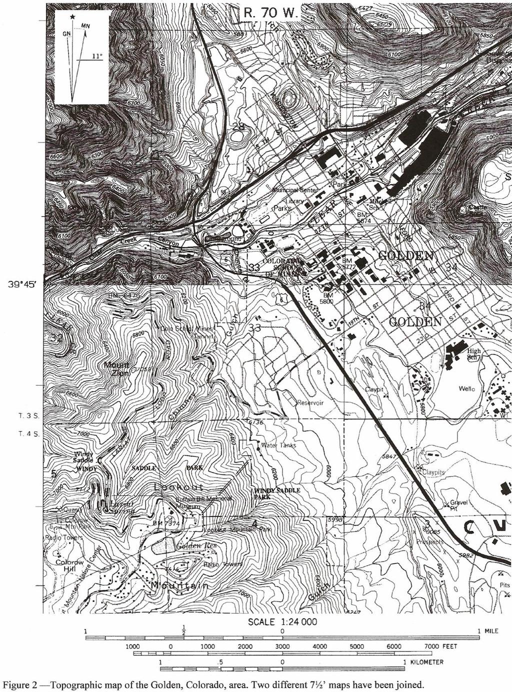
6 Map Use Figure 2 is a topographic map of the Golden, Colorado area. 1. Find Golden High School, circle it, and label it HS. 2. What is the latitude of the high school? 3. Using the Public Land Survey System, describe the location of the high school. The topographic map in Figure 2 was created by joining adjacent parts of the Golden and Morrison 7.5 quadrangle maps. The two maps were originally published with different contour intervals, which shows on Figure 2 as a change in contour density. 4. Label the line along which these two quads are joined with a J at each end. 5. Determine the contour intervals (CI) of each of these two maps: Golden Quad (north) CI Morrison Quad (south) CI Relief is used to describe the elevation differences in an area; an area of rugged terrain has high relief, whereas a fairly flat area has low relief. Relief, then, is the difference between the highest and lowest points in an area. 6. Find the highest point in the area shown by the map, label it B, and determine its elevation. Elevation of point B 7. Find the lowest point on the map and label it B. This would be where Clear Creek leaves the map area (note: because water features are shown on the original topo map in blue, which does not photocopy well, it is difficult to find this point with certainty; the elevation here is about 5,600 feet). 8. What is the topographic relief in this area? Topo maps are useful for determining distance between two points and compass directions, or bearing. 9. Find the conical hill in the NE ¼, Sec. 28, T 3 S, R 70 W, label it C, and measure the distance from the top of this hill to the top of Mt. Zion. Distance (ft) (mi) (m) (km) Because topo maps represent true distances, and because they provide elevation information, they can also be used to calculate the slope angle, as illustrated.
7 10. On the topo map, draw a short line just below the M (in Mount Zion) to the bottom of the 2 (section 32) in the direction of the maximum slope angle, that is, a line approximately perpendicular to the contour lines. Measure the horizontal distance between the contours, and calculate the true slope angle. SHOW YOUR WORK Calculated slope angle 11. Calculate the percent grade of the land surface you measured in question 10. (Slope = vertical distance/horizontal distance x 100%). 12. How much elevation do you gain when you walk from the campus of the Colorado School of Mines up to the M? To answer the following questions, you will use the maps supplied by your teacher. Port Washington, WIS 1. What is the contour interval for this map? 2. Describe the location of Smoky Hill School using the Public Land Survey System. 3. What body of water can be found in the SW ¼, SW ¼, Sec. 4, T11N, R21E? School Hill, WIS 4. When this topo map was produced, what was the magnetic declination? 5. What type of landform can be found in the E ½, Sec. 2, T16N, R21E? Bay City, WIS-MIN 6. What is the contour interval for this map? 7. Describe the location of the radio tower south of Rattlesnake Bluff. 8. What is the maximum elevation of Rattlesnake Bluff?
8 Freedom, WIS 9. Describe the location of Murphy Corner using the Public Land Survey System. 10. Are the gravel pits located in Sec. 9, T23N, R18E active or inactive? Explain. Port Wing, WIS-MIN 11. What direction is the West Fork River Flowing? Explain how you determined the direction of flow. 12. Describe the location of the island located in Lake Superior. 13. Describe the general relief of this area. 14. What is the elevation of the bench mark (BM) located in the SE ¼, NE ¼, Sec. 33, T12N, R21E? Washington Island, WIS 15. What is the approximate elevation of Lake Michigan in the area shown? 16. Describe the location of Fisherman Shoal using the Public Land Survey System? Waupun, WIS Aerial Photo 17. Identify the features labeled in the aerial photo: a. b.
9
B. Topographic maps are also called. contour maps
 Topographic Maps Introduction A. Topographic maps are essential tools in geologic and engineering studies because they show the configuration of Earth's surface in remarkable detail and permit one to measure
APPENDIX A GLOSSARY. Appendix A.1
 APPENDIX A GLOSSARY Appendix A.1 Appendix A.2 Back Bearing A back bearing is measured from the object to your position. It is the exact opposite of a direct bearing. Base Line An imaginary line on the
Topographic Map Series:
 DEFINITION OF A MAP A MAP IS A GEOGRAPHIC PREPRESENTATION OF A PORTION OF THE EARTH S SURFACE DRAWN TO SCALE, AS SEEN FROM ABOVE. IT S USES COLORS, SYMBOLS AND LABELS TO REPRESENT FEATURES FOUND ON THE
Chapter 3 Models of the Earth. 3.1 Finding Locations on the Earth. 3.1 Objectives
 Chapter 3 Models of the Earth 3.1 Finding Locations on the Earth 3.1 Objectives Explain latitude and longitude. How can latitude and longitude be used to find locations on Earth? How can a magnetic compass
Topographic Maps Self-Instruction Lab (2016 edition) Geology 100 David Harbor s Section. 12 inches x 1 mile
 Geology 100 David Harbor s Section. 12 inches x 1 mile") Topographic Maps Name Self-Instruction Lab (2016 edition) Geology 100 David Harbor s Section Topographic maps are an important aid for a geologist, but maps are also useful for hikers, bicyclists, and
Topographic Maps Name Self-Instruction Lab (2016 edition) Geology 100 David Harbor s Section Topographic maps are an important aid for a geologist, but maps are also useful for hikers, bicyclists, and
Laboratory Exercise #2 Introduction to Quadrangle Maps
 page - 1 Laboratory Exercise #2 Introduction to Quadrangle Maps A. Introduction to Quadrangle Maps The United States Geological Survey has developed a nationwide series of quadrangle maps that cover small
Topographic Maps and Landforms Geology Lab
 Topographic Maps and Landforms Geology Lab Ray Rector: Instructor Today s Lab Activities 1) Discussion of Last Week s Lab 2) Lecture on Topo Maps and Elevation Contours 3) Construct Topographic Maps and
Laboratory Exercise #2 Introduction to Quadrangle Maps
 page - Laboratory Exercise #2 Introduction to Quadrangle Maps A. Introduction to Quadrangle Maps The United States Geological Survey has developed a nationwide series of quadrangle maps that cover small
Topographic Maps. More than a Road Map
 Topographic Maps More than a Road Map What is a Topographic Map? Scaled representation of features on the surface of the Earth such as roads, rivers, and plains Provides information about land elevations
Geology 101 Lab Worksheet: Topographic Maps
 Geology 101 Lab Worksheet: Topographic Maps Name: Refer to the Topographic Maps Lab for the information you need to complete this worksheet (http://commons.wvc.edu/rdawes/g101ocl/labs/topomapslab.html).
Using Map and Compass Together
 Using Map and Compass Together In situations where you foresee a potential evacuation on foot, where there are no roads, and no indication as to the direction of travel (i.e., road signs), it is recommended
Latitude and Longitude
 U n i t 3 M a p p i n g P a g e 1 Latitude and Longitude Note: These coordinates are always expressed LATITUDE/LONGITUDE!!! Coordinate System: Using and to find your position on Earth. LATITUDE LATITUDE
Regents Earth Science Unit 1 Earth Dimensions
 Regents Earth Science Unit 1 Earth Dimensions www. BarnesWeb.org 2014-15 edition Name: Name: OBJECTIVES Correctly define: isolines, gradient, topographic map, contour interval, hachured lines, profile,
ORIENTEERING. The challenge is to use the map to decide the best route to complete the course in the quickest time. Orienteering Map. Compass.
 ORIENTEERING Orienteering is similar to a cross-country race but you navigate using a map instead of following a set course. It is an outdoor sport where competitors navigate their own way, you can run,
Earth Science Regents Reading Topographic Maps
 Earth Science Regents Reading Topographic Maps Name Period Quick Tutorial on Degrees, Minutes, and Seconds of Latitude and Longitude A degree of latitude on the surface of the earth is about 70 miles long.
What is a map? A Map is a two or three-dimensional model or representation of the Earth s surface. 2-Dimensional map
 What is a map? A Map is a two or three-dimensional model or representation of the Earth s surface. 2-Dimensional map What is a Map Projection? Planar Projection Projection A Projection is a mathematical
Butte County Fire Department
 Butte County Fire Department Basic Land Navigation Verification Sheet I verify that Print Supervisor s name has completed the Print Employee s name Basic Land Navigation self study guide on. Date Attached
***When doing the lab report write-up, be sure to follow the guidelines.***
 Topographic Maps Lab Vocabulary: topography - study of the shapes and features of the earth's surface elevation - height above sea level bench mark - a point that has been accurately measured for its position
Mapping Earth. How are Earth s surface features measured and modeled?
 Name Mapping Earth How are Earth s surface features measured and modeled? Before You Read Before you read the chapter, think about what you know about maps Record your thoughts in the first column Pair
LAB N - FLUVIAL PROCESSES AND LANDSCAPES
 LAB N - FLUVIAL PROCESSES AND LANDSCAPES Introduction The objective of this lab is to familiarize the student with the work of running water (streams and rivers) and the landforms that they create. Materials
STAAR Science Tutorial 40 TEK 8.9C: Topographic Maps & Erosional Landforms
 Name: Teacher: Pd. Date: STAAR Science Tutorial 40 TEK 8.9C: Topographic Maps & Erosional Landforms TEK 8.9C: Interpret topographic maps and satellite views to identify land and erosional features and
Earth Science Unit 1 Test
 Earth Science Unit 1 Test Multiple Choice Identify the choice that best completes the statement or answers the question. 1. The study of meteorology involves the study of a. climate. c. animals. b. outer
Activities: Map and Compass
 Activities: Map and Compass Determining General Directions Modified with permission from Outdoor Living Skills Series: Map and Compass, Missouri Department of Conservation Overview: Students use the sun
Topo Map Tidbits. Adapted from: An original Creek Connections activity. Creek Connections, Box 10, Allegheny College, Meadville, Pennsylvania, 16335
 Topo Map Tidbits Adapted from: An original Creek Connections activity. Creek Connections, Box 10, Allegheny College, Meadville, Pennsylvania, 16335 Introduction to Topographic Maps Grade Level: Basic Duration:
UNIT 1C. USING TOPOGRAPHIC MAPS WHERE IN THE WORLD... ARE YOU?
 UNIT 1C. USING TOPOGRAPHIC MAPS WHERE IN THE WORLD... ARE YOU? TIME 60-90 minutes LEVEL All BENCHMARKS Next Generation Science Standards MS-LS1.D Science & Engineering Practices Developing and Using Models
Butte County Fire Department
 Butte County Fire Department Basic Land Navigation Verification Sheet I verify that Print Supervisor's name Print Employee's name has completed the Basic Land Navigation self study guide on Date Attached
Topographic Maps and Profiles
 Name: Date: Period: Earth Science Foundations The Physical Setting: Earth Science CLASS NOTES! Topographic Maps [contour maps] -! Topographic maps show three-dimensional shapes in two dimensions Elevation
USING THE MILITARY LENSATIC COMPASS
 USING THE MILITARY LENSATIC COMPASS WARNING This presentation is intended as a quick summary, and not a comprehensive resource. If you want to learn Land Navigation in detail, either buy a book; or get
Elevations are in meters above mean sea level. Scale 1:2000
 12.001 LAB 7: TOPOGRAPHIC MAPS Due: Monday, April 11 PART I: CONTOURING AND PROFILES (20 PTS) 1. Contour this area map using a 5 meter contour interval. Remember some fundamental rules of contour lines,
Topographic Maps Lab 1
 Topographic Maps Lab 1 I. Objectives 1. Construct a material model of typical terrain found in a landscape. 2. Construct a topographic map corresponding to the terrain model. 3. Learn how to interpret
Topographic Maps Knowledge of Maps What are they? What are they used for? Why are they important?
 Topographic Maps Knowledge of Maps What are they? What are they used for? Why are they important? Topographic Maps Maps that show the change in elevation of land. Elevation is the height of land above
From Science Olympiad Student Center
 1 of 10 3/5/13 8:18 AM Forums Wiki Test Exchange Image Gallery Score Tracker Road Scholar From Science Olympiad Student Center In Road Scholar, Forum Threads Tests There are no images available for this
Class Notes: Mapping the Earth
 Name: Date: Period: Mapping the Earth The Physical Setting: Earth Science Class Notes: Mapping the Earth I. Latitude and Longitude Map -! Latitude -! Also called These lines intersect Equator -! The North
Date: UNI. world. *Dedicated to
 Name: Date: UNI IT THREE 2D and 3D model s of the natural world *Dedicated to Name: Date: ABSTRACT T AND RATIONALE A topographic map is a type of map that depicts the detail and quantitative representation
Parts of a Map. Map Skills. The Title. There are 4 main parts of a map: The Title The Compass Rose The Map Key The Scale
 Map Skills Parts of a Map There are 4 main parts of a map: The Title The Compass Rose The Map Key The Scale The Title The title of the map is usually at the top and describes the topic of the map Example:
Guided Notes Topographic Maps
 Guided Notes Topographic Maps Map scale Straight line distance Curved line distance Rules of Isolines Contour Lines Hachured Lines Possible elevations Slope & Gradient Direction of River Flow Topographic
Topographic Maps. Take Notes as you view the slides
 Topographic Maps Take Notes as you view the slides Lesson Objectives Define a topographic map and state its uses. Describe how contour lines show the elevations, shape, and slope of the land. Identify
MAPS AND THEIR CLASSIFICATION
 MAPPING MAPS AND THEIR CLASSIFICATION WHAT IS A MAP? A map is representation of the Earth's surface, showing how things are related to each other by distance, direction, and size. Maps are a way of showing
APPENDIX F PRE-COURSE WORK
 APPENDIX F PRE-COURSE WORK F-1 Pre-Course Work F-2 Pre-Course Work Intermediate Wildland Fire Behavior, S-290 Pre-Course Work The pre-course work is designed to ensure that students come to class with
Orienteering Maps & Map Reading Latitude and Longitude Scale
 Orienteering Maps & Map Reading A map is a two-dimensional representation of the three-dimensional world you'll be hiking in. All maps will have some basic features in common and map reading is all about
NAME DATE TOPOGRAPHIC MAPS. Activity 1: Topographic Map Investigation I: More Than a Road Map
 NAME DATE PARTNER(S) TOPOGRAPHIC MAPS Now you have seen how topographic maps can be generated to present the elevation of a terrain. Let s look at some topographic maps and learn how to interpret them.
NCEES FS Practice Exam
 NCEES FS Practice Exam Terrametra Resources Lynn Patten 1. One corner of a 60-ft. 120-ft. lot, otherwise rectangular, is a curve with a radius of 20 ft. and a central angle of 90. The area (ft. 2 ) of
FOR 274 Assignment 3 [20 points] This assignment should be completed and handed at the start of lecture on Friday 16th September.
![FOR 274 Assignment 3 [20 points] This assignment should be completed and handed at the start of lecture on Friday 16th September.](/thumbs/90/101578770.jpg "FOR 274 Assignment 3 [20 points] This assignment should be completed and handed at the start of lecture on Friday 16th September.") FOR 274 Assignment 3 [20 points] Name: This assignment should be completed and handed at the start of lecture on Friday 16th September. 1. Convert the following bearings to azimuths: a. N35 W b. S22 E
FOR 274 Assignment 3 [20 points] Name: This assignment should be completed and handed at the start of lecture on Friday 16th September. 1. Convert the following bearings to azimuths: a. N35 W b. S22 E
King County Explorer Search and Rescue. Course B Map & Compass
 King County Explorer Search and Rescue Course B Map & Compass Disclaimer The intent of this presentation is to provide a basic overview of maps, compasses, and location finding. It is not meant to be a
 Chapter 2 Mapping Our World Picture: Mount Capulin, Raton, NM Cinder Cone Volcano ://3.bp.blogspot.com/_sKz1KwXRzcg/SzFzM52gIoI/AAAAAAAAABk/hguBAT80pk0/s320/capulin.jpg http://www.peteandmelissa.com/images/oklahoma/p1020190.jpg
Notes and Summary pages:
 Topographic Mapping 8.9C Interpret topographical maps and satellite views to identify land and erosional features and predict how these shapes may be reshaped by weathering ATL Skills: Communication taking
Practice Questions. (4) It connects points of equal air temperature. Which of the following items is a model? lithosphere and the troposphere?
 It connects points of equal air temperature. Which of the following items is a model? lithosphere and the troposphere?") Practice Questions Directions Review the Test-Taking Strategies section of this book. Then answer the folowing questions. Read each question carefuly and answer with a correct choice or response. Part
Practice Questions Directions Review the Test-Taking Strategies section of this book. Then answer the folowing questions. Read each question carefuly and answer with a correct choice or response. Part
Chapter 3 SECTION 1 OBJECTIVES
 Chapter 3 SECTION 1 OBJECTIVES Distinguish between latitude and longitude and locate coordinates on maps. Explain how latitude and longitude can be used to locate places on Earth s surface. Explain the
Basic Map Skills for the Outdoors
 Geography 80-20 80% of what there is to know, for 20% of the sweat Basic Map Skills for the Outdoors Map Scale Map source: US Geological Survey Four ways to indicate map scale: Representative fraction
What Is a Globe? Hemispheres. Main Idea Globes and maps provide different ways of showing features of the earth. Terms to Know
 r Main Idea Globes and maps provide different ways of showing features of the earth. Terms to Know hemisphere latitude longitude scale bar scale relief elevation contour line What Is a Globe? A globe is
The Tacoma Mountaineers Wilderness Navigation
 The Tacoma Mountaineers Wilderness Navigation Navigation Fundamentals Navigation in mountainous terrain and wilderness areas requires a set of skills, of which using a map and compass is only one part.
Name Class Date. For each pair of terms, explain how the meanings of the terms differ.
 Skills Worksheet Chapter Review USING KEY TERMS For each pair of terms, explain how the meanings of the terms differ. 1. true north and magnetic north 2. latitude and longitude 3. equator and prime meridian
MAP STUDY: INTERPRETATION OF SURVEY MAPS
 MAP STUDY: INTERPRETATION OF SURVEY MAPS Types and Elements of Maps Maps are drawn to represent the Earth on a piece of paper. Maps are used widely to represent the Earth. Maps use signs and symbols in
Topographic Maps and Mount Rainier
 Topographic Maps and Mount Rainier 50 60 80 70 Learner Objectives: Students will: Read and understand map explanations, including the name, date and origin of the map, scale and contour intervals Understand
1. Identify the Earth motion that provides the basis for our system of local time and time zones.
 Base your answers to questions 1 through 4 on the map below and on your knowledge of Earth science. The map shows the four time zones and some latitude and longitude lines across the continental United
MAPPING THE EARTH HOW DO YOU FIND A LOCATION ON THE EARTH?
 MAPPING THE EARTH HOW DO YOU FIND A LOCATION ON THE EARTH? UNIT TOPICS TOPIC 1: LATITUDE & LONGITUDE TOPIC 2: FIELD MAPS TOPIC 3: TOPOGRAPHIC MAPS TOPIC 4: NYS LANDSCAPES TOPIC 1: LATITUDE & LONGITUDE
56H. This system allows definition of points on the Earth s surface to within 100 meters. Page 20. Navigation Systems Basics of Maps
 Grid References Many maps are provided with the standard grid overlaying them. This provides a simple and accurate method for finding features on the map. It is a network of intersecting parallel lines
5. The topographic map below shows a lake and two rivers.
 Mapping A B1 1. The diagram below shows latitude measurements every 10 degrees and longitude measurements every 15 degrees. What is the latitude and longitude of point X? 5. The topographic map below shows
Compass Basics. Quick Map Basics Review For Compass Use
 Compass Basics Quick Map Basics Review For Compass Use A topographic map tells you where things are and how to get to them, whether you're hiking, biking, hunting, fishing, or just interested in the world
Introduction to Contour Maps
 Your web browser (Safari 7) is out of date. For more security, comfort and Activityengage the best experience on this site: Update your browser Ignore Introduction to Contour Maps What information does
Coordinate Systems & Land Division
 Name Physical Geography Lab Activity #06 Due date Coordinate Systems & Land Division COR Objective 1, SLO 1,3 6.1. Introduction Latitude and longitude are great for sailing around the world, but can be
About places and/or important events Landmarks Maps How the land is, hills or flat or mountain range Connected to maps World Different countries
 What do you think you know about geography? About places and/or important events Landmarks Maps How the land is, hills or flat or mountain range Connected to maps World Different countries What do you
Topographic Maps: Background
 Topographic Maps: Background Introduction From Dr. Terry Swanson, University of Washington, ESS 101 Lab, Geologic Techniques, and Dr. David Kendrick, Hobart and William Smith Colleges, Geneva, NY Geoscientists
Map Reading & Compass Use
 Spring 2013 Kestrel Land Trust Page 2 / 10 Contents Map Basics... 3 Map Types... 3 Terrain Association... 4 Estimating Distance: Pacing... 4 Contour Lines... 5 Navigating with a Compass... 6 Compass Types...
AS 410 Land Navigation. Chpt 4-1
 AS 410 Land Navigation Chpt 4-1 Overview Types of Maps Map Legends / Scales Latitude and Longitude Orienteering Why? Why important to learn how to read a compass and map? No cell phone coverage Mountain
The ABC's of Compass and Map STUDENT WORKBOOK
 The ABC's of Compass and Map STUDENT WORKBOOK 1 EXERCISE 1: Compass Part Identification Directions: Match the terms below with the correct parts on the compass diagram. NOTES: A. Azimuth Ring B. Compass
Chapter 02 Maps. Multiple Choice Questions
 Chapter 02 Maps Multiple Choice Questions 1. Every projection has some degree of distortion because A. a curved surface cannot be represented on a flat surface without distortion. B. parallels and meridians
Earth and Space: Topographic Maps Satellite Images
 Earth and Space: Topographic Maps Satellite Images Earth and Space: Formative Assessment Activities for Earth and Space Topographic Maps Satellite Images Teacher Pages Purpose The purpose of this station
Map Reading: Grades 4 & 5
 Map Reading: Grades 4 & 5 Grades: 4,5 Team Size: 1-2 competitors Duration: 25 minutes Supervisors: Sriram Garapati, Rebecca Neill-Totsuka Summary Description Students will solve a mystery using different
1/28/16. EGM101 Skills Toolbox. Map types. Political Physical Topographic Climate Resource Road. Thematic maps (use one of the above as backdrop)
") EGM101 Skills Toolbox Map types Political Physical Topographic Climate Resource Road Thematic maps (use one of the above as backdrop) Map Types Deriving information from maps Hydrographic Geological Soils
EGM101 Skills Toolbox Map types Political Physical Topographic Climate Resource Road Thematic maps (use one of the above as backdrop) Map Types Deriving information from maps Hydrographic Geological Soils
11. ALPINE GLACIAL LANDFORMS
 Geomorphology 11. Alpine Glacial Landforms 11. ALPINE GLACIAL LANDFORMS 40 Points One objective of this exercise is for you be able to identify alpine glacial landforms and measure their characteristics.
Basic Land Navigation
 A Publication of the National Wildfire Coordinating Group National Interagency Incident Management System Basic Land Navigation PMS 475 June 2007 NFES 2865 JUNE 2007 NFES 2865 Sponsored for NWCG publication
GDC MEMORIAL COLLEGE BAHAL (BHIWANI)
") GDC MEMORIAL COLLEGE BAHAL (BHIWANI)-127028 Lab Manual Geography (B.A 1 st Semester) Department of Geography Content 1. Cartography 2. Maps and their types 3. Map scale 3.1 Methods of expressing a scale
GDC MEMORIAL COLLEGE BAHAL (BHIWANI)-127028 Lab Manual Geography (B.A 1 st Semester) Department of Geography Content 1. Cartography 2. Maps and their types 3. Map scale 3.1 Methods of expressing a scale
CONTOUR MAPS This Enrichment4You e-guide provides a brief overview of contour maps In this e-guide you will: Sample file
 GEOLOGY CONTOUR MAPS CONTOUR MAPS This Enrichment4You e-guide provides a brief overview of contour maps In this e-guide you will: *Learn Basic Facts About Contour Maps *Make a 3-D Contour Map Geology Contour
b. What is the length, width (ft), and direction of flow of Seafield Lake?
, and direction of flow of Seafield Lake?") FOR 274 Assignment 3 [50 points] Name: Section: This assignment should be completed and handed in to the assignment box in the Forest Resources office by noon on Monday 17th of September. Partial credit
FOR 274 Assignment 3 [50 points] Name: Section: This assignment should be completed and handed in to the assignment box in the Forest Resources office by noon on Monday 17th of September. Partial credit
2. Construction of a Topographic Profile. State the vertical scale and vertical exaggeration in the spaces provided.
 QUESTIONS 2, PART A 1. Construction of a Contour Map. - 1-2. Construction of a Topographic Profile. State the vertical scale and vertical exaggeration in the spaces provided. Horizontal scale is 1 inch
Lecture 9: Reference Maps & Aerial Photography
 Lecture 9: Reference Maps & Aerial Photography I. Overview of Reference and Topographic Maps There are two basic types of maps? Reference Maps - General purpose maps & Thematic Maps - maps made for a specific
Mapping Earth. Technology and Mapmaking
 CHAPTER 1 LESSON 2 Mapping Earth Technology and Mapmaking Key Concepts What can a topographic map tell you about the shape of Earth s surface? What can you learn from geologic maps about the rocks near
Approximately how many inches of average yearly precipitation does Rochester, New York, receive?
 1. Base your answer to the following question on the isoline map below, which shows the average yearly precipitation, in inches, across New York State. Approximately how many inches of average yearly precipitation
What Do You See? FOR 274: Forest Measurements and Inventory. Area Determination: Frequency and Cover
 What Do You See? Message of the Day: Many options exist to determine the size, area, or extent of a feature on a landscape FOR 274: Forest Measurements and Inventory Lecture 7: Measures of Land Area Frequency
USING THE MILITARY LENSATIC COMPASS
 USING THE MILITARY LENSATIC COMPASS WARNING This presentation is intended as a quick summary, and not a comprehensive resource. If you want to learn Land Navigation in detail, either buy a book; or get
Earth s Dimensions. Earth s shape. Evidence. Spheres of Earth: 1) Lithosphere- includes: 2) Hydrosphere includes: 3) Atmosphere - Earth Dimensions 23
 Lithosphere- includes: 2) Hydrosphere includes: 3) Atmosphere - Earth Dimensions 23") Earth s Dimensions Earth s shape Evidence Spheres of Earth: 1) Lithosphere- includes: 2) Hydrosphere includes: 3) Atmosphere - Earth Dimensions 23 Selected Properties of Earth s Atmosphere: Earth Science
Earth s Dimensions Earth s shape Evidence Spheres of Earth: 1) Lithosphere- includes: 2) Hydrosphere includes: 3) Atmosphere - Earth Dimensions 23 Selected Properties of Earth s Atmosphere: Earth Science
1. The topographic map below shows a depression contour line on Earth's surface.
 1. The topographic map below shows a depression contour line on Earth's surface. Points A, B, C, and D represent surface locations. Contour line elevations are in feet. Which profile best shows the topography
Wayne E. Sirmon GEO 301 World Regional Geography
 Wayne E. Sirmon GEO 301 Geography 301 Geography 301 MAP: A graphic representation of a portion of the earth s surface dawn to scale, as seen from above. Types of Maps Climate maps give general information
Simple Solutions Social Studies Level 2. Level 2. Social Studies. Help Pages
 Level 2 Social Studies 147 148 adobe houses with bricks made of clay and straw ancestor a family member who lived before us appoint choose; leaders can appoint others barter trading one thing for another
A) greatest in diameter at the Equator C) 53 N B) Albany D) 13.8 billion years B) cosmic background radiation
 greatest in diameter at the Equator C) 53 N B) Albany D) 13.8 billion years B) cosmic background radiation") 1. Measurements taken from space show the Earth to be A) greatest in diameter at the Equator B) greatest in diameter at the poles C) a perfect sphere D) pear shaped 2. The diagram below represents an observer
1. Measurements taken from space show the Earth to be A) greatest in diameter at the Equator B) greatest in diameter at the poles C) a perfect sphere D) pear shaped 2. The diagram below represents an observer
Maps and Globes. By Kennedy s Korner
 Maps and Globes By Kennedy s Korner Map Key or Symbols Maps use symbols to show places and things on Earth. Symbols are drawings that stand for something real. A map key tells you what each symbol stands
GEOL 02: Historical Geology Lab 14: Topographic Maps. Name: Date:
 GEOL 02: Historical Geology Lab 14: Topographic Maps Name: Date: A topographic map is a two dimensional (flat) representation (model) of a three dimensional land surface (landscape). It shows landforms
Practice Packet Topic 2: Measuring Earth
 Practice Packet Topic 2: Measuring Earth Vocabulary: Lesson 1: Lesson 2: Name: Lesson 3: Mini Lesson: Latitude Longitude Pre-Test 1. To locate exact places on the earth, one must look at a. The intersecting
Map reading notes. It is a very useful kind of map that shows the topography of an area, i.e whether it is flat, undulating, rugged or mountainous
 Introduction Map reading notes In the course of 2 or 3 years course, Candidates will be exposed to topographical maps from tropical countries such as Mauritius, Tanzania, Zimbabwe and Jamaica. Many of
LESSON 2: INTRODUCTION TO TOPOGRAPHICAL MAPS
 LESSON 2: INTRODUCTION TO TOPOGRAPHICAL MAPS Finding your way if you become separated from a group. PURPOSE This lesson presents an overview of topographic maps. It describes their characteristics and
Road Scholar. Williamette Valley Invitational Practice Tournament
 Road Scholar Williamette Valley Invitational Practice Tournament Rules for this Event As you complete this event, enter your answers on the online data sheet. You may click "submit" when done and quietly
Map Reading: Grades 2 & 3
 Map Reading: Grades 2 & 3 Grades: 2, 3 Team Size: 1-2 competitors Duration: 25 minutes (5 minute introduction, 20 minutes for questions) Supervisors: Rebecca Neill-Totsuka, Sriram Garapati Summary Description
CHAPTER EXIT CHAPTER. Models of Earth. 3.1 Modeling the Planet. 3.2 Mapmaking and Technology. 3.3 Topographic Maps CHAPTER OUTLINE
 EXIT CHAPTER.1 Modeling the Planet.2 Mapmaking and Technology. Topographic Maps CHAPTER OUTLINE CHAPTER.1 Modeling the Planet A flat of Earth is a convenient tool, but it can distort the shape, distance,
Directed Reading. Section: Types of Maps
 Skills Worksheet Directed Reading Section: Types of Maps 1. What are some of the characteristics of an area shown on maps used by Earth scientists? a. types of animals, types of plants, types of minerals
Advanced Vectors. Table of Contents
 Advanced Vectors Table of Contents I. Location and Distance on Earth 2 Introduction Determining Latitude Latitude and the North Star Determining Longitude Longitude and Time Using Earth's Grid System Google
Do Now. Copy the ques:on below and write down an. Sketch a profile of the books on the front table.
 Do Now Copy the ques:on below and write down an answer Sketch a profile of the books on the front table. Measurements Contour Lines How do we represent Eleva:on on a flat piece of paper? Eleva?on height
Map Skills Unit. Note taking unit
 Map Skills Unit Note taking unit Introduction To learn about the Earth, we are going to learn about two geographic tools you can use.globes and maps. Globe A globe is a round model of the planet Earth
California Cadet Corps Curriculum on Maps and Navigation. Map Reading LEADERS KNOW THE WAY
 California Cadet Corps Curriculum on Maps and Navigation Map Reading LEADERS KNOW THE WAY 5/22/2017 Map Reading Agenda A1. Introduction to Maps A2. Topographical Map Basics A3. Elevation and Terrain Features
For Sale on Bids. Open House By Appointment
 For Sale on Bids Written Bid Deadline: Friday, September 7, by 12:00 P.M. Noon 52+/- Acres & Storage Facility Grand Forks, ND Property Location: Conveniently located off Interstate 29 and North Washington