Technical Report. On the. Owl Claim(s) Date: Jan. 17, Claim # Written By Lucas Handley. Claim Owner
|
|
|
- Florence Mae McGee
- 5 years ago
- Views:
Transcription
1 Technical Report On the Owl Claim(s) Date: Jan. 17, 2011 Claim # Written By Lucas Handley Claim Owner
2
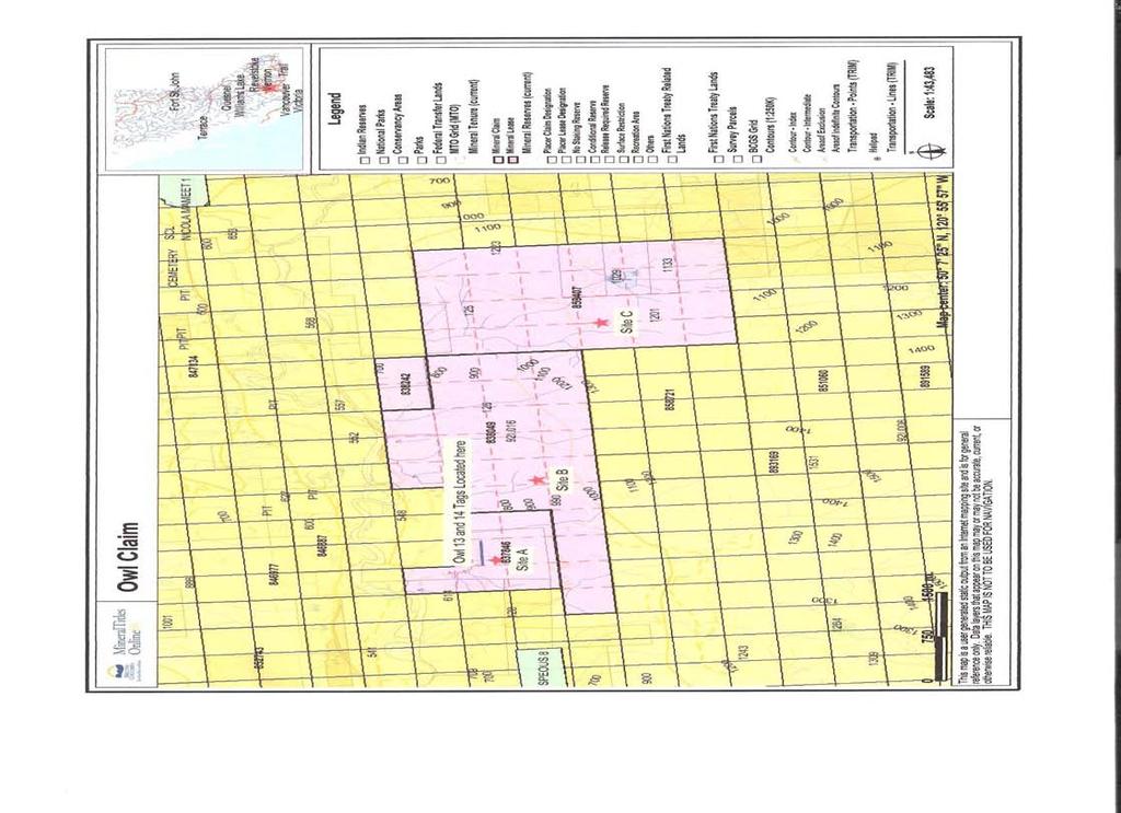
3 Intro The 4 claims covered in this report cover what was mostly historically known as the Owl Property. The claims are , , , and The claims cover an area of 58 Mineral Title Cells, or Ha. The earliest data that I can find on this claim being worked is from the 1960 s. I found several Claim Tags on the Northern Portion of current tenure , calling the claim Owl, registered in 1969 to Marco Kiekle. There is also a minefile report for the old workings and drilling of an area known as Law, which is situated on the NE Slopes of Mt. Mcinnes. It is debatable as to the exact location of the bulk sample, and whether it lays on a claim held by myself or the neighbouring claim. However I was able to locate 1 drill hole from the 1967 program, which does lie on claim # This year s trips to the property were prospecting and mapping missions. Below you will find the data gathered from the 2011 field program. Location The property is located approximately 15kms west of Merritt. Access is off of Hwy 8. Sunshine Valley Road runs along the Northern portions of the claim. Access to the upper levels of the claim is via logging road that runs through private land Work Program The 2011 work program consisted of researching the past work done on the property, as well as a physical prospecting trip to have a look around the property to try and identify past work sites as well as any sites of interest. A quick trip to the property in late November of 2010 turned up 4 claim tags. They were labelled Owl 13 and Owl 14, dated August 17, 1969, Located by Marco Kiekle. A detailed visit to the property occurred on several occasions from July 10 th to October 25 th. 3 areas of interest were identified during the visit. The historic pit s location where the bulk sample came from, remains a mystery. As do two of the three drill holes from the 1967 program. The first area explored was found just south of Tomkinson Road and Sunshine Valley Road (Site A). It is hard to know exactly what was done here in the past; a short, 300 road leads into the site. It is most likely that trenching was done here at some point in the past. The interesting thing to me in this area is the 200 high boulder pile. These rocks are made up of mainly crystalline limestone. No significant mineralization was found in these rocks
4 Site B was located along an old logging cut. What was found there was a unique looking red stained, with white marbling throughout rocky outcrop. The reddish orange stain suggests the presence of iron. The white marbling appears to be a form of limestone. The third area of interest (Site C) found was stumbled upon by accident, and it was not known what it was until after the site visit. A talk with a local rancher who runs his cows in this country revealed that this was indeed one of the old drill sites from the 1967 program. This site will definitely warrant a revisit in the spring. A walk along the southernmost border of the claim also turned up several small rocks (just laying on the surface) that showed copper mineralization (in the form of a green copper sulphide). Conclusions and Recommendations: Based on what I have seen at the claim, I will be inclined to begin my 2012 program by searching in the East section of the claim, closer to where I located the historic Drill Hole. The rocks there were more apt to contain copper mineralization. It would also be of great value to locate the area where the bulk sample was taken from in 1967 under the Law name. If that can be located on my claim, then it would be advisable to raise funds and diamond drill the area around the excavation. Statement of Costs: 3 Prospectors for 18 hours each at $40.00 per hour: $ X4 Pickup for 75kms at $.55 per km: $41.25 Total for 2011 Exploration Program: $


5 Photos: Looking West from near what is now Site C. Taken from walk along Southern Border of Claim during walk.


6 Site B Site A (taken winter 2012 as photos did not turn out)


7 Area near Site B Overlooking the Claim from Promontory Mountain

8 From the Minister of Mines and Petroleum Resources Annual Report, 1967, page 166.
O ITHIS )WE OF WORK IN I EXTENT OF WORK I I PROJECT COSTS I ON WHICH CLAIMS (IN METRIC UNITS) APPORTIONED (id. support) GEOLOGICAL (scale, area)
WE OF WORK IN I EXTENT OF WORK I I PROJECT COSTS I ON WHICH CLAIMS (IN METRIC UNITS) APPORTIONED (id. support) GEOLOGICAL (scale, area)") Geological Survey Branch TITLE OF REPORT [type of SUNOY(S)] TOTAL COST 1 MINERAL INVENTORY M OWNER@) MAILING ADDRESS -.,-- a 5 -a OPERATOR(S) [who paid ffo the wnk) 2) MAILING ADDRESS 76e2 HWY 97/gm LP
Geological Survey Branch TITLE OF REPORT [type of SUNOY(S)] TOTAL COST 1 MINERAL INVENTORY M OWNER@) MAILING ADDRESS -.,-- a 5 -a OPERATOR(S) [who paid ffo the wnk) 2) MAILING ADDRESS 76e2 HWY 97/gm LP
STONE MOUNTAIN. Owner: Kimberly Gale Powell. Technical Report for Tenures: , , , , ,
 STONE MOUNTAIN Owner: Kimberly Gale Powell Technical Report for Tenures: 415067, 415068, 415069, 415070, 415071, 415072. Approximate Property Location Latitude 49 29 3 North Longitude: 120 40 47 West Similkameen
Gold c 8 Rl!TI I8 8 I0 n0 '8 Off VANCOUVER, B.C. btandard I Property
 ,- PROSPECTING REPORT For the 1 Gold c 8 Rl!TI I8 8 I0 n0 '8 Off ig@ VANCOUVER, B.C. btandard I Property I SALMON GOVERNMENT AGENT ARM I Tenure Number 554772 Revelstoke Mining Division, B.C. BCGS GRID
Reconnaissance. Of the. Denis mineral claims. Situated at Kilometer 844 of the Alaska Highway. Liard Mining Division. Northeastern British Columbia
 Reconnaissance Of the Denis mineral claims Situated at Kilometer 844 of the Alaska Highway Liard Mining Division Northeastern British Columbia N.T.S. 94M.075 Latitude 59 42 25 Longitude 127 13 12 Field
RE~ORT ON. J.F.V. MILLAR, P. Eng. GEOCHEMICAL SURVEY TIMBASKET AND MOGUL MINERAL CLAIMS. Kinbasket Lake, B. C. 51 degrees 118 degrees N.E.
 RE~ORT ON GEOCHEMICAL SURVEY TIMBASKET AND MOGUL MINERAL CLAIMS Kinbasket Lake, B. C. 51 degrees 118 degrees N.E. J.F.V. MILLAR, P. Eng. Lease held by J.F.V. MILLAR Work done Sept. 22 - Oct. 3, 1967. REPORT
I 4.w.g //old. Lat. 5Oo35T Long T. for. By: James R. Glass, P. Eng. June 6, DUSTY MAC MINES LTD. (N.P.L.)
") 440 6 REPORT ON MAGNETOMETER SURVEY POD GROU'OF CLAIMS HIGHLAND VALLEY KAMLOOPS MINING DIVISION Lat. 5Oo35T Long. 120 55T 9.2 1 //old for DUSTY MAC MINES LTD. (N.P.L.) By: James R. Glass, P. Eng. June
440 6 REPORT ON MAGNETOMETER SURVEY POD GROU'OF CLAIMS HIGHLAND VALLEY KAMLOOPS MINING DIVISION Lat. 5Oo35T Long. 120 55T 9.2 1 //old for DUSTY MAC MINES LTD. (N.P.L.) By: James R. Glass, P. Eng. June
REPORT OF PHYSICAL EXPLORATION AND DEVELOPMENT Section 15 - Mineral Tenure Act Regulation
 1. EVENT NUMBER(S) 1234567 4. RECORDED HOLDER Doe 123 Main Street REPORT OF PHYSICAL EXPLORATION AND DEVELOPMENT Section 15 - Mineral Tenure Act Regulation Mineral Titles and Policy Branch Ministry of
FIRST YEAR ASSESSMENT REPORT PROSPECTING LICENCE 16512M MARYSTOWN AREA, BURIN PENINSULA NTS 1M/3
 FIRST YEAR ASSESSMENT REPORT OF PROSPECTING ON LICENCE 16512M MARYSTOWN AREA, BURIN PENINSULA NTS 1M/3 BY NATHANIEL NOEL MSc. FOR E. MICHELE NOEL MINERAL LICENCES: 16512 M WORK CONDUCTED: MID-SEPTEMBER
2013 GEOLOGICAL ASSESSMENT REPORT SHERIDAN HILL PROPERTY
 2013 GEOLOGICAL ASSESSMENT REPORT ON THE SHERIDAN HILL PROPERTY NEW WESTMINSTER MINING DIVISION BRITISH COLUMBIA NTS 092G07 49 16 31 NORTH LATITUDE, 122 39 48 WEST LONGITUDE PREPARED FOR Sheridan Hill
POTENTIAL OF THE DONGWE COPPER GOLD PROJECT
 POTENTIAL OF THE DONGWE COPPER GOLD PROJECT By Nathan Sabao, P.Geo. September 2015 1 TABLE OF CONTENTS Page 1.0 EXECUTIVE SUMMARY 1 2.0 LOCATION 2 3.0 ACCESS 2 4.0 GEOLOGY 3 5.0 PREVIOUS DRILLING 5 6.0
PROSPECTING REPORT THE WALLACE CLAIM OMENICA MINING DIVISION. 54" x6" 3.d d. for. Reako Exlorat ions Ltd. Wallace Rev. C.G.
 PROSPECTING REPORT ON THE WALLACE CLAIM OMENICA MINING DIVISION 54"44 14 1x6" 3.d d by David A. Howard P.Eng. for Reako Exlorat ions Ltd. Claim Locat ion Wallace Rev. C.G. #1560 Dome Mountain Area 9 3
COARSE NUGGET PATCH LATERITE EXTENDED BY 600% TO 22 SQ.KM AT MERTONDALE
 ASX Release 3 October 2017 ASX code: MAU Level 1 44A Kings Park Road PO Box1388 West Perth WA 6872 Telephone 08 9226 1777 www.magres.com.au ABN34 121 370 232 COARSE NUGGET PATCH LATERITE EXTENDED BY 600%
Field Review Confirms Extensive Strike Length of Gold-Prospective Lower Fortescue Conglomerates at Whim Creek
 ` Field Review Confirms Extensive Strike Length of Gold-Prospective Lower Fortescue Conglomerates at Whim Creek Reconnaissance exploration confirms presence of Mt Roe basalt and associated units along
PROSPECTING REPORT. Broken Hill Property. EVENT # TENURE # Tenure Name: Broken Hill. New Westminster Mining Division Map 092H
 2009-2010 PROSPECTING REPORT Broken Hill Property EVENT # 4514071 TENURE # 600988 Tenure Name: Broken Hill New Westminster Mining Division Map 092H Central Coordinate Reference 121 24 26.2 W Longitude
ASSESSMENT REPORT ON THE PEAVINE PROJECT. DGW & Associates # Alberni Street, Vancouver, British Columbia, V6E 4V2
 ASSESSMENT REPORT ON THE PEAVINE PROJECT KAMLOOPS MINING DIVISION BRITISH COLUMBIA NTS 082M 12 Latitude 51 36' 19.0"North -- Longitude --119 47' 27.0"West UTM Zone 11, NAD 83 5720827N 306744E Prepared
CONTINUING GOLDEN LEGACY
 CONTINUING GOLDEN LEGACY Drill Hole 14-707 grading 14,394 g/t Gold & 6830 g/t Silver (1) (1)Over 0.75m at Premier INVESTOR PRESENTATION AUGUST 13 2018 CAUTIONARY STATEMENT This presentation contains certain
A Convenient a Joint Venture Patterson Lake South
 Patterson Lake South (PLS) Property A Convenient a Joint Venture Patterson Lake South December 2012 TSX.V: AMW and FIS Garrett Ainsworth, PGeo, Alpha Minerals Inc. Saskatchewan Open House, Dec. 2012 Disclaimer
for the Greenwood Mining Division, B.C. NTS 82E/7W 29' W, Longitude 118' 53' N Prepared by D. Dylan Watt, B.Sc.
 for the FltE NO: u VOLT 1, VOLT 2, VOLT 3, & VOLT 4 CLAIMS Greenwood Mining Division, B.C. NTS 82E/7W Latitude 49' 29' W, Longitude 118' 53' N Prepared by D. Dylan Watt, B.Sc. #309-1996 Trutch Street Vancouver,
compietea since tnat date, and wnicn comprisea btage I ot tne recommended
 compietea since tnat date, and wnicn comprisea btage I ot tne recommended four-stage program. GEOLOGY & MINERALIZATION The property situate6 on the southeast slope of Nickel Plate Mtn., and within the
For personal use only
 22 April 2013 Drilling to commence at Majada, Copper-Gold Prospect, Chile. Red Gum Resources Limited (ASX: RGX, Red Gum or the Company ) is pleased to announce that drilling of its Majada Copper-Gold Prospect,
Highlights of the 2006 Water Year in Colorado
 Highlights of the 2006 Water Year in Colorado Nolan Doesken, State Climatologist Atmospheric Science Department Colorado State University http://ccc.atmos.colostate.edu Presented to 61 st Annual Meeting
GEOCSZNICAL - SURVEY. ICAMLOOPS Kl.D. 2'' 6;kr. HY "'f. Alfred R. Allen,P.Eng. 1 NO.%=...,... 6"- 'I.
 t i.i GEOCSZNICAL - SURVEY i p' ICAMLOOPS Kl.D. 2'' 6;kr HY 50-64 +."'f 121-51 NE 5-10-70 : 19-10-70 Alfred R. Allen,P.Eng. I) ' 1 6"- 'I. 1 NO.%=...,..... Q.C. EXPLORATIONS LTD. 2Cl- 535 Kowe Street Vancouver
COAU PROPERTY LEMHI COUNTY, IDAHO
 COAU PROPERTY LEMHI COUNTY, IDAHO Utah Mineral Resources 447 N 300 W, Suite 3 Kaysville, UT 84037 (801) 544-3421 ojgatten@nae-xploration.com Prepared by: North American Mine Services, LLC. March 21, 2017
for the Greenwood Mining Division, B.C. NTS 82E/7W Latitude 49' 27' W, Longitude 118' 5 Prepared by a= D. Dylan Watt, B.Sc.
 t. b LOGnO: 37~ -08 m. ACTIO#: for the AMP AMP 2 AMP 3 t AMP 4 CLAIMS Greenwood Mining Division, B.C. NTS 82E/7W Latitude 49' 27' W, Longitude 8' 5 %E c,w zc *& a w Prepared by a= -4c. D. Dylan Watt, B.Sc.
ylylahti Copper Oy Distribution: Ministry of Trade and Industry 2 copies Kylylahti Copper Oy, Outokumpu 1 copy Vulcan Resources Ltd, Perth 1 copy
 K ylylahti Copper Oy Kummunkatu 34 83500 Outokumpu, Finland Facsimile: +358 13 830 228 Distribution: Ministry of Trade and Industry 2 copies Kylylahti Copper Oy, Outokumpu 1 copy Vulcan Resources Ltd,
AiG ON THE EASTRIM mm. Record number KENNJZDY LAKE AREA - ALBERNI MINING DIVISION Map 92Fl3 W
 ON THE EASTRIM mm CLAIM Record number 3799 19 KENNJZDY LAKE AREA - ALBERNI MINING DIVISION Map 92Fl3 W 125" 23' West Lbngitude - 49" 09' North Latitude Walter GUPPY August ZO;i;! t I : AiG272002 TABLE
The Owl Creek Pit Part 1: Relocating Mine Rock from Surface Stockpiles to the Pit to Mitigate Acid Drainage
 The Owl Creek Pit Part 1: Relocating Mine Rock from Surface Stockpiles to the Pit to Mitigate Acid Drainage Jeff Martin 1, Thomas Sulatycky 2, Brian Fraser 1, Rina Parker 1, Bruce Rodgers 1 and Ron Nicholson
CARIBOO - GRIZZLY ZINC PROJECT
 CARIBOO - GRIZZLY ZINC PROJECT The Grizzly Lake or Cariboo Zinc property straddles the gravel Weldwood 8400 logging road in the Grizzly Lake area about 55 kilometres northeast of Likely. Roads constructed
Silver City Minerals
 ABN 68 130 933 309 ASX Code: SCI Silver City Minerals Annual General Meeting 15 November 2016 1 Important Disclaimer This presentation is provided to you for the sole purpose of providing background technical,
Junior Uranium explorer in the Athabasca Basin. Patterson Claims
 Junior Uranium explorer in the Athabasca Basin Patterson Claims Cautionary Note Regarding Forward-Looking Statements This Presentation and the exhibits attached herein contain forward-looking statements
EXPLORATION LICENCE SURROUNDING THE HISTORIC FALUN COPPER MINE GRANTED
 ASX ANNOUNCEMENT 30 August 2007 EXPLORATION LICENCE SURROUNDING THE HISTORIC FALUN COPPER MINE GRANTED The Drake-Zinifex Alliance application for an exploration licence that covers the historic Falun copper
ATON RETURNS 22.2 METRES OF 2.77 GRAMS PER TONNE GOLD EQUIVALENT FROM HAMAMA WEST; VISIBLE GOLD DISCOVERED AT BOHLOG
 FOR IMMEDIATE RELEASE: ATON RETURNS 22.2 METRES OF 2.77 GRAMS PER TONNE GOLD EQUIVALENT FROM HAMAMA WEST; VISIBLE GOLD DISCOVERED AT BOHLOG Vancouver, April XX, 2017: Aton Resources Inc. (AAN: TSX-V) (
For personal use only
 22 May 2012 Thick, high-grade copper intersection from First Extension Hole Assays at A-Zone, reaffirming the growth potential of the Viscaria Project Highlights Drill hole VDD0125 intersects 18.6m @ 1%
1 FILMED 1. FILE NO:!..rsrru -* -. GRAND TWO CLAIM
 FILE NO:!..rsrru -* -. GRAND TWO CLAIM REPORT ON 1993 ASSESSMENT WORK GRAND TWO CLAIM REC. NO. 301849 NELSON MINING DIVISION NTS MAP SHEET 82F6/W 49 25'51" NORTH 117 18'08" WEST 1 FILMED 1 AUTHOR: R. Jordan,
GEOLOGICAL MAPPING REPORT ON THE ASH MINERAL CLAIM OSOYOOS MINING DIVISION ASHNOLA RIVER MAP SHEET NTS M092,H019 MCBRIDE CREEK AREA, ASHNOLA RIVER,
 GEOLOGICAL MAPPING REPORT ON THE ASH MINERAL CLAIM OSOYOOS MINING DIVISION ASHNOLA RIVER MAP SHEET NTS M092,H019 LATITUDE 49 o O6, LONGITUDE 120 o 22 MCBRIDE CREEK AREA, ASHNOLA RIVER, KEREMEOS, B.C. CANADA
12 tons of high-grade ore was mined from the No. 1 vein with an average grade of 13 g/t gold, 3,250 g/t silver and 23.3% lead.
 DUNWELL MINE GROUP The Dunwell Mine Group (Dunwell, Dunwell East, Bear River/MM and Silvershot properties), which includes the historic, past-producing Dunwell mine, is located 8 km northeast of Stewart
ASSESSMENT REPORT TITLE PAGE AND SUMMARY
 ASSESSMENT REPORT TITLE PAGE AND SUMMARY TITLE OF REPORT: 2016 Prospecting Report Sphynx Claim TOTAL COST: $167.56 AUTHOR(S): Giacomo Grassi SIGNATURE(S): NOTICE OF WORK PERMIT NUMBER(S)/DATE(S): STATEMENT
ASSESSMENT REPORT TITLE PAGE AND SUMMARY
 ASSESSMENT REPORT TITLE PAGE AND SUMMARY TITLE OF REPORT: 2016 Prospecting Report Mystery Beryl TOTAL COST: $1299.09 AUTHOR(S): Giacomo Grassi SIGNATURE(S): NOTICE OF WORK PERMIT NUMBER(S)/DATE(S): STATEMENT
CONTENTS. Location, Access and History...6. Tenure Status and Geology Regional Andy Property Geology Map...9
 TYPE OFWORK IN THIS REPORT EXTENT OF WORK (rn METRTC UNITS) ON WHICH CLAIMS PROJECT COSTS APPORTIONED (incl. support) GEOLOGICAL (scale, area) Ground, mapping Photo interpretation GEOPHYSICAL (line-kilometres)
ONGAVA POLY-METALLIC PROJECT
 27 April 2010 QUARTERLY ACTIVITIES REPORT for the period ended 31 March 2010 ONGAVA POLY-METALLIC PROJECT Diamond drilling is underway at Border. Extensive geophysical surveys were completed at Border
Drilling Program Commences on Iron Oxide Copper Gold Targets
 3 June 2008 Manager Company Announcements Company Announcements Office Australian Stock Exchange Limited Level 10, 20 Bond Street SYDNEY NSW 2000 ABN 42 082 593 235 Electronic delivery No of pages: 6 Drilling
Prospectors Making NEW Discoveries
 Prospectors Making NEW Discoveries Hans Smit Minerals North 2012 Burns Lake, British Columbia May 2012 BC Needs New Discoveries BC mines and most advanced mineral projects were found decades ago To ensure
Drilling program commences on Cloncurry and Mount Isa projects
 1P P May UASX/Media Announcement st 2009 Drilling program commences on Cloncurry and Mount Isa projects Key Points 1,700 metres reverse circulation drilling program over two prospects on untested geochemical,
Long, brownish pipes are lined up outside the shack, waiting to be used.
 British Columbia s Kerr-Sulphurets-Mitchell mining project wrapped up its 2015 exploration season in late September. The KSM, about 30 miles east of the Alaska border, is the largest of 10 or so such projects
KaivNro 9364/1-2 FINAL REPORT (TUTKIMUSTYÖSELOSTUS)
") Kummunkatu 34, 83400 Outokumpu FINLAND KaivNro 9364/1-2 FINAL REPORT (TUTKIMUSTYÖSELOSTUS) For SOLA SE1 & SE2 Final Exploration Report for the Sola SE1 & SE2 area in Polvijärvi, Eastern Finland, for the
Kummunkatu 34, 83400 Outokumpu FINLAND KaivNro 9364/1-2 FINAL REPORT (TUTKIMUSTYÖSELOSTUS) For SOLA SE1 & SE2 Final Exploration Report for the Sola SE1 & SE2 area in Polvijärvi, Eastern Finland, for the
BOREAL EXPANDS DISCOVERY ZONE OF HIGH-GRADE ZINC, SILVER AND LEAD MINERALIZATION AT GUMSBERG PROJECT IN SWEDEN
 BOREAL EXPANDS DISCOVERY ZONE OF HIGH-GRADE ZINC, SILVER AND LEAD MINERALIZATION AT GUMSBERG PROJECT IN SWEDEN Vancouver, B.C., March 4, 2019. Boreal Metals Corp. ( Boreal or the Company ) (TSXV:BMX) is
CHAMPION BEAR RESOURCES
 CHAMPION BEAR RESOURCES EXPLORING ADVANCED STAGE PRECIOUS METAL PROPERTIES IN ONTARIO Exploration Update January 2011 Forward Looking Statements This exploration update contains forward looking statements
VICTORIA, BC FILE NO,
 FILE NO, VICTORIA, BC DEC - 7 2006 BFUTISH COLUMBIA Ministry of Energy & Mines Energy & Minerals Division Geological Survey Branch ASSESSMENT REPORT TITLE PAGE AND SUMMARY TITLE OF REPORT [type of survey(s)]
Prospecting Report 'S Office i DB Property, B.C. -J Negro Creek Nelson Mining District NTS 82F.050. Operator: Kootenay Gold Inc.
 . '.' I"' i9 12 Prospecting Report 'S Office i DB Property, B.C. -J Negro Creek Nelson Mining District NTS 82F.050 Operator: Kootenay Gold Inc. Owner: Darlene Lavoie Work Performed Summer of 2007 Report
Early Exploration Plan Activity Information
 Early Exploration Plan Activity Information Activities That Require an Early Exploration Plan: Line cutting that is a width of 1.5 metres or less; Geophysical surveys on the ground requiring the use of
DECEMBER QUARTERLY REPORT
 DECEMBER QUARTERLY REPORT Resource Mining Corporation Limited ( RMC ) For the period ended 31 st December 2011 HIGHLIGHTS: Resource Mining Corporation Limited ABN: 97 008 045 083 Updated Mineral Resource
High Grade Copper-Gold-Silver Mineralisation Discovered At Bluebell
 14 th November 2012 ASX Release By e-lodgement High Grade Copper-Gold-Silver Mineralisation Discovered At Bluebell Highlights Initial exploration program returns wide zones of mineralisation including:
Coyote Creek Apache County, Arizona
 Coyote Creek Apache County, Arizona Listed for sale exclusively by: Traegen Knight Headquarters West Ltd. PO BOX 1980 St. Johns, AZ 85936 Phone: (928) 524-3740, Fax: (928) 563-7004, Cell: (602) 228-3494
Yellowknife Gold Project
 Yellowknife Gold Project This presentation contains forward-looking statements within the meaning of Canadian securities legislation. All statements, other than statements of historical fact, that address
LONG LAKE ZINC MINE. Selected References "Zinc and Lead Deposits of Canada'% Geol. Surv. Can., Econ. Geol. Series, No k 8, 1930, pp, H6-151.
 April,1952 31CI8NW8eie 63.3149 OLDEN 010 ^ LONG LAKE ZINC MINE Selected References Alcock, P.J., "Zinc and Lead Deposits of Canada'% Geol. Surv. Can., Econ. Geol. Series, No k 8, 1930, pp, H6-151. Harding,
Wind Mountain Project Summary Memo Feeder Program
 A Manex Resource Group Company Wind Mountain Project Summary Memo Feeder Program J.A. Kizis, Jr., February 07, 2018 Assays have been received for both holes drilled at Wind Mountain during late 2017 and
NOA ASSESSMENT HARRIS QUARRY MENDOCINO COUNTY, CALIFORNIA TABLE OF CONTENTS
 NOA ASSESSMENT HARRIS QUARRY MENDOCINO COUNTY, CALIFORNIA TABLE OF CONTENTS Introduction... 1 Scope of Services... 1 Project Location and Description... 1 Geologic Setting... 1 Regional Geology... 1 Site
Prospecting Report on the Dynasty Jade Claims
 Prospecting Report on the Dynasty Jade Claims Claims 519762, 520237, 520336 Mining Division - Liard NTS or BCGS location 104J080 Latitude and longitude of geographic centre of work 58.78 N 130.08 W Owner
ASX announcement. Mylo-Frontier Pilbara Gold Project acquisition. 27 November Summary
 ASX announcement 27 November 2017 Andromeda Metals Limited ABN: 75 061 503 375 Mylo-Frontier Pilbara Gold Project acquisition Corporate details: Summary ASX Code: ADN Cash: $0.546 million (at 30 June 2017)
Hope Brook gold mine, NL - Copper, then switched to gold
 Chapter 12 : Mining in NL Defined as the extraction of valuable minerals from Earth from an ore body, vein, or seam. A mineral is any chemical substance arranged in some crystalline structure. - must have
Sotkamo Silver Mo i Rana and Tampere areas. Erkki Kuronen Chief Geologist, M.Sc., MAusIMM Sotkamo Silver Oy
 Mo i Rana and Tampere areas Erkki Kuronen Chief Geologist, M.Sc., MAusIMM Oy Mo i Rana and Tampere areas Erkki Kuronen Chief Geologist, M.Sc., MAusIMM Oy 2.9.2018 Silver 2 Deposits and Projects develops
SEAL LAKE COPPER-SILVER
 SEAL LAKE COPPER-SILVER www.playfairmining.com Copper-Silver in Canada Jan. 11, 2011 Cautionary Disclaimer: Forward-looking Statements Certain statements contained herein regarding the Company and its
STRONG GOLD IN SOIL ANOMALY OUTLINED AT MARY HARRISON PROJECT HIGHLIGHTS
 National Stock Exchange of Australia Company Announcements Level 2, 117 Scott Street Newcastle NSW 2300 25 th January 2013 STRONG GOLD IN SOIL ANOMALY OUTLINED AT MARY HARRISON PROJECT HIGHLIGHTS 100m
MAJOR EXPLORATION PROGRAMME TO COMMENCE AT ROSEBY
 24 April 2013 ASX: AOH, FSE: A2O MAJOR EXPLORATION PROGRAMME TO COMMENCE AT ROSEBY 1,000 hole RAB drilling programme directed at large copper-gold anomalies Altona Mining Limited ( Altona ) has commenced
With improved metal prices and utilizing new technology past producing copper gold mines are being re started by new owners
 With improved metal prices and utilizing new technology past producing copper gold mines are being re started by new owners Re starting the Phoenix copper gold mine British Columbia, Canada 1 Overview
Preliminary Mineral Exploration on the Pickett Mountain Property T6R6 WELS, Penobscot County, Maine. Public Information Session December 5, 2017
 Preliminary Mineral Exploration on the Pickett Mountain Property T6R6 WELS, Penobscot County, Maine Public Information Session December 5, 2017 Outline of Presentation Wolfden Resources Corporation Who
Rockstar Gold Property Goudreau-Dog Lake Area, Wawa, Ontario. Argo Gold Inc. (ARQ)
") Rockstar Gold Property Goudreau-Dog Lake Area, Wawa, Ontario Argo Gold Inc. (ARQ) Location Map, Rockstar Gold Property Land Tenure, Rockstar Gold Property Regional Geology Michipicoten Greenstone Belt
Rockstar Gold Property Goudreau-Dog Lake Area, Wawa, Ontario Argo Gold Inc. (ARQ) Location Map, Rockstar Gold Property Land Tenure, Rockstar Gold Property Regional Geology Michipicoten Greenstone Belt
Click to edit Master title style
 Click to edit Master title style 1-2-1 Conference, Hong Kong March 2017 ASX:PNR Rapidly Click to Growing edit Master Gold Production title style Pantoro is a gold production company which owns 100% of
For personal use only
 ASX ANNOUNCEMENT 31 August 2012 DRILLING SUCCESS CONTINUES AT GUCHAB Near surface copper mineralisation in drill core from GCDD0002 HIGHLIGHTS The pilot programme of diamond drilling at Guchab continues
PROSPECTING REPORT. Silver Dollar Property. EVENT # TENURE # Tenure Name: GPEX Silver Dollar
 2008-2009 PROSPECTING REPORT Silver Dollar Property EVENT # 4267989 TENURE # 555462 Tenure Name: GPEX Silver Dollar Similkameen Mining Division Map 092H Central Coordinate Reference 120 06 26.9 W Longitude
For personal use only
 21 December 2017 MASSIVE SULPHIDES INTERSECTED IN DRILLING 15 hole, 2270m diamond drill program completed at Midrim Thick zones of massive sulphides intersected Core being logged and sampled with assays
TSX-V NNA
 New Nadina Explorations Limited 1215 Greenwood Street, Greenwood, BC V0H 1J0 Office: 250-445-2260 Ellen Clements: 250-444-1005 Feature Silver Queen Project 1 12S-05 Core from Vein intercept DDH 12S-05
KINGSTON RESOURCES LIMITED
 KINGSTON RESOURCES LIMITED ASX Announcement 26 September 2018 ASX Code: KSN Share Price: A$0.022 Shares Outstanding: 1,223,198,383 Market Capitalisation: A$26.9m Cash: A$4.4m (30 June 2018) Visible gold
Exploration targets identified to increase Browns Range Project s mine life
 Exploration targets identified to increase Browns Range Project s mine life Highlights Exploration Target estimate demonstrates the potential for very significant increases in Total Mineral Resource at
%+ '$# $) %, %*$ " $ $ ' %' !()'-!" %( %"%! " *'+ - % %$! $)! " $)!" !$ ' "! )( ! $ '%& ')- % % "!#( (( ((# $) ' ) ((* & *# ' % %"*# ( !!
 %, %*$ $ $ ' %' !()'-! %( %%! *'+ - % %$! $)! $)! !$ ' ! )( ! $ '%& ')- % % !#( (( ((# $) ' ) ((* & *# ' % %*# ( !!") 001L/14/0218 First Year Assessment Report of Prospecting, Rock and Stream Sediment Sampling On Licence 18880M, NTS 1L/14 Burin Peninsula Newfoundland and Labrador Submitted by: Keith Kelloway Work year:
001L/14/0218 First Year Assessment Report of Prospecting, Rock and Stream Sediment Sampling On Licence 18880M, NTS 1L/14 Burin Peninsula Newfoundland and Labrador Submitted by: Keith Kelloway Work year:
SAN LUCAS PROJECT Technical Data
 SAN LUCAS PROJECT Technical Data 1 San Lucas Overview 3km long mineralized Main Shear zone with 2 parallel vein structures identified 79 historical RC holes, ranging from about 32m-259m and averaging 158m
The participants of the trips were coming from SEG UGM-SC active members and faculty advisor and also professionals from industry.
 Timing: Fieldtrip was held from November 16-18 November, 2017. Location: Company Visit to PT Bumi Suksesindo, Banyuwangi, Jawa Timur, Indonesia: Site Tujuh Bukit Gold Mine to observe gold exploration and
The Company s forward-looking statements are expressly qualified in their entirety by this cautionary statement.
 Disclaimers Forward-looking statements Certain information regarding the Company contained herein constitutes forward looking statements within the meaning of applicable securities laws. Forward-looking
RC Drilling Confirms Zeus Gold Prospect
 MEDIA RELEASE 30 September 2008 RC Drilling Confirms Zeus Gold Prospect (Gondwana) is pleased to report that it has identified shallow gold potential at Zeus from its recent program of RC drilling combined
INITIAL DRILLING AT CAPACETE DELIVERS ENCOURAGING RESULTS. DRILL RIG MOBILISED TO TEST LARGE BLOCK 5 TARGET AT MATA DA CORDA PHOSPHATE PROJECT, BRAZIL
 ANNOUNCEMENT TO THE AUSTRALIAN SECURITIES EXCHANGE: 5 th NOVEMBER 2010 INITIAL DRILLING AT CAPACETE DELIVERS ENCOURAGING RESULTS. DRILL RIG MOBILISED TO TEST LARGE BLOCK 5 TARGET AT MATA DA CORDA PHOSPHATE
BURACOPPIN EXPLORATION UPDATE
 BURACOPPIN EXPLORATION UPDATE Exploration program underway at Burracoppin Gold Project in WA 6 December 2018 Airborne EM survey completed over E70/4688 Grant of adjoining E70/5154 significantly increases
Prospecting Report on the Dynasty Jade Placer Dorthy Creek Claims
 Prospecting Report on the Dynasty Jade Placer Dorthy Creek Claims Claims 550004, 541288, 547670 Mining Division - Liard NTS or BCGS location 104J080 Latitude and longitude of geographic centre of work
ITERAMS. WP1 (& WP2) Sampling and ore and rock properties modification
 Sampling and ore and rock properties modification") VTT TECHNICAL RESEARCH CENTRE OF FINLAND LTD WP1 (& WP2) Sampling and ore and rock properties modification WP1 D1.1, 2 nd Sampling, June 12 th to 14 th, 2018 Arctic circle in Kevitsa Mine in co-operation
VTT TECHNICAL RESEARCH CENTRE OF FINLAND LTD WP1 (& WP2) Sampling and ore and rock properties modification WP1 D1.1, 2 nd Sampling, June 12 th to 14 th, 2018 Arctic circle in Kevitsa Mine in co-operation
Montgomery Bedrock Geology 21d-Gowganda Formation: conglomerate, sandstone, siltstone, argillite
 Work Report 2014 Trenching Montgomery Township G-3303 Claim #4259384,4245818 Sault Ste. Marie Mining Division Michael & Yvon Gagne Montgomery Copper Property 1 P a g e 2 P a g e Montgomery Bedrock Geology
Total Magnetic Field and VLF Surveys on the Swayze Property. Claim Swayze Township. Porcupine Mining Division
 1 January, 016 NTS: 041 O 15 Total Magnetic Field and VLF Surveys on the Swayze Property Claim 475471 Swayze Township Porcupine Mining Division 380850E, 599450N UTM Z17N NAD83 Report Prepared for: 540
LUCKY BEN MINE PROJECT SEPTEMBER 2018 UPDATE
 LUCKY BEN MINE PROJECT SEPTEMBER 2018 UPDATE During the first week of July 2018 work was completed by our Geologist, Richard Morris, and support personnel to stake the Lucky Ben vein structure at surface
Rock chip sampling confirms high grade quartz vein 500m long and up to 20m wide
 9 th July 2008 Rock chip sampling confirms high grade quartz vein 500m long and up to 20m wide Castle Minerals Limited (ASX:CDT) is pleased to advise that further sampling at its Wa project has confirmed
VETA GRANDE PROJECT, TETIPAC, GRO.
 VETA GRANDE PROJECT, TETIPAC, GRO. 1 INTRODUCTION Itislocatedinthenorthern portion of the state of Guerrero, in the municipality of Tetipac, in the vicinity of the village of Noxtepec, 25 km in straight
Preconference field trip (FT2) - Southern South Island Gold Fields
 - Southern South Island Gold Fields") Preconference field trip (FT2) - Southern South Island Gold Fields OVERVIEW: This field trip to the Otago and Southland goldfields, visits historic sites, and active mines and prospects. The trip will
Preconference field trip (FT2) - Southern South Island Gold Fields OVERVIEW: This field trip to the Otago and Southland goldfields, visits historic sites, and active mines and prospects. The trip will
MINERAL MOUNTAIN CONFIRMS PROOF OF CONCEPT IN THE HOMESTAKE GOLD BELT
 MMV-TSX.V MNRLF-OTCQX News Release NR 2018 06 May 3, 2018 MINERAL MOUNTAIN CONFIRMS PROOF OF CONCEPT IN THE HOMESTAKE GOLD BELT STANDBY DRILLING RESULTS HAS IDENTIFIED A CLASSIC HOMESTAKE-STYLE, ALTERED
REPORT ON APPLICATION TO RECORD WORK. on the CLAIM GROUP. BY Owners. issued at Penticton, B.C. Jan 19,1976. issued at Rossland B.C. Jan.
 --.. REPORT ON APPLICATION TO RECORD WORK on the CLAIM GROUP 1976 2133 meters North-North-East Okanagan I- Falls Post Office 0,// --7 L Lat. 493 21 N., Long. 119 33 W
Geology 12 FINAL EXAM PREP. Possible Written Response Exam Questions
 Geology 12 FINAL EXAM PREP Possible Written Response Exam Questions Use this study guide to prepare for the written response portion of the final exam. Name FINAL EXAM - POSSIBLE WRITTEN RESPONSE QUESTIONS
5th social studies geography (5thsocstud_geography)
") Name: Date: 1. Many of the Native Americans who lived on the Great Plains were nomadic people. Why did they move from place to place? A. They were finding new areas to mine. B. They were looking for fertile
Name: Date: 1. Many of the Native Americans who lived on the Great Plains were nomadic people. Why did they move from place to place? A. They were finding new areas to mine. B. They were looking for fertile
Chapter 1: America s Land Lesson 1: Land and Climate
 Chapter 1: America s Land Lesson 1: Land and Climate Geography: Describe landforms and other physical features of the United States. Geography: Explain how and why climate varies throughout the United
GREATLAND GOLD PLC (AIM:GGP) ERNEST GILES PROJECT - EASTERN YILGARN
 ERNEST GILES PROJECT - EASTERN YILGARN") GREATLAND GOLD PLC (AIM:GGP) ERNEST GILES PROJECT - EASTERN YILGARN Ownership Greatland Pty Ltd 100% Area 1,800 square kilometres Licences E38/2204 Calanchini Granted E38/2882 Carnegie Granted E38/3183
GREATLAND GOLD PLC (AIM:GGP) ERNEST GILES PROJECT - EASTERN YILGARN Ownership Greatland Pty Ltd 100% Area 1,800 square kilometres Licences E38/2204 Calanchini Granted E38/2882 Carnegie Granted E38/3183
Introducti on. Land Survey. Geomagnetic Survey. Geomagnetic Results and Interpretati ons - Conclusions and Recommendations C
 m M 42A86SW8281 63.42 PRICE 010 C O H T E H l 42A86SW828I 63.42 PRICE 010C Introducti on Land Survey Geomagnetic Survey Geomagnetic Results and Interpretati ons - Conclusions and Recommendations - - -
Queensland Mining Corporation Limited
 Queensland Mining Corporation Limited ABN 61 109 962 469 ASX Release 29 th July 2011 Drilling Commenced at Duck Creek Copper-Gold Project, Cloncurry, North-west Queensland Highlights RC drilling has commenced
DECEMBER 2017 QUARTERLY ACTIVITIES REPORT
 OVERVIEW Corporate GOLD MOUNTAIN LIMITED ABN 79 115 845 942 DECEMBER 2017 QUARTERLY ACTIVITIES REPORT Private share placement for 2017 completed raising total of $6.65 million Securities of 29,245,000
QUARTERLY ACTIVITIES REPORT
 QUARTERLY ACTIVITIES REPORT FOR THE PERIOD ENDED 31 MARCH 2012 KEY POINTS Sabre has identified three significant mineralised Base Metal Trends within its Ongava Polymetallic project in northern Namibia
West Georgia Street, Vancouver, BC, V6E 3V7 Phone: / Fax: NEWS RELEASE October 11, 2017
 1305 1090 West Georgia Street, Vancouver, BC, V6E 3V7 Phone: +1 604 685 9316 / Fax: +1 604 683 1585 NEWS RELEASE October 11, 2017 MAWSON DISCOVERS NEW HIGH-GRADE GOLD IN MULTIPLE OUTCROPS AT EAST ROMPAS