A PRELIMINARY REPORT ON THE ZYMOST2 CLAIM GROtP, TERRACE, B.C.
|
|
|
- Margaret Grant
- 5 years ago
- Views:
Transcription
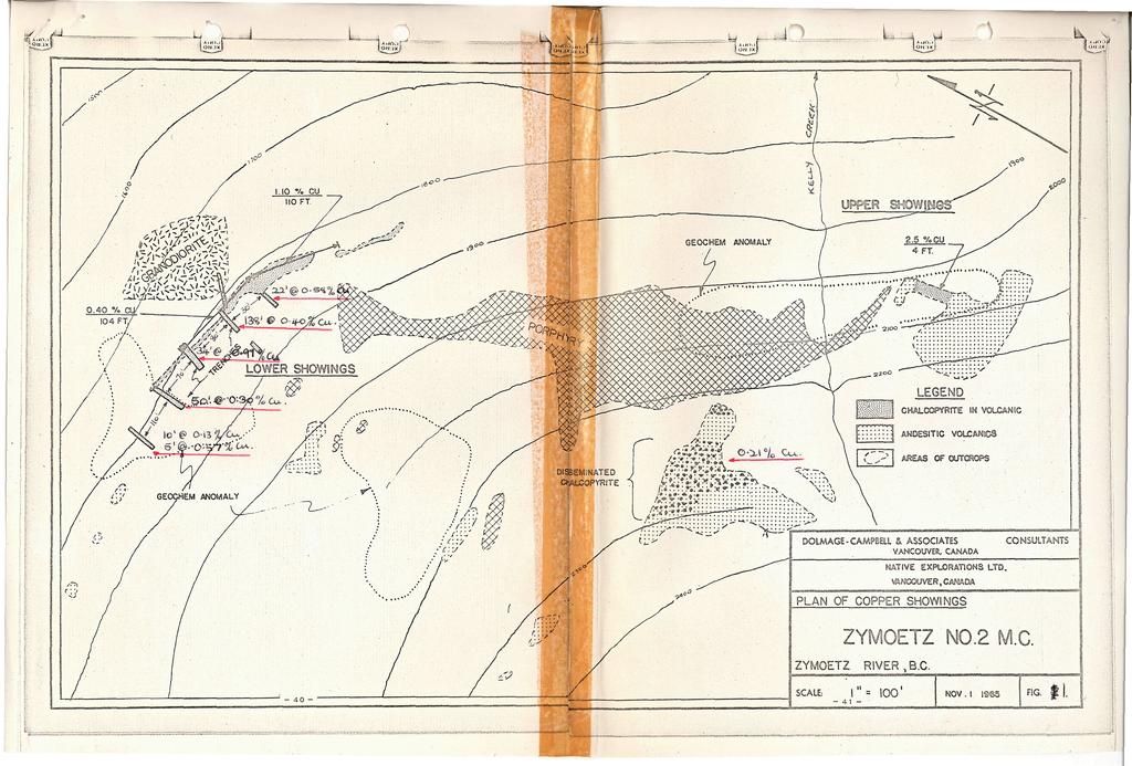
1 NATIVE EXPLORATIONS LTD. A PRELIMINARY REPORT ON THE ZYMOST2 CLAIM GROtP, TERRACE, B.C. INTRODUCTION': The Zymoetz claim group is, at present, held under option by Native Explorations Ltd.. On the 19th day of June, I sampled the Lower and Disseminated Chalcopyrite Showings, and made a brief examination of the rest of the property. The claims are located on a steep hillside, on the south side of the Zymoetz River (sometimes referred to as the Copper River) some 21 miles east of Terrace. Access from the town to the camp is by a good all weather gravel road, and from there up to the showings, approximately 600' vertically, by a road passable only by a four wheel drive vehicle. Attention is drawn to the report on the property by D.D. Campbell,?. Eng., Consulting Geologist for Native Mines Ltd.. GEOLOGY" The Zymoetz group is underlain by Hazelton group volcanics locally intruded by stocks of granodiorite which are evident on the lower elevations of the mountainside. Above this intrusive is a band about 100 feet in width of "intensely potash feldspathized aphanitic and fragmental" andesitic volcanic rocks* The Lower Showings are located here, mineralization, of fine disseminated chalcopyrite, malachite and minor bomite and chalcocite, extending for some 400 feet along the hillside. Above the volcanics is a massive uniform band, 300 feet in thickness, of felspar porphyry, and above this, volcanics similar to those below the porphyry. Disseminated chalcopyrite in these upper volcanics is evident in an outcropping bluff, but extent of this is not known. 5\irther to the east, at the same elevation, on the east side of Kelly Creek more mineralization of chalcopyrite is evident. (Upper Showings) but exposure is poor Some 1,000 feet beyond the Upper Showings to the east, and along
2 Page 2 the general direction of strike, copper staining is reported in a slide, but this was not examined. The volcanics and po.rphory extend along the hillside, striking north west-south east, and dipping southerly into the hillside* SAMPLING: Ten samples were cut in the five trenches on the Lower Showings. The trenches are aligned across the strike of the mineralized zone, but do not all extend completely across the mineralized zone, 7ig. 1 As the trenches were not completely clean, close chip sampling of the bedrock was carried out rather than cutting channel samples. However, it is felt that the samples are representative. Assays were as follows;- Length i Cu. Trench No. 1 22? 0.58 Trench No ' ).& Trench No. 2 6o»-96' 0.46 Trench No. 2 96»-l38' 0.13 Trench No ' 0.46 Trench No. 3 l6'-34«1.30 Trench No ' 0.33 Trench No. 4 25'-50' 0.2? Trench No ' 0.13 Trenching not Trench No. 5 36'-41' 0.57 completed. This gives an average grade of 0.45^ Cu. for a length oi and average width of 56*, or 1,620 tons/vertical foot. A spot sample was also taken on the Disseminated Chalcopyrite Showing which gave 0.21$ Cu., over an area 70' x 30*o CONCLUSIONS AND RECOMMENDATIONS; The sampling of the Lower Showings does not confirm the reported. 1.10$ Cu. assay obtained over 110', although this latter was obtained by sampling along the strike. The average width of 5^ is araeancalculated from trench lengths, and not meant as an average width for the mineralized zone. The extent of the mineralization is, as yet, unknown, but three geochemical anomalies seem to indicate that it is more extensive than at present revealed by the outcrops. An I. p. survey now in
3 Page 3 progress may help to delineate these anomalies. A diamond drill was moved onto the property on the 20th of June. The first hole to be drilled below the Lower Showings, should intersect the granodiorite, volcanics and porphory and give some better indication as to thickness and grade of the mineralised band, Until more information is available of both the drill results!? survey it is recommended that no further action be taken, Respectfully submitted June. 23, 1966 I.A.C. Turnbull.
4

5 ffln NATIVE M.iMES LIMITED FOR THE INFORMATION OF SHAREHOLDERS FOR FURTHER INFORMATION CONTACT: WAITE REID & CO. LTD. 562 HOWE ST. VANCOUVER B.C. TELEPHONE

6 ^n NATIVE M..\IES LIMITED FOR THE INFORMATION OF SHAREHOLDERS 1 \ *»*»' */mf>'aa a ofte zot*e one zo*f High grade ore was encountered at the 1 20 E raise on the "B'' zone. Values at 36" wide were Gold.01 oz., silver ozs., lead 22.30% and zinc 22.90%. Nat/ve Mmes ItJ. CLAIM MAP Apr,/ /5, /966 + NATIVE MINES LTD. DEVELOPMENT PLAN - Stitftk ***** T*»?***Y April IS, /<?66 A OftS A/on A' ZOA/t Atoms FOR FURTHER INFORMATION CONTACT: WAITE, REID 4 CO. LTD. 562 HOWE ST. VANCOUVER B.C. TELEPHONE

7 Tot Cyprus. Mines...Corporation 822 " 5-10-West Hastings Street Vancouver-j-B-iG-b (Eerttftrate of AHBag COAST ELDRIDGE ENGINEERS & CHEMISTS LTD. ACCT1C 9 Membei Caniflian T«ing Assooilion PHONE: CABLE ADDRESS "ELORICO" FILE NO. A.3-C DATE June 29, EAST 4TH AVE. VANCOUVER 10. CANADA We Unebij (tettfjj that the following are the results of assay s made by us up on submitted... Ore sambles GOLD SILVER Copper (Cu) MARKED OUNCES VALUE OUNCES PER PER PER PER PER PER PER TON PER TON PER TON CENT. CENT. CENT. CENT. CENT. CENT s 0o o o 21 /jp Gold calculated at $. per ounce Note. Rejects retained one week. Pulps retaine'd one month. Pulps and rejects may be stored for a maximum of one year by special arrangement. Unless it is specifically stated otherwise, gold and silver values reported on these sheets have not been adjusted to compensate for losses and gains inherent in the fire assay process. Provincial Assayer

8 ^/, i/i^ jj&fo 2/ 3aSo3 3o*>& *^ - 3a So-S 3o*>~o 6 3ajo7 5o*Q* So go? Bo /o oj/t - * / ^.y^ *T /& M. II.43 2^> - ( So /s 2^ XZ 2s/ 4& 3&- 10 ' ^Y^>>. ^f($)

9 CrO - 2 / ^ * ^"4, *r ' /( >2- > /ou^ /IfMj&jJl f /o ^4n/Vr / *" <fas 1u a-*jfc^..
41,a* h0.iiii*bll*i2l,i DEADWOOD CREEK. for. James R. on the BOMBINI GROUP OF CLAIMS. GREENWOOD, British Columbia. Lat. 49'07' Long. 118'43 f.
 GEOLOGCAL REPORT on the BOMBN GROUP OF CLAMS DEADWOOD CREEK GREENWOOD, British Columbia Lat. 49'07' Long. 118'43 f in the GREENWOOD MNNG DVSON for FURY EXPLORATONS LTD. (N. P. L. ) Vancouver, B. C. December
HOWE COPPER MINE PROJECT HIGH GRADE Cu-Ag with Au
 HOWE COPPER MINE PROJECT HIGH GRADE Cu-Ag with Au The Howe Copper Mine property is located approximately 55 kilometres northwest of Vancouver, BC. It is situated at 1431 metres elevation on the eastern
The Cobalt Rainbow. Airborne geophysical maps show that a north trending aeromagnetic high suggests further undiscovered mineralisation.
 The Cobalt Rainbow The property is located on Greenstone Creek, approximately 4.8 kilometres south west of the creek mouth. The property is located about 24 km due west of Campbell River, in the east-central
FIRST 2 DRILL HOLES AT NAKRU-2 PROSPECT BOTH INTERSECT SIGNIFICANT HIGHER GRADE COPPER MINERALISATION
 ADDRESS PHONE PO Box 6965 +61(07) 5592 1001 Gold Coast Mail Centre FAX Qld 9726 Australia +61 (07) 5592 1011 EMAIL ABN 54 126 490 855 info@coppermoly.com.au WEBSITE www.coppermoly.com.au ASX Announcement
GEOLOGICAL BRANCH ASSESSMENT REPORT 12. FItE NO: ACTION: THE GOLDEN MINING DIVISION, GOLDEN, Including THE NTS MAP; M82K/15W
 ACTION: FItE NO: Including 1990 GEO-CHEM SURVEY RESULTS -- THE AVD CLAIMS - THE GOLDEN MINING DIVISION, GOLDEN, B.C. NTS MAP; M82K/15W Lat. 50 deg. 55 Min. Long 116 deg. 55 min. For GEOLOGICAL BRANCH ASSESSMENT
For personal use only
 ANNOUNCEMENT TO THE AUSTRALIAN SECURITIES EXCHANGE: 28 NOVEMBER 2012 DRILLING UPDATE MABILO PROJECT The Directors of Sierra Mining Limited ( Sierra ) are pleased to announce further results from reconnaissance
Haoma Mining NL A.B.N
 Haoma Mining NL A.B.N 12 008 676 177 Registered Office & Head Office: 411 Collins Street, Melbourne, Vic., 3000, GPO Box 2282U, Melbourne, Vic., 3001. Telephone (03) 9629 6888, Facsimile (03) 9629 1250
MINCOR /GOLDEN RIM FIJI JOINT VENTURE SIGNIFICANT NEW EXPLORATION RESULTS
 1 November 2007 MINCOR /GOLDEN RIM FIJI JOINT VENTURE SIGNIFICANT NEW EXPLORATION RESULTS Highlights Very high gold-in-soil sample results up to 17.3 g/t gold have been received from the Banana Creek Prospect.
Amador Canyon Silver Mining Property Lander County, NV
 Amador Canyon Silver Mining Property Lander County, NV Over $1 million worth of exploration and evaluation work performed Favorable drill results including a return of 286 g/ton silver over 12.2 meters
DSM SYNDICATE DISCOVERS POLYMETALLIC MINERALIZATION WITH TALUS GRAB SAMPLES CONTAINING UP TO PERCENT LEAD AND 18
 DSM SYNDICATE DISCOVERS POLYMETALLIC MINERALIZATION WITH TALUS GRAB SAMPLES CONTAINING UP TO 92.8 GRAMS PER TONNE GOLD, 13,643 GRAMS PER TONNE SILVER, 13.85 PERCENT LEAD AND 18.65 PERCENT COPPER FROM DIFFERENT
GEOCHEMICAL REPORT ON THE YEP CLAIMS, Clinton Mining Division. P.E. Fox, PhD. P.Eng.
 CLNTON 1 MNNG RECORDER GEOCHEMCAL REPORT ON THE YEP CLAMS, Clinton Mining Division P.E. Fox, PhD. P.Eng. Fox Geological Consultants Ltd 204-635 Victoria St. Kamloops, B. C. August 5, 1974 Work done: Juge
The survey covered claims, in part or in full, DUCKLING 3, 4, 5, 4 fraction, and 5 fraction.
 514 687-6671 XXX- 602 West Hastin~a StroeP, Vata;sn@ouver, BritlsA fhlum~b~a, Garaadsa B81apphgtaa DISCUSS ION OF MAGNETOMETER SURVEY ON DUCKLING CLAIMS FOR DONNA MINES LTD. (N0P.L.) Submitted to: DONNA
ORO GOLD COMPLETES 1200-METRE DRILL CAMPAIGN AT CIMARRON GOLD PROJECT IN ROSARIO MINING DISTRICT, MEXICO
 ORO GOLD COMPLETES 1200-METRE DRILL CAMPAIGN AT CIMARRON GOLD PROJECT IN ROSARIO MINING DISTRICT, MEXICO October 20, 2010 Oro Gold Resources Ltd. ( Oro Gold ) (TSX-V: OGR) reports completion of a 14-hole,
Geo chemi c a1 Rep or t SILVER KING FAST GROUP. H. S. Lazenby Geologist. Vancouver, B.C. 16 November 1967
 Geo chemi c a1 Rep or t on SILVER KING FAST GROUP 1967 Vancouver, B.C. 16 November 1967 H. S. Lazenby Geologist Contents Introduction P. 1 Method of Survey P. 1 Interpretation of Results p. L&2 Statement
compietea since tnat date, and wnicn comprisea btage I ot tne recommended
 compietea since tnat date, and wnicn comprisea btage I ot tne recommended four-stage program. GEOLOGY & MINERALIZATION The property situate6 on the southeast slope of Nickel Plate Mtn., and within the
for the Greenwood Mining Division, B.C. NTS 82E/7W Latitude 49' 27' W, Longitude 118' 5 Prepared by a= D. Dylan Watt, B.Sc.
 t. b LOGnO: 37~ -08 m. ACTIO#: for the AMP AMP 2 AMP 3 t AMP 4 CLAIMS Greenwood Mining Division, B.C. NTS 82E/7W Latitude 49' 27' W, Longitude 8' 5 %E c,w zc *& a w Prepared by a= -4c. D. Dylan Watt, B.Sc.
DISCOVERY OF MINERALISED PORPHYRY & MAGNETITE-COPPER-GOLD AT KAMARANGAN
 MEDUSA MINING LIMITED ABN: 60 099 377 849 Unit 7, 11 Preston Street Como WA 6152 PO Box 860 Canning Bridge WA 6153 Telephone: +618-9367 0601 Facsimile: +618-9367 0602 Email: admin@medusamining.com.au Internet:
Goliath Reports Grams Per Tonne Gold Equivalent Over 2 Metres Channel Cut at Golddigger in the Golden Triangle; Bulk Sample Recommended
 Goliath Reports 22.83 Grams Per Tonne Gold Equivalent Over 2 Metres Channel Cut at Golddigger in the Golden Triangle; Bulk Sample Recommended November 28, 2017 Goliath Resources Ltd. (TSX-V: GOT) (the
---.,- A.S. ASH'TON, P. ENG. Delta, B.C. REPORT AMORE GROUP VICTORIA MINING DIVISION 32 KM S.S.W. OF NANAIMO, B.C. N.T.S.
 REPORT ON AMORE GROUP VICTORIA MINING DIVISION 32 KM S.S.W. OF NANAIMO, B.C. LATITUDE 48O57' N LONGITUDE 124O18' W N.T.S. 92C/16 W FOR AQUARIUS RESOURCES LTD. 11450-124 Street, Edmonton, Alberta. T5M OK3
For personal use only
 INTEGRATED RESOURCES GROUP LIMITED REPORT ON ACTIVITIES, MARCH 2012 QUARTER HIGHLIGHTS Announcement of company transforming Maryborough Basin project acquisition, expected to be completed in June 2012.
PROSPECTING REPORT THE WALLACE CLAIM OMENICA MINING DIVISION. 54" x6" 3.d d. for. Reako Exlorat ions Ltd. Wallace Rev. C.G.
 PROSPECTING REPORT ON THE WALLACE CLAIM OMENICA MINING DIVISION 54"44 14 1x6" 3.d d by David A. Howard P.Eng. for Reako Exlorat ions Ltd. Claim Locat ion Wallace Rev. C.G. #1560 Dome Mountain Area 9 3
PROSPECTORS ASSISTANCE PROGRAM MINISTRY OF ENERGY AND MINES
 BRITISH COLUMBIA PROSPECTORS ASSISTANCE PROGRAM MINISTRY OF ENERGY AND MINES GEOLOGICAL SURVEY BRANCH PROGRAM YEAR: 1999/2000 REPORT #: PAP 99-l 6 NAME: KIM ANSCHETZ PROSPECTORS TlEPORT on the 99 LOUIS
PERCUSSION DRILLING REPORT ON THE MARA #1 CLAIM. Sirnilkameen Mining Division, B.C. for
 PERCUSSION DRILLING REPORT ON THE MARA #1 CLAIM Sirnilkameen Mining Division, B.C. for PARA MINERALS ti OILS INC. 770 McFarlane Tower, 700-4th Avenue S.W. Calgary, Alberta T2P 354 J.P. ELWELL, P. Eng.
LUCKY BEN MINE PROJECT SEPTEMBER 2018 UPDATE
 LUCKY BEN MINE PROJECT SEPTEMBER 2018 UPDATE During the first week of July 2018 work was completed by our Geologist, Richard Morris, and support personnel to stake the Lucky Ben vein structure at surface
cpw 6. E. Spencer Engineering Ltd. HANNA 9 M. C. 104 REP 0 RT DIAMOND DRILLING PROGRAMME LIARD MINING DISTRICT, K.T.S. FOR TAURUS RESOURCES LTD.
 6. E. Spencer Engineering Ltd. LlJ REP 0 RT ON DAMOND DRLLNG PROGRAMME cpw HANNA 9 M. C. LARD MNNG DSTRCT, K.T.S. 104 P@g FOR TAURUS RESOURCES LTD. BY B. E. SPENCER, P. ENG. B. E. SPENCER ENGNEERNG LTD.
THE PROPERTIES of. JSR1CH0 HIKES LTD. and GAZA MIH1SS LTD, HIGHLAND VALLiSY, BRITISH COLUMBIA. for ALWIN MINING COMPAKY LTD.
 BACON & CROWHURST LTD. on THE PROPERTIES of JSR1CH0 HIKES LTD. and GAZA MIH1SS LTD, HIGHLAND VALLiSY, BRITISH COLUMBIA for ALWIN MINING COMPAKY LTD. by R.W. PHENULER, B.Sc., P.Eng. Vancouver, B.C July
For personal use only
 ASX RELEASE 13 July 2012 ASX Code: PMQ Encouraging Field Exploration Results: Mount Borium Gold Project Key Points Third phase of field exploration underway the Company has been highly active since the
2013 GEOLOGICAL ASSESSMENT REPORT SHERIDAN HILL PROPERTY
 2013 GEOLOGICAL ASSESSMENT REPORT ON THE SHERIDAN HILL PROPERTY NEW WESTMINSTER MINING DIVISION BRITISH COLUMBIA NTS 092G07 49 16 31 NORTH LATITUDE, 122 39 48 WEST LONGITUDE PREPARED FOR Sheridan Hill
UNION MINIERE EXPLORATIONS AND MINING CORPORATION LIMITED ASSESSMENT REPORT ON FITINAT MINERAL CLAIM. Alberni Mining Division Record No.
 M F )( UNION MINIERE EXPLORATIONS AND MINING CORPORATION LIMITED Suite 200, 4299 Canada Way, Burnaby, B.C. V5G 1 H4 Telephone (604) 437-9491 ASSESSMENT REPORT ON GEOCHEMICAL SOIL SURVEYS AND ROCKSAMPLING
SUPPLEMENT TO MAGNETOMETER 6 ELECTROMAGNETIC SURVEY REPORT. DATED NOVEMBER l, 1973 CIGLEN INVESTMENTS LIMITED CLAIMS GROUP BAD VERMILLION LAKE AREA
 ^ A R l ^ 1974 010 PROJECTS UNIT SUPPLEMENT TO MAGNETOMETER 6 ELECTROMAGNETIC SURVEY REPORT DATED NOVEMBER l, 1973 CIGLEN INVESTMENTS LIMITED CLAIMS GROUP BAD VERMILLION LAKE AREA DISTRICT OF RAINY RIVER
American Creek Resources is a precious metals exploration company with an impressive portfolio of high-potential gold
 American Creek Resources is a precious metals exploration company with an impressive portfolio of high-potential gold and silver projects in British Columbia. These include properties in B.C.'s prolific
Introducti on. Land Survey. Geomagnetic Survey. Geomagnetic Results and Interpretati ons - Conclusions and Recommendations C
 m M 42A86SW8281 63.42 PRICE 010 C O H T E H l 42A86SW828I 63.42 PRICE 010C Introducti on Land Survey Geomagnetic Survey Geomagnetic Results and Interpretati ons - Conclusions and Recommendations - - -
BRY PLACER GROUP. Assessment Report Gravel,silt sampling and panning on. Claims: , , Located on map sheet 093A 062
 BRY PLACER GROUP Assessment Report 2012 Gravel,silt sampling and panning on Claims: 523068, 522278, 589718 Located on map sheet 093A 062 5~2 57'3/A/ / 31 Hi' 9 " )Aj Cariboo D/viS''on Owner-operator Egil
SIMUKU DRILLING TO OVER 1000 METRES DEMONSTRATES SIGNIFICANTLY INCREASED TONNAGE POTENTIAL OF THE INFERRED RESOURCE
 ADDRESS PHONE PO Box 6965 +61(07) 5592 1001 Gold Coast Mail Centre FAX Qld 9726 Australia +61 (07) 5592 1011 EMAIL ABN 54 126 490 855 info@coppermoly.com.au WEBSITE www.coppermoly.com.au ASX Announcement
I PRELIMINARY MAGNETOMETER SURVEY
 .REPORT O N I PRELIMINARY MAGNETOMETER SURVEY and GEOLOGICAL RECONNAISSANCE L AND K GROUP OF CLAIMS Located 8 Miles East of Princeton, B. C. Similkameen Mining Division Lat. 49' 27' N. Long. 120' 16' W
Canadian National Railways tracks from the foot bridge across the. Thompson River from the Trans Canada Highway. A pick-up truck was used
 Canadian National Railways tracks from the foot bridge across the Thompson River from the Trans Canada Highway. A pick-up truck was used on the highway side and a h-wheel drive Jeep was transported by
Tameapa Regional Geology
 Tameapa Project 1 Tameapa Regional Geology History San Francisco Mines of Mexico Ltd. (San Francisco), which completed an exploration program, including six drill holes (1,157 m) between 1956 and 1959.
CSA Mine Observations Applied to the Development of Regional Exploration Models
 CSA Mine Observations Applied to the Development of Regional Exploration Models 1 Introduction Recent work completed by the geology team has resulted in an improved understanding of the CSA mine system
GEOLOGICAL MAPPING REPORT ON THE ASH MINERAL CLAIM OSOYOOS MINING DIVISION ASHNOLA RIVER MAP SHEET NTS M092,H019 MCBRIDE CREEK AREA, ASHNOLA RIVER,
 GEOLOGICAL MAPPING REPORT ON THE ASH MINERAL CLAIM OSOYOOS MINING DIVISION ASHNOLA RIVER MAP SHEET NTS M092,H019 LATITUDE 49 o O6, LONGITUDE 120 o 22 MCBRIDE CREEK AREA, ASHNOLA RIVER, KEREMEOS, B.C. CANADA
FIRST YEAR ASSESSMENT REPORT PROSPECTING LICENCE 16512M MARYSTOWN AREA, BURIN PENINSULA NTS 1M/3
 FIRST YEAR ASSESSMENT REPORT OF PROSPECTING ON LICENCE 16512M MARYSTOWN AREA, BURIN PENINSULA NTS 1M/3 BY NATHANIEL NOEL MSc. FOR E. MICHELE NOEL MINERAL LICENCES: 16512 M WORK CONDUCTED: MID-SEPTEMBER
on the Diamond Drilling done on the LAKESIOE GROUP of Mineral Claims SLOCAN MINING DIVISION 82-F-14-W Long ' Lat '
 Assessment Work Report on the Diamond Drilling done on the LAKESIOE GROUP of Mineral Claims SLOCAN MINING DIVISION 82-F-14-W Long 117 22' Lat. 49 58' ADRIAN KESLER SILVERTON, B.C. operator LEVON RESOURCES
SAMPLE ID SAMPLE TYPE Au (g/t) Ag (g/t) Cu (%) AuEq**(g/t)
 Ag (g/t) Cu (%) AuEq**(g/t)") GOLDEN RIDGE RESOURCES DISCOVERS NEW ALKALIC CU-AU PORPHYRY TARGET ON ITS HANK PROJECT Kelowna, British Columbia November 22,2017 - Golden Ridge Resources Ltd. ( Golden Ridge or the Company ) (TSXV: GLDN).
GOLDEN RIDGE RESOURCES DISCOVERS NEW ALKALIC CU-AU PORPHYRY TARGET ON ITS HANK PROJECT Kelowna, British Columbia November 22,2017 - Golden Ridge Resources Ltd. ( Golden Ridge or the Company ) (TSXV: GLDN).
Drilling Commences at Telfer West Gold Project
 Level 7, 600 Murray Street West Perth WA 6005 PO Box 273 West Perth WA 6872 P 08 9486 9455 F 08 6210 1578 www.enrl.com.au 17 November 2016 ASX : ENR Company Announcements Office Australian Securities Exchange
NEWS RELEASE. Empire Mining Corporation 1090 Hamilton Street Vancouver, B.C. V6B 2R9
 Empire Mining Corporation 1090 Hamilton Street Vancouver, B.C. V6B 2R9 Phone: (604) 634-0970 Fax: (604) 634-0971 Toll Free: 1 888 818-1364 info@empireminingcorp.com www.empireminingcorp.com NEWS RELEASE
3 I1 I I Ill 111 II! II 111 II Ill I IlE I I P I
 -7 3 1 1 11111111111111111111111111111111 ll 111! 111 111 111 111 111111111111111 ll 1111111 1 11111111111111 le P GEOCHEMCAL SURVEY OF THE KE AND D'ARCY CLAM GROUPS.. Similkameen Mining Division, B.C.
The MAPLE BAY PROJECT Copper Silver - Gold
 The MAPLE BAY PROJECT Copper Silver - Gold Good grade and tonnage potential within close proximity to Tidewater The Maple Bay Copper Silver Gold Project covers highly favourable geological host rocks of
ASX Announcement. 28 January Drill results indicate large Porphyry Copper Gold System at Peenam
 ASX Announcement 28 January 2010 Drill results indicate large Porphyry Copper Gold System at Peenam Highlights: 270 metres of visible copper (gold) mineralisation in first diamond core hole at Peenam Prospect
DIANOND DRILLING REPORT. NICOLA MINING DIVISION, B.C. Lat 'N, Long. 12O03O'W N.T.S. Map 921/1 W82E. for
 W DIANOND DRILLING REPORT MM #1, MM #2, MM #3, INEZ #1, INEZ #2, AND CROWN GRANTED CLAIMS NICOLA MINING DIVISION, B.C. Lat. 50 10'N, Long. 12O03O'W N.T.S. Map 921/1 W82E for FLAIR RESOURCES LTD. 1417-409
NEWS RELEASE July 26, 2018
 NEWS RELEASE July 26, 2018 Ashanti Broadens Main Zone at Gourbassi East, Kossanto East Project, Mali 48m of 1.34 g/t gold (including 3m of 3.57 g/t gold) and 34m of 1.80 g/t gold (including 4m of 8.48
GIANT MASCOT MINES LIMITED ~nen~z~s~11~uumsn~ SURRARD STREET VANCOUVER 1, B. C. June 4, 1968
 NtNI OFFICE; P. 0. BOX 820. HOPE. 8. C. TELEP*ON
12 tons of high-grade ore was mined from the No. 1 vein with an average grade of 13 g/t gold, 3,250 g/t silver and 23.3% lead.
 DUNWELL MINE GROUP The Dunwell Mine Group (Dunwell, Dunwell East, Bear River/MM and Silvershot properties), which includes the historic, past-producing Dunwell mine, is located 8 km northeast of Stewart
A New Direction. Copper-Gold Deposit at Thor TSX.V:COL. August 11, May 2013
 A New Direction Copper-Gold Deposit at Thor August 11, 2016 May 2013 TSX.V:COL FORWARD LOOKING STATEMENTS This presentation includes certain forward-looking information or forward-looking statements for
..!I AXE CLAIMS ON THE. for RICHCORE EXPLORATIONS LTO. GREENWOOD MINING DIVISION BRITISH COLUMBIA. Latitude 49O 30"; Longitude 118' 30'W NTS 82E/9W
 ON THE AXE CLAIMS for RICHCORE EXPLORATIONS LTO. GREENWOOD MINING DIVISION BRITISH COLUMBIA Latitude 49O 30"; Longitude 118' 30'W NTS 82E/9W... -... ~ i.,...._.'..!i Vancouver, B.C. September, 1980 P.
For personal use only
 JUNE 2011 QUARTERLY ACTIVITIES REPORT ASX Release 29 July 2011 LINDIAN RESOURCES LIMITED Level 1 / 33 Richardson Street West Perth, Australia WA 6872 Tel: +61 8 9200 4438 Fax: +61 8 9200 4469 Contact:
lat ' N Long ' W
 305 7 ec1;, REPORT ON THE JERY CLAIMS OF POLA RESOURCES LTD. NTS 93L/16 0 0 lat. 54 45' N Long. 126 22' W BABIXE LAKE AREA OMINECA MINING DIVISION, B.C. PAUL PLICKA CONSULTING GEOLOGIST DECEMBER 30, 1981
NEWS RELEASE. Evrim announces initial drilling results at Cuale Gold Project in Mexico
 910-850 WEST HASTINGS ST. VANCOUVER, BC, CANADA V6C 1E1 TEL: 604.248.8648 FAX: 604.248.8663 WWW.EVRIMRESOURCES.COM TSX-V: EVM CONTACT: PADDY NICOL OR CHARLES FUNK NEWS RELEASE Evrim announces initial drilling
PROSPECTING REPORT. Medallion Property. EVENT # TENURE # Tenure Name: GPEX CLVIII Medallion
 2006-2007 PROSPECTING REPORT Medallion Property EVENT # 4167980 TENURE # 540362 Tenure Name: GPEX CLVIII Medallion Watson Bar Region Clinton Mining Division Map 092O Central Coordinate Reference Long.
GEOLOGICAL BRAN ASSESS
 TITLE PAGE This report covers assessment work performed on the Mundy group, located in the Boundary Creek area, north of Greenwood, British Columbia. The work comprises of THM soil testing, trenching and
Narrow High-Grade Gold and Long Low-Grade Porphyry Gold and Copper-Gold Intercepts at Bulago
 CONTACTS PHONE EMAIL PO Box 52 +61 (08) 9295 0388 info@frontierresources.com.au West Perth FAX WEBSITE WA 6872 Australia +61 (08) 9295 3480 www.frontierresources.com.au ASX Limited Company Announcements
EXPLOR INTERSECTS MULTIPLE COPPER ZONES GRADES UP TO 3.65% CU OVER 5.35 METERS ON THE CHESTER COPPER PROPERTY
 15 Gamble East Street - Suite 204 - Rouyn-Noranda (Canada) J9X 3B6 Listing (TSX-V = EXS) (OTCQB = EXSFF) (FSE & BE = E1H1) EXPLOR INTERSECTS MULTIPLE COPPER ZONES GRADES UP TO 3.65% CU OVER 5.35 METERS
4. Geological maps published by the Ontario Department of Mines.
 52J08NWei45 S2J08NWa6B1 SMYE 010 AMALGAMATED RARE EARTH MINES LTD. *, SAVANT LAKE PROSPECT x ONTARIO INTRODUCTION t This Is a report on a group of 28 claims control led by Amalgamated Rare Earth Mines
INTRODUCTION ASHLU GROUP. The Ashlu Group is located in the Vancouver Mining Division on
 ; - ( NTRODUCTON ASHLU GROUP The Ashlu Group is located in the Vancouver Mining Division on 8 r ---- n --.. 2 3 120. ', -.. -.- P A C / F / C -- OCEAN -..-.. -.. -. FG. No. 1 REGONAL LOCATON MAP ASHLU
NEWS RELEASE August 8, 2018
 NEWS RELEASE August 8, 2018 Ashanti continues to Expand Main Zone at Gourbassi East, Kossanto East Project, Mali 20m of 2.32 g/t gold (including 6m of 6.80 g/t gold) VANCOUVER, BC August 8, 2018 Ashanti
Mountain Maid Gold System Displays Major Size Potential
 29 July 2008 The Manager, Companies Australian Securities Exchange Ltd Electronic Announcement System Dear Sir, AXIOM MINING LIMITED (ASX CODE: AVQ) ASX Announcement Mountain Maid Gold System Displays
Gold-Silver-Copper-Zinc Exploration in Mexico and British Columbia, Canada
 Gold-Silver-Copper-Zinc Exploration in Mexico and British Columbia, Canada Corporate Presentation January 2011 Forward-looking Statements This presentation contains certain statements that may be deemed
Summary of Rover Metals Geologic Mapping Program at the Up Town Gold Project, Northwest Territories
 October 13, 2017 Summary of Rover Metals Geologic Mapping Program at the Up Town Gold Project, Northwest Territories Vancouver, British Columbia, Canada - Rover Metals Corp., Rover, is pleased to provide
27 metres Grading 66.8 g/t Gold and
 ADDRESS PHONE EMAIL PO Box 35 +61 (8) 9295 0388 info@frontierresources.com.au North Perth FAX WEBSITE WA 6906 Australia +61 (8) 9295 3480 www.frontierresources.com.au ASX Limited Company Announcements
For personal use only
 ASX ANNOUNCEMENT 31 August 2012 DRILLING SUCCESS CONTINUES AT GUCHAB Near surface copper mineralisation in drill core from GCDD0002 HIGHLIGHTS The pilot programme of diamond drilling at Guchab continues
Elverdton Copper-Gold Project Ravensthorpe, Western Australia
 FOR SALE or JV Elverdton Copper-Gold Project Ravensthorpe, Western Australia Summary: The Elverdton Copper-Gold Project is located approximately 11 kilometres south-east of Ravensthorpe town, which is
CONTENTS. Location, Access and History...6. Tenure Status and Geology Regional Andy Property Geology Map...9
 TYPE OFWORK IN THIS REPORT EXTENT OF WORK (rn METRTC UNITS) ON WHICH CLAIMS PROJECT COSTS APPORTIONED (incl. support) GEOLOGICAL (scale, area) Ground, mapping Photo interpretation GEOPHYSICAL (line-kilometres)
For personal use only
 13 October 2011 ASX Announcement MOD TO EXPLORE NEW ZEALAND S LARGEST UNDEVELOPED GOLD RESOURCE (ASX: MOD) MOD to earn up to 80% of New Zealand s largest undeveloped gold resource, Sams Creek Sams Creek
NEW COBAR-STYLE COPPER DISCOVERY IN NSW
 ASX / MEDIA RELEASE 2 AUGUST 2011 NEW COBAR-STYLE COPPER DISCOVERY IN NSW Broad zone of copper-polymetallic mineralisation intersected at 4-Mile prospect Highlights: Wide zone of copper-silver-gold-lead-zinc
%+ '$# $) %, %*$ " $ $ ' %' !()'-!" %( %"%! " *'+ - % %$! $)! " $)!" !$ ' "! )( ! $ '%& ')- % % "!#( (( ((# $) ' ) ((* & *# ' % %"*# ( !!
 %, %*$ $ $ ' %' !()'-! %( %%! *'+ - % %$! $)! $)! !$ ' ! )( ! $ '%& ')- % % !#( (( ((# $) ' ) ((* & *# ' % %*# ( !!") 001L/14/0218 First Year Assessment Report of Prospecting, Rock and Stream Sediment Sampling On Licence 18880M, NTS 1L/14 Burin Peninsula Newfoundland and Labrador Submitted by: Keith Kelloway Work year:
001L/14/0218 First Year Assessment Report of Prospecting, Rock and Stream Sediment Sampling On Licence 18880M, NTS 1L/14 Burin Peninsula Newfoundland and Labrador Submitted by: Keith Kelloway Work year:
ASSESShAENT REPORT Mines and Petroleum Resources. Department of. No* JIMMY MINERAL CLAIM FRANKLIN CREEK AREA, GREENWOOD M. D.
 GEOCHEMICAL REPORT ON JIMMY MINERAL CLAIM FRANKLIN CREEK AREA, GREENWOOD M. D. Lat. 49'35' OON, N.T.S. Long. 118O22' 00W 82-E-9 July 18-21, 1974 Vancouver, B.C. J.J. McDougall, P.Eng. July 21, 1974 * Department
LINGIG PORPHYRY COPPER DISCOVERY
 MEDUSA MINING LIMITED ABN: 60 099 377 849 Unit 7, 11 Preston Street Como WA 6152 PO Box 860 Canning Bridge WA 6153 Telephone: 618-9367 0601 Facsimile: 618-9367 0602 Email: admin@medusamining.com.au Internet:
CONSULTING GEOLOGICAL & MINING ENGINEERS 1000 GUINNESS TOWER VANCOUVER I, B.C. GEOCHEMICAL AND GEOLOGICAL RE PORT
 DOLMAGE CAMPBELL & ASSOCIATES LTD. CONSULTING GEOLOGICAL & MINING ENGINEERS 1000 GUINNESS TOWER VANCOUVER I, B.C. GEOCHEMICAL AND GEOLOGICAL RE PORT on RAVEN MINERAL CLAIMS Nos. 1-10 and 17-21 Claim Sheet
Montgomery Bedrock Geology 21d-Gowganda Formation: conglomerate, sandstone, siltstone, argillite
 Work Report 2014 Trenching Montgomery Township G-3303 Claim #4259384,4245818 Sault Ste. Marie Mining Division Michael & Yvon Gagne Montgomery Copper Property 1 P a g e 2 P a g e Montgomery Bedrock Geology
High Grade Gold Intercepts at Bangaba
 20th March 2012 ASX Announcement High Grade Gold Intercepts at Bangaba Level 2, 9 Colin Street West Perth WA 6005 ABN 11 127 171 877 p (08) 9216 1000 f (08) 9481 7939 w www.predictivediscovery.com e info@predictivediscovery.com
Lat. 52' 43' N Long ' W
 &A exploration ltd MINING ENGINEERING GEOLOGY- GEOPHYSICS 4570 HOSKINS ROAD, NORTH VANCOUVER, 6. C. TELEPHONE (804) 985,7921 V7K 2R1 GEOLOGICAL AND GEOCHEMICAL REPORT on the BLUE CLAIMS Cariboo Mining
DRILLING EXPANDS SIGNIFICANT COPPER-GOLD PORPHYRY SYSTEM AT IVANHOE S KHARMAGTAI PROJECT IN MONGOLIA
 For immediate release November 26, 2002 DRILLING EXPANDS SIGNIFICANT COPPER-GOLD PORPHYRY SYSTEM AT IVANHOE S KHARMAGTAI PROJECT IN MONGOLIA ULAANBAATAR, MONGOLIA Ivanhoe Mines Chairman Robert Friedland
For personal use only
 ABN 79 106 879 690 7 October 2011 The Manager Companies ASX Limited 20 Bridge Street SYDNEY NSW 2000 (6 pages by email) Dear Madam, Multiple zones intersected including 123 metres at 0.61 g/t Gold and
... Discovery : Year 1958 Uncertainty: Method : Decouverte: Annee Incertitude: Page/Page 1 of/de 2
 Page/Page 1 of/de 2 Objet localise: Latitude/Latitude: 56O34'35 Longitude/Longitude: 130 41'15. UTM zone/rbgion UTM: 9 UTM North./UTM Nord: 6271294 UTM East./UTM Est: 396328 Mining division/division miniere:
J.D. Mason, Prof. Engineer. Report on the Reconnaissance Magnetometer Survey. Completed for. North American Platinum Corporation Ltd.
 Report on the Reconnaissance Magnetometer Survey Completed for North American Platinum Corporation Ltd. Olivine Mountain Property, Tulameen, B.C. J.D. Mason, Prof. Engineer. November 28, 1967. Certificate
\ 77 - A76i'~ * DIAMOND DRILLING REPORT SKI CLAIMS KAMLOOPS MINING DIVISION, Pd"
 \ 77 - A76i'~ * DIAMOND DRILLING REPORT RE: SKI CLAIMS KAMLOOPS MINING DIVISION, Pd" B.C. REPORT RE: DRILLING Percussion drilling on the optioned SKI property of Wavecom Development Ltd. started on June
n3a 92 C- /.I 4 tr November 6, 1979 J. F. MclNTYRE, P.ENG. CONSU LTlNG MINING ENGl NEER Map #92C-16 TRANS PACIFIC VENTURES LTD.
 TELEPHONE : 5 9 6-1331 J. F. MclNTYRE, P.ENG. CONSU LTlNG MINING ENGl NEER 6466 CAGELDU CRESCENT DELTA, B.C. CANADA TRANS PACIFIC VENTURES LTD. c i. SAMPLING AND GEOPHYSICAL REPORT CAP CLAIM, VICTORIA
ASSESSMENT REPORT. Geochemical and Geological Surveys. on the. Gooch#1-4. Mineral Claims. Omenica Mining District NTS 93L/7W
 f- GEOLOGICAL BRANCH ASSESSMENT REPORT ASSESSMENT REPORT Geochemical and Geological Surveys on the Gooch#1-4 Mineral Claims Omenica Mining District NTS 93L/7W LAT: 54O25'W LONG: 126O26'W Operator: SMD
Copper Reef to Drill Massive Sulphide Targets in Flin Flon
 12 Mitchell Road Tel: (204) 687-3500 Flin Flon, MB, R8A 1N1 CZC.CSE Fax: (204) 687-4762 copperreef.com February 28, 2019. Copper Reef to Drill Massive Sulphide Targets in Flin Flon Copper Reef Mining Corporation
1 NO MAP ASSESSMENT REPORT. Miner and Pstrolwm Resources. Oepartment of GEOLOGICAL REPORT. On Claims: aesver Dam 1 & 2 Colleen 1 &.
 50 76 GEOLOGICAL REPORT On Claims: aesver Dam 1 & 2 Colleen 1 &. 2 v Nanaimo lvrininq Division By: E, Percy Sheppard, P.Eng. Consu 1 ti ng G eo log is t August 6, 1974 Vancouver, E. C. * * * Oepartment
T-1 Mines and Petroleum Resources
 Department of T-1 Mines and Petroleum Resources ASSESSfdEEdT REPORT NO..LC... 7.t... hlap... ... NTRODUCTON Y ' PERSONNEL.... GEOGRAPHY.... Location..... Access... Page 1 Page 2 Page 2 Page 2 Page 2 Topography...
GEOCHEMICAL REPORT ON A SOIL SAMPLING SURVEY OF PORTIONS OF THE KR GROUP OF MINERAL CLAIMS OF PLATEAU METALS LIMITED.
 GEOCHEMICAL REPORT ON A SOIL SAMPLING SURVEY OF PORTIONS OF THE KR GROUP OF MINERAL CLAIMS OF PLATEAU METALS LIMITED By Kol Lovang Christopher Riley, P. Eng., Supervisor c Vancouver, B. c. Work Performed:
New Zone of High Grade Gold Discovered at Balogo
 ASX/Media Announcement 12 November 2013 New Zone of High Grade Gold Discovered at Balogo A broad zone of high grade gold mineralisation (Panga Lodes) has been discovered 600m north of the Netiana Lodes.
POTENTIAL OF THE DONGWE COPPER GOLD PROJECT
 POTENTIAL OF THE DONGWE COPPER GOLD PROJECT By Nathan Sabao, P.Geo. September 2015 1 TABLE OF CONTENTS Page 1.0 EXECUTIVE SUMMARY 1 2.0 LOCATION 2 3.0 ACCESS 2 4.0 GEOLOGY 3 5.0 PREVIOUS DRILLING 5 6.0
OSOYOOS UINING DIVISION. 49% - 20' North Latitude 120% - 05' West Longitude. GOOD HOPE RESOURCES LTD West Hastings Street Vancouver, B. C.
 REPORT ON HORSEFLY PROPERTY DIAMOND DRILLING - 1982 OSOYOOS UINING DIVISION 49% - 20' North Latitude 120% - 05' West Longitude 9 x It/YG FOR GOOD HOPE RESOURCES LTD. 1518-1177 West Hastings Street Vancouver,
Based on the positive 2017 results, the company has expanded the claims block from 9852 hectares to 14,552 hectares.
 JUGGERNAUT DISCOVERS NEW ZONES WITH CHANNEL SAMPLES GRADING.2 GRAMS PER TONNE GOLD EQUIVALENT OVER 4.6 METRES, 6.8 GRAMS PER TONNE GOLD EQUIVALENT OVER 5 METRES, AND 59 GRAMS PER TONNE GOLD EQUIVALENT
SECOND and THIRD YEAR ASSESSMENT REPORT PROSPECTING LICENCE M, ROCK CUT PROPERTY, NTS 1N/12, NEWFOUNDLAND. ROY FRENCH (licence holder )
") SECOND and THIRD YEAR ASSESSMENT REPORT Of PROSPECTING On LICENCE 013704M, ROCK CUT PROPERTY, NTS 1N/12, NEWFOUNDLAND. By ROY FRENCH (licence holder ) Work Conducted: Sept. 17, 2008 Nov. 03, 2009 Total
SECOND and THIRD YEAR ASSESSMENT REPORT Of PROSPECTING On LICENCE 013704M, ROCK CUT PROPERTY, NTS 1N/12, NEWFOUNDLAND. By ROY FRENCH (licence holder ) Work Conducted: Sept. 17, 2008 Nov. 03, 2009 Total
ASSESSMENT REPORT GEOLOGICAL BRANCH. 50' 23 'North. GEOLOGICAL and GEOCHEMICAL SURVEYS ON THE. PUTNAM PROPERTY (Putnam Mineral Claim)
") GEOLOGICAL and GEOCHEMICAL SURVEYS ON THE PUTNAM PROPERTY (Putnam Mineral Claim) VERNON MINING DIVISION, B.C. GEOLOGICAL BRANCH ASSESSMENT REPORT NTS : Latitude: 82L17W 50' 23 'North LOCATION, ACCESS,
GEOLOGICAL and GEOCHEMICAL SURVEYS ON THE PUTNAM PROPERTY (Putnam Mineral Claim) VERNON MINING DIVISION, B.C. GEOLOGICAL BRANCH ASSESSMENT REPORT NTS : Latitude: 82L17W 50' 23 'North LOCATION, ACCESS,
SPUZZUM CREEK AREA PROSPECTING REPORT. on the NTS 92H/12E. Lat. 49" 44' Long. 121" 43' for H.J. Forsyth & J.D.
 PROSPECTING REPORT on the WREN GROUP of MINERAL CLAIMS SPUZZUM CREEK AREA NEW WESTMINSTER MINING DIVISION NTS 92H/12E Lat. 49" 44' Long. 121" 43' for H.J. Forsyth & J.D. Murphy Owners by Jay 0. Murphy,
NTS 93L/9W GEOCHEMICAL AND GEOPHYSICAL REPORT MONA CLAIM OMINICA MINING DIVISION. Lati tude 54036'N; Longitude 'W
 GEOCHEMICAL AND GEOPHYSICAL REPORT ON MONA CLAIM OMINICA MINING DIVISION Lati tude 54036'N; Longitude 126018'W NTS 93L/9W April 1981 Paul Plicka Consulting Geologist LOCATION MAP INTRODUCTION TABLE OF
between F.J. on the 0H)PHYSICAL and GPX)CIiEMICAL SURVEYS of part of the sa.& SSmRT FIVE MILES SOUTH of GREENWOD, B.C. FIELD WORK DONE FOR
PHYSICAL and GPX)CIiEMICAL SURVEYS of part of the sa.& SSmRT FIVE MILES SOUTH of GREENWOD, B.C. FIELD WORK DONE FOR") FRED J. HEMSWORTH MINING ENGINEER 616 CREDIT FONCIER BLDG. 850 WEST HASTINGS STREET VANCOUVER 1, B.C. SSmRT on the 0H)PHYSICAL and GPX)CIiEMICAL SURVEYS of part of the LM-C GRDUP Of MINERAL CIAIN FIVE
FRED J. HEMSWORTH MINING ENGINEER 616 CREDIT FONCIER BLDG. 850 WEST HASTINGS STREET VANCOUVER 1, B.C. SSmRT on the 0H)PHYSICAL and GPX)CIiEMICAL SURVEYS of part of the LM-C GRDUP Of MINERAL CIAIN FIVE
ON TRACK FOR DISCOVERY. January
 ON TRACK FOR DISCOVERY http://dsmsyndicate.ca/ January 2018 1 PROJECT GENERATOR MODEL The DSM syndicate is a project generator focused on original discovery resulting from glacial and snowpack recession.