T-1 Mines and Petroleum Resources
|
|
|
- Allen Webster
- 5 years ago
- Views:
Transcription
1 Department of T-1 Mines and Petroleum Resources ASSESSfdEEdT REPORT NO..LC... 7.t... hlap...
2 ... NTRODUCTON Y ' PERSONNEL.... GEOGRAPHY.... Location..... Access... Page 1 Page 2 Page 2 Page 2 Page 2 Topography... Page 2 Vegetation.... Page 2 Climate... Page 3 HSTORY AND DEVELOPMENT..... Page 3 GEOLOGY.... Page 4 General... Page 4 Property Geology Page 4 Mineraiization.... Page 5 Sampling.... Page 5 F Economics... Page 6 GEOCXEMCAL SURVEY.... Page 6... Survey Performed... Page 6 Survey Equipment and Analysis. Page 6 1 i Xesults... Page 7 CONCLUSON Page 8 / t; LLUSTRATONS: N Location Map 1," = 4 miles g~~eneral Geology 1" = 1 mile Geochemical Survey?$ 7 C op;?er 1" = 500 feet 'fl " Lead 1" = 500 feet r: i " Silver l" = 500 feet 3' i; Molybdenum 1" = 500 i'eet Clzim *Map & Outcrop 5" 7 Geology il' = 300 feet
3 CON CANYON MNES LTD. GEOCHEMCAL AND GEOLOGCAL REPORT BUD CLAM GROUP Atlin Mining Division 59040'N 'Yi NTRODUCTON The property was visited for the first time on the 4th of August, 1969 with R. L. McKamey. A camp was located and accessibility to the claim group was investigated. Between August 9th and September lst, 1969, under the field supervision of R.L. McKamey, 33, 000 feet of control grid line was cut and surveyed on the Bub Claim Group, at a cost of $2, The line-cutting was applied as assessment work in order to keep the LU BUD LLallms n gooa sranalng unnl ucr;oder Between June 20th and July 3rd, 1970, an additional i 44, 600 feet of control grid line was cut and surveyed, under the 1 field supervision of C. B. Rouleau. Soil samples were collected and sent to Vancouver Geochemical Laboratories Ltd. for geo- chemical analysis. 1 i PERSONNEL ( 1970) Supervision: G. Gutrath, P. Eng. - overall supervision on the Bub Group exploration program for Coin Canyon Mines Ltd.....2
4 PERSONNEL (1970) (cont'd) Line Cutters and Soil Sampling: C. B. Rouleau - responsible for line cutting & s oil sampling. C. Gardiner - line cutter. GEOGRAPHY Location: The Bub Claim Group is located in northwestern British Columbia, 12 miles to the northeast of Atlin, B. C. The claims are on the west side of Boulder Creek, approximately three miles to the s outhwes t of the molybdenum property that is presently being drilled by Adanac Mines Ltd. Coordinates of the Bub Claim Group are 59040'W and 'W. < "i Access: Access to the property is by 14 miles of good, all-weather gravel road from Atlin. Atlin is 50 miles from the Alaska Highway and 100 miles from Whitehorse, Yukon. Topography: The claim group is located on a gentle easterly facing slope, stzrting at an elevation of 3500 feet and extending to the ridge at 5000 feet. The topography would not hinder any future road building on the property. Vegetation: The lower slopes, below an elevation of 4000 feet, is
5 GEOGRAPHY (c ont'd) Climate: The average yearly precipitation would be in the range of 20 - inches. Winter snowfall would average four feet. The average temperature for the month of June is 5 1 F' and for January 200F. HSTORY AhTD DEVELOPMENT Boulder Creek was worked for placer gold intermittently from 1899 to The wolframite in the pay gravels was considered a nuisance and was not saved until 1950 when two ship- ments were made that assayed: 46.88% and W03 and ( and 10.75% tin. n 1963, Newmont Mining Corporation of Canada Ltd. optioned 78 claims from Alan Matson, that included the present Bub Claim Group, of Atlin, B. C. Twelve trenches, totalling 3, 360 feet in length, averaging 16l0 wide and 6'0 deep, were bulldozed in the vicinity of the original showings. A very limited / i area was surveyed with an Askania magnetometer. Newmont dropped their option on the property in Cominco in 1964 optioned the property from Alan Matson and packsack-core drilled the mine ralized zones in the trenches. a Five holes were drilled for a total length of feet. One hole was 50 feet long and the other four were all under 20! i U feet in length....4
6 HSTORY AND DEVELOPhENT (cont'd) The most interesting development in this area is on Adanac's Ruby Creek property, located three miles to the northeast of the Bub Group. Drilling has geologically indicated 82, 329, 000 tons grading MoS2. Kerr Addison Mines Ltd. has optioned the Adanac property and has committed themselves to carrying out a feasibi- lity study costing $2, 500, This program is now underway. ' GEOLOGY General: (J. P. Aitkens, 1959, Geological Survey of Canada, Atlin 1 Map Area (104N) Memoir 307). The east side of Atlin Lake is underlain by Cache Creek sediments and related volcanics of Pennsylvannian age. This series has been intruded by small ultrabasic stocks during Pennsylvannian time and by undifferentiated granite rocks (Coast ntrusions ) and alas kite and quartz monzonite intrusives during Jurrassic and Cretaceous times. Property Geology: The claim group is underlain by Cache Creek Group greens tone interbedded with small sections of limes tone and quartzite. 1 On the west side of the claim group there are three small stocks i i 0 of peridotite and meta-diorite. The northeasterly 113 of the claim group is underlain by a large stock of alaskite composition
7 GEOLOGY (Cont'd) Mineralization: Disseminations and irregular massive lenses of pyrrhotite- pyrite with minor amounts of chalcopyrite, tetrahedrite, galena, sphalerite, flourite, cassiterite and scheelite occur in altered talcose basic volcanies and peridotite. Minor molybdenite mineralization has been located in the northerly trench on the Bub Claim #15. S ampling: Mr. L.G. White, P. Eng. in 1962 had a sample from the property spectrographically analyzed. The most interesting values in the samples were for tin (Sn) 2.570, and tungsten (W) copper and silver, and did not appear to consider the tungsten values worth checking. Their assay values were from: trace to i.42% in tin, nil to.257o in copper, nil to 5. 3% in zinc, and trace to 11.4 oz. in silver. Cominco, in 1964, drilled five packsack-drill holes in the area of the trenches that had been sampled by Newmont. The drilling indicated very short mineralized sections that assayed: up / to copper, zinc, tin, and.41% tungsten
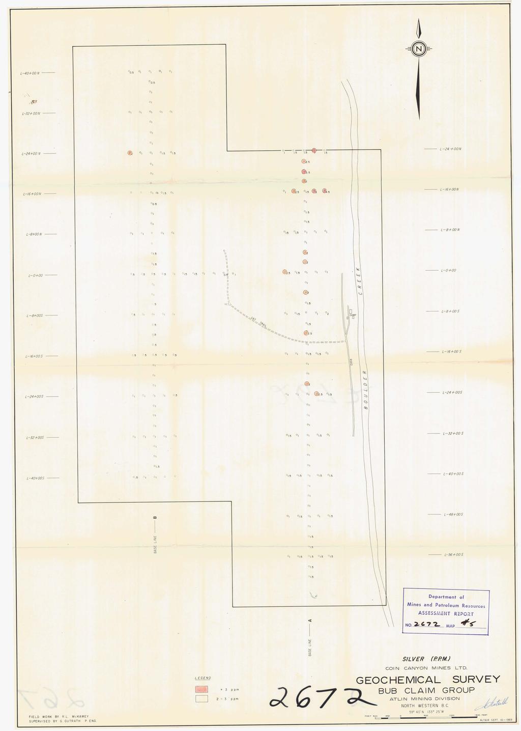
8 GEOLOGY (cont'd) Econo~nics: There has not been enough exploration work done on the property to determine the economic potential. The property is favourably located with regards to water, timber, and trans- portation. There is no electric power available and no local labour force. GEOCHEMCAL SURVEY Survey Equipment and Analysis: The geochemical analysis was done by Vancouver Geo- 0 chemical Laboratories Ltd. using the following equipment and pro- cedure: - Weigth of samples used: 0.5 gm. Samples sifted or ground to: -80 mesh Extraction: Hot HN03 and HC04 Method of Analyses: Atomic Absorption Spectr ometor Volume of Dilution: 10 ml. nstrument used: Tetron AA4 and AA5 Analyst: C. Chung & L. Nicol Analyzed for: : the first 130 samples collected in 1969 were analyzed for Cu, Mo, Pb & Ag. : the 403 samples collected in 1970 were analyzed for Cu. Survey Perfor-med: The soil samples were collected with a stainless steel trowel from the "A" soil horizon at a depth varying from six inches to one foot. A total of 176 soil samples were collected at 200-foot intervals on a grid with crosslines at 800-foot intervals. This was basically 42 a reconnaissance survey to locate the best mineralized zone. area on... 7
9 ....7 GEOC-EMCAL SUXVEY (cont'd) Survey Performed: (cont'd) claim groups. These samples were analyzed for Cu, Mo, Pb and Ag. A total of 403 fill-in soil samples were collected later from the northeast portion of the claim group. These samples were collected at 100-foot intervals in crosslines at 400-foot intervals and analyzed for Cu. Results: Lead: - the lead background is in the range of 20 to 30 ppm. There are only three anomalous lead samples and they were collected from the northeast corner of the claim group. Silver: - the silver background is in the range of 1 to 1.5 C> ppm. Anomalous values are in the range of 2.5 ppm. to 7 ppm. The most significant anomalous zone is in the northeast corner of the claim group. Molybdenum: - the molybdenum background is in the range of 1 to 2 ppm. Anomalous values range from 4 to 11 ppm. The higher values are concentrated in the northeast corner of the claim, group. Copper: - the copper background is in the range of 20 to 40 ppm. Values over 70 pprn. Cu. are significantly anomalous and range as high as 380 ppm. The copper anomalous values are the most uniformly distributed of the various elements analyzed and best demonstrate the trend of the mineralized zone t i
10 CONCLUSON The geochemical survey outlined a zone with anomalous lead, silver, molybdenum and copper values in the northeast corner of the claim group. The most significant values are for copper and molybdenum. The anomaly is in part coincidental with the northeasterly-trending mineralized zone that is exposed in the trenches.

11
12

13
14

15

16
17

18

19
41,a* h0.iiii*bll*i2l,i DEADWOOD CREEK. for. James R. on the BOMBINI GROUP OF CLAIMS. GREENWOOD, British Columbia. Lat. 49'07' Long. 118'43 f.
 GEOLOGCAL REPORT on the BOMBN GROUP OF CLAMS DEADWOOD CREEK GREENWOOD, British Columbia Lat. 49'07' Long. 118'43 f in the GREENWOOD MNNG DVSON for FURY EXPLORATONS LTD. (N. P. L. ) Vancouver, B. C. December
GEOCHEMICAL REPORT ON THE YEP CLAIMS, Clinton Mining Division. P.E. Fox, PhD. P.Eng.
 CLNTON 1 MNNG RECORDER GEOCHEMCAL REPORT ON THE YEP CLAMS, Clinton Mining Division P.E. Fox, PhD. P.Eng. Fox Geological Consultants Ltd 204-635 Victoria St. Kamloops, B. C. August 5, 1974 Work done: Juge
GEOCHEMICAL REPORT THE 82M/12 FH GROUP BIRCH ISLAND, B.C. S1 119O NOW. ROYAL CANADIAN VENTUR 3S LTD. By: Vollo, P. Eng. N.B. Pay 28th, 1969.
 c GEOCHEMICAL REPORT ON THE 82M/12 FH GROUP AT BIRCH ISLAND, BC S1 119O NOW BY ROYAL CANADIAN VENTUR 3S LTD NB By: Vollo, P Eng Pay 28th, 1969 Approximately 700 samples were collected over 14 miles of
49" 3-4 I4 I \ Y 59 tj
 ASSESSMENT REPORT Mary 4 FORT STEELE M.D. NTS 82G/5W 49" 3-4 4 \ Y 59 tj Owner: St. Eugene Mining Corporation Limited Operator : St. Eugene Mining Corporation Limited Author: John R. Wilson Date Submitted:
REPORT SOIL GEOCHEMICAL SURVEY. ATTYCELLEY NO. 2 GROUP (Attycelley Mineral Claims No. 7-10)
") REPORT SOIL GEOCHEMICAL SURVEY ATTYCELLEY NO. 2 GROUP (Attycelley Mineral Claims No. 7-10) Situated 7 miles east of north end of Thutade Lake, Omineca Mining Division British Columbia I Department of I
REPORT SOIL GEOCHEMICAL SURVEY ATTYCELLEY NO. 2 GROUP (Attycelley Mineral Claims No. 7-10) Situated 7 miles east of north end of Thutade Lake, Omineca Mining Division British Columbia I Department of I
ASSESSMENT REPORT GEOLOGICAL BRANCH. 50' 23 'North. GEOLOGICAL and GEOCHEMICAL SURVEYS ON THE. PUTNAM PROPERTY (Putnam Mineral Claim)
") GEOLOGICAL and GEOCHEMICAL SURVEYS ON THE PUTNAM PROPERTY (Putnam Mineral Claim) VERNON MINING DIVISION, B.C. GEOLOGICAL BRANCH ASSESSMENT REPORT NTS : Latitude: 82L17W 50' 23 'North LOCATION, ACCESS,
GEOLOGICAL and GEOCHEMICAL SURVEYS ON THE PUTNAM PROPERTY (Putnam Mineral Claim) VERNON MINING DIVISION, B.C. GEOLOGICAL BRANCH ASSESSMENT REPORT NTS : Latitude: 82L17W 50' 23 'North LOCATION, ACCESS,
Canadian National Railways tracks from the foot bridge across the. Thompson River from the Trans Canada Highway. A pick-up truck was used
 Canadian National Railways tracks from the foot bridge across the Thompson River from the Trans Canada Highway. A pick-up truck was used on the highway side and a h-wheel drive Jeep was transported by
ASSESShAENT REPORT Mines and Petroleum Resources. Department of. No* JIMMY MINERAL CLAIM FRANKLIN CREEK AREA, GREENWOOD M. D.
 GEOCHEMICAL REPORT ON JIMMY MINERAL CLAIM FRANKLIN CREEK AREA, GREENWOOD M. D. Lat. 49'35' OON, N.T.S. Long. 118O22' 00W 82-E-9 July 18-21, 1974 Vancouver, B.C. J.J. McDougall, P.Eng. July 21, 1974 * Department
sq N & %%.& GEOPHYSICAL CONSULTING rr SERVICES LTD. $%& Long. 118o3OtW N.T.S. 82 E/15 -I- AUTROR: Glen E. Whi*e, B.Sc., P. %g.
 -\ GEOCHEMICAL EXPORT.,~.,~..'.. AMORE MINERALS 1NCORPOR;ITZC,' ~. 3rd fl5 Geo 3. and 2 mineral claims, Vernon- ~ $lining Division, B. C. Lat. 49 47'T?,,/ Long. 118o3OtW N.T.S. 82 E/15 -I- AUTROR: Glen
3 I1 I I Ill 111 II! II 111 II Ill I IlE I I P I
 -7 3 1 1 11111111111111111111111111111111 ll 111! 111 111 111 111 111111111111111 ll 1111111 1 11111111111111 le P GEOCHEMCAL SURVEY OF THE KE AND D'ARCY CLAM GROUPS.. Similkameen Mining Division, B.C.
1 CLAIMS GEOPHYSICAL REPORT ON BOYAL SITUATE NORTHEAST OF TILLICUM MOUNTAIN GOLD AREA BURTON - NAKUSP SIQCAEJ MINING DIVISION
 GEOPHYSICAL REPORT ON BOYAL 1 CLAIMS SITUATE NORTHEAST OF TILLICUM MOUNTAIN GOLD AREA BURTON - NAKUSP SIQCAEJ MINING DIVISION CONSULTING GEOLOGIST AUGUST 1983 VANCOUVER B *C INDEX INTRODUCTION ooa,.eoaaa.aaaoaaooaoa~ao~o
BALFOUR MINING LTD. (N.P.L.) HAM GROUP 92-P-6, CLINTON M. D.8 B. C. Lat 51 17'N, GEOCHEMICAL REPORT. V. CUKOR, P. Eng.
 HAM GROUP 92-P-6, CLINTON M. D.8 B. C. Lat 51 17'N, GEOCHEMICAL REPORT. V. CUKOR, P. Eng.") 34q '7 BALFOUR MINING LTD. (N.P.L.) HAM GROUP 92-P-6, CLINTON M. D.8 B. C. Lat 51 17'N, Long 12lo14'W GEOCHEMICAL REPORT, V. CUKOR, P. Eng. January 31, 1972 TABLE OF CONTENTS 1. INTRODUCTION 2. PROPERTY,
34q '7 BALFOUR MINING LTD. (N.P.L.) HAM GROUP 92-P-6, CLINTON M. D.8 B. C. Lat 51 17'N, Long 12lo14'W GEOCHEMICAL REPORT, V. CUKOR, P. Eng. January 31, 1972 TABLE OF CONTENTS 1. INTRODUCTION 2. PROPERTY,
A PRELIMINARY REPORT ON THE ZYMOST2 CLAIM GROtP, TERRACE, B.C.
 NATIVE EXPLORATIONS LTD. A PRELIMINARY REPORT ON THE ZYMOST2 CLAIM GROtP, TERRACE, B.C. INTRODUCTION': The Zymoetz claim group is, at present, held under option by Native Explorations Ltd.. On the 19th
VANCOUVER, B.C. Tri 082F/ F/059
 GEOCHEMCAL REPORT t MAY L, 2006 Whbpper Mineral Claims Ailsa Lake Area Gold comm~ss16fl8f"s Offim on Mining Division VANCOUVER, B.C. Tri 082F/058 082F/059 3792 E 5486438 N Operator Kootenay Gold nc. Suite
W. 1.NELSON Jr. P. ENG.
 GEOCHEMICAL AND GEOPHYSICAL SURVEY SNO GROUP CLAIMS W. 1.NELSON Jr. P. ENG. NORANDA EXPLORATION COMPANY, LIMITED OMINECA MINING DIVISION AUG. 17, 1971 - AUG. 29, 1971 TABLE OF CONTENTS - Page INTRODUCTION
UNION MINIERE EXPLORATIONS AND MINING CORPORATION LIMITED ASSESSMENT REPORT ON FITINAT MINERAL CLAIM. Alberni Mining Division Record No.
 M F )( UNION MINIERE EXPLORATIONS AND MINING CORPORATION LIMITED Suite 200, 4299 Canada Way, Burnaby, B.C. V5G 1 H4 Telephone (604) 437-9491 ASSESSMENT REPORT ON GEOCHEMICAL SOIL SURVEYS AND ROCKSAMPLING
NEW HAZELTON, OMINECA M.D.,
 PROSPECTING REPORT JUDI 1 TO 6 MINERAL CLAIMS NEW HAZELTON, OMINECA M.D., B.C. MAP 93M/4E, LAT. SS014'N, LONG. 127'33'W OWNED BY: A. L'ORSA ANTHONY L'ORSA Smithers, B.C. 21 February, 1981 TABLE OF CONTENTS
RECONNAISSANCE GEOCHEMICAL SURVEY
 RECONNAISSANCE GEOCHEMICAL SURVEY LEGAL, RITA, LOUISE FR. (CHAPLEAU GROUP) REVERTED CROWN GRANTS CHAPLEAU CREEK AREAJ, SLOC& MINING DIVISION 82 F/11W Lat: 49'44" Long: 117"22'W MINERAL RESOURCES BRANCH
... TABLE OF CONTENTS APPENDIX. Page No. - Introduction... Location and Access. Claims... Topography and Vegetation Geology...
 ... Claims... Topography and Vegetation Geology... ntroduction... Location and Access Overburden... Field Procedure... Laboratory Procedure... Results and nterpretation Molybdenum... Zinc... Copper...
2013 GEOLOGICAL ASSESSMENT REPORT SHERIDAN HILL PROPERTY
 2013 GEOLOGICAL ASSESSMENT REPORT ON THE SHERIDAN HILL PROPERTY NEW WESTMINSTER MINING DIVISION BRITISH COLUMBIA NTS 092G07 49 16 31 NORTH LATITUDE, 122 39 48 WEST LONGITUDE PREPARED FOR Sheridan Hill
RE~ORT ON. J.F.V. MILLAR, P. Eng. GEOCHEMICAL SURVEY TIMBASKET AND MOGUL MINERAL CLAIMS. Kinbasket Lake, B. C. 51 degrees 118 degrees N.E.
 RE~ORT ON GEOCHEMICAL SURVEY TIMBASKET AND MOGUL MINERAL CLAIMS Kinbasket Lake, B. C. 51 degrees 118 degrees N.E. J.F.V. MILLAR, P. Eng. Lease held by J.F.V. MILLAR Work done Sept. 22 - Oct. 3, 1967. REPORT
The Cobalt Rainbow. Airborne geophysical maps show that a north trending aeromagnetic high suggests further undiscovered mineralisation.
 The Cobalt Rainbow The property is located on Greenstone Creek, approximately 4.8 kilometres south west of the creek mouth. The property is located about 24 km due west of Campbell River, in the east-central
COMBINATION OF MMI AND ENZYME LEACH METHODS IN EXPLORATION FOR GOLD IN AN AREA OF THE CANADIAN SHIELD COVERED WITH GLACIAL SEDIMENTS: A CASE STUDY
 COMBINATION OF MMI AND ENZYME LEACH METHODS IN EXPLORATION FOR GOLD IN AN AREA OF THE CANADIAN SHIELD COVERED WITH GLACIAL SEDIMENTS: A CASE STUDY Nadia Yavorskaya 450 Bonner Ave., Winnipeg, MB, Canada
I PRELIMINARY MAGNETOMETER SURVEY
 .REPORT O N I PRELIMINARY MAGNETOMETER SURVEY and GEOLOGICAL RECONNAISSANCE L AND K GROUP OF CLAIMS Located 8 Miles East of Princeton, B. C. Similkameen Mining Division Lat. 49' 27' N. Long. 120' 16' W
GEOLOGICAL- GEOPHY S ICAL- GEOCHEMICAL REPORT. on the KLI MINERAL CLAIMS KLIYUL CREEK AREA. Located 12 miles west of Aiken Lake, B. C.
 GEOLOGICAL- GEOPHY S ICAL- GEOCHEMICAL REPORT on the KLI MINERAL CLAIMS KLIYUL CREEK AREA Located 12 miles west of Aiken Lake, B. C. (56' 27' N, 126" 051 W) 94 3 ] g ~ Omineca Mining Division, B. C. G.
PROSPECTORS ASSISTANCE PROGRAM MINISTRY OF ENERGY AND MINES
 BRITISH COLUMBIA PROSPECTORS ASSISTANCE PROGRAM MINISTRY OF ENERGY AND MINES GEOLOGICAL SURVEY BRANCH PROGRAM YEAR: 1999/2000 REPORT #: PAP 99-l 6 NAME: KIM ANSCHETZ PROSPECTORS TlEPORT on the 99 LOUIS
COMINCO LTD. GRID A VINE CLAIM GROUP. Fort Steele Mining Division 82G/5. Sulilnit t ed by :
 COMNCO LTD. EXPLORATON DVSON WESTERN DSTRCT REPORT ON GEOCHEMCAL SURVEY GRD A VNE CLAM GROUP Fort Steele Mining Division 82G/5 Sulilnit t ed by : E.W. BATCHELOR Cominco Ltd. Kootenay Exploration 2450 Cranbrook
vox 1wo LOG NO: SEP 1 019% RD. &CTlON. JG-1, PILOT GOLD, PILOT GOLD 1 h 2. AND GOLD WING 1 TO 6 CLAIMS for HAROLD ADAMS Box 1329 Princeton, B.C.
 LOG NO: SEP 1 019% RD. &CTlON. JG-1, PLOT GOLD, PLOT GOLD 1 h 2. AND GOLD WNG 1 TO 6 CLAMS r Weyrnan Creek Area Kamloops Mining Division 82L-5W (50O22' N. Lat., 119O59' W. Long.) for HAROLD ADAMS Box 1329
HOWE COPPER MINE PROJECT HIGH GRADE Cu-Ag with Au
 HOWE COPPER MINE PROJECT HIGH GRADE Cu-Ag with Au The Howe Copper Mine property is located approximately 55 kilometres northwest of Vancouver, BC. It is situated at 1431 metres elevation on the eastern
The survey covered claims, in part or in full, DUCKLING 3, 4, 5, 4 fraction, and 5 fraction.
 514 687-6671 XXX- 602 West Hastin~a StroeP, Vata;sn@ouver, BritlsA fhlum~b~a, Garaadsa B81apphgtaa DISCUSS ION OF MAGNETOMETER SURVEY ON DUCKLING CLAIMS FOR DONNA MINES LTD. (N0P.L.) Submitted to: DONNA
lat ' N Long ' W
 305 7 ec1;, REPORT ON THE JERY CLAIMS OF POLA RESOURCES LTD. NTS 93L/16 0 0 lat. 54 45' N Long. 126 22' W BABIXE LAKE AREA OMINECA MINING DIVISION, B.C. PAUL PLICKA CONSULTING GEOLOGIST DECEMBER 30, 1981
GEOPHYSICAL REPORT. Airborne Magnetometer Survey. of the SHEEP-GOAT GROUP OF MINERAL CLAIMS. near Li l looet, B.C.
 GEOPHYSICAL REPORT 977 Airborne Magnetometer Survey of the SHEEP-GOAT GROUP OF MINERAL CLAIMS near Li l looet, B.C. Lillooet Mining Division (Lat.51 'lot Long. 122 40' 7 5t0[2L05E. for DUFFEY LAKES MINES
compietea since tnat date, and wnicn comprisea btage I ot tne recommended
 compietea since tnat date, and wnicn comprisea btage I ot tne recommended four-stage program. GEOLOGY & MINERALIZATION The property situate6 on the southeast slope of Nickel Plate Mtn., and within the
High Grade Silver and Zinc intersected at the Plata Project, Yukon
 NEWS RELEASE TSX: SPD January 19, 2012 NR 01-12 www.silverpredator.com High Grade Silver and Zinc intersected at the Plata Project, Yukon Vancouver, British Columbia, January 19 th, 2012: Silver Predator
Introducti on. Land Survey. Geomagnetic Survey. Geomagnetic Results and Interpretati ons - Conclusions and Recommendations C
 m M 42A86SW8281 63.42 PRICE 010 C O H T E H l 42A86SW828I 63.42 PRICE 010C Introducti on Land Survey Geomagnetic Survey Geomagnetic Results and Interpretati ons - Conclusions and Recommendations - - -
 ..m,"f.k*"--v- A tot,al of 18 line miles of magnetometer surveying was completed on the "B" and "J" claim groups during August of 197. Approximately two-thirds of the area covered by the survey is glaciated,
GEOCHEMICAL REPORT ON A SOIL SAMPLING SURVEY OF PORTIONS OF THE KR GROUP OF MINERAL CLAIMS OF PLATEAU METALS LIMITED.
 GEOCHEMICAL REPORT ON A SOIL SAMPLING SURVEY OF PORTIONS OF THE KR GROUP OF MINERAL CLAIMS OF PLATEAU METALS LIMITED By Kol Lovang Christopher Riley, P. Eng., Supervisor c Vancouver, B. c. Work Performed:
SUPPLEMENT TO MAGNETOMETER 6 ELECTROMAGNETIC SURVEY REPORT. DATED NOVEMBER l, 1973 CIGLEN INVESTMENTS LIMITED CLAIMS GROUP BAD VERMILLION LAKE AREA
 ^ A R l ^ 1974 010 PROJECTS UNIT SUPPLEMENT TO MAGNETOMETER 6 ELECTROMAGNETIC SURVEY REPORT DATED NOVEMBER l, 1973 CIGLEN INVESTMENTS LIMITED CLAIMS GROUP BAD VERMILLION LAKE AREA DISTRICT OF RAINY RIVER
Work performed between August 1 and December 1, 1975 COMINCO LTD. WESTERN DISTRICT NTS 93 '(~15 EXPLORATION GEOCHEMICAL SURVEY THE CRY AND CAB CLAIMS
 COMINCO LTD. EXPLORATION WESTERN DISTRICT NTS 93 '(~15 GEOCHEMICAL SURVEY ON THE CRY AND CAB CLAIMS CRIN PROPERTY Work performed between August 1 and December 1, 1975 NICHOLAS L. SZABO TABLE OF CONTENTS
GEOLOGIC SETTING OF THE WADSWORTH VEIN: AN INTRUSIVE-RELATED GOLD DISCOVERY NEAR TERRACE, B.C.
 WADSWORTH VEIN By Paul J. Wojdak, Wayne Bulmer and Daryl J. Hanson LOCATION: Lat. 54 57 33 N Long. 128 50 09 W (103I/15W) CLAIMS: ACCESS: SKEENA MINING DIVISION. The property is located in the Cedar River
Geochemical Report. on the. Tuff No. 1 and No. 2 Mineral Claims. Beaverdell Area. Greenwood Mining Di vi si on. British Columbia.
 Geochemical Report on the Tuff No. 1 and No. 2 Mineral Claims 49'30 North Latitude, 119~00 West Longitude Beaverdell Area Greenwood Mining Di vi si on British Columbia behalf of Tal i sman Si 1 ver Mi
CONSULTING GEOLOGICAL & MINING ENGINEERS 1000 GUINNESS TOWER VANCOUVER I, B.C. GEOCHEMICAL AND GEOLOGICAL RE PORT
 DOLMAGE CAMPBELL & ASSOCIATES LTD. CONSULTING GEOLOGICAL & MINING ENGINEERS 1000 GUINNESS TOWER VANCOUVER I, B.C. GEOCHEMICAL AND GEOLOGICAL RE PORT on RAVEN MINERAL CLAIMS Nos. 1-10 and 17-21 Claim Sheet
PRECIOUS METALS. owner. JMT Services Corp. GEOCHPlICAL SAMPLING CHELASLIE WCE, NORTH CENTRAL, B.C. OMINECA MINING DIVISION NTS 93F/5E & 6W
 PRECIOUS METALS REPORT ON 1980 RECONNAISSANCE GEOCHPlICAL SAMPLING CHELASLIE WCE, NORTH CENTRAL, B.C. OMINECA MINING DIVISION NTS 93F/5E & 6W LATITUDE 53O28 N LONGITUDE 125O31 W DATES Qp WORK: JULY 10
Lat. 52' 43' N Long ' W
 &A exploration ltd MINING ENGINEERING GEOLOGY- GEOPHYSICS 4570 HOSKINS ROAD, NORTH VANCOUVER, 6. C. TELEPHONE (804) 985,7921 V7K 2R1 GEOLOGICAL AND GEOCHEMICAL REPORT on the BLUE CLAIMS Cariboo Mining
of Youbou, V.I. on Work Done between Aulqust 10 and November four miles north 4a0w0 NE J.H. Mcmtqomery, Ph.D. P. Enq. GEOCHEMICAL SEPORT
 GEOCHEMCAL SEPORT on Work Done between Aulqust 10 and November 19. 1969, on Anne 23-3Ze 35-40 0.--...-, Mineral,..-... ~. -. -...: ::,;./.,....... ;; ' ',Claims.. owned::by Hlbernla Mlnlnq Co. Ltd.,' '..'
DISCOVERY OF MINERALISED PORPHYRY & MAGNETITE-COPPER-GOLD AT KAMARANGAN
 MEDUSA MINING LIMITED ABN: 60 099 377 849 Unit 7, 11 Preston Street Como WA 6152 PO Box 860 Canning Bridge WA 6153 Telephone: +618-9367 0601 Facsimile: +618-9367 0602 Email: admin@medusamining.com.au Internet:
for the Greenwood Mining Division, B.C. NTS 82E/7W Latitude 49' 27' W, Longitude 118' 5 Prepared by a= D. Dylan Watt, B.Sc.
 t. b LOGnO: 37~ -08 m. ACTIO#: for the AMP AMP 2 AMP 3 t AMP 4 CLAIMS Greenwood Mining Division, B.C. NTS 82E/7W Latitude 49' 27' W, Longitude 8' 5 %E c,w zc *& a w Prepared by a= -4c. D. Dylan Watt, B.Sc.
GEOLOGICAL BRANCH ASSESSMENT REPORT 12. FItE NO: ACTION: THE GOLDEN MINING DIVISION, GOLDEN, Including THE NTS MAP; M82K/15W
 ACTION: FItE NO: Including 1990 GEO-CHEM SURVEY RESULTS -- THE AVD CLAIMS - THE GOLDEN MINING DIVISION, GOLDEN, B.C. NTS MAP; M82K/15W Lat. 50 deg. 55 Min. Long 116 deg. 55 min. For GEOLOGICAL BRANCH ASSESSMENT
SECOND and THIRD YEAR ASSESSMENT REPORT PROSPECTING LICENCE M, ROCK CUT PROPERTY, NTS 1N/12, NEWFOUNDLAND. ROY FRENCH (licence holder )
") SECOND and THIRD YEAR ASSESSMENT REPORT Of PROSPECTING On LICENCE 013704M, ROCK CUT PROPERTY, NTS 1N/12, NEWFOUNDLAND. By ROY FRENCH (licence holder ) Work Conducted: Sept. 17, 2008 Nov. 03, 2009 Total
SECOND and THIRD YEAR ASSESSMENT REPORT Of PROSPECTING On LICENCE 013704M, ROCK CUT PROPERTY, NTS 1N/12, NEWFOUNDLAND. By ROY FRENCH (licence holder ) Work Conducted: Sept. 17, 2008 Nov. 03, 2009 Total
GEOPHYSICAL REPORT CHU CHUA PROJECT Green Mountain Group. KAMLOOPS MINING DIVISION NTS 92P/8E, 82M/5W Lat: 51'24' N Long: 120'00' w
 I GEOPHYSICAL REPORT CHU CHUA PROJECT Green Mountain Group KAMLOOPS MINING DIVISION NTS 92P/8E, 82M/5W Lat: 51'24' N Long: 120'00' w I rvm #.,_..._..._._._.- $...-...! 1 VANCOUVER, B.C. 1 G E 0 I, 0.G
CONTENTS. Location, Access and History...6. Tenure Status and Geology Regional Andy Property Geology Map...9
 TYPE OFWORK IN THIS REPORT EXTENT OF WORK (rn METRTC UNITS) ON WHICH CLAIMS PROJECT COSTS APPORTIONED (incl. support) GEOLOGICAL (scale, area) Ground, mapping Photo interpretation GEOPHYSICAL (line-kilometres)
I G E 0 L 0 G I C A L B R A N C I3 ASSESSMENT REPORT A REPORT ON THE GEOCHEMICAL SURVEY ON SLEWESIN PROPERTY, NAKUSP AREA
 66-7-6 A REPORT ON THE GEOCHEMCAL SURVEY ON SLEWESN PROPERTY, NAKUSP AREA SLOCAN MNNG DVSON &,Jnqc/oypr&jF TLLCUM GOLD MNES LTD 730-580 HORNBY STREET VANCOUVER, BRTSH COLUMBA BY G E 0 L 0 G C A L B R A
Mines and,3efro!sgrn Resources
 on the JO ANN MINERAL C LAIMS 35 Miles Northwest of Germansen Landing, B.C. Omineca Mining Division British Columbia MineralClaimMap 93N/13E, 14W Latitude: 55O 57' Longitude: 125O 28' by Douglas Stelling,
GRANGES EXPLORATION AB CANADIAN DIVISION
 GRANGES EXPLORATON AB CANADAN DVSON GEOCHEMCAL REPORT ON "B" and "D" CLAMS OMNECA MNNG DEVSON FAWNE NOSE AREA LATTUDE: 53O 19' LONGTUDE: 125O 1' MNERAL RESOURCES BRANCH N.T.S 93F/6 E Owner and Operator
GEOLOGICAL MAPPING REPORT ON THE ASH MINERAL CLAIM OSOYOOS MINING DIVISION ASHNOLA RIVER MAP SHEET NTS M092,H019 MCBRIDE CREEK AREA, ASHNOLA RIVER,
 GEOLOGICAL MAPPING REPORT ON THE ASH MINERAL CLAIM OSOYOOS MINING DIVISION ASHNOLA RIVER MAP SHEET NTS M092,H019 LATITUDE 49 o O6, LONGITUDE 120 o 22 MCBRIDE CREEK AREA, ASHNOLA RIVER, KEREMEOS, B.C. CANADA
Burchell Lake, A Copper, Gold and Molybdenum Property In Ontario. Corporate Presentation September, 2013
 Burchell Lake, A Copper, Gold and Molybdenum Property In Ontario Corporate Presentation September, 2013 Background Tanager Energy Inc. is a Canadian corporation whose shares are traded on the TSX Venture
for the Greenwood Mining Division, B.C. NTS 82E/7W 29' W, Longitude 118' 53' N Prepared by D. Dylan Watt, B.Sc.
 for the FltE NO: u VOLT 1, VOLT 2, VOLT 3, & VOLT 4 CLAIMS Greenwood Mining Division, B.C. NTS 82E/7W Latitude 49' 29' W, Longitude 118' 53' N Prepared by D. Dylan Watt, B.Sc. #309-1996 Trutch Street Vancouver,
ASX / MEDIA RELEASE 6 MAY MILE SILVER-LEAD-ZINC DISCOVERY; HIGH GRADE SILVER-GOLD IN ROCK CHIPS AT RUBY SILVER
 ASX / MEDIA RELEASE 6 MAY 2011 4-MILE SILVER-LEAD-ZINC DISCOVERY; HIGH GRADE SILVER-GOLD IN ROCK CHIPS AT RUBY SILVER Highlights: Silver-lead-zinc discovery at 4-Mile; mineralisation intersected in all
September, 2013 TSX-V: GXM
 September, 2013 TSX-V: GXM This presentation by Geodex Minerals Ltd. (the Company ) contains forward-looking statements, including, in particular, statements about the Company s plans, strategies and prospects.
ASSESSMENT REPORT. Geochemical and Geological Surveys. on the. Gooch#1-4. Mineral Claims. Omenica Mining District NTS 93L/7W
 f- GEOLOGICAL BRANCH ASSESSMENT REPORT ASSESSMENT REPORT Geochemical and Geological Surveys on the Gooch#1-4 Mineral Claims Omenica Mining District NTS 93L/7W LAT: 54O25'W LONG: 126O26'W Operator: SMD
490 20' 30" North Latitude ' 30" West Longitude
 _._.. I CONSULTING GEOLOGISTS 605-602 WEST HASTINGS STREET, VANCOUVER, B.C. V6B 1P2 TELEPHONE: (604) 689-5533 6 I F: ASSESSMENT REPORT ON THE PATSY 1 MINERAL CLAIM ' '?%2% I WHISTLE CREEK, HEDLEY ARE L-l-
REPORT. on the. Omineca Mining Division, British Columbia. Latitude N., Longitude W. NTS map sheet 93F/7E. James W. McLeod, P.Geo.
 REPORT on the CHU MOLYBDENUM PROPERTY Omineca Mining Division, British Columbia Latitude 53 21 N., Longitude 124 37 W. NTS map sheet 93F/7E James W. McLeod, P.Geo. on behalf of Mr. Chris Delorme TABLE
BOSS - SURPRISE LAKE BATHOLITH
 NORTHWEST BRITISH COLUMBIA MOUNT LEONARD BOSS - SURPRISE LAKE BATHOLITH (104N) By P. A. Christophel Regional mapping of the Surprise Lake batholith was initiated during the 1979 field season. The Mount
on the SALAL CREEK MOLYBDENUM PROPERTY, SALAL CREEK, B.C. LILLOOET MINING DIVISION, BRITISH COLUMBIA
 on the J PLUG 9-12, PLUG 19-24, BAT 10-14, BAT 15 Fr., BAT 16 Fr. MINERAL CLAIMS, SALAL CREEK MOLYBDENUM PROPERTY, SALAL CREEK, B.C. LILLOOET MINING DIVISION, BRITISH COLUMBIA N.T.S. 92 J 14 LATITUDE 50
LONG LAKE ZINC MINE. Selected References "Zinc and Lead Deposits of Canada'% Geol. Surv. Can., Econ. Geol. Series, No k 8, 1930, pp, H6-151.
 April,1952 31CI8NW8eie 63.3149 OLDEN 010 ^ LONG LAKE ZINC MINE Selected References Alcock, P.J., "Zinc and Lead Deposits of Canada'% Geol. Surv. Can., Econ. Geol. Series, No k 8, 1930, pp, H6-151. Harding,
J.D. Mason, Prof. Engineer. Report on the Reconnaissance Magnetometer Survey. Completed for. North American Platinum Corporation Ltd.
 Report on the Reconnaissance Magnetometer Survey Completed for North American Platinum Corporation Ltd. Olivine Mountain Property, Tulameen, B.C. J.D. Mason, Prof. Engineer. November 28, 1967. Certificate
R.A. COMINCO LTD. EXPLORATION NTS: 92H/16. WESTERN DISTRICT January 6, 1982 ASSESSMENT REPORT 1981 SOIL GEOCHEMISTRY ON THE TROUT PROPERTY
 COMINCO LTD. EXPLORATION NTS: 92H/16 WESTERN DISTRICT January 6, 1982 ASSESSMENT REPORT 1981 SOIL GEOCHEMISTRY ON THE TROUT PROPERTY (Trout 1 and 6 Claims) SIWASH LAKE AREA, SIMILKAMEEN M.D., B.C. (Work
SPL 1452 NAMOLI & WAINIVAU GOLD AND COPPER PROSPECTS
 SPL 1452 NAMOLI & WAINIVAU GOLD AND COPPER PROSPECTS (Multiple Namosi-like Exploration Targets) SPL1452 being contiguous with the Namosi SPL1420 owned by the Newcrest Joint Venture and with the same type
GRISWOLD CREEK, B.C. 6 " GEOCHJ3lICAL REPORT
 GRISWOLD CREEK, B.C. 6 " GEOCHJ3lICAL REPORT AUTROR: W. Meyer, BSc. ENDORSED El!: John De Leen, BASc.* NASc., E.M., P. Eng. No. 3675 Vancouver, B.C. January 22nd, 1965. -I- During the period of July 27th
GEOLOGICAL BRAN ASSESS
 TITLE PAGE This report covers assessment work performed on the Mundy group, located in the Boundary Creek area, north of Greenwood, British Columbia. The work comprises of THM soil testing, trenching and
GEOCSZNICAL - SURVEY. ICAMLOOPS Kl.D. 2'' 6;kr. HY "'f. Alfred R. Allen,P.Eng. 1 NO.%=...,... 6"- 'I.
 t i.i GEOCSZNICAL - SURVEY i p' ICAMLOOPS Kl.D. 2'' 6;kr HY 50-64 +."'f 121-51 NE 5-10-70 : 19-10-70 Alfred R. Allen,P.Eng. I) ' 1 6"- 'I. 1 NO.%=...,..... Q.C. EXPLORATIONS LTD. 2Cl- 535 Kowe Street Vancouver
Geo chemi c a1 Rep or t SILVER KING FAST GROUP. H. S. Lazenby Geologist. Vancouver, B.C. 16 November 1967
 Geo chemi c a1 Rep or t on SILVER KING FAST GROUP 1967 Vancouver, B.C. 16 November 1967 H. S. Lazenby Geologist Contents Introduction P. 1 Method of Survey P. 1 Interpretation of Results p. L&2 Statement
NO. MAP..._._..._...,,..,.
 KERR- ADDISON GOLD MINES LIMITED SELF-POTENTIAL SURVEY OWL!i- 12 1 Dwner ) NAOINA 1-4 ) MINERAL CLAIMS W. F. McGowan, ) 3262 Marine Orive, ANGUS 1-4 ) west Vancouver, 8. c. LOCATED AT 5. E. ENO OF OWEN
TITLE PAGE PROSPECTING REPORT. on the. Slil\lTINEL PEAK MINERAL CLAIM KENNEDY RIVER AREA. hlbehii1 MINING DIVISION NTS 92 F/6
 TITLE PAGE PROSPECTING REPORT on the Slil\lTINEL PEAK MINERAL CLAIM KENNEDY RIVER AREA hlbehii1 MINING DIVISION NTS 92 F/6 Latitude 49' 15' Longitude 125' 22' Walter Guppy Owner and operator TABLE OF COBTENTS
0.. HUDSON BAY EXPLORATION AND DEVELOPMENT COMPANY LIMITED OMINECA MINING DIVISION BRITISH COLUMBIA REPORT ON EXPLORATION PROGRAM
 'I '0; 63 HUDSON BAY EXPLORATION AND DEVELOPMENT COMPANY LIMITED LSD CLAIM PROPERTY OMINECA MINING DIVISION Q. i!' p BRITISH COLUMBIA REPORT ON EXPLORATION PROGRAM - 972 BY R. A. FREBERG, P. ENG. SEPTEMBER
GEOPHYSICAL ASSESSMENT REPORT (TOP & BOTTOM CLAIMS) MCINTYRE LAKE. VERNON MINING DIVISION, B-Cm
 MCINTYRE LAKE. VERNON MINING DIVISION, B-Cm") GEOPHYSICAL ASSESSMENT REPORT on the TOP PROPERTY (TOP & BOTTOM CLAIMS) MCINTYRE LAKE VERNON MINING DIVISION, B-Cm NTS : Latitude: 50'04' North Longitude: Owner: Consultant : Author : 118'33 ' West Brican
GEOPHYSICAL ASSESSMENT REPORT on the TOP PROPERTY (TOP & BOTTOM CLAIMS) MCINTYRE LAKE VERNON MINING DIVISION, B-Cm NTS : Latitude: 50'04' North Longitude: Owner: Consultant : Author : 118'33 ' West Brican
12 tons of high-grade ore was mined from the No. 1 vein with an average grade of 13 g/t gold, 3,250 g/t silver and 23.3% lead.
 DUNWELL MINE GROUP The Dunwell Mine Group (Dunwell, Dunwell East, Bear River/MM and Silvershot properties), which includes the historic, past-producing Dunwell mine, is located 8 km northeast of Stewart
The MAPLE BAY PROJECT Copper Silver - Gold
 The MAPLE BAY PROJECT Copper Silver - Gold Good grade and tonnage potential within close proximity to Tidewater The Maple Bay Copper Silver Gold Project covers highly favourable geological host rocks of
PROSPECTING REPORT. Medallion Property. EVENT # TENURE # Tenure Name: GPEX CLVIII Medallion
 2006-2007 PROSPECTING REPORT Medallion Property EVENT # 4167980 TENURE # 540362 Tenure Name: GPEX CLVIII Medallion Watson Bar Region Clinton Mining Division Map 092O Central Coordinate Reference Long.
GEOLOGICAL MAPPING OF SKARNS ON THE SHEEP AND EWE CLAIMS, TURNAGAIN RIVER, B.C. DURING THE 1979 SUMMER SEASON
 GEOLOGICAL MAPPING OF SKARNS ON THE SHEEP AND EWE CLAIMS, TURNAGAIN RIVER, B.C. DURING THE 1979 SUMMER SEASON CLAIMS: Sheep 1 to 4 Ewe 1, 3, 4 to 8 Lamb 12 Fraction Liard Mining Division, B.C. NTS 104
cpw 6. E. Spencer Engineering Ltd. HANNA 9 M. C. 104 REP 0 RT DIAMOND DRILLING PROGRAMME LIARD MINING DISTRICT, K.T.S. FOR TAURUS RESOURCES LTD.
 6. E. Spencer Engineering Ltd. LlJ REP 0 RT ON DAMOND DRLLNG PROGRAMME cpw HANNA 9 M. C. LARD MNNG DSTRCT, K.T.S. 104 P@g FOR TAURUS RESOURCES LTD. BY B. E. SPENCER, P. ENG. B. E. SPENCER ENGNEERNG LTD.
Elephant Mountain, Alaska Intrusive Related Gold Project July Option to Earn 100%
 Elephant Mountain, Alaska Intrusive Related Gold Project July 2018 Option to Earn 100% CORPORATE Corporate DISCLOSURE Disclosure The information contained herein, while obtained from sources which we believe
Assessment Work Report. on the Geophysical Surveys carried out over the
 Assessment Work Report on the Geophysical Surveys carried out over the PINE GROUP of Mineral Claims 951-J-15-W Lillooet Mining Division Goldbridge, B.C. Long 122 48' Lat. 50 48' by Levon Resources Ltd.
ASSESSMENT REPORT GRID LOCATION SOIL GEOCHEMICAL SURVEY CAT TRAIL CONSTRUCTION. at Mohawk Creek, B. c.
 ASSESSMENT REPORT GRID LOCATION SOIL GEOCHEMICAL SURVEY CAT TRAIL CONSTRUCTION at Mohawk Creek, B. c. _....,.. :lii I. 50"46'N, 118O36'W Claims: Mohawk 1, 8 Ff, 9 Fr, 10 Fr. Hawk 2, 3 Pool 3, 5 Fr Fiver
A5SK S S.'r'oE :-17 REPURT
 Tatuk Lake Cu Proaperct report on TAT #lo28 CLAIM GROUP APIIERIEAN SMELTING & REPXHING COMPANY Located on the North slope of Tatuk M i l l minoca Mininq Dfviafon 53O -,124' SW Department of Mines and Petroleum
Focus Acquires Porphyry Copper-Molybdenum Project, Peru; Historical Drilling includes 0.57% Cu and 0.7% Cu
 Focus Acquires Porphyry Copper-Molybdenum Project, Peru; Historical Drilling includes 190m @ 0.57% Cu and 71.7m @ 0.7% Cu July 11, 2012; Vancouver, Canada: Focus Ventures Ltd. (TSX-V: FCV) is pleased to
Cominco ltd. REPORT OF GRID "C" GEOCHEMICAL SURVEY ON VINE 1 CLAIM, VINE 1, 25, 27 CLAIM GROUP Fort Steele Mining Division
 GOVERNMENT OFFICE Cominco ltd. EXPLORATION DIVISION REPORT OF GRID "C" GEOCHEMICAL SURVEY ON VINE 1 CLAIM, VINE 1, 25, 27 CLAIM GROUP Fort Steele Mining Division Submitted by: E.W. BATCHELOR Cominco Ltd.
LUCKY BEN MINE PROJECT SEPTEMBER 2018 UPDATE
 LUCKY BEN MINE PROJECT SEPTEMBER 2018 UPDATE During the first week of July 2018 work was completed by our Geologist, Richard Morris, and support personnel to stake the Lucky Ben vein structure at surface
5 & GEOCHEMICAL REPORT. on the JULIET CLAIM. Coquihalla Area Nicola Mining Division. GRANT F. CROOKER, B.Sc., Geologist F.G.A.C.
 GEOCHEMICAL REPORT 5 & on the JULIET CLAIM Coquihalla Area Nicola Mining Division 92H-llE (49O 44 N. Lat., 121O 04 W. Long.) GRANT F. CROOKER, B.Sc., Geologist F.G.A.C.. (Owner and Operator) August 1987
May 5th - July llth, 1972
 May 5th - July llth, 1972 Wendy Claims Logan Lake Area, Kamloops M.D., B.C. Including Allan 2Afr, 2Bfr, 4, 6, and 8 Wendy 23-28 (incl,) Wendy 30, 31, 32, 33fr, and 34 C opper 7 f r. Located 2 miles west
JUNE 12, 1974 '. " 6. A. Noel, (P. Eng.) Geologist, EOLOGICAL - GEOCHEMICAL RE ON THE CLAIM GROUP
 Geologist, EOLOGICAL - GEOCHEMICAL RE ON THE CLAIM GROUP") 't EOLOGICAL - GEOCHEMICAL RE ON THE +E I B R U C E CLAIM GROUP LOCATED: Eight miles due west of McLeod Lake Indian Reserve No. 5, McLeod Lake Area, CARIB00 MINING DIVISION 1 I 8 % ~~\;;'l~3;?s 1";>.;;.l.,;.s.,.,.,.,
't EOLOGICAL - GEOCHEMICAL RE ON THE +E I B R U C E CLAIM GROUP LOCATED: Eight miles due west of McLeod Lake Indian Reserve No. 5, McLeod Lake Area, CARIB00 MINING DIVISION 1 I 8 % ~~\;;'l~3;?s 1";>.;;.l.,;.s.,.,.,.,
MINCOR /GOLDEN RIM FIJI JOINT VENTURE SIGNIFICANT NEW EXPLORATION RESULTS
 1 November 2007 MINCOR /GOLDEN RIM FIJI JOINT VENTURE SIGNIFICANT NEW EXPLORATION RESULTS Highlights Very high gold-in-soil sample results up to 17.3 g/t gold have been received from the Banana Creek Prospect.
Prospecting Report 'S Office i DB Property, B.C. -J Negro Creek Nelson Mining District NTS 82F.050. Operator: Kootenay Gold Inc.
 . '.' I"' i9 12 Prospecting Report 'S Office i DB Property, B.C. -J Negro Creek Nelson Mining District NTS 82F.050 Operator: Kootenay Gold Inc. Owner: Darlene Lavoie Work Performed Summer of 2007 Report
A New Direction. Copper-Gold Deposit at Thor TSX.V:COL. August 11, May 2013
 A New Direction Copper-Gold Deposit at Thor August 11, 2016 May 2013 TSX.V:COL FORWARD LOOKING STATEMENTS This presentation includes certain forward-looking information or forward-looking statements for
DSM SYNDICATE DISCOVERS POLYMETALLIC MINERALIZATION WITH TALUS GRAB SAMPLES CONTAINING UP TO PERCENT LEAD AND 18
 DSM SYNDICATE DISCOVERS POLYMETALLIC MINERALIZATION WITH TALUS GRAB SAMPLES CONTAINING UP TO 92.8 GRAMS PER TONNE GOLD, 13,643 GRAMS PER TONNE SILVER, 13.85 PERCENT LEAD AND 18.65 PERCENT COPPER FROM DIFFERENT
Timberline Completes Technical Reports on the Elder Creek and Paiute Porphyry Copper-Gold Projects, Nevada
 FOR IMMEDIATE RELEASE Timberline Completes Technical Reports on the Elder Creek and Paiute Porphyry Copper-Gold Projects, Nevada Coeur d Alene, Idaho November 29, 2018 Timberline Resources Corporation
Report of Assessment Work done on Ace Claix
 Report of Assessment Work done on Ace Claix -. 1-14, Atlin Mining Division, B.C. Location: Long 132~00~. Lat. 58' OOW (Coordinates of S.E. Quad) In the Menatatuline Range, approximately 12 J miles SE of
OEOMAQNETIC SURVEI QUIBORD TOWNSHIP GROUP #2 HOLLINGER CONSOLIDATED GOLD MINES, LTD.
 OEOMAQNETIC SURVEI QUIBORD TOWNSHIP GROUP #2 HOLLINGER CONSOLIDATED GOLD MINES, LTD. 42Ae9SE0268 63.1502 GUIBORD (711(71 Introduction During the period January 5 - February 26, 1965, a magnetometer survey
UMEX UNION MlNlERE EXPLORATIONS. AND MINING CORPORATION LIMITED
 UMEX UNION MlNlERE EXPLORATIONS. AND MINING CORPORATION LIMITED SUITE 200 I 4299 CANADA WAY BURNABY. RC. vso in4 TELEPHONE 437-949 i GEOCHEMICAL SOIL SURVEY CLAW -20 MINEFULL CLAIlW (Record Numbers 70095-7002,
RECONNAISSANCE AND SOIL GEOCHEMICAL SAMPLING REPORT PORCUPINE MINING DIVISION ON CLAIM , LANGMUIR TOWNSHIP
 RECONNAISSANCE AND SOIL GEOCHEMICAL SAMPLING REPORT ON CLAIM 1224499, LANGMUIR TOWNSHIP PORCUPINE MINING DIVISION CLM 1224499 NTS: 42A/06 Author: William Randall, P.Geo 1 Table of Contents Work Performed