Cominco ltd. REPORT OF GRID "C" GEOCHEMICAL SURVEY ON VINE 1 CLAIM, VINE 1, 25, 27 CLAIM GROUP Fort Steele Mining Division
|
|
|
- Peregrine Briggs
- 5 years ago
- Views:
Transcription
1 GOVERNMENT OFFICE Cominco ltd. EXPLORATION DIVISION REPORT OF GRID "C" GEOCHEMICAL SURVEY ON VINE 1 CLAIM, VINE 1, 25, 27 CLAIM GROUP Fort Steele Mining Division Submitted by: E.W. BATCHELOR Cominco Ltd. Kootenay Exploration 2450 Cranbrook Street Cranbrook, B.C. Under the supervision of: D.W. HEDDLE P. Eng.
2 > COMINCO LTD EXPLORATION DIVISION WESTERN DISTRICT - REPORT OF GRID "C" GEOCHEMICAL SURVEY ON VINE 1 CLAIM, VINE 1, 25, 27 CLAIM GROUP Fort Steele Mining Division Submitted by: E.W. BATCHELOR Cominco Ltd. Kootenay Exploration 2450 Cranbrook Street Cranbrook, B.C. Under the supervision of: D.W. HEDDLE P. Eng.
3 COMINCO LTD. - EXPLORATION DIVISION WESTERN DISTRICT TABLE OF CONTENTS 1.00 GENERAL STATEMENT INTRODUCTION Status of Ownership Location and Access Topography and Vegetation GEOCHEMISTRY 3.10 Sampling Procedure Sample Preparation and Analysis INTERPRETATION AND RESULTS STATEMENT OF EXPENDITURES PAGE STATEMENT OF QUALIFICATIONS
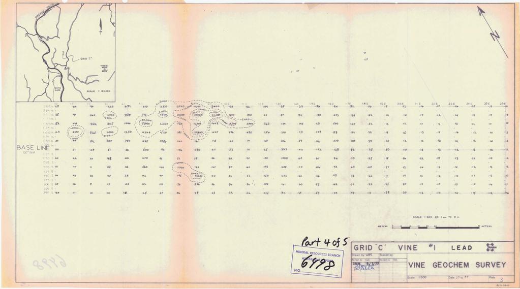
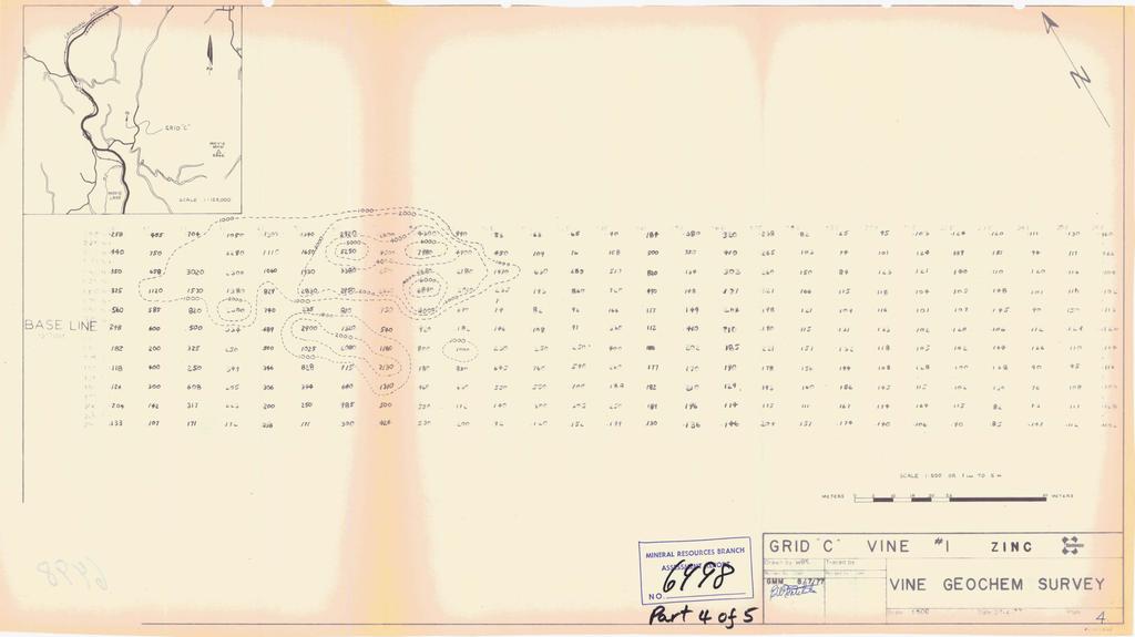
4 COMINCO LTD. I EXPLORATION DIVISION WE STERN DISTRICT 1.00 GENERAL STATEMENT This report describes a detailed soil geochemical survey on Vine 1 Claim (20 units), recorded on September 3, For assessment work reporting, Vine 1, Vine 25 (12 units) and Vine 27 (6 units) have been grouped. The survey was undertaken to explore for Cu/ Pb/Zn deposits in the Aldridge Formation. The survey was conducted intermittently between April 13th and June loth, A total of 297 samples were collected and analyzed by atomic absorption for ppm Cu, Pb and Zn. Total expenditures for soil geochemical program on Grid "C" were $2, An "Affidavit on Application to Record Work" which includes these expenditures was filed on September 1, 1977, with the Mining Recorder at Cranbrook, B. C INTRODUCTION 2.10 Status of Ownership All Vine claims are 100% Cominco owned Location and Access Vine 1 is located approximately 10 km SSW of Cranbrook, B.C., and access is via Highway 3/95 and good gravel road. Plate 1 is a location map showing Grid "C" relative to claim boundaries. N.T.S. 82G/5 M.D. Fort Steele Long : ' Lat : 49O25' Vine 1 claim covers an area of moderate relief ranging in elevation from 940 to 1390 m. Relief within the survey area is approximately 75 m. Vegetation varies from grassy open slopes to second growth lodgepole pine and Douglas fir GEOCHEMISTRY - Sampling Procedure A detailed soil geochemistry survey was conducted over an area of 50 m by 260 m. A baseline, with azimuth 120, was cut and flagged sample lines were established at 10 m intervals along the baseline. The sample interval along the lines was 5 m. Samples were collected from the "B" horizon of the soil profile using a grub hoe and were stored in wet strength haft bags Sample Preparation and Analysis Samples were dried at atmospheric temperature and were then sieved through a -80 mesh nylon screen. The samples were then shipped to Cominco s Exploration Research Lab in Vancouver for analysis.
5 Two grams of the -80 mesh fraction were digested in concentrated HC1 and HN03 by heating on a hot plate. The sample was then taken up in 10% HCl and bulked to 100 ml with distilled water. The samples were then analyzed by atomic absorption INTERPRETATION AND RESULTS Plates 2, 3 and 4 are contoured maps for Cu, Pb and Zn in ppm, from soils collected from Grid "C" on Vine 1 claim. Figures 1, 2 and 3 are graphs of percent cumulative frequency vs metal concentration plotted on log probability paper. The background and threshold values determined for each element are: Background (ppm) Threshold(ppm) East of line 14E, the Cu, Pb and Zn concentrations in soil samples decreases rapidly. This is thought to reflect increasing thickness of glacial till in that direction. Consequently, transported overburden may be obscuring any concentrations of Cu, Pb and Zn in bedrock STATEMENT OF EXPENDITURES The following summary of expenditures is taken from Form B, "Affidavit on Application to Record Assessment", for the St. Joe claim group, which was filed on September 1, Establishing Grid C: G. McDonald, Tech. - April 13, 14, 15, 18 $35/day.... $ D. MacDonald, Asst. - April 13, 14, 15, 18 4 $25.83/day Sampling Grid C: G. McDonald, Tech. - May 5, 6, 16, 18 4 $35/day D. McDonald, Asst. - May 5, 6, 16, 18 4days@ $25.83/day D. Byford, Asst. - June 3, 4, 6 3 $25.83/day B. Fisher, Asst. - June 3, 4, 6 3 $25.83/day Sieving Geochem Samples: D. Byford, Asst. - June 7, 8, 9 3 $25.83/day B. Fisher, Asst. - June 7, 8, 9 3 $25.83/day Map Preparation: G. McDonald, Tech.- June 7, 8, 9 3 $35/day Supervision: E.W. Batchelor, Geologist, June 9, 10, 13 3 $100/day continued --
6 EXPENDITURES - continued Analysis: 7. Domicile: 297 $2.50/sample.... $ man $10/day Transportation: 4 wheel drive rental, gas, repairs 8 $32/day TOTAL EXPENDITURES -- $2, SUBMITTED BY: ENDORSED BY: Assistant ~ &a~er,-~x~loration Western District September 15, 1977 APPROVED BY: Manager, ~x~loration Western District
7 EXHIBIT "A1' Statement of Expenditures Geochemical Survey - Vine Group - Grid C Establishing Grid C : G. McDonald, Tech. - April 13, 14, 15, 18 4days@$35/day.... $ D. MacDonald, Asst.- April 13, 14, 15, 18 4 $25.83/day Sampling Grid C: G. McDonald, Tech. - May 5, 6, 16, 18 4 $35/day... D. MacDonald, Asst.- May 5, 6, 16, 18 4 $25.83/day. D. Byford, Asst. - June 3, 4, 6 3 $25.83/day. B. Fisher, Asst. - June 3, 4, 6 3 $25.83/day. Sieving Geochem Samples: D. Byford, Asst. - June 7, 8, $25.83/day.... B. Fisher, Asst. - June 7, 8, 9 3 $25.83/day.... Map Preparation: G. McDonald, Tech. - June 7, 8, 9 3 $35/day Supervision: E.W. Batchelor, Geologist June 9, 10, 13 3 $100/day Ahlysis : 297 $2.50/sample Domicile: 18 man $10/day Transportation: 4 wheel drive rental, gas, reparis 8 $32/day TOTAL EXPENDITURES $ 2, SIGNED: This is Exhibit "A1' to the Statutory Declaration of E.W. Bat helor declared before me this 2' day of &?'JzM&/~, 1977.
8 IN THE MATTER OF THE B.C. MINERAL ACT AND IN THE MATTER OF A GEOCHEMICAL PROGRAMME CARRIED OUT ON THE VINE MINERAL CLAIMS (GRID C) in the Fort Steele Mining Division of the Province of British Columbia More Particularly N.T.S. 82G/5 AFFIDAVIT I, E.W. BATCHELOR, of the City of Cranbrook in the Province of British Columbia, make Oath and say: 1. That I am employed as a Geologist with Cominco Ltd. and as such, have a personal knowledge of the facts to which I hereinafter depose; 2. That annexed hereto and marked as Exhibit "A" to this my Affidavit is a true copy of expenditures incurred on a geochemical survey program, on the Vine Group of mineral claims. 3. That the said expenditures were incurred between the 13th day of April, 1977 and the 10th day of June, 1977, for the purposes of mineral exploration on the above claims. Sworn Before Me at &ad&- 1 in the Province of British Columbia, this ) davof,1977.) sfi&~&&x E.W! BATCHELOR
9 COMINCO LTD. EXPLORATION DIVISION WESTERN DISTRICT STATEMENT OF QUALIFICATIONS E.W. BATCHELOR graduated from U.B.C. during 1966 with a B.A.Sc degree in Geological Engineering. Since that time he has been employed in various phases of base metal exploration. D.W. HEDDLE. P. Eng. Assistant ~ &a~er, Exploration Western District -

10 Drawn by: ITraced by: I FIGURE 1 Rev~sed by Dale I Revised by Date Cu - Cumulative Frequency Distribution I I VINE PROPERTY - Grid "C" 82G/ 5 D I I Scale: Date: Plate: I Sept. 14,

11 I I Drawn by: Rev~sed by I Date Traced by: Rev~sed by Date FIGURE 2 Pb - Cumulative Frequency Distribution VINE PROPERTY - GRID "C" 82G/ ---, 5 - I Plate: 3, I I I I 1 Scale: Date: 1 Sept. 14, 1977 NCI - 112A-CL

12 Drawn by:,,. -J Revised by,_ i i. -' Traced by: Dale Revised by Dale. F: N FIGURE 3 Zn - Cumulative Frequency Distribution VINE PROPERTY - GRID "C" 82G/5 Scale: IDate: Sept. 14, 1977 /Plate: NCI- 112A-CL

13 9: 6; D.., ',. P'. &$':

14
15
16
COMINCO LTD. GRID A VINE CLAIM GROUP. Fort Steele Mining Division 82G/5. Sulilnit t ed by :
 COMNCO LTD. EXPLORATON DVSON WESTERN DSTRCT REPORT ON GEOCHEMCAL SURVEY GRD A VNE CLAM GROUP Fort Steele Mining Division 82G/5 Sulilnit t ed by : E.W. BATCHELOR Cominco Ltd. Kootenay Exploration 2450 Cranbrook
- LONGITUDE : 128'06 'W
 COMINCO LTD. WESTERN DISTRICT MARCH 1977 SOIL GEOCHEMICAL SURVEY SAND 1 and SAND 2 CLAIMS HIDDEN VALLEY AREA LIARD MINING DIVISION LATITUDE : 59'03' - LONGITUDE : 128'06 'W JUNE 20/76-JULY 12/76 REPORT
Work performed between August 1 and December 1, 1975 COMINCO LTD. WESTERN DISTRICT NTS 93 '(~15 EXPLORATION GEOCHEMICAL SURVEY THE CRY AND CAB CLAIMS
 COMINCO LTD. EXPLORATION WESTERN DISTRICT NTS 93 '(~15 GEOCHEMICAL SURVEY ON THE CRY AND CAB CLAIMS CRIN PROPERTY Work performed between August 1 and December 1, 1975 NICHOLAS L. SZABO TABLE OF CONTENTS
51 46'N Latitude, 119'44'1;!
 COMI)!CO LTD. EXPLORATION NTS: 82 1'1/13E GEOCHEKICAL ASSESSMENT REPORT ON THE SI 1 MINERAL CLAIM in the Kamloops Mining Division 51 46'N Latitude, 119'44'1;! Longitude Work Period: June 25, 1979 - July
COMINCO LTD. HORIZONTAL LOOP EM AND MAGNETIC SURVEYS ON SHA. CLAIMS 1, 2, 7 and 8 NELSON AND FORT STEELE MINING DIVISIONS, B.C.
 COMINCO LTD. EXPLORATION WESTERN DISTRICT NTS: 82-F/1 HORIZONTAL LOOP EM AND MAGNETIC SURVEYS ON SHA CLAIMS 1, 2, 7 and 8 - ASSESSMENT REPORT - NELSON AND FORT STEELE MINING DIVISIONS, B.C. Latitude Longitude
REPORT ON A GEOLOGICAL MAPPING AND PROSPECTING PROGRAM LOOK PROPERTY
 b KOKANEE EXPLORATIONS LTDI I WNO. 0 I- n c/ REPORT ON A GEOLOGICAL MAPPING AND PROSPECTING PROGRAM LOOK PROPERTY LOOK 1-31, 36-43 CLAIMS FORT STEELE MINING DIVISION CRANBROOK AREA N.T.S. 82G/5W + 4E E:
DIAMOND DRILLING REPORT VINE NO. 29 CLAIM. Fort Steele Mining Division OCTOBER Report by : G.L. WEBBER Geologist
 EXPLORATON DVSON DAMOND DRLLNG REPORT VNE NO. 29 CLAM Fort Steele Mining Division OCTOBER 1978 Latitude: 115O 53' Longitude: 490 21' Report by : G.L. WEBBER Geologist Kootenay Exploration 2450 Cranbrook
ASSESShAENT REPORT Mines and Petroleum Resources. Department of. No* JIMMY MINERAL CLAIM FRANKLIN CREEK AREA, GREENWOOD M. D.
 GEOCHEMICAL REPORT ON JIMMY MINERAL CLAIM FRANKLIN CREEK AREA, GREENWOOD M. D. Lat. 49'35' OON, N.T.S. Long. 118O22' 00W 82-E-9 July 18-21, 1974 Vancouver, B.C. J.J. McDougall, P.Eng. July 21, 1974 * Department
PHYSICAL WORK REPORT. the BAY CLAIMS. Omineca Mining Division Smithers, British Columbia N.T.S. 93E 13E/W
 PHYSICAL WORK REPORT the BAY CLAIMS Omineca Mining Division Smithers, British Columbia a N.T.S. 93E 13E/W LATITUDE: 53 57 00 N I LONGITUDE: 127 45 OO W for Home Ventures Ltd. 1201-675 West Hastings Street
1 i I.; :<7 6EOLOGICAL BRANCH ASSESSMENT REPORT HLEM, VLF-EM AND MAGNETOMETER TEST SURVEY ON THE ARC PROPERTY FOR SURVEY BY SJ GEOPHYSICS LTD.
 f - ~ --- j LOG NO: MAR 2 a 1992,,, -- - - - -- L$TiC'P;: I.; 1 i HLEM, VLF-EM AND MAGNETOMETER TEST SURVEY ON THE ARC PROPERTY FOR SURVEY BY SJ GEOPHYSICS LTD. SLOCAN M.D., B.C. N.T.S. 88 F/10 d 2- :
The SL group is located 10 miles east of Lac La Hache and can be reached by good secondary roads.
 0 Summary Soil samples were collected and analyzed for trace mercury vapour content over a magnetic and electromagnetic anomaly. Weak positive evidence of base metal mineralization was obtained. Location
of Youbou, V.I. on Work Done between Aulqust 10 and November four miles north 4a0w0 NE J.H. Mcmtqomery, Ph.D. P. Enq. GEOCHEMICAL SEPORT
 GEOCHEMCAL SEPORT on Work Done between Aulqust 10 and November 19. 1969, on Anne 23-3Ze 35-40 0.--...-, Mineral,..-... ~. -. -...: ::,;./.,....... ;; ' ',Claims.. owned::by Hlbernla Mlnlnq Co. Ltd.,' '..'
UNION MINIERE EXPLORATIONS AND MINING CORPORATION LIMITED ASSESSMENT REPORT ON FITINAT MINERAL CLAIM. Alberni Mining Division Record No.
 M F )( UNION MINIERE EXPLORATIONS AND MINING CORPORATION LIMITED Suite 200, 4299 Canada Way, Burnaby, B.C. V5G 1 H4 Telephone (604) 437-9491 ASSESSMENT REPORT ON GEOCHEMICAL SOIL SURVEYS AND ROCKSAMPLING
BALFOUR MINING LTD. (N.P.L.) HAM GROUP 92-P-6, CLINTON M. D.8 B. C. Lat 51 17'N, GEOCHEMICAL REPORT. V. CUKOR, P. Eng.
 HAM GROUP 92-P-6, CLINTON M. D.8 B. C. Lat 51 17'N, GEOCHEMICAL REPORT. V. CUKOR, P. Eng.") 34q '7 BALFOUR MINING LTD. (N.P.L.) HAM GROUP 92-P-6, CLINTON M. D.8 B. C. Lat 51 17'N, Long 12lo14'W GEOCHEMICAL REPORT, V. CUKOR, P. Eng. January 31, 1972 TABLE OF CONTENTS 1. INTRODUCTION 2. PROPERTY,
34q '7 BALFOUR MINING LTD. (N.P.L.) HAM GROUP 92-P-6, CLINTON M. D.8 B. C. Lat 51 17'N, Long 12lo14'W GEOCHEMICAL REPORT, V. CUKOR, P. Eng. January 31, 1972 TABLE OF CONTENTS 1. INTRODUCTION 2. PROPERTY,
GEOCHEMICAL STREAM SAMPLING. on the PLACER LEASES NO. Jordan River/Bear Creek Area. Victoria Mining Division. Latitude 48 degrees 32 minutes N.T.S.
 GEOCHEMCAL STREAM SAMPLNG on the PLACER LEASES NO P. 8149, 8150, 8151, 8152, 8161, 8162, 8163, 8400, 10844, 10845 Jordan River/Bear Creek Area Victoria Mining Division Latitude 48 degrees 32 minutes Longitude
R.A. COMINCO LTD. EXPLORATION NTS: 92H/16. WESTERN DISTRICT January 6, 1982 ASSESSMENT REPORT 1981 SOIL GEOCHEMISTRY ON THE TROUT PROPERTY
 COMINCO LTD. EXPLORATION NTS: 92H/16 WESTERN DISTRICT January 6, 1982 ASSESSMENT REPORT 1981 SOIL GEOCHEMISTRY ON THE TROUT PROPERTY (Trout 1 and 6 Claims) SIWASH LAKE AREA, SIMILKAMEEN M.D., B.C. (Work
49" 3-4 I4 I \ Y 59 tj
 ASSESSMENT REPORT Mary 4 FORT STEELE M.D. NTS 82G/5W 49" 3-4 4 \ Y 59 tj Owner: St. Eugene Mining Corporation Limited Operator : St. Eugene Mining Corporation Limited Author: John R. Wilson Date Submitted:
COMINCO LTD. GEOPHYSICAL REPORT ON AN INDUCED POLARIZATION SURVEY RIM PROPERTY RAFT RIVER AREA KAMLOOPS MINING DIVISION,
 COMNCO LTD. EX PLORAT ON WESTERN DSTRCT NTS: 82M/13E 25 JUNE 1981 GEOPHYSCAL REPORT ON AN NDUCED POLARZATON SURVEY RM PROPERTY RAFT RVER AREA KAMLOOPS MNNG DVSON, B.C. LATTUDE: 51'52'N LONGTUDE : 11 9'45
NTS 93L/9W GEOCHEMICAL AND GEOPHYSICAL REPORT MONA CLAIM OMINICA MINING DIVISION. Lati tude 54036'N; Longitude 'W
 GEOCHEMICAL AND GEOPHYSICAL REPORT ON MONA CLAIM OMINICA MINING DIVISION Lati tude 54036'N; Longitude 126018'W NTS 93L/9W April 1981 Paul Plicka Consulting Geologist LOCATION MAP INTRODUCTION TABLE OF
ASSESSMENT REPORT I.P./RESISTIVITY AND MAGNETICS SURVEY ON THE HAUTETE PROPERTY LATITUDE: 55O 12' N LONGITUDE: 126O 07' W
 NTS: 93W1 ASSESSMENT REPORT I.P./RESISTIVITY AND MAGNETICS SURVEY ON THE HAUTETE PROPERTY LATITUDE: 55O 12' N LONGITUDE: 126O 07' W OMINECA MINING DISTRICI'. B.C. CLAIMS COVERED : TET 1-8 TIME PERIOD:
COMINCO LTD. REPORT OF GEOCHEMICAL SURVEY ON THE CEDAR EXTN. GROUP FORT STEELE MINING DIVISION. Report by. D.L. Pighin. Exploration Technician
 COMINCO LTD. EXPLORATION DIVISION WESTERN DISTRICT t REPORT OF GEOCHEMICAL SURVEY ON THE CEDAR EXTN. GROUP FORT STEELE MINING DIVISION I LAT. 49' 44' - LONG. 1 I 5O 29' N.T.S. 82G/11 & 82G/12 I Report
3 I1 I I Ill 111 II! II 111 II Ill I IlE I I P I
 -7 3 1 1 11111111111111111111111111111111 ll 111! 111 111 111 111 111111111111111 ll 1111111 1 11111111111111 le P GEOCHEMCAL SURVEY OF THE KE AND D'ARCY CLAM GROUPS.. Similkameen Mining Division, B.C.
REPORT SOIL GEOCHEMICAL SURVEY. ATTYCELLEY NO. 2 GROUP (Attycelley Mineral Claims No. 7-10)
") REPORT SOIL GEOCHEMICAL SURVEY ATTYCELLEY NO. 2 GROUP (Attycelley Mineral Claims No. 7-10) Situated 7 miles east of north end of Thutade Lake, Omineca Mining Division British Columbia I Department of I
REPORT SOIL GEOCHEMICAL SURVEY ATTYCELLEY NO. 2 GROUP (Attycelley Mineral Claims No. 7-10) Situated 7 miles east of north end of Thutade Lake, Omineca Mining Division British Columbia I Department of I
GEOLOGICAL BRANCH ASSESSMTNF REPORT
 A GEOCHEMICAL REPORT on the 49 CR. GROUP APPROX. 9 mi SW OF NELSON, B.C 49 CREEK AREA NELSON NINING DIVISION BRITISH COLUNBIA NINERAL CLAIM MAP N. T.S. 82-~/6 WEST LATITUDE$ 49' 27'~ LONGITUDE : 117' 2j0w
RECONNAISSANCE GEOCHEMICAL SURVEY
 RECONNAISSANCE GEOCHEMICAL SURVEY LEGAL, RITA, LOUISE FR. (CHAPLEAU GROUP) REVERTED CROWN GRANTS CHAPLEAU CREEK AREAJ, SLOC& MINING DIVISION 82 F/11W Lat: 49'44" Long: 117"22'W MINERAL RESOURCES BRANCH
PRECIOUS METALS. owner. JMT Services Corp. GEOCHPlICAL SAMPLING CHELASLIE WCE, NORTH CENTRAL, B.C. OMINECA MINING DIVISION NTS 93F/5E & 6W
 PRECIOUS METALS REPORT ON 1980 RECONNAISSANCE GEOCHPlICAL SAMPLING CHELASLIE WCE, NORTH CENTRAL, B.C. OMINECA MINING DIVISION NTS 93F/5E & 6W LATITUDE 53O28 N LONGITUDE 125O31 W DATES Qp WORK: JULY 10
COMINCO LTD. DIAMOND DRILLING REPORT GRAVE LAKE GROUP NO. 1 82G/ 1 5W. Fort Steele Mining Division. Report by: G. L. Webber
 COMNCO LTD. EXPLORATON DVSON WESTERN DSTRCT DAMOND DRLLNG REPORT on GRAVE LAKE GROUP NO. 1 82G/ 1 5W Fort Steele Mining Division 5 6 Report by: G. L. Webber Cominco Ltd. Kootenay Exploration 2450 Cranbrook
REPORT ON MAGNETOMETER SURVEY TIK-1 CLAIM e&f KAMLOOPS MINING DTVISION. by D. Hendry D. C. MILLER. February 3, for
 REPORT ON MAGNETOMETER SURVEY TIK-1 CLAIM 92-1-14 e&f KAMLOOPS MINING DTVISION lat. 50 57 ' 12" long. 121O23 ' 37" OWNER: ST. JOSEPH EXPLORATIONS LIMITED OPERATIOR: ST. JOSEPH EXPLORATIONS LIMITED by D.
GRANGES EXPLORATION AB CANADIAN DIVISION
 GRANGES EXPLORATON AB CANADAN DVSON GEOCHEMCAL REPORT ON "B" and "D" CLAMS OMNECA MNNG DEVSON FAWNE NOSE AREA LATTUDE: 53O 19' LONGTUDE: 125O 1' MNERAL RESOURCES BRANCH N.T.S 93F/6 E Owner and Operator
GEOLOGICAL BRANCH ASSESSMENT REPORT 12. FItE NO: ACTION: THE GOLDEN MINING DIVISION, GOLDEN, Including THE NTS MAP; M82K/15W
 ACTION: FItE NO: Including 1990 GEO-CHEM SURVEY RESULTS -- THE AVD CLAIMS - THE GOLDEN MINING DIVISION, GOLDEN, B.C. NTS MAP; M82K/15W Lat. 50 deg. 55 Min. Long 116 deg. 55 min. For GEOLOGICAL BRANCH ASSESSMENT
SOIL GEOCHEMISTRY. OK-ll AND OK-Ill MINERAL CLAIMS MOUNT THOEN AREA OMINECA MINING DIVISION, B.C. NTS 93 MI6 E & 7 W
 SOIL GEOCHEMISTRY OK-ll AND OK-Ill MINERAL CLAIMS MOUNT THOEN AREA OMINECA MINING DIVISION, B.C. NTS 93 MI6 E & 7 W LATITUDE 55O23'N, LONGITUDE 127 01W Locke B. Goldsmith, P.Eng. Consulting Geologist December
SOIL GEOCHEMISTRY ENTERPRISE MINE NTS 82 F/14 W ARCTEX ENGINEERING SERVICES CONSULTANT, OWNER, OPERATOR, AUTHOR JANUARY, 1.981
 SOIL GEOCHEMISTRY ENTERPRISE MINE t SLOCAN MINING DIVISION, Bn C, NTS 82 F/14 W LATITUDE 49'49') LONGITUDE 1'19' ARCTEX ENGINEERING SERVICES I L, B, GOLDSMITH, PiENG, CONSULTANT, OWNER, OPERATOR, AUTHOR
MtNERAL EXPLORATION CONSULTANTS ASSESSMENT REPORT MT. MILLIGAN AREA OMINECA M.D. Latitude: 55' 07' N Longitude: 123" 56' W NTS : 93 0/4 W.
 D. L. COOKE AND ASSOCIATES LTD. MtNERAL EXPLORATION CONSULTANTS ASSESSMENT REPORT 1989 PRELIMINARY GEOCHEMICAL SURVEY KC MINERAL CLAIMS MT. MILLIGAN AREA OMINECA M.D. Latitude: 55' 07' N Longitude: 123"
ASSESSMENT REPORT ON THE VLF-EM SURVEY. Trail Creek Mining Division NTS: 82 F/4 W Longitude: 1 17' 49' 50" Latitude: 49O 03' 40"
 ASSESSMENT REPORT ON THE JERO 5 MINERAL CLAIM ROSSLAND, BRJTISH COLUMBIA VLF-EM SURVEY Trail Creek Mining Division NTS: 82 F/4 W Longitude: 1 17' 49' 50" Latitude: 49O 03' 40" Owner: Operator: Author:
510 W. HASTINGS STREET
 GEOCHEMICAL SOIL SURVEY OF THE DILLARD & MABEL AREAS BRITISH COLUMBIA PREPARED FOR : CYPRUS EXPLORATION CORPORATION LIMITED 510 W. HASTINGS STREET VANCOUVER,B.C. PREPARED BY: BARRINGER RESEARCH LIMITED
GEOCHEMICAL REPORT THE 82M/12 FH GROUP BIRCH ISLAND, B.C. S1 119O NOW. ROYAL CANADIAN VENTUR 3S LTD. By: Vollo, P. Eng. N.B. Pay 28th, 1969.
 c GEOCHEMICAL REPORT ON THE 82M/12 FH GROUP AT BIRCH ISLAND, BC S1 119O NOW BY ROYAL CANADIAN VENTUR 3S LTD NB By: Vollo, P Eng Pay 28th, 1969 Approximately 700 samples were collected over 14 miles of
ASSESSMENT REPORT MAGNETOMETER SURVEY GOLDEN ROD, GOLDEN ROD #2. Long.: General Delivery, Vananda, B. C.
 ASSESSMENT REPORT MAGNETOMETER SURVEY GOLDEN ROD, GOLDEN ROD #2 t=/ NTS 92~110w Lat.: Long.: 49O 44' N 124O 34' W Owner: E. Johanson General Delivery, Vananda, B. C. Operator: Rhyolite Resources I nc.
Geo chemi c a1 Rep or t SILVER KING FAST GROUP. H. S. Lazenby Geologist. Vancouver, B.C. 16 November 1967
 Geo chemi c a1 Rep or t on SILVER KING FAST GROUP 1967 Vancouver, B.C. 16 November 1967 H. S. Lazenby Geologist Contents Introduction P. 1 Method of Survey P. 1 Interpretation of Results p. L&2 Statement
UMEX UNION MlNlERE EXPLORATIONS. AND MINING CORPORATION LIMITED
 UMEX UNION MlNlERE EXPLORATIONS. AND MINING CORPORATION LIMITED SUITE 200 I 4299 CANADA WAY BURNABY. RC. vso in4 TELEPHONE 437-949 i GEOCHEMICAL SOIL SURVEY CLAW -20 MINEFULL CLAIlW (Record Numbers 70095-7002,
GEOPHYSICAL REPORT CHU CHUA PROJECT Green Mountain Group. KAMLOOPS MINING DIVISION NTS 92P/8E, 82M/5W Lat: 51'24' N Long: 120'00' w
 I GEOPHYSICAL REPORT CHU CHUA PROJECT Green Mountain Group KAMLOOPS MINING DIVISION NTS 92P/8E, 82M/5W Lat: 51'24' N Long: 120'00' w I rvm #.,_..._..._._._.- $...-...! 1 VANCOUVER, B.C. 1 G E 0 I, 0.G
M.R.# _..._ $._. ' VANCOUVER, R.C
 COMINCO LTD. EXPLORATION NTS: 0G/ WESTERN CANADA 0 November ASSESSEMENT REPORT GEOCHEMICAL SURVEY ON THE SADDLEHORN PROPERTY LIARD MINING DIVISION BRITISH COLUMBIA M.R.# _....._ $._. ' VANCOUVER, R.C I
7 miles West of Kamloops, B.C.
 MINERAL RESOURCES BRANCH ASSEWAENT RiPORT of hole # 78-11 NO. drilled on the ZZ # 18 Claim of China Commercial Corporation Ltd situated 7 miles West of Kamloops, B.C. in the Kamloops Mining Division D.R.
6. E. Spencer Engineering Ltd. '1 iias k*-&-!
 6. E. Spencer Engineering Ltd. '1 iias k*-&-! CONSULTING GEOLOGICAL ENGINEER REPORT ON A GEOCHEMICAL SOIL SURVEY ON THE AXL 3 MINERAL CLAIM KAMLOOPS MINING DIVISION, N.T.S. 82,M/4 LATITUDE: 51O N, LONGITUDE:
GEOLOGICAL MAPPING REPORT ON THE ASH MINERAL CLAIM OSOYOOS MINING DIVISION ASHNOLA RIVER MAP SHEET NTS M092,H019 MCBRIDE CREEK AREA, ASHNOLA RIVER,
 GEOLOGICAL MAPPING REPORT ON THE ASH MINERAL CLAIM OSOYOOS MINING DIVISION ASHNOLA RIVER MAP SHEET NTS M092,H019 LATITUDE 49 o O6, LONGITUDE 120 o 22 MCBRIDE CREEK AREA, ASHNOLA RIVER, KEREMEOS, B.C. CANADA
BRENDA MINES LTD. EXPLORATION GROUP. REPORT on. GRID LINES and GEOCHEMICAL SOIL SURVEY. on the TROUT CREEK PROPERTY. Similkameen Mining District
 BRENDA MINES LTD. EXPLORATION GROUP REPORT on GRID LINES and GEOCHEMICAL SOIL SURVEY on the TROUT CREEK PROPERTY Similkameen Mining District Lat. 49' 47', Long. 120 09' N.T.S. 92B/16 A.R. Pollmer Chief
FILE NO. ASSESSMENT REPORT VLF-EM GEOPHY S I CS BUCK CLAIMS. Moyie River and Perry Creek Area FORT STEELE MINING DIVISION. NTS 82 F/8 E and 82 G/5 W
 FILE NO. ASSESSMENT REPORT on - VLF-EM GEOPHY S I CS BUCK CLAIMS Moyie River and Perry Creek Area FORT STEELE MINING DIVISION NTS 82 F/8 E and 82 G/5 W Latitude 49 27' N Longitude 116 03' W PETER KLEWCHUK
GEOLOGICAL BRAN ASSESS
 TITLE PAGE This report covers assessment work performed on the Mundy group, located in the Boundary Creek area, north of Greenwood, British Columbia. The work comprises of THM soil testing, trenching and
Prospecting Report 'S Office i DB Property, B.C. -J Negro Creek Nelson Mining District NTS 82F.050. Operator: Kootenay Gold Inc.
 . '.' I"' i9 12 Prospecting Report 'S Office i DB Property, B.C. -J Negro Creek Nelson Mining District NTS 82F.050 Operator: Kootenay Gold Inc. Owner: Darlene Lavoie Work Performed Summer of 2007 Report
Assessment Work Report. on the Geophysical Surveys carried out over the
 Assessment Work Report on the Geophysical Surveys carried out over the PINE GROUP of Mineral Claims 951-J-15-W Lillooet Mining Division Goldbridge, B.C. Long 122 48' Lat. 50 48' by Levon Resources Ltd.
for the Greenwood Mining Division, B.C. NTS 82E/7W Latitude 49' 27' W, Longitude 118' 5 Prepared by a= D. Dylan Watt, B.Sc.
 t. b LOGnO: 37~ -08 m. ACTIO#: for the AMP AMP 2 AMP 3 t AMP 4 CLAIMS Greenwood Mining Division, B.C. NTS 82E/7W Latitude 49' 27' W, Longitude 8' 5 %E c,w zc *& a w Prepared by a= -4c. D. Dylan Watt, B.Sc.
ASSESSMENT REPORT ON THE PEAVINE PROJECT. DGW & Associates # Alberni Street, Vancouver, British Columbia, V6E 4V2
 ASSESSMENT REPORT ON THE PEAVINE PROJECT KAMLOOPS MINING DIVISION BRITISH COLUMBIA NTS 082M 12 Latitude 51 36' 19.0"North -- Longitude --119 47' 27.0"West UTM Zone 11, NAD 83 5720827N 306744E Prepared
Serengeti Resources Inc GEOCHEMICAL REPORT ON THE SHADOW PROPERTY a.
 Serengeti Resources Inc. 2004 GEOCHEMICAL REPORT ON THE SHADOW PROPERTY a. Located in the Johanson Lake Area Omenica Mining Division NTS 94D/9 6 degrees and 32 minutes North Latitude 126 degrees and 2
..!I AXE CLAIMS ON THE. for RICHCORE EXPLORATIONS LTO. GREENWOOD MINING DIVISION BRITISH COLUMBIA. Latitude 49O 30"; Longitude 118' 30'W NTS 82E/9W
 ON THE AXE CLAIMS for RICHCORE EXPLORATIONS LTO. GREENWOOD MINING DIVISION BRITISH COLUMBIA Latitude 49O 30"; Longitude 118' 30'W NTS 82E/9W... -... ~ i.,...._.'..!i Vancouver, B.C. September, 1980 P.
0.. HUDSON BAY EXPLORATION AND DEVELOPMENT COMPANY LIMITED OMINECA MINING DIVISION BRITISH COLUMBIA REPORT ON EXPLORATION PROGRAM
 'I '0; 63 HUDSON BAY EXPLORATION AND DEVELOPMENT COMPANY LIMITED LSD CLAIM PROPERTY OMINECA MINING DIVISION Q. i!' p BRITISH COLUMBIA REPORT ON EXPLORATION PROGRAM - 972 BY R. A. FREBERG, P. ENG. SEPTEMBER
DEVELOPMENT REPORT. Lone I Mineral Claim Group. Wild Horse River Area Cranbrook, B.C.
 DEVELOPMENT REPORT Lone I Mineral Claim Group Wild Horse River Area Cranbrook, B.C. Fort Steele Mining District NTS 82G/12E 49 38 35 Latitude 115 38 00 Longitude LONE PEAK PLACER LTD. 514-13th Avenue South
SUMMl'l WlLS LIU. GEOPHYSICAL REPORT. W. CT. a~evenson Y I
 SUMMl'l WlLS LIU. GEOPHYSICAL REPORT W. CT. a~evenson Y3 qi@, 1970. I 2-90 9 CONTENTS - PAGE Introduction... 1 Property... 1 Location and Access... 1 Survey Specifications Survey Grid... 1 Induced Polarization
GEOPHYSICAL REPORT THE CAVZ CLAIMS
 GEOPHYSICAL REPORT Magnetometer Survey on THE CAVZ CLAIMS CAVZ M.C.'s 1 to 12, 15 to 26, 29 to 40, 45 to 54 Trail Peak, Omineca M.D. 13 miles northeast of Fort Babine 550 ) 126 S.E. by G.Podolsky J.Russell
! I TULAMEEN AREA PROPERTY. Report on a Geological prospecting and Geochemical W-Survey. Northing m Easting m. Latitude 49' 34' 05" N
 ! I Report on a Geological prospecting and Geochemical W-Survey TULAMEEN AREA PROPERTY I I N.T.S. MO9W 1OW I ' OWNER Northing 5494000m Easting 658000 m Longitude 120O48' 48" W Latitude 49' 34' 05" N Henley
RE~ORT ON. J.F.V. MILLAR, P. Eng. GEOCHEMICAL SURVEY TIMBASKET AND MOGUL MINERAL CLAIMS. Kinbasket Lake, B. C. 51 degrees 118 degrees N.E.
 RE~ORT ON GEOCHEMICAL SURVEY TIMBASKET AND MOGUL MINERAL CLAIMS Kinbasket Lake, B. C. 51 degrees 118 degrees N.E. J.F.V. MILLAR, P. Eng. Lease held by J.F.V. MILLAR Work done Sept. 22 - Oct. 3, 1967. REPORT
COMINCO LTD. GEOPHYSICAL REPORT FOR THE UTEM ELECTROMAGNETIC SURVEY ON THE CLAIR 4 CLAIM FORT STEELE MINING DIVISION, B.C. 4g037'N : 116O15'W
 EXPLORATION NTS.: 82F/9 I COMINCO LTD. WESTERN DISTRICT 1 I P '1 I GEOPHYSICAL REPORT FOR THE UTEM ELECTROMAGNETIC SURVEY ON THE CLAIR 4 CLAIM FORT STEELE MINING DIVISION, B.C. Latitude Longitude 4g037'N
1 CLAIMS GEOPHYSICAL REPORT ON BOYAL SITUATE NORTHEAST OF TILLICUM MOUNTAIN GOLD AREA BURTON - NAKUSP SIQCAEJ MINING DIVISION
 GEOPHYSICAL REPORT ON BOYAL 1 CLAIMS SITUATE NORTHEAST OF TILLICUM MOUNTAIN GOLD AREA BURTON - NAKUSP SIQCAEJ MINING DIVISION CONSULTING GEOLOGIST AUGUST 1983 VANCOUVER B *C INDEX INTRODUCTION ooa,.eoaaa.aaaoaaooaoa~ao~o
GEOCSZNICAL - SURVEY. ICAMLOOPS Kl.D. 2'' 6;kr. HY "'f. Alfred R. Allen,P.Eng. 1 NO.%=...,... 6"- 'I.
 t i.i GEOCSZNICAL - SURVEY i p' ICAMLOOPS Kl.D. 2'' 6;kr HY 50-64 +."'f 121-51 NE 5-10-70 : 19-10-70 Alfred R. Allen,P.Eng. I) ' 1 6"- 'I. 1 NO.%=...,..... Q.C. EXPLORATIONS LTD. 2Cl- 535 Kowe Street Vancouver
m7m NO..._.. _... SELCO MINING CORPORATION LIMITED REPORT ON GEOCHEMICAL RECONNAISSANCE SOKEREIGN CREEK ... MAP
 u u 428.7 u U SELCO MNNG CORPORATON LMTED REPORT ON GEOCHEMCAL RECONNASSANCE AT m7m SOKEREGN CREEK u 0 0 u u u Ng7 NO...._.. _.............. MAP...-......- GEOLOGCAL RECONNASSANCE AT SOVEREGN CREEK, B.C.
cpw 6. E. Spencer Engineering Ltd. HANNA 9 M. C. 104 REP 0 RT DIAMOND DRILLING PROGRAMME LIARD MINING DISTRICT, K.T.S. FOR TAURUS RESOURCES LTD.
 6. E. Spencer Engineering Ltd. LlJ REP 0 RT ON DAMOND DRLLNG PROGRAMME cpw HANNA 9 M. C. LARD MNNG DSTRCT, K.T.S. 104 P@g FOR TAURUS RESOURCES LTD. BY B. E. SPENCER, P. ENG. B. E. SPENCER ENGNEERNG LTD.
GEOCMCAL SURVEY LOOP PROPERTY NCRAIIDA EXPLORATION COMPANY, LIMITED OMINECA MINING DIVISION JULY 5, 1971 TO JULY 30, 1971
 GEOCMCAL SURVEY LOOP PROPERTY NCRAIIDA EXPLORATION COMPANY, LIMITED OMINECA MINING DIVISION JULY 5, 1971 TO JULY 30, 1971 TABLE OF CONTENTS INTRODUCTION 2 li Fig. A (Incation Map) GENERAL GEOLOGY GRID
GEOCHEMICAL REPORT LAST LINK GROUP TEXADA ISLAND NANAIMO MINING DIVISION
 I GEOCHEMICAL REPORT LAST LINK GROUP TEXADA ISLAND NANAIMO MINING DIVISION -1- PROSPECTING & GEOCHEMICAL SOIL SURVEY FOR GOLD On the Last Link Group of Claims North End of Texada Island Nanaimo Mining
ASSESSMENT' REPORT GEOPHYSICAL REPORT ON THE ATTORNEY 2 CLAIM (4 UNITS) OMINECA MINING DIVISION SHEILA A. CRAWFORD.
 OMINECA MINING DIVISION SHEILA A. CRAWFORD.") ASSESSMENT' REPORT GEOPHYSICAL REPORT ON THE ATTORNEY 2 CLAIM (4 UNITS) OMINECA MINING DIVISION by SHEILA A. CRAWFORD LOCATION: 57z17' N Latitude 127 11' W Longitude N.T.S. 94E/6E OWNER/OPERATOR: SEREM
ASSESSMENT' REPORT GEOPHYSICAL REPORT ON THE ATTORNEY 2 CLAIM (4 UNITS) OMINECA MINING DIVISION by SHEILA A. CRAWFORD LOCATION: 57z17' N Latitude 127 11' W Longitude N.T.S. 94E/6E OWNER/OPERATOR: SEREM
on the Diamond Drilling done on the LAKESIOE GROUP of Mineral Claims SLOCAN MINING DIVISION 82-F-14-W Long ' Lat '
 Assessment Work Report on the Diamond Drilling done on the LAKESIOE GROUP of Mineral Claims SLOCAN MINING DIVISION 82-F-14-W Long 117 22' Lat. 49 58' ADRIAN KESLER SILVERTON, B.C. operator LEVON RESOURCES
GEOCHEMICAL REPORT ON THE YEP CLAIMS, Clinton Mining Division. P.E. Fox, PhD. P.Eng.
 CLNTON 1 MNNG RECORDER GEOCHEMCAL REPORT ON THE YEP CLAMS, Clinton Mining Division P.E. Fox, PhD. P.Eng. Fox Geological Consultants Ltd 204-635 Victoria St. Kamloops, B. C. August 5, 1974 Work done: Juge
PERCY CONTRACTING SERVICES LTD.
 GEOLOGICAL REPORT ON TEN PLACER LEASES (3139, 3140, 3141, 3142, 3143, 3144, 3145, 3146, 3147, 3148) MOREHEAD CREEK CARIB00 MINING DIVISION, B.C. 938/12W (52 38 N, 121 47 W) For PERCY CONTRACTING SERVICES
Mines and,3efro!sgrn Resources
 on the JO ANN MINERAL C LAIMS 35 Miles Northwest of Germansen Landing, B.C. Omineca Mining Division British Columbia MineralClaimMap 93N/13E, 14W Latitude: 55O 57' Longitude: 125O 28' by Douglas Stelling,
SIXTH SCHEDULE REPUBLIC OF SOUTH SUDAN MINISTRY OF PETROLEUM, MINING THE MINING (MINERAL TITLE) REGULATIONS 2015
 REGULATIONS 2015") SIXTH SCHEDULE REPUBLIC OF SOUTH SUDAN MINISTRY OF PETROLEUM, MINING THE MINING ACT, 2012 THE MINING (MINERAL TITLE) REGULATIONS 2015 Guidelines should be prepared by the Directorate of Mineral Development
SIXTH SCHEDULE REPUBLIC OF SOUTH SUDAN MINISTRY OF PETROLEUM, MINING THE MINING ACT, 2012 THE MINING (MINERAL TITLE) REGULATIONS 2015 Guidelines should be prepared by the Directorate of Mineral Development
ASSESSMENT REPORT. Geochemical and Geological Surveys. on the. Gooch#1-4. Mineral Claims. Omenica Mining District NTS 93L/7W
 f- GEOLOGICAL BRANCH ASSESSMENT REPORT ASSESSMENT REPORT Geochemical and Geological Surveys on the Gooch#1-4 Mineral Claims Omenica Mining District NTS 93L/7W LAT: 54O25'W LONG: 126O26'W Operator: SMD
NICOLA M.D King Street West, April, 1969 AMALG 1-44 MINERAL CLAIMS 1. OWNER: Dr. F. R. Burton, W. M. Sirola, P. Eng.
 REPORT ON ' MAGNETIC AND ELECTROMAGNETIC SURVEY AMALG 1-44 MINERAL CLAIMS 1. NICOLA M.D. 49'501 N - 12Oo57f W OWNER: Dr. F. R. Burton, 1506-44 King Street West, Toronto 1, Ontario. by W. M. Sirola, P.
7 MILES WEST OF PORT HARDY, B.C.
 GEOPHYSICAL REPORT VERTICAL INTENSITY MAGNETOMEER SURVEY ON LUK CLAIMS, 7 MILES WEST OF PORT HARDY, B.C. 50' 127O SE BY R. E. SHIELDS UNDER SUPERVISION OF J. R. BILLINGSLEY FOR SECOND0 MINING LTD. (N.
sq N & %%.& GEOPHYSICAL CONSULTING rr SERVICES LTD. $%& Long. 118o3OtW N.T.S. 82 E/15 -I- AUTROR: Glen E. Whi*e, B.Sc., P. %g.
 -\ GEOCHEMICAL EXPORT.,~.,~..'.. AMORE MINERALS 1NCORPOR;ITZC,' ~. 3rd fl5 Geo 3. and 2 mineral claims, Vernon- ~ $lining Division, B. C. Lat. 49 47'T?,,/ Long. 118o3OtW N.T.S. 82 E/15 -I- AUTROR: Glen
58 l'gr'n 'E. Date: January 23, 1979 ASSESSMENT REPORT PLACER SAMPLING & JADE BOULDER EVALUATION PLACER LEASE Liard Mining Divison 1041/7E
 ASSESSMENT REPORT PLACER SAMPLING & JADE BOULDER EVALUATION PLACER LEASE 1711 Liard Mining Divison 1041/7E 58 l'gr'n 18 38'E Owner & operator: Cry Lake Jade Mines Ltd. Author: A.M. Homenuke, P.Eng. Date:
46s9. on the. July 19, 1973 to July 24, October, Troup 92-P-8. i nc I u s ive
 N.T.S.= 92-P-8 GEOCHEMICAL REPORT on the 'DUM' CLAIM GROUP A.G. Troup October, 1.473 -.- Names - Record Numbers DUM 1-24 inclusive 122804 to 122827 LOCATION: Little Fort area, British Columbia N.T.S. 92-P-8
LH Property Update: Magnum Goldcorp Hits High Grade Gold 16.9 m of g/t, including 10.9 m of g/t, and as well, 11 m of 20.
 Trading symbol: TSX-V: IBC News Release No. 15-04 2489 BELLEVUE AVENUE WEST VANCOUVER, BC V7V 1E1 TEL 604 922 2030 FAX 604 922 2037 TOLL FREE (CANADA) 1 888 888 9122 TOLL FREE (USA) 1 888 888 9123 LH Property
GEOLOGICAL SURVEY BRANCH ASSESSMENT REPORT
 GEOLOGICAL SURVEY BRANCH ASSESSMENT REPORTS DATE RECEIVED NOV 1 3 1996 ASSESSMENT REPORT -. on LINE CUTTING and DIAMOND DRILLING ABITIBI MINING CORPORATION BARR PROPERTY Palmer Bar Creek Area Fort Steele
PHYSICAL WORK REPORT ON THE. KINGDOMlwINERAL LILLOOET MINING DIVISION. NTS Map Sheet 92J/15W. Co-Ordinates North: East
 PHYSICAL WORK REPORT ON THE KINGDOMlwINERAL CLAIM LILLOOET MINING DIVISION NTS Map Sheet 92J/15W Co-Ordinates North: 50 48 East 120 48 For Assessment Work BY Edward Skoda October 15,2002 Vancouver, British
490 20' 30" North Latitude ' 30" West Longitude
 _._.. I CONSULTING GEOLOGISTS 605-602 WEST HASTINGS STREET, VANCOUVER, B.C. V6B 1P2 TELEPHONE: (604) 689-5533 6 I F: ASSESSMENT REPORT ON THE PATSY 1 MINERAL CLAIM ' '?%2% I WHISTLE CREEK, HEDLEY ARE L-l-
Geochemical Assessment Report. on the. Situated Nineteen Kilometres rth-northeast of Hope, B. C. in the. New Westminster Mining Division
 7 I Geochemical Assessment Report r on the r- I 1 Norm 1 to Norm 4 Mineral Claims c - I - 7 Situated Nineteen Kilometres rth-northeast of Hope, B. C. in the New Westminster Mining Division itude 49*32'N.,
NO. MAP..._._..._...,,..,.
 KERR- ADDISON GOLD MINES LIMITED SELF-POTENTIAL SURVEY OWL!i- 12 1 Dwner ) NAOINA 1-4 ) MINERAL CLAIMS W. F. McGowan, ) 3262 Marine Orive, ANGUS 1-4 ) west Vancouver, 8. c. LOCATED AT 5. E. ENO OF OWEN
3304 Cambie bt. Vancouver, B.C.
 KEPOKT OF GEOCHEMICAL 5UKVEY KING GKOUP LILLUOET MINING DIVISION for BENN EXPLORATIONS LTD. 3304 Cambie bt. Vancouver, B.C. by E. J. Schutz June 15 - August 10,1966 bupervised by + F. C. Tomlinson, P.EWT.
ASSESSMENT REPORT GRID LOCATION SOIL GEOCHEMICAL SURVEY CAT TRAIL CONSTRUCTION. at Mohawk Creek, B. c.
 ASSESSMENT REPORT GRID LOCATION SOIL GEOCHEMICAL SURVEY CAT TRAIL CONSTRUCTION at Mohawk Creek, B. c. _....,.. :lii I. 50"46'N, 118O36'W Claims: Mohawk 1, 8 Ff, 9 Fr, 10 Fr. Hawk 2, 3 Pool 3, 5 Fr Fiver
W. 1.NELSON Jr. P. ENG.
 GEOCHEMICAL AND GEOPHYSICAL SURVEY SNO GROUP CLAIMS W. 1.NELSON Jr. P. ENG. NORANDA EXPLORATION COMPANY, LIMITED OMINECA MINING DIVISION AUG. 17, 1971 - AUG. 29, 1971 TABLE OF CONTENTS - Page INTRODUCTION
Reconnaissance. Of the. Denis mineral claims. Situated at Kilometer 844 of the Alaska Highway. Liard Mining Division. Northeastern British Columbia
 Reconnaissance Of the Denis mineral claims Situated at Kilometer 844 of the Alaska Highway Liard Mining Division Northeastern British Columbia N.T.S. 94M.075 Latitude 59 42 25 Longitude 127 13 12 Field
TOPOGRAPHICAL SURVEY REPORT ON THE GREENDROP PROPERTY NEAR CHILLIWACK, B.C. 92-H-3/W
 TOPOGRAPHICAL SURVEY REPORT ON THE GREENDROP PROPERTY NEW WESTMINSTER M.D. NEAR CHILLIWACK, B.C. 92-H-3/W Location: The central pap of the claims is located at coordinates 49 08'N, latitude by 121 26'W,
DIAMOND DRILL REPORT ON THE LOCATED IN THE OMINECA MINING DIVISION FAWNIE NOSE AREA LATITUDE: 53O 17' LONGITUDE: 125O 10' NTS 93F 6E
 GRANGES EXPLORATION AB CANADIAN DIVISION DIAMOND DRILL REPORT ON THE G, H and I CLAIM BLOCKS LOCATED IN THE OMINECA MINING DIVISION FAWNIE NOSE AREA LATITUDE: 53O 17' LONGITUDE: 125O 10' NTS 93F 6E. -.
'-7' REPORT ON A MAGNETOMETER SURVEY OVER PART OF THE MAX CLAIM GROUP 1-20 LAC LE JEUNE AREA KAMLOOPS MINING DIVISION KAMLOOPS, BRITISH COLUMBIA
 I,., - SUITE 102. 222 BELLEVUE WES t ANCOUVER, B. '-7' REPORT ON A I MAGNETOMETER SURVEY OVER PART OF THE MAX CLAIM GROUP 1-20 LAC LE JEUNE AREA KAMLOOPS MINING DIVISION KAMLOOPS, BRITISH COLUMBIA 50-30
PHOENIX GEOPHYSICS LIMITED REPORT ON THE VLF-EM AND TOTAL FIELD MAGNETOMETER SURVEYS ON THE
 PHOENIX GEOPHYSICS LIMITED REPORT ON THE VLF-EM AND TOTAL FIELD MAGNETOMETER SURVEYS ON THE TAN CLAIMS, CHILLIWACK AREA NEW WESTMINSTER MINING DIVISION, BRITISH COLUMBIA FOR LORNEX MINING CORPORATION LIMITED
2013 GEOLOGICAL ASSESSMENT REPORT SHERIDAN HILL PROPERTY
 2013 GEOLOGICAL ASSESSMENT REPORT ON THE SHERIDAN HILL PROPERTY NEW WESTMINSTER MINING DIVISION BRITISH COLUMBIA NTS 092G07 49 16 31 NORTH LATITUDE, 122 39 48 WEST LONGITUDE PREPARED FOR Sheridan Hill
GRISWOLD CREEK, B.C. 6 " GEOCHJ3lICAL REPORT
 GRISWOLD CREEK, B.C. 6 " GEOCHJ3lICAL REPORT AUTROR: W. Meyer, BSc. ENDORSED El!: John De Leen, BASc.* NASc., E.M., P. Eng. No. 3675 Vancouver, B.C. January 22nd, 1965. -I- During the period of July 27th
Lat. 52' 43' N Long ' W
 &A exploration ltd MINING ENGINEERING GEOLOGY- GEOPHYSICS 4570 HOSKINS ROAD, NORTH VANCOUVER, 6. C. TELEPHONE (804) 985,7921 V7K 2R1 GEOLOGICAL AND GEOCHEMICAL REPORT on the BLUE CLAIMS Cariboo Mining
PROSPECTING REPORT. re. Minera.1 C laims
 PROSPECTING REPORT re. Minera.1 C laims P R 1 Record #3052 (6) P R 2 Record #3053 (6) p R 3 Record #3054 (6) at Ilong.129, Latt. 58 20' in the Two Mile Creek area of Turnagain River drainage system in
RECONNAISSANCE GEOPHYSICAL SURVEY HELICOPTER - BORNE V. L.F. ELECTROMAGNETIC AND MAGNETIC GALLOWAY AREA FORT STEELE M.D., B.C.
 RECONNAISSANCE GEOPHYSICAL SURVEY HELICOPTER - BORNE V. L.F. ELECTROMAGNETIC AND MAGNETIC GALLOWAY AREA FORT STEELE M.D., B.C. Balsam 1-4 & 5-12 Cedar 1 & 2 Cedar South 1 & 2 Elderberry 1 Elderberry South
Negro Creek Fort Steele Minina Division. CRAIG KENNEDY Prospector
 AUG and SKAY Claims Negro Creek Fort Steele Minina Division NTS 82 F8/E Latitude 49O28 N Lonqi tude 116 Ol W BY CRAIG KENNEDY Prospector September 5, 1996 TABLE OF CONTENTS Page 1.00 INTRODUCTION 1.10
GIANT MASCOT MINES LIMITED ~nen~z~s~11~uumsn~ SURRARD STREET VANCOUVER 1, B. C. June 4, 1968
 NtNI OFFICE; P. 0. BOX 820. HOPE. 8. C. TELEP*ON
Date Submitted: June General Nature of Report: Examination of Placer Samples
 General Nature of Report: Examination of Placer Samples Claim: Gold Channel, Record Number 3775!8 1 (Gold Channel Placer Property) Mining Division: Cariboo NTS 093 G 09 W and E Latitude 520 23 N' Longitude1210