ASSESSMENT REPORT GRID LOCATION SOIL GEOCHEMICAL SURVEY CAT TRAIL CONSTRUCTION. at Mohawk Creek, B. c.
|
|
|
- Ashley Beasley
- 5 years ago
- Views:
Transcription
1 ASSESSMENT REPORT GRID LOCATION SOIL GEOCHEMICAL SURVEY CAT TRAIL CONSTRUCTION at Mohawk Creek, B. c. _....,.. :lii I. 50"46'N, 118O36'W Claims: Mohawk 1, 8 Ff, 9 Fr, 10 Fr. Hawk 2, 3 Pool 3, 5 Fr Fiver 2, and Crown granted claims: Lot 4500, 4572, 4573, 4763, 5170, 5675, 5677, 9137, Revelstoke Mining Division N.T.S.: 82K/13 November 12, 1982
2 TABLE OF CONTENTS PAGE INTRODUCTION 1 REGIONAL SETTING 2 GRID PXEFARATION 2 SOIL GEOCiEMISTRY 3 CAT TRAIL AND SOIL ANOMALY FOLLOW-UP ECLIPSE TRENCHING CONCLUSIONS 6
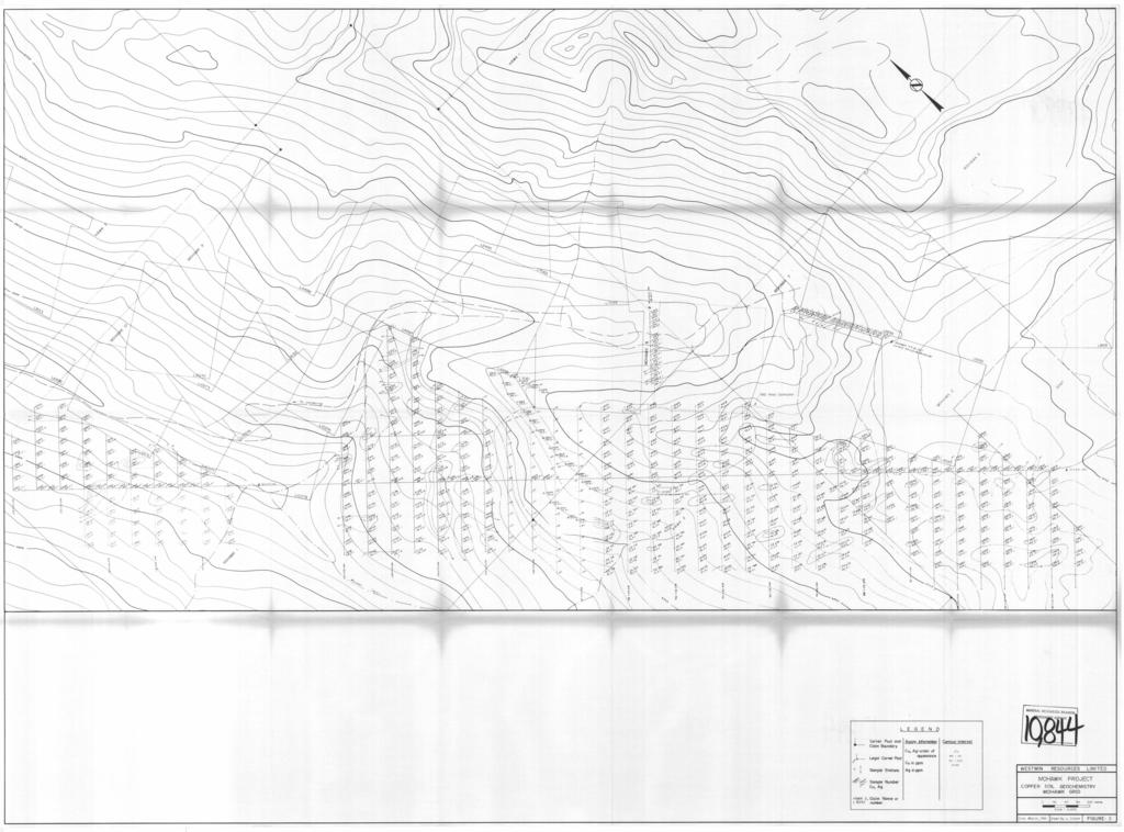
3 ~ LIST OF MAPS PAGE 1) Location Map 2a 2) Silver Soil Geochemistry, Mohawk Grid in pocket 3) Copxr Soil Geochemistry, Mohawk Grid n 4) Lead Soil Geochemistry, Mohawk Grid n 5) Zinc Soil Geochemistry, Mohawk Grid I 6) Silver Soil Geochemistry, Northwest Area " 7) Copper Soil Geochemistry, Northwest Area n 8) Lead Soil Geochemistry, Northwest Area 9) Zinc Soil Geochemistry, Northwest AKea
4 INTRODUCTION The Hawk, Pool, Fiver and Mohawk claims are located 50 km southeast of Revelstoke, B.C. and 6 km east of the north end of Upper Arrow Lake (Figure 1). The claims extend southeast from the former community of Camborne, B.C. along Mohawk Creek. Access is by paved highway and gravel road south from Revelstoke. The area is within the rugged Selkirk Mountains and elevations range from 1,700 feet at Camborne to peaks in excess of 8,000 feet. me 1982 soil sampling was on steep, generally heavily forested (cedar, fir and hemlock) slopes between 3,000 and 6,000 feet. Prospectors located numerous high grade vein Occurrences on Poole and Mohawk Creeks by These include the Beatrice, Silver Dollar, Gillman, Spider, Eclipse, Mohawk, Moscow, Conmore and other veins. These are held by a patchwork of Crown granted claims and bordered by the Westmin-owned Mohawk Group. An option agreement with Wiltshire Industries was concluded by Westmin on Crown granted claims Lot 4500 (Moscow), Lot 4572 (Fresno), Lot 4573 (Bluebird #2), Lot 4763 (Excelsior), Lot 5170 (Eclipse), Lot 5675 (St. JoP), Lot 5677 (Conmore), Lot 9137 (Emerald), Lot (Pipestem), Lot (B and J) and Lot (W.V. Fraction). The Spider Xine was the only significant producer; operated by Newmont, it produced 138,475 tons between with a recovery grade of Aujton, Ag/ton, 8.60 percent Pb, 9.14 percent Zn. A soil geochemical survey begun in 1980, was extended in 1981 and again in New grids were established on the Crown granted claims north of Poole Creek. Field work was carried out between July 25 and August 19, 1982 and comprised 2.1 km of baseline preparation, collection of 374 soil samples and building a cat trail to soil anomalies found in 1981 on Hawk 2 and Hawk 3.
5 - 2 - REGIONAL SETTING The area is underlain by the lower Paleozoic Lardeau Group (Read and Wheeler, 1976). The mafic volcanic Jowett Formation is overlain by the clastic sedimentary Broadview Formation. These are tightly folded about gently southeast or northwest dipping fold axes and the Mohawk area lies near the crest of the Silvercup Anticline. Silvercup Fault is a regionally extensive feature apparently produced by shear on the northeast limb of the anticline. Vein structures may be subsidiary features related to development of the Silvercup Anticline and Fault. The quartz veins are mineralcqlcally simple. Galena, sphalerite and pyrite are the principal sulpkides with variable tetrahedrite, arsenopyrite and chalcopyrite. The 6.4 km long Mohawk baseline was extended 300 m further on Pool 3 at 315' and soil lines from it extended to Sunshine Columbia's Crown granted claims (Lot in particular). Soil sampling was carried out on lines 115 to 121 on Mohawk 1, west of the Mohawk baseline. The East Mohawk baseline was extended 200 rn at 070'. east of Mohawk Creek on Hawk 3, and new lines were run at 3, 5, 7 and 8+00E. Three new baselines were established. The small Eclipse grid with a 200 m long baseline that trends 000' is centred on the Eclipse vein on Lot 5170 near Poole Creek. The Moscow baseline originates on Lot directly across Poole Creek from the Eclipse grid. It extends 600 m at 000'. The Red Horse baseline also lies north of Poole Creek and extends 800 m at 010". Soil samples were collected from the B-horizon in mattock-dug holes from sites 25 m or 50 m apart (as indicated on the maps) on lines spaced 100 m apart. All samples were analyzed by Chemex Labs using standard total extractable metal techniques and atomic absorption.
6 I BRITISH COLUMBIA 1 I, I i I i I I I f* I f
7 Y F c ir: I-,/.
8 - 3 - SOIL GEOCHEMISTRY (a) Mohawk Grid, Lines The geochemical expression is very subdued. A modest anomaly at on the baseline was not extended by the 1982 sampling. (b) Mohawk Grid, Lines Here too, soil values are fairly flat. values on line 143 were not extended. Encouraging silver (c) East Mohawk The 1982 results limit considerably the Pb, Zn, Ag anomaly foud in 1981 in the central area of the grid. Lines 5 and 7 res2ectively below and above the 1981 anomaly gave lower soil values. The PS response is tightly focused on lines 5 and 6E at 8+50N, peak value of 270 ppm. Zinc is coincident (340 ppm peak value) with lead but silver is rather diffuse and the best response (2.8 ppm from a 1981 site) is displaced downslope and may not be directly related to the Pb/Zn anomaly. An incompletely defined Pb/Zn anomaly at the northwest margin of the 1981 survey, near Mohawk Creek, is confirmed by the 1982 survey but is still broad and open. Values are up to 300 ppm Pb and 750 ppm Zn. Surprisingly Zn is displaced upslope from Pb. There are no significant associated Ag values. The copper response is subdued over the entire grid. (a) Mohawk, Red Horse, Eclipse Grids Results from initial sampling in this area are distinctly disappointing, considering that several mineralized vines are known. Copper, lead and silver do not exceed background values. A few high zinc values OCCUE along or close to the Moscow baseline.
9 - 4 - CAT TRAIL AND SOIL ANOMALY FOLLOW-UP Two soil anomalies located by the 1981 survey were investigated by building a cat trail to the site to provide access and rock exposure. One anomaly is located on line 99 NW at 2+00SW at an elevation of 6,500 feet. It is a single sample site anomaly in Cu, Pb and Ag with more extensive Zn, the values reported are 550 ppm Cu, 130 ppm Pb, 980 ppm Zn, 2.9 ppm Ag. The cat trail to the site was built with a D-6 cat and is about 1.5 km long, extending northwesterly from the Mohawk Creek/Beatrice Mine road. Local b&rock comprises phyllitic to schistose argillites and siltstones that are strongly foliated and crenulated by a second deformation. The style of minor folds is tight isoclinal with sheared hinges. There are' numerous 2ilational quartz veins, some with minor pyrite. A rusty seep and ferricrete deposit were noted near the anomalous soil site. A depression parallel to the hill, trending at 126' was investigated as a possible mineralized structure but nothing significant was found. Resampling the 1981 soil site produced lower but still anomalous values that drop off markedly within 10 m. Results of follow-up sampling are shown on the sketch overleaf. The second soil anomaly that was examined lies on lines 127 to 129 on the Mohawk grid at sites JE 586, 588, 589 and 608. About 300 m of cat trail was built to the area from the Mohawk Creek road at an elevation of about 4,500 feet. Only dark argillaceous phyllites were found and no further sampling was done. ECLIPSE TRENCHING The Eclipse vein outcrops on the south side of Poole Creek 550 m below the Mohawk Creek junction. Hand trenching, drilling with a gas drill, blasting and mucking, were carried out to achieve better exposure. The vein is localized on a sheared contact between black graphitic phyllite and greenstone. Vein orientation varies from 000" to 020' and dips 70' east. In the trench the vein is 5 m wide with several bands of coarse massive pyrite and minor coarse sphalerite and galena. Some 15,000 tons of the Spider Mine's 139,000 production tonnage came from the Eclipse vein.
10 - 5 - to baseline k - XZ z Trend of depression *2-14 JE x parallel to hillside at 126" 10 m x 2-19 (Rusty seep) soil line at 045' cu - Pb - zn %
11 - 6 - CONCLUSIONS Effectiveness of soil geochemistry to locate polymetallic veins in the Mohawk area is in question. An area north of Poole Creek, largely underlain by mafic volcanic rocks but including the Conmore and Moscow veins and possible extension of several other veins, gave very minimal geochemizal response. The single exception is a linear zinc anomaly along the Mohawk baseline that corresponds to the trend of several known veins. Furthermore, follow-up of 1981 soil anomalies did not locate evidence of mineralization. Instead the Source appears to be high background argillaceous metasedimentary rocks.
12 - 7 - APPENDIX 1 STATEMENT OF EXPENDITURES on Mohawk 1, 8 Fr, 9 Fr, 10 Fr, Hawk 2, 3, Pool 3, 5 Fr, Fiver 2, Lot 4500, 4572, 4573, 4763, 5170, 5675, 5677, 9137, Work Period: July 25 - August 19, 1982 SALARIES : Don Dudek (project organization, road location, soil anomaly follow-up) 11 $100 $ l, Doug Vanhelden (soil sampling, grid preparation, road location) 15 $ Pat Meade (grid preparation, soil sampling, mucking trench) 9 $ Jim Eenkooren (grid preparation, soil sampling, mucking trench) 11 $ Harlan Meade (supervision) 2 $125 FIELD EQUIPMENT:
13 -8- SOIL GEOCHEMISTRY: 314 soil $5.085 for Ag, Cu, Pb, Zn analyses (Chemex Labs, North Vancouver) $ 1, Sample shipping TRANSRJ2TATION: Truck (4 x 4) and trailer rental Fuel 1, ROAD CONSTRUCTION: Contracted to J & E Logging of Nakusp: Hauling equipment, 6 $55 D-6 cat, 60 $ , CAMP COSTS: Groceries, travel costs Camp equipment 1, REPORT PREPARATION: Drating, 9 $160 Writing, typing 1, $14,933.46
14 -9- APPENDIX 2 STATEMENT OF QUALIFICATIONS I, PAUL J. WOJDAK of the Municipality of Delta, Province of British Columbia, hereby certify : 1. That I am a geologist residing at th Avenue, Delta, British Columbia with a business address at Suite 904, 1055 Dunsmuir Street, P.O. Box 49066, Four Bentall Centre, Vancouver, British Columbia V7X 1C4 2. That I graduated with a B.Sc. (Honours) in Geology and Chemistry from McMaster University, Hamilton, Ontario in 1971 and with a M.Sc. in Geology from the University of British Columbia in That I am a member of the Geological Association of Canada. 4. That I have practised geology with Cominco Limited and Westmin Resources Limited from 1974 to Dated this 12 day of November 1982 at Vancouver, British Columbia. P. J. wojdak, M.Sc.
15 BIBLIOGRAPHY READ, P. B. & WHEELER, J. 0. (1976), Geology of Lardeau West-Half, B. C.; G.S.C. Open File 432.

16
17
18

19

20

21

22
23
RECONNAISSANCE GEOCHEMICAL SURVEY
 RECONNAISSANCE GEOCHEMICAL SURVEY LEGAL, RITA, LOUISE FR. (CHAPLEAU GROUP) REVERTED CROWN GRANTS CHAPLEAU CREEK AREAJ, SLOC& MINING DIVISION 82 F/11W Lat: 49'44" Long: 117"22'W MINERAL RESOURCES BRANCH
PROSPECTORS ASSISTANCE PROGRAM MINISTRY OF ENERGY AND MINES
 BRITISH COLUMBIA PROSPECTORS ASSISTANCE PROGRAM MINISTRY OF ENERGY AND MINES GEOLOGICAL SURVEY BRANCH PROGRAM YEAR: 1999/2000 REPORT #: PAP 99-l 6 NAME: KIM ANSCHETZ PROSPECTORS TlEPORT on the 99 LOUIS
for the Greenwood Mining Division, B.C. NTS 82E/7W Latitude 49' 27' W, Longitude 118' 5 Prepared by a= D. Dylan Watt, B.Sc.
 t. b LOGnO: 37~ -08 m. ACTIO#: for the AMP AMP 2 AMP 3 t AMP 4 CLAIMS Greenwood Mining Division, B.C. NTS 82E/7W Latitude 49' 27' W, Longitude 8' 5 %E c,w zc *& a w Prepared by a= -4c. D. Dylan Watt, B.Sc.
PRECIOUS METALS. owner. JMT Services Corp. GEOCHPlICAL SAMPLING CHELASLIE WCE, NORTH CENTRAL, B.C. OMINECA MINING DIVISION NTS 93F/5E & 6W
 PRECIOUS METALS REPORT ON 1980 RECONNAISSANCE GEOCHPlICAL SAMPLING CHELASLIE WCE, NORTH CENTRAL, B.C. OMINECA MINING DIVISION NTS 93F/5E & 6W LATITUDE 53O28 N LONGITUDE 125O31 W DATES Qp WORK: JULY 10
ASSESSMENT REPORT ON THE PEAVINE PROJECT. DGW & Associates # Alberni Street, Vancouver, British Columbia, V6E 4V2
 ASSESSMENT REPORT ON THE PEAVINE PROJECT KAMLOOPS MINING DIVISION BRITISH COLUMBIA NTS 082M 12 Latitude 51 36' 19.0"North -- Longitude --119 47' 27.0"West UTM Zone 11, NAD 83 5720827N 306744E Prepared
UNION MINIERE EXPLORATIONS AND MINING CORPORATION LIMITED ASSESSMENT REPORT ON FITINAT MINERAL CLAIM. Alberni Mining Division Record No.
 M F )( UNION MINIERE EXPLORATIONS AND MINING CORPORATION LIMITED Suite 200, 4299 Canada Way, Burnaby, B.C. V5G 1 H4 Telephone (604) 437-9491 ASSESSMENT REPORT ON GEOCHEMICAL SOIL SURVEYS AND ROCKSAMPLING
ASSESShAENT REPORT Mines and Petroleum Resources. Department of. No* JIMMY MINERAL CLAIM FRANKLIN CREEK AREA, GREENWOOD M. D.
 GEOCHEMICAL REPORT ON JIMMY MINERAL CLAIM FRANKLIN CREEK AREA, GREENWOOD M. D. Lat. 49'35' OON, N.T.S. Long. 118O22' 00W 82-E-9 July 18-21, 1974 Vancouver, B.C. J.J. McDougall, P.Eng. July 21, 1974 * Department
The Cobalt Rainbow. Airborne geophysical maps show that a north trending aeromagnetic high suggests further undiscovered mineralisation.
 The Cobalt Rainbow The property is located on Greenstone Creek, approximately 4.8 kilometres south west of the creek mouth. The property is located about 24 km due west of Campbell River, in the east-central
Prospecting Report 'S Office i DB Property, B.C. -J Negro Creek Nelson Mining District NTS 82F.050. Operator: Kootenay Gold Inc.
 . '.' I"' i9 12 Prospecting Report 'S Office i DB Property, B.C. -J Negro Creek Nelson Mining District NTS 82F.050 Operator: Kootenay Gold Inc. Owner: Darlene Lavoie Work Performed Summer of 2007 Report
1 FILMED 1. FILE NO:!..rsrru -* -. GRAND TWO CLAIM
 FILE NO:!..rsrru -* -. GRAND TWO CLAIM REPORT ON 1993 ASSESSMENT WORK GRAND TWO CLAIM REC. NO. 301849 NELSON MINING DIVISION NTS MAP SHEET 82F6/W 49 25'51" NORTH 117 18'08" WEST 1 FILMED 1 AUTHOR: R. Jordan,
NTS 93L/9W GEOCHEMICAL AND GEOPHYSICAL REPORT MONA CLAIM OMINICA MINING DIVISION. Lati tude 54036'N; Longitude 'W
 GEOCHEMICAL AND GEOPHYSICAL REPORT ON MONA CLAIM OMINICA MINING DIVISION Lati tude 54036'N; Longitude 126018'W NTS 93L/9W April 1981 Paul Plicka Consulting Geologist LOCATION MAP INTRODUCTION TABLE OF
GEOLOGICAL BRANCH ASSESSMENT REPORT 12. FItE NO: ACTION: THE GOLDEN MINING DIVISION, GOLDEN, Including THE NTS MAP; M82K/15W
 ACTION: FItE NO: Including 1990 GEO-CHEM SURVEY RESULTS -- THE AVD CLAIMS - THE GOLDEN MINING DIVISION, GOLDEN, B.C. NTS MAP; M82K/15W Lat. 50 deg. 55 Min. Long 116 deg. 55 min. For GEOLOGICAL BRANCH ASSESSMENT
for the Greenwood Mining Division, B.C. NTS 82E/7W 29' W, Longitude 118' 53' N Prepared by D. Dylan Watt, B.Sc.
 for the FltE NO: u VOLT 1, VOLT 2, VOLT 3, & VOLT 4 CLAIMS Greenwood Mining Division, B.C. NTS 82E/7W Latitude 49' 29' W, Longitude 118' 53' N Prepared by D. Dylan Watt, B.Sc. #309-1996 Trutch Street Vancouver,
ASSESSMENT REPORT GEOLOGICAL BRANCH. 50' 23 'North. GEOLOGICAL and GEOCHEMICAL SURVEYS ON THE. PUTNAM PROPERTY (Putnam Mineral Claim)
") GEOLOGICAL and GEOCHEMICAL SURVEYS ON THE PUTNAM PROPERTY (Putnam Mineral Claim) VERNON MINING DIVISION, B.C. GEOLOGICAL BRANCH ASSESSMENT REPORT NTS : Latitude: 82L17W 50' 23 'North LOCATION, ACCESS,
GEOLOGICAL and GEOCHEMICAL SURVEYS ON THE PUTNAM PROPERTY (Putnam Mineral Claim) VERNON MINING DIVISION, B.C. GEOLOGICAL BRANCH ASSESSMENT REPORT NTS : Latitude: 82L17W 50' 23 'North LOCATION, ACCESS,
49" 3-4 I4 I \ Y 59 tj
 ASSESSMENT REPORT Mary 4 FORT STEELE M.D. NTS 82G/5W 49" 3-4 4 \ Y 59 tj Owner: St. Eugene Mining Corporation Limited Operator : St. Eugene Mining Corporation Limited Author: John R. Wilson Date Submitted:
GEOCHEMICAL REPORT ON THE YEP CLAIMS, Clinton Mining Division. P.E. Fox, PhD. P.Eng.
 CLNTON 1 MNNG RECORDER GEOCHEMCAL REPORT ON THE YEP CLAMS, Clinton Mining Division P.E. Fox, PhD. P.Eng. Fox Geological Consultants Ltd 204-635 Victoria St. Kamloops, B. C. August 5, 1974 Work done: Juge
Work performed between August 1 and December 1, 1975 COMINCO LTD. WESTERN DISTRICT NTS 93 '(~15 EXPLORATION GEOCHEMICAL SURVEY THE CRY AND CAB CLAIMS
 COMINCO LTD. EXPLORATION WESTERN DISTRICT NTS 93 '(~15 GEOCHEMICAL SURVEY ON THE CRY AND CAB CLAIMS CRIN PROPERTY Work performed between August 1 and December 1, 1975 NICHOLAS L. SZABO TABLE OF CONTENTS
Reconnaissance. Of the. Denis mineral claims. Situated at Kilometer 844 of the Alaska Highway. Liard Mining Division. Northeastern British Columbia
 Reconnaissance Of the Denis mineral claims Situated at Kilometer 844 of the Alaska Highway Liard Mining Division Northeastern British Columbia N.T.S. 94M.075 Latitude 59 42 25 Longitude 127 13 12 Field
R.A. COMINCO LTD. EXPLORATION NTS: 92H/16. WESTERN DISTRICT January 6, 1982 ASSESSMENT REPORT 1981 SOIL GEOCHEMISTRY ON THE TROUT PROPERTY
 COMINCO LTD. EXPLORATION NTS: 92H/16 WESTERN DISTRICT January 6, 1982 ASSESSMENT REPORT 1981 SOIL GEOCHEMISTRY ON THE TROUT PROPERTY (Trout 1 and 6 Claims) SIWASH LAKE AREA, SIMILKAMEEN M.D., B.C. (Work
NEW HAZELTON, OMINECA M.D.,
 PROSPECTING REPORT JUDI 1 TO 6 MINERAL CLAIMS NEW HAZELTON, OMINECA M.D., B.C. MAP 93M/4E, LAT. SS014'N, LONG. 127'33'W OWNED BY: A. L'ORSA ANTHONY L'ORSA Smithers, B.C. 21 February, 1981 TABLE OF CONTENTS
cpw 6. E. Spencer Engineering Ltd. HANNA 9 M. C. 104 REP 0 RT DIAMOND DRILLING PROGRAMME LIARD MINING DISTRICT, K.T.S. FOR TAURUS RESOURCES LTD.
 6. E. Spencer Engineering Ltd. LlJ REP 0 RT ON DAMOND DRLLNG PROGRAMME cpw HANNA 9 M. C. LARD MNNG DSTRCT, K.T.S. 104 P@g FOR TAURUS RESOURCES LTD. BY B. E. SPENCER, P. ENG. B. E. SPENCER ENGNEERNG LTD.
VANCOUVER, B.C. Tri 082F/ F/059
 GEOCHEMCAL REPORT t MAY L, 2006 Whbpper Mineral Claims Ailsa Lake Area Gold comm~ss16fl8f"s Offim on Mining Division VANCOUVER, B.C. Tri 082F/058 082F/059 3792 E 5486438 N Operator Kootenay Gold nc. Suite
NTS 082F03SW N W U E N
 Prospecting Report JOCELYN CLAIM NTS 082F03SW N49 09 51 W 117 14 04 11U 482906E 5445737N NELSON MINING DIVISION Martin Ross PO Box 323 Salmo BC V0G 1Z0 Jan 31, 2012 PROSPECTING REPORT JOCELYN MINERAL CLAIM
GEOPHYSICAL ASSESSMENT REPORT (TOP & BOTTOM CLAIMS) MCINTYRE LAKE. VERNON MINING DIVISION, B-Cm
 MCINTYRE LAKE. VERNON MINING DIVISION, B-Cm") GEOPHYSICAL ASSESSMENT REPORT on the TOP PROPERTY (TOP & BOTTOM CLAIMS) MCINTYRE LAKE VERNON MINING DIVISION, B-Cm NTS : Latitude: 50'04' North Longitude: Owner: Consultant : Author : 118'33 ' West Brican
GEOPHYSICAL ASSESSMENT REPORT on the TOP PROPERTY (TOP & BOTTOM CLAIMS) MCINTYRE LAKE VERNON MINING DIVISION, B-Cm NTS : Latitude: 50'04' North Longitude: Owner: Consultant : Author : 118'33 ' West Brican
ASSESSMENT REPORT 2009 PROSPECTING PROGRAM. Prodigy (520481) Mineral Claim NTS 82K/13E LATITUDE NORTH LONGITUDE W
 Mineral Claim NTS 82K/13E LATITUDE NORTH LONGITUDE W") ASSESSMENT REPORT 2009 PROSPECTING PROGRAM Prodigy (520481) Mineral Claim REVELSTOKE MINING DIVISION NTS 82K/13E LATITUDE 50 46 00 NORTH LONGITUDE 117 35 00 W OPERATOR: MANSON CREEK RESOURCES LTD. PROPERTY
ASSESSMENT REPORT 2009 PROSPECTING PROGRAM Prodigy (520481) Mineral Claim REVELSTOKE MINING DIVISION NTS 82K/13E LATITUDE 50 46 00 NORTH LONGITUDE 117 35 00 W OPERATOR: MANSON CREEK RESOURCES LTD. PROPERTY
1 CLAIMS GEOPHYSICAL REPORT ON BOYAL SITUATE NORTHEAST OF TILLICUM MOUNTAIN GOLD AREA BURTON - NAKUSP SIQCAEJ MINING DIVISION
 GEOPHYSICAL REPORT ON BOYAL 1 CLAIMS SITUATE NORTHEAST OF TILLICUM MOUNTAIN GOLD AREA BURTON - NAKUSP SIQCAEJ MINING DIVISION CONSULTING GEOLOGIST AUGUST 1983 VANCOUVER B *C INDEX INTRODUCTION ooa,.eoaaa.aaaoaaooaoa~ao~o
Summary of Rover Metals Geologic Mapping Program at the Up Town Gold Project, Northwest Territories
 October 13, 2017 Summary of Rover Metals Geologic Mapping Program at the Up Town Gold Project, Northwest Territories Vancouver, British Columbia, Canada - Rover Metals Corp., Rover, is pleased to provide
compietea since tnat date, and wnicn comprisea btage I ot tne recommended
 compietea since tnat date, and wnicn comprisea btage I ot tne recommended four-stage program. GEOLOGY & MINERALIZATION The property situate6 on the southeast slope of Nickel Plate Mtn., and within the
BALFOUR MINING LTD. (N.P.L.) HAM GROUP 92-P-6, CLINTON M. D.8 B. C. Lat 51 17'N, GEOCHEMICAL REPORT. V. CUKOR, P. Eng.
 HAM GROUP 92-P-6, CLINTON M. D.8 B. C. Lat 51 17'N, GEOCHEMICAL REPORT. V. CUKOR, P. Eng.") 34q '7 BALFOUR MINING LTD. (N.P.L.) HAM GROUP 92-P-6, CLINTON M. D.8 B. C. Lat 51 17'N, Long 12lo14'W GEOCHEMICAL REPORT, V. CUKOR, P. Eng. January 31, 1972 TABLE OF CONTENTS 1. INTRODUCTION 2. PROPERTY,
34q '7 BALFOUR MINING LTD. (N.P.L.) HAM GROUP 92-P-6, CLINTON M. D.8 B. C. Lat 51 17'N, Long 12lo14'W GEOCHEMICAL REPORT, V. CUKOR, P. Eng. January 31, 1972 TABLE OF CONTENTS 1. INTRODUCTION 2. PROPERTY,
GEOCHEMICAL REPORT THE 82M/12 FH GROUP BIRCH ISLAND, B.C. S1 119O NOW. ROYAL CANADIAN VENTUR 3S LTD. By: Vollo, P. Eng. N.B. Pay 28th, 1969.
 c GEOCHEMICAL REPORT ON THE 82M/12 FH GROUP AT BIRCH ISLAND, BC S1 119O NOW BY ROYAL CANADIAN VENTUR 3S LTD NB By: Vollo, P Eng Pay 28th, 1969 Approximately 700 samples were collected over 14 miles of
PROSPECTING REPORT THE WALLACE CLAIM OMENICA MINING DIVISION. 54" x6" 3.d d. for. Reako Exlorat ions Ltd. Wallace Rev. C.G.
 PROSPECTING REPORT ON THE WALLACE CLAIM OMENICA MINING DIVISION 54"44 14 1x6" 3.d d by David A. Howard P.Eng. for Reako Exlorat ions Ltd. Claim Locat ion Wallace Rev. C.G. #1560 Dome Mountain Area 9 3
Cominco ltd. REPORT OF GRID "C" GEOCHEMICAL SURVEY ON VINE 1 CLAIM, VINE 1, 25, 27 CLAIM GROUP Fort Steele Mining Division
 GOVERNMENT OFFICE Cominco ltd. EXPLORATION DIVISION REPORT OF GRID "C" GEOCHEMICAL SURVEY ON VINE 1 CLAIM, VINE 1, 25, 27 CLAIM GROUP Fort Steele Mining Division Submitted by: E.W. BATCHELOR Cominco Ltd.
Geochemical Assessment Report. on the. Situated Nineteen Kilometres rth-northeast of Hope, B. C. in the. New Westminster Mining Division
 7 I Geochemical Assessment Report r on the r- I 1 Norm 1 to Norm 4 Mineral Claims c - I - 7 Situated Nineteen Kilometres rth-northeast of Hope, B. C. in the New Westminster Mining Division itude 49*32'N.,
PHYSICAL WORK REPORT. the BAY CLAIMS. Omineca Mining Division Smithers, British Columbia N.T.S. 93E 13E/W
 PHYSICAL WORK REPORT the BAY CLAIMS Omineca Mining Division Smithers, British Columbia a N.T.S. 93E 13E/W LATITUDE: 53 57 00 N I LONGITUDE: 127 45 OO W for Home Ventures Ltd. 1201-675 West Hastings Street
Serengeti Resources Inc GEOCHEMICAL REPORT ON THE SHADOW PROPERTY a.
 Serengeti Resources Inc. 2004 GEOCHEMICAL REPORT ON THE SHADOW PROPERTY a. Located in the Johanson Lake Area Omenica Mining Division NTS 94D/9 6 degrees and 32 minutes North Latitude 126 degrees and 2
ASSESSMENT REPORT PROSPECTING PROGRAM ION/DIRTY JACK PROPERTY NELSON MINING DIVISION N.T.S. MAP SHEET 82F.023 UTM COORDINATES N E
 ASSESSMENT REPORT PROSPECTING PROGRAM ION/DIRTY JACK PROPERTY NELSON MINING DIVISION N.T.S. MAP SHEET 82F.023 UTM COORDINATES 5454800N - 0455235E Work Performed Summer 2007 OWNER >* ' Tom Kennedy >8 404-22
sq N & %%.& GEOPHYSICAL CONSULTING rr SERVICES LTD. $%& Long. 118o3OtW N.T.S. 82 E/15 -I- AUTROR: Glen E. Whi*e, B.Sc., P. %g.
 -\ GEOCHEMICAL EXPORT.,~.,~..'.. AMORE MINERALS 1NCORPOR;ITZC,' ~. 3rd fl5 Geo 3. and 2 mineral claims, Vernon- ~ $lining Division, B. C. Lat. 49 47'T?,,/ Long. 118o3OtW N.T.S. 82 E/15 -I- AUTROR: Glen
Location/Identification
 MINFILE Detail Report BC Geological Survey Ministry of Energy, Mines and Natural Gas and Responsible for Housing Location/Identification MINFILE Number: 092L 178 National Mineral Inventory Number: 092L14
SOIL GEOCHEMISTRY. OK-ll AND OK-Ill MINERAL CLAIMS MOUNT THOEN AREA OMINECA MINING DIVISION, B.C. NTS 93 MI6 E & 7 W
 SOIL GEOCHEMISTRY OK-ll AND OK-Ill MINERAL CLAIMS MOUNT THOEN AREA OMINECA MINING DIVISION, B.C. NTS 93 MI6 E & 7 W LATITUDE 55O23'N, LONGITUDE 127 01W Locke B. Goldsmith, P.Eng. Consulting Geologist December
CARIBOO - GRIZZLY ZINC PROJECT
 CARIBOO - GRIZZLY ZINC PROJECT The Grizzly Lake or Cariboo Zinc property straddles the gravel Weldwood 8400 logging road in the Grizzly Lake area about 55 kilometres northeast of Likely. Roads constructed
32?un North of Hope, B.C.,
 Geological Reconnaissance Assessment Report on portions of the Gilt Creek Group (Mike, C.G., Julie, and Gilt Mineral Claims) Situated 32?un North of Hope, B.C., New Westminster Mining Division N 'P 97H/11W
2013 GEOLOGICAL ASSESSMENT REPORT SHERIDAN HILL PROPERTY
 2013 GEOLOGICAL ASSESSMENT REPORT ON THE SHERIDAN HILL PROPERTY NEW WESTMINSTER MINING DIVISION BRITISH COLUMBIA NTS 092G07 49 16 31 NORTH LATITUDE, 122 39 48 WEST LONGITUDE PREPARED FOR Sheridan Hill
Geo chemi c a1 Rep or t SILVER KING FAST GROUP. H. S. Lazenby Geologist. Vancouver, B.C. 16 November 1967
 Geo chemi c a1 Rep or t on SILVER KING FAST GROUP 1967 Vancouver, B.C. 16 November 1967 H. S. Lazenby Geologist Contents Introduction P. 1 Method of Survey P. 1 Interpretation of Results p. L&2 Statement
The MAPLE BAY PROJECT Copper Silver - Gold
 The MAPLE BAY PROJECT Copper Silver - Gold Good grade and tonnage potential within close proximity to Tidewater The Maple Bay Copper Silver Gold Project covers highly favourable geological host rocks of
ASSESSMENT REPORT ON THE VLF-EM SURVEY. Trail Creek Mining Division NTS: 82 F/4 W Longitude: 1 17' 49' 50" Latitude: 49O 03' 40"
 ASSESSMENT REPORT ON THE JERO 5 MINERAL CLAIM ROSSLAND, BRJTISH COLUMBIA VLF-EM SURVEY Trail Creek Mining Division NTS: 82 F/4 W Longitude: 1 17' 49' 50" Latitude: 49O 03' 40" Owner: Operator: Author:
ASSESSMENT REPORT MAGNETOMETER SURVEY GOLDEN ROD, GOLDEN ROD #2. Long.: General Delivery, Vananda, B. C.
 ASSESSMENT REPORT MAGNETOMETER SURVEY GOLDEN ROD, GOLDEN ROD #2 t=/ NTS 92~110w Lat.: Long.: 49O 44' N 124O 34' W Owner: E. Johanson General Delivery, Vananda, B. C. Operator: Rhyolite Resources I nc.
ON THE LOST GOLD PROPERTY
 ON THE LOST GOLD PROPERTY NELSON MINING DIVISION BRITISH COLUMBIA Latitude: 49 18 North Longitude: 117 29.West TRIM MAPS: 82F1023,033 NTS: 8tF/5,6 By: Fred Critchlow . TABLE OF CONTENTS r PAGE lutroduction
REPORT ON A GEOLOGICAL MAPPING AND PROSPECTING PROGRAM LOOK PROPERTY
 b KOKANEE EXPLORATIONS LTDI I WNO. 0 I- n c/ REPORT ON A GEOLOGICAL MAPPING AND PROSPECTING PROGRAM LOOK PROPERTY LOOK 1-31, 36-43 CLAIMS FORT STEELE MINING DIVISION CRANBROOK AREA N.T.S. 82G/5W + 4E E:
SOIL GEOCHEMISTRY TUFA MINERAL CLAIM SLOCAN MINING DIVISION ZINCTON, B.C. NTS 82K 3E LATITUDE 50"02'20"N, LONGITUDE 117'11'W
 SOIL GEOCHEMISTRY TUFA MINERAL CLAIM SLOCAN MINING DIVISION ZINCTON, B.C. NTS 82K 3E LATITUDE 50"02'20"N, LONGITUDE 117'11'W LOCKE B. GOLDSMITH, P.ENG., P.GE0. CONSlULTING GEOLOGIST OCTOBER 30,2001 TABLE
RE~ORT ON. J.F.V. MILLAR, P. Eng. GEOCHEMICAL SURVEY TIMBASKET AND MOGUL MINERAL CLAIMS. Kinbasket Lake, B. C. 51 degrees 118 degrees N.E.
 RE~ORT ON GEOCHEMICAL SURVEY TIMBASKET AND MOGUL MINERAL CLAIMS Kinbasket Lake, B. C. 51 degrees 118 degrees N.E. J.F.V. MILLAR, P. Eng. Lease held by J.F.V. MILLAR Work done Sept. 22 - Oct. 3, 1967. REPORT
NEW COBAR-STYLE COPPER DISCOVERY IN NSW
 ASX / MEDIA RELEASE 2 AUGUST 2011 NEW COBAR-STYLE COPPER DISCOVERY IN NSW Broad zone of copper-polymetallic mineralisation intersected at 4-Mile prospect Highlights: Wide zone of copper-silver-gold-lead-zinc
LAFOREST-HLAVA EXPLORATION SERVICES LTD. (705)
") !d LAFOREST-HLAVA EXPLORATION SERVICES LTD. (705) 268-25 I-) REPORT ON GEOLOGICAL MAPPING AND. ON THE HORNE CLAIM RECORD NO. 639 REVELSTOKE MINING DIVISION NTS 82 K/4W 'zr 'I LATITUDE 50' a"% LONGITUDE
!d LAFOREST-HLAVA EXPLORATION SERVICES LTD. (705) 268-25 I-) REPORT ON GEOLOGICAL MAPPING AND. ON THE HORNE CLAIM RECORD NO. 639 REVELSTOKE MINING DIVISION NTS 82 K/4W 'zr 'I LATITUDE 50' a"% LONGITUDE
51 46'N Latitude, 119'44'1;!
 COMI)!CO LTD. EXPLORATION NTS: 82 1'1/13E GEOCHEKICAL ASSESSMENT REPORT ON THE SI 1 MINERAL CLAIM in the Kamloops Mining Division 51 46'N Latitude, 119'44'1;! Longitude Work Period: June 25, 1979 - July
REPORT SOIL GEOCHEMICAL SURVEY. ATTYCELLEY NO. 2 GROUP (Attycelley Mineral Claims No. 7-10)
") REPORT SOIL GEOCHEMICAL SURVEY ATTYCELLEY NO. 2 GROUP (Attycelley Mineral Claims No. 7-10) Situated 7 miles east of north end of Thutade Lake, Omineca Mining Division British Columbia I Department of I
REPORT SOIL GEOCHEMICAL SURVEY ATTYCELLEY NO. 2 GROUP (Attycelley Mineral Claims No. 7-10) Situated 7 miles east of north end of Thutade Lake, Omineca Mining Division British Columbia I Department of I
Lat. 52' 43' N Long ' W
 &A exploration ltd MINING ENGINEERING GEOLOGY- GEOPHYSICS 4570 HOSKINS ROAD, NORTH VANCOUVER, 6. C. TELEPHONE (804) 985,7921 V7K 2R1 GEOLOGICAL AND GEOCHEMICAL REPORT on the BLUE CLAIMS Cariboo Mining
GEOPHYSICAL REPORT CHU CHUA PROJECT Green Mountain Group. KAMLOOPS MINING DIVISION NTS 92P/8E, 82M/5W Lat: 51'24' N Long: 120'00' w
 I GEOPHYSICAL REPORT CHU CHUA PROJECT Green Mountain Group KAMLOOPS MINING DIVISION NTS 92P/8E, 82M/5W Lat: 51'24' N Long: 120'00' w I rvm #.,_..._..._._._.- $...-...! 1 VANCOUVER, B.C. 1 G E 0 I, 0.G
GEOLOGICAL BRANCH ASSESSMENT RKBORT BEATY GEOLOGICAL LTD. REPORT ON A GEOCHEMICAL SURVEY OF THE PEAK-REKA-HOLD CLAIM GROUP.
 BEATY GEOLOGICAL LTD. Contract Geological Services 208-2786 West 16th Avenue Vancouver, B.C., Canada V6K 3C4 Telephone (604) 734-2774 REPORT ON A GEOCHEMICAL SURVEY OF THE PEAK-REKA-HOLD CLAIM GROUP. MONASHEE
A PRELIMINARY REPORT ON THE ZYMOST2 CLAIM GROtP, TERRACE, B.C.
 NATIVE EXPLORATIONS LTD. A PRELIMINARY REPORT ON THE ZYMOST2 CLAIM GROtP, TERRACE, B.C. INTRODUCTION': The Zymoetz claim group is, at present, held under option by Native Explorations Ltd.. On the 19th
510 W. HASTINGS STREET
 GEOCHEMICAL SOIL SURVEY OF THE DILLARD & MABEL AREAS BRITISH COLUMBIA PREPARED FOR : CYPRUS EXPLORATION CORPORATION LIMITED 510 W. HASTINGS STREET VANCOUVER,B.C. PREPARED BY: BARRINGER RESEARCH LIMITED
BLURTON CREEK NICKEL PROPERTY. (Minfile # 082LNW-039)
") 5489153 BLURTON CREEK NICKEL PROPERTY (Minfile # 082LNW-039) Mara Lake Area / Salmon Arm B.C NTS - 82L-11 (UTM 83/Z10, 357690E, 5614220N) Prepared by: Jim Cuttle, B.Sc., P.Geo. 86 Cloudburst Road Whistler,
5489153 BLURTON CREEK NICKEL PROPERTY (Minfile # 082LNW-039) Mara Lake Area / Salmon Arm B.C NTS - 82L-11 (UTM 83/Z10, 357690E, 5614220N) Prepared by: Jim Cuttle, B.Sc., P.Geo. 86 Cloudburst Road Whistler,
A New Direction. Copper-Gold Deposit at Thor TSX.V:COL. August 11, May 2013
 A New Direction Copper-Gold Deposit at Thor August 11, 2016 May 2013 TSX.V:COL FORWARD LOOKING STATEMENTS This presentation includes certain forward-looking information or forward-looking statements for
TABLE OF CONTENTS APPENDICES SUMMARY DRILL LOG STATEMENT OF QUALIFICATION STATEMENT OF EXPENDITURES LIST OF FIGURES
 ASSESSMENT WORK REPORT DIAMOND DRILLING PROGRAM AUGUST AND SEPTEMBER, 1980 ON CLAIMS Molly Tom 1-4 and 8 Omineca Mining Division NTS 93M/llU 55'35'N, 127"29'W by David A. Bending Owner: Operator: Texasgulf
58 l'gr'n 'E. Date: January 23, 1979 ASSESSMENT REPORT PLACER SAMPLING & JADE BOULDER EVALUATION PLACER LEASE Liard Mining Divison 1041/7E
 ASSESSMENT REPORT PLACER SAMPLING & JADE BOULDER EVALUATION PLACER LEASE 1711 Liard Mining Divison 1041/7E 58 l'gr'n 18 38'E Owner & operator: Cry Lake Jade Mines Ltd. Author: A.M. Homenuke, P.Eng. Date:
Gold Mountain Group Gold Mtn. A, B, C & D Mineral Claims Record Nos. 697, 698, 699 & 700. Island Mountain Cariboo Mining Division British Columbia
 GOLD POINT RESOURCES LTD. Geophysical Survey Gold Mountain Group Gold Mtn. A, B, C & D Mineral Claims Record Nos. 697, 698, 699 & 700 Island Mountain Cariboo Mining Division British Columbia Vancouver,
COMINCO LTD. GRID A VINE CLAIM GROUP. Fort Steele Mining Division 82G/5. Sulilnit t ed by :
 COMNCO LTD. EXPLORATON DVSON WESTERN DSTRCT REPORT ON GEOCHEMCAL SURVEY GRD A VNE CLAM GROUP Fort Steele Mining Division 82G/5 Sulilnit t ed by : E.W. BATCHELOR Cominco Ltd. Kootenay Exploration 2450 Cranbrook
CONTENTS. Location, Access and History...6. Tenure Status and Geology Regional Andy Property Geology Map...9
 TYPE OFWORK IN THIS REPORT EXTENT OF WORK (rn METRTC UNITS) ON WHICH CLAIMS PROJECT COSTS APPORTIONED (incl. support) GEOLOGICAL (scale, area) Ground, mapping Photo interpretation GEOPHYSICAL (line-kilometres)
FANCAMP EXPLORATION LTD.
 FANCAMP EXPLORATION LTD. Fancamp Exploration Ltd. Overview of Ontario Projects Prepared by: J. Kleinboeck, P.Geo. August 4 th, 2018 Dorothy Lake Project Comprised of 104 unpatented claims covering an
L FILMED I GEOLOGICAL BRANCH ASSESSMENT REPORT. on the. in the. A Geological Report. situated. Nelson Mining Division
 A Geological Report on the GOV 5 Claim situated 4 km north of Creston, B.C. in the Nelson Mining Division N.T.S. 82pF/7tEf Lat: 49m1 N Long: 116'4.5'W 24.8' Dates of Work: 11-1 September 1986 Date of Report:
GRISWOLD CREEK, B.C. 6 " GEOCHJ3lICAL REPORT
 GRISWOLD CREEK, B.C. 6 " GEOCHJ3lICAL REPORT AUTROR: W. Meyer, BSc. ENDORSED El!: John De Leen, BASc.* NASc., E.M., P. Eng. No. 3675 Vancouver, B.C. January 22nd, 1965. -I- During the period of July 27th
PHOENIX GEOPHYSICS LIMITED REPORT ON THE VLF-EM AND TOTAL FIELD MAGNETOMETER SURVEYS ON THE
 PHOENIX GEOPHYSICS LIMITED REPORT ON THE VLF-EM AND TOTAL FIELD MAGNETOMETER SURVEYS ON THE TAN CLAIMS, CHILLIWACK AREA NEW WESTMINSTER MINING DIVISION, BRITISH COLUMBIA FOR LORNEX MINING CORPORATION LIMITED
MEMORANDUM. Interpretation of Magnetic and Volterra-3DIP survey MC Claims
 11966 95A Avenue, Delta, BC V4C 3W2 Canada Tel +1 (604) 582-1100 www.sjgeophysics.com MEMORANDUM Date: September 13, 2017 From: To: SUBJECT: E. Trent Pezzot Bonanza Mining Corporation Interpretation of
CSA Mine Observations Applied to the Development of Regional Exploration Models
 CSA Mine Observations Applied to the Development of Regional Exploration Models 1 Introduction Recent work completed by the geology team has resulted in an improved understanding of the CSA mine system
12 tons of high-grade ore was mined from the No. 1 vein with an average grade of 13 g/t gold, 3,250 g/t silver and 23.3% lead.
 DUNWELL MINE GROUP The Dunwell Mine Group (Dunwell, Dunwell East, Bear River/MM and Silvershot properties), which includes the historic, past-producing Dunwell mine, is located 8 km northeast of Stewart
... TABLE OF CONTENTS APPENDIX. Page No. - Introduction... Location and Access. Claims... Topography and Vegetation Geology...
 ... Claims... Topography and Vegetation Geology... ntroduction... Location and Access Overburden... Field Procedure... Laboratory Procedure... Results and nterpretation Molybdenum... Zinc... Copper...
MtNERAL EXPLORATION CONSULTANTS ASSESSMENT REPORT MT. MILLIGAN AREA OMINECA M.D. Latitude: 55' 07' N Longitude: 123" 56' W NTS : 93 0/4 W.
 D. L. COOKE AND ASSOCIATES LTD. MtNERAL EXPLORATION CONSULTANTS ASSESSMENT REPORT 1989 PRELIMINARY GEOCHEMICAL SURVEY KC MINERAL CLAIMS MT. MILLIGAN AREA OMINECA M.D. Latitude: 55' 07' N Longitude: 123"
COMBINATION OF MMI AND ENZYME LEACH METHODS IN EXPLORATION FOR GOLD IN AN AREA OF THE CANADIAN SHIELD COVERED WITH GLACIAL SEDIMENTS: A CASE STUDY
 COMBINATION OF MMI AND ENZYME LEACH METHODS IN EXPLORATION FOR GOLD IN AN AREA OF THE CANADIAN SHIELD COVERED WITH GLACIAL SEDIMENTS: A CASE STUDY Nadia Yavorskaya 450 Bonner Ave., Winnipeg, MB, Canada
on the Diamond Drilling done on the LAKESIOE GROUP of Mineral Claims SLOCAN MINING DIVISION 82-F-14-W Long ' Lat '
 Assessment Work Report on the Diamond Drilling done on the LAKESIOE GROUP of Mineral Claims SLOCAN MINING DIVISION 82-F-14-W Long 117 22' Lat. 49 58' ADRIAN KESLER SILVERTON, B.C. operator LEVON RESOURCES
GEOLOGICAL MAPPING REPORT ON THE ASH MINERAL CLAIM OSOYOOS MINING DIVISION ASHNOLA RIVER MAP SHEET NTS M092,H019 MCBRIDE CREEK AREA, ASHNOLA RIVER,
 GEOLOGICAL MAPPING REPORT ON THE ASH MINERAL CLAIM OSOYOOS MINING DIVISION ASHNOLA RIVER MAP SHEET NTS M092,H019 LATITUDE 49 o O6, LONGITUDE 120 o 22 MCBRIDE CREEK AREA, ASHNOLA RIVER, KEREMEOS, B.C. CANADA
ASSESSMENT REPORT. Geochemical and Geological Surveys. on the. Gooch#1-4. Mineral Claims. Omenica Mining District NTS 93L/7W
 f- GEOLOGICAL BRANCH ASSESSMENT REPORT ASSESSMENT REPORT Geochemical and Geological Surveys on the Gooch#1-4 Mineral Claims Omenica Mining District NTS 93L/7W LAT: 54O25'W LONG: 126O26'W Operator: SMD
FILE NO. ASSESSMENT REPORT VLF-EM GEOPHY S I CS BUCK CLAIMS. Moyie River and Perry Creek Area FORT STEELE MINING DIVISION. NTS 82 F/8 E and 82 G/5 W
 FILE NO. ASSESSMENT REPORT on - VLF-EM GEOPHY S I CS BUCK CLAIMS Moyie River and Perry Creek Area FORT STEELE MINING DIVISION NTS 82 F/8 E and 82 G/5 W Latitude 49 27' N Longitude 116 03' W PETER KLEWCHUK
twd$ yqsi+hca
 -t@~cl--t,i twd$ yqsi+hca C ASSESSMENT REPORT ON THE OR0 1-5 CLAIMS NEAR GOLDBRIDGE, B.C. Lillooet Mining Division N.T.S. 92 J / 15 W Long. 122 51.5 W. Lat. 50 47.5 N. Owned by Levon Resources Ltd. Optioned
Montgomery Bedrock Geology 21d-Gowganda Formation: conglomerate, sandstone, siltstone, argillite
 Work Report 2014 Trenching Montgomery Township G-3303 Claim #4259384,4245818 Sault Ste. Marie Mining Division Michael & Yvon Gagne Montgomery Copper Property 1 P a g e 2 P a g e Montgomery Bedrock Geology
Survey. Prospecting, Geological Mapping. and E-M GOLDEN MINING DIVISION. Report on. RAD Mineral Claims. NTS Location - 82K/8W
 GOLDEN MINING DIVISION Report on Prospecting, Geological Mapping and E-M Survey RAD Mineral Claims NTS Location - 82K/8W Coordinates 116O 20' W, 50 20' N Operator - Cochrane Oil & Gas Ltd. Author - R.G.
T-1 Mines and Petroleum Resources
 Department of T-1 Mines and Petroleum Resources ASSESSfdEEdT REPORT NO..LC... 7.t... hlap... ... NTRODUCTON Y ' PERSONNEL.... GEOGRAPHY.... Location..... Access... Page 1 Page 2 Page 2 Page 2 Page 2 Topography...
BRITISH NEWFOUNDLAND EXPLORATION LIMITED PROSPECTING REPORT JR AND MARK CLAIMS LIARD MINING DIVISION, B. C. By: Michael G.
 BRITISH NEWFOUNDLAND EXPLORATION LIMITED PROSPECTING REPORT JR AND MARK CLAIMS LIARD MINING DIVISION, B. C. By: Michael G. Willia 6- "t f I - -- ---- --.--. Department af I Brinex Report No. ~74546,- NTS
M.U.T. CLAIMS GROUP C, SALMO AREA, B.C. WORK PERFORMED DURING MARCH, APRIL,. AUGUST, SEPTEMBER, NOVEMBER AND DECEMBER, 1977.
 REPORT ON GEOLOGICAL, PHYSICAL AND DRILLING WORK, M.U.T. CLAIMS GROUP C, SALMO AREA, B.C. WORK PERFORMED DURING MARCH, APRIL,. AUGUST, SEPTEMBER, NOVEMBER AND DECEMBER, 1977. V.M. RAMALINGASWAMY MARCH
GEOLOGICAL MAPPING OF SKARNS ON THE SHEEP AND EWE CLAIMS, TURNAGAIN RIVER, B.C. DURING THE 1979 SUMMER SEASON
 GEOLOGICAL MAPPING OF SKARNS ON THE SHEEP AND EWE CLAIMS, TURNAGAIN RIVER, B.C. DURING THE 1979 SUMMER SEASON CLAIMS: Sheep 1 to 4 Ewe 1, 3, 4 to 8 Lamb 12 Fraction Liard Mining Division, B.C. NTS 104
7 MILES WEST OF PORT HARDY, B.C.
 GEOPHYSICAL REPORT VERTICAL INTENSITY MAGNETOMEER SURVEY ON LUK CLAIMS, 7 MILES WEST OF PORT HARDY, B.C. 50' 127O SE BY R. E. SHIELDS UNDER SUPERVISION OF J. R. BILLINGSLEY FOR SECOND0 MINING LTD. (N.
3 I1 I I Ill 111 II! II 111 II Ill I IlE I I P I
 -7 3 1 1 11111111111111111111111111111111 ll 111! 111 111 111 111 111111111111111 ll 1111111 1 11111111111111 le P GEOCHEMCAL SURVEY OF THE KE AND D'ARCY CLAM GROUPS.. Similkameen Mining Division, B.C.
Elverdton Copper-Gold Project Ravensthorpe, Western Australia
 FOR SALE or JV Elverdton Copper-Gold Project Ravensthorpe, Western Australia Summary: The Elverdton Copper-Gold Project is located approximately 11 kilometres south-east of Ravensthorpe town, which is
Queensland Mining Corporation Limited
 Queensland Mining Corporation Limited ABN 61 109 962 469 ASX Release 29 th July 2011 Drilling Commenced at Duck Creek Copper-Gold Project, Cloncurry, North-west Queensland Highlights RC drilling has commenced
Gold c 8 Rl!TI I8 8 I0 n0 '8 Off VANCOUVER, B.C. btandard I Property
 ,- PROSPECTING REPORT For the 1 Gold c 8 Rl!TI I8 8 I0 n0 '8 Off ig@ VANCOUVER, B.C. btandard I Property I SALMON GOVERNMENT AGENT ARM I Tenure Number 554772 Revelstoke Mining Division, B.C. BCGS GRID
Mishi Lake Gold Property Mishibishu Lake Area, Wawa
 Mishi Lake Gold Property Mishibishu Lake Area, Wawa Location, Accessibility, Infrastructure and Local Resources The property is located 40 km west of Wawa, Ontario, in the Mishibishu Lake Area, Sault Ste.
The Aïn Kerma Gold Prospect (ONHYM) Tan Tan Province, Guelmin - Es Semara Region, Southern Morocco. Field Visit Report
 Tan Tan Province, Guelmin - Es Semara Region, Southern Morocco. Field Visit Report") The Aïn Kerma Gold Prospect (ONHYM) Tan Tan Province, Guelmin - Es Semara Region, Southern Morocco. Field Visit Report 1. Introduction The field visit took place on Wednesday, the 21 st July. It took place
The Aïn Kerma Gold Prospect (ONHYM) Tan Tan Province, Guelmin - Es Semara Region, Southern Morocco. Field Visit Report 1. Introduction The field visit took place on Wednesday, the 21 st July. It took place
121 deg 44' W and 53 deg 07' N
 M.R. #. R... VANCOUVER, B.C. REPORT ON THE WILLOW AND WILLOW I CLAIMS RECORD NO. 8475 AND 8476 CARIBOO MINING DIVISION NTS 93 H/4 121 deg 44' W and 53 deg 07' N 'W OWNER AND OPERATOR: RUZA RESOURCES LTD.
zccaw- d 4, I SUB- RECORDER 1 GEOLOGICAL IBIRANC)~ SEP ASSESSMENT REPORT FRENO: ACTION: 2[-;tc,u,eAAA RECEIVED M.R.#... $... VANCOUVER, B.C.
~ SEP ASSESSMENT REPORT FRENO: ACTION: 2[-;tc,u,eAAA RECEIVED M.R.#... $... VANCOUVER, B.C.") c ON THE LOGMI: /+dq(. m. BONBON MINERAL CLAIM ' ACTION: 2[-;tc,u,eAAA -- FRENO: h zccaw- d 4, FOR LUCIA SPECOGNA I SUB- RECORDER 1 RECEIVED SEP 25 1990 M.R.#... $... VANCOUVER, B.C. i BY MARINO SPECOGNA
c ON THE LOGMI: /+dq(. m. BONBON MINERAL CLAIM ' ACTION: 2[-;tc,u,eAAA -- FRENO: h zccaw- d 4, FOR LUCIA SPECOGNA I SUB- RECORDER 1 RECEIVED SEP 25 1990 M.R.#... $... VANCOUVER, B.C. i BY MARINO SPECOGNA
Negro Creek Fort Steele Minina Division. CRAIG KENNEDY Prospector
 AUG and SKAY Claims Negro Creek Fort Steele Minina Division NTS 82 F8/E Latitude 49O28 N Lonqi tude 116 Ol W BY CRAIG KENNEDY Prospector September 5, 1996 TABLE OF CONTENTS Page 1.00 INTRODUCTION 1.10
ASX / MEDIA RELEASE 6 MAY MILE SILVER-LEAD-ZINC DISCOVERY; HIGH GRADE SILVER-GOLD IN ROCK CHIPS AT RUBY SILVER
 ASX / MEDIA RELEASE 6 MAY 2011 4-MILE SILVER-LEAD-ZINC DISCOVERY; HIGH GRADE SILVER-GOLD IN ROCK CHIPS AT RUBY SILVER Highlights: Silver-lead-zinc discovery at 4-Mile; mineralisation intersected in all
Tricon Mining Ltd. 104 I/lE GEOLOGY AND DRILLING B.S. GROUP (B.S. 1&2) PROVENCHER LAKE LIARD MINING DIVISION 58' 16" 128' 40'W
 PROVENCHER LAKE LIARD MINING DIVISION 58' 16 128' 40'W") GEOLOGY AND DRILLING B.S. GROUP (B.S. 1&2) PROVENCHER LAKE LIARD MINING DIVISION 104 I/lE 58' 16" 128' 40'W OWNER & OPERATOR: WRITER: SUBMITTED: CRY LAKE JADE MINES LTD. A.M. Homenuke, P. Eng.(Geol.) November
GEOLOGY AND DRILLING B.S. GROUP (B.S. 1&2) PROVENCHER LAKE LIARD MINING DIVISION 104 I/lE 58' 16" 128' 40'W OWNER & OPERATOR: WRITER: SUBMITTED: CRY LAKE JADE MINES LTD. A.M. Homenuke, P. Eng.(Geol.) November
DÉCOUVERTE Positioned for Discovery in James Bay, Quebec. Investor Presentation, January 2018 by Danae Voormeij, MSc, PGeo
 DÉCOUVERTE Positioned for Discovery in James Bay, Quebec Investor Presentation, January 2018 by Danae Voormeij, MSc, PGeo Location Maps and Infrastructure Location: Durango Resources 100% owned Découverte