I PRELIMINARY MAGNETOMETER SURVEY
|
|
|
- Frederick Knight
- 5 years ago
- Views:
Transcription
1 .REPORT O N I PRELIMINARY MAGNETOMETER SURVEY and GEOLOGICAL RECONNAISSANCE L AND K GROUP OF CLAIMS Located 8 Miles East of Princeton, B. C. Similkameen Mining Division Lat. 49' 27' N. Long. 120' 16' W FOR FURY EXPLORATIONS LTD. (N. P.L. ) By: James R. Glass, P. Eng. September 2, I Department of Mines and Petroleum Resources fic---r'*r -b. I, KT "-1 T r: ;? ':, :T
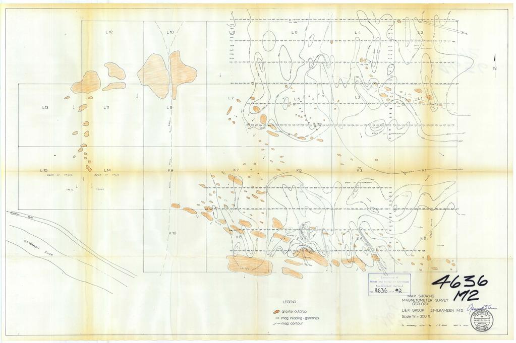
2 1. SUMMARY Fury Explorations Ltd. (N.P.L.) carried out a Preliminary Magnet- ometer Survey and Reconnaissance Geological mapping over the L and K Group of Claims from April 1, 1973 until June 22, Control for this workms marking, picketing and chaining lines in both north-south and e as t-we st directions, PROPERTY The L and K Group of Claims, consisting of the L 1 to L 15 and K 1 to K 10 are located 8 miles east of Princeton, British Columbia in the Similkameen Mining Division at 49' 27' N, 120' 16' W. The claims are owned by Fury Explorations Ltd. (N.P.L.) Name of Claim L 1 to L 15 Incl. K 1 to K 10 Incl. and are recorded; Record Numbers Incl Incl. GENERAL GEOLOGY The geology of the area is outlined on Map 888-A, Princeton Sheet, scale 1**= 4 mi. prepared by the Geological Survey of Canada. The area surrounding the claims is underlain by rocks of the Coast Range Intrusion.
3 f- TABLE OF CONTENTS SUMMARY... PROPERTY... GENERAL GEOLOGY... HISTORY OF PROPERTY... PRESENT PROGRAM... LINE CUTTING... MAGNETOMETER SURVEY... RECONNAISSANCE GEOLOGIC& MAPPING... STATEMENT OF COSTS... PERSONNEL... a ! i
4 2. HJSTORY OF PROPERTY Old claim posts indicate that parts of the property were previously staked, on at least two occasions, although there is no record of prev-. ious work having been filed and there is no physical evidence of previous work. PRESENT PROGRAM The work program carried out by Fury Explorations Ltd. (N.P.L.) consisted of line cutting, chaining and picketing, preliminary magnet- ometer surveying and preliminary geological mapping. The geological mapping was carried out by James R. Glass, P. Eng. and by three field assistants, who did the line cutting and performed the magnetometer survey. A Map of scale 1" = 300' showing the magnetometer survey results and the general geology is included with this Report. LINE CUTTING Eleven east-west lines were cut, marked and picketed at 100 foot intervals. One north-south line was cut and marked as a tie-in base line.
5 r- MAGNETOMETER SURVEY A Magnetometer survey was carried out using the prepared picket lines for control. The readings were taken with a Jalander Magnetometer, Model W 505, Type No. 46 = 65, at 100 foot intervals along the lines. Notes were taken on.topographic features as well as general outcrop patterns. The readings were tied into a base station and diurnal variations calculated. A Map of scale 1" = 300' showing the readings taken and the contoured results has been prepared and is included with this Report. The results of the magnetic survey show no significant rock changes or major structural trends on the property. There is some magnetic relief in the southern portion of the Claim Group which is located in an area of cliffs and rock outcroppings. The magnetic relief is interpreted.f- as a combination of minor faulting and topographic expression. RECONNAISSANCE GEOLOGICAL MAPPING The writer spent two and one-half days performing preliminary geological $" B 9 4 mapping and plotting the general outcroppings pattern. The property is underlain by massive to slightly fractured quartz diorite which is cut byl a set of fractures striking approximately N 30' E and dipping from 45' to 75' N.W. * Minor dykes, both acitic and basic, intrude the granite. There is minor alteration consisting of epidotization and silicification. A Map of scale 1" = 300' showing the outcroppings pattern is included with this Report.
6 4. STATEMENT OF COSTS Line cutting and Magnetometer Survey ll-miles 8 $-190-;00 per mile Geological mapping 24 days 8 $50.00 per day Hotel and expenses Vehicle - 2 days 8 $35.00 per day $ 2, $ 2, PERSONNEL : James R. Glass, P. Eng. April 1, June 20, June 21, 1973 John Powney, Penticton, B.C. June 17 to June 20, 1973 C. S. Powney, Penticton,B.C. June 17, 1973 Fred Lolus, Penticton, B.C. June 18 to..'june 20,
7
8
I 4.w.g //old. Lat. 5Oo35T Long T. for. By: James R. Glass, P. Eng. June 6, DUSTY MAC MINES LTD. (N.P.L.)
") 440 6 REPORT ON MAGNETOMETER SURVEY POD GROU'OF CLAIMS HIGHLAND VALLEY KAMLOOPS MINING DIVISION Lat. 5Oo35T Long. 120 55T 9.2 1 //old for DUSTY MAC MINES LTD. (N.P.L.) By: James R. Glass, P. Eng. June
440 6 REPORT ON MAGNETOMETER SURVEY POD GROU'OF CLAIMS HIGHLAND VALLEY KAMLOOPS MINING DIVISION Lat. 5Oo35T Long. 120 55T 9.2 1 //old for DUSTY MAC MINES LTD. (N.P.L.) By: James R. Glass, P. Eng. June
7 MILES WEST OF PORT HARDY, B.C.
 GEOPHYSICAL REPORT VERTICAL INTENSITY MAGNETOMEER SURVEY ON LUK CLAIMS, 7 MILES WEST OF PORT HARDY, B.C. 50' 127O SE BY R. E. SHIELDS UNDER SUPERVISION OF J. R. BILLINGSLEY FOR SECOND0 MINING LTD. (N.
Canadian National Railways tracks from the foot bridge across the. Thompson River from the Trans Canada Highway. A pick-up truck was used
 Canadian National Railways tracks from the foot bridge across the Thompson River from the Trans Canada Highway. A pick-up truck was used on the highway side and a h-wheel drive Jeep was transported by
41,a* h0.iiii*bll*i2l,i DEADWOOD CREEK. for. James R. on the BOMBINI GROUP OF CLAIMS. GREENWOOD, British Columbia. Lat. 49'07' Long. 118'43 f.
 GEOLOGCAL REPORT on the BOMBN GROUP OF CLAMS DEADWOOD CREEK GREENWOOD, British Columbia Lat. 49'07' Long. 118'43 f in the GREENWOOD MNNG DVSON for FURY EXPLORATONS LTD. (N. P. L. ) Vancouver, B. C. December
BALFOUR MINING LTD. (N.P.L.) HAM GROUP 92-P-6, CLINTON M. D.8 B. C. Lat 51 17'N, GEOCHEMICAL REPORT. V. CUKOR, P. Eng.
 HAM GROUP 92-P-6, CLINTON M. D.8 B. C. Lat 51 17'N, GEOCHEMICAL REPORT. V. CUKOR, P. Eng.") 34q '7 BALFOUR MINING LTD. (N.P.L.) HAM GROUP 92-P-6, CLINTON M. D.8 B. C. Lat 51 17'N, Long 12lo14'W GEOCHEMICAL REPORT, V. CUKOR, P. Eng. January 31, 1972 TABLE OF CONTENTS 1. INTRODUCTION 2. PROPERTY,
34q '7 BALFOUR MINING LTD. (N.P.L.) HAM GROUP 92-P-6, CLINTON M. D.8 B. C. Lat 51 17'N, Long 12lo14'W GEOCHEMICAL REPORT, V. CUKOR, P. Eng. January 31, 1972 TABLE OF CONTENTS 1. INTRODUCTION 2. PROPERTY,
3 I1 I I Ill 111 II! II 111 II Ill I IlE I I P I
 -7 3 1 1 11111111111111111111111111111111 ll 111! 111 111 111 111 111111111111111 ll 1111111 1 11111111111111 le P GEOCHEMCAL SURVEY OF THE KE AND D'ARCY CLAM GROUPS.. Similkameen Mining Division, B.C.
GEOCHEMICAL REPORT ON A SOIL SAMPLING SURVEY OF PORTIONS OF THE KR GROUP OF MINERAL CLAIMS OF PLATEAU METALS LIMITED.
 GEOCHEMICAL REPORT ON A SOIL SAMPLING SURVEY OF PORTIONS OF THE KR GROUP OF MINERAL CLAIMS OF PLATEAU METALS LIMITED By Kol Lovang Christopher Riley, P. Eng., Supervisor c Vancouver, B. c. Work Performed:
Introducti on. Land Survey. Geomagnetic Survey. Geomagnetic Results and Interpretati ons - Conclusions and Recommendations C
 m M 42A86SW8281 63.42 PRICE 010 C O H T E H l 42A86SW828I 63.42 PRICE 010C Introducti on Land Survey Geomagnetic Survey Geomagnetic Results and Interpretati ons - Conclusions and Recommendations - - -
GEOPHYSICAL REPORT. Airborne Magnetometer Survey. of the SHEEP-GOAT GROUP OF MINERAL CLAIMS. near Li l looet, B.C.
 GEOPHYSICAL REPORT 977 Airborne Magnetometer Survey of the SHEEP-GOAT GROUP OF MINERAL CLAIMS near Li l looet, B.C. Lillooet Mining Division (Lat.51 'lot Long. 122 40' 7 5t0[2L05E. for DUFFEY LAKES MINES
 ..m,"f.k*"--v- A tot,al of 18 line miles of magnetometer surveying was completed on the "B" and "J" claim groups during August of 197. Approximately two-thirds of the area covered by the survey is glaciated,
PROSPECTORS ASSISTANCE PROGRAM MINISTRY OF ENERGY AND MINES
 BRITISH COLUMBIA PROSPECTORS ASSISTANCE PROGRAM MINISTRY OF ENERGY AND MINES GEOLOGICAL SURVEY BRANCH PROGRAM YEAR: 1999/2000 REPORT #: PAP 99-l 6 NAME: KIM ANSCHETZ PROSPECTORS TlEPORT on the 99 LOUIS
'-7' REPORT ON A MAGNETOMETER SURVEY OVER PART OF THE MAX CLAIM GROUP 1-20 LAC LE JEUNE AREA KAMLOOPS MINING DIVISION KAMLOOPS, BRITISH COLUMBIA
 I,., - SUITE 102. 222 BELLEVUE WES t ANCOUVER, B. '-7' REPORT ON A I MAGNETOMETER SURVEY OVER PART OF THE MAX CLAIM GROUP 1-20 LAC LE JEUNE AREA KAMLOOPS MINING DIVISION KAMLOOPS, BRITISH COLUMBIA 50-30
Compilation Report Hawke Hill South. Licence No M NTS 01N/06. Newfoundland and Labrador. Submitted by Gordon E. Cooper and Kevin P.
 Compilation Report 2010 Hawke Hill South Licence No. 017282M NTS 01N/06 Newfoundland and Labrador Submitted by Gordon E. Cooper and Kevin P. Ryan For Kevin P. Ryan (Licence holder) January, 2011 Work Year:
2013 GEOLOGICAL ASSESSMENT REPORT SHERIDAN HILL PROPERTY
 2013 GEOLOGICAL ASSESSMENT REPORT ON THE SHERIDAN HILL PROPERTY NEW WESTMINSTER MINING DIVISION BRITISH COLUMBIA NTS 092G07 49 16 31 NORTH LATITUDE, 122 39 48 WEST LONGITUDE PREPARED FOR Sheridan Hill
GEOLOGICAL BRANCH ASSESSMENT REPORT
 GEOLOGICAL BRANCH ASSESSMENT REPORT REPORT ON GEOPHYSICAL GROUND SURVEYS ON THE CHILI CLAIM MAGNETIC, VLF DIP ANGLE ELECTROMAGNETIC, AND VLF RESISTIVITY SURVEYS BY HI LIMION SEPTEMBER 12, 1986 &! FILMED
REPORT ON MAGNETOMETER SURVEY TIK-1 CLAIM e&f KAMLOOPS MINING DTVISION. by D. Hendry D. C. MILLER. February 3, for
 REPORT ON MAGNETOMETER SURVEY TIK-1 CLAIM 92-1-14 e&f KAMLOOPS MINING DTVISION lat. 50 57 ' 12" long. 121O23 ' 37" OWNER: ST. JOSEPH EXPLORATIONS LIMITED OPERATIOR: ST. JOSEPH EXPLORATIONS LIMITED by D.
The survey covered claims, in part or in full, DUCKLING 3, 4, 5, 4 fraction, and 5 fraction.
 514 687-6671 XXX- 602 West Hastin~a StroeP, Vata;sn@ouver, BritlsA fhlum~b~a, Garaadsa B81apphgtaa DISCUSS ION OF MAGNETOMETER SURVEY ON DUCKLING CLAIMS FOR DONNA MINES LTD. (N0P.L.) Submitted to: DONNA
REPORT. on the. Omineca Mining Division, British Columbia. Latitude N., Longitude W. NTS map sheet 93F/7E. James W. McLeod, P.Geo.
 REPORT on the CHU MOLYBDENUM PROPERTY Omineca Mining Division, British Columbia Latitude 53 21 N., Longitude 124 37 W. NTS map sheet 93F/7E James W. McLeod, P.Geo. on behalf of Mr. Chris Delorme TABLE
GEOPHYSICAL REPORT THE CAVZ CLAIMS
 GEOPHYSICAL REPORT Magnetometer Survey on THE CAVZ CLAIMS CAVZ M.C.'s 1 to 12, 15 to 26, 29 to 40, 45 to 54 Trail Peak, Omineca M.D. 13 miles northeast of Fort Babine 550 ) 126 S.E. by G.Podolsky J.Russell
on the SALAL CREEK MOLYBDENUM PROPERTY, SALAL CREEK, B.C. LILLOOET MINING DIVISION, BRITISH COLUMBIA
 on the J PLUG 9-12, PLUG 19-24, BAT 10-14, BAT 15 Fr., BAT 16 Fr. MINERAL CLAIMS, SALAL CREEK MOLYBDENUM PROPERTY, SALAL CREEK, B.C. LILLOOET MINING DIVISION, BRITISH COLUMBIA N.T.S. 92 J 14 LATITUDE 50
Rail Lake Copper Property (WB Claims) G.M. Depaoli, B.Sc. Geophysicist J.F. ALl.an, P.Eng. (B.C.! July 1973
 G.M. Depaoli, B.Sc. Geophysicist J.F. ALl.an, P.Eng. (B.C.! July 1973") 1973 Geophysical Report TITLE AUTHORS DATE, COI"4ODITY LOCATION-A rea -Mining Division -Coordinates -NTS Rail Lake Copper Property (WB Claims) GM Depaoli, BSc Geophysicist JF ALlan, PEng (BC! July 1973
1973 Geophysical Report TITLE AUTHORS DATE, COI"4ODITY LOCATION-A rea -Mining Division -Coordinates -NTS Rail Lake Copper Property (WB Claims) GM Depaoli, BSc Geophysicist JF ALlan, PEng (BC! July 1973
490 20' 30" North Latitude ' 30" West Longitude
 _._.. I CONSULTING GEOLOGISTS 605-602 WEST HASTINGS STREET, VANCOUVER, B.C. V6B 1P2 TELEPHONE: (604) 689-5533 6 I F: ASSESSMENT REPORT ON THE PATSY 1 MINERAL CLAIM ' '?%2% I WHISTLE CREEK, HEDLEY ARE L-l-
A Prospecting Report on the Leo d Or Mineral Claims
 A Prospecting Report on the Leo d Or Mineral Claims Hnvilah Gold Mines Ltd. John Devlin Ande Rychter Leo d Or Claims 2202 C63 NTS, 32 L/7NNippkish 1264 W W, 508) 23$J o f Owner: M.S. Madnri /nay 25, 1987
J.D. Mason, Prof. Engineer. Report on the Reconnaissance Magnetometer Survey. Completed for. North American Platinum Corporation Ltd.
 Report on the Reconnaissance Magnetometer Survey Completed for North American Platinum Corporation Ltd. Olivine Mountain Property, Tulameen, B.C. J.D. Mason, Prof. Engineer. November 28, 1967. Certificate
Prospecting Report 'S Office i DB Property, B.C. -J Negro Creek Nelson Mining District NTS 82F.050. Operator: Kootenay Gold Inc.
 . '.' I"' i9 12 Prospecting Report 'S Office i DB Property, B.C. -J Negro Creek Nelson Mining District NTS 82F.050 Operator: Kootenay Gold Inc. Owner: Darlene Lavoie Work Performed Summer of 2007 Report
PROSPECTING REPORT THE WALLACE CLAIM OMENICA MINING DIVISION. 54" x6" 3.d d. for. Reako Exlorat ions Ltd. Wallace Rev. C.G.
 PROSPECTING REPORT ON THE WALLACE CLAIM OMENICA MINING DIVISION 54"44 14 1x6" 3.d d by David A. Howard P.Eng. for Reako Exlorat ions Ltd. Claim Locat ion Wallace Rev. C.G. #1560 Dome Mountain Area 9 3
W. 1.NELSON Jr. P. ENG.
 GEOCHEMICAL AND GEOPHYSICAL SURVEY SNO GROUP CLAIMS W. 1.NELSON Jr. P. ENG. NORANDA EXPLORATION COMPANY, LIMITED OMINECA MINING DIVISION AUG. 17, 1971 - AUG. 29, 1971 TABLE OF CONTENTS - Page INTRODUCTION
GRISWOLD CREEK, B.C. 6 " GEOCHJ3lICAL REPORT
 GRISWOLD CREEK, B.C. 6 " GEOCHJ3lICAL REPORT AUTROR: W. Meyer, BSc. ENDORSED El!: John De Leen, BASc.* NASc., E.M., P. Eng. No. 3675 Vancouver, B.C. January 22nd, 1965. -I- During the period of July 27th
TOPOGRAPHICAL SURVEY REPORT ON THE GREENDROP PROPERTY NEAR CHILLIWACK, B.C. 92-H-3/W
 TOPOGRAPHICAL SURVEY REPORT ON THE GREENDROP PROPERTY NEW WESTMINSTER M.D. NEAR CHILLIWACK, B.C. 92-H-3/W Location: The central pap of the claims is located at coordinates 49 08'N, latitude by 121 26'W,
MODERN GEOPHYt INTRODUCTION
 MODERN GEOPHYt SUITE 5-13 ADELAIDE ST. E. TORONTO - ONTARIO 42A06SE8121 63.1009 ELDORADO 0 10 JU*Jkl.TJLA. JL JL^A^r GEOPHYSICAL SURVEYS ELECTROMAGNETIC (VERTICAL 8r HORIZONTAL) TELEPHONE: MAGNETIC EMPIRE
Summary of Rover Metals Geologic Mapping Program at the Up Town Gold Project, Northwest Territories
 October 13, 2017 Summary of Rover Metals Geologic Mapping Program at the Up Town Gold Project, Northwest Territories Vancouver, British Columbia, Canada - Rover Metals Corp., Rover, is pleased to provide
We are committed to providing accessible customer service. If you need accessible formats or communications supports, please contact us.
 We are committed to providing accessible customer service. If you need accessible formats or communications supports, please contact us. Nous tenons à améliorer l accessibilité des services à la clientèle.
GEOLOGICAL BRANCH ASSESSMENT REPORT 12. FItE NO: ACTION: THE GOLDEN MINING DIVISION, GOLDEN, Including THE NTS MAP; M82K/15W
 ACTION: FItE NO: Including 1990 GEO-CHEM SURVEY RESULTS -- THE AVD CLAIMS - THE GOLDEN MINING DIVISION, GOLDEN, B.C. NTS MAP; M82K/15W Lat. 50 deg. 55 Min. Long 116 deg. 55 min. For GEOLOGICAL BRANCH ASSESSMENT
GIANT MASCOT MINES LIMITED ~nen~z~s~11~uumsn~ SURRARD STREET VANCOUVER 1, B. C. June 4, 1968
 NtNI OFFICE; P. 0. BOX 820. HOPE. 8. C. TELEP*ON
NICOLA M.D King Street West, April, 1969 AMALG 1-44 MINERAL CLAIMS 1. OWNER: Dr. F. R. Burton, W. M. Sirola, P. Eng.
 REPORT ON ' MAGNETIC AND ELECTROMAGNETIC SURVEY AMALG 1-44 MINERAL CLAIMS 1. NICOLA M.D. 49'501 N - 12Oo57f W OWNER: Dr. F. R. Burton, 1506-44 King Street West, Toronto 1, Ontario. by W. M. Sirola, P.
compietea since tnat date, and wnicn comprisea btage I ot tne recommended
 compietea since tnat date, and wnicn comprisea btage I ot tne recommended four-stage program. GEOLOGY & MINERALIZATION The property situate6 on the southeast slope of Nickel Plate Mtn., and within the
FIRST YEAR ASSESSMENT REPORT PROSPECTING LICENCE 16512M MARYSTOWN AREA, BURIN PENINSULA NTS 1M/3
 FIRST YEAR ASSESSMENT REPORT OF PROSPECTING ON LICENCE 16512M MARYSTOWN AREA, BURIN PENINSULA NTS 1M/3 BY NATHANIEL NOEL MSc. FOR E. MICHELE NOEL MINERAL LICENCES: 16512 M WORK CONDUCTED: MID-SEPTEMBER
ASSES5dMENT REPORT. Department of. Sept. 15th, Mines and Petroleum Resource.: NO... s?.rk... MAP... I. GEOPHYSICAL mport
 GEOPHYSCAL mport ON THE 92~/2 FOSSELL CmEK GROUP OF COUS CmEK COPPER MNES LTD. AT PORT ALBERN, B. C. BY N.B. VOLLO, P.ENG Sept. 15th, 1976 t Department of Mines and Petroleum Resource.: ASSES5dMENT REPORT
Assessment Work Report. on the Geophysical Surveys carried out over the
 Assessment Work Report on the Geophysical Surveys carried out over the PINE GROUP of Mineral Claims 951-J-15-W Lillooet Mining Division Goldbridge, B.C. Long 122 48' Lat. 50 48' by Levon Resources Ltd.
GEOLOGICAL REPORT and MAGNETOMETER SURVEY 1-34 December 1 to.3, 1973 SIMILKAMEEN MINING DIVISION 'W, 49O 36'N.
 4 03' GEOLOGICAL REPORT and MAGNETOMETER SURVEY on @CLAIMS 1-34 December 1 to.3, 1973 SIMILKAMEEN MINING DIVISION 120 21'W, 49O 36'N w f Cepartmcnt of Mines 22.2 Pe>rsi-.um Resources I.., A43~J~lr,~r.'F
A PRELIMINARY REPORT ON THE ZYMOST2 CLAIM GROtP, TERRACE, B.C.
 NATIVE EXPLORATIONS LTD. A PRELIMINARY REPORT ON THE ZYMOST2 CLAIM GROtP, TERRACE, B.C. INTRODUCTION': The Zymoetz claim group is, at present, held under option by Native Explorations Ltd.. On the 19th
SUPPLEMENT TO MAGNETOMETER 6 ELECTROMAGNETIC SURVEY REPORT. DATED NOVEMBER l, 1973 CIGLEN INVESTMENTS LIMITED CLAIMS GROUP BAD VERMILLION LAKE AREA
 ^ A R l ^ 1974 010 PROJECTS UNIT SUPPLEMENT TO MAGNETOMETER 6 ELECTROMAGNETIC SURVEY REPORT DATED NOVEMBER l, 1973 CIGLEN INVESTMENTS LIMITED CLAIMS GROUP BAD VERMILLION LAKE AREA DISTRICT OF RAINY RIVER
REPORT ON GEOPHYSICAL SURVEYS ON THE BAMAJI LAKE PROPERTY CROBIE PROJECT, NW ONTARIO OF UMEX INC.
 S20e3NWe«28 S20«3NWee37 FRY LAKE 0 1 0 REPORT ON GEOPHYSICAL SURVEYS ON THE BAMAJI LAKE PROPERTY CROBIE PROJECT, NW ONTARIO OF UMEX INC. Patricia Mining Division NTS 52 0/3 Latitude 51 10'N Longitude 91
ASSESSMENT REPORT MAGNETOMETER SURVEY GOLDEN ROD, GOLDEN ROD #2. Long.: General Delivery, Vananda, B. C.
 ASSESSMENT REPORT MAGNETOMETER SURVEY GOLDEN ROD, GOLDEN ROD #2 t=/ NTS 92~110w Lat.: Long.: 49O 44' N 124O 34' W Owner: E. Johanson General Delivery, Vananda, B. C. Operator: Rhyolite Resources I nc.
1 CLAIMS GEOPHYSICAL REPORT ON BOYAL SITUATE NORTHEAST OF TILLICUM MOUNTAIN GOLD AREA BURTON - NAKUSP SIQCAEJ MINING DIVISION
 GEOPHYSICAL REPORT ON BOYAL 1 CLAIMS SITUATE NORTHEAST OF TILLICUM MOUNTAIN GOLD AREA BURTON - NAKUSP SIQCAEJ MINING DIVISION CONSULTING GEOLOGIST AUGUST 1983 VANCOUVER B *C INDEX INTRODUCTION ooa,.eoaaa.aaaoaaooaoa~ao~o
NTS 93L/9W GEOCHEMICAL AND GEOPHYSICAL REPORT MONA CLAIM OMINICA MINING DIVISION. Lati tude 54036'N; Longitude 'W
 GEOCHEMICAL AND GEOPHYSICAL REPORT ON MONA CLAIM OMINICA MINING DIVISION Lati tude 54036'N; Longitude 126018'W NTS 93L/9W April 1981 Paul Plicka Consulting Geologist LOCATION MAP INTRODUCTION TABLE OF
GEOLOGICAL AND GROUND MAGNETOMETER SURVEYS. on the K.M. B.W., AND ROCK CLAIMS KAMWOPS MINING DIVISION. on behalf of
 GEOLOGICAL AND GROUND MAGNETOMETER SURVEYS on the K.M. B.W., AND ROCK CLAIMS KAMWOPS MINING DIVISION on behalf of ROCKET MINES LTD. (N.P.L.) P. P. Nielsen, B. Sc., Geophysicist and G. C. Gutrath. P. Eng.,
UNION MINIERE EXPLORATIONS AND MINING CORPORATION LIMITED ASSESSMENT REPORT ON FITINAT MINERAL CLAIM. Alberni Mining Division Record No.
 M F )( UNION MINIERE EXPLORATIONS AND MINING CORPORATION LIMITED Suite 200, 4299 Canada Way, Burnaby, B.C. V5G 1 H4 Telephone (604) 437-9491 ASSESSMENT REPORT ON GEOCHEMICAL SOIL SURVEYS AND ROCKSAMPLING
NEW HAZELTON, OMINECA M.D.,
 PROSPECTING REPORT JUDI 1 TO 6 MINERAL CLAIMS NEW HAZELTON, OMINECA M.D., B.C. MAP 93M/4E, LAT. SS014'N, LONG. 127'33'W OWNED BY: A. L'ORSA ANTHONY L'ORSA Smithers, B.C. 21 February, 1981 TABLE OF CONTENTS
..!I AXE CLAIMS ON THE. for RICHCORE EXPLORATIONS LTO. GREENWOOD MINING DIVISION BRITISH COLUMBIA. Latitude 49O 30"; Longitude 118' 30'W NTS 82E/9W
 ON THE AXE CLAIMS for RICHCORE EXPLORATIONS LTO. GREENWOOD MINING DIVISION BRITISH COLUMBIA Latitude 49O 30"; Longitude 118' 30'W NTS 82E/9W... -... ~ i.,...._.'..!i Vancouver, B.C. September, 1980 P.
1 FILMED 1. FILE NO:!..rsrru -* -. GRAND TWO CLAIM
 FILE NO:!..rsrru -* -. GRAND TWO CLAIM REPORT ON 1993 ASSESSMENT WORK GRAND TWO CLAIM REC. NO. 301849 NELSON MINING DIVISION NTS MAP SHEET 82F6/W 49 25'51" NORTH 117 18'08" WEST 1 FILMED 1 AUTHOR: R. Jordan,
SELF POTENTIAL SURVEY OVER THE JAY GROUP, INVERMERE AREA GOLDEN MINING DIVISION, BFUTISH COLUMBIA NTS 82W8W7 82W9W LATLONG 50 30' ' FOR
 - GEOLOGICAL SURVEY BRANCH ASSESSMENT REPORTS -- -- DATE RECEI?/::D 06T 10 1996 - SELF POTENTIAL SURVEY OVER THE JAY GROUP, INVERMERE AREA GOLDEN MINING DIVISION, BFUTISH COLUMBIA NTS 82W8W7 82W9W LATLONG
Geomagnetic. Guibord Township Group #2, Bast Part Hollineer Consolidated Gold Mints. Ltd
 42Aa9SEe267 63.19,9 GUIBORD """"" 11 Geomagnetic Guibord Township Group #2, Bast Part Hollineer Consolidated Gold Mints. Ltd 010 Introduction During the period March 31 t 1965 to Jan. 10, 1966 a magnetometer
BGND 2-7 CLAIMS, KELOWNA, B.C.
 GEOLOGICAL EVALUATION of BGND 2-7 CLAIMS, KELOWNA, B.C. 5"'33"N; 9"33'3"W:NTS 82L/4E BEAR CREEK: 4Km NNW of Kelowna Vernon Mining Div., British Columbia by N. C., P.Geol., P. Eng. Consulting Geologist,
for the Greenwood Mining Division, B.C. NTS 82E/7W 29' W, Longitude 118' 53' N Prepared by D. Dylan Watt, B.Sc.
 for the FltE NO: u VOLT 1, VOLT 2, VOLT 3, & VOLT 4 CLAIMS Greenwood Mining Division, B.C. NTS 82E/7W Latitude 49' 29' W, Longitude 118' 53' N Prepared by D. Dylan Watt, B.Sc. #309-1996 Trutch Street Vancouver,
RECONNAISSANCE GEOCHEMICAL SURVEY
 RECONNAISSANCE GEOCHEMICAL SURVEY LEGAL, RITA, LOUISE FR. (CHAPLEAU GROUP) REVERTED CROWN GRANTS CHAPLEAU CREEK AREAJ, SLOC& MINING DIVISION 82 F/11W Lat: 49'44" Long: 117"22'W MINERAL RESOURCES BRANCH
NO. MAP..._._..._...,,..,.
 KERR- ADDISON GOLD MINES LIMITED SELF-POTENTIAL SURVEY OWL!i- 12 1 Dwner ) NAOINA 1-4 ) MINERAL CLAIMS W. F. McGowan, ) 3262 Marine Orive, ANGUS 1-4 ) west Vancouver, 8. c. LOCATED AT 5. E. ENO OF OWEN
GEOPHYSICAL REPORT ON A VLF-EM SURVEY OVER THE BOSS 1 AND 2 CLAIMS HEDLEY AREA SIMILKAMEEN MINING DIVISION BRITISH COLUMBIA
 GEOPHYSICAL REPORT i ON A VLF-EM SURVEY OVER THE BOSS 1 AND 2 CLAIMS HEDLEY AREA SIMILKAMEEN MINING DIVISION BRITISH COLUMBIA PROPERTY SURVEYED BY : 11.0 h S60W of Bedley : 49' 120O SE : N.T.S. 92~18~
A Report on a Magnetometer Survey. Division, British Columbia. Gypsy 1-32 and Gypsy 1 Fr-9 Fr. 27 miles north of Smithers
 - A Report on a Magnetometer Survey on the Gypsy Claims, Omineca Mining Division, British Columbia Covering: Gypsy 1-32 and Gypsy 1 Fr-9 Fr Located: 27 miles north of Smithers Latitude 55O11' N Longitude
42H88SW NEWMAN
 42H88SW0003 63.8199 NEWMAN 010 TRIPOINT MINES LIMITED, Suite 305-100 Adelaide St. West, Toronto l, Ontario. Gentlemen: Your Company recently conducted a combined magneticelectromagnetic survey over a ten
for the Greenwood Mining Division, B.C. NTS 82E/7W Latitude 49' 27' W, Longitude 118' 5 Prepared by a= D. Dylan Watt, B.Sc.
 t. b LOGnO: 37~ -08 m. ACTIO#: for the AMP AMP 2 AMP 3 t AMP 4 CLAIMS Greenwood Mining Division, B.C. NTS 82E/7W Latitude 49' 27' W, Longitude 8' 5 %E c,w zc *& a w Prepared by a= -4c. D. Dylan Watt, B.Sc.
ASSESSMENT REPORT PROSPECTING PROGRAM ION/DIRTY JACK PROPERTY NELSON MINING DIVISION N.T.S. MAP SHEET 82F.023 UTM COORDINATES N E
 ASSESSMENT REPORT PROSPECTING PROGRAM ION/DIRTY JACK PROPERTY NELSON MINING DIVISION N.T.S. MAP SHEET 82F.023 UTM COORDINATES 5454800N - 0455235E Work Performed Summer 2007 OWNER >* ' Tom Kennedy >8 404-22
REPORT ON GEOLOGY DUVAN COPPER COMPANY LTD. REX LAKE PROPERTY, TORONTO.
 * 52L*7NEM36 7 63A.S55 REX LAKE 010 REPORT ON GEOLOGY DUVAN COPPER COMPANY LTD. REX LAKE PROPERTY, TORONTO. Toronto, Ontario July 28, 19^9- INTRODUCTION A party consisting of A. Kopare, engineer and P.
VLF and GRADIOMETER SURVEY OVER THE CAT GROUP, INVERMERE AREA GOLDEN MINING DIVISION, BRITISH COLUMBIA NTS 82K/O8W LAT/LONG 50 29' ' FOR
 VLF and GRADIOMETER SURVEY OVER THE CAT GROUP, INVERMERE AREA GOLDEN MINING DIVISION, BRITISH COLUMBIA NTS 82K/O8W LAT/LONG 50 29' - 116 15' FOR W. POCHYLKO STETTLER, ALBERTA BY T.R.B. DUNDAS ISOGEOS EXPLORATION
We are committed to providing accessible customer service. If you need accessible formats or communications supports, please contact us.
 We are committed to providing accessible customer service. If you need accessible formats or communications supports, please contact us. Nous tenons à améliorer l accessibilité des services à la clientèle.
REPORT ON THE MAGNETOMETER SURVEYOF THE SO0 MINERAL CLAIMS MERRITT, B. C.
 336 REPORT ON THE MAGNETOMETER SURVEYOF THE SO0 MINERAL CLAIMS MERRITT, B. C. To: The Directore Copper Soo Mining Syndicate OSO~OOS, B. C. R. C. Clough hglneering Ltd. Harvey H. Cohen, P. Pmg. TABLE OF
ASSESSMENT' REPORT GEOPHYSICAL REPORT ON THE ATTORNEY 2 CLAIM (4 UNITS) OMINECA MINING DIVISION SHEILA A. CRAWFORD.
 OMINECA MINING DIVISION SHEILA A. CRAWFORD.") ASSESSMENT' REPORT GEOPHYSICAL REPORT ON THE ATTORNEY 2 CLAIM (4 UNITS) OMINECA MINING DIVISION by SHEILA A. CRAWFORD LOCATION: 57z17' N Latitude 127 11' W Longitude N.T.S. 94E/6E OWNER/OPERATOR: SEREM
ASSESSMENT' REPORT GEOPHYSICAL REPORT ON THE ATTORNEY 2 CLAIM (4 UNITS) OMINECA MINING DIVISION by SHEILA A. CRAWFORD LOCATION: 57z17' N Latitude 127 11' W Longitude N.T.S. 94E/6E OWNER/OPERATOR: SEREM
GEOCHEMICAL REPORT LAST LINK GROUP TEXADA ISLAND NANAIMO MINING DIVISION
 I GEOCHEMICAL REPORT LAST LINK GROUP TEXADA ISLAND NANAIMO MINING DIVISION -1- PROSPECTING & GEOCHEMICAL SOIL SURVEY FOR GOLD On the Last Link Group of Claims North End of Texada Island Nanaimo Mining
The SL group is located 10 miles east of Lac La Hache and can be reached by good secondary roads.
 0 Summary Soil samples were collected and analyzed for trace mercury vapour content over a magnetic and electromagnetic anomaly. Weak positive evidence of base metal mineralization was obtained. Location
GEOPHYSICAL ASSESSMENT REPORT (TOP & BOTTOM CLAIMS) MCINTYRE LAKE. VERNON MINING DIVISION, B-Cm
 MCINTYRE LAKE. VERNON MINING DIVISION, B-Cm") GEOPHYSICAL ASSESSMENT REPORT on the TOP PROPERTY (TOP & BOTTOM CLAIMS) MCINTYRE LAKE VERNON MINING DIVISION, B-Cm NTS : Latitude: 50'04' North Longitude: Owner: Consultant : Author : 118'33 ' West Brican
GEOPHYSICAL ASSESSMENT REPORT on the TOP PROPERTY (TOP & BOTTOM CLAIMS) MCINTYRE LAKE VERNON MINING DIVISION, B-Cm NTS : Latitude: 50'04' North Longitude: Owner: Consultant : Author : 118'33 ' West Brican
MONETA PORCUPINE MINES, LIMITED
 MONETA PORCUPINE MINES, LIMITED VANCOUVER 3. B.C. Telephone: MIJtd 1.9721 The Mining Recorder, GRAND FORKS, B.C. Dear Sir:- The following is a record of salaries, wages, and expenses paid in connection
Lat. 52' 43' N Long ' W
 &A exploration ltd MINING ENGINEERING GEOLOGY- GEOPHYSICS 4570 HOSKINS ROAD, NORTH VANCOUVER, 6. C. TELEPHONE (804) 985,7921 V7K 2R1 GEOLOGICAL AND GEOCHEMICAL REPORT on the BLUE CLAIMS Cariboo Mining
lat ' N Long ' W
 305 7 ec1;, REPORT ON THE JERY CLAIMS OF POLA RESOURCES LTD. NTS 93L/16 0 0 lat. 54 45' N Long. 126 22' W BABIXE LAKE AREA OMINECA MINING DIVISION, B.C. PAUL PLICKA CONSULTING GEOLOGIST DECEMBER 30, 1981
PRECIOUS METALS. owner. JMT Services Corp. GEOCHPlICAL SAMPLING CHELASLIE WCE, NORTH CENTRAL, B.C. OMINECA MINING DIVISION NTS 93F/5E & 6W
 PRECIOUS METALS REPORT ON 1980 RECONNAISSANCE GEOCHPlICAL SAMPLING CHELASLIE WCE, NORTH CENTRAL, B.C. OMINECA MINING DIVISION NTS 93F/5E & 6W LATITUDE 53O28 N LONGITUDE 125O31 W DATES Qp WORK: JULY 10
OEOMAQNETIC SURVEI QUIBORD TOWNSHIP GROUP #2 HOLLINGER CONSOLIDATED GOLD MINES, LTD.
 OEOMAQNETIC SURVEI QUIBORD TOWNSHIP GROUP #2 HOLLINGER CONSOLIDATED GOLD MINES, LTD. 42Ae9SE0268 63.1502 GUIBORD (711(71 Introduction During the period January 5 - February 26, 1965, a magnetometer survey
GEOLOGICAL MAPPING REPORT ON THE ASH MINERAL CLAIM OSOYOOS MINING DIVISION ASHNOLA RIVER MAP SHEET NTS M092,H019 MCBRIDE CREEK AREA, ASHNOLA RIVER,
 GEOLOGICAL MAPPING REPORT ON THE ASH MINERAL CLAIM OSOYOOS MINING DIVISION ASHNOLA RIVER MAP SHEET NTS M092,H019 LATITUDE 49 o O6, LONGITUDE 120 o 22 MCBRIDE CREEK AREA, ASHNOLA RIVER, KEREMEOS, B.C. CANADA
Amboy Iron Mines, Bristol Mountains, San Bernardino County, California. Gregg Wilkerson 2017
 Amboy Iron Mines, Bristol Mountains, San Bernardino County, California Gregg Wilkerson 2017 Acknowledgement and Disclaimer The information in this paper is taken largely from published sources. I have
KEMESS SOUTH MAGNETIC MODELING. CONDOR CONSULTING, INC. OCTOBER 2017
 KEMESS SOUTH MAGNETIC MODELING. CONDOR CONSULTING, INC. OCTOBER 2017 INTRODUCTION Magnetic data in the vicinity of the Kemess South Mine in the Yukon has been analyzed and modeled in order to try to explain
HELICOPTER MAGNETIC SURVEY MISINCHINKA RANGE AREA, B.C. ONINECA MINING DIVISION. on behalf of STOKES EXPLORATION MANAGEMENT LTD.
 HELICOPTER MAGNETIC SURVEY MISINCHINKA RANGE AREA, B.C. ONINECA MINING DIVISION on behalf of STOKES EXPLORATION MANAGEMENT LTD. Claims : FALCON $1, FALCON #2 Location: Dated: About 7% kilometers N.E. of
... corrcluslons... 4 OF CONTENTS FOLD R AT M.CK OF REPORT. 1 Pl.AM*VlEW - APPARENT REStSTlVITY
 ;c ' t,..' A0,! 3-41 NO TA)tE OF CONTENTS... HSTORY... 2 PROCEDURE FOR NDUCED POLARZATON RECOW1 SSANCE SURVEY...*...~..~... 3 RESULTS. 0 0 1 0 rn. 0. 0 0 4 corrcluslons... 4 RECOMMENDATlOMS... 4 COSTS
Assessment Report by the Canadian Nickel Co. Ltd. Magnetometer Survey. Larder Lake Mining Division Lebel Tovnship, Ontario
 32084Nwea67 2.331* LEBEL 010 Assessment Report by the Canadian Nickel Co. Ltd. Magnetometer Survey Larder Lake Mining Division Lebel Tovnship, Ontario Claims L-531657 L-531658 L-531111 Map No.: M-359,
PROSPECTING REPORT. Broken Hill Property. EVENT # TENURE # Tenure Name: Broken Hill. New Westminster Mining Division Map 092H
 2009-2010 PROSPECTING REPORT Broken Hill Property EVENT # 4514071 TENURE # 600988 Tenure Name: Broken Hill New Westminster Mining Division Map 092H Central Coordinate Reference 121 24 26.2 W Longitude
Mineral Claims. Aspen Grove Area Nicola Mining Division, British Columbia. Latitude N., Longitude W. NTS Map Sheet 92H/lSE
 Mineral Claims Aspen Grove Area Nicola Mining Division, British Columbia Latitude 49 51 N., Longitude 120 35 W. NTS Map Sheet 92H/lSE James P. Balmer, B.SC., P.Geo. on behalf of Gary Brown November 26,2003
GEOLOGIST'S XLPOXT. CLJK G.iOUP OF tkucf^plu^to flnls LTD. BATCHA'-ttNA AuiA, ONTAhlO. The 5 - claim group of Bruce Presto Mines Ltd.
 G Q 5f*/-S2 a. GEOLOGIST'S XLPOXT ON CLJK G.iOUP OF tkucf^plu^to flnls LTD. BATCHA'-ttNA AuiA, ONTAhlO MMM A MAY 12 1964 l RESIDENT GEOLOGIST SAULT STC. MARIE SUMMARY The 5 - claim group of Bruce Presto
_.----." 2) Gravimetric Profiles... In Pocket TABLE OF CONTENTS PAGE - SUMMARY AN0 CONCLUSIONS... 1A GRAVIMETRIC SURVEY Field Procedures...
 Gravimetric Profiles... In Pocket TABLE OF CONTENTS PAGE - SUMMARY AN0 CONCLUSIONS... 1A GRAVIMETRIC SURVEY Field Procedures...") _.----." TABLE OF CONTENTS PAGE - SUMMARY AN0 CONCLUSIONS... 1A GRAVIMETRIC SURVEY... 1 Field Procedures... 1 Elevation and Horizontal Control... 2 Meter Procedures... 2 Computing Procedures... 2 Plotting...
_.----." TABLE OF CONTENTS PAGE - SUMMARY AN0 CONCLUSIONS... 1A GRAVIMETRIC SURVEY... 1 Field Procedures... 1 Elevation and Horizontal Control... 2 Meter Procedures... 2 Computing Procedures... 2 Plotting...
AND HORSEFLY PROSPECTS, N.W. BRITISH COLUMBIA NTS, 103H/ll, 14 FOR ATNA RESOURCES LTD DELTA GEOSCIENCE LTD
 AND HORSEFLY PROSPECTS, N.W. BRITISH COLUMBIA NTS, 103H/ll, 14 FOR ATNA RESOURCES LTD BY DELTA GEOSCIENCE LTD FE T A. HENDRICKSON, P.GEO. 1 . TABLE OF CONTENTS Introduction............. Page 1. Personnel..........
ON THE GEOLOGICAL AND MAGNETOMETER SURVEYS ON THE FANG NO. 1 TO 9 AND NO. 10 FRACTION MINERAL CLAIMS PROJECT 6051 N.T.S.
 AN INTERIM REPORT ON THE GEOLOGICAL AND MAGNETOMETER SURVEYS ON THE FANG NO. 1 TO 9 AND NO. 10 FRACTION MINERAL CLAIMS PROJECT 6051 LAT.~o'~~' LONG. 127'33' 8 MILES SOUTHWEST OF PORT ALICE, B.C. N.T.S.
GEOLOGICAL MAPPING OF SKARNS ON THE SHEEP AND EWE CLAIMS, TURNAGAIN RIVER, B.C. DURING THE 1979 SUMMER SEASON
 GEOLOGICAL MAPPING OF SKARNS ON THE SHEEP AND EWE CLAIMS, TURNAGAIN RIVER, B.C. DURING THE 1979 SUMMER SEASON CLAIMS: Sheep 1 to 4 Ewe 1, 3, 4 to 8 Lamb 12 Fraction Liard Mining Division, B.C. NTS 104
PROSPECTING REPORT. Silver Dollar Property. EVENT # TENURE # Tenure Name: GPEX Silver Dollar
 2008-2009 PROSPECTING REPORT Silver Dollar Property EVENT # 4267989 TENURE # 555462 Tenure Name: GPEX Silver Dollar Similkameen Mining Division Map 092H Central Coordinate Reference 120 06 26.9 W Longitude
ASSESSMENT REPORT ON THE PEAVINE PROJECT. DGW & Associates # Alberni Street, Vancouver, British Columbia, V6E 4V2
 ASSESSMENT REPORT ON THE PEAVINE PROJECT KAMLOOPS MINING DIVISION BRITISH COLUMBIA NTS 082M 12 Latitude 51 36' 19.0"North -- Longitude --119 47' 27.0"West UTM Zone 11, NAD 83 5720827N 306744E Prepared
Report of Gridding and Magnetic Surveys. On the. Munro Property. Munro and Beatty Townships, Ontario. Larder Lake Mining Division
 Report of Gridding and Magnetic Surveys On the Munro Property Munro and Beatty Townships, Ontario Larder Lake Mining Division Claims: 39 4244 For Big Red Diamond Corporation October 3, 2 Timmins, Ontario
GEOLOGICAL BRANCH ASSESSMENT REB(3,R.T
 GEOPHYSICAL REPORT on the PHANTOM CLAIMS 2-3 CARIB00 MINING DIVISION N.T.S. 93B/16 East by H. Limion, Chief Geophysicist J. A. Turner, Geologist January 1983 CLAIMS OWNED BY: WORK DONE BY: Newmont Exploration
ON THE LOST GOLD PROPERTY
 ON THE LOST GOLD PROPERTY NELSON MINING DIVISION BRITISH COLUMBIA Latitude: 49 18 North Longitude: 117 29.West TRIM MAPS: 82F1023,033 NTS: 8tF/5,6 By: Fred Critchlow . TABLE OF CONTENTS r PAGE lutroduction
CONSULTING GEOLOGICAL & MINING ENGINEERS 1000 GUINNESS TOWER VANCOUVER I, B.C. GEOCHEMICAL AND GEOLOGICAL RE PORT
 DOLMAGE CAMPBELL & ASSOCIATES LTD. CONSULTING GEOLOGICAL & MINING ENGINEERS 1000 GUINNESS TOWER VANCOUVER I, B.C. GEOCHEMICAL AND GEOLOGICAL RE PORT on RAVEN MINERAL CLAIMS Nos. 1-10 and 17-21 Claim Sheet
PIOTR LUTYNSKI VANCOUVER, BRITISH COLUMBIA
 AN ASSESSMENT REPORT ON GROUND MAGNETIC SURVEYING CHUCHI PROPERTY FORT ST. JAMES AREA, BRITISH COLUMBIA OMINECA M.D. 55 17 N, 124 31 W NTS 93N/ 7&8 Claims Surveyed: 597976, 597878-597880 Survey Dates:
PRINCETON BASIN (92H/7E, 8W. 9W, 10E)
") PRINCETON BASIN (92H/7E, 8W. 9W, 10E) By R. D. McMechan INTRODUCTION Remapping of the Princeton basin, south-central British Columbia, was undertaken during the summer of 1975 in order to: (1) produce
PRINCETON BASIN (92H/7E, 8W. 9W, 10E) By R. D. McMechan INTRODUCTION Remapping of the Princeton basin, south-central British Columbia, was undertaken during the summer of 1975 in order to: (1) produce
4. Geological maps published by the Ontario Department of Mines.
 52J08NWei45 S2J08NWa6B1 SMYE 010 AMALGAMATED RARE EARTH MINES LTD. *, SAVANT LAKE PROSPECT x ONTARIO INTRODUCTION t This Is a report on a group of 28 claims control led by Amalgamated Rare Earth Mines
TABLE OF CONTENTS APPENDICES SUMMARY DRILL LOG STATEMENT OF QUALIFICATION STATEMENT OF EXPENDITURES LIST OF FIGURES
 ASSESSMENT WORK REPORT DIAMOND DRILLING PROGRAM AUGUST AND SEPTEMBER, 1980 ON CLAIMS Molly Tom 1-4 and 8 Omineca Mining Division NTS 93M/llU 55'35'N, 127"29'W by David A. Bending Owner: Operator: Texasgulf
REPORT ON A GEOLOGICAL MAPPING AND PROSPECTING PROGRAM LOOK PROPERTY
 b KOKANEE EXPLORATIONS LTDI I WNO. 0 I- n c/ REPORT ON A GEOLOGICAL MAPPING AND PROSPECTING PROGRAM LOOK PROPERTY LOOK 1-31, 36-43 CLAIMS FORT STEELE MINING DIVISION CRANBROOK AREA N.T.S. 82G/5W + 4E E:
SECOND and THIRD YEAR ASSESSMENT REPORT PROSPECTING LICENCE M, ROCK CUT PROPERTY, NTS 1N/12, NEWFOUNDLAND. ROY FRENCH (licence holder )
") SECOND and THIRD YEAR ASSESSMENT REPORT Of PROSPECTING On LICENCE 013704M, ROCK CUT PROPERTY, NTS 1N/12, NEWFOUNDLAND. By ROY FRENCH (licence holder ) Work Conducted: Sept. 17, 2008 Nov. 03, 2009 Total
SECOND and THIRD YEAR ASSESSMENT REPORT Of PROSPECTING On LICENCE 013704M, ROCK CUT PROPERTY, NTS 1N/12, NEWFOUNDLAND. By ROY FRENCH (licence holder ) Work Conducted: Sept. 17, 2008 Nov. 03, 2009 Total