REPORT ON THE MAGNETOMETER SURVEYOF THE SO0 MINERAL CLAIMS MERRITT, B. C.
|
|
|
- Allen Ray
- 5 years ago
- Views:
Transcription
1 336 REPORT ON THE MAGNETOMETER SURVEYOF THE SO0 MINERAL CLAIMS MERRITT, B. C. To: The Directore Copper Soo Mining Syndicate OSO~OOS, B. C. R. C. Clough hglneering Ltd. Harvey H. Cohen, P. Pmg.
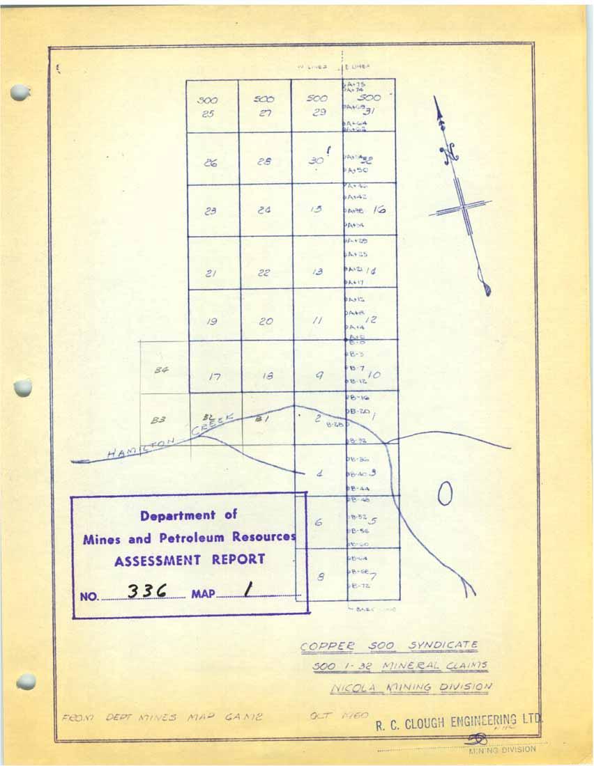
2 TABLE OF CCNTEWTS INTRODUCTION 1 Location and Access 1 Physiography Climate GEOtenOGY RESULTS OF GEOPHYSICAL INVESTIGATIONS GEXERAL PROCEDURES tialysis ACKHOWLELXMENTS RECOMMENDATIONS Department faines and btroleum Resources of AS~ESS;.:2:If REPORT NO. %%~ M&P
3 1. MAGNETOMETER SURVEY OF SO0 MINERAL CLAIMS MERRITT, B.C. THE INTRODUCTION The So0 property, consisting of 32 mineral claims is owned by the Copper Soo Mining Syndicate, a private syndicate incorporated in British Columbia. The period between the latter part of September and. October was spent largely on a magnetometer survey and establishing picket lines on the property. This report and map is compiled from results of this work. The purpose of the geophysical survey was to record or detect any magnetic anomalies on the propertyr- anomalies which would indicate the presence or absence of magnetic minerals primarily magnetite in the bedrock of the mineral claims. A magnetic anomaly located by this geophysical survey would indicate an area deserving detailed attention for copper mineralization has been found associated with magnetite on other claims in the Merritt area. LOCATION AND ACCESS The Soo mineral claims are situated approximately six miles east of Merritt, B. C., at an elevation of approx- V imately 3500 feet. The geographical location may be des-
4 2. cribed as Latitude 50 5'N by Longitude :i20 40'W. The property is readily reached by travelling on provincial highway No. 5 easterly for five miles then by dirt road north for one mile. The nearest supply centre is E4erritt which is' situated on the Nicola River some 130 air miles from the City of Vncouver, B.C. It is serviced by good highways to Kamloops, Princeton and Spence's Bridge, and is on the, Canadian Pacific Railway line. A sketch showing the claim location is enclosed with this report. PBYSIOGRAPHY Drainage of the property is into the Nicola River. The hills are generally rounded and lack the rugged ch;lracter of the mountains further west and south. The ground consists of open range country with occasional patches of alder and some fir on the upper slopes. Undergrowth is light and natural rock exposures are few. CLIMATE The average annual precipitation for this area is inches with somewhat more at higher elevations. The climate in general is considered agreeable with temperatures
5 3. during the summer months reaching looof and during the winter months OOF.
6 4. GEOLOGY According to the Nicola sheet (MAP 886A) of the Geological Survey of Cnada, the claims are underlain by the Nicola Group rocks of Triassic age consisting of volcanos and sediments. The Miocene Coldwater beds bound the claims on the west. Granitic intrusions surround the immediate area, but at a distance of some 4-6 miles. Copper mineralization appears in the area, broadly speaking, along the major fault structures that may be traced from Princeton to Nicola and beyond.
7 5. RESULTS OF GEOPHYSICAL INVESTIGATIONS The purpose of the geophysical survey was to determine the existence of any magnetic anomalies on the property and if so, what was their size and intensity and cause. An anomaly would result from the presence or absence of magnetic mineral magnetite in the rocks being investigated. It is known that copper minerals have been found associated with magnetite or adjacent properties in the Merritt area and for this reason a magnetic anomaly would be an area of interest for possible copper-iron ore bodies and worthy of more detailed attention. Factors which produce variations in vertical magneti.c intensity are:- 1. A concentration of magnetic minerals possibly associated wih valuable minerals. 2. A variation in amount of accessory magnetite in granitic or volcanic bedrock. 3. A variation in amount of magnetite distributed through or connected with the overburden. 4. A variation in depth of non-magnetic overburden on caprock over bedrock having a constant vertical magnetic intensity. 5. Variations in amounts of magnetic minerals in
8 6.. adjacent bands of volcanic and sedimentary rock such as may be expected in Nicola formations which would produce elongated magnetic highs and lows parallel to the formation strike. These variations are not expected to be great. 6. Any combination between variations in magnetic minerals in the rock and variaticsn in the thick- ness of the overlying magnetic or non-magnetic overburden or caprock. It will be seen from the above factors that the evidence of mineralization is not necessarily conclusive from a magnetometer survey one way or another.
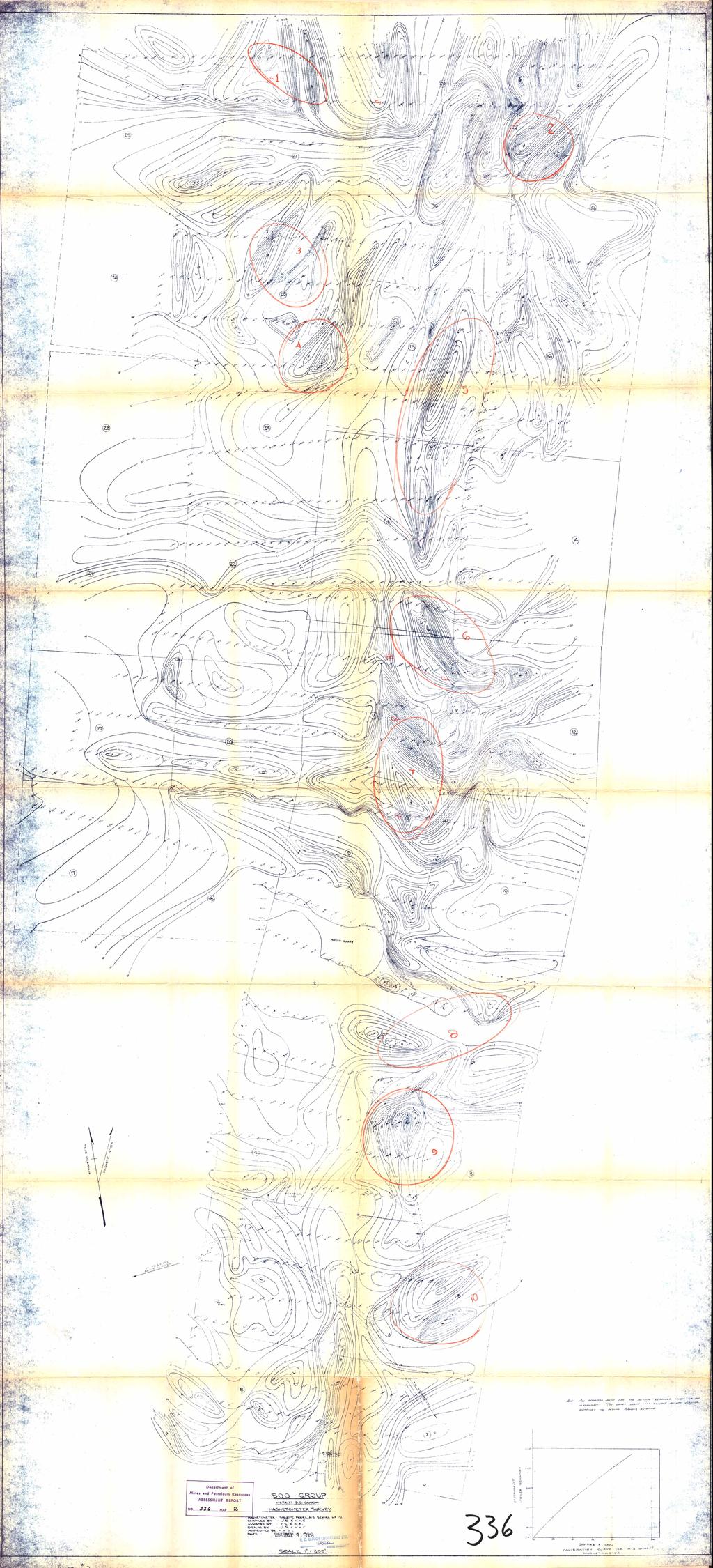
9 7. GENERAL PROCEDURES On the 300 mineral claims, a grid was run on compass headings. The base line extended the entire N. S. length of the claims for 15,000 feet. Cross lines were run at intervals of feet depending on terrain, accessibility, results etc. Readings were taken at 100 foot intervals on the cross lines. 4' pickets - precut, were placed at each 300 foot st.ition and numbered - the designation being the cross line reference and the position or distance east or west of the base line. In this manner, any picket may be used to refer to any location desired. The cross line numbers were the actual distances from a mid-point reference. Readings were recorded in field notes together with any pertinent data such as obvious structural changes in the area, outcrops, rock types observed etc. Data plotted on the map was confined to the geophysical results. This was done in order to avoid cluttering. The other data was used in the analysis of the various features, anomalies and aided'in determining obvious causes of.nomalies (other than mineralization). The contour interval plotted was 100 gammas.
10 8. ANALYSIS Anomalies of interest that occurred were recorded on the map and are as follows:- 1. Northeast section of Soo 27 KC.: a high of 30,000 gammas (1902) was located on line A74 West and A69 West. A cross over to a low of 26,500 gammas in a southerly direction ind~icates an east-west trending structural feature along which possibilities of mineralization do exist..xt the southwest corner of Soo 29 KC., copper mineralization was observed at an outcrop. 2. Anomaly No. 2 is recorded at the northwest corner of Soo 32 M.C. Here a definite cross over does exist perpendicular to the general north-south trending structure. The zone covers an area of 400' x 400'. 3. Anomaly No. 3 is plotted on Soo No. 28: in the north central portion of the claim and is one of great interest. It is a combination of three crossovers indicating a north - south trending deposit or feature having strong polarity. The range is approximately 4,000 gammas between high and low. The features
11 9. I suggest very strongly a series of magnetite zones, possibly associated with copper mineralization, <ind resulting from the two major structural features or contacts - one along the north - south base line, the other along A64 west line. 4. H small anomaly No. 4 is insignificant in itself but is mentioned because it may prove to be related to No No. 5 anomaly, located on Zoo No has a high of 30,000 gammas, ind appears to be a structural feature. This is assumed for the time being in view of the physical shape, but does not eliminate any mineralization possibilities. Definite magnetic influence was experienced on,129 west to A34 west zone on the Brunton compass. 'The outcrops observed show volcanics. (rhyolites and tuffs). 6. Anomaly No. 6 bears investigating - a high of approximately 32,000 gammas, a length of over 600 feet, visl,ble iron sulphides - situated at the northeast corner of Soo 11 M.C. This area is just north of the zone on which w most of the "catwork" had been done during 1959.
12 10. v 7. Anomaly No. 7 extends from the existing trenches on Soo 11 KC. on the Soo 9 KC. The "high" (plus 32,000 gammas) is located to the south of the main trench by 500 feet. A recce in the vicinity revealed copper mineralization in a bluff on line 94 West. The anomaly indicated is quiteprominent, and extends over a distance of SO0 feet north - south. 3. The series of anomalies on Soo 9, 18, 2 are due, in the writer's opinion, to structure w and may be disregarded. 9ome attention mly be given to the anomaly on Soo 1 KC. (No. 8) whose behavior is rather interesting in that a change does take place between the north and south extremities of the anomaly. The high reading is 31,500 gammas. 9. No. 9, located on Soo 3 41.C. was traversed by the road, and indicates.a zone 400' x 400' in area that c uld qualify as a potential sulphide zone. Overburden prevented any geological study to ascertain the cause of the anomaly. 10. Anomaly No. 10 is on Soo No. 5 M.C. just
13 11. east of the dirt road. It appears to have a possibility of sulphide mineralization. however, the writer feels (due to the surface expression) that structural contracts are partly responsible for the readings recorded.
14 12. ACKNOWLEDGMENTS The writer wishes to express his gratitude to the directors of the Copper Soo Mining Syndicate, in particular Mr. T. 0. Wilson of Osoyoos, B.C., for the opportunity to investigate the Soo mineral claims, and to Messrs. Shutz, Soltice and Ewers, for their assistance and co-operation in the field.
15 13. RECOMMENDATIONS In view of the high readings recorded by the magnetometer survey of the area, the more important or more prominent anomalies are worthy of further investigation. Several instances of new copper mineralization have been discovered while traversing the area, and there is a possibility that the anomalies located magnetically, are associated -w;:a the copper mineralization, and may lead to uncovering bodies of ore grade mineralization. It is recommended that a program be instigated whereby at least the major or more prominent anomalies be investigated further. This may be accomplished by:- 1. Employing a diamond drill to investigate at depth, the characteristics of Anomalies Nos. 7, 6, 1 primarily, and others at a later date, depending upon the results of the first drilling stage. No less than three holes should be drilled on each anomaly, and the depth of penetration should aggregate possibly 1,000 feet (3 holes). k total of 3,000 feet of drilling, therefore, should be a minimum~reguirement and the data obtained would dictate any future program. If "ore" is discovered to be responsible for the anomalies, then a major
16 14. drilling program would be instigated in com- bination with a further geophysical (electrical method) examination. Drilling is favored at the present in preference to an electrical survey. The electrical survey would duplicate any anomalies due to magnetite, and indicate others due to non-magnetic sulphides, and too, would be influenced by the underlying coal seams at the west boundary of the claims. The drilling would reveal immediately the rock types and structure of the anomalous areas. 2. A limited amount of "catwork" can be carried out on the other anomalies - a trench - readily cut through the shallow layer of overbu:rden may indicate the "cause" of the anomaly and'assist in supplying valuable structural information. The cost of this stage of exploratory work is estimated as follows: Diamond drilling, 3,000 feet 3 $80 $ 24,000 Catwork - 1 week 1,000 Supervision, engineering, core logging Assays, misc. core boxes, supplies 1,500 1,500 $ 28,000 Contingencies 2,000 TOTAL $ 30,000
17 t COPPER SO0 31INING SYNDICATE 1. Nature Of Report: Geophysical 2,Names Of Claims: 3.Author: 1-32 M.C. 1-4 M.C. Nicola brining Division Latitude 50' 51 N Longitude 120' 351 w 11. C. Clough En&ineering Ltd. Harvey H. Cohen,?.2ng. 4. Ownership: T G.I*(ilS*tq ) %ustce, (Copper Soo Mining Syndicate) Osoyoos, B.C. 5, Dates: August 31 - September 5 September 19 - September 26 October 3 - November
18 DETAILS OF EXPENDITURES August 31 - November 9 GEOPHYSICAL REPORT: Soo 1-32 Mineral Claims Bear l-4 Nicola Mining Division RECONNAISANCE, ESTABLISHING BASE LINES lind CROSSLImS SETTING PICI(ETS AND STATIONS: XAGNETOM~TER SURVEY: J. Schutz X. Ewers F. Soltice H. Cohen J. Schutz II. Ewers F. Soltice IS. Cohen * Mappine REPORT: Fees: H. Cohen J. Schutz H. Cohen
19
20
Introducti on. Land Survey. Geomagnetic Survey. Geomagnetic Results and Interpretati ons - Conclusions and Recommendations C
 m M 42A86SW8281 63.42 PRICE 010 C O H T E H l 42A86SW828I 63.42 PRICE 010C Introducti on Land Survey Geomagnetic Survey Geomagnetic Results and Interpretati ons - Conclusions and Recommendations - - -
GEOPHYSICAL SURVEY WHITEY AND H GROUP MINERAL CLAIMS KEEN CREEK AREA, SLOCAN MINING DIVISION ANDEX MINES LTD. VANCOWER, B.C.
 R E P O R T ON THE GEOPHYSICAL SURVEY WHITEY AND H GROUP MINERAL CLAIMS KEEN CREEK AREA, B.C. SLOCAN MINING DIVISION ANDEX MINES LTD. VANCOWER, B.C. Andex Mines Ltd., 315-543 Granville Street, Vancouver,
Summary of Rover Metals Geologic Mapping Program at the Up Town Gold Project, Northwest Territories
 October 13, 2017 Summary of Rover Metals Geologic Mapping Program at the Up Town Gold Project, Northwest Territories Vancouver, British Columbia, Canada - Rover Metals Corp., Rover, is pleased to provide
2013 GEOLOGICAL ASSESSMENT REPORT SHERIDAN HILL PROPERTY
 2013 GEOLOGICAL ASSESSMENT REPORT ON THE SHERIDAN HILL PROPERTY NEW WESTMINSTER MINING DIVISION BRITISH COLUMBIA NTS 092G07 49 16 31 NORTH LATITUDE, 122 39 48 WEST LONGITUDE PREPARED FOR Sheridan Hill
GEOCHEMICAL REPORT ON A SOIL SAMPLING SURVEY OF PORTIONS OF THE KR GROUP OF MINERAL CLAIMS OF PLATEAU METALS LIMITED.
 GEOCHEMICAL REPORT ON A SOIL SAMPLING SURVEY OF PORTIONS OF THE KR GROUP OF MINERAL CLAIMS OF PLATEAU METALS LIMITED By Kol Lovang Christopher Riley, P. Eng., Supervisor c Vancouver, B. c. Work Performed:
J.D. Mason, Prof. Engineer. Report on the Reconnaissance Magnetometer Survey. Completed for. North American Platinum Corporation Ltd.
 Report on the Reconnaissance Magnetometer Survey Completed for North American Platinum Corporation Ltd. Olivine Mountain Property, Tulameen, B.C. J.D. Mason, Prof. Engineer. November 28, 1967. Certificate
NICOLA M.D King Street West, April, 1969 AMALG 1-44 MINERAL CLAIMS 1. OWNER: Dr. F. R. Burton, W. M. Sirola, P. Eng.
 REPORT ON ' MAGNETIC AND ELECTROMAGNETIC SURVEY AMALG 1-44 MINERAL CLAIMS 1. NICOLA M.D. 49'501 N - 12Oo57f W OWNER: Dr. F. R. Burton, 1506-44 King Street West, Toronto 1, Ontario. by W. M. Sirola, P.
Assessment Work Report. on the Geophysical Surveys carried out over the
 Assessment Work Report on the Geophysical Surveys carried out over the PINE GROUP of Mineral Claims 951-J-15-W Lillooet Mining Division Goldbridge, B.C. Long 122 48' Lat. 50 48' by Levon Resources Ltd.
7 MILES WEST OF PORT HARDY, B.C.
 GEOPHYSICAL REPORT VERTICAL INTENSITY MAGNETOMEER SURVEY ON LUK CLAIMS, 7 MILES WEST OF PORT HARDY, B.C. 50' 127O SE BY R. E. SHIELDS UNDER SUPERVISION OF J. R. BILLINGSLEY FOR SECOND0 MINING LTD. (N.
GEOCSZNICAL - SURVEY. ICAMLOOPS Kl.D. 2'' 6;kr. HY "'f. Alfred R. Allen,P.Eng. 1 NO.%=...,... 6"- 'I.
 t i.i GEOCSZNICAL - SURVEY i p' ICAMLOOPS Kl.D. 2'' 6;kr HY 50-64 +."'f 121-51 NE 5-10-70 : 19-10-70 Alfred R. Allen,P.Eng. I) ' 1 6"- 'I. 1 NO.%=...,..... Q.C. EXPLORATIONS LTD. 2Cl- 535 Kowe Street Vancouver
Canadian National Railways tracks from the foot bridge across the. Thompson River from the Trans Canada Highway. A pick-up truck was used
 Canadian National Railways tracks from the foot bridge across the Thompson River from the Trans Canada Highway. A pick-up truck was used on the highway side and a h-wheel drive Jeep was transported by
GEOPHYSICAL REPORT CHU CHUA PROJECT Green Mountain Group. KAMLOOPS MINING DIVISION NTS 92P/8E, 82M/5W Lat: 51'24' N Long: 120'00' w
 I GEOPHYSICAL REPORT CHU CHUA PROJECT Green Mountain Group KAMLOOPS MINING DIVISION NTS 92P/8E, 82M/5W Lat: 51'24' N Long: 120'00' w I rvm #.,_..._..._._._.- $...-...! 1 VANCOUVER, B.C. 1 G E 0 I, 0.G
490 20' 30" North Latitude ' 30" West Longitude
 _._.. I CONSULTING GEOLOGISTS 605-602 WEST HASTINGS STREET, VANCOUVER, B.C. V6B 1P2 TELEPHONE: (604) 689-5533 6 I F: ASSESSMENT REPORT ON THE PATSY 1 MINERAL CLAIM ' '?%2% I WHISTLE CREEK, HEDLEY ARE L-l-
Gold Mountain Group Gold Mtn. A, B, C & D Mineral Claims Record Nos. 697, 698, 699 & 700. Island Mountain Cariboo Mining Division British Columbia
 GOLD POINT RESOURCES LTD. Geophysical Survey Gold Mountain Group Gold Mtn. A, B, C & D Mineral Claims Record Nos. 697, 698, 699 & 700 Island Mountain Cariboo Mining Division British Columbia Vancouver,
REPORT. on the. Omineca Mining Division, British Columbia. Latitude N., Longitude W. NTS map sheet 93F/7E. James W. McLeod, P.Geo.
 REPORT on the CHU MOLYBDENUM PROPERTY Omineca Mining Division, British Columbia Latitude 53 21 N., Longitude 124 37 W. NTS map sheet 93F/7E James W. McLeod, P.Geo. on behalf of Mr. Chris Delorme TABLE
GEOPHYSICAL REPORT. Airborne Magnetometer Survey. of the SHEEP-GOAT GROUP OF MINERAL CLAIMS. near Li l looet, B.C.
 GEOPHYSICAL REPORT 977 Airborne Magnetometer Survey of the SHEEP-GOAT GROUP OF MINERAL CLAIMS near Li l looet, B.C. Lillooet Mining Division (Lat.51 'lot Long. 122 40' 7 5t0[2L05E. for DUFFEY LAKES MINES
compietea since tnat date, and wnicn comprisea btage I ot tne recommended
 compietea since tnat date, and wnicn comprisea btage I ot tne recommended four-stage program. GEOLOGY & MINERALIZATION The property situate6 on the southeast slope of Nickel Plate Mtn., and within the
I PRELIMINARY MAGNETOMETER SURVEY
 .REPORT O N I PRELIMINARY MAGNETOMETER SURVEY and GEOLOGICAL RECONNAISSANCE L AND K GROUP OF CLAIMS Located 8 Miles East of Princeton, B. C. Similkameen Mining Division Lat. 49' 27' N. Long. 120' 16' W
December 6th I960. President and Directors, Chipman Lake Mines Ltd. 25 King Street West, Toronto.
 OFFICE: EM, 3-3933 RES.: HU. 1-1265 "' Mfc 42A85NE0127 63.1089 GODFREY 010. D. President and Directors, Chipman Lake Mines Ltd. 25 King Street West, Toronto. December 6th I960 REPORT ON GEOPHYSICAL SURVEY
REPORT ON MAGNETOMETER SURVEY TIK-1 CLAIM e&f KAMLOOPS MINING DTVISION. by D. Hendry D. C. MILLER. February 3, for
 REPORT ON MAGNETOMETER SURVEY TIK-1 CLAIM 92-1-14 e&f KAMLOOPS MINING DTVISION lat. 50 57 ' 12" long. 121O23 ' 37" OWNER: ST. JOSEPH EXPLORATIONS LIMITED OPERATIOR: ST. JOSEPH EXPLORATIONS LIMITED by D.
SUPPLEMENT TO MAGNETOMETER 6 ELECTROMAGNETIC SURVEY REPORT. DATED NOVEMBER l, 1973 CIGLEN INVESTMENTS LIMITED CLAIMS GROUP BAD VERMILLION LAKE AREA
 ^ A R l ^ 1974 010 PROJECTS UNIT SUPPLEMENT TO MAGNETOMETER 6 ELECTROMAGNETIC SURVEY REPORT DATED NOVEMBER l, 1973 CIGLEN INVESTMENTS LIMITED CLAIMS GROUP BAD VERMILLION LAKE AREA DISTRICT OF RAINY RIVER
lat ' N Long ' W
 305 7 ec1;, REPORT ON THE JERY CLAIMS OF POLA RESOURCES LTD. NTS 93L/16 0 0 lat. 54 45' N Long. 126 22' W BABIXE LAKE AREA OMINECA MINING DIVISION, B.C. PAUL PLICKA CONSULTING GEOLOGIST DECEMBER 30, 1981
ASSESSMENT' REPORT GEOPHYSICAL REPORT ON THE ATTORNEY 2 CLAIM (4 UNITS) OMINECA MINING DIVISION SHEILA A. CRAWFORD.
 OMINECA MINING DIVISION SHEILA A. CRAWFORD.") ASSESSMENT' REPORT GEOPHYSICAL REPORT ON THE ATTORNEY 2 CLAIM (4 UNITS) OMINECA MINING DIVISION by SHEILA A. CRAWFORD LOCATION: 57z17' N Latitude 127 11' W Longitude N.T.S. 94E/6E OWNER/OPERATOR: SEREM
ASSESSMENT' REPORT GEOPHYSICAL REPORT ON THE ATTORNEY 2 CLAIM (4 UNITS) OMINECA MINING DIVISION by SHEILA A. CRAWFORD LOCATION: 57z17' N Latitude 127 11' W Longitude N.T.S. 94E/6E OWNER/OPERATOR: SEREM
The survey covered claims, in part or in full, DUCKLING 3, 4, 5, 4 fraction, and 5 fraction.
 514 687-6671 XXX- 602 West Hastin~a StroeP, Vata;sn@ouver, BritlsA fhlum~b~a, Garaadsa B81apphgtaa DISCUSS ION OF MAGNETOMETER SURVEY ON DUCKLING CLAIMS FOR DONNA MINES LTD. (N0P.L.) Submitted to: DONNA
Geology 12 FINAL EXAM PREP. Possible Written Response Exam Questions
 Geology 12 FINAL EXAM PREP Possible Written Response Exam Questions Use this study guide to prepare for the written response portion of the final exam. Name FINAL EXAM - POSSIBLE WRITTEN RESPONSE QUESTIONS
3 I1 I I Ill 111 II! II 111 II Ill I IlE I I P I
 -7 3 1 1 11111111111111111111111111111111 ll 111! 111 111 111 111 111111111111111 ll 1111111 1 11111111111111 le P GEOCHEMCAL SURVEY OF THE KE AND D'ARCY CLAM GROUPS.. Similkameen Mining Division, B.C.
OSOYOOS UINING DIVISION. 49% - 20' North Latitude 120% - 05' West Longitude. GOOD HOPE RESOURCES LTD West Hastings Street Vancouver, B. C.
 REPORT ON HORSEFLY PROPERTY DIAMOND DRILLING - 1982 OSOYOOS UINING DIVISION 49% - 20' North Latitude 120% - 05' West Longitude 9 x It/YG FOR GOOD HOPE RESOURCES LTD. 1518-1177 West Hastings Street Vancouver,
PHOENIX GEOPHYSICS LIMITED REPORT ON THE VLF-EM AND TOTAL FIELD MAGNETOMETER SURVEYS ON THE
 PHOENIX GEOPHYSICS LIMITED REPORT ON THE VLF-EM AND TOTAL FIELD MAGNETOMETER SURVEYS ON THE TAN CLAIMS, CHILLIWACK AREA NEW WESTMINSTER MINING DIVISION, BRITISH COLUMBIA FOR LORNEX MINING CORPORATION LIMITED
PROSPECTING REPORT. Deneau Creek. EVENT # TENURE # Tenure Name: Deneau Creek. New Westminster Mining Division Map 092H
 2010-2011 PROSPECTING REPORT Deneau Creek EVENT # 4844921 TENURE # 578616 Tenure Name: Deneau Creek New Westminster Mining Division Map 092H Central Coordinate Reference 121 18 04.5 W Longitude 49 26 13.9
GEOLOGICAL MAPPING REPORT ON THE ASH MINERAL CLAIM OSOYOOS MINING DIVISION ASHNOLA RIVER MAP SHEET NTS M092,H019 MCBRIDE CREEK AREA, ASHNOLA RIVER,
 GEOLOGICAL MAPPING REPORT ON THE ASH MINERAL CLAIM OSOYOOS MINING DIVISION ASHNOLA RIVER MAP SHEET NTS M092,H019 LATITUDE 49 o O6, LONGITUDE 120 o 22 MCBRIDE CREEK AREA, ASHNOLA RIVER, KEREMEOS, B.C. CANADA
UNION MINIERE EXPLORATIONS AND MINING CORPORATION LIMITED ASSESSMENT REPORT ON FITINAT MINERAL CLAIM. Alberni Mining Division Record No.
 M F )( UNION MINIERE EXPLORATIONS AND MINING CORPORATION LIMITED Suite 200, 4299 Canada Way, Burnaby, B.C. V5G 1 H4 Telephone (604) 437-9491 ASSESSMENT REPORT ON GEOCHEMICAL SOIL SURVEYS AND ROCKSAMPLING
POTENTIAL OF THE DONGWE COPPER GOLD PROJECT
 POTENTIAL OF THE DONGWE COPPER GOLD PROJECT By Nathan Sabao, P.Geo. September 2015 1 TABLE OF CONTENTS Page 1.0 EXECUTIVE SUMMARY 1 2.0 LOCATION 2 3.0 ACCESS 2 4.0 GEOLOGY 3 5.0 PREVIOUS DRILLING 5 6.0
GEOPHYSICAL REPORT THE CAVZ CLAIMS
 GEOPHYSICAL REPORT Magnetometer Survey on THE CAVZ CLAIMS CAVZ M.C.'s 1 to 12, 15 to 26, 29 to 40, 45 to 54 Trail Peak, Omineca M.D. 13 miles northeast of Fort Babine 550 ) 126 S.E. by G.Podolsky J.Russell
Assessment Report by the Canadian Nickel Co. Ltd. Magnetometer Survey. Larder Lake Mining Division Lebel Tovnship, Ontario
 32084Nwea67 2.331* LEBEL 010 Assessment Report by the Canadian Nickel Co. Ltd. Magnetometer Survey Larder Lake Mining Division Lebel Tovnship, Ontario Claims L-531657 L-531658 L-531111 Map No.: M-359,
The SL group is located 10 miles east of Lac La Hache and can be reached by good secondary roads.
 0 Summary Soil samples were collected and analyzed for trace mercury vapour content over a magnetic and electromagnetic anomaly. Weak positive evidence of base metal mineralization was obtained. Location
PROSPECTING REPORT. Broken Hill Property. EVENT # TENURE # Tenure Name: Broken Hill. New Westminster Mining Division Map 092H
 2009-2010 PROSPECTING REPORT Broken Hill Property EVENT # 4514071 TENURE # 600988 Tenure Name: Broken Hill New Westminster Mining Division Map 092H Central Coordinate Reference 121 24 26.2 W Longitude
PROSPECTORS ASSISTANCE PROGRAM MINISTRY OF ENERGY AND MINES
 BRITISH COLUMBIA PROSPECTORS ASSISTANCE PROGRAM MINISTRY OF ENERGY AND MINES GEOLOGICAL SURVEY BRANCH PROGRAM YEAR: 1999/2000 REPORT #: PAP 99-l 6 NAME: KIM ANSCHETZ PROSPECTORS TlEPORT on the 99 LOUIS
1 FILMED 1. FILE NO:!..rsrru -* -. GRAND TWO CLAIM
 FILE NO:!..rsrru -* -. GRAND TWO CLAIM REPORT ON 1993 ASSESSMENT WORK GRAND TWO CLAIM REC. NO. 301849 NELSON MINING DIVISION NTS MAP SHEET 82F6/W 49 25'51" NORTH 117 18'08" WEST 1 FILMED 1 AUTHOR: R. Jordan,
W. 1.NELSON Jr. P. ENG.
 GEOCHEMICAL AND GEOPHYSICAL SURVEY SNO GROUP CLAIMS W. 1.NELSON Jr. P. ENG. NORANDA EXPLORATION COMPANY, LIMITED OMINECA MINING DIVISION AUG. 17, 1971 - AUG. 29, 1971 TABLE OF CONTENTS - Page INTRODUCTION
Northern Chile, 170 km SE of Antofagasta Centred km S-SW of the giant La Escondida Mining District (BHP Billiton & Rio Tinto)
") October 2017 Block 3-Culebra is a large property block situated along the Domeyko Cordillera porphyry copper belt in northern Chile, which is host to some of the world s largest copper deposits and mines.
October 2017 Block 3-Culebra is a large property block situated along the Domeyko Cordillera porphyry copper belt in northern Chile, which is host to some of the world s largest copper deposits and mines.
42H88SW NEWMAN
 42H88SW0003 63.8199 NEWMAN 010 TRIPOINT MINES LIMITED, Suite 305-100 Adelaide St. West, Toronto l, Ontario. Gentlemen: Your Company recently conducted a combined magneticelectromagnetic survey over a ten
Amador Canyon Silver Mining Property Lander County, NV
 Amador Canyon Silver Mining Property Lander County, NV Over $1 million worth of exploration and evaluation work performed Favorable drill results including a return of 286 g/ton silver over 12.2 meters
REPORT ON GEOPHYSICAL SURVEYS ON THE BAMAJI LAKE PROPERTY CROBIE PROJECT, NW ONTARIO OF UMEX INC.
 S20e3NWe«28 S20«3NWee37 FRY LAKE 0 1 0 REPORT ON GEOPHYSICAL SURVEYS ON THE BAMAJI LAKE PROPERTY CROBIE PROJECT, NW ONTARIO OF UMEX INC. Patricia Mining Division NTS 52 0/3 Latitude 51 10'N Longitude 91
CONTENTS. Location, Access and History...6. Tenure Status and Geology Regional Andy Property Geology Map...9
 TYPE OFWORK IN THIS REPORT EXTENT OF WORK (rn METRTC UNITS) ON WHICH CLAIMS PROJECT COSTS APPORTIONED (incl. support) GEOLOGICAL (scale, area) Ground, mapping Photo interpretation GEOPHYSICAL (line-kilometres)
BALFOUR MINING LTD. (N.P.L.) HAM GROUP 92-P-6, CLINTON M. D.8 B. C. Lat 51 17'N, GEOCHEMICAL REPORT. V. CUKOR, P. Eng.
 HAM GROUP 92-P-6, CLINTON M. D.8 B. C. Lat 51 17'N, GEOCHEMICAL REPORT. V. CUKOR, P. Eng.") 34q '7 BALFOUR MINING LTD. (N.P.L.) HAM GROUP 92-P-6, CLINTON M. D.8 B. C. Lat 51 17'N, Long 12lo14'W GEOCHEMICAL REPORT, V. CUKOR, P. Eng. January 31, 1972 TABLE OF CONTENTS 1. INTRODUCTION 2. PROPERTY,
34q '7 BALFOUR MINING LTD. (N.P.L.) HAM GROUP 92-P-6, CLINTON M. D.8 B. C. Lat 51 17'N, Long 12lo14'W GEOCHEMICAL REPORT, V. CUKOR, P. Eng. January 31, 1972 TABLE OF CONTENTS 1. INTRODUCTION 2. PROPERTY,
MODERN GEOPHYt INTRODUCTION
 MODERN GEOPHYt SUITE 5-13 ADELAIDE ST. E. TORONTO - ONTARIO 42A06SE8121 63.1009 ELDORADO 0 10 JU*Jkl.TJLA. JL JL^A^r GEOPHYSICAL SURVEYS ELECTROMAGNETIC (VERTICAL 8r HORIZONTAL) TELEPHONE: MAGNETIC EMPIRE
Report. Mining Claim SO Butt Township. District of Nipissing. Southern Ontario Mining District. Richard Keevil ~ Geologist. August 29,2006.
 Report On Mining Claim SO 1077365 Butt Township District of Nipissing Southern Ontario Mining District ~ "'_I ""'..1 D I..:"'.U&O... ~u ~]. Richard Keevil ~ Geologist August 29,2006. Richard R. Keevil,
OEOMAQNETIC SURVEI QUIBORD TOWNSHIP GROUP #2 HOLLINGER CONSOLIDATED GOLD MINES, LTD.
 OEOMAQNETIC SURVEI QUIBORD TOWNSHIP GROUP #2 HOLLINGER CONSOLIDATED GOLD MINES, LTD. 42Ae9SE0268 63.1502 GUIBORD (711(71 Introduction During the period January 5 - February 26, 1965, a magnetometer survey
GEOL.3250 Geology for Engineers Plate Tectonics - Geomagnetism, Earthquakes, and Gravity
 Name GEOL.3250 Geology for Engineers Plate Tectonics - Geomagnetism, Earthquakes, and Gravity I. Geomagnetism The earth's magnetic field can be viewed as a simple bar magnet located near the center of
ENGINEER S CERTIFICATION OF FAULT AREA DEMONSTRATION (40 CFR )
") PLATTE RIVER POWER AUTHORITY RAWHIDE ENERGY STATION BOTTOM ASH TRANSFER (BAT) IMPOUNDMENTS LARIMER COUNTY, CO ENGINEER S CERTIFICATION OF FAULT AREA DEMONSTRATION (40 CFR 257.62) FOR COAL COMBUSTION RESIDUALS
PLATTE RIVER POWER AUTHORITY RAWHIDE ENERGY STATION BOTTOM ASH TRANSFER (BAT) IMPOUNDMENTS LARIMER COUNTY, CO ENGINEER S CERTIFICATION OF FAULT AREA DEMONSTRATION (40 CFR 257.62) FOR COAL COMBUSTION RESIDUALS
SURVEY OF CLOSED AND ABANDONED MINES IN BRITISH COLUMBIA FOR ACID ROCK DRAINAGE I: REGIONAL PERSPECTIVE ABSTRACT
 SURVEY OF CLOSED AND ABANDONED MINES IN BRITISH COLUMBIA FOR ACID ROCK DRAINAGE I: REGIONAL PERSPECTIVE Stephen J. Day 1 and David P. Harpley 2 1 Norecol Environmental Consultants Ltd. 700-1090 West Fender
Report of Gridding and Magnetic Surveys. On the. Munro Property. Munro and Beatty Townships, Ontario. Larder Lake Mining Division
 Report of Gridding and Magnetic Surveys On the Munro Property Munro and Beatty Townships, Ontario Larder Lake Mining Division Claims: 39 4244 For Big Red Diamond Corporation October 3, 2 Timmins, Ontario
1 CLAIMS GEOPHYSICAL REPORT ON BOYAL SITUATE NORTHEAST OF TILLICUM MOUNTAIN GOLD AREA BURTON - NAKUSP SIQCAEJ MINING DIVISION
 GEOPHYSICAL REPORT ON BOYAL 1 CLAIMS SITUATE NORTHEAST OF TILLICUM MOUNTAIN GOLD AREA BURTON - NAKUSP SIQCAEJ MINING DIVISION CONSULTING GEOLOGIST AUGUST 1983 VANCOUVER B *C INDEX INTRODUCTION ooa,.eoaaa.aaaoaaooaoa~ao~o
PROSPECTING REPORT THE WALLACE CLAIM OMENICA MINING DIVISION. 54" x6" 3.d d. for. Reako Exlorat ions Ltd. Wallace Rev. C.G.
 PROSPECTING REPORT ON THE WALLACE CLAIM OMENICA MINING DIVISION 54"44 14 1x6" 3.d d by David A. Howard P.Eng. for Reako Exlorat ions Ltd. Claim Locat ion Wallace Rev. C.G. #1560 Dome Mountain Area 9 3
MEMORANDUM. Interpretation of Magnetic and Volterra-3DIP survey MC Claims
 11966 95A Avenue, Delta, BC V4C 3W2 Canada Tel +1 (604) 582-1100 www.sjgeophysics.com MEMORANDUM Date: September 13, 2017 From: To: SUBJECT: E. Trent Pezzot Bonanza Mining Corporation Interpretation of
COOMALIE RIDGES RADIOMETRIC SURVEY, RUM JUNGLE AREA,
 COMMONWEALTH OF AUSTRALIA DEPARTMENT OF NATIONAL DEVELOPMENT BUREAU OF MINERAL RESOURCES, GEOLOGY AND GEOPHYSICS RECORD No. 1966/51 500917 COOMALIE RIDGES RADIOMETRIC SURVEY, RUM JUNGLE AREA, NORTHERN
=%REPORT RECONNAISSANCE OF CHISHOLM LAKE PROSPECT. October 25, 1977
 =%REPORT ON FIELD RECONNAISSANCE OF CHISHOLM LAKE PROSPECT October 25, 1977 Bruce D. Vincent Imperial Oil Limited, Minerals - Coal, CALGARY, ALBERTA CHISHOLM LAKE PROSPECT Introduction The Chisholm Lake
HELICOPTER MAGNETIC SURVEY MISINCHINKA RANGE AREA, B.C. ONINECA MINING DIVISION. on behalf of STOKES EXPLORATION MANAGEMENT LTD.
 HELICOPTER MAGNETIC SURVEY MISINCHINKA RANGE AREA, B.C. ONINECA MINING DIVISION on behalf of STOKES EXPLORATION MANAGEMENT LTD. Claims : FALCON $1, FALCON #2 Location: Dated: About 7% kilometers N.E. of
GEOLOGICAL MAPPING OF SKARNS ON THE SHEEP AND EWE CLAIMS, TURNAGAIN RIVER, B.C. DURING THE 1979 SUMMER SEASON
 GEOLOGICAL MAPPING OF SKARNS ON THE SHEEP AND EWE CLAIMS, TURNAGAIN RIVER, B.C. DURING THE 1979 SUMMER SEASON CLAIMS: Sheep 1 to 4 Ewe 1, 3, 4 to 8 Lamb 12 Fraction Liard Mining Division, B.C. NTS 104
FILE NO. ASSESSMENT REPORT VLF-EM GEOPHY S I CS BUCK CLAIMS. Moyie River and Perry Creek Area FORT STEELE MINING DIVISION. NTS 82 F/8 E and 82 G/5 W
 FILE NO. ASSESSMENT REPORT on - VLF-EM GEOPHY S I CS BUCK CLAIMS Moyie River and Perry Creek Area FORT STEELE MINING DIVISION NTS 82 F/8 E and 82 G/5 W Latitude 49 27' N Longitude 116 03' W PETER KLEWCHUK
Beekeeper Property The Geology South of Mint Lake. Cariboo Mining Division
 Beekeeper Property The Geology South of Mint Lake NTS: 93A/6 Cariboo Mining Division Claims: Beekeeper 1 #I2055 Beekeeper 2 #3892 Beekeeper 3 #7895 Beekeeper 4 #8503 Latitude: Longitude: 52 degrees 24
ASSESSMENT REPORT N 0. REPORT ON HORIZONTAL COPLANAR LOOP ELECTROMAGNETIC SURVEY HOUSTON AREA OF BRITISH COLUMBIA AQUITAINE COMPANY OF CANADA DURING
 tf 62 33 REPORT ON HORIZONTAL COPLANAR LOOP ELECTROMAGNETIC SURVEY IN THE HOUSTON AREA OF BRITISH COLUMBIA BY AQUITAINE COMPANY OF CANADA c DURING MARCH 21 - MARCH 25, 1977 MINERAL RESOURCES BRANCH ASSESSMENT
BUREAU OF MINERAL RESOURCES GEOLOGY AND GEOPHYSICS.
 COMMONWEALTH OF AUSTRALIA. DEPARTMENT OF NATIONAL DEVELOPMENT. BUREAU OF MINERAL RESOURCES GEOLOGY AND GEOPHYSICS. RECORDS: 1962/33 GEOLOGY OF THE B.W. IRON CLAIM, HUNDRED OF WATERHOUSE, NORTHERN TERRITORY.
DRILLING REPORT ON THE HIGHLAND VALLEY, KAMLOOPS MINING DIVISION, OWNED BY GAZA MINES LTD., NEW JERICHO DEVELOPMENT AND TECK CORPORATION
 DRILLING REPORT ON THE GAZA 1 AND JERICHO 1 AND 2 MINERAL CLAIMS / (RECORD NUMBERS 159, 492 AND 161) HIGHLAND VALLEY, KAMLOOPS MINING DIVISION, LATITUDE 50' 26' N; LONGITUDE 120' 55' W; NTS 92-I/7W OWNED
GEOLOGICAL BRANCH ASSESSMENT REB(3,R.T
 GEOPHYSICAL REPORT on the PHANTOM CLAIMS 2-3 CARIB00 MINING DIVISION N.T.S. 93B/16 East by H. Limion, Chief Geophysicist J. A. Turner, Geologist January 1983 CLAIMS OWNED BY: WORK DONE BY: Newmont Exploration
Prospecting Report 'S Office i DB Property, B.C. -J Negro Creek Nelson Mining District NTS 82F.050. Operator: Kootenay Gold Inc.
 . '.' I"' i9 12 Prospecting Report 'S Office i DB Property, B.C. -J Negro Creek Nelson Mining District NTS 82F.050 Operator: Kootenay Gold Inc. Owner: Darlene Lavoie Work Performed Summer of 2007 Report
between F.J. on the 0H)PHYSICAL and GPX)CIiEMICAL SURVEYS of part of the sa.& SSmRT FIVE MILES SOUTH of GREENWOD, B.C. FIELD WORK DONE FOR
PHYSICAL and GPX)CIiEMICAL SURVEYS of part of the sa.& SSmRT FIVE MILES SOUTH of GREENWOD, B.C. FIELD WORK DONE FOR") FRED J. HEMSWORTH MINING ENGINEER 616 CREDIT FONCIER BLDG. 850 WEST HASTINGS STREET VANCOUVER 1, B.C. SSmRT on the 0H)PHYSICAL and GPX)CIiEMICAL SURVEYS of part of the LM-C GRDUP Of MINERAL CIAIN FIVE
FRED J. HEMSWORTH MINING ENGINEER 616 CREDIT FONCIER BLDG. 850 WEST HASTINGS STREET VANCOUVER 1, B.C. SSmRT on the 0H)PHYSICAL and GPX)CIiEMICAL SURVEYS of part of the LM-C GRDUP Of MINERAL CIAIN FIVE
A PRELIMINARY REPORT ON THE ZYMOST2 CLAIM GROtP, TERRACE, B.C.
 NATIVE EXPLORATIONS LTD. A PRELIMINARY REPORT ON THE ZYMOST2 CLAIM GROtP, TERRACE, B.C. INTRODUCTION': The Zymoetz claim group is, at present, held under option by Native Explorations Ltd.. On the 19th
PROSPECTING REPORT. Silver Dollar Property. EVENT # TENURE # Tenure Name: GPEX Silver Dollar
 2008-2009 PROSPECTING REPORT Silver Dollar Property EVENT # 4267989 TENURE # 555462 Tenure Name: GPEX Silver Dollar Similkameen Mining Division Map 092H Central Coordinate Reference 120 06 26.9 W Longitude
GEOLOGICAL REPORT and MAGNETOMETER SURVEY 1-34 December 1 to.3, 1973 SIMILKAMEEN MINING DIVISION 'W, 49O 36'N.
 4 03' GEOLOGICAL REPORT and MAGNETOMETER SURVEY on @CLAIMS 1-34 December 1 to.3, 1973 SIMILKAMEEN MINING DIVISION 120 21'W, 49O 36'N w f Cepartmcnt of Mines 22.2 Pe>rsi-.um Resources I.., A43~J~lr,~r.'F
ASSESSMENT REPORT MAGNETOMETER SURVEY GOLDEN ROD, GOLDEN ROD #2. Long.: General Delivery, Vananda, B. C.
 ASSESSMENT REPORT MAGNETOMETER SURVEY GOLDEN ROD, GOLDEN ROD #2 t=/ NTS 92~110w Lat.: Long.: 49O 44' N 124O 34' W Owner: E. Johanson General Delivery, Vananda, B. C. Operator: Rhyolite Resources I nc.
"SEVEN-MILE" AND ADJACENT IRON ORE DEPOSITS,
 COMMONWEALTH OF AUSTRALIA DEPARTMENT OF NATIONAL DEVELOPMENT BUREAU OF MINERAL RESOURCES, GEOLOGY AND GEOPHYSICS RECORDS 1956, N. 76 MAGNETIC SURVEY OF THE "SEVEN-MILE" AND ADJACENT IRON ORE DEPOSITS,
for the Greenwood Mining Division, B.C. NTS 82E/7W Latitude 49' 27' W, Longitude 118' 5 Prepared by a= D. Dylan Watt, B.Sc.
 t. b LOGnO: 37~ -08 m. ACTIO#: for the AMP AMP 2 AMP 3 t AMP 4 CLAIMS Greenwood Mining Division, B.C. NTS 82E/7W Latitude 49' 27' W, Longitude 8' 5 %E c,w zc *& a w Prepared by a= -4c. D. Dylan Watt, B.Sc.
SELF POTENTIAL SURVEY OVER THE JAY GROUP, INVERMERE AREA GOLDEN MINING DIVISION, BFUTISH COLUMBIA NTS 82W8W7 82W9W LATLONG 50 30' ' FOR
 - GEOLOGICAL SURVEY BRANCH ASSESSMENT REPORTS -- -- DATE RECEI?/::D 06T 10 1996 - SELF POTENTIAL SURVEY OVER THE JAY GROUP, INVERMERE AREA GOLDEN MINING DIVISION, BFUTISH COLUMBIA NTS 82W8W7 82W9W LATLONG
For personal use only
 ASX/Media Announcement 16 May 2011 Major Copper-Gold Discovery at Balogo in Burkina Faso Broad high grade copper and gold intercepts obtained from reverse circulation drilling program at the Balogo Project.
GPEX Mineral Property Portfolio. Coquihalla Gold Belt. ~ Ladner Suite ~
 GPEX Mineral Property Portfolio Coquihalla Gold Belt ~ Ladner Suite ~ GPEX s Ladner Suite consists of four properties, the Silver Salem, the Emancipation East, the Ladner Junction and West Hozameen claims.
GEOPHYSICAL REPORT ON A VLF-EM SURVEY OVER THE BOSS 1 AND 2 CLAIMS HEDLEY AREA SIMILKAMEEN MINING DIVISION BRITISH COLUMBIA
 GEOPHYSICAL REPORT i ON A VLF-EM SURVEY OVER THE BOSS 1 AND 2 CLAIMS HEDLEY AREA SIMILKAMEEN MINING DIVISION BRITISH COLUMBIA PROPERTY SURVEYED BY : 11.0 h S60W of Bedley : 49' 120O SE : N.T.S. 92~18~
Gold c 8 Rl!TI I8 8 I0 n0 '8 Off VANCOUVER, B.C. btandard I Property
 ,- PROSPECTING REPORT For the 1 Gold c 8 Rl!TI I8 8 I0 n0 '8 Off ig@ VANCOUVER, B.C. btandard I Property I SALMON GOVERNMENT AGENT ARM I Tenure Number 554772 Revelstoke Mining Division, B.C. BCGS GRID
GIANT MASCOT MINES LIMITED ~nen~z~s~11~uumsn~ SURRARD STREET VANCOUVER 1, B. C. June 4, 1968
 NtNI OFFICE; P. 0. BOX 820. HOPE. 8. C. TELEP*ON
SANDER GEOPHYSICS LW 42D13SW ISLE ST. IGNACE RICHMONl
 SANDER GEOPHYSICS LW 42D13SW8363 83.1-117 ISLE ST. IGNACE 010 1305 RICHMONl REPORT ON THE HELICOPTER BORNE EM AND MAGNETOMETER SURVEY OFF ST. IGNACE ISLAND, LAKE SUPERIOR THUNDERBAY MINING DISTRICT, ONTARIO
Date Submitted: June General Nature of Report: Examination of Placer Samples
 General Nature of Report: Examination of Placer Samples Claim: Gold Channel, Record Number 3775!8 1 (Gold Channel Placer Property) Mining Division: Cariboo NTS 093 G 09 W and E Latitude 520 23 N' Longitude1210
GRANGES EXPLORATION AB CANADIAN DIVISION
 GRANGES EXPLORATON AB CANADAN DVSON GEOCHEMCAL REPORT ON "B" and "D" CLAMS OMNECA MNNG DEVSON FAWNE NOSE AREA LATTUDE: 53O 19' LONGTUDE: 125O 1' MNERAL RESOURCES BRANCH N.T.S 93F/6 E Owner and Operator
For personal use only
 ANNOUNCEMENT TO THE AUSTRALIAN SECURITIES EXCHANGE: 28 NOVEMBER 2012 DRILLING UPDATE MABILO PROJECT The Directors of Sierra Mining Limited ( Sierra ) are pleased to announce further results from reconnaissance
_.----." 2) Gravimetric Profiles... In Pocket TABLE OF CONTENTS PAGE - SUMMARY AN0 CONCLUSIONS... 1A GRAVIMETRIC SURVEY Field Procedures...
 Gravimetric Profiles... In Pocket TABLE OF CONTENTS PAGE - SUMMARY AN0 CONCLUSIONS... 1A GRAVIMETRIC SURVEY Field Procedures...") _.----." TABLE OF CONTENTS PAGE - SUMMARY AN0 CONCLUSIONS... 1A GRAVIMETRIC SURVEY... 1 Field Procedures... 1 Elevation and Horizontal Control... 2 Meter Procedures... 2 Computing Procedures... 2 Plotting...
_.----." TABLE OF CONTENTS PAGE - SUMMARY AN0 CONCLUSIONS... 1A GRAVIMETRIC SURVEY... 1 Field Procedures... 1 Elevation and Horizontal Control... 2 Meter Procedures... 2 Computing Procedures... 2 Plotting...
STONE MOUNTAIN. Owner: Kimberly Gale Powell. Technical Report for Tenures: , , , , ,
 STONE MOUNTAIN Owner: Kimberly Gale Powell Technical Report for Tenures: 415067, 415068, 415069, 415070, 415071, 415072. Approximate Property Location Latitude 49 29 3 North Longitude: 120 40 47 West Similkameen
on the SALAL CREEK MOLYBDENUM PROPERTY, SALAL CREEK, B.C. LILLOOET MINING DIVISION, BRITISH COLUMBIA
 on the J PLUG 9-12, PLUG 19-24, BAT 10-14, BAT 15 Fr., BAT 16 Fr. MINERAL CLAIMS, SALAL CREEK MOLYBDENUM PROPERTY, SALAL CREEK, B.C. LILLOOET MINING DIVISION, BRITISH COLUMBIA N.T.S. 92 J 14 LATITUDE 50
ASSES5dMENT REPORT. Department of. Sept. 15th, Mines and Petroleum Resource.: NO... s?.rk... MAP... I. GEOPHYSICAL mport
 GEOPHYSCAL mport ON THE 92~/2 FOSSELL CmEK GROUP OF COUS CmEK COPPER MNES LTD. AT PORT ALBERN, B. C. BY N.B. VOLLO, P.ENG Sept. 15th, 1976 t Department of Mines and Petroleum Resource.: ASSES5dMENT REPORT
GEOPHYSICAL REPORT ON AN INDUCED POLAR.IZATION SURVEY
 GEOPHYSICAL REPORT ON AN INDUCED POLAR.IZATION SURVEY T & V Claim Groups some 12 miles Northwest of Babine Lake, B.C. Latitude 55' 26'N Longitude 126' 35'W AUTHOR: Glen E. White, Chief Geophysicist,a,
IVANHOE DISCOVERS IMPORTANT NEW GOLD-COPPER PORPHYRY DISTRICT IN SOUTHERN MONGOLIA NEW PORPHYRY DISTRICT NOW NAMED BRONZE FOX
 November 29, 2004 IVANHOE DISCOVERS IMPORTANT NEW GOLD-COPPER PORPHYRY DISTRICT IN SOUTHERN MONGOLIA NEW PORPHYRY DISTRICT NOW NAMED BRONZE FOX ULAANBAATAR, MONGOLIA Ivanhoe Mines Chairman Robert Friedland
..!I AXE CLAIMS ON THE. for RICHCORE EXPLORATIONS LTO. GREENWOOD MINING DIVISION BRITISH COLUMBIA. Latitude 49O 30"; Longitude 118' 30'W NTS 82E/9W
 ON THE AXE CLAIMS for RICHCORE EXPLORATIONS LTO. GREENWOOD MINING DIVISION BRITISH COLUMBIA Latitude 49O 30"; Longitude 118' 30'W NTS 82E/9W... -... ~ i.,...._.'..!i Vancouver, B.C. September, 1980 P.
New Zone of High Grade Gold Mineralisation Discovered at Balogo, Burkina Faso
 ASX/Media Announcement 24 May 2013 New Zone of High Grade Gold Mineralisation Discovered at Balogo, Burkina Faso A new zone of high grade gold mineralisation has been discovered 1km NE along strike from
Rail Lake Copper Property (WB Claims) G.M. Depaoli, B.Sc. Geophysicist J.F. ALl.an, P.Eng. (B.C.! July 1973
 G.M. Depaoli, B.Sc. Geophysicist J.F. ALl.an, P.Eng. (B.C.! July 1973") 1973 Geophysical Report TITLE AUTHORS DATE, COI"4ODITY LOCATION-A rea -Mining Division -Coordinates -NTS Rail Lake Copper Property (WB Claims) GM Depaoli, BSc Geophysicist JF ALlan, PEng (BC! July 1973
1973 Geophysical Report TITLE AUTHORS DATE, COI"4ODITY LOCATION-A rea -Mining Division -Coordinates -NTS Rail Lake Copper Property (WB Claims) GM Depaoli, BSc Geophysicist JF ALlan, PEng (BC! July 1973
The MAPLE BAY PROJECT Copper Silver - Gold
 The MAPLE BAY PROJECT Copper Silver - Gold Good grade and tonnage potential within close proximity to Tidewater The Maple Bay Copper Silver Gold Project covers highly favourable geological host rocks of
Queenston intersects Contact Zone on the Pandora Property and new gold zones in Kirkland Lake
 1 Queenston intersects Contact Zone on the Pandora Property and new gold zones in Kirkland Lake TORONTO, Ontario, March 7, 2003. Queenston Mining Inc. (QMI-TSX) reports diamond drill results on its 100%
COAU PROPERTY LEMHI COUNTY, IDAHO
 COAU PROPERTY LEMHI COUNTY, IDAHO Utah Mineral Resources 447 N 300 W, Suite 3 Kaysville, UT 84037 (801) 544-3421 ojgatten@nae-xploration.com Prepared by: North American Mine Services, LLC. March 21, 2017
Geo chemi c a1 Rep or t SILVER KING FAST GROUP. H. S. Lazenby Geologist. Vancouver, B.C. 16 November 1967
 Geo chemi c a1 Rep or t on SILVER KING FAST GROUP 1967 Vancouver, B.C. 16 November 1967 H. S. Lazenby Geologist Contents Introduction P. 1 Method of Survey P. 1 Interpretation of Results p. L&2 Statement
Norlex Mines Property. Whitefish Bay Area, Kenora District. The property of Norlex Mines under option to Canadian Javelin
 52E09SW0025 63.2231 WHITEFISH BAY AND MA Norlex Mines Property D: KENORA 010 D. SEP 14-1967 RECEIPT No. MINING DIVISION Whitefish Bay Area, Kenora District. '; Introduction The property of Norlex Mines
'-7' REPORT ON A MAGNETOMETER SURVEY OVER PART OF THE MAX CLAIM GROUP 1-20 LAC LE JEUNE AREA KAMLOOPS MINING DIVISION KAMLOOPS, BRITISH COLUMBIA
 I,., - SUITE 102. 222 BELLEVUE WES t ANCOUVER, B. '-7' REPORT ON A I MAGNETOMETER SURVEY OVER PART OF THE MAX CLAIM GROUP 1-20 LAC LE JEUNE AREA KAMLOOPS MINING DIVISION KAMLOOPS, BRITISH COLUMBIA 50-30
May 5th - July llth, 1972
 May 5th - July llth, 1972 Wendy Claims Logan Lake Area, Kamloops M.D., B.C. Including Allan 2Afr, 2Bfr, 4, 6, and 8 Wendy 23-28 (incl,) Wendy 30, 31, 32, 33fr, and 34 C opper 7 f r. Located 2 miles west
ENVI.2030L - Plate Tectonics - Geomagnetism, Earthquakes, and Gravity
 I. Geomagnetism Name ENVI.2030L - Plate Tectonics - Geomagnetism, Earthquakes, and Gravity The earth's magnetic field can be viewed as a simple bar magnet located near the center of the earth and inclined