DRILLING REPORT ON THE HIGHLAND VALLEY, KAMLOOPS MINING DIVISION, OWNED BY GAZA MINES LTD., NEW JERICHO DEVELOPMENT AND TECK CORPORATION
|
|
|
- Donald Rice
- 5 years ago
- Views:
Transcription
1 DRILLING REPORT ON THE GAZA 1 AND JERICHO 1 AND 2 MINERAL CLAIMS / (RECORD NUMBERS 159, 492 AND 161) HIGHLAND VALLEY, KAMLOOPS MINING DIVISION, LATITUDE 50' 26' N; LONGITUDE 120' 55' W; NTS 92-I/7W OWNED BY GAZA MINES LTD., NEW JERICHO DEVELOPMENT AND TECK CORPORATION WORK PAID FOR BY HIGHMONT OPERATING CORPORATION L. H. C. TSANG OCTOBER 8, 1980
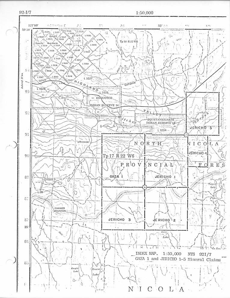
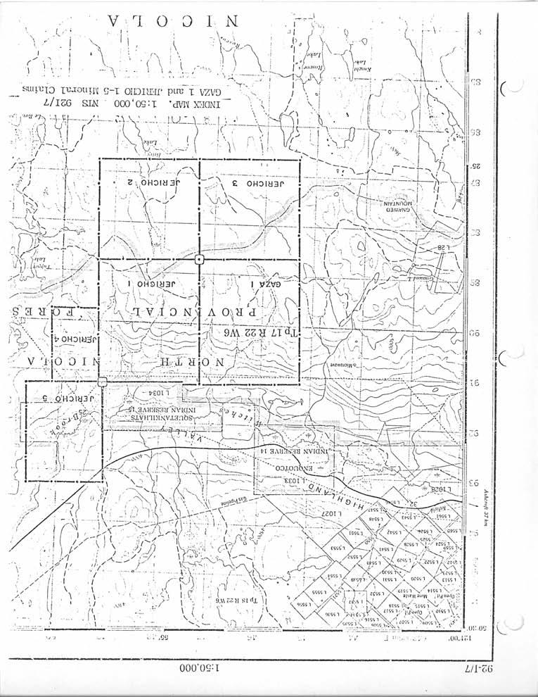
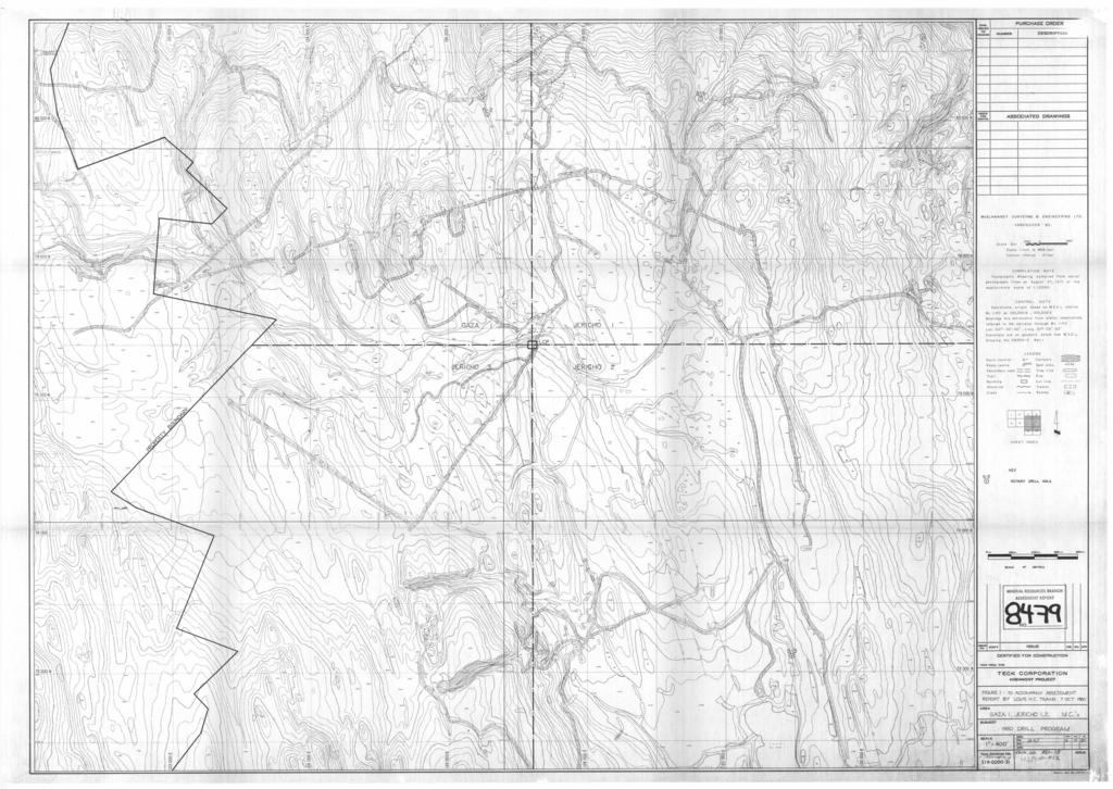
2 Introduction Rotary Drilling Statement of Costs TABLE OF CONTENTS Page No. Apportionment of Cost Author's Certificate Appendix A: Rotary drill hole Logo. LIST OF FIGURES Index Map Figure 1: Rotary drill holes on Gaza 1 and Jericho 1 & 2 mineral claims - After Page 1 - In Pocket
3 Introduction The Gaza and Jericho mineral claims are located in the eastern part of the Highland Valley at elevations from 1150 to 1585 metres above sea level. Access to the claim is by the Ashcroft to Logan Lake paved highway which crosses the northwest corner of the Jericho 5 mineral claim approximately 7 km west of Logan Lake (see index map). The Gaza 1 mineral claim was located by A. J. Reed, agent for Gaza Mines Ltd. on December 12th, The Jericho 1 mineral claim was located by A. J. Reed, agent for New Jericho Development Corporation on September 8th, The Jericho 2 mineral claim was located by A. J. Reed, agent for New Jericho Development Corporation on December 12th, A small bornite-chalcopyrite orebody on the Jericho 1 mineral claim has been explored by percussion drilling, diamond drilling and by two adits indicating reserves of approximately 75,000 tonnes at an average grade of 1.17% copper. During the period August 6th, 1980 to August 16th, 1980, Highmont paid for the following exploration and development to be done. 1) 13.7 metres of 6 diameter rotary drilling on Gaza 1 claim. 2) 3) 25.9 metres of 6 diameter rotary drilling on Jericho 1 claim metres of 6 diameter rotary drilling on Jericho 2 claim.
4
5 Page 2 Rotary Drilling 56.4 metres of 6" diameter vertical holes were drilled on the Gaza 1 and Jericho 1 and 2 mineral claims to test the character of the bedrock adjacent to the tailings pond area. No significant mineralization was encountered with this program. These holes will be used as monitoring holes of the seepage from the tailings pond.
6 Page 3 Statement of Costs 1. WAGES FOR HIGHMONT EMPLOYEES. (a) Tsang, Louis H. C. /I , Tranquille Road Kamloops, B. C. V2B 3L4 Chief Geologist: $110.00/day (August 6-16) 2 days - total cost $ (b) Porter, Merlin Post Office Box 144 Savona, B. C. VOK 250 Drilling Supervisor: $92.00/day (August 6-16) 6 days - total cost $ FOOD AND ACCOMMODATION FOR DRILLER & HELPER OF A & H CONSTRUCTION LTD. (a) Ian McDonald 3 $14./day - total cost (b) Mike McDonald 3 $14./day - total cost $ $ TRANSPORTATION. Geologist's truck used: $12.00/day 1 day - total cost Drilling Supervisor's truck used: $12.0O/day 8 days - total cost $ $ SURVEYING COST FOR DRILL HOLES. (a) Nickerson, Gordon Box 622 Logan Lake, B.C. VOK 1WO Chief Surveyor: $12.00/hour 1 hour - total cost $ 12.00
7 Page 4 (b) Kirkpatrick, Greg 2911 Bank Road Kamloops, B. C. V2B 6Y6 Surveyor: $ll.oo/hour 6 hours - total cost $ (c) Wager, A1 General Delivery Logan Lake, B.C. VOK 1WO Surveyor s helper: $lo.oo/hour 6 hours - total cost $ ANALYSIS COST. Highmont Laboratory: 21 $lo./sample Total Cost $ DRILL SITE PREPARATION. By the Cat unit of Pooley Construction (Merritt, B. C.) (July 28 - August 11, 1980) 3 days - total cost $3, AIR ROTARY DRILLING CONTRACT COSTS. A & H Drillers Ltd Salton Road, P.O. Box 38 Abbotsford, B. C metres of drilling - total cost $6, PREPARATION OF REPORT. Total Cost $ TOTAL $11,991.75
8 Page 5 APPORTIONMENT OF COST 1. TO GAZA /56.4 of rotary drilling (item 7) $1, /56.4 of rotary drilling direct costs (item 1, 2, 3, 5) $ /3 of surveying and site preparation costs (item 4 & 6) $1, /3 cost of report preparation (item 8) $ $3, TO JERICHO 1. (a) 25.9/56.4 of rotary drilling (item 7) (b) 25.9/56.4 of rotary drilling direct costs (item 1, 2, 3, 5) (c) 1/3 of surveying and site preparation costs (item 4 & 6) (d) 1/3 cost of report preparation (item 8) $3, $ $1, $ $5, TO JERICHO 2. (a) 16.8/56.4 of rotary drilling (item 7) (b) 16.8/56.4 of rotary drilling direct costs (item 1, 2, 3, 5) (c) 1/3 of surveying and site preparation costs (item 4 & 6) (d) 1/3 cost of report preparation (item 8) $2, $ $1, $ $3,713.85
9 Page 6 Author's Certificate I, Louis Tsang, of the City of Kamloops, British Columbia, do hereby certify that: I am a member of the Geological Association of Canada. I am a graduate of the University of British Columbia with a B. Sc. degree (1972) in geology and geophysics. I have practiced my profession since 1972 while employed by Bacon & Crowhurst Consulting Engineering Ltd. (one summer season), and by Zapata-Granby Corporation, Granisle Division (seven years). Present, I am employed by Highmont Operating Corporation Ltd., Post Office Box 300, Logan Lake, B. C. I have examined and logged all the cuttings from rotary drill holes S1 to S3 at the Highmont mine site. Louis H. C. Tsang Chief Geologist of Highmont Operating Corporation
10 APPENDIX A: ROTARY DRILL HOLE LOGS
11 DRILLING RECORD Hole No. Sample No. *Hole Depth *Collar Elevation *Remarks R. D. H. - S O/R R. D. H. - S O/B R. D. H. - S O/B * Units in metres
12 LEGEND 6 CODING USED FOR LOGGING CUTTING Legend s= (5%,/mineral present A= 5-10% * mineral significant H= >lo% ",. mineral very significant a.. L lightly altered M medium alteration I intensely altered CODING.".t,E..W

13 BOREHOLE CUTTING LOG..., ;, ;..._L
14 APPENDIX B: ROTARY DRILL HOLE ASSAYS
15 II ICIINONT OFLP,ITI::G COIWI:,I~LON P.O. Box 3000 LOCzIN LAKE, B. C. V0K lij0 Tel: (604) Telex: TO: -- LOUIS TSANG CERTIFICiYrE OF ANALYSIS DATE: August 22, 1980 NO: 0001 RDH s TR ~ 7 i TR TR t i RDH s-2 c RDH 5-3
16
17
7 miles West of Kamloops, B.C.
 MINERAL RESOURCES BRANCH ASSEWAENT RiPORT of hole # 78-11 NO. drilled on the ZZ # 18 Claim of China Commercial Corporation Ltd situated 7 miles West of Kamloops, B.C. in the Kamloops Mining Division D.R.
TABLE OF CONTENTS. Page
 TABLE OF CONTENTS Page GEOCHEMICAL REPORT ON THE GAZA 1, GAZA 2 and JERICHO 1 MINERAL CLAIMS 1. INTRODUCTION (i) Location and Access The Gaza - Jericho property is located approximately 58 kilometers
GEOLOGICAL MAPPING REPORT ON THE ASH MINERAL CLAIM OSOYOOS MINING DIVISION ASHNOLA RIVER MAP SHEET NTS M092,H019 MCBRIDE CREEK AREA, ASHNOLA RIVER,
 GEOLOGICAL MAPPING REPORT ON THE ASH MINERAL CLAIM OSOYOOS MINING DIVISION ASHNOLA RIVER MAP SHEET NTS M092,H019 LATITUDE 49 o O6, LONGITUDE 120 o 22 MCBRIDE CREEK AREA, ASHNOLA RIVER, KEREMEOS, B.C. CANADA
GEOPHYSICAL REPORT CHU CHUA PROJECT Green Mountain Group. KAMLOOPS MINING DIVISION NTS 92P/8E, 82M/5W Lat: 51'24' N Long: 120'00' w
 I GEOPHYSICAL REPORT CHU CHUA PROJECT Green Mountain Group KAMLOOPS MINING DIVISION NTS 92P/8E, 82M/5W Lat: 51'24' N Long: 120'00' w I rvm #.,_..._..._._._.- $...-...! 1 VANCOUVER, B.C. 1 G E 0 I, 0.G
2013 GEOLOGICAL ASSESSMENT REPORT SHERIDAN HILL PROPERTY
 2013 GEOLOGICAL ASSESSMENT REPORT ON THE SHERIDAN HILL PROPERTY NEW WESTMINSTER MINING DIVISION BRITISH COLUMBIA NTS 092G07 49 16 31 NORTH LATITUDE, 122 39 48 WEST LONGITUDE PREPARED FOR Sheridan Hill
GEOLOGICAL BRANCH ASSESSMENT REPORT
 DIAMOND DRILLING REPORT ON THE ROSCOE 1 MINERAL CLAIM RECORD NUMBER 440 IAMLOOPS MINING DIVISION NTS SHEET 921/7 LATITUDE 50~23 'N LONGITUDE 120~58' w OWNED BY NATIONAL TRUST COMPANY LIMITED 510 BURRARD,
cpw 6. E. Spencer Engineering Ltd. HANNA 9 M. C. 104 REP 0 RT DIAMOND DRILLING PROGRAMME LIARD MINING DISTRICT, K.T.S. FOR TAURUS RESOURCES LTD.
 6. E. Spencer Engineering Ltd. LlJ REP 0 RT ON DAMOND DRLLNG PROGRAMME cpw HANNA 9 M. C. LARD MNNG DSTRCT, K.T.S. 104 P@g FOR TAURUS RESOURCES LTD. BY B. E. SPENCER, P. ENG. B. E. SPENCER ENGNEERNG LTD.
NTS 93L/9W GEOCHEMICAL AND GEOPHYSICAL REPORT MONA CLAIM OMINICA MINING DIVISION. Lati tude 54036'N; Longitude 'W
 GEOCHEMICAL AND GEOPHYSICAL REPORT ON MONA CLAIM OMINICA MINING DIVISION Lati tude 54036'N; Longitude 126018'W NTS 93L/9W April 1981 Paul Plicka Consulting Geologist LOCATION MAP INTRODUCTION TABLE OF
TOPOGRAPHICAL SURVEY REPORT ON THE GREENDROP PROPERTY NEAR CHILLIWACK, B.C. 92-H-3/W
 TOPOGRAPHICAL SURVEY REPORT ON THE GREENDROP PROPERTY NEW WESTMINSTER M.D. NEAR CHILLIWACK, B.C. 92-H-3/W Location: The central pap of the claims is located at coordinates 49 08'N, latitude by 121 26'W,
1 CLAIMS GEOPHYSICAL REPORT ON BOYAL SITUATE NORTHEAST OF TILLICUM MOUNTAIN GOLD AREA BURTON - NAKUSP SIQCAEJ MINING DIVISION
 GEOPHYSICAL REPORT ON BOYAL 1 CLAIMS SITUATE NORTHEAST OF TILLICUM MOUNTAIN GOLD AREA BURTON - NAKUSP SIQCAEJ MINING DIVISION CONSULTING GEOLOGIST AUGUST 1983 VANCOUVER B *C INDEX INTRODUCTION ooa,.eoaaa.aaaoaaooaoa~ao~o
for the Greenwood Mining Division, B.C. NTS 82E/7W Latitude 49' 27' W, Longitude 118' 5 Prepared by a= D. Dylan Watt, B.Sc.
 t. b LOGnO: 37~ -08 m. ACTIO#: for the AMP AMP 2 AMP 3 t AMP 4 CLAIMS Greenwood Mining Division, B.C. NTS 82E/7W Latitude 49' 27' W, Longitude 8' 5 %E c,w zc *& a w Prepared by a= -4c. D. Dylan Watt, B.Sc.
PHYSICAL WORK REPORT. the BAY CLAIMS. Omineca Mining Division Smithers, British Columbia N.T.S. 93E 13E/W
 PHYSICAL WORK REPORT the BAY CLAIMS Omineca Mining Division Smithers, British Columbia a N.T.S. 93E 13E/W LATITUDE: 53 57 00 N I LONGITUDE: 127 45 OO W for Home Ventures Ltd. 1201-675 West Hastings Street
UNION MINIERE EXPLORATIONS AND MINING CORPORATION LIMITED ASSESSMENT REPORT ON FITINAT MINERAL CLAIM. Alberni Mining Division Record No.
 M F )( UNION MINIERE EXPLORATIONS AND MINING CORPORATION LIMITED Suite 200, 4299 Canada Way, Burnaby, B.C. V5G 1 H4 Telephone (604) 437-9491 ASSESSMENT REPORT ON GEOCHEMICAL SOIL SURVEYS AND ROCKSAMPLING
t+o...&zz!. ASSESSMENT REPORT Department of Miner and Petroleum Resources MAP.,- INDUCED POLAKIZATION SURVEY OVER THE BROOKS PROSPECT
 5873 INDUCED POLAKIZATION SURVEY OVER THE BROOKS PROSPECT BROOKS PENINSULA AREA VANCOUVER ISLAND, B.C. NANAIMO AND ALBERNI MINING DIVISIONS BY Z. B. DOBORZYNSKI JANUARY, 1976 Department of Miner and Petroleum
SOIL GEOCHEMISTRY. OK-ll AND OK-Ill MINERAL CLAIMS MOUNT THOEN AREA OMINECA MINING DIVISION, B.C. NTS 93 MI6 E & 7 W
 SOIL GEOCHEMISTRY OK-ll AND OK-Ill MINERAL CLAIMS MOUNT THOEN AREA OMINECA MINING DIVISION, B.C. NTS 93 MI6 E & 7 W LATITUDE 55O23'N, LONGITUDE 127 01W Locke B. Goldsmith, P.Eng. Consulting Geologist December
BALFOUR MINING LTD. (N.P.L.) HAM GROUP 92-P-6, CLINTON M. D.8 B. C. Lat 51 17'N, GEOCHEMICAL REPORT. V. CUKOR, P. Eng.
 HAM GROUP 92-P-6, CLINTON M. D.8 B. C. Lat 51 17'N, GEOCHEMICAL REPORT. V. CUKOR, P. Eng.") 34q '7 BALFOUR MINING LTD. (N.P.L.) HAM GROUP 92-P-6, CLINTON M. D.8 B. C. Lat 51 17'N, Long 12lo14'W GEOCHEMICAL REPORT, V. CUKOR, P. Eng. January 31, 1972 TABLE OF CONTENTS 1. INTRODUCTION 2. PROPERTY,
34q '7 BALFOUR MINING LTD. (N.P.L.) HAM GROUP 92-P-6, CLINTON M. D.8 B. C. Lat 51 17'N, Long 12lo14'W GEOCHEMICAL REPORT, V. CUKOR, P. Eng. January 31, 1972 TABLE OF CONTENTS 1. INTRODUCTION 2. PROPERTY,
..!I AXE CLAIMS ON THE. for RICHCORE EXPLORATIONS LTO. GREENWOOD MINING DIVISION BRITISH COLUMBIA. Latitude 49O 30"; Longitude 118' 30'W NTS 82E/9W
 ON THE AXE CLAIMS for RICHCORE EXPLORATIONS LTO. GREENWOOD MINING DIVISION BRITISH COLUMBIA Latitude 49O 30"; Longitude 118' 30'W NTS 82E/9W... -... ~ i.,...._.'..!i Vancouver, B.C. September, 1980 P.
on the Diamond Drilling done on the LAKESIOE GROUP of Mineral Claims SLOCAN MINING DIVISION 82-F-14-W Long ' Lat '
 Assessment Work Report on the Diamond Drilling done on the LAKESIOE GROUP of Mineral Claims SLOCAN MINING DIVISION 82-F-14-W Long 117 22' Lat. 49 58' ADRIAN KESLER SILVERTON, B.C. operator LEVON RESOURCES
THE PROPERTIES of. JSR1CH0 HIKES LTD. and GAZA MIH1SS LTD, HIGHLAND VALLiSY, BRITISH COLUMBIA. for ALWIN MINING COMPAKY LTD.
 BACON & CROWHURST LTD. on THE PROPERTIES of JSR1CH0 HIKES LTD. and GAZA MIH1SS LTD, HIGHLAND VALLiSY, BRITISH COLUMBIA for ALWIN MINING COMPAKY LTD. by R.W. PHENULER, B.Sc., P.Eng. Vancouver, B.C July
RECONNAISSANCE GEOCHEMICAL SURVEY
 RECONNAISSANCE GEOCHEMICAL SURVEY LEGAL, RITA, LOUISE FR. (CHAPLEAU GROUP) REVERTED CROWN GRANTS CHAPLEAU CREEK AREAJ, SLOC& MINING DIVISION 82 F/11W Lat: 49'44" Long: 117"22'W MINERAL RESOURCES BRANCH
PERCY CONTRACTING SERVICES LTD.
 GEOLOGICAL REPORT ON TEN PLACER LEASES (3139, 3140, 3141, 3142, 3143, 3144, 3145, 3146, 3147, 3148) MOREHEAD CREEK CARIB00 MINING DIVISION, B.C. 938/12W (52 38 N, 121 47 W) For PERCY CONTRACTING SERVICES
lat ' N Long ' W
 305 7 ec1;, REPORT ON THE JERY CLAIMS OF POLA RESOURCES LTD. NTS 93L/16 0 0 lat. 54 45' N Long. 126 22' W BABIXE LAKE AREA OMINECA MINING DIVISION, B.C. PAUL PLICKA CONSULTING GEOLOGIST DECEMBER 30, 1981
PROSPECTING REPORT THE WALLACE CLAIM OMENICA MINING DIVISION. 54" x6" 3.d d. for. Reako Exlorat ions Ltd. Wallace Rev. C.G.
 PROSPECTING REPORT ON THE WALLACE CLAIM OMENICA MINING DIVISION 54"44 14 1x6" 3.d d by David A. Howard P.Eng. for Reako Exlorat ions Ltd. Claim Locat ion Wallace Rev. C.G. #1560 Dome Mountain Area 9 3
Date Submitted: June General Nature of Report: Examination of Placer Samples
 General Nature of Report: Examination of Placer Samples Claim: Gold Channel, Record Number 3775!8 1 (Gold Channel Placer Property) Mining Division: Cariboo NTS 093 G 09 W and E Latitude 520 23 N' Longitude1210
58 l'gr'n 'E. Date: January 23, 1979 ASSESSMENT REPORT PLACER SAMPLING & JADE BOULDER EVALUATION PLACER LEASE Liard Mining Divison 1041/7E
 ASSESSMENT REPORT PLACER SAMPLING & JADE BOULDER EVALUATION PLACER LEASE 1711 Liard Mining Divison 1041/7E 58 l'gr'n 18 38'E Owner & operator: Cry Lake Jade Mines Ltd. Author: A.M. Homenuke, P.Eng. Date:
DIANOND DRILLING REPORT. NICOLA MINING DIVISION, B.C. Lat 'N, Long. 12O03O'W N.T.S. Map 921/1 W82E. for
 W DIANOND DRILLING REPORT MM #1, MM #2, MM #3, INEZ #1, INEZ #2, AND CROWN GRANTED CLAIMS NICOLA MINING DIVISION, B.C. Lat. 50 10'N, Long. 12O03O'W N.T.S. Map 921/1 W82E for FLAIR RESOURCES LTD. 1417-409
PRECIOUS METALS. owner. JMT Services Corp. GEOCHPlICAL SAMPLING CHELASLIE WCE, NORTH CENTRAL, B.C. OMINECA MINING DIVISION NTS 93F/5E & 6W
 PRECIOUS METALS REPORT ON 1980 RECONNAISSANCE GEOCHPlICAL SAMPLING CHELASLIE WCE, NORTH CENTRAL, B.C. OMINECA MINING DIVISION NTS 93F/5E & 6W LATITUDE 53O28 N LONGITUDE 125O31 W DATES Qp WORK: JULY 10
Reconnaissance. Of the. Denis mineral claims. Situated at Kilometer 844 of the Alaska Highway. Liard Mining Division. Northeastern British Columbia
 Reconnaissance Of the Denis mineral claims Situated at Kilometer 844 of the Alaska Highway Liard Mining Division Northeastern British Columbia N.T.S. 94M.075 Latitude 59 42 25 Longitude 127 13 12 Field
OSOYOOS UINING DIVISION. 49% - 20' North Latitude 120% - 05' West Longitude. GOOD HOPE RESOURCES LTD West Hastings Street Vancouver, B. C.
 REPORT ON HORSEFLY PROPERTY DIAMOND DRILLING - 1982 OSOYOOS UINING DIVISION 49% - 20' North Latitude 120% - 05' West Longitude 9 x It/YG FOR GOOD HOPE RESOURCES LTD. 1518-1177 West Hastings Street Vancouver,
Gold Mountain Group Gold Mtn. A, B, C & D Mineral Claims Record Nos. 697, 698, 699 & 700. Island Mountain Cariboo Mining Division British Columbia
 GOLD POINT RESOURCES LTD. Geophysical Survey Gold Mountain Group Gold Mtn. A, B, C & D Mineral Claims Record Nos. 697, 698, 699 & 700 Island Mountain Cariboo Mining Division British Columbia Vancouver,
Daiwan Engineering Ltd Granville strees V.ncouver, B. C. cuudr WY 1GS. M e : (604) PROSPECTING REPORT ON THE KING MINERAL CLAIMS
 PROSPECTING REPORT ON THE KING MINERAL CLAIMS") 1030-609 Granville strees V.ncouver, B. C. cuudr WY 1GS M e : (604) 688-1508 PROSPECTING REPORT ON THE KING MINERAL CLAIMS NORTH VANCOUVER ISLAND, BRITISH COLUMBIA NTS: 92Lj13E Latitude: 50" 47' Longitude:
1030-609 Granville strees V.ncouver, B. C. cuudr WY 1GS M e : (604) 688-1508 PROSPECTING REPORT ON THE KING MINERAL CLAIMS NORTH VANCOUVER ISLAND, BRITISH COLUMBIA NTS: 92Lj13E Latitude: 50" 47' Longitude:
VLF and GRADIOMETER SURVEY OVER THE CAT GROUP, INVERMERE AREA GOLDEN MINING DIVISION, BRITISH COLUMBIA NTS 82K/O8W LAT/LONG 50 29' ' FOR
 VLF and GRADIOMETER SURVEY OVER THE CAT GROUP, INVERMERE AREA GOLDEN MINING DIVISION, BRITISH COLUMBIA NTS 82K/O8W LAT/LONG 50 29' - 116 15' FOR W. POCHYLKO STETTLER, ALBERTA BY T.R.B. DUNDAS ISOGEOS EXPLORATION
compietea since tnat date, and wnicn comprisea btage I ot tne recommended
 compietea since tnat date, and wnicn comprisea btage I ot tne recommended four-stage program. GEOLOGY & MINERALIZATION The property situate6 on the southeast slope of Nickel Plate Mtn., and within the
CANEX. PLACEE LIMITE-D
 P- CANEX. PLACEE LIMITE-D EhTDA KO MINES D IWSI OiV PHONE: FRASER LA'KE 699-6211 ENDAKO, B.C. CANADA VOJ ILO PERCUSSION DRILLING REPORT FOR NU. 2 GROUP OF MINERAL CLAINS CANEX PLACER LIMITED ENDAKO MINES
UNION MINIERE EXPLORATIONS AND MINING CORPORATION LIMITED 1 GROUP OF MINERAL CLAIMS. Liard Mining Division, British Columbia
 UNION MINIERE EXPLORATIONS AND MINING CORPORATION LIMITED SUITE 200-4299 CANADA WAY BURNABY. RC. V5G 1 H4 TELEPHONE 437-949 1 - Z ASSESSMENT REPORT ON DIAMOND DRILLING ON THE CLAW NO. 1 GROUP OF MINERAL
CONSULTING GEOLOGICAL 8: MINING ENGINEERS STINGS STREET DA V6E 2E9 GEOPHYSICAL SURVEY SILVER QUEEN 2 ZEBALLOS AREA. B.C.
 DOLMAGE CAMPBELL & ASSOCIATES (1 975) LTD. CONSULTING GEOLOGICAL 8: MINING ENGINEERS STINGS STREET DA V6E 2E9 '' 1E O L 0 G I C A.L B'x;&a:f2:#& 'SESSMENT REPObT 12, Assessment RESOURCES LTD. 111 ReDort
COMINCO LTD. HORIZONTAL LOOP EM AND MAGNETIC SURVEYS ON SHA. CLAIMS 1, 2, 7 and 8 NELSON AND FORT STEELE MINING DIVISIONS, B.C.
 COMINCO LTD. EXPLORATION WESTERN DISTRICT NTS: 82-F/1 HORIZONTAL LOOP EM AND MAGNETIC SURVEYS ON SHA CLAIMS 1, 2, 7 and 8 - ASSESSMENT REPORT - NELSON AND FORT STEELE MINING DIVISIONS, B.C. Latitude Longitude
ANTLER GOLD DRILLS GRAMS PER TONNE GOLD OVER 5.35 METRES AT THE WILDING LAKE GOLD PROJECT, NEWFOUNDLAND
 ANTLER GOLD DRILLS 10.01 GRAMS PER TONNE GOLD OVER 5.35 METRES AT THE WILDING LAKE GOLD PROJECT, NEWFOUNDLAND HALIFAX, NOVA SCOTIA (CNW December 13 th, 2017) Antler Gold Inc. ( Antler ) (TSX- V:ANTL) is
We are committed to providing accessible customer service. If you need accessible formats or communications supports, please contact us.
 We are committed to providing accessible customer service. If you need accessible formats or communications supports, please contact us. Nous tenons à améliorer l accessibilité des services à la clientèle.
GEOLOGICAL MAPPING OF SKARNS ON THE SHEEP AND EWE CLAIMS, TURNAGAIN RIVER, B.C. DURING THE 1979 SUMMER SEASON
 GEOLOGICAL MAPPING OF SKARNS ON THE SHEEP AND EWE CLAIMS, TURNAGAIN RIVER, B.C. DURING THE 1979 SUMMER SEASON CLAIMS: Sheep 1 to 4 Ewe 1, 3, 4 to 8 Lamb 12 Fraction Liard Mining Division, B.C. NTS 104
July Exploring for Canadian Gold in the Rainy River District of Ontario
 July 2013 Exploring for Canadian Gold in the Rainy River District of Ontario 1 Forward Looking Statements Some of the statements in this document may be deemed to be "forward-looking statements". All statements
DEVELOPMENT REPORT. Lone I Mineral Claim Group. Wild Horse River Area Cranbrook, B.C.
 DEVELOPMENT REPORT Lone I Mineral Claim Group Wild Horse River Area Cranbrook, B.C. Fort Steele Mining District NTS 82G/12E 49 38 35 Latitude 115 38 00 Longitude LONE PEAK PLACER LTD. 514-13th Avenue South
MOAG Copper Gold Resources Inc. World Class Moly Opportunity
 World Class Moly Opportunity MOAG has two large exploration projects with a land base of over 135 square kilometres in politically stable mine friendly jurisdictions, British Columbia, Canada and Ireland.
ASSESSMENT REPORT TITLE PAGE AND SUMMARY
 ASSESSMENT REPORT TITLE PAGE AND SUMMARY TITLE OF REPORT: 2016 Prospecting Report Sphynx Claim TOTAL COST: $167.56 AUTHOR(S): Giacomo Grassi SIGNATURE(S): NOTICE OF WORK PERMIT NUMBER(S)/DATE(S): STATEMENT
Geo chemi c a1 Rep or t SILVER KING FAST GROUP. H. S. Lazenby Geologist. Vancouver, B.C. 16 November 1967
 Geo chemi c a1 Rep or t on SILVER KING FAST GROUP 1967 Vancouver, B.C. 16 November 1967 H. S. Lazenby Geologist Contents Introduction P. 1 Method of Survey P. 1 Interpretation of Results p. L&2 Statement
for the Greenwood Mining Division, B.C. NTS 82E/7W 29' W, Longitude 118' 53' N Prepared by D. Dylan Watt, B.Sc.
 for the FltE NO: u VOLT 1, VOLT 2, VOLT 3, & VOLT 4 CLAIMS Greenwood Mining Division, B.C. NTS 82E/7W Latitude 49' 29' W, Longitude 118' 53' N Prepared by D. Dylan Watt, B.Sc. #309-1996 Trutch Street Vancouver,
3 I1 I I Ill 111 II! II 111 II Ill I IlE I I P I
 -7 3 1 1 11111111111111111111111111111111 ll 111! 111 111 111 111 111111111111111 ll 1111111 1 11111111111111 le P GEOCHEMCAL SURVEY OF THE KE AND D'ARCY CLAM GROUPS.. Similkameen Mining Division, B.C.
Carrapateena Mineral Resources Explanatory Notes April OZ Minerals Limited. Carrapateena Mineral Resources Statement April
 OZ Minerals Limited Carrapateena Mineral Resources Statement April 14 2011 CARRAPATEENA MINERAL RESOURCE STATEMENT April 14, 2011 The Carrapateena Resource Statement relates to an upgrading to an Inferred
ASSESSMENT REPORT ON THE PEAVINE PROJECT. DGW & Associates # Alberni Street, Vancouver, British Columbia, V6E 4V2
 ASSESSMENT REPORT ON THE PEAVINE PROJECT KAMLOOPS MINING DIVISION BRITISH COLUMBIA NTS 082M 12 Latitude 51 36' 19.0"North -- Longitude --119 47' 27.0"West UTM Zone 11, NAD 83 5720827N 306744E Prepared
GEOCSZNICAL - SURVEY. ICAMLOOPS Kl.D. 2'' 6;kr. HY "'f. Alfred R. Allen,P.Eng. 1 NO.%=...,... 6"- 'I.
 t i.i GEOCSZNICAL - SURVEY i p' ICAMLOOPS Kl.D. 2'' 6;kr HY 50-64 +."'f 121-51 NE 5-10-70 : 19-10-70 Alfred R. Allen,P.Eng. I) ' 1 6"- 'I. 1 NO.%=...,..... Q.C. EXPLORATIONS LTD. 2Cl- 535 Kowe Street Vancouver
32?un North of Hope, B.C.,
 Geological Reconnaissance Assessment Report on portions of the Gilt Creek Group (Mike, C.G., Julie, and Gilt Mineral Claims) Situated 32?un North of Hope, B.C., New Westminster Mining Division N 'P 97H/11W
PHOENIX GEOPHYSICS LIMITED REPORT ON THE VLF-EM AND TOTAL FIELD MAGNETOMETER SURVEYS ON THE
 PHOENIX GEOPHYSICS LIMITED REPORT ON THE VLF-EM AND TOTAL FIELD MAGNETOMETER SURVEYS ON THE TAN CLAIMS, CHILLIWACK AREA NEW WESTMINSTER MINING DIVISION, BRITISH COLUMBIA FOR LORNEX MINING CORPORATION LIMITED
41,a* h0.iiii*bll*i2l,i DEADWOOD CREEK. for. James R. on the BOMBINI GROUP OF CLAIMS. GREENWOOD, British Columbia. Lat. 49'07' Long. 118'43 f.
 GEOLOGCAL REPORT on the BOMBN GROUP OF CLAMS DEADWOOD CREEK GREENWOOD, British Columbia Lat. 49'07' Long. 118'43 f in the GREENWOOD MNNG DVSON for FURY EXPLORATONS LTD. (N. P. L. ) Vancouver, B. C. December
HOWE COPPER MINE PROJECT HIGH GRADE Cu-Ag with Au
 HOWE COPPER MINE PROJECT HIGH GRADE Cu-Ag with Au The Howe Copper Mine property is located approximately 55 kilometres northwest of Vancouver, BC. It is situated at 1431 metres elevation on the eastern
REPORT ON ON THE. ALAMO 1 AND 2 CLAIMS Record Nos: 784(4) - 785(4) KAMLOOPS MINING DMSION LONG. 120'59'
 - 785(4) KAMLOOPS MINING DMSION LONG. 120'59'") REPORT ON BIOGEOCHEMICAL SURVEY AND LINECUTTING ON THE ALAMO 1 AND 2 CLAIMS Record Nos: 784(4) - 785(4) KAMLOOPS MINING DMSION N.T.S. LAT. 50 22', 92U7W LONG. 120'59', Owner: H. H. Shear 580-625 Howe Street
REPORT ON BIOGEOCHEMICAL SURVEY AND LINECUTTING ON THE ALAMO 1 AND 2 CLAIMS Record Nos: 784(4) - 785(4) KAMLOOPS MINING DMSION N.T.S. LAT. 50 22', 92U7W LONG. 120'59', Owner: H. H. Shear 580-625 Howe Street
ASSESSMENT REPORT I.P./RESISTIVITY AND MAGNETICS SURVEY ON THE HAUTETE PROPERTY LATITUDE: 55O 12' N LONGITUDE: 126O 07' W
 NTS: 93W1 ASSESSMENT REPORT I.P./RESISTIVITY AND MAGNETICS SURVEY ON THE HAUTETE PROPERTY LATITUDE: 55O 12' N LONGITUDE: 126O 07' W OMINECA MINING DISTRICI'. B.C. CLAIMS COVERED : TET 1-8 TIME PERIOD:
BALTO RESOURCES LTD. (Owner & Operator) GEOPHYSICAL ASSESSMENT REPORT. (Event Number ) on the SED MINERAL CLAIM.
 GEOPHYSICAL ASSESSMENT REPORT. (Event Number ) on the SED MINERAL CLAIM.") BALTO RESOURCES LTD. (Owner & Operator) GEOPHYSICAL ASSESSMENT REPORT (Event Number 5173274) on the SED MINERAL CLAIM (Tenure 392163) Kamloops Mining Division NTS 092I.047 Centre of Work 5589550N, 667600E
BALTO RESOURCES LTD. (Owner & Operator) GEOPHYSICAL ASSESSMENT REPORT (Event Number 5173274) on the SED MINERAL CLAIM (Tenure 392163) Kamloops Mining Division NTS 092I.047 Centre of Work 5589550N, 667600E
PIOTR LUTYNSKI VANCOUVER, BRITISH COLUMBIA
 AN ASSESSMENT REPORT ON GROUND MAGNETIC SURVEYING CHUCHI PROPERTY FORT ST. JAMES AREA, BRITISH COLUMBIA OMINECA M.D. 55 17 N, 124 31 W NTS 93N/ 7&8 Claims Surveyed: 597976, 597878-597880 Survey Dates:
NEW HAZELTON, OMINECA M.D.,
 PROSPECTING REPORT JUDI 1 TO 6 MINERAL CLAIMS NEW HAZELTON, OMINECA M.D., B.C. MAP 93M/4E, LAT. SS014'N, LONG. 127'33'W OWNED BY: A. L'ORSA ANTHONY L'ORSA Smithers, B.C. 21 February, 1981 TABLE OF CONTENTS
REPORT ON A GEOLOGICAL MAPPING AND PROSPECTING PROGRAM LOOK PROPERTY
 b KOKANEE EXPLORATIONS LTDI I WNO. 0 I- n c/ REPORT ON A GEOLOGICAL MAPPING AND PROSPECTING PROGRAM LOOK PROPERTY LOOK 1-31, 36-43 CLAIMS FORT STEELE MINING DIVISION CRANBROOK AREA N.T.S. 82G/5W + 4E E:
American Creek Resources is a precious metals exploration company with an impressive portfolio of high-potential gold
 American Creek Resources is a precious metals exploration company with an impressive portfolio of high-potential gold and silver projects in British Columbia. These include properties in B.C.'s prolific
April Exploring for Canadian Gold in the Rainy River District of Ontario
 April 2013 Exploring for Canadian Gold in the Rainy River District of Ontario 1 Forward Looking Statements This presentation may contain forward-looking statements including but not limited to comments
n3a 92 C- /.I 4 tr November 6, 1979 J. F. MclNTYRE, P.ENG. CONSU LTlNG MINING ENGl NEER Map #92C-16 TRANS PACIFIC VENTURES LTD.
 TELEPHONE : 5 9 6-1331 J. F. MclNTYRE, P.ENG. CONSU LTlNG MINING ENGl NEER 6466 CAGELDU CRESCENT DELTA, B.C. CANADA TRANS PACIFIC VENTURES LTD. c i. SAMPLING AND GEOPHYSICAL REPORT CAP CLAIM, VICTORIA
OSISKO METALS INTERSECTS 10.49% ZINC+LEAD OVER METRES AND 12.15% ZINC+LEAD OVER METRES AT PINE POINT
 OSISKO METALS INTERSECTS 10.49% ZINC+LEAD OVER 22.84 METRES AND 12.15% ZINC+LEAD OVER 17.00 METRES AT PINE POINT (Montreal November 19, 2018) Osisko Metals Incorporated (the Company or Osisko Metals )
DIAMOND DRILL REPORT ON THE LOCATED IN THE OMINECA MINING DIVISION FAWNIE NOSE AREA LATITUDE: 53O 17' LONGITUDE: 125O 10' NTS 93F 6E
 GRANGES EXPLORATION AB CANADIAN DIVISION DIAMOND DRILL REPORT ON THE G, H and I CLAIM BLOCKS LOCATED IN THE OMINECA MINING DIVISION FAWNIE NOSE AREA LATITUDE: 53O 17' LONGITUDE: 125O 10' NTS 93F 6E. -.
Summary of Rover Metals Geologic Mapping Program at the Up Town Gold Project, Northwest Territories
 October 13, 2017 Summary of Rover Metals Geologic Mapping Program at the Up Town Gold Project, Northwest Territories Vancouver, British Columbia, Canada - Rover Metals Corp., Rover, is pleased to provide
REPORT ON MAGNETOMETER SURVEY TIK-1 CLAIM e&f KAMLOOPS MINING DTVISION. by D. Hendry D. C. MILLER. February 3, for
 REPORT ON MAGNETOMETER SURVEY TIK-1 CLAIM 92-1-14 e&f KAMLOOPS MINING DTVISION lat. 50 57 ' 12" long. 121O23 ' 37" OWNER: ST. JOSEPH EXPLORATIONS LIMITED OPERATIOR: ST. JOSEPH EXPLORATIONS LIMITED by D.
With improved metal prices and utilizing new technology past producing copper gold mines are being re started by new owners
 With improved metal prices and utilizing new technology past producing copper gold mines are being re started by new owners Re starting the Phoenix copper gold mine British Columbia, Canada 1 Overview
PROSPECTORS ASSISTANCE PROGRAM MINISTRY OF ENERGY AND MINES
 BRITISH COLUMBIA PROSPECTORS ASSISTANCE PROGRAM MINISTRY OF ENERGY AND MINES GEOLOGICAL SURVEY BRANCH PROGRAM YEAR: 1999/2000 REPORT #: PAP 99-l 6 NAME: KIM ANSCHETZ PROSPECTORS TlEPORT on the 99 LOUIS
vox 1wo LOG NO: SEP 1 019% RD. &CTlON. JG-1, PILOT GOLD, PILOT GOLD 1 h 2. AND GOLD WING 1 TO 6 CLAIMS for HAROLD ADAMS Box 1329 Princeton, B.C.
 LOG NO: SEP 1 019% RD. &CTlON. JG-1, PLOT GOLD, PLOT GOLD 1 h 2. AND GOLD WNG 1 TO 6 CLAMS r Weyrnan Creek Area Kamloops Mining Division 82L-5W (50O22' N. Lat., 119O59' W. Long.) for HAROLD ADAMS Box 1329
SELF POTENTIAL SURVEY OVER THE JAY GROUP, INVERMERE AREA GOLDEN MINING DIVISION, BFUTISH COLUMBIA NTS 82W8W7 82W9W LATLONG 50 30' ' FOR
 - GEOLOGICAL SURVEY BRANCH ASSESSMENT REPORTS -- -- DATE RECEI?/::D 06T 10 1996 - SELF POTENTIAL SURVEY OVER THE JAY GROUP, INVERMERE AREA GOLDEN MINING DIVISION, BFUTISH COLUMBIA NTS 82W8W7 82W9W LATLONG
J.D. Mason, Prof. Engineer. Report on the Reconnaissance Magnetometer Survey. Completed for. North American Platinum Corporation Ltd.
 Report on the Reconnaissance Magnetometer Survey Completed for North American Platinum Corporation Ltd. Olivine Mountain Property, Tulameen, B.C. J.D. Mason, Prof. Engineer. November 28, 1967. Certificate
EXPLORATION UPDATE: BODDINGTON SOUTH GOLD PROJECT AND DOOLGUNNA STATION PROJECT
 The Manager ASX Company Announcements PO Box H224, Australia Square Sydney NSW 2001 20 September 2010 EXPLORATION UPDATE: BODDINGTON SOUTH GOLD PROJECT AND DOOLGUNNA STATION PROJECT Boddington South Gold
PROSPECTING Survey Over the AULD PROPERTY Auld Township, Ontario
 PO Box 219, 14579 Government Road, Larder Lake, Ontario, P0K 1L0, Canada Phone (705) 643-2345 Fax (705) 643-2191 www.cxsltd.com PROSPECTING Survey Over the AULD PROPERTY C Jason Ploeger, B.Sc, P.Geo August
REPORT ON DIAMOND DRILLING AT THE PROPERTY OF CONSOLIDATED CINOLA MINES LTD. ENERGY RESERVES CANADA (METALS) LTD. NOVEMBER - DECEMBER 1984.
 LTD. NOVEMBER - DECEMBER 1984.") REPORT ON DIAMOND DRILLING AT THE PROPERTY OF CONSOLIDATED CINOLA MINES LTD. ENERGY RESERVES CANADA (METALS) LTD. NOVEMBER - DECEMBER 1984 03/8 ig; CINOLA CLAIM GROUP GRAHAM ISLAND, B.C. SKEENA MINING
REPORT ON DIAMOND DRILLING AT THE PROPERTY OF CONSOLIDATED CINOLA MINES LTD. ENERGY RESERVES CANADA (METALS) LTD. NOVEMBER - DECEMBER 1984 03/8 ig; CINOLA CLAIM GROUP GRAHAM ISLAND, B.C. SKEENA MINING
We are committed to providing accessible customer service. If you need accessible formats or communications supports, please contact us.
 We are committed to providing accessible customer service. If you need accessible formats or communications supports, please contact us. Nous tenons à améliorer l accessibilité des services à la clientèle.
GEOCHEMICAL STREAM SAMPLING. on the PLACER LEASES NO. Jordan River/Bear Creek Area. Victoria Mining Division. Latitude 48 degrees 32 minutes N.T.S.
 GEOCHEMCAL STREAM SAMPLNG on the PLACER LEASES NO P. 8149, 8150, 8151, 8152, 8161, 8162, 8163, 8400, 10844, 10845 Jordan River/Bear Creek Area Victoria Mining Division Latitude 48 degrees 32 minutes Longitude
ASSESSMENT REPORT TITLE PAGE AND SUMMARY
 ASSESSMENT REPORT TITLE PAGE AND SUMMARY TITLE OF REPORT: Assessment Report on Andys Bridge Mineral Claim, Turnagain River Area TOTAL COST: $2,100 AUTHOR(S): Bruce w Downing SIGNATURE(S): Bruce W Downing
Geochemical Assessment Report. on the. Situated Nineteen Kilometres rth-northeast of Hope, B. C. in the. New Westminster Mining Division
 7 I Geochemical Assessment Report r on the r- I 1 Norm 1 to Norm 4 Mineral Claims c - I - 7 Situated Nineteen Kilometres rth-northeast of Hope, B. C. in the New Westminster Mining Division itude 49*32'N.,
Fox 2-Record No. 2524
 F HELICOPTER E.M. AND MAGNETOMETER SURVEY OVER THE FOX CLAIMS, OMINECA MINING DISTRICT BRITISH COLUMBIA ON BEHALF OF OWNER MR. MIKE BOYLE Claims: Fox l-record No. 2523 Fox 2-Record No. 2524 Location 126'
GEOCHEMICAL REPORT ON A SOIL SAMPLING SURVEY OF PORTIONS OF THE KR GROUP OF MINERAL CLAIMS OF PLATEAU METALS LIMITED.
 GEOCHEMICAL REPORT ON A SOIL SAMPLING SURVEY OF PORTIONS OF THE KR GROUP OF MINERAL CLAIMS OF PLATEAU METALS LIMITED By Kol Lovang Christopher Riley, P. Eng., Supervisor c Vancouver, B. c. Work Performed:
North American Palladium Announces Positive Exploration Results from Lac des Iles Mine
 North American Palladium Announces Positive Exploration Results from Lac des Iles Mine Toronto, Ontario, October 24, 2017 North American Palladium Ltd. ( NAP or the Company ) (TSX: PDL) (OTC PINK: PALDF)
ASSESSMENT REPORT. on the REPORT BY. John DeLeen, Consulting Geologist, P.Eng.
 ASSESSMENT REPORT PERCUSSION DRILLING AND SAMPLING on the SKU GROUP OF MINERAL CLAIMS The claims involved are SKU 1-45(11), SKU -46(11), and Good News 74 (1) located in the Kamloops Mining Division and
REPORT ON THE MAGNETOMETER SURVEYOF THE SO0 MINERAL CLAIMS MERRITT, B. C.
 336 REPORT ON THE MAGNETOMETER SURVEYOF THE SO0 MINERAL CLAIMS MERRITT, B. C. To: The Directore Copper Soo Mining Syndicate OSO~OOS, B. C. R. C. Clough hglneering Ltd. Harvey H. Cohen, P. Pmg. TABLE OF
Kiska Metals Corporation Project Updates
 Kiska Metals Corporation Project Updates Minerals North Conference, Mackenzie BC May 28, 2015 Kelly Franz, P.Geo Manager, Lands and Corporate Social Responsibility Cautionary Note This presentation contains
REPORT. on the. Omineca Mining Division, British Columbia. Latitude N., Longitude W. NTS map sheet 93F/7E. James W. McLeod, P.Geo.
 REPORT on the CHU MOLYBDENUM PROPERTY Omineca Mining Division, British Columbia Latitude 53 21 N., Longitude 124 37 W. NTS map sheet 93F/7E James W. McLeod, P.Geo. on behalf of Mr. Chris Delorme TABLE
SAMPLE ID SAMPLE TYPE Au (g/t) Ag (g/t) Cu (%) AuEq**(g/t)
 Ag (g/t) Cu (%) AuEq**(g/t)") GOLDEN RIDGE RESOURCES DISCOVERS NEW ALKALIC CU-AU PORPHYRY TARGET ON ITS HANK PROJECT Kelowna, British Columbia November 22,2017 - Golden Ridge Resources Ltd. ( Golden Ridge or the Company ) (TSXV: GLDN).
GOLDEN RIDGE RESOURCES DISCOVERS NEW ALKALIC CU-AU PORPHYRY TARGET ON ITS HANK PROJECT Kelowna, British Columbia November 22,2017 - Golden Ridge Resources Ltd. ( Golden Ridge or the Company ) (TSXV: GLDN).
Malachite Resources Limited ABN
 Malachite Resources Limited ABN 86 075 63 268 ASX Announcement ASX Code: MAR 27 October 20 NEW DRILLING RESULTS AT LORENA SUPPORT COMMENCEMENT OF MINING FEASIBILITY STUDY Malachite Resources Limited (
A B C PAD A HIGHLIGHTS
 Murchison Minerals Intercepts 12.30% Zinc, 0.70% Copper, 0.18% Lead and 42.03 g/t Silver 14.97% ZnEq over 6.37 Metres and Extends Known Limits of Brabant McKenzie VMS Deposit June 25, 2018 (Toronto, Ontario):
490 20' 30" North Latitude ' 30" West Longitude
 _._.. I CONSULTING GEOLOGISTS 605-602 WEST HASTINGS STREET, VANCOUVER, B.C. V6B 1P2 TELEPHONE: (604) 689-5533 6 I F: ASSESSMENT REPORT ON THE PATSY 1 MINERAL CLAIM ' '?%2% I WHISTLE CREEK, HEDLEY ARE L-l-
REPORT ON DIAMOND DRILLING SUBSTITUTION EAST PROPERTY CLAIMS AND HEBERT TOWNSHIP ONTARIO, CANADA
 REPORT ON DIAMOND DRILLING SUBSTITUTION EAST PROPERTY CLAIMS 1248920 AND 1248921 HEBERT TOWNSHIP ONTARIO, CANADA Adroit Resources Inc. Suite #610-1111 Melville Street Vancouver, British Columbia, Canada
'-7' REPORT ON A MAGNETOMETER SURVEY OVER PART OF THE MAX CLAIM GROUP 1-20 LAC LE JEUNE AREA KAMLOOPS MINING DIVISION KAMLOOPS, BRITISH COLUMBIA
 I,., - SUITE 102. 222 BELLEVUE WES t ANCOUVER, B. '-7' REPORT ON A I MAGNETOMETER SURVEY OVER PART OF THE MAX CLAIM GROUP 1-20 LAC LE JEUNE AREA KAMLOOPS MINING DIVISION KAMLOOPS, BRITISH COLUMBIA 50-30
ASSESSMENT REPORT TITLE PAGE AND SUMMARY
 ASSESSMENT REPORT TITLE PAGE AND SUMMARY TITLE OF REPORT: 2016 Prospecting Report Midas Claim TOTAL COST: $314.61 AUTHOR(S): Giacomo Grassi SIGNATURE(S): NOTICE OF WORK PERMIT NUMBER(S)/DATE(S): STATEMENT
GEOLOGICAL BRANCH ASSESSMENT REPORT 12. FItE NO: ACTION: THE GOLDEN MINING DIVISION, GOLDEN, Including THE NTS MAP; M82K/15W
 ACTION: FItE NO: Including 1990 GEO-CHEM SURVEY RESULTS -- THE AVD CLAIMS - THE GOLDEN MINING DIVISION, GOLDEN, B.C. NTS MAP; M82K/15W Lat. 50 deg. 55 Min. Long 116 deg. 55 min. For GEOLOGICAL BRANCH ASSESSMENT
A REPORT. Bear Lake, British Columbia (56' 13'N, ~) N.T.S. 94 D U& Claims surveyed: BL 1, units 2
 N.T.S. 94 D U& Claims surveyed: BL 1, units 2") I PETER E. WALCOTl' Rr ASSOC. LTD. A REPORT AN INDUCED POLARIZATION SURVEY T.?. d." Bear Lake, British Columbia rnk (56' 13'N, 1270 49~) N.T.S. 94 D U& *o Claims surveyed: BL 1, units 2 *a* & 3 BL 2, units
I PETER E. WALCOTl' Rr ASSOC. LTD. A REPORT AN INDUCED POLARIZATION SURVEY T.?. d." Bear Lake, British Columbia rnk (56' 13'N, 1270 49~) N.T.S. 94 D U& *o Claims surveyed: BL 1, units 2 *a* & 3 BL 2, units
A New Direction. Copper-Gold Deposit at Thor TSX.V:COL. August 11, May 2013
 A New Direction Copper-Gold Deposit at Thor August 11, 2016 May 2013 TSX.V:COL FORWARD LOOKING STATEMENTS This presentation includes certain forward-looking information or forward-looking statements for
TSX.V: TR. Drilling in the Shadow of World-Class Deposits. TR: TSX.V January 2019
 TSX.V: TR Drilling in the Shadow of World-Class Deposits TR: TSX.V January 2019 1 Looking Forward Statement Investors are cautioned that, except for statements of historical fact certain information contained
ASSESSMENT' REPORT GEOPHYSICAL REPORT ON THE ATTORNEY 2 CLAIM (4 UNITS) OMINECA MINING DIVISION SHEILA A. CRAWFORD.
 OMINECA MINING DIVISION SHEILA A. CRAWFORD.") ASSESSMENT' REPORT GEOPHYSICAL REPORT ON THE ATTORNEY 2 CLAIM (4 UNITS) OMINECA MINING DIVISION by SHEILA A. CRAWFORD LOCATION: 57z17' N Latitude 127 11' W Longitude N.T.S. 94E/6E OWNER/OPERATOR: SEREM
ASSESSMENT' REPORT GEOPHYSICAL REPORT ON THE ATTORNEY 2 CLAIM (4 UNITS) OMINECA MINING DIVISION by SHEILA A. CRAWFORD LOCATION: 57z17' N Latitude 127 11' W Longitude N.T.S. 94E/6E OWNER/OPERATOR: SEREM
N.T.S. 092I/07W N, W. On behalf of. DOT Resources Ltd. SUITE TH AVENUE SW CALGARY, ALBERTA T2P 0T8.
 TECHNICAL REPORT ON A MINERAL RESOURCE ESTIMATE FOR DOT RESOURCES LTD. S DOT PROPERTY MERRITT, BRITISH COLUMBIA NICOLA MINING DIVISION N.T.S. 092I/07W 50 19 18 N, 120 50 58 W On behalf of SUITE 330 700-6TH
Serengeti Resources Inc GEOCHEMICAL REPORT ON THE SHADOW PROPERTY a.
 Serengeti Resources Inc. 2004 GEOCHEMICAL REPORT ON THE SHADOW PROPERTY a. Located in the Johanson Lake Area Omenica Mining Division NTS 94D/9 6 degrees and 32 minutes North Latitude 126 degrees and 2