t+o...&zz!. ASSESSMENT REPORT Department of Miner and Petroleum Resources MAP.,- INDUCED POLAKIZATION SURVEY OVER THE BROOKS PROSPECT
|
|
|
- Blake Page
- 5 years ago
- Views:
Transcription
1 5873 INDUCED POLAKIZATION SURVEY OVER THE BROOKS PROSPECT BROOKS PENINSULA AREA VANCOUVER ISLAND, B.C. NANAIMO AND ALBERNI MINING DIVISIONS BY Z. B. DOBORZYNSKI JANUARY, 1976 Department of Miner and Petroleum Resources ASSESSMENT REPORT t+o...&zz!. MAP.,-
2 c TABLE OF CONTENTS SUMMARY AND CONCLUSIONS 1 REASON FOR SURVEY 2 LOCATION AND ACCESS EQUIPMENT AND PROCEDURE RESULTS %, CONCLUSIONS
3 LIST OF ILLUSTRATIONS "' 1. Location Map of Brooks Prospect fj, 2. Claims Surveyed i,; 3. Dipole-Dipole Array & ''1 4. Pseudo Section - Line 28+00S., 0, 5. Pseudo Section - Line 32+00S *' 6. Pseudo Section - Line 36+00S 4 >' 7. Map (In Pocket) - Plan of Induced Polarization Survey # c 8. Location Map - No. 14 dated Jan. 1976
4 SUMMARY AND CONCLUSIONS A variable frequency induced polarization survey was carried out over a claim group southwest of Port Alice on Vancouver Island. One weak response was identified from the survey area. The cause may be an increase in fracturing of the rock. There are no indi- cations of concentrations of disseminated sulphide mineralization in 7 % excess of 2% in the survey area.
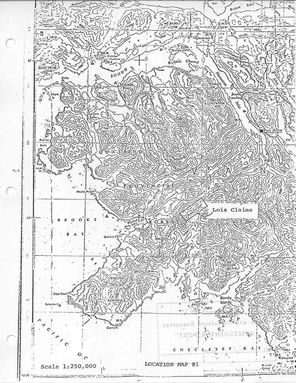
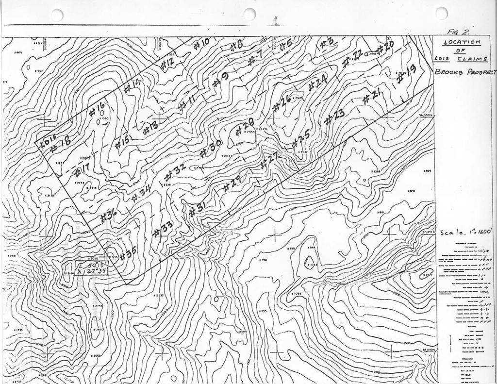
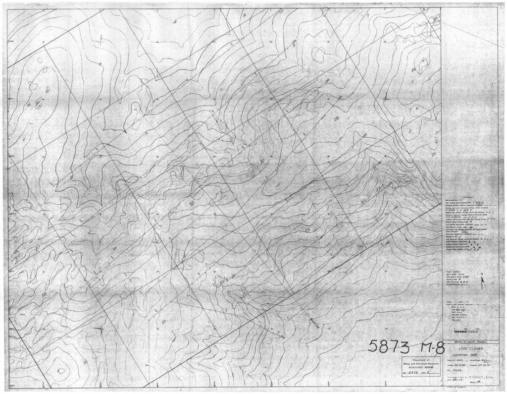
5 - 2 - REASON FOR SURVEY The Brooks prospect is being explored for porphyry copper mineralization. Three lines were surveyed with induced polarization to locate the copper mineralization or the pyrite halo believed to surround it. LOCATION AND ACCESS The property is located about eleven miles southwest of the village of Port Alice on Vancouver Island (Fig. 1). The claims (Fig. 2) 7 s straddle the rounded ridge separating the Little Klaskish river drainage to the north and the Nesparti River. Access to the property is by helicopter, either from the end of the road at Port Alice or from the helicopter charter base at Port Hardy, about 30 miles to the northwest. EQUIPMENT AND PROCEDURE A McPhar P670 variable frequency induced polarization unit was used. The maximum output of the transmitter was 2.5 KW at two frequen- cies: 0.3 and 5.0 Hz. The ground was energized by a pair of stainless steel electrodes, a distance of 200 feet apart. The resulting ground voltages were measured between a second pair of electrodes also 200 feet apart, and an integer number (n) times the electrode separation from the current electrodes. The electrode configuration is called the dipole-
6
7 i -3 3! 8
8 - 5 - dipole array and is illustrated in Fig. 3. The quantities recorded are the apparent resistivity at 0.3 Hz. (Pa/2'ii in ohm-meters) and the Frequency Effect (PFE), which is the percentage change in the resistivities at the two frequencies. Since the degree of polarization is related to the apparent resistivity, it is found that the Metal Factor (MF) is a useful parameter in determining the amount of polarization in a rock mass. This value is obtained by dividing the PFE by the corresponding apparent resistivity at 0.3 Hz. Measurements were taken for 4 values of (n) = 1, 2, 3 and 4, 7 s thereby increasing, in steps, the volume of rock sampled. The data are presented in a pseudo depth section format, illustrated in Fig. 3. It should be noted that the separation between the current and potential electrodes is only factor determining the depth of sampling. Therefore these plots are not true vertical sections of the electrical properties of rock below the survey line. The results are presented at a scale of 1" = 200' in pseudo sections (Figs. 4, 5 and 6) and plan view (Map 1). RESULTS A number of low resistivity zones were detected. Many of these may be caused by topography and/or changes in the level of the water table.
9 1,2-5,6-6 - c METHOO USED IN PLOTTING DIPOLE-DIPOLE INDUCE0 POLARIZATION AND RESISTIVITY RESULTS I 2 3 I I I Stations on line x = Electrode spread length n = Electrode separation n - 4 P P P I,2-6,7. 2,3-7,8 3,4-8,9 n - 3 P P P P 1,2-5,6 2, ,8 4,5-8.9 Apparent Resistivity P P P P P n - 2 1,2-4,5 2,3-5,6 3,4-6,7 4,5-7,8 5,6-8,9 P P P P P P n - J L I a 9 \ / \ / \ / \ / \ / \ ' M.E M.F. M. F. M.E M.F. M. F n - l 1,2-3, ,4-5,6 4,5-6,? 5,6-7, M. F. M.F. M. F. M.F. M.F. n-2 1,2-4,5 22-5,6 3,4-6,7 4,5-7,0 5,6-8,9 M.E M.F M. F. M. F n - 3 ~ n - 4 1,2-6,7 2,3-7,8 3,4-8,9 2,3-6,7 3,4-7,8 4,5-8,9 Apparent Metal Factor M. F. M. F. M. E t I a 9 n - l I,2-3, ,s 3,4-5,6 4,5-6,7 5,6-7,8 6,7-8,9 F. E. F, E. F. L F.E. F. E. n - 2-1,Z-4, ,6 3,4-6,7 4,5-7,8 5,6-8,9 F. E. F. E. F.E. F. E. n - 3 1,2-5,6 2,3-6,7 3,4-7,8 42-8,9 Apparent Percent F. E. F. E. F. E. Frequency Effect n - 4 1,2-6,7 2,3-7,
10 - 7 - The drop in resistivity with depth on line 32+00S between 3+00E and lwooe is more regular in response and may be related to an increase in fracturing. CONCLUSIONS The induced polarization survey did not delineate any zones which can be attributed to concentrations of sulphide mineralization in excess of 2%. The lower resistances with depth on line 32+00S between 3+00E and IWOOE may be caused by an increase in fracturing. Z.B. Doborzynski Geophysicist
11 ASSESSMENT DETAILS PROPERTY Brooks Prospect - Lois Claim Group MINING DIVISION Nanaimo and Alberni LOCATION Port Alice, Vancouver Island, B.C. TYPE OF SURVEY Induced Polarization DATE STARTED July 24, DATE FINISHED August 7, 1975 OPERATING MAN DAYS 90 DRAUGHTING MAN DAYS 2 CONSULTING MAN DAYS 2 FIELD TECHNICIANS G. Dunn $ 50/day F. Shulist $ 50/day HELPERS R. Marguordt D. Bawol G. Wilson R. Simmons CONSULTANT 2. Doborzynski $150/day
12 _ CERTIFICATE I, Zbigniew B. Doborzynski, of the City of Toronto, in the Province of Ontario, hereby certify: 1. I am a geophysicist with a business address at 1235 Bay St., Toronto, Ontario I have been ernployed as a geophysicist for 2 years. I am a graduate of McGill University with a B. Eng. (1971) in Mining Engineering and Applied Geophysics and an M. Sc. (1974) in Applied Geophysics. I am an associate member of the Society of Exploration Geophysicist. The statements made in this report are based on a study of unpublished geological Z.B. Doborzynski Dated - February 4, 1976
13 ~~ COST STATEMENT FOR INDUCED POLARIZATION SURVEY LOIS 1-36 MINERAL CLAIMS VANCOUVER ISLAND, B.C. NANAIMO & ALBERNI MINING DIVISIONS Dane A. Bridge June, 1976 Department of Miner and Petroleum Resources ASSESSMENT REPORT
14 INTRODUCTION This cost statement for assessment work is to accompany a report titled: Induced Polarization Survey over the Brooks Penninsula Area, Vancouver Island, B.C., Nanaimo and Alberni Mining Divisions, by Z. B. Doborzynski, January, COST STATEMENT?I The following statement of costs applies to an Induced Polarization survey conducted on the Lois 1-36 mineral claims during the period July 24, 1975 and August 7, Labour G. Dunn (Technologist) July 24-Aug. 7/75 15 $50/day $ F. Schulist (Geophysical Operator) July 24-Aug. 7/75 15 $5O/day R. Somerville (P.Eng. Supervisor) July 25-Aug. 7/75 15 days (3 $96/day 1, R. Symons (Assistant-First Aid Attendant) July 24-Aug. 7/75 15 $44/day G. Wilson (Assistant) July 24-Aug. 7/75 15 $3l/day
15 Cost Statement 2. Labour (cont'd.) D. Bawal (Assistant) July 24-Aug. $3l/day 15 days $465.OO R. Marquardt (Assistant) July 24-Aug. 7/75 15 $3l/day Z. Doborzynski (Consultant Geophysicist) Jan. and Feb. /I6 4 $150/day Subtotal - Labour $ 5, Camp Costs Cost to erect camp (applicable to I.P. survey) Food, lodging, hardware, misc. supplies and equipment, misc. ground transportation. 7 men x 15 days at average cost $ , Subtotal - Camp Costs Technical Expenses Rental of I.P. Instrument McPhar Instrument Corp Repairs to I.P. Instrument McPhar Instrument Corp Subtotal - Technical Expenses Services Contract Line cutting Darma Explorations Ltd. Invoice July 15, , Misc: B.C. Tel,Reproduction,etc Subtotal - Services 3,030.08
16 Cost Statement 3. Transpo rat ion Air Fares - Vancouver to Pt.Hardy and return via PWA Air Freight via PWA Helicopter Support Van. Is. Helicopters 8.7 $292.50/hr $ , Miscellaneous Subtotal - Transportation $ 3, Office and Secretarial Costs 1 $ $ TOTAL COSTS $15, I' I certify that the above costs are correct to the best of my knowledge. D. Bridge
17 STATEMENT OF QUALIFICATIONS I, Dane A. Bridge, of West Vancouver, British Columbia, hereby certify the following qualifications: (a) I obtained a B.Sc. Hons., in 1969, and a M.Sc., in 1972, in geology from the University of Manitoba, Winnipeg, Manitoba (b) I have been practising my profession as a geologist in Canada for seven years.,dane A. Bridge Geologist Imperial Oil Limited
18
19
20
21
22
SUMMl'l WlLS LIU. GEOPHYSICAL REPORT. W. CT. a~evenson Y I
 SUMMl'l WlLS LIU. GEOPHYSICAL REPORT W. CT. a~evenson Y3 qi@, 1970. I 2-90 9 CONTENTS - PAGE Introduction... 1 Property... 1 Location and Access... 1 Survey Specifications Survey Grid... 1 Induced Polarization
PHOENIX GEOPHYSICS LIMITED REPORT ON THE VLF-EM AND TOTAL FIELD MAGNETOMETER SURVEYS ON THE
 PHOENIX GEOPHYSICS LIMITED REPORT ON THE VLF-EM AND TOTAL FIELD MAGNETOMETER SURVEYS ON THE TAN CLAIMS, CHILLIWACK AREA NEW WESTMINSTER MINING DIVISION, BRITISH COLUMBIA FOR LORNEX MINING CORPORATION LIMITED
GEOPHYSICAL REPORT ON AN INDUCED POLAR.IZATION SURVEY
 GEOPHYSICAL REPORT ON AN INDUCED POLAR.IZATION SURVEY T & V Claim Groups some 12 miles Northwest of Babine Lake, B.C. Latitude 55' 26'N Longitude 126' 35'W AUTHOR: Glen E. White, Chief Geophysicist,a,
COMINCO LTD. HORIZONTAL LOOP EM AND MAGNETIC SURVEYS ON SHA. CLAIMS 1, 2, 7 and 8 NELSON AND FORT STEELE MINING DIVISIONS, B.C.
 COMINCO LTD. EXPLORATION WESTERN DISTRICT NTS: 82-F/1 HORIZONTAL LOOP EM AND MAGNETIC SURVEYS ON SHA CLAIMS 1, 2, 7 and 8 - ASSESSMENT REPORT - NELSON AND FORT STEELE MINING DIVISIONS, B.C. Latitude Longitude
A REPORT. Bear Lake, British Columbia (56' 13'N, ~) N.T.S. 94 D U& Claims surveyed: BL 1, units 2
 N.T.S. 94 D U& Claims surveyed: BL 1, units 2") I PETER E. WALCOTl' Rr ASSOC. LTD. A REPORT AN INDUCED POLARIZATION SURVEY T.?. d." Bear Lake, British Columbia rnk (56' 13'N, 1270 49~) N.T.S. 94 D U& *o Claims surveyed: BL 1, units 2 *a* & 3 BL 2, units
I PETER E. WALCOTl' Rr ASSOC. LTD. A REPORT AN INDUCED POLARIZATION SURVEY T.?. d." Bear Lake, British Columbia rnk (56' 13'N, 1270 49~) N.T.S. 94 D U& *o Claims surveyed: BL 1, units 2 *a* & 3 BL 2, units
REPORT ON GEOPHYSICAL SURVEY OLALLAPROPERTY. FOR zz q-w FRIDAY MINES LIMITED R. A. BELL, PH.D. AND P. G. HALLOF, PH.D. NAME AND LOCATION OF PROPERTY:
 REPORT ON GEOPHYSICAL SURVEY (INDUCED POLARIZATION) C)lI.N)I(V*r;Se, ItOV.tdtrsd ON THE OLALLAPROPERTY FOR zz q-w FRIDAY MINES LIMITED BY R. A. BELL, PH.D. AND P. G. HALLOF, PH.D. NAME AND LOCATION OF
7 MILES WEST OF PORT HARDY, B.C.
 GEOPHYSICAL REPORT VERTICAL INTENSITY MAGNETOMEER SURVEY ON LUK CLAIMS, 7 MILES WEST OF PORT HARDY, B.C. 50' 127O SE BY R. E. SHIELDS UNDER SUPERVISION OF J. R. BILLINGSLEY FOR SECOND0 MINING LTD. (N.
ASSESSMENT REPORT I.P./RESISTIVITY AND MAGNETICS SURVEY ON THE HAUTETE PROPERTY LATITUDE: 55O 12' N LONGITUDE: 126O 07' W
 NTS: 93W1 ASSESSMENT REPORT I.P./RESISTIVITY AND MAGNETICS SURVEY ON THE HAUTETE PROPERTY LATITUDE: 55O 12' N LONGITUDE: 126O 07' W OMINECA MINING DISTRICI'. B.C. CLAIMS COVERED : TET 1-8 TIME PERIOD:
PROSPECTING REPORT THE WALLACE CLAIM OMENICA MINING DIVISION. 54" x6" 3.d d. for. Reako Exlorat ions Ltd. Wallace Rev. C.G.
 PROSPECTING REPORT ON THE WALLACE CLAIM OMENICA MINING DIVISION 54"44 14 1x6" 3.d d by David A. Howard P.Eng. for Reako Exlorat ions Ltd. Claim Locat ion Wallace Rev. C.G. #1560 Dome Mountain Area 9 3
GEOLOGICAL MAPPING REPORT ON THE ASH MINERAL CLAIM OSOYOOS MINING DIVISION ASHNOLA RIVER MAP SHEET NTS M092,H019 MCBRIDE CREEK AREA, ASHNOLA RIVER,
 GEOLOGICAL MAPPING REPORT ON THE ASH MINERAL CLAIM OSOYOOS MINING DIVISION ASHNOLA RIVER MAP SHEET NTS M092,H019 LATITUDE 49 o O6, LONGITUDE 120 o 22 MCBRIDE CREEK AREA, ASHNOLA RIVER, KEREMEOS, B.C. CANADA
GEOPHYSICAL REPORT INDUCED POLARIZATION/RESISTMTY SURVEYS. on behalf of TEESHIN REOURCES LTD Argus Road. Oakville, Ontario L6J 354
 GEOPHYSICAL REPORT INDUCED POLARIZATION/RESISTMTY SURVEYS DOME MOUNTAIN PROPERTY, SMITHERS AREA CHRIS, APRIL 1, APRIL 2, APRIL 3, AND MAG 1 CLAIMS CMINECA MINING DMSION, BRITISH COLUMBIA Latitude: 546
BALFOUR MINING LTD. (N.P.L.) HAM GROUP 92-P-6, CLINTON M. D.8 B. C. Lat 51 17'N, GEOCHEMICAL REPORT. V. CUKOR, P. Eng.
 HAM GROUP 92-P-6, CLINTON M. D.8 B. C. Lat 51 17'N, GEOCHEMICAL REPORT. V. CUKOR, P. Eng.") 34q '7 BALFOUR MINING LTD. (N.P.L.) HAM GROUP 92-P-6, CLINTON M. D.8 B. C. Lat 51 17'N, Long 12lo14'W GEOCHEMICAL REPORT, V. CUKOR, P. Eng. January 31, 1972 TABLE OF CONTENTS 1. INTRODUCTION 2. PROPERTY,
34q '7 BALFOUR MINING LTD. (N.P.L.) HAM GROUP 92-P-6, CLINTON M. D.8 B. C. Lat 51 17'N, Long 12lo14'W GEOCHEMICAL REPORT, V. CUKOR, P. Eng. January 31, 1972 TABLE OF CONTENTS 1. INTRODUCTION 2. PROPERTY,
--_- A GEOPHYSICAL REPORT AN INDUCED POLARIZATION-SURVEY EQUITY SILVER MINES LIMITED_. John Wesley Ma11 Daniel Morice Merkley Gloria May Merkley
 --_- PETER E. WALCOTI' & ASSOC. LTD. A GEOPHYSICAL REPORT ON AN INDUCED POLARIZATION-SURVEY Houston Area, British Columbia 54O 27'N, 126" 39'W N.T.S. 93L/7E Claims sur-ed: HD 3 & 4 Survey Dates: Sept 16th
A Report on a Magnetometer Survey. Division, British Columbia. Gypsy 1-32 and Gypsy 1 Fr-9 Fr. 27 miles north of Smithers
 - A Report on a Magnetometer Survey on the Gypsy Claims, Omineca Mining Division, British Columbia Covering: Gypsy 1-32 and Gypsy 1 Fr-9 Fr Located: 27 miles north of Smithers Latitude 55O11' N Longitude
REPORT ON INDUCED POLARIZATION AND RESISTIVITY SURVEY OF THE PORCUPINE CLAIM GROUP MERRITT AREA, B. C. FOR AMALGAMATED RESOURCES T
 REPORT ON INDUCED POLARIZATION AND RESISTIVITY SURVEY OF THE PORCUPINE CLAIM GROUP MERRITT AREA, B. C. FOR AMALGAMATED RESOURCES T 41 17% BY ROBERT A. BELL, Ph. D. AND D. B. SUTHERLAND NAME AND LOCATION
COMINCO LTD. GEOPHYSICAL REPORT ON AN INDUCED POLARIZATION SURVEY RIM PROPERTY RAFT RIVER AREA KAMLOOPS MINING DIVISION,
 COMNCO LTD. EX PLORAT ON WESTERN DSTRCT NTS: 82M/13E 25 JUNE 1981 GEOPHYSCAL REPORT ON AN NDUCED POLARZATON SURVEY RM PROPERTY RAFT RVER AREA KAMLOOPS MNNG DVSON, B.C. LATTUDE: 51'52'N LONGTUDE : 11 9'45
NO. MAP..._._..._...,,..,.
 KERR- ADDISON GOLD MINES LIMITED SELF-POTENTIAL SURVEY OWL!i- 12 1 Dwner ) NAOINA 1-4 ) MINERAL CLAIMS W. F. McGowan, ) 3262 Marine Orive, ANGUS 1-4 ) west Vancouver, 8. c. LOCATED AT 5. E. ENO OF OWEN
r Department of Mines and P,1Pr2!sum Resources I ... ' AS f 5 5 E t.! T R E p (J RT Mt, Sicker, Duncan Area, Vancouver Island, B.C.
 45- I A REPORT - ON AN ELECTROMAGNETIC SURVEY Mt, Sicker, Duncan Area, Vancouver Island, B.C. DUCANEX RESOURCES LIMITED Vancouver, British Columbia r Department of Mines and P,1Pr2!sum Resources I AS f
PHYSICAL WORK REPORT. the BAY CLAIMS. Omineca Mining Division Smithers, British Columbia N.T.S. 93E 13E/W
 PHYSICAL WORK REPORT the BAY CLAIMS Omineca Mining Division Smithers, British Columbia a N.T.S. 93E 13E/W LATITUDE: 53 57 00 N I LONGITUDE: 127 45 OO W for Home Ventures Ltd. 1201-675 West Hastings Street
'?a October 31, 1990 COMINCO LTD. EXPLORATION NTS: 93 G-6. Cariboo Mining Division. Latitude: 53 deg. 16' N Longitude: 123 deg.
 COMINCO LTD. EXPLORATION NTS: 93 G-6 WESTERN DISTR CT Cariboo Mining Division Latitude: 53 deg. 16' N Longitude: 123 deg. 13' W Work Dates: June 7-8, 1990 '?a October 31, 1990 D.J. Holcombe ....... A ASSESSMENT
CONSULTING GEOLOGICAL 8: MINING ENGINEERS STINGS STREET DA V6E 2E9 GEOPHYSICAL SURVEY SILVER QUEEN 2 ZEBALLOS AREA. B.C.
 DOLMAGE CAMPBELL & ASSOCIATES (1 975) LTD. CONSULTING GEOLOGICAL 8: MINING ENGINEERS STINGS STREET DA V6E 2E9 '' 1E O L 0 G I C A.L B'x;&a:f2:#& 'SESSMENT REPObT 12, Assessment RESOURCES LTD. 111 ReDort
REPORT ON MAGNETOMETER SURVEY TIK-1 CLAIM e&f KAMLOOPS MINING DTVISION. by D. Hendry D. C. MILLER. February 3, for
 REPORT ON MAGNETOMETER SURVEY TIK-1 CLAIM 92-1-14 e&f KAMLOOPS MINING DTVISION lat. 50 57 ' 12" long. 121O23 ' 37" OWNER: ST. JOSEPH EXPLORATIONS LIMITED OPERATIOR: ST. JOSEPH EXPLORATIONS LIMITED by D.
1 i I.; :<7 6EOLOGICAL BRANCH ASSESSMENT REPORT HLEM, VLF-EM AND MAGNETOMETER TEST SURVEY ON THE ARC PROPERTY FOR SURVEY BY SJ GEOPHYSICS LTD.
 f - ~ --- j LOG NO: MAR 2 a 1992,,, -- - - - -- L$TiC'P;: I.; 1 i HLEM, VLF-EM AND MAGNETOMETER TEST SURVEY ON THE ARC PROPERTY FOR SURVEY BY SJ GEOPHYSICS LTD. SLOCAN M.D., B.C. N.T.S. 88 F/10 d 2- :
MERCURY EXPLORATIONS LIMITED. (N.P.L.) INDUCED POLARIZATION GEOPHYSICAL SURVEY ON THE SITUATED FIFTEEN MILES NORTHWEST N.T.S. 921/7W IN THE PERIOD
 INDUCED POLARIZATION GEOPHYSICAL SURVEY ON THE SITUATED FIFTEEN MILES NORTHWEST N.T.S. 921/7W IN THE PERIOD") MERCURY EXPLORATIONS LIMITED. (N.P.L.) INDUCED POLARIZATION GEOPHYSICAL SURVEY ON THE SPA, SKU, ALTA, SCAT, JEFF, & LARK CLAIMS SITUATED FIFTEEN MILES NORTHWEST OF MERRITT IN THE KAMLOOPS M.D., 50'N. 120"W.
MERCURY EXPLORATIONS LIMITED. (N.P.L.) INDUCED POLARIZATION GEOPHYSICAL SURVEY ON THE SPA, SKU, ALTA, SCAT, JEFF, & LARK CLAIMS SITUATED FIFTEEN MILES NORTHWEST OF MERRITT IN THE KAMLOOPS M.D., 50'N. 120"W.
REPORT ON THE INDUCED POL A.RIZA.TION AND RESISTIVITY SURVEY ON THE PAM CLAIMS, DODD LAKE AREA. VA.NCOUVER MINING DIVISION, B. C.
 DAVID K. FOUNTAIN, P. Eng. I REPORT ON THE INDUCED POL A.RIZA.TION AND RESISTIVITY SURVEY ON THE PAM CLAIMS, DODD LAKE AREA. VA.NCOUVER MINING DIVISION, B. C. 3 2 i /,,I& FOR THE $, REDONDA SYNDICATE Mines
DRILLING REPORT ON THE HIGHLAND VALLEY, KAMLOOPS MINING DIVISION, OWNED BY GAZA MINES LTD., NEW JERICHO DEVELOPMENT AND TECK CORPORATION
 DRILLING REPORT ON THE GAZA 1 AND JERICHO 1 AND 2 MINERAL CLAIMS / (RECORD NUMBERS 159, 492 AND 161) HIGHLAND VALLEY, KAMLOOPS MINING DIVISION, LATITUDE 50' 26' N; LONGITUDE 120' 55' W; NTS 92-I/7W OWNED
PRECIOUS METALS. owner. JMT Services Corp. GEOCHPlICAL SAMPLING CHELASLIE WCE, NORTH CENTRAL, B.C. OMINECA MINING DIVISION NTS 93F/5E & 6W
 PRECIOUS METALS REPORT ON 1980 RECONNAISSANCE GEOCHPlICAL SAMPLING CHELASLIE WCE, NORTH CENTRAL, B.C. OMINECA MINING DIVISION NTS 93F/5E & 6W LATITUDE 53O28 N LONGITUDE 125O31 W DATES Qp WORK: JULY 10
SELF POTENTIAL SURVEY OVER THE JAY GROUP, INVERMERE AREA GOLDEN MINING DIVISION, BFUTISH COLUMBIA NTS 82W8W7 82W9W LATLONG 50 30' ' FOR
 - GEOLOGICAL SURVEY BRANCH ASSESSMENT REPORTS -- -- DATE RECEI?/::D 06T 10 1996 - SELF POTENTIAL SURVEY OVER THE JAY GROUP, INVERMERE AREA GOLDEN MINING DIVISION, BFUTISH COLUMBIA NTS 82W8W7 82W9W LATLONG
NICOLA M.D King Street West, April, 1969 AMALG 1-44 MINERAL CLAIMS 1. OWNER: Dr. F. R. Burton, W. M. Sirola, P. Eng.
 REPORT ON ' MAGNETIC AND ELECTROMAGNETIC SURVEY AMALG 1-44 MINERAL CLAIMS 1. NICOLA M.D. 49'501 N - 12Oo57f W OWNER: Dr. F. R. Burton, 1506-44 King Street West, Toronto 1, Ontario. by W. M. Sirola, P.
We are committed to providing accessible customer service. If you need accessible formats or communications supports, please contact us.
 We are committed to providing accessible customer service. If you need accessible formats or communications supports, please contact us. Nous tenons à améliorer l accessibilité des services à la clientèle.
ON THE GEOLOGICAL AND MAGNETOMETER SURVEYS ON THE FANG NO. 1 TO 9 AND NO. 10 FRACTION MINERAL CLAIMS PROJECT 6051 N.T.S.
 AN INTERIM REPORT ON THE GEOLOGICAL AND MAGNETOMETER SURVEYS ON THE FANG NO. 1 TO 9 AND NO. 10 FRACTION MINERAL CLAIMS PROJECT 6051 LAT.~o'~~' LONG. 127'33' 8 MILES SOUTHWEST OF PORT ALICE, B.C. N.T.S.
SUPPLEMENT TO MAGNETOMETER 6 ELECTROMAGNETIC SURVEY REPORT. DATED NOVEMBER l, 1973 CIGLEN INVESTMENTS LIMITED CLAIMS GROUP BAD VERMILLION LAKE AREA
 ^ A R l ^ 1974 010 PROJECTS UNIT SUPPLEMENT TO MAGNETOMETER 6 ELECTROMAGNETIC SURVEY REPORT DATED NOVEMBER l, 1973 CIGLEN INVESTMENTS LIMITED CLAIMS GROUP BAD VERMILLION LAKE AREA DISTRICT OF RAINY RIVER
GEOPHYSICAL REPORT CHU CHUA PROJECT Green Mountain Group. KAMLOOPS MINING DIVISION NTS 92P/8E, 82M/5W Lat: 51'24' N Long: 120'00' w
 I GEOPHYSICAL REPORT CHU CHUA PROJECT Green Mountain Group KAMLOOPS MINING DIVISION NTS 92P/8E, 82M/5W Lat: 51'24' N Long: 120'00' w I rvm #.,_..._..._._._.- $...-...! 1 VANCOUVER, B.C. 1 G E 0 I, 0.G
1 CLAIMS GEOPHYSICAL REPORT ON BOYAL SITUATE NORTHEAST OF TILLICUM MOUNTAIN GOLD AREA BURTON - NAKUSP SIQCAEJ MINING DIVISION
 GEOPHYSICAL REPORT ON BOYAL 1 CLAIMS SITUATE NORTHEAST OF TILLICUM MOUNTAIN GOLD AREA BURTON - NAKUSP SIQCAEJ MINING DIVISION CONSULTING GEOLOGIST AUGUST 1983 VANCOUVER B *C INDEX INTRODUCTION ooa,.eoaaa.aaaoaaooaoa~ao~o
GEOPHYSICAL REPORT THE CAVZ CLAIMS
 GEOPHYSICAL REPORT Magnetometer Survey on THE CAVZ CLAIMS CAVZ M.C.'s 1 to 12, 15 to 26, 29 to 40, 45 to 54 Trail Peak, Omineca M.D. 13 miles northeast of Fort Babine 550 ) 126 S.E. by G.Podolsky J.Russell
... corrcluslons... 4 OF CONTENTS FOLD R AT M.CK OF REPORT. 1 Pl.AM*VlEW - APPARENT REStSTlVITY
 ;c ' t,..' A0,! 3-41 NO TA)tE OF CONTENTS... HSTORY... 2 PROCEDURE FOR NDUCED POLARZATON RECOW1 SSANCE SURVEY...*...~..~... 3 RESULTS. 0 0 1 0 rn. 0. 0 0 4 corrcluslons... 4 RECOMMENDATlOMS... 4 COSTS
UNION MINIERE EXPLORATIONS AND MINING CORPORATION LIMITED ASSESSMENT REPORT ON FITINAT MINERAL CLAIM. Alberni Mining Division Record No.
 M F )( UNION MINIERE EXPLORATIONS AND MINING CORPORATION LIMITED Suite 200, 4299 Canada Way, Burnaby, B.C. V5G 1 H4 Telephone (604) 437-9491 ASSESSMENT REPORT ON GEOCHEMICAL SOIL SURVEYS AND ROCKSAMPLING
GEOPHYSICAL REPORT. Airborne Magnetometer Survey. of the SHEEP-GOAT GROUP OF MINERAL CLAIMS. near Li l looet, B.C.
 GEOPHYSICAL REPORT 977 Airborne Magnetometer Survey of the SHEEP-GOAT GROUP OF MINERAL CLAIMS near Li l looet, B.C. Lillooet Mining Division (Lat.51 'lot Long. 122 40' 7 5t0[2L05E. for DUFFEY LAKES MINES
VLF and GRADIOMETER SURVEY OVER THE CAT GROUP, INVERMERE AREA GOLDEN MINING DIVISION, BRITISH COLUMBIA NTS 82K/O8W LAT/LONG 50 29' ' FOR
 VLF and GRADIOMETER SURVEY OVER THE CAT GROUP, INVERMERE AREA GOLDEN MINING DIVISION, BRITISH COLUMBIA NTS 82K/O8W LAT/LONG 50 29' - 116 15' FOR W. POCHYLKO STETTLER, ALBERTA BY T.R.B. DUNDAS ISOGEOS EXPLORATION
for the Greenwood Mining Division, B.C. NTS 82E/7W 29' W, Longitude 118' 53' N Prepared by D. Dylan Watt, B.Sc.
 for the FltE NO: u VOLT 1, VOLT 2, VOLT 3, & VOLT 4 CLAIMS Greenwood Mining Division, B.C. NTS 82E/7W Latitude 49' 29' W, Longitude 118' 53' N Prepared by D. Dylan Watt, B.Sc. #309-1996 Trutch Street Vancouver,
for the Greenwood Mining Division, B.C. NTS 82E/7W Latitude 49' 27' W, Longitude 118' 5 Prepared by a= D. Dylan Watt, B.Sc.
 t. b LOGnO: 37~ -08 m. ACTIO#: for the AMP AMP 2 AMP 3 t AMP 4 CLAIMS Greenwood Mining Division, B.C. NTS 82E/7W Latitude 49' 27' W, Longitude 8' 5 %E c,w zc *& a w Prepared by a= -4c. D. Dylan Watt, B.Sc.
ASSESSMENT REPORT ON THE PEAVINE PROJECT. DGW & Associates # Alberni Street, Vancouver, British Columbia, V6E 4V2
 ASSESSMENT REPORT ON THE PEAVINE PROJECT KAMLOOPS MINING DIVISION BRITISH COLUMBIA NTS 082M 12 Latitude 51 36' 19.0"North -- Longitude --119 47' 27.0"West UTM Zone 11, NAD 83 5720827N 306744E Prepared
PIOTR LUTYNSKI VANCOUVER, BRITISH COLUMBIA
 AN ASSESSMENT REPORT ON GROUND MAGNETIC SURVEYING CHUCHI PROPERTY FORT ST. JAMES AREA, BRITISH COLUMBIA OMINECA M.D. 55 17 N, 124 31 W NTS 93N/ 7&8 Claims Surveyed: 597976, 597878-597880 Survey Dates:
ASSES5dMENT REPORT. Department of. Sept. 15th, Mines and Petroleum Resource.: NO... s?.rk... MAP... I. GEOPHYSICAL mport
 GEOPHYSCAL mport ON THE 92~/2 FOSSELL CmEK GROUP OF COUS CmEK COPPER MNES LTD. AT PORT ALBERN, B. C. BY N.B. VOLLO, P.ENG Sept. 15th, 1976 t Department of Mines and Petroleum Resource.: ASSES5dMENT REPORT
s4sd HAP 2- V/< CH I N 00 K CONSTRUCTION LOCATION AND CLAIMS MAP Hammer Seismic Lines SCALE - I " = b2 MILE APPROX. May / 75 " d' LHk# (6
 Carpenter -0.e Hammer Seismic Lines N I V/< " d' LHk# (6 /..,Adr4,..8/ "".."/"" f dd..~#cbb /// CH I N 00 K CONSTRUCTION LOCATION AND CLAIMS MAP SCALE - I " = b2 MILE APPROX. s4sd HAP 2- May / 75 INTRODUCTION
W. 1.NELSON Jr. P. ENG.
 GEOCHEMICAL AND GEOPHYSICAL SURVEY SNO GROUP CLAIMS W. 1.NELSON Jr. P. ENG. NORANDA EXPLORATION COMPANY, LIMITED OMINECA MINING DIVISION AUG. 17, 1971 - AUG. 29, 1971 TABLE OF CONTENTS - Page INTRODUCTION
compietea since tnat date, and wnicn comprisea btage I ot tne recommended
 compietea since tnat date, and wnicn comprisea btage I ot tne recommended four-stage program. GEOLOGY & MINERALIZATION The property situate6 on the southeast slope of Nickel Plate Mtn., and within the
-KERR-ADDISON GOLD MINES LTD. 6EOPHYSICAL & GEOCHEMICAL INVESTIGATION. Of 24 CLAIMS Of THE FAULT GROUP OF MINERAL CLAIMS
 -KERR-ADDISON GOLD MINES LTD. 6EOPHYSICAL & GEOCHEMICAL INVESTIGATION Of 24 CLAIMS Of THE FAULT GROUP OF MINERAL CLAIMS Located About 3 Miles West Of Merritt, B.C. In Nicola M.D. 50 N - 120 w BY W. M.
TOPOGRAPHICAL SURVEY REPORT ON THE GREENDROP PROPERTY NEAR CHILLIWACK, B.C. 92-H-3/W
 TOPOGRAPHICAL SURVEY REPORT ON THE GREENDROP PROPERTY NEW WESTMINSTER M.D. NEAR CHILLIWACK, B.C. 92-H-3/W Location: The central pap of the claims is located at coordinates 49 08'N, latitude by 121 26'W,
Lat. 52' 43' N Long ' W
 &A exploration ltd MINING ENGINEERING GEOLOGY- GEOPHYSICS 4570 HOSKINS ROAD, NORTH VANCOUVER, 6. C. TELEPHONE (804) 985,7921 V7K 2R1 GEOLOGICAL AND GEOCHEMICAL REPORT on the BLUE CLAIMS Cariboo Mining
ASSESSMENT REPORT MAGNETOMETER SURVEY GOLDEN ROD, GOLDEN ROD #2. Long.: General Delivery, Vananda, B. C.
 ASSESSMENT REPORT MAGNETOMETER SURVEY GOLDEN ROD, GOLDEN ROD #2 t=/ NTS 92~110w Lat.: Long.: 49O 44' N 124O 34' W Owner: E. Johanson General Delivery, Vananda, B. C. Operator: Rhyolite Resources I nc.
TABLE OF CONTENTS APPENDICES SUMMARY DRILL LOG STATEMENT OF QUALIFICATION STATEMENT OF EXPENDITURES LIST OF FIGURES
 ASSESSMENT WORK REPORT DIAMOND DRILLING PROGRAM AUGUST AND SEPTEMBER, 1980 ON CLAIMS Molly Tom 1-4 and 8 Omineca Mining Division NTS 93M/llU 55'35'N, 127"29'W by David A. Bending Owner: Operator: Texasgulf
on the Diamond Drilling done on the LAKESIOE GROUP of Mineral Claims SLOCAN MINING DIVISION 82-F-14-W Long ' Lat '
 Assessment Work Report on the Diamond Drilling done on the LAKESIOE GROUP of Mineral Claims SLOCAN MINING DIVISION 82-F-14-W Long 117 22' Lat. 49 58' ADRIAN KESLER SILVERTON, B.C. operator LEVON RESOURCES
PERCY CONTRACTING SERVICES LTD.
 GEOLOGICAL REPORT ON TEN PLACER LEASES (3139, 3140, 3141, 3142, 3143, 3144, 3145, 3146, 3147, 3148) MOREHEAD CREEK CARIB00 MINING DIVISION, B.C. 938/12W (52 38 N, 121 47 W) For PERCY CONTRACTING SERVICES
NTS 93L/9W GEOCHEMICAL AND GEOPHYSICAL REPORT MONA CLAIM OMINICA MINING DIVISION. Lati tude 54036'N; Longitude 'W
 GEOCHEMICAL AND GEOPHYSICAL REPORT ON MONA CLAIM OMINICA MINING DIVISION Lati tude 54036'N; Longitude 126018'W NTS 93L/9W April 1981 Paul Plicka Consulting Geologist LOCATION MAP INTRODUCTION TABLE OF
RECONNAISSANCE GEOCHEMICAL SURVEY
 RECONNAISSANCE GEOCHEMICAL SURVEY LEGAL, RITA, LOUISE FR. (CHAPLEAU GROUP) REVERTED CROWN GRANTS CHAPLEAU CREEK AREAJ, SLOC& MINING DIVISION 82 F/11W Lat: 49'44" Long: 117"22'W MINERAL RESOURCES BRANCH
 ..m,"f.k*"--v- A tot,al of 18 line miles of magnetometer surveying was completed on the "B" and "J" claim groups during August of 197. Approximately two-thirds of the area covered by the survey is glaciated,
.,%c L+- C. A. Mouritsen, INDUCED POLARIZATION SURVEY for NEW WELLINGTON MINES LTD. MENARD CREEK PROJECT GEOFAX SURVEYS LTD. October
 INDUCED POLARIZATION SURVEY for NEW WELLINGTON MINES LTD. MENARD CREEK PROJECT October. 1966. GEOFAX SURVEYS LTD..,%c L+- C. A. Mouritsen, Senior Geophysicist TABLE OF CONTENTS - Page INTRODUCTION CONCLUSIONS
0.. HUDSON BAY EXPLORATION AND DEVELOPMENT COMPANY LIMITED OMINECA MINING DIVISION BRITISH COLUMBIA REPORT ON EXPLORATION PROGRAM
 'I '0; 63 HUDSON BAY EXPLORATION AND DEVELOPMENT COMPANY LIMITED LSD CLAIM PROPERTY OMINECA MINING DIVISION Q. i!' p BRITISH COLUMBIA REPORT ON EXPLORATION PROGRAM - 972 BY R. A. FREBERG, P. ENG. SEPTEMBER
'-7' REPORT ON A MAGNETOMETER SURVEY OVER PART OF THE MAX CLAIM GROUP 1-20 LAC LE JEUNE AREA KAMLOOPS MINING DIVISION KAMLOOPS, BRITISH COLUMBIA
 I,., - SUITE 102. 222 BELLEVUE WES t ANCOUVER, B. '-7' REPORT ON A I MAGNETOMETER SURVEY OVER PART OF THE MAX CLAIM GROUP 1-20 LAC LE JEUNE AREA KAMLOOPS MINING DIVISION KAMLOOPS, BRITISH COLUMBIA 50-30
CAZADOR RESOURCES LTD.
 1 AN ASSESSMENT REPORT - ON INDUCED POLARIZATION SURVEYING Hit Property Aspen Grove Area, SIMILKAMEEN M.D., B.C. 49" 42" 120" 31'W 92H/lOE. For CAZADOR RESOURCES LTD. KEWWNA, BRITISH COLUMBIA \ BY PETER
3 I1 I I Ill 111 II! II 111 II Ill I IlE I I P I
 -7 3 1 1 11111111111111111111111111111111 ll 111! 111 111 111 111 111111111111111 ll 1111111 1 11111111111111 le P GEOCHEMCAL SURVEY OF THE KE AND D'ARCY CLAM GROUPS.. Similkameen Mining Division, B.C.
ASSESSMENT REPORT N 0. REPORT ON HORIZONTAL COPLANAR LOOP ELECTROMAGNETIC SURVEY HOUSTON AREA OF BRITISH COLUMBIA AQUITAINE COMPANY OF CANADA DURING
 tf 62 33 REPORT ON HORIZONTAL COPLANAR LOOP ELECTROMAGNETIC SURVEY IN THE HOUSTON AREA OF BRITISH COLUMBIA BY AQUITAINE COMPANY OF CANADA c DURING MARCH 21 - MARCH 25, 1977 MINERAL RESOURCES BRANCH ASSESSMENT
OWNER OPERATOR: BLACKWATER EXPLORATIONS LTD. REPORT ON RESISTIVITY PROFILING SURVEY PLACER GOLD EXPLORATION
 OWNER OPERATOR: BLACKWATER EXPLORATIONS LTD. REPORT ON RESISTIVITY PROFILING SURVEY PLACER GOLD EXPLORATION CARIBOO MINING DISTRICT NTS 93G CLAIM PC682023 Latitude 53 13 35.64 Longitude 122 49 40.65 by
Licensed Science Officer Benchmark
 POSITION EVALUATION RATIONALE POSITION TITLE Senior Project Geologist MINISTRY AND DIVISION Energy, Mines and Petroleum Resources: Geological Division BRANCH AND SECTION Mineral Resources UNIT OR PROGRAM
Geo chemi c a1 Rep or t SILVER KING FAST GROUP. H. S. Lazenby Geologist. Vancouver, B.C. 16 November 1967
 Geo chemi c a1 Rep or t on SILVER KING FAST GROUP 1967 Vancouver, B.C. 16 November 1967 H. S. Lazenby Geologist Contents Introduction P. 1 Method of Survey P. 1 Interpretation of Results p. L&2 Statement
7 miles West of Kamloops, B.C.
 MINERAL RESOURCES BRANCH ASSEWAENT RiPORT of hole # 78-11 NO. drilled on the ZZ # 18 Claim of China Commercial Corporation Ltd situated 7 miles West of Kamloops, B.C. in the Kamloops Mining Division D.R.
Fox 2-Record No. 2524
 F HELICOPTER E.M. AND MAGNETOMETER SURVEY OVER THE FOX CLAIMS, OMINECA MINING DISTRICT BRITISH COLUMBIA ON BEHALF OF OWNER MR. MIKE BOYLE Claims: Fox l-record No. 2523 Fox 2-Record No. 2524 Location 126'
REPORT ON DIAMOND DRILLING SUBSTITUTION EAST PROPERTY CLAIMS AND HEBERT TOWNSHIP ONTARIO, CANADA
 REPORT ON DIAMOND DRILLING SUBSTITUTION EAST PROPERTY CLAIMS 1248920 AND 1248921 HEBERT TOWNSHIP ONTARIO, CANADA Adroit Resources Inc. Suite #610-1111 Melville Street Vancouver, British Columbia, Canada
4. Geological maps published by the Ontario Department of Mines.
 52J08NWei45 S2J08NWa6B1 SMYE 010 AMALGAMATED RARE EARTH MINES LTD. *, SAVANT LAKE PROSPECT x ONTARIO INTRODUCTION t This Is a report on a group of 28 claims control led by Amalgamated Rare Earth Mines
..!I AXE CLAIMS ON THE. for RICHCORE EXPLORATIONS LTO. GREENWOOD MINING DIVISION BRITISH COLUMBIA. Latitude 49O 30"; Longitude 118' 30'W NTS 82E/9W
 ON THE AXE CLAIMS for RICHCORE EXPLORATIONS LTO. GREENWOOD MINING DIVISION BRITISH COLUMBIA Latitude 49O 30"; Longitude 118' 30'W NTS 82E/9W... -... ~ i.,...._.'..!i Vancouver, B.C. September, 1980 P.
ii du&i NO... MAP..._. PAM 28, 29, 32, 33 near RoH. SERAPHIM, PhoDo PoEwo MAP 2 Fro, WADE ,41625
 0 R. GEOLOGICAL H. SERAPHIM ENGINEER1 E N q 3316 Telephone Office 685-2914 Res 224-7309 ILLE STREET VANCOUVER 2, B C. MAGNETIC and INDUCED POLARIZATION SURVEYS on ROLLING HILLS and MINEX CLAIMS near JACK0
PHOENIX GEOPHYSICS LIMITED REPORT ON THE PHASE INDUCED POLARIZATION 1 :I"'- AND RESISTIVITY SURVEY ON THE AFTON PROPERTY
 PHOENIX GEOPHYSICS LIMITED REPORT ON THE PHASE INDUCED POLARIZATION 1 :I"'- AND RESISTIVITY SURVEY : -- F!:-c': i -. '&+-** - ----_NI- " -,.? dm :--.,"T. I ON THE AFTON PROPERTY KAMLOOPS MINING DIVISION
Geochemical Assessment Report. on the. Situated Nineteen Kilometres rth-northeast of Hope, B. C. in the. New Westminster Mining Division
 7 I Geochemical Assessment Report r on the r- I 1 Norm 1 to Norm 4 Mineral Claims c - I - 7 Situated Nineteen Kilometres rth-northeast of Hope, B. C. in the New Westminster Mining Division itude 49*32'N.,
EXPLORATION of CANADA LTD West 41st.Ave.,Vancouver, E.C. V6N 3E6 RES
 L2,g2 EXPLORATION of CANADA LTD. 3540 West 41st.Ave.,Vancouver, E.C. V6N 3E6 RES 733-6902 DRILLING REPORT - PROVENCHER LAKE JADE CAMP. 1976 PREPARED FOR: NEPHRO-JADE CANADA LTD. by: B.J. PRICE, M.SC.,
B.C. Vancouver, Sritish Columbia. Ragas Claims, Omenica M.D., A GEOPHYSICAL REPORT. A GROUKD NAGMETIC 6: ELECTRO?.IAGr\TETIC SURVEY FOR
 A GEOPHYSICAL REPORT A GROUKD NAGMETIC 6: ELECTRO?.IAGr\TETIC SURVEY Ragas Claims, Omenica M.D., B.C. FOR CATRE - 3EK JOINT VENTURE PETER E. WALCOTT & ASSOC. LIPIITED Vancouver, Sritish Columbia OCTOEEEt
Rail Lake Copper Property (WB Claims) G.M. Depaoli, B.Sc. Geophysicist J.F. ALl.an, P.Eng. (B.C.! July 1973
 G.M. Depaoli, B.Sc. Geophysicist J.F. ALl.an, P.Eng. (B.C.! July 1973") 1973 Geophysical Report TITLE AUTHORS DATE, COI"4ODITY LOCATION-A rea -Mining Division -Coordinates -NTS Rail Lake Copper Property (WB Claims) GM Depaoli, BSc Geophysicist JF ALlan, PEng (BC! July 1973
1973 Geophysical Report TITLE AUTHORS DATE, COI"4ODITY LOCATION-A rea -Mining Division -Coordinates -NTS Rail Lake Copper Property (WB Claims) GM Depaoli, BSc Geophysicist JF ALlan, PEng (BC! July 1973
_.----." 2) Gravimetric Profiles... In Pocket TABLE OF CONTENTS PAGE - SUMMARY AN0 CONCLUSIONS... 1A GRAVIMETRIC SURVEY Field Procedures...
 Gravimetric Profiles... In Pocket TABLE OF CONTENTS PAGE - SUMMARY AN0 CONCLUSIONS... 1A GRAVIMETRIC SURVEY Field Procedures...") _.----." TABLE OF CONTENTS PAGE - SUMMARY AN0 CONCLUSIONS... 1A GRAVIMETRIC SURVEY... 1 Field Procedures... 1 Elevation and Horizontal Control... 2 Meter Procedures... 2 Computing Procedures... 2 Plotting...
_.----." TABLE OF CONTENTS PAGE - SUMMARY AN0 CONCLUSIONS... 1A GRAVIMETRIC SURVEY... 1 Field Procedures... 1 Elevation and Horizontal Control... 2 Meter Procedures... 2 Computing Procedures... 2 Plotting...
CONTENTS 1. INTRODUCTION. 2. THE D.C. RESISTIVITY METHOD 2.1 Equipment 2.2 Survey Procedure 2.3 Data Reduction
 (i) CONTENTS 1. INTRODUCTION page 1 2. THE D.C. RESISTIVITY METHOD 2.1 Equipment 2.2 Survey Procedure 2.3 Data Reduction 3 3 3 3 3. GEOPHYSICAL RESULTS 3.1 General 3.2 Discussion 4 4 4 4. LIMITATIONS 5
MtNERAL EXPLORATION CONSULTANTS ASSESSMENT REPORT MT. MILLIGAN AREA OMINECA M.D. Latitude: 55' 07' N Longitude: 123" 56' W NTS : 93 0/4 W.
 D. L. COOKE AND ASSOCIATES LTD. MtNERAL EXPLORATION CONSULTANTS ASSESSMENT REPORT 1989 PRELIMINARY GEOCHEMICAL SURVEY KC MINERAL CLAIMS MT. MILLIGAN AREA OMINECA M.D. Latitude: 55' 07' N Longitude: 123"
Prospecting Report Grandpa Claim Group
 2010 2011 Prospecting Report Grandpa Claim Group TENURE NUMBER: 705523 EVENT NUMBER: 4825383 TENURE NAME: GRANDPA Lillooet Mining Division Map 092I Central Coordinate Reference 50 57 30 N Latitude 121
58 l'gr'n 'E. Date: January 23, 1979 ASSESSMENT REPORT PLACER SAMPLING & JADE BOULDER EVALUATION PLACER LEASE Liard Mining Divison 1041/7E
 ASSESSMENT REPORT PLACER SAMPLING & JADE BOULDER EVALUATION PLACER LEASE 1711 Liard Mining Divison 1041/7E 58 l'gr'n 18 38'E Owner & operator: Cry Lake Jade Mines Ltd. Author: A.M. Homenuke, P.Eng. Date:
GRISWOLD CREEK, B.C. 6 " GEOCHJ3lICAL REPORT
 GRISWOLD CREEK, B.C. 6 " GEOCHJ3lICAL REPORT AUTROR: W. Meyer, BSc. ENDORSED El!: John De Leen, BASc.* NASc., E.M., P. Eng. No. 3675 Vancouver, B.C. January 22nd, 1965. -I- During the period of July 27th
The survey covered claims, in part or in full, DUCKLING 3, 4, 5, 4 fraction, and 5 fraction.
 514 687-6671 XXX- 602 West Hastin~a StroeP, Vata;sn@ouver, BritlsA fhlum~b~a, Garaadsa B81apphgtaa DISCUSS ION OF MAGNETOMETER SURVEY ON DUCKLING CLAIMS FOR DONNA MINES LTD. (N0P.L.) Submitted to: DONNA
EWS PETROLEUM CORPCWAT~ WEST HASTINGS STREET VANCOUVER, 8. C. V6C 186
 EWS PETROLEUM CORPCWAT~ 613-837 WEST HASTINGS STREET VANCOUVER, 8. C. V6C 186 GEOPHYSICAL REPORT on a VLF - ELECTROkAGNETlC SURVEY on the SHEBA MINERAL CLAIM CARIBOO MINING OIVISION NTS 93 H/3 Lat. 53
SPUZZUM CREEK AREA PROSPECTING REPORT. on the NTS 92H/12E. Lat. 49" 44' Long. 121" 43' for H.J. Forsyth & J.D.
 PROSPECTING REPORT on the WREN GROUP of MINERAL CLAIMS SPUZZUM CREEK AREA NEW WESTMINSTER MINING DIVISION NTS 92H/12E Lat. 49" 44' Long. 121" 43' for H.J. Forsyth & J.D. Murphy Owners by Jay 0. Murphy,
a 93 J GEOLOGICAL BRANCH ON THE COMINCO LTD. EXPLORATION WESTERN DISTRICT ASSESSMENT REPORT GEOPHYSICAL SURVEYS WEE 4,5,8,12 MINERAL CLAIMS
 COMNCO LTD. EXPLORATON a 93 J 10111 WESTERN DSTRCT ASSESSMENT REPORT ON GEOPHYSCAL SURVEYS ON THE WEE 4,5,8,12 MNERAL CLAMS Record No's 9568, 9569, 10219, 10512 Cariboo Mining Division Latitude: 54 den.
ASSESSMENT' REPORT GEOPHYSICAL REPORT ON THE ATTORNEY 2 CLAIM (4 UNITS) OMINECA MINING DIVISION SHEILA A. CRAWFORD.
 OMINECA MINING DIVISION SHEILA A. CRAWFORD.") ASSESSMENT' REPORT GEOPHYSICAL REPORT ON THE ATTORNEY 2 CLAIM (4 UNITS) OMINECA MINING DIVISION by SHEILA A. CRAWFORD LOCATION: 57z17' N Latitude 127 11' W Longitude N.T.S. 94E/6E OWNER/OPERATOR: SEREM
ASSESSMENT' REPORT GEOPHYSICAL REPORT ON THE ATTORNEY 2 CLAIM (4 UNITS) OMINECA MINING DIVISION by SHEILA A. CRAWFORD LOCATION: 57z17' N Latitude 127 11' W Longitude N.T.S. 94E/6E OWNER/OPERATOR: SEREM
HELICOPTER MAGNETIC SURVEY MISINCHINKA RANGE AREA, B.C. ONINECA MINING DIVISION. on behalf of STOKES EXPLORATION MANAGEMENT LTD.
 HELICOPTER MAGNETIC SURVEY MISINCHINKA RANGE AREA, B.C. ONINECA MINING DIVISION on behalf of STOKES EXPLORATION MANAGEMENT LTD. Claims : FALCON $1, FALCON #2 Location: Dated: About 7% kilometers N.E. of
We are committed to providing accessible customer service. If you need accessible formats or communications supports, please contact us.
 We are committed to providing accessible customer service. If you need accessible formats or communications supports, please contact us. Nous tenons à améliorer l accessibilité des services à la clientèle.
On An. DATE OF REPORT: January 7, 1976 GEOPHYSICAL R3PORT. On Behalf Of
 57 GEOPHYSICAL R3PORT On An INDUCED POLABI ZATION SURVEY On Behalf Of BOW RIVXi RESOURCES LTDe Pat mineral claims, Rossland area, Trail Creek Mining Diviaion B, C. Lat. 49 O 0 O150"1 Long. 11'(&52'~ N.T.S.
FILE NO. ASSESSMENT REPORT VLF-EM GEOPHY S I CS BUCK CLAIMS. Moyie River and Perry Creek Area FORT STEELE MINING DIVISION. NTS 82 F/8 E and 82 G/5 W
 FILE NO. ASSESSMENT REPORT on - VLF-EM GEOPHY S I CS BUCK CLAIMS Moyie River and Perry Creek Area FORT STEELE MINING DIVISION NTS 82 F/8 E and 82 G/5 W Latitude 49 27' N Longitude 116 03' W PETER KLEWCHUK
GEOLOGICAL BRANCH ASSESSMENT REB(3,R.T
 GEOPHYSICAL REPORT on the PHANTOM CLAIMS 2-3 CARIB00 MINING DIVISION N.T.S. 93B/16 East by H. Limion, Chief Geophysicist J. A. Turner, Geologist January 1983 CLAIMS OWNED BY: WORK DONE BY: Newmont Exploration
NEW HAZELTON, OMINECA M.D.,
 PROSPECTING REPORT JUDI 1 TO 6 MINERAL CLAIMS NEW HAZELTON, OMINECA M.D., B.C. MAP 93M/4E, LAT. SS014'N, LONG. 127'33'W OWNED BY: A. L'ORSA ANTHONY L'ORSA Smithers, B.C. 21 February, 1981 TABLE OF CONTENTS
Dspartrnesrf of ASSESSMENT REPORT AEROMAGNETIC SURVEY BY CLAIM GROUP RACING RIVER AREA LIARD M.D., B.C. 9.1 K/II d
 Dspartrnesrf of r Mines and Petroleum Resources ASSESSMENT REPORT I NO., 2-k...+.A...,.. MAP...,...,...,...,.,.,...,.,.,, AEROMAGNETIC SURVEY TANJO MINES LTD. (N.P.L.) BY CLAIM GROUP RACING RIVER AREA
REPORT ON A GEOLOGICAL MAPPING AND PROSPECTING PROGRAM LOOK PROPERTY
 b KOKANEE EXPLORATIONS LTDI I WNO. 0 I- n c/ REPORT ON A GEOLOGICAL MAPPING AND PROSPECTING PROGRAM LOOK PROPERTY LOOK 1-31, 36-43 CLAIMS FORT STEELE MINING DIVISION CRANBROOK AREA N.T.S. 82G/5W + 4E E:
GEOPHYSICAL REPORT ON THE PRINCE GEORGE PORPHYRY PROJECT LYNX PROPERTY
 GEOPHYSICAL REPORT ON THE PRINCE GEORGE PORPHYRY PROJECT LYNX PROPERTY Lynx Property Omenica Mining Division British Columbia Tenure # 841107, 742942, 741962 NTS Sheet 093K MTO Event Number - 5434711 UTM
32?un North of Hope, B.C.,
 Geological Reconnaissance Assessment Report on portions of the Gilt Creek Group (Mike, C.G., Julie, and Gilt Mineral Claims) Situated 32?un North of Hope, B.C., New Westminster Mining Division N 'P 97H/11W
PHYSICAL WORK REPORT ON THE. KINGDOMlwINERAL LILLOOET MINING DIVISION. NTS Map Sheet 92J/15W. Co-Ordinates North: East
 PHYSICAL WORK REPORT ON THE KINGDOMlwINERAL CLAIM LILLOOET MINING DIVISION NTS Map Sheet 92J/15W Co-Ordinates North: 50 48 East 120 48 For Assessment Work BY Edward Skoda October 15,2002 Vancouver, British
on the SALAL CREEK MOLYBDENUM PROPERTY, SALAL CREEK, B.C. LILLOOET MINING DIVISION, BRITISH COLUMBIA
 on the J PLUG 9-12, PLUG 19-24, BAT 10-14, BAT 15 Fr., BAT 16 Fr. MINERAL CLAIMS, SALAL CREEK MOLYBDENUM PROPERTY, SALAL CREEK, B.C. LILLOOET MINING DIVISION, BRITISH COLUMBIA N.T.S. 92 J 14 LATITUDE 50