CAZADOR RESOURCES LTD.
|
|
|
- Milton Stewart
- 5 years ago
- Views:
Transcription
1 1 AN ASSESSMENT REPORT - ON INDUCED POLARIZATION SURVEYING Hit Property Aspen Grove Area, SIMILKAMEEN M.D., B.C. 49" 42" 120" 31'W 92H/lOE. For CAZADOR RESOURCES LTD. KEWWNA, BRITISH COLUMBIA \ BY PETER E. WALCOTT & ASSOCIATES LIMITED MARCH 17,2008 Peter E. Walcott & Assdates Limited Geophysical Services Induced Polahtion Surveying Hit Property
2 . 2 TABLE OF CONTENTS Page Introduction mupose Survey Specifications Discussion of Results Summary, Conclusions & Recommendations APPENDIX Cost of Survey Personnel Employed on Survey Certification ACCOMPANYING MAPS z,@ MAP POCKET 1P pseudo Sections 1 : ~ Lines 4500,4900,5300,5700,6100,6500,6900,7300N 78OON, 8OOON, 82WN, 8400N, 8600N, 9000N Contours of 2530, and 100 metre depth Modeled Chargeability Contours of 2530, and 100 metre depth Modeled Resistivity 1:1m 1:1OooO Peter E Wslcott & Associates Limited Geophysical Services Induced Polarization Surveying Hit Property
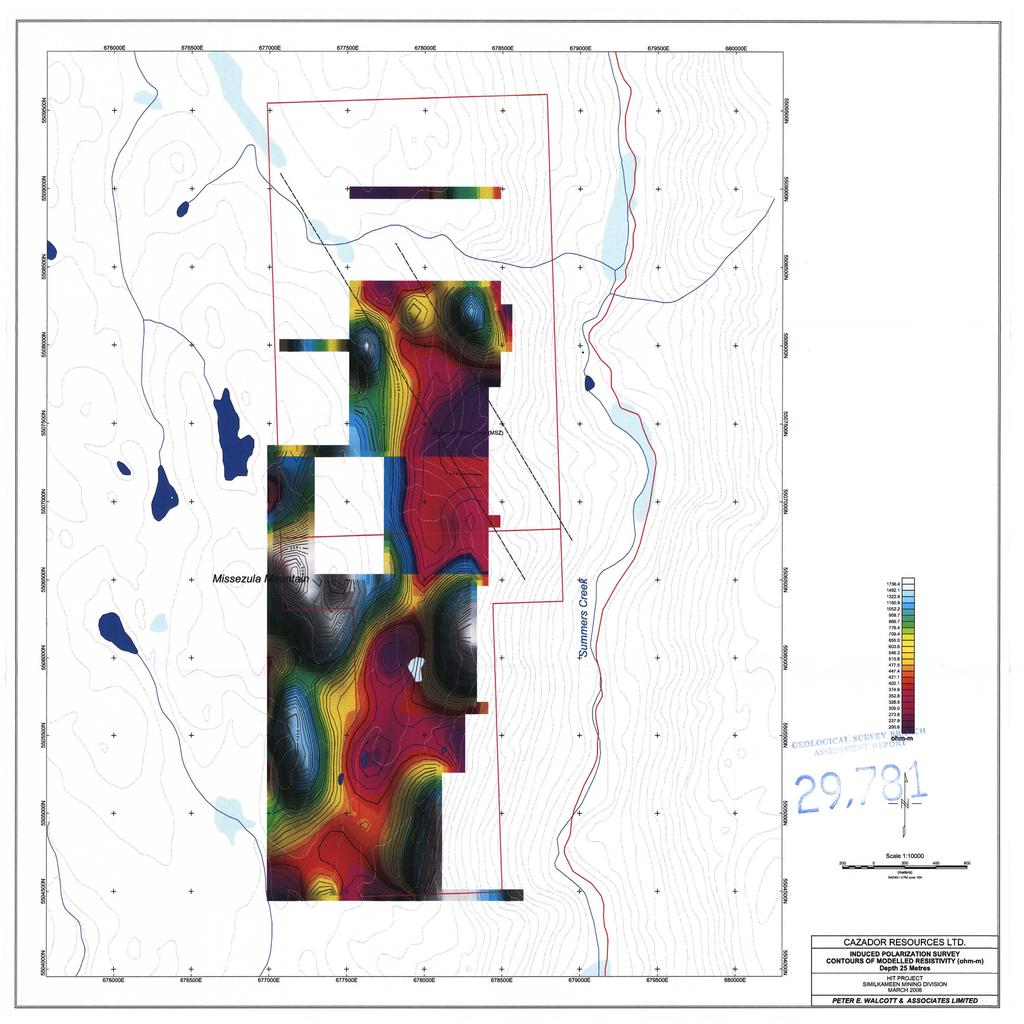
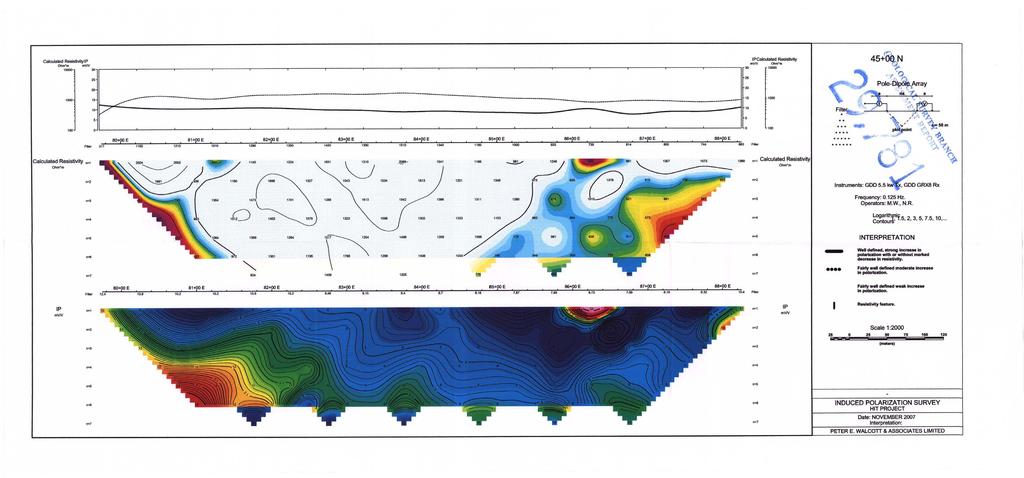
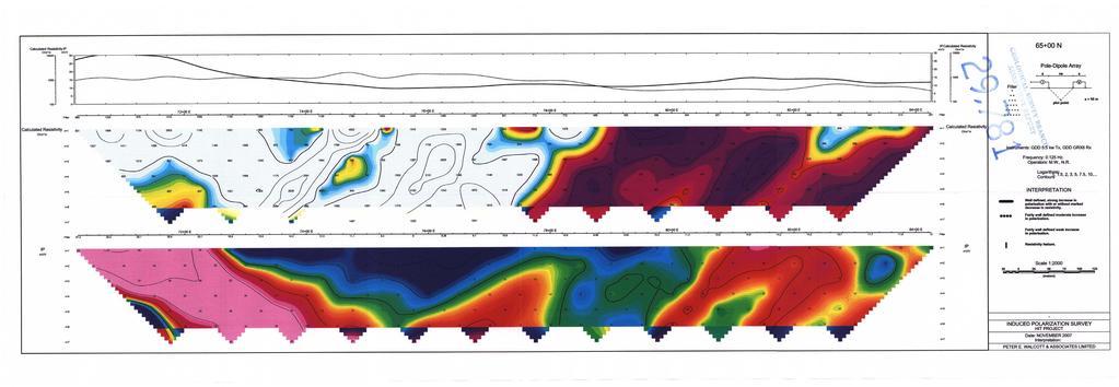
3 3 INTRODUCTION. Between November l6* and December 6,2007, Peter E. Walcott & Associates Limited undertook induced polarization (I.P.) surveying over parts of the Hit property, located some 30 kilometres southeast of the community of Aspen Grove, British Columbia, for Cazador Resources Ltd. The survey was carried out over fourteen east-west oriented lines established by line cutters. The orientation of the grid was UTM north approximately 2.5 degrees east of true north. The southern most grid was 4500N at the southern property boundary and the most northern was at WON at the northern property boundary. Measurements - first to sixth separation - of apparent chargeability - the I.P. response parameter - and resistivity were made on each of the line traverses using the pole - dipole technique with a combination of 12.5,25 & 50 metre dipoles on selected lines. In addition the elevations and horizontal locations of the line stations were measured using a Brunton altimeter and an Garmin C60 WAAS equipped GPS unit respectively. The I.P. chargeability and resistivity data are presented as individual pseudo sections at a scale of 15,000. In addition the 25, 50 and 100 meter depth chargeability and resistivity measurements are presented in coloured contour form on plan maps of the line grid at a scale of 1 : 10,000. PURPOSE, The purpose of the survey was to (a) trace out the possible extension of the porphyry style chargeability anomaly obsefved on the Axe property adjoining to the south, and (b) to explore for vein mineralization in the northern portion of the prom where mineralization in quartz veins is known to exist. SURVEY SPECIFICATIONS, The Induced Polarization Survev. The induced polarization (I.P.) survey was conducted using a pulse type system, the principal components of which were manufactured by Iris Instruments of Orleans, France and Instrumentation GDD Inc. of St. Foy, Quebec. The system consists basically of three units, a receiver (Iris), transmitter (GDD) and a motor generator (Honda). The transmitter, which provides a maximum of 3.6 kw d.c. to the ground, obtains its power from a 5.0 kw 600 C.P.S. single phase alternator driven by a Honda 11 h.p. gasoline engine. The cycling rate of the transmitter is 2 seconds current- Peter E Walcott & Associates Limited Geophysical Sen4ce-s induced Polarizatio~~ Surveying Hitproperty
4 4 on and 2 seconds current-off with the pulses reversing continuously in polarity. The data recorded in the field consists of carehl measurements of the current (I) in amperes flowing through the current electrodes C1 and C2, the primary voltages (V) appearing between any two sequential potential electrodes, P1 through Pn+l, during the current-on part of the cycle, and the apparent chargeability, (Ma) presented as a direct readout in millivolts per volt using a 200 millisecond delay and a 1000 millisecond sample window by the receiver, a digital receiver controlled by a micro-processor - the sample window is actually the total of ten individual windows of 100 millisecond widths. The apparent resistivity ( [J in ohm metres is proportional to the ratio of the primary voltage and the measured current, the proportionality factor depending on the geometry of the may used. The chargeability and resistivity are called apparent as they are values which that portion of the earth sampled would have if it were homogeneous. As the earth sampled is usually inhomogeneous the calculated apparent chargeability and resistivity are hctions of the actual chargeability and resistivity of the rocks. The survey was carried out using the pole-dipole method of surveying. In this method the cmnt electrode, C1, and the potential electrodes, PI through Pn+l, are moved in unison along the survey lines at a spacing of a (the dipole) apart, while the second current electrode, C2, is kept constant at i&nity. The distance, na between C1 and the nearest potential electrode generally controls the depth to be explored by the particular separation, n, traverse. On this survey a 90 metre dipole was employed and first to sixth separation readings were obtained on Lines 4500N to 7300N. A 25 metre dipole was employed on Lines 7800N to 84OON, and 9000N, while 12.5 readings were conducted on Lines 8200N and 8600N. In all some 18 kilometres of I.P. traversing were completed. Vertical control. The elevations of the stations were recorded using an ADC Summit altimeter manufactured by Brunton of Wyoming, USA. This instrument measures elevations using barometric pressures to an accuracy of plus or minus 3 metres. Corrections for errors due to variations in atmospheric pressure were made by comparison to readings obtained on a similar instrument, held stationary at one location - the base 0, at 10 minute intervals. Horizontal control. The horizontal position of the stations were recorded using a Garmin C60 WAAS enabled GPS unit. Data Presentation. The I.P. data are presented as individual pseudo section plots of apparent chargeability and resistivity at a scale of 1:5,000. Peter E. Wakott & Associates Limited Geophysical Services Induced Polarization Surveying Hitproperty
5 5 Contour plans of the 25, 50 and 100 meter depth chargeability and resistivity, on an idealized grid, are also added at a scale of 1 : 10,000. The survey area was covered using different spacing to define smaller structures in the northern portion of the survey area, and a larger porphyry system in the southern portion of the survey area. Lines 4300N to 7300N were measured using a 50 metre dipole spacing. The lines were extended off the property boundary to the west in order to obtain suflficient background for subsequent inversion of the data. Lines 7800N to 9000N were measured using 25 metre dipole spacing in an attempt to define mineralized structures proximal to the Hit showing, along with two 12.5 metre test lines Line 8200N and Line 8600N The resistivity over the survey area, shows a dominant north-northeasterly trending low with large northwesterly crosscutting structure likely associated with the Missezula Shear Zone (MSZ) in the north. The Hit showing, appears to be located on the northern side of this structure. A smaller structure can also be seen in the south showing a resistivity low and moderate chargeability adjacent to the Miss showing. However, due to line spacing and extents of the survey coverage minimal information can be obtained. The chargeability shows a similar type pattern, to the resistivity trend. The south eastern chargeability anomaly is likely attributed to a previously mapped pyritic quartz porphyry unit. This unit appears to be truncated in the north by the MSZ around Line 6900N. A larger anomaly open to the north on Line 8400N and extending south to Line 8000N is also of interest due to the proximity to the hit showing, and increased mistivity. It should be noted that 2D inversions in this region may not be valid due to the large crosscutting structure. Between November 16* and December 6*, 2007, Peter E. Walcott and Associates Limited undertook induced polarization traversing over parts of the Hit property for Cazador Resources Ltd. The property is located on the east slopes of Missezula Mountain, some 30 kilometres south-southeast of the community of Aspen Grove, British Columbia. The survey was carried out over fourteen east-west trending lines with a 25 & 50 metre dipole on the IP portion with two 12.5 dipole test lines. The IP survey outlined the presence of essentially three chargeability zones, all of which are open. Peter E. Walcott & Associates L fmi Geophysical Services Induced Polarization Surveying ~tproperty
6 6 The geophysical lines should be extended in the southern portion on the property to the eastern property boundary, and possible infill lines if warranted in the area of the Miss showing. The survey area in the north in the area of the Hit showing should be extended to close off the anomaly with possible infill lines to allow for the 3D inversion of the data. Prior to any fbrther geophysical work a compilation of the existing data, should be extensively reviewed. Respectfully submitted, PETER E. WALCOTT & ASSOCIATES LIMITED Peter E. Walcott, P.Eng. Geophysicist Vancouver, B.C. March 17,2008 Peter E. Wdcott & Assodates Limited Geophysical Services Induced Polarization Surveying Hit property
7 7 COST OF SURVEY. APPENDIX Peter E. Walcott & Associates Limited undertook the line establishment and the I.P. on a daily basis. Mobilization and reporting costs were extra so that the total cost of services provided was $89, PERSONNEL EMPLOYED ON SURVEY. Name Occmation Address Dates Peter E. Walcott Geophysicist Peter E. Walcott & Associates Limited W. 2Qd Ave., Vancouver, B.C. V6J lh2 Nov. 14th, 2007 Alexander Wdcott M. Welz John Cornock IL tt LL Dec. 8",2007 Mar. 3d -4h, 2008 Mar. ZUd - 3d, 2008 Dec. 3d - 5*, 2007 Guillermo Munoz LL N0v.16"-17~, 2007 C. Gugins LL Nov. Bb- De~2"~ 2007 T. Scott Geophysical Assistant Vt Nov. 16 *- Dec. 5' 2007 R, Weins tt tt It D. Little N. Russel S.Cochrane W, Natomagan tt tt tt Nov 18*-Dec 5* 2007 LL b9 tt Nov. 16st -17*, 07 C. Roe L. Gregory Line establishment tt tt Nov. 14*-Dec 4*07 It J. Walcott It Mar 16&,2008 Peter FL Walcott & Associates Limited GeophysiCaiServiceS Induced Polarization Surveying HithPerty
8 CERTIFICATION. I, Peter E. Walcott of 605 Rutland Court, Coquitlam, British Columbia, hereby certify that: 1. I am a graduate of the University of Toronto in 1962 with a B.A.Sc. in Engineering Physics, Geophysics Option. 2. I have been practicing my profession for the last forty five years. 3. I am a member of the Association of Professional Engineers of British Columbia and Ontario. 4. I hold no interest, direct or indirect in Cazador Resources Ltd. or Avanti Mining Inc. nor do I expect to receive any. Peter E.Walcott, P.Eng. Vancouver, RC. March 17,2008 Peter E. Walcott & Associates Limited Geophysical Services Induced Polarization Surveying Hit Property
9

10
11

12

13
14
15

16

17

18

19
20

21

22

23
24

25
26

27
28

29
A REPORT. Bear Lake, British Columbia (56' 13'N, ~) N.T.S. 94 D U& Claims surveyed: BL 1, units 2
 N.T.S. 94 D U& Claims surveyed: BL 1, units 2") I PETER E. WALCOTl' Rr ASSOC. LTD. A REPORT AN INDUCED POLARIZATION SURVEY T.?. d." Bear Lake, British Columbia rnk (56' 13'N, 1270 49~) N.T.S. 94 D U& *o Claims surveyed: BL 1, units 2 *a* & 3 BL 2, units
I PETER E. WALCOTl' Rr ASSOC. LTD. A REPORT AN INDUCED POLARIZATION SURVEY T.?. d." Bear Lake, British Columbia rnk (56' 13'N, 1270 49~) N.T.S. 94 D U& *o Claims surveyed: BL 1, units 2 *a* & 3 BL 2, units
PIOTR LUTYNSKI VANCOUVER, BRITISH COLUMBIA
 AN ASSESSMENT REPORT ON GROUND MAGNETIC SURVEYING CHUCHI PROPERTY FORT ST. JAMES AREA, BRITISH COLUMBIA OMINECA M.D. 55 17 N, 124 31 W NTS 93N/ 7&8 Claims Surveyed: 597976, 597878-597880 Survey Dates:
--_- A GEOPHYSICAL REPORT AN INDUCED POLARIZATION-SURVEY EQUITY SILVER MINES LIMITED_. John Wesley Ma11 Daniel Morice Merkley Gloria May Merkley
 --_- PETER E. WALCOTI' & ASSOC. LTD. A GEOPHYSICAL REPORT ON AN INDUCED POLARIZATION-SURVEY Houston Area, British Columbia 54O 27'N, 126" 39'W N.T.S. 93L/7E Claims sur-ed: HD 3 & 4 Survey Dates: Sept 16th
GEOPHYSICAL ASSESSMENT REPORT ON THE CATALAN COPPER PROPERTY
 GEOPHYSICAL ASSESSMENT REPORT ON THE CATALAN COPPER PROPERTY McLeese Lake Area, B.C. NTS Map No. 93B/09 52"30'N Latitude 122"lO'W Longitude For: Operator, Stikine Gold Corporation 490-1 122 Mainland St.
A GEOPHYSICAL REPORT INDUCED POLARIZATION & MAGNETIC SURVEYING
 I A GEOPHYSICAL REPORT INDUCED POLARIZATION & MAGNETIC SURVEYING Bluff Property,,- Cariboo Mining District, B.G4 52"Ol'N, 121" 187W%\% 1,-. N.T.S. 93A004(\? c, ',
EVENT # AN ASSESSMENT REPORT INDUCED POLARIZATION SURVEYING
 EVENT # 55345 AN ASSESSMENT REPORT ON INDUCED POLARIZATION SURVEYING Fort St. James Area, Omineca M.D., B.C. 54 56 N, 4 ' W NTS: 93N/6 Claims Surveyed: 53537, 5353, 5354, 534 Survey Dates: October st November
GEOPHYSICAL REPORT ON THE PRINCE GEORGE PORPHYRY PROJECT HOBBES PROPERTY
 GEOPHYSICAL REPORT ON THE PRINCE GEORGE PORPHYRY PROJECT HOBBES PROPERTY CARIBOO MINING DIVISION, British Columbia NTS: 093J/06, 093J/11 Latitude 54 30 23 N, Longitude 123 7 52 W MTO Event Numbers 4997107;
GEOPHYSICAL REPORT ON THE PRINCE GEORGE PORPHYRY PROJECT LYNX PROPERTY
 GEOPHYSICAL REPORT ON THE PRINCE GEORGE PORPHYRY PROJECT LYNX PROPERTY Lynx Property Omenica Mining Division British Columbia Tenure # 841107, 742942, 741962 NTS Sheet 093K MTO Event Number - 5434711 UTM
B.C. Vancouver, Sritish Columbia. Ragas Claims, Omenica M.D., A GEOPHYSICAL REPORT. A GROUKD NAGMETIC 6: ELECTRO?.IAGr\TETIC SURVEY FOR
 A GEOPHYSICAL REPORT A GROUKD NAGMETIC 6: ELECTRO?.IAGr\TETIC SURVEY Ragas Claims, Omenica M.D., B.C. FOR CATRE - 3EK JOINT VENTURE PETER E. WALCOTT & ASSOC. LIPIITED Vancouver, Sritish Columbia OCTOEEEt
Trout Lake Area, British Columbia (500, 50' N., 117O 40' t?) Claims surveyed: WE, VIK. Survey Dates: June 6th - " 12th, 84 FOR
 Claims surveyed: WE, VIK. Survey Dates: June 6th - 12th, 84 FOR") PETER E. WALCOTT Rr ASSOC. LTD. P ~ L C ~ \%%95 GEOLOGICAL BRANCH ASSb:fiSMENT REPOPT A GEOPlIYSICAL REPORT Trout Lake Area, British Columbia (500, 50' N., 117O 40' t?) Claims surveyed: WE, VIK Survey
PETER E. WALCOTT Rr ASSOC. LTD. P ~ L C ~ \%%95 GEOLOGICAL BRANCH ASSb:fiSMENT REPOPT A GEOPlIYSICAL REPORT Trout Lake Area, British Columbia (500, 50' N., 117O 40' t?) Claims surveyed: WE, VIK Survey
r Department of Mines and P,1Pr2!sum Resources I ... ' AS f 5 5 E t.! T R E p (J RT Mt, Sicker, Duncan Area, Vancouver Island, B.C.
 45- I A REPORT - ON AN ELECTROMAGNETIC SURVEY Mt, Sicker, Duncan Area, Vancouver Island, B.C. DUCANEX RESOURCES LIMITED Vancouver, British Columbia r Department of Mines and P,1Pr2!sum Resources I AS f
SUMMl'l WlLS LIU. GEOPHYSICAL REPORT. W. CT. a~evenson Y I
 SUMMl'l WlLS LIU. GEOPHYSICAL REPORT W. CT. a~evenson Y3 qi@, 1970. I 2-90 9 CONTENTS - PAGE Introduction... 1 Property... 1 Location and Access... 1 Survey Specifications Survey Grid... 1 Induced Polarization
COMINCO LTD. GEOPHYSICAL REPORT ON AN INDUCED POLARIZATION SURVEY RIM PROPERTY RAFT RIVER AREA KAMLOOPS MINING DIVISION,
 COMNCO LTD. EX PLORAT ON WESTERN DSTRCT NTS: 82M/13E 25 JUNE 1981 GEOPHYSCAL REPORT ON AN NDUCED POLARZATON SURVEY RM PROPERTY RAFT RVER AREA KAMLOOPS MNNG DVSON, B.C. LATTUDE: 51'52'N LONGTUDE : 11 9'45
GEOPHYSICAL REPORT ON AN INDUCED POLAR.IZATION SURVEY
 GEOPHYSICAL REPORT ON AN INDUCED POLAR.IZATION SURVEY T & V Claim Groups some 12 miles Northwest of Babine Lake, B.C. Latitude 55' 26'N Longitude 126' 35'W AUTHOR: Glen E. White, Chief Geophysicist,a,
COMINCO LTD. HORIZONTAL LOOP EM AND MAGNETIC SURVEYS ON SHA. CLAIMS 1, 2, 7 and 8 NELSON AND FORT STEELE MINING DIVISIONS, B.C.
 COMINCO LTD. EXPLORATION WESTERN DISTRICT NTS: 82-F/1 HORIZONTAL LOOP EM AND MAGNETIC SURVEYS ON SHA CLAIMS 1, 2, 7 and 8 - ASSESSMENT REPORT - NELSON AND FORT STEELE MINING DIVISIONS, B.C. Latitude Longitude
LLOYD MINERALS INC. VANCOUVER, BRITISH COLUMBIA
 EVENT # 836 AN ASSESSMENT REPORT ON HELIBORNE MAGNETIC SURVEYING BIG ONION PROPERTY SMITHERS AREA, BRITISH COLUMBIA OMINECA M.D. 4 48.8 N, 6 3.76 W NTS 94L/W Claims: 374,37,376,6867,76,88893,63,64467,64468
GEOPHYSICAL REPORT INDUCED POLARIZATION/RESISTMTY SURVEYS. on behalf of TEESHIN REOURCES LTD Argus Road. Oakville, Ontario L6J 354
 GEOPHYSICAL REPORT INDUCED POLARIZATION/RESISTMTY SURVEYS DOME MOUNTAIN PROPERTY, SMITHERS AREA CHRIS, APRIL 1, APRIL 2, APRIL 3, AND MAG 1 CLAIMS CMINECA MINING DMSION, BRITISH COLUMBIA Latitude: 546
September 23rd-26th, 2016,May 18th, 2017 YEAR OF WORK: 16/ , , ,
 Ministry of Energy and Mines BC Geological Survey Assessment Report Title Page and Summary TYPE OF REPORT [type of survey(s)]: induced polarization/airborne magnetic TOTAL COST: 23,4 AUTHOR(S): Walcott,
t+o...&zz!. ASSESSMENT REPORT Department of Miner and Petroleum Resources MAP.,- INDUCED POLAKIZATION SURVEY OVER THE BROOKS PROSPECT
 5873 INDUCED POLAKIZATION SURVEY OVER THE BROOKS PROSPECT BROOKS PENINSULA AREA VANCOUVER ISLAND, B.C. NANAIMO AND ALBERNI MINING DIVISIONS BY Z. B. DOBORZYNSKI JANUARY, 1976 Department of Miner and Petroleum
PHOENIX GEOPHYSICS LIMITED REPORT ON THE VLF-EM AND TOTAL FIELD MAGNETOMETER SURVEYS ON THE
 PHOENIX GEOPHYSICS LIMITED REPORT ON THE VLF-EM AND TOTAL FIELD MAGNETOMETER SURVEYS ON THE TAN CLAIMS, CHILLIWACK AREA NEW WESTMINSTER MINING DIVISION, BRITISH COLUMBIA FOR LORNEX MINING CORPORATION LIMITED
LIST OF FIGURES APPENDICES
 RESISTIVITY / INDUCED POLARIZATION SURVEY EL PORVENIR PROJECT MUNICIPALITY OF REMEDIOS, ANTIOQUIA, COLOMBIA LOGISTICS REPORT M-17427 APRIL 2017 TABLE OF CONTENTS Abstract... 1 1. The Mandate... 2 2. El
FINAL REPORT GEOPHYSICAL INVESTIGATION VILLAGE ALHAMBRA RETENTION POND SITE THE VILLAGES, FLORIDA
 FINAL REPORT GEOPHYSICAL INVESTIGATION VILLAGE ALHAMBRA RETENTION POND SITE THE VILLAGES, FLORIDA Prepared for Andreyev Engineering, Inc. Oxford, FL Prepared by GeoView, Inc. St. Petersburg, FL August
Fox 2-Record No. 2524
 F HELICOPTER E.M. AND MAGNETOMETER SURVEY OVER THE FOX CLAIMS, OMINECA MINING DISTRICT BRITISH COLUMBIA ON BEHALF OF OWNER MR. MIKE BOYLE Claims: Fox l-record No. 2523 Fox 2-Record No. 2524 Location 126'
UTM (NAD 83, ZONE 10) rq df;- LLOYD GEOPHYSICS INC. VANCOUVER, BRITISH COLUMBIA APRIL, 2004
 rq df;- LLOYD GEOPHYSICS INC. VANCOUVER, BRITISH COLUMBIA APRIL, 2004") 1 A GEOPHYSICAL REPORT ON AN INDUCED POLARIZATION SURVEY ON THE RAD PROPERTY, CLINTON MINING DIVISION, TATLA LAKE, BRITISH COLUMBIA. UTM (NAD 83, ZONE 10) - $ 3 5730000 m NORTH \:. 427500 rq df;- c3-+;,l
1 A GEOPHYSICAL REPORT ON AN INDUCED POLARIZATION SURVEY ON THE RAD PROPERTY, CLINTON MINING DIVISION, TATLA LAKE, BRITISH COLUMBIA. UTM (NAD 83, ZONE 10) - $ 3 5730000 m NORTH \:. 427500 rq df;- c3-+;,l
GEOPHYSICAL REPORT. Airborne Magnetometer Survey. of the SHEEP-GOAT GROUP OF MINERAL CLAIMS. near Li l looet, B.C.
 GEOPHYSICAL REPORT 977 Airborne Magnetometer Survey of the SHEEP-GOAT GROUP OF MINERAL CLAIMS near Li l looet, B.C. Lillooet Mining Division (Lat.51 'lot Long. 122 40' 7 5t0[2L05E. for DUFFEY LAKES MINES
We are committed to providing accessible customer service. If you need accessible formats or communications supports, please contact us.
 We are committed to providing accessible customer service. If you need accessible formats or communications supports, please contact us. Nous tenons à améliorer l accessibilité des services à la clientèle.
Airborne Geophysical TOTAL COST: $8, ,
 Ministry of Energy, Mines & Petroleum Resources Mining & Minerals Division BC Geological Survey Assessment Report Title Page and Summary TYPE OF REPORT [type of survey(s)]: Airborne Geophysical TOTAL COST:
, , ,
 Ministry of Energy and Mines BC Geological Survey Assessment Report Title Page and Summary TYPE OF REPORT [type of survey(s)]: Airborne Geophysic TOTAL COST: 9,4. AUTHOR(S): Walcott, A. Walcott, P SIGNATURE(S):
, ,
 Ministry of Energy, Mines & Petroleum Resources Mining & Minerals Division BC Geological Survey Assessment Report Title Page and Summary TYPE OF REPORT [type of survey(s)]: Airborne Magnetic Survey TOTAL
ASSESSMENT REPORT I.P./RESISTIVITY AND MAGNETICS SURVEY ON THE HAUTETE PROPERTY LATITUDE: 55O 12' N LONGITUDE: 126O 07' W
 NTS: 93W1 ASSESSMENT REPORT I.P./RESISTIVITY AND MAGNETICS SURVEY ON THE HAUTETE PROPERTY LATITUDE: 55O 12' N LONGITUDE: 126O 07' W OMINECA MINING DISTRICI'. B.C. CLAIMS COVERED : TET 1-8 TIME PERIOD:
GEOPHYSICAL REPORT THE CAVZ CLAIMS
 GEOPHYSICAL REPORT Magnetometer Survey on THE CAVZ CLAIMS CAVZ M.C.'s 1 to 12, 15 to 26, 29 to 40, 45 to 54 Trail Peak, Omineca M.D. 13 miles northeast of Fort Babine 550 ) 126 S.E. by G.Podolsky J.Russell
We are committed to providing accessible customer service. If you need accessible formats or communications supports, please contact us.
 We are committed to providing accessible customer service. If you need accessible formats or communications supports, please contact us. Nous tenons à améliorer l accessibilité des services à la clientèle.
compietea since tnat date, and wnicn comprisea btage I ot tne recommended
 compietea since tnat date, and wnicn comprisea btage I ot tne recommended four-stage program. GEOLOGY & MINERALIZATION The property situate6 on the southeast slope of Nickel Plate Mtn., and within the
Report of Gridding and Magnetic Surveys. On the. Munro Property. Munro and Beatty Townships, Ontario. Larder Lake Mining Division
 Report of Gridding and Magnetic Surveys On the Munro Property Munro and Beatty Townships, Ontario Larder Lake Mining Division Claims: 39 4244 For Big Red Diamond Corporation October 3, 2 Timmins, Ontario
HELICOPTER MAGNETIC SURVEY MISINCHINKA RANGE AREA, B.C. ONINECA MINING DIVISION. on behalf of STOKES EXPLORATION MANAGEMENT LTD.
 HELICOPTER MAGNETIC SURVEY MISINCHINKA RANGE AREA, B.C. ONINECA MINING DIVISION on behalf of STOKES EXPLORATION MANAGEMENT LTD. Claims : FALCON $1, FALCON #2 Location: Dated: About 7% kilometers N.E. of
SELF POTENTIAL SURVEY OVER THE JAY GROUP, INVERMERE AREA GOLDEN MINING DIVISION, BFUTISH COLUMBIA NTS 82W8W7 82W9W LATLONG 50 30' ' FOR
 - GEOLOGICAL SURVEY BRANCH ASSESSMENT REPORTS -- -- DATE RECEI?/::D 06T 10 1996 - SELF POTENTIAL SURVEY OVER THE JAY GROUP, INVERMERE AREA GOLDEN MINING DIVISION, BFUTISH COLUMBIA NTS 82W8W7 82W9W LATLONG
'?a October 31, 1990 COMINCO LTD. EXPLORATION NTS: 93 G-6. Cariboo Mining Division. Latitude: 53 deg. 16' N Longitude: 123 deg.
 COMINCO LTD. EXPLORATION NTS: 93 G-6 WESTERN DISTR CT Cariboo Mining Division Latitude: 53 deg. 16' N Longitude: 123 deg. 13' W Work Dates: June 7-8, 1990 '?a October 31, 1990 D.J. Holcombe ....... A ASSESSMENT
UNION MINIERE EXPLORATIONS AND MINING CORPORATION LIMITED ASSESSMENT REPORT ON FITINAT MINERAL CLAIM. Alberni Mining Division Record No.
 M F )( UNION MINIERE EXPLORATIONS AND MINING CORPORATION LIMITED Suite 200, 4299 Canada Way, Burnaby, B.C. V5G 1 H4 Telephone (604) 437-9491 ASSESSMENT REPORT ON GEOCHEMICAL SOIL SURVEYS AND ROCKSAMPLING
AN INDUCED~ POLARIZATION SURVEY. HIGHLAND VALLEY, BRITISH CoLUMBIA. (50, lil, SE) for JERICHO MINES LIMITED HUNTING SURVEY CORPORATION LIMITED
 for JERICHO MINES LIMITED HUNTING SURVEY CORPORATION LIMITED") AN INDUCED~ POLARIZATION SURVEY JERICHO PROPERTY HIGHLAND VALLEY, BRITISH CoLUMBIA (50, lil, SE) for. JERICHO MINES LIMITED HUNTING SURVEY CORPORATION LIMITED Toronto, Ontario December, 1962 u TABLE OF
AN INDUCED~ POLARIZATION SURVEY JERICHO PROPERTY HIGHLAND VALLEY, BRITISH CoLUMBIA (50, lil, SE) for. JERICHO MINES LIMITED HUNTING SURVEY CORPORATION LIMITED Toronto, Ontario December, 1962 u TABLE OF
7 MILES WEST OF PORT HARDY, B.C.
 GEOPHYSICAL REPORT VERTICAL INTENSITY MAGNETOMEER SURVEY ON LUK CLAIMS, 7 MILES WEST OF PORT HARDY, B.C. 50' 127O SE BY R. E. SHIELDS UNDER SUPERVISION OF J. R. BILLINGSLEY FOR SECOND0 MINING LTD. (N.
Report of Induced Polarization Surveys and. Total Field Magnetic Surveys. Turtle Pond, Emmons Lake, Prig, North Glatz, Glatz, and Double E Grids
 Report of nduced Polarization Surveys and Total Field Magnetic Surveys On the Turtlepond Project Turtle Pond, Emmons Lake, Prig, North Glatz, Glatz, and Double E Grids Turtlepond Lake Area, Ontario Claim
The survey covered claims, in part or in full, DUCKLING 3, 4, 5, 4 fraction, and 5 fraction.
 514 687-6671 XXX- 602 West Hastin~a StroeP, Vata;sn@ouver, BritlsA fhlum~b~a, Garaadsa B81apphgtaa DISCUSS ION OF MAGNETOMETER SURVEY ON DUCKLING CLAIMS FOR DONNA MINES LTD. (N0P.L.) Submitted to: DONNA
Report. On a 3D Magnetic Inversion. For. Cadillac Ventures Ltd. And. Newcastle Minerals Ltd. Pickle Lake Project. Ontario, Canada
 Report On a 3D Magnetic Inversion For Cadillac Ventures Ltd And Newcastle Minerals Ltd. Pickle Lake Project Ontario, Canada SCOTT HOGG & ASSOCIATES LTD October 2010 TABLE OF CONTENTS 1 INTRODUCTION...
CJP EXPLORATION INC.
 PO Box 219 14579 Government Road Larder Lake, Ontario P0K 1L0, Canada Phone (705) 643-1122 Fax (705) 643-2191 CJP EXPLORATION INC. Spectrometer Survey Over the SHEBA PROPERTY Nouvel Township, Ontario TABLE
'-7' REPORT ON A MAGNETOMETER SURVEY OVER PART OF THE MAX CLAIM GROUP 1-20 LAC LE JEUNE AREA KAMLOOPS MINING DIVISION KAMLOOPS, BRITISH COLUMBIA
 I,., - SUITE 102. 222 BELLEVUE WES t ANCOUVER, B. '-7' REPORT ON A I MAGNETOMETER SURVEY OVER PART OF THE MAX CLAIM GROUP 1-20 LAC LE JEUNE AREA KAMLOOPS MINING DIVISION KAMLOOPS, BRITISH COLUMBIA 50-30
MEMORANDUM. Interpretation of Magnetic and Volterra-3DIP survey MC Claims
 11966 95A Avenue, Delta, BC V4C 3W2 Canada Tel +1 (604) 582-1100 www.sjgeophysics.com MEMORANDUM Date: September 13, 2017 From: To: SUBJECT: E. Trent Pezzot Bonanza Mining Corporation Interpretation of
VLF and GRADIOMETER SURVEY OVER THE CAT GROUP, INVERMERE AREA GOLDEN MINING DIVISION, BRITISH COLUMBIA NTS 82K/O8W LAT/LONG 50 29' ' FOR
 VLF and GRADIOMETER SURVEY OVER THE CAT GROUP, INVERMERE AREA GOLDEN MINING DIVISION, BRITISH COLUMBIA NTS 82K/O8W LAT/LONG 50 29' - 116 15' FOR W. POCHYLKO STETTLER, ALBERTA BY T.R.B. DUNDAS ISOGEOS EXPLORATION
We are committed to providing accessible customer service. If you need accessible formats or communications supports, please contact us.
 We are committed to providing accessible customer service. If you need accessible formats or communications supports, please contact us. Nous tenons à améliorer l accessibilité des services à la clientèle.
1 CLAIMS GEOPHYSICAL REPORT ON BOYAL SITUATE NORTHEAST OF TILLICUM MOUNTAIN GOLD AREA BURTON - NAKUSP SIQCAEJ MINING DIVISION
 GEOPHYSICAL REPORT ON BOYAL 1 CLAIMS SITUATE NORTHEAST OF TILLICUM MOUNTAIN GOLD AREA BURTON - NAKUSP SIQCAEJ MINING DIVISION CONSULTING GEOLOGIST AUGUST 1983 VANCOUVER B *C INDEX INTRODUCTION ooa,.eoaaa.aaaoaaooaoa~ao~o
POLARIZATION SURVEY. (Cant in Grid) P. E. Fox, Ph.D., P.Eng. Fox Geological Consultants Ltd West Hatings Street Vancouver, B.C.
 P. E. Fox, Ph.D., P.Eng. Fox Geological Consultants Ltd West Hatings Street Vancouver, B.C.") K)X GEOLOGCAL CONSULTANTS LTD - /2&% AN ASSESSMENT REPORT ON A TME DOMAN NDUCED POLARZATON SURVEY (Cant in Grid) CEOLOGCA'L BRA ASSESSMgNT RE P. E. Fox, Ph.D., P.Eng. Fox Geological Consultants Ltd. 410-675
K)X GEOLOGCAL CONSULTANTS LTD - /2&% AN ASSESSMENT REPORT ON A TME DOMAN NDUCED POLARZATON SURVEY (Cant in Grid) CEOLOGCA'L BRA ASSESSMgNT RE P. E. Fox, Ph.D., P.Eng. Fox Geological Consultants Ltd. 410-675
GEOLOGICAL MAPPING REPORT ON THE ASH MINERAL CLAIM OSOYOOS MINING DIVISION ASHNOLA RIVER MAP SHEET NTS M092,H019 MCBRIDE CREEK AREA, ASHNOLA RIVER,
 GEOLOGICAL MAPPING REPORT ON THE ASH MINERAL CLAIM OSOYOOS MINING DIVISION ASHNOLA RIVER MAP SHEET NTS M092,H019 LATITUDE 49 o O6, LONGITUDE 120 o 22 MCBRIDE CREEK AREA, ASHNOLA RIVER, KEREMEOS, B.C. CANADA
1 i I.; :<7 6EOLOGICAL BRANCH ASSESSMENT REPORT HLEM, VLF-EM AND MAGNETOMETER TEST SURVEY ON THE ARC PROPERTY FOR SURVEY BY SJ GEOPHYSICS LTD.
 f - ~ --- j LOG NO: MAR 2 a 1992,,, -- - - - -- L$TiC'P;: I.; 1 i HLEM, VLF-EM AND MAGNETOMETER TEST SURVEY ON THE ARC PROPERTY FOR SURVEY BY SJ GEOPHYSICS LTD. SLOCAN M.D., B.C. N.T.S. 88 F/10 d 2- :
Spectrometer Survey Over the Creelman-Roberts Property Roberts and Creelman Townships, Ontario
 PO Box 19 1479 Government Road Larder Lake, Ontario PK 1L, Canada Phone (7) 4-11 Fax (7) 4-191 Spectrometer Survey Over the Creelman-Roberts Property Roberts and Creelman Townships, Ontario Spectrometer
PROSPECTING REPORT THE WALLACE CLAIM OMENICA MINING DIVISION. 54" x6" 3.d d. for. Reako Exlorat ions Ltd. Wallace Rev. C.G.
 PROSPECTING REPORT ON THE WALLACE CLAIM OMENICA MINING DIVISION 54"44 14 1x6" 3.d d by David A. Howard P.Eng. for Reako Exlorat ions Ltd. Claim Locat ion Wallace Rev. C.G. #1560 Dome Mountain Area 9 3
BALTO RESOURCES LTD. (Owner & Operator) GEOPHYSICAL ASSESSMENT REPORT. (Event Number ) on the SED MINERAL CLAIM.
 GEOPHYSICAL ASSESSMENT REPORT. (Event Number ) on the SED MINERAL CLAIM.") BALTO RESOURCES LTD. (Owner & Operator) GEOPHYSICAL ASSESSMENT REPORT (Event Number 5173274) on the SED MINERAL CLAIM (Tenure 392163) Kamloops Mining Division NTS 092I.047 Centre of Work 5589550N, 667600E
BALTO RESOURCES LTD. (Owner & Operator) GEOPHYSICAL ASSESSMENT REPORT (Event Number 5173274) on the SED MINERAL CLAIM (Tenure 392163) Kamloops Mining Division NTS 092I.047 Centre of Work 5589550N, 667600E
J.D. Mason, Prof. Engineer. Report on the Reconnaissance Magnetometer Survey. Completed for. North American Platinum Corporation Ltd.
 Report on the Reconnaissance Magnetometer Survey Completed for North American Platinum Corporation Ltd. Olivine Mountain Property, Tulameen, B.C. J.D. Mason, Prof. Engineer. November 28, 1967. Certificate
32?un North of Hope, B.C.,
 Geological Reconnaissance Assessment Report on portions of the Gilt Creek Group (Mike, C.G., Julie, and Gilt Mineral Claims) Situated 32?un North of Hope, B.C., New Westminster Mining Division N 'P 97H/11W
_.----." 2) Gravimetric Profiles... In Pocket TABLE OF CONTENTS PAGE - SUMMARY AN0 CONCLUSIONS... 1A GRAVIMETRIC SURVEY Field Procedures...
 Gravimetric Profiles... In Pocket TABLE OF CONTENTS PAGE - SUMMARY AN0 CONCLUSIONS... 1A GRAVIMETRIC SURVEY Field Procedures...") _.----." TABLE OF CONTENTS PAGE - SUMMARY AN0 CONCLUSIONS... 1A GRAVIMETRIC SURVEY... 1 Field Procedures... 1 Elevation and Horizontal Control... 2 Meter Procedures... 2 Computing Procedures... 2 Plotting...
_.----." TABLE OF CONTENTS PAGE - SUMMARY AN0 CONCLUSIONS... 1A GRAVIMETRIC SURVEY... 1 Field Procedures... 1 Elevation and Horizontal Control... 2 Meter Procedures... 2 Computing Procedures... 2 Plotting...
NOTICE OF WORK PERMIT NUMBER(S)/DATE(S):
/DATE(S):") Ministry of Energy, Mines & Petroleum Resources Mining & Minerals Division BC Geological Survey Assessment Report Title Page and Summary TYPE OF REPORT [type of survey(s)]: Airborne Magnetic Survey TOTAL
Ministry of Energy, Mines & Petroleum Resources Mining & Minerals Division BC Geological Survey Assessment Report Title Page and Summary TYPE OF REPORT [type of survey(s)]: Airborne Magnetic Survey TOTAL
December 6th I960. President and Directors, Chipman Lake Mines Ltd. 25 King Street West, Toronto.
 OFFICE: EM, 3-3933 RES.: HU. 1-1265 "' Mfc 42A85NE0127 63.1089 GODFREY 010. D. President and Directors, Chipman Lake Mines Ltd. 25 King Street West, Toronto. December 6th I960 REPORT ON GEOPHYSICAL SURVEY
Geophysical Survey Interpretation Report
 116 Spadina Ave., Suite 400 Toronto, ON, M5V 2K6 Phone (416) 306 1941 Fax (416) 306 1949 Geophysical Survey Interpretation Report Quantec Titan-24 Distributed Acquisition System DC RESISTIVITY & INDUCED
CONTENTS 1. INTRODUCTION. 2. THE D.C. RESISTIVITY METHOD 2.1 Equipment 2.2 Survey Procedure 2.3 Data Reduction
 (i) CONTENTS 1. INTRODUCTION page 1 2. THE D.C. RESISTIVITY METHOD 2.1 Equipment 2.2 Survey Procedure 2.3 Data Reduction 3 3 3 3 3. GEOPHYSICAL RESULTS 3.1 General 3.2 Discussion 4 4 4 4. LIMITATIONS 5
BALTO RESOURCES LTD. (Owner & Operator) GEOPHYSICAL ASSESSMENT REPORT. (Event Number ) on the SED MINERAL CLAIM.
 GEOPHYSICAL ASSESSMENT REPORT. (Event Number ) on the SED MINERAL CLAIM.") BALTO RESOURCES LTD. (Owner & Operator) GEOPHYSICAL ASSESSMENT REPORT (Event Number 4829051) on the SED MINERAL CLAIM (Tenure 392163) Kamloops Mining Division NTS 092I.047 Centre of Work 5590150N, 678800E
BALTO RESOURCES LTD. (Owner & Operator) GEOPHYSICAL ASSESSMENT REPORT (Event Number 4829051) on the SED MINERAL CLAIM (Tenure 392163) Kamloops Mining Division NTS 092I.047 Centre of Work 5590150N, 678800E
PHYSICAL WORK REPORT. the BAY CLAIMS. Omineca Mining Division Smithers, British Columbia N.T.S. 93E 13E/W
 PHYSICAL WORK REPORT the BAY CLAIMS Omineca Mining Division Smithers, British Columbia a N.T.S. 93E 13E/W LATITUDE: 53 57 00 N I LONGITUDE: 127 45 OO W for Home Ventures Ltd. 1201-675 West Hastings Street
PROSPECTING Survey Over the AULD PROPERTY Auld Township, Ontario
 PO Box 219, 14579 Government Road, Larder Lake, Ontario, P0K 1L0, Canada Phone (705) 643-2345 Fax (705) 643-2191 www.cxsltd.com PROSPECTING Survey Over the AULD PROPERTY C Jason Ploeger, B.Sc, P.Geo August
NICOLA M.D King Street West, April, 1969 AMALG 1-44 MINERAL CLAIMS 1. OWNER: Dr. F. R. Burton, W. M. Sirola, P. Eng.
 REPORT ON ' MAGNETIC AND ELECTROMAGNETIC SURVEY AMALG 1-44 MINERAL CLAIMS 1. NICOLA M.D. 49'501 N - 12Oo57f W OWNER: Dr. F. R. Burton, 1506-44 King Street West, Toronto 1, Ontario. by W. M. Sirola, P.
Gold Mountain Group Gold Mtn. A, B, C & D Mineral Claims Record Nos. 697, 698, 699 & 700. Island Mountain Cariboo Mining Division British Columbia
 GOLD POINT RESOURCES LTD. Geophysical Survey Gold Mountain Group Gold Mtn. A, B, C & D Mineral Claims Record Nos. 697, 698, 699 & 700 Island Mountain Cariboo Mining Division British Columbia Vancouver,
GEOCSZNICAL - SURVEY. ICAMLOOPS Kl.D. 2'' 6;kr. HY "'f. Alfred R. Allen,P.Eng. 1 NO.%=...,... 6"- 'I.
 t i.i GEOCSZNICAL - SURVEY i p' ICAMLOOPS Kl.D. 2'' 6;kr HY 50-64 +."'f 121-51 NE 5-10-70 : 19-10-70 Alfred R. Allen,P.Eng. I) ' 1 6"- 'I. 1 NO.%=...,..... Q.C. EXPLORATIONS LTD. 2Cl- 535 Kowe Street Vancouver
SKEAD HOLDINGS LTD. Prospecting Over the. PUSEY LAKE PROPERTY Cardiff Township, Ontario
 PO Box 219, 14579 Government Road, Larder Lake, Ontario, P0K 1L0, Canada Phone (705) 643-2345 Fax (705) 643-2191 www.cxsltd.com SKEAD HOLDINGS LTD. Prospecting Over the PUSEY LAKE PROPERTY Cardiff Township,
Introducti on. Land Survey. Geomagnetic Survey. Geomagnetic Results and Interpretati ons - Conclusions and Recommendations C
 m M 42A86SW8281 63.42 PRICE 010 C O H T E H l 42A86SW828I 63.42 PRICE 010C Introducti on Land Survey Geomagnetic Survey Geomagnetic Results and Interpretati ons - Conclusions and Recommendations - - -
GEOPHYSICAL REPORT CHU CHUA PROJECT Green Mountain Group. KAMLOOPS MINING DIVISION NTS 92P/8E, 82M/5W Lat: 51'24' N Long: 120'00' w
 I GEOPHYSICAL REPORT CHU CHUA PROJECT Green Mountain Group KAMLOOPS MINING DIVISION NTS 92P/8E, 82M/5W Lat: 51'24' N Long: 120'00' w I rvm #.,_..._..._._._.- $...-...! 1 VANCOUVER, B.C. 1 G E 0 I, 0.G
EXTREMELY FAST IP USED TO DELINEATE BURIED LANDFILLS. Norman R. Carlson, Cris Mauldin Mayerle, and Kenneth L. Zonge
 EXTREMELY FAST IP USED TO DELINEATE BURIED LANDFILLS Norman R. Carlson, Cris Mauldin Mayerle, and Kenneth L. Zonge Zonge Engineering and Research Organization, Inc. 3322 East Fort Lowell Road Tucson, Arizona,
AND HORSEFLY PROSPECTS, N.W. BRITISH COLUMBIA NTS, 103H/ll, 14 FOR ATNA RESOURCES LTD DELTA GEOSCIENCE LTD
 AND HORSEFLY PROSPECTS, N.W. BRITISH COLUMBIA NTS, 103H/ll, 14 FOR ATNA RESOURCES LTD BY DELTA GEOSCIENCE LTD FE T A. HENDRICKSON, P.GEO. 1 . TABLE OF CONTENTS Introduction............. Page 1. Personnel..........
GRAVITY AND MAGNETIC SURVEY NECHAKO BASIN STUDY ACQUISITION AND PROCESSING PHASE
 GRAVITY AND MAGNETIC SURVEY NECHAKO BASIN STUDY ACQUISITION AND PROCESSING PHASE Report prepared for the B.C. Ministry of Energy and Mines Resource Development Division New Ventures Branch by Bemex Consulting
EWS PETROLEUM CORPCWAT~ WEST HASTINGS STREET VANCOUVER, 8. C. V6C 186
 EWS PETROLEUM CORPCWAT~ 613-837 WEST HASTINGS STREET VANCOUVER, 8. C. V6C 186 GEOPHYSICAL REPORT on a VLF - ELECTROkAGNETlC SURVEY on the SHEBA MINERAL CLAIM CARIBOO MINING OIVISION NTS 93 H/3 Lat. 53
AN ASSESSMENT REPORT 0 INDUCED POLARIZATION SUR -~-? OPHIR PROPERTY *LI' Vd CLINTON MINING DMSION BRITISH COLUMBIA LATITUDE 51"SS'NORTH
 SUB-RECORDER RECEIVED DEC 19 1991 rv1.r. #. $..._ ~... VANCOUVER, B.C. AN ASSESSMENT REPORT 0 T..~-, 1991- INDUCED POLARIZATION SUR -~-?.,.*-- z --'1..... ' 6 : Q~tG!? i i I t OPHIR PROPERTY *LI' Vd CLINTON
490 20' 30" North Latitude ' 30" West Longitude
 _._.. I CONSULTING GEOLOGISTS 605-602 WEST HASTINGS STREET, VANCOUVER, B.C. V6B 1P2 TELEPHONE: (604) 689-5533 6 I F: ASSESSMENT REPORT ON THE PATSY 1 MINERAL CLAIM ' '?%2% I WHISTLE CREEK, HEDLEY ARE L-l-
SUPPLEMENT TO MAGNETOMETER 6 ELECTROMAGNETIC SURVEY REPORT. DATED NOVEMBER l, 1973 CIGLEN INVESTMENTS LIMITED CLAIMS GROUP BAD VERMILLION LAKE AREA
 ^ A R l ^ 1974 010 PROJECTS UNIT SUPPLEMENT TO MAGNETOMETER 6 ELECTROMAGNETIC SURVEY REPORT DATED NOVEMBER l, 1973 CIGLEN INVESTMENTS LIMITED CLAIMS GROUP BAD VERMILLION LAKE AREA DISTRICT OF RAINY RIVER
REPORT ON MAGNETOMETER SURVEY TIK-1 CLAIM e&f KAMLOOPS MINING DTVISION. by D. Hendry D. C. MILLER. February 3, for
 REPORT ON MAGNETOMETER SURVEY TIK-1 CLAIM 92-1-14 e&f KAMLOOPS MINING DTVISION lat. 50 57 ' 12" long. 121O23 ' 37" OWNER: ST. JOSEPH EXPLORATIONS LIMITED OPERATIOR: ST. JOSEPH EXPLORATIONS LIMITED by D.
on the Diamond Drilling done on the LAKESIOE GROUP of Mineral Claims SLOCAN MINING DIVISION 82-F-14-W Long ' Lat '
 Assessment Work Report on the Diamond Drilling done on the LAKESIOE GROUP of Mineral Claims SLOCAN MINING DIVISION 82-F-14-W Long 117 22' Lat. 49 58' ADRIAN KESLER SILVERTON, B.C. operator LEVON RESOURCES
NEWS RELEASE Ocean Park Ventures Identifies Large Multi-Structure Sulfide Mineralized System Trapper Gold Project, British Columbia
 Suite 302 750 West Pender St Vancouver, BC V6C 2T7 Tel: 604-681-0084 Fax: 604-681-0094 www.oceanparkventures.com TSX-V SYMBOL: OCP NEWS RELEASE Ocean Park Ventures Identifies Large Multi-Structure Sulfide
for the Greenwood Mining Division, B.C. NTS 82E/7W 29' W, Longitude 118' 53' N Prepared by D. Dylan Watt, B.Sc.
 for the FltE NO: u VOLT 1, VOLT 2, VOLT 3, & VOLT 4 CLAIMS Greenwood Mining Division, B.C. NTS 82E/7W Latitude 49' 29' W, Longitude 118' 53' N Prepared by D. Dylan Watt, B.Sc. #309-1996 Trutch Street Vancouver,
Interpretation Report on Borehole TDEM Surveys
 Interpretation Report on Borehole TDEM Surveys Junior Lake Property, Armstrong, Ontario For Landore Resources Canada Inc. Alan R. King, M.Sc., P.Geo. January 25, 2016 Introduction Alan King of Geoscience
GEOPHYSICAL REPORT ON A VLF-EM SURVEY OVER THE BOSS 1 AND 2 CLAIMS HEDLEY AREA SIMILKAMEEN MINING DIVISION BRITISH COLUMBIA
 GEOPHYSICAL REPORT i ON A VLF-EM SURVEY OVER THE BOSS 1 AND 2 CLAIMS HEDLEY AREA SIMILKAMEEN MINING DIVISION BRITISH COLUMBIA PROPERTY SURVEYED BY : 11.0 h S60W of Bedley : 49' 120O SE : N.T.S. 92~18~
FOR. Vancouver, British Columbia. Vancouver, British Co?.umbia PETE2. Dease Lake Area, British Columbia. NUSPA?l P?SOUP,CES LTD.
 I_ A REPORT AN IKDUCED POLYRIZATION SURVEY Dease Lake Area, British Columbia,f-. 1 FOR NUSPA?l P?SOUP,CES LTD. Vancouver, British Columbia MINERAL RESOURCES BRANCH BY PETE2 J" 4 ' Vancouver, British Co?.umbia
ASSESSMENT REPORT. including. IP and MMI Sampling. on the MP PROPERTY
 ASSESSMENT REPORT including IP and MMI Sampling on the MP PROPERTY CARIBOO MINING DIVISION, British Columbia NTS: 93G/09 Latitude 53 41' N, Longitude 122 24' W Prepared for Operators: FJORDLAND EXPLORATION
-KERR-ADDISON GOLD MINES LTD. 6EOPHYSICAL & GEOCHEMICAL INVESTIGATION. Of 24 CLAIMS Of THE FAULT GROUP OF MINERAL CLAIMS
 -KERR-ADDISON GOLD MINES LTD. 6EOPHYSICAL & GEOCHEMICAL INVESTIGATION Of 24 CLAIMS Of THE FAULT GROUP OF MINERAL CLAIMS Located About 3 Miles West Of Merritt, B.C. In Nicola M.D. 50 N - 120 w BY W. M.
Virgin River DCIP Report
 Virgin River 1 1 University of British Columbia Geophysical Facility Applied Geophysics, 2010 Outline 1 Location Survey Specications 2 3 Correlations Snowbird Tectonic Zone Outline Location Survey Specs
Main Menu. Douglas Oldenburg University of British Columbia Vancouver, BC, Canada
 Using ERA low frequency E-field profiling and UBC 3D frequency-domain inversion to delineate and discover a mineralized zone in Porcupine district, Ontario, Canada. Vlad Kaminski* University of British
NO. MAP..._._..._...,,..,.
 KERR- ADDISON GOLD MINES LIMITED SELF-POTENTIAL SURVEY OWL!i- 12 1 Dwner ) NAOINA 1-4 ) MINERAL CLAIMS W. F. McGowan, ) 3262 Marine Orive, ANGUS 1-4 ) west Vancouver, 8. c. LOCATED AT 5. E. ENO OF OWEN
For personal use only
 South America s Emerging Gold Explorer ASX Release 22 November 2012 OUTSTANDING GEOPHYSICS RESULTS FROM ALUMBRE AND QUINUAL CONCESSIONS HIGHLIGHTS Independent review of the Alumbre and Quinual concessions
... corrcluslons... 4 OF CONTENTS FOLD R AT M.CK OF REPORT. 1 Pl.AM*VlEW - APPARENT REStSTlVITY
 ;c ' t,..' A0,! 3-41 NO TA)tE OF CONTENTS... HSTORY... 2 PROCEDURE FOR NDUCED POLARZATON RECOW1 SSANCE SURVEY...*...~..~... 3 RESULTS. 0 0 1 0 rn. 0. 0 0 4 corrcluslons... 4 RECOMMENDATlOMS... 4 COSTS
for the Greenwood Mining Division, B.C. NTS 82E/7W Latitude 49' 27' W, Longitude 118' 5 Prepared by a= D. Dylan Watt, B.Sc.
 t. b LOGnO: 37~ -08 m. ACTIO#: for the AMP AMP 2 AMP 3 t AMP 4 CLAIMS Greenwood Mining Division, B.C. NTS 82E/7W Latitude 49' 27' W, Longitude 8' 5 %E c,w zc *& a w Prepared by a= -4c. D. Dylan Watt, B.Sc.
TIGER GOLD EXPLORATION CORPORATION. Prospecting Over the HARKER HERITAGE PROPERTY AREA 10. Harker Township, Ontario
 PO Box 219, 14579 Government Road, Larder Lake, Ontario, P0K 1L0, Canada Phone (705) 643-2345 Fax (705) 643-2191 www.cxsltd.com TIGER GOLD EXPLORATION CORPORATION Prospecting Over the HARKER HERITAGE PROPERTY
SOIL GEOCHEMISTRY. OK-ll AND OK-Ill MINERAL CLAIMS MOUNT THOEN AREA OMINECA MINING DIVISION, B.C. NTS 93 MI6 E & 7 W
 SOIL GEOCHEMISTRY OK-ll AND OK-Ill MINERAL CLAIMS MOUNT THOEN AREA OMINECA MINING DIVISION, B.C. NTS 93 MI6 E & 7 W LATITUDE 55O23'N, LONGITUDE 127 01W Locke B. Goldsmith, P.Eng. Consulting Geologist December
a 93 J GEOLOGICAL BRANCH ON THE COMINCO LTD. EXPLORATION WESTERN DISTRICT ASSESSMENT REPORT GEOPHYSICAL SURVEYS WEE 4,5,8,12 MINERAL CLAIMS
 COMNCO LTD. EXPLORATON a 93 J 10111 WESTERN DSTRCT ASSESSMENT REPORT ON GEOPHYSCAL SURVEYS ON THE WEE 4,5,8,12 MNERAL CLAMS Record No's 9568, 9569, 10219, 10512 Cariboo Mining Division Latitude: 54 den.
on the COMINCO LTD. WESTERN DISTRICT EXPLORATION N.T.S. 94L/3E GEOPHYSICAL SURVEYS LATITUDE: 58' 12' N; LONGITUDE: 127' 10' W
 COMNCO LTD. EXPLORATON N.T.S. 94L/3E WESTERN DSTRCT GEOPHYSCAL SURVEYS on the WEST GROUP, FROG RVER PROPERTY KECHKA AREA, LARD MNNG DVSON, B.C. LATTUDE: 58' 12' N; LONGTUDE: 127' 10' W WORK PERFORMED:
BALFOUR MINING LTD. (N.P.L.) HAM GROUP 92-P-6, CLINTON M. D.8 B. C. Lat 51 17'N, GEOCHEMICAL REPORT. V. CUKOR, P. Eng.
 HAM GROUP 92-P-6, CLINTON M. D.8 B. C. Lat 51 17'N, GEOCHEMICAL REPORT. V. CUKOR, P. Eng.") 34q '7 BALFOUR MINING LTD. (N.P.L.) HAM GROUP 92-P-6, CLINTON M. D.8 B. C. Lat 51 17'N, Long 12lo14'W GEOCHEMICAL REPORT, V. CUKOR, P. Eng. January 31, 1972 TABLE OF CONTENTS 1. INTRODUCTION 2. PROPERTY,
34q '7 BALFOUR MINING LTD. (N.P.L.) HAM GROUP 92-P-6, CLINTON M. D.8 B. C. Lat 51 17'N, Long 12lo14'W GEOCHEMICAL REPORT, V. CUKOR, P. Eng. January 31, 1972 TABLE OF CONTENTS 1. INTRODUCTION 2. PROPERTY,
GEOPHYSICAL ASSESSMENT REPORT (TOP & BOTTOM CLAIMS) MCINTYRE LAKE. VERNON MINING DIVISION, B-Cm
 MCINTYRE LAKE. VERNON MINING DIVISION, B-Cm") GEOPHYSICAL ASSESSMENT REPORT on the TOP PROPERTY (TOP & BOTTOM CLAIMS) MCINTYRE LAKE VERNON MINING DIVISION, B-Cm NTS : Latitude: 50'04' North Longitude: Owner: Consultant : Author : 118'33 ' West Brican
GEOPHYSICAL ASSESSMENT REPORT on the TOP PROPERTY (TOP & BOTTOM CLAIMS) MCINTYRE LAKE VERNON MINING DIVISION, B-Cm NTS : Latitude: 50'04' North Longitude: Owner: Consultant : Author : 118'33 ' West Brican
of Youbou, V.I. on Work Done between Aulqust 10 and November four miles north 4a0w0 NE J.H. Mcmtqomery, Ph.D. P. Enq. GEOCHEMICAL SEPORT
 GEOCHEMCAL SEPORT on Work Done between Aulqust 10 and November 19. 1969, on Anne 23-3Ze 35-40 0.--...-, Mineral,..-... ~. -. -...: ::,;./.,....... ;; ' ',Claims.. owned::by Hlbernla Mlnlnq Co. Ltd.,' '..'