EXTREMELY FAST IP USED TO DELINEATE BURIED LANDFILLS. Norman R. Carlson, Cris Mauldin Mayerle, and Kenneth L. Zonge
|
|
|
- Maurice Goodman
- 6 years ago
- Views:
Transcription
1 EXTREMELY FAST IP USED TO DELINEATE BURIED LANDFILLS Norman R. Carlson, Cris Mauldin Mayerle, and Kenneth L. Zonge Zonge Engineering and Research Organization, Inc East Fort Lowell Road Tucson, Arizona, USA presented at the 5 th Meeting Environmental & Engineering Geophysics - European Section Budapest, Hungary September 6-9, 1999 Abstract: Determining the location of old, poorly documented buried landfills has become a significant concern in many places where development is hindered. Today new methodology provides a means for the efficient acquisition of induced polarization and resistivity data. Case studies of six landfills verified the accuracy of the technique and the acquisition speed of the system. At all sites, IP anomalies (> 3 milliseconds) correspond to solid waste verified by drilling and trenching. Introduction: While induced polarization (IP) is a well-established minerals exploration tool, it has historically been too expensive for most environmental applications. In the past, research has indicated that some buried landfills exhibit an IP effect, but studies have been limited by the fact that IP data are relatively slow and expensive to acquire relative to other geophysical methods such as magnetics or conductivity. New equipment, including multi-channel receivers, computer-controlled multiplexers, and 2-D smooth-model inversion processing now allow very fast, high resolution IP acquisition, resulting in significantly less expensive data sets. A large, statistically significant amount of data has now been acquired over a variety of buried landfills, confirming the correlation between buried waste and IP effects. In delineating landfills, the IP method often has significant advantages over several other geophysical methods, including greater flexibility in depth of investigation than ground penetrating radar and better vertical resolution than most existing conductivity systems. In addition, since the IP effect does not appear to depend on large metallic objects, the IP method has been successful at delineating buried, non-metallic waste that could not be detected with a magnetometer. As a result, the IP method has become our method-of-choice in landfill mapping projects, particularly when thickness of soil cover and thickness of waste are of concern to our clients.
2 Landfill Database: Our conclusions are based on work at six different buried landfills, all of which are in the vadose zone. Depth to groundwater is substantially deeper than any of the landfills, although perched water is known to exist seasonally in at least one of the landfills. The work to date includes the following: Number of landfills studied: 6 Total number of survey lines: 248 Total number of stations: 18,635 Total length of line coverage: 41,822 meters Total area of coverage: 49.2 hectares Interpretation and verification of the survey results is supported by 145 borings and trenches. At some sites, trenching had been done prior to the surveys, while numerous borings were performed after the surveys to confirm the geophysical work. Equipment and Methodology: Although other systems and arrays were also used, the vast majority of the data were acquired in the dipole-dipole array, using 4.57 m (15.0 ft) dipoles with station spacings of 2.29 m (7.5 ft). Readings were made at 12 n-spacings for each dipole, from n=0.5 to n=6.0 at 0.5n increments. This array provided a large amount of high-resolution data for 2-D inversion modeling. Measurements were in the time domain, using a 50% duty cycle square wave signal with a repetition rate of 0.5 Hz. Thirteen time slices were measured, and each measurement consisted of 8 cycles stacked and averaged. Each measurement was also repeated at least once to establish repeatability of data blocks. In order to increase survey speed and reduce survey costs, a computer-controlled multi-channel system was used. The receiver acquired data on 13 channels simultaneously, corresponding to 12 receiver dipoles (12 n-spacings from a given transmitter dipole), and one channel devoted to monitoring and recording the transmitter. A spread of 30 electrodes was connected to a multiplexer switching unit, which was controlled by a laptop computer. This allowed very fast, automated switching of transmitter and receiver dipoles along the 30-electrode spread. The transmitter was a battery-powered, voltage-controlled transmitter, capable of up to 400v output. Electrodes were tin-coated copper braids, approximately 0.3 m in length. Along lines, each spread of data overlapped the prior spread by 50% of the spread length to ensure consistently deep coverage. This overlap also provided additional repeatability checks. In the configuration described, data acquisition time for each spread was approximately 20 minutes. During data acquisition of one spread, the field crew prepared the next spread; a field crew of three or four people is able to acquire data on 16 to 22 spreads in a typical 10 hour field day. This corresponds to approximately 580 to 790 meters of coverage per day.
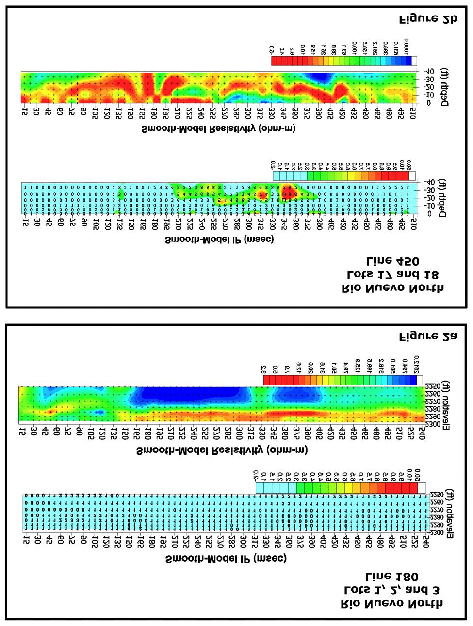
3 Data Quality: With recent improvements in electronics, the data quality and repeatability were extremely good. For example, Figure 1 shows a histogram of the agreement between repeated measurements along a line at the Los Reales Landfill, which is an active landfill in Tucson, Arizona, USA. Of the 1,162 data points along this line, the chargeability measurement on more than 99% of the data points repeated within 0.25 milliseconds. This excellent repeatability allows valid interpretation of very weak features, which has proven to be important in landfill delineation. Similarly, resistivity data along the same line repeated within 0.2 per cent at more than 99% of the data points. Data Examples: A comparison of data over a typical background area and an area subsequently proven to contain buried waste is shown in Figures 2a and 2b. Both lines of data are from the Rio Nuevo North Landfill project area in Tucson, Arizona, USA, and these lines are approximately 425 meters apart. Figure 2a shows the IP and resistivity cross sections (2-D smooth-model inversion results) for the background area (called Line 180). All IP values are less than 2 milliseconds, and resistivity data are relatively layered. In Figure 2b, however, an IP anomaly is clearly evident in the central portion of Line 450, and this area has since been confirmed as buried waste with approximately 3 meters of soil cover. Note also that the resistivity data are very irregular, and are not layered similar to Line 180. Historical photographs from the 1950s and 1960s of the Line 450 area indicate numerous pits and excavations from gravel operations. This relationship between subsurface characteristics (background, buried waste, disturbed areas) and IP/ resistivity data has been relatively consistent throughout all the landfills we have studied. Undisturbed background areas tend to show very small or no IP effects (<1 or 2 milliseconds) with layered or homogeneous resistivity. Disturbed areas with no subsurface waste tend to show very small or no IP effect also, but irregular resistivity (laterally and vertically). Areas of subsurface waste show well-defined IP anomalies (>3 milliseconds) and irregular resistivity. Thus both data sets are important in locating the subsurface waste and reconciling the geophysical data with historical records. A more extensive example of our results can be seen in the complete Rio Nuevo North Landfill case history. This site, covering approximately 9 hectares, provided a very interesting test of the IP method. Records of dumping activities were very poor, the area was extensively excavated at various times for sand and gravel operations, and the area had been haphazardly cleaned to a depth of approximately 5 meters during the 1980s. Thus there are numerous backfilled pits, some of which contain soil and some of which contain waste, and waste was suspected to be under more than 5 meters of cover in some areas. Portions of the site, which is in an urban environment, have already been developed, and the geophysical survey was intended to characterize the remaining, undeveloped lots.
4
5
 apart.")
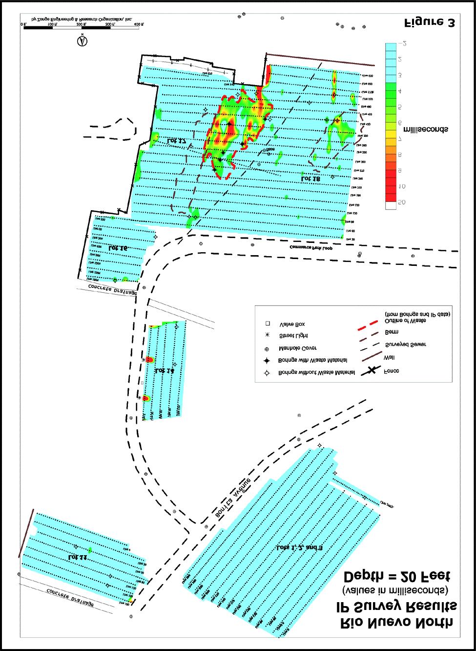
6 Figure 3 shows the IP results (2-D smooth-model inversion) in plan view for the entire site at a depth of 6.1 m (20 ft). These results are comprised of more than 14,000 data points at 3,767 stations along lines that were spaced 9.1 meters (30 ft) apart. IP anomalies attributed to waste were evident only on Lots 17 and 18, on the southern part of the site. Figure 4 shows the grid of data in more detail on Lots 17 and 18, with the interpreted waste outlined with a red dashed line. (Note that the interpreted outline of the waste is from the IP data at all depths, thus there is a slight discrepancy between the IP anomaly in Figure 4 at a depth of 6.1 meters and the outlined waste.) Subsequent borings confirmed the outline of the waste based on the IP data, as well as the thickness of soil cover (>4.5 meters for most the anomalous area). Some borings were positioned very close to the edge of the anomaly to verify the resolution of the IP data, and in all cases the IP data were confirmed. Outside of the anomaly attributed to waste, several other anomalous areas were identified. In some cases, these anomalies could be attributed to other cultural features; the linear anomaly in the southeastern part of the grid on Figure 4 is interpreted to be an old utility line, for example. A weak, shallow anomaly near the northwestern edge of the Figure 4 grid was drilled, but no waste was evident. This anomaly, and a small number of other small features, are attributed to possible clays or unknown cultural features.
7
 but that showed no IP anomalies.")
8 Drilling results for the entire site are summarized on Figure 5. All borings within the outline of the waste interpreted from the IP data did encounter waste. Several borings were positioned specifically to test areas likely to contain waste (based on historical records) but that showed no IP anomalies. For example, three boreholes were located on the southeast edge of Lot 3 because subsurface waste had previously been encountered during the construction of a restaurant adjacent to that lot. Drilling on the edge of Lot 3 did not encounter any waste, however, confirming the interpretation of the IP data. Similarly, none of the boreholes that were drilled in areas that showed background IP values (<3 milliseconds) encountered waste, regardless of the historical expectations. After the location of the waste had been delineated by the IP survey and confirmed by drilling, the area was also surveyed using a magnetometer and a boom-style conductivity system (EM- 31). Since no significant metal was encountered in the drilling, the magnetometer was not expected to delineate the subsurface waste. Only minor anomalies resulting from surface metal objects were evident in the magnetometer survey. The results of the conductivity survey (vertical coil orientation) are shown in Figure 6. There is no correlation between the conductivity results and the subsurface waste, probably due to the depth of the waste and the disturbed nature of the area as a whole. The conductivity results do agree relatively well with the 2-D smooth-model resistivity results (Figure 7), as expected, although the conductivity results fit best with the resistivity data at depths of 10 to 14 feet. This is somewhat shallower than expected, based on the coil orientation of the system.
, green waste (organics such as branches, wood, clippings, etc.), and some construction waste.")
9 Five other landfills have shown similar results, with IP anomalies consistently associated with buried subsurface waste. These landfills contain primarily municipal solid waste (household garbage), green waste (organics such as branches, wood, clippings, etc.), and some construction waste. At only one site was a significant amount of metal encountered in the borehole, indicating that the IP response can not be attributed solely to metallic debris. Conclusions: A large amount of data, with a significant number of confirmatory trenches and boreholes, indicates that buried waste material produces a measurable IP effect. Although the source mechanism(s) of the IP effect has not yet been established, it is evident that the IP response is not solely the result of metallic debris in the waste. In the research to date, this IP effect has been shown to be a more reliable indicator of subsurface waste than other geophysical methods such as conductivity or magnetics, and the depth of investigation of the IP method is significantly deeper than ground penetrating radar. With recent improvements in equipment allowing very fast data acquisition, the IP method is now an economic, non-intrusive method for determining the thickness of soil cover as well as the thickness of waste in buried landfills. Research continues into using the IP method for differentiation of types of waste.
SAGEEP. DoWN IN THE DUMPS. Workshop Notes
 Workshop Notes SAGEEP DoWN IN THE DUMPS Landfill characterization with an Extremely Fast IP Method March 15,1999 zonge engineering AND research organization 3322 e. fort lowell road. Tucson, AZ 85716 1-800-523-9913
THE UTILITY OF HORIZONTAL COMPONENT MEASUREMENTS IN RANDOM-WALK TEM SURVEYS. Abstract
 THE UTILITY OF HORIZONTAL COMPONENT MEASUREMENTS IN RANDOM-WALK TEM SURVEYS Norman R. Carlson, Zonge Engineering & Research Organization, Inc., Tucson, AZ Kenneth L. Zonge, Zonge Engineering & Research
Geophysical Exploration in Water Resources Assessment. John Mundell, P.E., L.P.G., P.G. Ryan Brumbaugh, L.P.G. Mundell & Associates, Inc.
 Geophysical Exploration in Water Resources Assessment John Mundell, P.E., L.P.G., P.G. Ryan Brumbaugh, L.P.G. Mundell & Associates, Inc. Presentation Objective Introduce the use of geophysical survey methods
USE OF GEOPHYSICAL SURVEYS FOR FILL CHARACTERIZATION AND QUANTITY ESTIMATION AT BROWNFIELD SITES A CASE HISTORY. Abstract
 USE OF GEOPHYSICAL SURVEYS FOR FILL CHARACTERIZATION AND QUANTITY ESTIMATION AT BROWNFIELD SITES A CASE HISTORY John A. Mundell, Mundell & Associates, Inc., Indianapolis, IN Gregory B. Byer, Mundell &
Geophysical Investigation of a 19th Century Archeological Site, Boston College K. Corcoran, J. Hager, M. Carnevale
 Geophysical Investigation of a 19th Century Archeological Site, Boston College K. Corcoran, J. Hager, M. Carnevale Hager GeoScience, Inc., Waltham, MA ------------------------------------------------------------------------
Applied Geophysics for Environmental Site Characterization and Remediation
 Applied Geophysics for Environmental Site Characterization and Remediation MSECA Webinar September 24, 2015 John Mundell, P.E., L.P.G. Ryan Brumbaugh, L.P.G. MUNDELL & ASSOCIATES, INC. Webinar Objective
Geophysics for Environmental and Geotechnical Applications
 Geophysics for Environmental and Geotechnical Applications Dr. Katherine Grote University of Wisconsin Eau Claire Why Use Geophysics? Improve the quality of site characterization (higher resolution and
1. Resistivity of rocks
 RESISTIVITY 1) Resistivity of rocks 2) General principles of resistivity surveying 3) Field procedures, interpretation and examples 4) Summary and conclusions INDUCED POLARIZATION 1) General principles
High Resolution Geophysics: A Better View of the Subsurface. By John Jansen, P.G., Ph.D., Aquifer Science and Technology
 High Resolution Geophysics: A Better View of the Subsurface By John Jansen, P.G., Ph.D., Aquifer Science and Technology Geologist Use Only Part of the Information Available To Them Most Geologist rely
ELECTRICAL RESISTIVITY SURVEYS AT THE ANDERSON RESIDENCE SITE, PORT CLYDE, ME. For: St.Germain-Collins
 ELECTRICAL RESISTIVITY SURVEYS AT THE ANDERSON RESIDENCE SITE, PORT CLYDE, ME For: St.Germain-Collins 4 Union Street, Suite 3 Bangor, Maine 441 July, 218 ELECTRICAL RESISTIVITY SURVEYS AT THE ANDERSON
EARLY-TIME, MULTI-COMPONENT MOBILE TEM FOR DEEP METAL DETECTION. Abstract
 EARLY-TIME, MULTI-COMPONENT MOBILE TEM FOR DEEP METAL DETECTION Norman R. Carlson and Kenneth L. Zonge Zonge Engineering & Research Organization, Inc., Tucson, AZ. Abstract Data examples from a recent
IMAGING OF DEEP SINKHOLES USING THE MULTI-ELECTRODE RESISTIVITY IMPLANT TECHNIQUE (MERIT) CASE STUDIES IN FLORIDA
 CASE STUDIES IN FLORIDA") IMAGING OF DEEP SINKHOLES USING THE MULTI-ELECTRODE RESISTIVITY IMPLANT TECHNIQUE (MERIT) CASE STUDIES IN FLORIDA David Harro The G3 Group, 2509 Success Drive, Suite 1, Odessa, FL 33556, david.harro@geo3group.com
IMAGING OF DEEP SINKHOLES USING THE MULTI-ELECTRODE RESISTIVITY IMPLANT TECHNIQUE (MERIT) CASE STUDIES IN FLORIDA David Harro The G3 Group, 2509 Success Drive, Suite 1, Odessa, FL 33556, david.harro@geo3group.com
KARST MAPPING WITH GEOPHYSICS AT MYSTERY CAVE STATE PARK, MINNESOTA
 KARST MAPPING WITH GEOPHYSICS AT MYSTERY CAVE STATE PARK, MINNESOTA By Todd A. Petersen and James A. Berg Geophysics Program Ground Water and Climatology Section DNR Waters June 2001 1.0 Summary A new
MOUNT POLLEY MINING CORPORATION TECHNICAL REPORT ON MULTI-ELECTRODE RESISTIVITY AND SEISMIC REFRACTION SURVEYS MOUNT POLLEY TAILINGS DAM PROJECT
 MOUNT PLEY MINING CORPORATION TECHNICAL REPORT ON MULTI-ELECTRODE RESISTIVITY AND SEISMIC REFRACTION SURVEYS MOUNT PLEY TAILINGS DAM PROJECT LIKELY, B.C. by Claudia Krumbiegel, M.Sc. Cliff Candy, P.Geo.
Geoelectrical Monitoring for Mapping of Gas and Water Migration in Landfills
 Geoelectrical Monitoring for Mapping of Gas and Water Migration in Landfills TORLEIF DAHLIN 1, HÅKAN ROSQVIST 2, SARA JOHANSSON 3, CARL-HENRIK MÅNSSON 3, MATS SVENSSON 3, MAGNUS LINDSJÖ 3 and MENG HENG
Use of Non-Invasive Near-Surface Geophysics for Managing Brine Releases
 Use of Non-Invasive Near-Surface Geophysics for Managing Brine Releases Presented by: Brent W. Barker, Staff Geophysicist Remediation Technologies Symposium 2012 Imagine the result Co-Authors Boyce L.
Geotechnical verification of impact compaction
 PII-73 Geotechnical verification of impact compaction P. J. Waddell1, R. A. Moyle2 & R. J. Whiteley1 1 2 Coffey Geotechnics, Sydney, Australia Coffey Geotechnics, Harrogate, UK Abstract Remediation of
GEOPHYSICAL SITE CHARACTERIZATION IN SUPPORT OF HIGHWAY EXPANSION PROJECT
 GEOPHYSICAL SITE CHARACTERIZATION IN SUPPORT OF HIGHWAY EXPANSION PROJECT * Shane Hickman, * Todd Lippincott, * Steve Cardimona, * Neil Anderson, and + Tim Newton * The University of Missouri-Rolla Department
TIME DOMAIN ELECTROMAGNETICS IN MARS ANALOG ENVIRONMENTS: COMPARING TWO FIELD STUDIES. Joern A. Jernsletten 1
 AAS 06-256 TIME DOMAIN ELECTROMAGNETICS IN MARS ANALOG ENVIRONMENTS: COMPARING TWO FIELD STUDIES Joern A. Jernsletten 1 The purpose of this study is to evaluate the use of (diffusive) Time Domain Electromagnetics
ERDC/GSL TN-14-1 August 2014 Electromagnetic Induction Survey of the Mississippi River in Cleveland, Mississippi
 Electromagnetic Induction Survey of the Mississippi River in Cleveland, Mississippi By Joseph B. Dunbar and Maureen K. Corcoran PURPOSE: This study was conducted in support of Mississippi State University
Ground Penetrating Radar Survey of a Portion of East End Cemetery, Cadiz, Kentucky
 Ground Penetrating Radar Survey of a Portion of East End Cemetery, Cadiz, Kentucky January 2011 Report prepared by Anthony L. Ortmann, Ph.D. Assistant Professor Department of Geosciences Murray State University
ambiguity in earth sciences IESO Geophysics Section Eddy hartantyo, Lab Geofisika FMIPA UGM
 ambiguity in earth sciences IESO Geophysics Section Eddy hartantyo, Lab Geofisika FMIPA UGM Pelatihan Tahap II IESO Teknik Geologi UGM Februari 2009 1 Introduction Photos from http://www.eegs.org/whatis/
MEMORANDUM. Interpretation of Magnetic and Volterra-3DIP survey MC Claims
 11966 95A Avenue, Delta, BC V4C 3W2 Canada Tel +1 (604) 582-1100 www.sjgeophysics.com MEMORANDUM Date: September 13, 2017 From: To: SUBJECT: E. Trent Pezzot Bonanza Mining Corporation Interpretation of
FINAL REPORT GEOPHYSICAL INVESTIGATION WATER TOWER NO. 6 SITE PLANT CITY, FL
 APPENDIX B FINAL REPORT GEOPHYSICAL INVESTIGATION WATER TOWER NO. 6 SITE PLANT CITY, FL Prepared for Madrid Engineering Group, Inc. Bartow, FL Prepared by GeoView, Inc. St. Petersburg, FL February 28,
Case Study: University of Connecticut (UConn) Landfill
 Landfill") Case Study: University of Connecticut (UConn) Landfill Problem Statement:» Locate disposal trenches» Identify geologic features and distinguish them from leachate and locate preferential pathways in fractured
Case Study: University of Connecticut (UConn) Landfill Problem Statement:» Locate disposal trenches» Identify geologic features and distinguish them from leachate and locate preferential pathways in fractured
GEOSYNTEC CONSULTANTS
 GEOSYNTEC CONSULTANTS 2100 Main Street, Suite 150 Huntington Beach, CA 92648 USA Tel (714) 969-0800 Fax (714) 969-0820 15 February 2006 Ms. Tamara Zeier, P.E. Project Manager Project Navigator, Ltd. One
Hamed Aber 1 : Islamic Azad University, Science and Research branch, Tehran, Iran. Mir Sattar Meshin chi asl 2 :
 Present a Proper Pattern for Choose Best Electrode Array Based on Geological Structure Investigating in Geoelectrical Tomography, in order to Get the Highest Resolution Image of the Subsurface Hamed Aber
GEOTECHNICAL ENGINEERING II. Subject Code : 06CV64 Internal Assessment Marks : 25 PART A UNIT 1
 GEOTECHNICAL ENGINEERING II Subject Code : 06CV64 Internal Assessment Marks : 25 PART A UNIT 1 1. SUBSURFACE EXPLORATION 1.1 Importance, Exploration Program 1.2 Methods of exploration, Boring, Sounding
Resistivity & IP methods
 International PhD Course in HYDROGEOPHYSICS Resistivity & IP methods Andrew Binley Lancaster University Overview We have demonstrated links between hydrological and geophysical properties and show the
Location of Abandoned Water Wells by Magnetic Surveys over the Edwards Aquifer in the San Antonio Area, Texas. Abstract. 1.
 Bulletin of the Location of Abandoned Water Wells by Magnetic Surveys over the Edwards Aquifer in the San Antonio Area, Texas Mustafa Saribudak 1, Alf Hawkins 1 and Roger Andrade 2 1 Environmental Geophysics
Geophysical Investigation of the Old Gaborone Dumpsite, Botswana SHEMANG, E M; MOLWALEFHE, L; CHAOKA, TR; MOSWEU E; NONDO, M
 JASEM ISSN 1119-8362 All rights reserved Full-text Available Online at www.bioline.org.br/ja J. Appl. Sci. Environ. Mgt. September, 2006 Vol. 10 (3) 87-92 Geophysical Investigation of the Old Gaborone
Tu 23P1 06 Mapping Possible Flowpaths of Contaminants through Surface and Cross-borehole Spectral Timedomain Induced Polarization
 Tu 23P1 06 Mapping Possible Flowpaths of Contaminants through Surface and Cross-borehole Spectral Timedomain Induced Polarization T. Bording* (Aarhus University), G. Fiandaca (Aarhus University), P.K.
Appendix B: Geophysical Data (Thesis Appendix, 2013)
") Utah State University From the SelectedWorks of David J Richey 2013 Appendix B: Geophysical Data (Thesis Appendix, 2013) David J Richey, Utah State University Available at: https://works.bepress.com/david_richey/2/
Utah State University From the SelectedWorks of David J Richey 2013 Appendix B: Geophysical Data (Thesis Appendix, 2013) David J Richey, Utah State University Available at: https://works.bepress.com/david_richey/2/
MAPPING STRUCTURAL PATHWAYS FOR DNAPL TRANSPORT IN KARST USING INDUCED POLARIZATION
 MAPPING STRUCTURAL PATHWAYS FOR DNAPL TRANSPORT IN KARST USING INDUCED POLARIZATION Larry J. Hughes, EnSafe Inc., Memphis, TN Norman R. Carlson, Zonge Engineering & Research Organization, Inc., Tucson,
Introducing the Stratagem EH4. Electrical Conductivity Imaging System Hybrid-Source Magnetotellurics
 Introducing the Stratagem EH4 Electrical Conductivity Imaging System Hybrid-Source Magnetotellurics Stratagem EH4 Hybrid-Source Magnetotellurics Frequency range of 10 Hz to 90k Hz Approx. depth of investigation
2-D Resistivity Study: The Horizontal Resolution Improvement by Introducing the Enhancing Horizontal Resolution (EHR) Technique
 Technique") Open Journal of Geology, 213, 3, 1-6 doi:1.4236/ojg.213.32b1 Published Online April 213 (http://www.scirp.org/journal/ojg) 2-D Resistivity Study: The Horizontal Resolution Improvement by Introducing the
Open Journal of Geology, 213, 3, 1-6 doi:1.4236/ojg.213.32b1 Published Online April 213 (http://www.scirp.org/journal/ojg) 2-D Resistivity Study: The Horizontal Resolution Improvement by Introducing the
CONTENTS 1. INTRODUCTION. 2. THE D.C. RESISTIVITY METHOD 2.1 Equipment 2.2 Survey Procedure 2.3 Data Reduction
 (i) CONTENTS 1. INTRODUCTION page 1 2. THE D.C. RESISTIVITY METHOD 2.1 Equipment 2.2 Survey Procedure 2.3 Data Reduction 3 3 3 3 3. GEOPHYSICAL RESULTS 3.1 General 3.2 Discussion 4 4 4 4. LIMITATIONS 5
Comparison of Two Geophysical Methods to Investigate Sand and Gravel Deposits, a Case Study in Chumphuang District, Nakhornratchasima, Thailand
 Australian Journal of Basic and Applied Sciences, 7(7): 761-767, 2013 ISSN 1991-8178 Comparison of Two Geophysical Methods to Investigate and Gravel Deposits, a Case Study in Chumphuang District, Nakhornratchasima,
Detailed Low-Induction-Number EM Sounding to 9-m Depth
 Detailed Low-Induction-Number EM Sounding to 9-m Depth Richard S. Taylor, Dualem Inc. J. Scott Holladay, Geosensors Inc. David Lalonde, Geosensors Inc. SAGEEP, Charleston SC, April 11 Copyright 11, Dualem
GEOPHYSICAL SURVEY OF BURIED WASTE AT THE IDAHO NATIONAL ENGINEERING AND ENVIRONMENTAL LABORATORY: A CASE STUDY
 GEOPHYSICAL SURVEY OF BURIED WASTE AT THE IDAHO NATIONAL ENGINEERING AND ENVIRONMENTAL LABORATORY: A CASE STUDY ABSTRACT M.C. Pfeifer, A. W. Glenn, G. E. Matthern* *Idaho National Engineering and Environmental
Electromagnetic Imaging (EMI) Representative Project Summaries
 Representative Project Summaries") Electromagnetic Imaging (EMI) Representative Project Summaries A Cost-Effective Tool for Site Characterization Marcellus Shale Water Group, LLC State College, PA Houston, TX Austin, TX Scanning the brain,
Electromagnetic Imaging (EMI) Representative Project Summaries A Cost-Effective Tool for Site Characterization Marcellus Shale Water Group, LLC State College, PA Houston, TX Austin, TX Scanning the brain,
'?a October 31, 1990 COMINCO LTD. EXPLORATION NTS: 93 G-6. Cariboo Mining Division. Latitude: 53 deg. 16' N Longitude: 123 deg.
 COMINCO LTD. EXPLORATION NTS: 93 G-6 WESTERN DISTR CT Cariboo Mining Division Latitude: 53 deg. 16' N Longitude: 123 deg. 13' W Work Dates: June 7-8, 1990 '?a October 31, 1990 D.J. Holcombe ....... A ASSESSMENT
First Technical Report Geophysical experiments near Kajiado town
 First Technical Report Geophysical experiments near Kajiado town Synthesis Report of First case study within the ISGEAG VIA Water project By: Michel Groen *), Harry Rolf **), and Ammon Muiti ***) *) Acacia
B029 2D and 3D Resistivity Imaging in an Investigation of Boulder Occurrence and Soil Depth in Glacial Till
 B029 2D and 3D Resistivity Imaging in an Investigation of Boulder Occurrence and Soil Depth in Glacial Till R. Wisen* (Lund University), F. Linders (Lund University) & T. Dahlin (Lund University) SUMMARY
Influence of Paleochannels on Seepage
 Study 4 Influence of Paleochannels on Seepage Public Draft 2014 Monitoring and Analysis Plan September 2013 August 2012 Influence of Paleochannels on Seepage 1. Statement of Need Historical maps, aerial
AND HORSEFLY PROSPECTS, N.W. BRITISH COLUMBIA NTS, 103H/ll, 14 FOR ATNA RESOURCES LTD DELTA GEOSCIENCE LTD
 AND HORSEFLY PROSPECTS, N.W. BRITISH COLUMBIA NTS, 103H/ll, 14 FOR ATNA RESOURCES LTD BY DELTA GEOSCIENCE LTD FE T A. HENDRICKSON, P.GEO. 1 . TABLE OF CONTENTS Introduction............. Page 1. Personnel..........
Geology 228/378 Applied and Environmental Geophysics Lecture 6. DC resistivity Surveys
 Geology 228/378 Applied and Environmental Geophysics Lecture 6 DC resistivity Surveys Direct current (DC) Resistivity. Introduction 2. Current flow in the ground 3. Schlumberger, Wenner, dipole-dipole,
IV. ENVIRONMENTAL IMPACT ANALYSIS G. GEOLOGY AND SOILS
 IV. ENVIRONMENTAL IMPACT ANALYSIS G. GEOLOGY AND SOILS The following section is a summary of the geotechnical report conducted for the proposed project. The Report of Geotechnical Investigation Proposed
APPENDIX B: REPORT ON GEOPHYSICAL SURVEY, JULY 1998
 APPENDIX B: REPORT ON GEOPHYSICAL SURVEY, JULY 1998 by Andy Payne Introduction A geophysical survey was carried out at Le Yaudet, Ploulec h, Brittany as part of the ongoing investigation into the archaeology
Sabal Trail Pipeline Project Evaluation of Karst Topography and Sinkhole Potential for Pipeline and Facilities
 November 11, 2014 Sabal Trail Pipeline Project Evaluation of Karst Topography and Sinkhole Potential for Pipeline and Facilities Gulf Interstate Engineering Attention: Mr. Denys Stavnychyi - Project Engineer
SEISMIC RADAR AND ELECTRICAL TECHNIQUES FOR WASTE DISPOSAL ASSESSMENT. M. Pipan, G. Dal Moro, E. Forte & M. Sugan
 SEISMIC RADAR AND ELECTRICAL TECHNIQUES FOR WASTE DISPOSAL ASSESSMENT M. Pipan, G. Dal Moro, E. Forte & M. Sugan Department of Geological, Environmental and Marine Sciences, University of Trieste Via Weiss,
LIST OF FIGURES APPENDICES
 RESISTIVITY / INDUCED POLARIZATION SURVEY EL PORVENIR PROJECT MUNICIPALITY OF REMEDIOS, ANTIOQUIA, COLOMBIA LOGISTICS REPORT M-17427 APRIL 2017 TABLE OF CONTENTS Abstract... 1 1. The Mandate... 2 2. El
Nanometrics Posthole Seismometers. World Class Performance
 Contents Summary... 3 Performance of the Trillium Posthole versus World Class Vault Instruments... 3 Variation in Noise with Depth... 3 Installation Examples... 4 Shallow Bedrock Installation... 4 Thick
DEEP GROUND-WATER EXPLORATION IN THE FLAGSTAFF, ARIZONA AREA USING CSAMT
 DEEP GROUND-WATER EXPLORATION IN THE FLAGSTAFF, ARIZONA AREA USING CSAMT Norman R. Carlson Zonge Engineering & Research Organization, Inc. 3322 E Fort Lowell Rd Tucson, Arizona 85716 Tel: (520)327-5501
Site characterization at the Groundwater Remediation Field Laboratory
 Site characterization at the Groundwater Remediation Field Laboratory WILLIAM P. C LEMENT, STEVE CARDIMONA, ANTHONY L. ENDRES, Boston College, Boston, Massachusetts KATHARINE KADINSKY-CADE, Phillips Laboratory,
MT Prospecting. Map Resistivity. Determine Formations. Determine Structure. Targeted Drilling
 MT Prospecting Map Resistivity Determine Formations Determine Structure Targeted Drilling Cross-sectional interpretation before and after an MT survey of a mineral exploration prospect containing volcanic
Lima Project: Seismic Refraction and Resistivity Survey. Alten du Plessis Global Geophysical
 Lima Project: Seismic Refraction and Resistivity Survey Alten du Plessis Global Geophysical Report no 0706/2006 18 December 2006 Lima Project: Seismic Refraction and Resistivity Survey by Alten du Plessis
Archaeology and Geophysics at the Chillicothe Site, Ohio, USA
 info@gemsys.on.ca Archaeology and Geophysics at the Chillicothe Site, Ohio, USA In this short paper, we summarize the recent procedings of the National Parks Service Archaeology Workshop in Chillicothe,
Consider a Geonics EM31 with the TX and RX dipoles a distance s = 3 m apart.
 E Near field, frequency domain EM systems E.1 EM responses of 1-D resistivity models E.1.1 Response of a halfspace Consider a Geonics EM31 with the TX and RX dipoles a distance s = 3 m apart. The TX and
Geophysics of Exploration for Water. Geoelectric methods III. edited by Peter Vass
 Geophysics of Exploration for Water Geoelectric methods III edited by Peter Vass The phenomenon of induced polarization was already noticed at the early stage of applying direct current electrical methods
Application of the RMT method
 Application of the RMT method Investigations of the landfill of industrial wastes by the RMT method The test site is the landfill of the coal ashes from power plants. The landfill was closed about 5 years
INTRODUCTION TO APPLIED GEOPHYSICS
 INTRODUCTION TO APPLIED GEOPHYSICS EXPLORING THE SHALL0W SUBSURFACE H. Robert Burger Anne F. Sheehan Craig H.Jones VERSITY OF COLORADO VERSITY OF COLORADO W. W. NORTON & COMPANY NEW YORK LONDON Contents
Electrical Surveying (part A)
") Electrical Surveying (part A) Dr. Laurent Marescot Course given at the University of Fribourg (2009) Contact: laurent@tomoquest.com www.tomoquest.com 1 Introduction Electrical surveying Resistivity method
Electrical Surveying (part A) Dr. Laurent Marescot Course given at the University of Fribourg (2009) Contact: laurent@tomoquest.com www.tomoquest.com 1 Introduction Electrical surveying Resistivity method
patersongroup Mineral Aggregate Assessment 3119 Carp Road Ottawa, Ontario Prepared For Mr. Greg LeBlanc March 7, 2014 Report: PH2223-REP.
 Geotechnical Engineering Environmental Engineering group Hydrogeology Geological Engineering Archaeological Studies Materials Testing 3119 Carp Road Prepared For Mr. Greg LeBlanc March 7, 2014 Paterson
Magnetics: Fundamentals and Parameter Extraction
 : Fundamentals and Parameter Extraction Stephen Billings Magnetic module outline fundamentals Sensor systems Data examples and demo Parameter extraction Concepts Real-world examples Classification Using
8 2 E L. Geophysical Exploration Report of 18282EL, Wase LGA, Plateau State. BRIGO MINING COMPANY LTD.
 1 Geophysical Exploration Report of 18282EL, Wase LGA, Plateau State. BRIGO MINING COMPANY LTD. 8 2 Electromagnetic and Induced Polarization Exploration Report 8 2 E L By: Dr. Oladele Olaniyan GISL, Abuja
Geological Mapping using Geophysics
 Geological Mapping using Geophysics Pugin, A.J.M. and T.H. Larson Illinois State Geological Survey, 615 E Peabody Dr., Champaign, IL 61820; E-mail: A.J.M. Pugin at pugin@isgs.uiuc.edu Mapping Techniques.
Gotechnical Investigations and Sampling
 Gotechnical Investigations and Sampling Amit Prashant Indian Institute of Technology Gandhinagar Short Course on Geotechnical Investigations for Structural Engineering 12 14 October, 2017 1 Purpose of
Geology 228/378 Applied & Environmental Geophysics Lecture 8. Induced Polarization (IP) and Nuclear Magnetic Resonance (NMR)
 and Nuclear Magnetic Resonance (NMR)") Geology 228/378 Applied & Environmental Geophysics Lecture 8 Induced Polarization (IP) and Nuclear Magnetic Resonance (NMR) Induced Polarization (IP) and Nuclear Magnetic Resonance (NMR) 1. Time domain
Geology 228/378 Applied & Environmental Geophysics Lecture 8 Induced Polarization (IP) and Nuclear Magnetic Resonance (NMR) Induced Polarization (IP) and Nuclear Magnetic Resonance (NMR) 1. Time domain
ACQUISITION, PROCESSING AND INTERPRETATION TECHNIQUES FOR GROUND-PENETRATING RADAR MAPPING OF BURIED PIT-STRUCTURES IN THE AMERICAN SOUTHWEST
 ACQUISITION, PROCESSING AND INTERPRETATION TECHNIQUES FOR GROUND-PENETRATING RADAR MAPPING OF BURIED PIT-STRUCTURES IN THE AMERICAN SOUTHWEST Lawrence B. Conyers Deparunent of Anthropology, University
Geophysical Survey Report
 Geophysical Survey Report Wickham Bushes, Bracknell, Berkshire for Thames Valley Archaeological Services December 2004 J1957 K T Donaldson Document Title: Client: Stratascan Job No: Techniques: Geophysical
ELECTRICAL RESISTIVITY SURVEY OF INTREPID POTASH INJECTION WELL SITE: EDDY COUNTY, NEW MEXICO
 NCKRI REPORT OF INVESTIGATION 3 ELECTRICAL RESISTIVITY SURVEY OF INTREPID POTASH INJECTION WELL SITE: EDDY COUNTY, NEW MEXICO www.nckri.org NATIONAL CAVE AND KARST RESEARCH INSTITUTE REPORT OF INVESTIGATION
POTASH DRAGON CHILE GEOPHYSICAL SURVEY TRANSIENT ELECTROMAGNETIC (TEM) METHOD. LLAMARA and SOLIDA PROJECTS SALAR DE LLAMARA, IQUIQUE, REGION I, CHILE
 METHOD. LLAMARA and SOLIDA PROJECTS SALAR DE LLAMARA, IQUIQUE, REGION I, CHILE") POTASH DRAGON CHILE GEOPHYSICAL SURVEY TRANSIENT ELECTROMAGNETIC (TEM) METHOD LLAMARA and SOLIDA PROJECTS SALAR DE LLAMARA, IQUIQUE, REGION I, CHILE OCTOBER 2012 CONTENT Page I INTRODUCTION 1 II FIELD
POTASH DRAGON CHILE GEOPHYSICAL SURVEY TRANSIENT ELECTROMAGNETIC (TEM) METHOD LLAMARA and SOLIDA PROJECTS SALAR DE LLAMARA, IQUIQUE, REGION I, CHILE OCTOBER 2012 CONTENT Page I INTRODUCTION 1 II FIELD
Sabal Trail Pipeline Project Evaluation of Karst Topography and Sinkhole Potential for Pipeline and Facilities
 November 11, 2014 Sabal Trail Pipeline Project Evaluation of Karst Topography and Sinkhole Potential for Pipeline and Facilities Gulf Interstate Engineering Attention: Mr. Denys Stavnychyi - Project Engineer
Engineer. Engineering. Engineering. (in-ja-neer ) A person trained and skilled in any of the various branches of engineering: a civil engineer
 A person trained and skilled in any of the various branches of engineering: a civil engineer") Engineer (in-ja-neer ) A person trained and skilled in any of the various branches of engineering: a civil engineer (Random House Webster s College Dictionary, 1991) CE100 Introduction to Civil Geotechnical
Engineer (in-ja-neer ) A person trained and skilled in any of the various branches of engineering: a civil engineer (Random House Webster s College Dictionary, 1991) CE100 Introduction to Civil Geotechnical
CHARACTERIZATION OF SOIL PROFILE OF DHAKA CITY USING ELECTRICAL RESISTIVITY TOMOGRAPHY (ERT)
") CHARACTERIZATION OF SOIL PROFILE OF DHAKA CITY USING ELECTRICAL RESISTIVITY TOMOGRAPHY (ERT) Mehedi Ahmed ANSARY 1, B.S. Pushpendue BISWAS 2 and Abul KHAIR 3 1 Professor, Department of Civil Engineering
CHARACTERIZATION OF SOIL PROFILE OF DHAKA CITY USING ELECTRICAL RESISTIVITY TOMOGRAPHY (ERT) Mehedi Ahmed ANSARY 1, B.S. Pushpendue BISWAS 2 and Abul KHAIR 3 1 Professor, Department of Civil Engineering
OPERATIVE GUIDE INDUCED POLARIZATION
 OPERATIVE GUIDE INDUCED POLARIZATION 1 Induced polarization geoelectric procedure Generals Induced polarization (capacitive effect) represents attitude of a material to collect electric charges of opposite
Report on the Geophysical survey undertaken at Kouphovouno between 28 th June and 2 nd July.
 Report on the Geophysical survey undertaken at Kouphovouno between 28 th June and 2 nd July. Introduction: A team comprising of two undergraduate students (Anna Moles & James Taylor) and two postgraduates
PRESENTATION TITLE. Drone Magnetic Site Surveys To Verify Wellhead Locations David M. Velozzi 9/27/18
 1 PRESENTATION TITLE Drone Magnetic Site Surveys To Verify Wellhead Locations David M. Velozzi 9/27/18 Speaker Information David M. Velozzi Geoscience Team Lead Magnetic Variation Services (MagVAR) (A
Chapter 12 Subsurface Exploration
 Page 12 1 Chapter 12 Subsurface Exploration 1. The process of identifying the layers of deposits that underlie a proposed structure and their physical characteristics is generally referred to as (a) subsurface
Geoelectricity. ieso 2010
 Geoelectricity ieso 2010 1 RESISTIVITY SURVEY AT VENETO VILLA GRITTI AT THE TOWN OF TREVISO (VENETO REGION) The survey was carried out to verify the underground presence of the fondations of a rustic building.
Figure 1: Location of principal shallow conductors at Alpala (anomalies C0-C10; 5 Ohm/m surfaces, red) and shallow zones of electrical chargeability
 and shallow zones of electrical chargeability") Figure 1: Location of principal shallow conductors at Alpala (anomalies C0-C10; 5 Ohm/m surfaces, red) and shallow zones of electrical chargeability (85 msecs, yellow-green) shown on iso-surfaces of MVI
Figure 1: Location of principal shallow conductors at Alpala (anomalies C0-C10; 5 Ohm/m surfaces, red) and shallow zones of electrical chargeability (85 msecs, yellow-green) shown on iso-surfaces of MVI
Lesson 1 Introduction to geophysical methods Emanuele Forte
 Lesson 1 Introduction to geophysical methods Emanuele Forte 3 rd September 2016 Naxos, Greece 1 Outline - What is Geophysics - Base concepts: (Geo)Physical parameters Sensitivity Resolution - Active and
ENCE 3610 Soil Mechanics. Site Exploration and Characterisation Field Exploration Methods
 ENCE 3610 Soil Mechanics Site Exploration and Characterisation Field Exploration Methods Geotechnical Involvement in Project Phases Planning Design Alternatives Preparation of Detailed Plans Final Design
Ground-Water Exploration in the Worthington Area of Nobles County: Summary of Seismic Data and Recent Test Drilling Results
 Ground-Water Exploration in the Worthington Area of Nobles County: Summary of Seismic Data and Recent Test Drilling Results Jim Berg and Todd Petersen Geophysicists, DNR Waters January 2000 Table of Contents
Amistad Dam Investigation and Oversight: Karst- Founded Dam on the USA-Mexico Border
 Amistad Dam Investigation and Oversight: Karst- Founded Dam on the USA-Mexico Border Brook Brosi, CPG, PG USACE Lisa Nowicki Perks, PG USACE Kimberly Heenan, PE AECOM US Army Corps of Engineers BUILDING
Hydrogeological Assessment for Part of Lots 2 and 3, Concession 5, Township of Thurlow, County of Hastings 1.0 INTRODUCTION. 1.
 February 10,2017 25506400 Ontario Ltd. Foxboro, ON Attention: Brad Newbatt Re: Hydrogeological Assessment for Part of Lots 2 and 3, Concession 5, Township of Thurlow, County of Hastings 1.0 INTRODUCTION
AN ARCHAEOLOGICAL SURVEY FOR THE EASTHAM STATE PRISON FARM UNIT PROJECT IN HOUSTON COUNTY TEXAS
 AN ARCHAEOLOGICAL SURVEY FOR THE EASTHAM STATE PRISON FARM UNIT PROJECT IN HOUSTON COUNTY TEXAS Antiquities Permit 5693 By William E. Moore and Edward P. Baxter Brazos Valley Research Associates Contract
The Efficacy of Enhancing Horizontal Resolution (EHR) Technique in Shallow Subsurface Study Using 2D Resistivity Method at Bukit Bunuh
 Technique in Shallow Subsurface Study Using 2D Resistivity Method at Bukit Bunuh") 212 International Conference on Geological and Environmental Sciences IPCBEE vol.3 6(212) (212)IACSIT Press, Singapoore The Efficacy of Enhancing Horizontal Resolution (EHR) Technique in Shallow Subsurface
212 International Conference on Geological and Environmental Sciences IPCBEE vol.3 6(212) (212)IACSIT Press, Singapoore The Efficacy of Enhancing Horizontal Resolution (EHR) Technique in Shallow Subsurface
A GPR ASSESSMENT OF THE PREHISTORIC NAPLES CANAL NAPLES, FLORIDA ARCHAEOLOGICAL AND HISTORICAL CONSERVANCY, INC.
 A GPR ASSESSMENT OF THE PREHISTORIC NAPLES CANAL NAPLES, FLORIDA ARCHAEOLOGICAL AND HISTORICAL CONSERVANCY, INC. AHC TECNICAL REPORT NO. 1004 DECEMBER 2013 A GPR ASSESSMENT OF THE PREHISTORIC NAPLES CANAL
FINAL REPORT GEOPHYSICAL INVESTIGATION VILLAGE ALHAMBRA RETENTION POND SITE THE VILLAGES, FLORIDA
 FINAL REPORT GEOPHYSICAL INVESTIGATION VILLAGE ALHAMBRA RETENTION POND SITE THE VILLAGES, FLORIDA Prepared for Andreyev Engineering, Inc. Oxford, FL Prepared by GeoView, Inc. St. Petersburg, FL August
Walkaway Seismic Experiments: Stewart Gulch, Boise, Idaho
 Walkaway Seismic Experiments: Stewart Gulch, Boise, Idaho Lee M. Liberty Center for Geophysical Investigation of the Shallow Subsurface Boise State University Boise, Idaho 1. Summary CGISS conducted walkaway
GEOPHYSICAL REPORT ON AN INDUCED POLAR.IZATION SURVEY
 GEOPHYSICAL REPORT ON AN INDUCED POLAR.IZATION SURVEY T & V Claim Groups some 12 miles Northwest of Babine Lake, B.C. Latitude 55' 26'N Longitude 126' 35'W AUTHOR: Glen E. White, Chief Geophysicist,a,
M E M O R A N D U M. Mr. Jonathan K. Thrasher, P.E. and Mr. Ian Kinnear, P.E. PSI
 M E M O R A N D U M TO: FROM: Mr. Mark Schilling Gulf Interstate Engineering Mr. Jonathan K. Thrasher, P.E. and Mr. Ian Kinnear, P.E. PSI DATE: November 11, 2014 RE: Summary of Findings Geotechnical Study
Case Study: Ground TEM survey over the Champagne deposit, Qc.
 Case Study: Ground TEM survey over the Champagne deposit, Qc. Circé Malo Lalande, Eng. Geophysicist www.gdd.ca Survey site Localisation Champagne deposit Bellechasse Gold Belt Golden Hope Mine ltd. 2 Exploration
Three-dimensional imaging of a deep marine channellevee/overbank sandstone behind outcrop with EMI and GPR
 THE METER READER Three-dimensional imaging of a deep marine channellevee/overbank sandstone behind outcrop with EMI and GPR RYAN P. STEPLER, ALAN J. WITTEN, and ROGER M. SLATT, University of Oklahoma,
We are committed to providing accessible customer service. If you need accessible formats or communications supports, please contact us.
 We are committed to providing accessible customer service. If you need accessible formats or communications supports, please contact us. Nous tenons à améliorer l accessibilité des services à la clientèle.
ELECTRICAL RESISTIVITY TOMOGRAPHY
 NOTIO Association Clay Technological Centre C/ Río Cabriel s/n 45007 Toledo Tel.: 925 24 11 62 info@notio.es www.notio.es Page 1 / 7 SUMMARY 1. PHYSICAL FUNDAMENTALS OF THE... 3 1.1. ELECTRICAL BEHAVIOR
a z41. COMMONWEALTH OF AUSTRALIA DEPARTMENT OF NATIONAL DEVELOPMENT BUREAU OF MINERAL RESOURCES, GEOLOGY AND GEOPHYSICS RECORD 1961 No.
 a z41. COMMONWEALTH OF AUSTRALIA ff..4 *.re /Veis DEPARTMENT OF NATIONAL DEVELOPMENT BUREAU OF MINERAL RESOURCES, GEOLOGY AND GEOPHYSICS RECORD 1961 No. 66 RED TANK BORE GRAVITY SURVEY, PLENTY RIVER, N.T.
Resistivity-IP mapping for landfill applications
 Resistivity-IP mapping for landfill applications With case studies from South Africa and Sweden, Torleif Dahlin, 1* Håkan Rosqvist 2 and Virginie Leroux 1 show how resistivity and time-domain induced polarization