Geology 228/378 Applied and Environmental Geophysics Lecture 6. DC resistivity Surveys
|
|
|
- Marianna Warren
- 5 years ago
- Views:
Transcription
1 Geology 228/378 Applied and Environmental Geophysics Lecture 6 DC resistivity Surveys
2 Direct current (DC) Resistivity. Introduction 2. Current flow in the ground 3. Schlumberger, Wenner, dipole-dipole, pole-dipole arrays 4. Field methods and instrumentation 5. Data interpretation 6. Field Examples


3 Ohm s Law (discovered in 827) V = IR Georg Simon Ohm ( )

4 It's Resistivity, NOT Resistance R = ρ = ρ L A RA L So the unit for resistivity is ohm-meter
5 For a point source in an infinity medium, we have the resistance R and potential V expressed as = = = = = = = S jds I r I r I IR V r r r A L R σ π π ρ π ρ π ρ ρ
6 Furthermore ρ = 4 π rv I or σ = 4 I π rv This resistivity is called the apparent resistivity. Only when the material is uniform, the apparent resisitivity is equal to the constant, real resistivity. ρ 4πrV 4πr V 4πr V = = = = a I ri I r 2 2 V jr
7 Most geophysical resistivity surveys have the measurements occurred at the surface of the earth. The air above the ground is literally an insulator (zero conductivity) and the current only flows in the ground. Thus, for calculating the current density on an equal-potential sphere, the surface area becomes from the closed spherical surface to the surface of the lower-hemisphere, and the potential changes to Electric field and current V = ρ 2 I π r I E = gradv = V J = σe = σ V r V
8 In practice, the field surveys usually measure the Voltage V, other than the potential itself. This voltage V is the difference of potential between 2 points. IN DC resistivity surveys the voltage is usually measured by two electrodes planted on the surface. ρ I ρ I V = V V 3 = I 2πr 2πr 3 r r 3 V V 3
. Thus, both the source and sink will generate an electric potential, but with opposite Dipole polarity.")
9 For the current can be physically flowing through the ground, we have to have 2 poles: one for current injected in (source) and one for the current flow out (sink). Thus, both the source and sink will generate an electric potential, but with opposite Dipole polarity. V V 2 = and 2 = ρ I π r 2 ρi πr 2 r r 2
10 And the total potential for the two poles is ) ( r r I r I r I V V V = = + = π ρ π ρ π ρ And the total voltage between two points generated by the two poles is ) ( 2 ) 2 2 ( ) 2 2 ( r r r r I r I r I r I r I V V V + = = + = π ρ π ρ π ρ π ρ π ρ


11
12 APPARENT RESISTIVITY because ) ( r r r r I V a + = π ρ I V k I V r r r r a = + = ) 2π ( ρ then
13 GEOMETRIC FACTOR K is the geometric factor that describes the geometry of the electrode configuration being used: A B M N V I = r r r r K π 2 + = NB AN MB AM K π

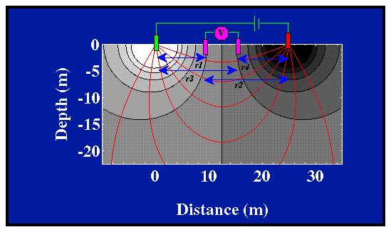
14 rr3 V ρ a = 2π ( ) r3 r I Pole-Dipole array
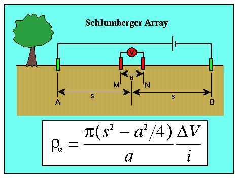
15 Schlumberger Array K = 2π CP C P 2 C P 2 + C P 2 2
16
17
( n + ) n V")
18 2l 2l(n-) 2l ρ a = 2πl ( n )( n + ) n V I
19 Data plotting
20 Dipole-Dipole Array
21 R, S : received, source signals G : geometrical spreading P S, P R : radiation pattern, receiver coupling L : propagating path
22 Pole pole Pole - dipole Dipole - dipole Wenner Schlumberger ELECTRODE ARRAYS
23 CHOICE OF THE BEST ARRAY Depends on: ) type of structure to be mapped 2) sensitivity of the resistivity meter 3) background noise level Things to be considered: ) depth of investigation 2) sensitivity of the array to vertical and horizontal structures 3) horizontal data coverage 4) signal strength.
24 DIPOLE-DIPOLE ADVANTAGES Low EM coupling between current and potential circuits Good for depth penetration High resolution and is sensitive to vertical resistivity boundaries (e.g. dykes and cavities)
25 DIPOLE-DIPOLE DISADVANTAGES Poor for vertical resolution of horizontal structures (e.g. sills or sedimentary layers) Data collected from dipole-dipole array are easily affected by near-surface resistivity variations and therefore can produce noisy data at sites with cultural relics Small signal strength for large values of n

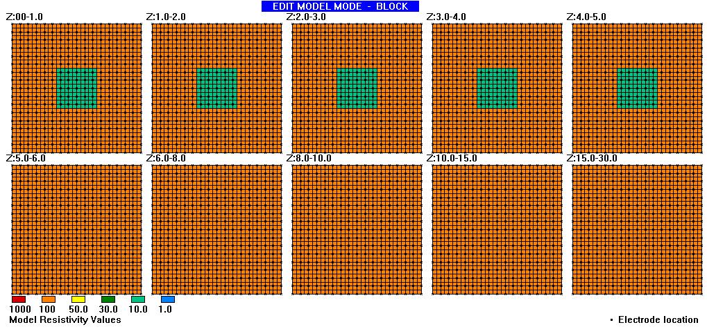
26 Apparent Resistivity Pseudo-section for a Block model

27 Wenner Pole-pole Dipole - dipole Pole-dipole Block model response

28 Near Surface Layer

29 Near Surface Layer Response, Plan View

30 Near Surface Layer Response, Pseudosection

31 Buried Vertical Contact

32 Buried Vertical Contact Response, Plan View

33 Buried Vertical Contact Response, Pseudosection
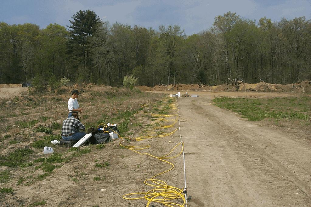
34 3D Prism

35 3D Prism Response, Plan View

36 3D Prism Response, Pseudosection

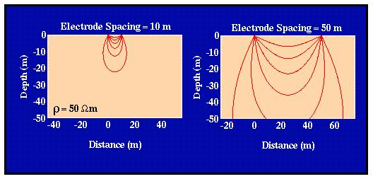
37 Pole-pole array sensitivity

38 Pole-dipole array sensitivity

39 Dipole-dipole array sensitivity

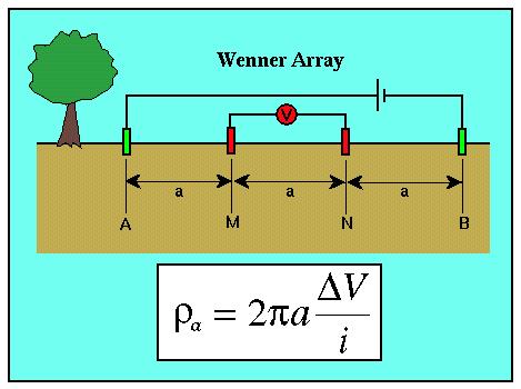
40 Wenner array sensitivity

41 Schlumberger array sensitivity
42 Resistivity Surveys
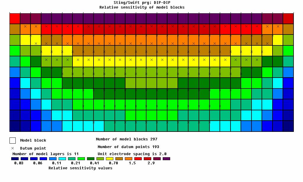
43

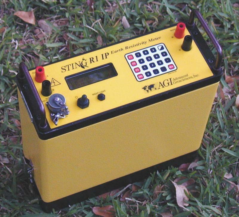
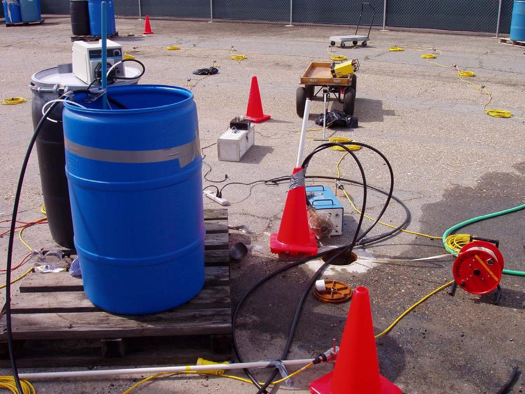
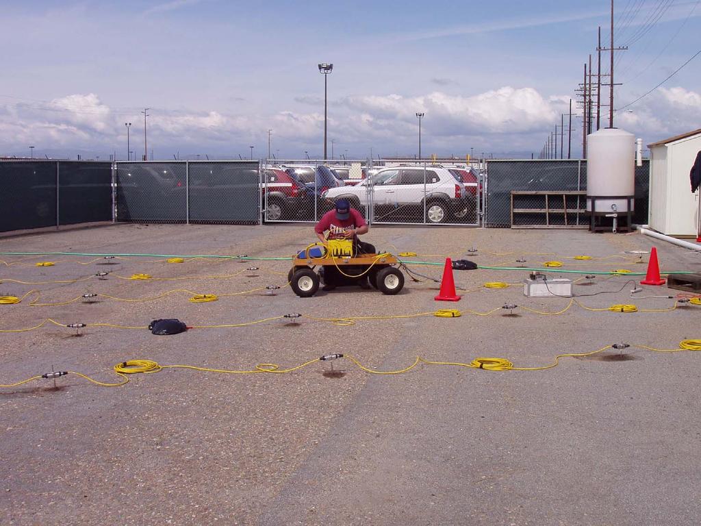
44 AGI Sting R- and the Swift automotive switchbox

45
46 DC Resistivity Interpretation R, S : received, source signals G : geometrical spreading P S, P R : radiation pattern, receiver coupling L : propagating path

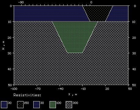
47 Electric current in layered media The current flow in the layered media deviates from that observed in the homogeneous media. In particular, notice that in the layered media the current flow lines are distorted in such a way that current preferentially seems to be attracted to the lower-resistivity portion of the layered media. In the model on the left, current appears to be pulled downward into the 50 ohm-m layer. In the model on the right, current appears to be bent upward, trying to remain within the lower resistivity layer at the top of the model. This shouldn't be surprising. What we are observing is the current's preference toward flowing through the path of least resistance. For the model on the left, that path is through the deep layer. For the model on the right, that path is through the shallow layer.
48
49
50
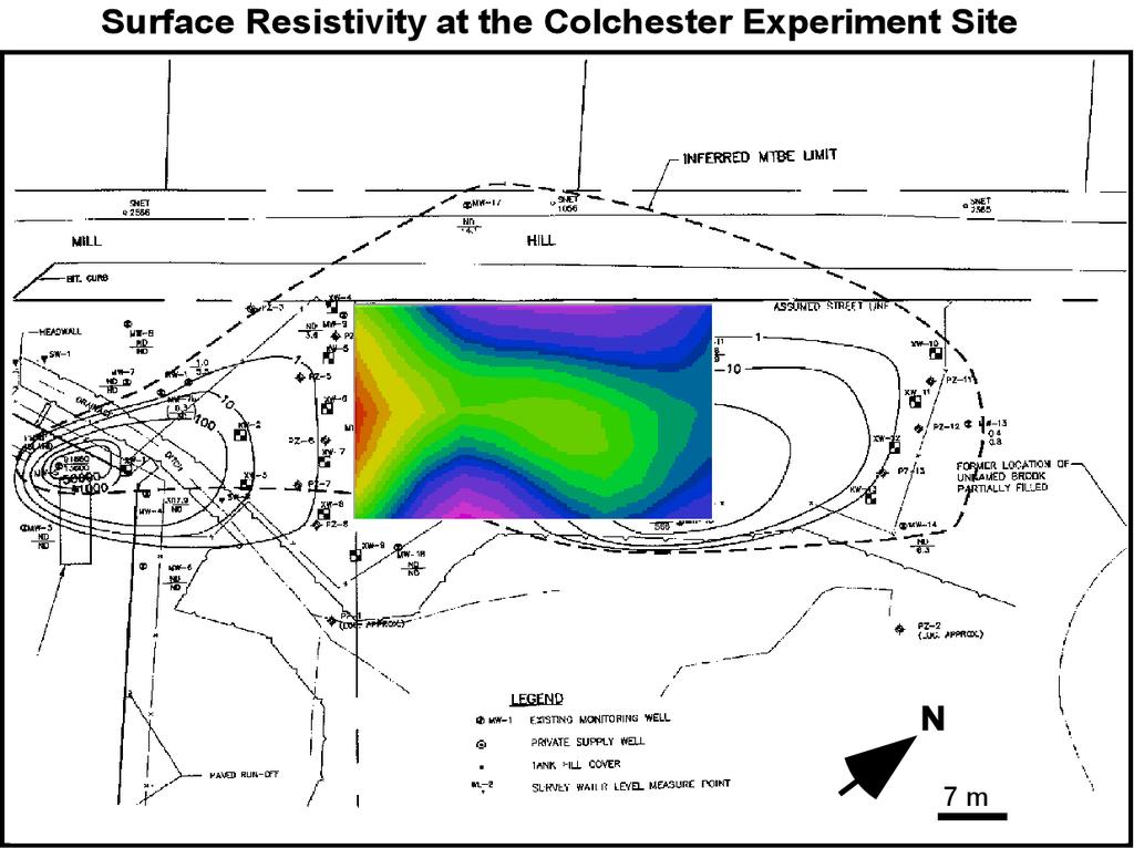
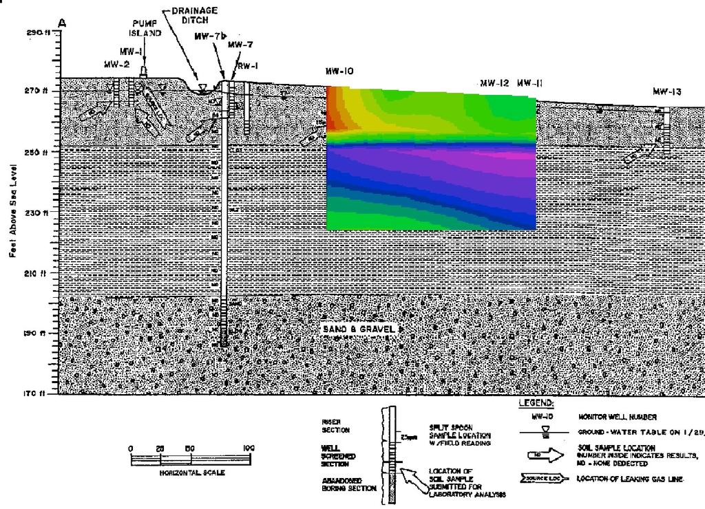
51
52 Sting/Swift prg: DIP-DIP title 2 unit electrode spacing 3 array No. dip-dip=3 93 No. of data points -middle point used 0 0-no IP st: apparent rho-location 2nd: PP2 spacing 3rd: dipole separation factor n 4th: apparent resistivity
53 DC Resistivity Interpretation R, S : received, source signals G : geometrical spreading P S, P R : radiation pattern, receiver coupling L : propagating path
54 CURRENT CONDUCTION IN ROCKS Electrolytic conduction occurs by the relatively slow movement of ions within an electrolyte Electronic conduction is the process by which metals, for example, allow electrons to move rapidly, so carrying the charge This is applicable in zero and low frequency case
55 crystalline rock can lead to low resistivities if they are filled with fluids. The resistivities of various earth materials are shown below. Material Resistivity (Ohm-meter) Air Pyrite 3 x 0^- Galena 2 x 0^-3 Quartz 4 x 0^0-2 x 0^4 Calcite x 0^2 - x 0^3 Rock Salt 30 - x 0^3 Mica 9 x 0^2 - x 0^4 Granite 00 - x 0^6 Gabbro x 0^3 - x 0^6 Basalt 0 - x 0^7 Limestones 50 - x 0^7 Sandstones - x 0^8 Shales 20-2 x 0^3 Dolomite 00-0,000 Sand -,000 Clay - 00 Ground Water Sea Water 0.2
56
57 Archie s law: In the ground, and in low frequencies, electricity is essentially conducted through the interstitial water in pores by ionic transport ρ = a φ m S n ρ w ρ effective formation resistivity; ρw pore water resistivity; φ porosity; S saturation; a ; m.3-2.5; n ~2.

 0 50 00 50 5")
58 EC Variation with Depth EC (micr omhos / cm)
59 EC Variation with Depth Cr Variation with Depth EC vs Cr EC (micromhos/cm) Cr (mg/l) y = x R 2 = Depth (ft) Depth (ft) C r ( m g /l) EC ( micromhos/cm) 25 25
60 DC Resistivity Case Studies = L ds R S e P P G S R ) ( ) ( ) ( ω α ω ω : propagating path receiver coupling radiation pattern, :, spreading : geometrical : received, source signals, L P P G S R R S
61
62
63
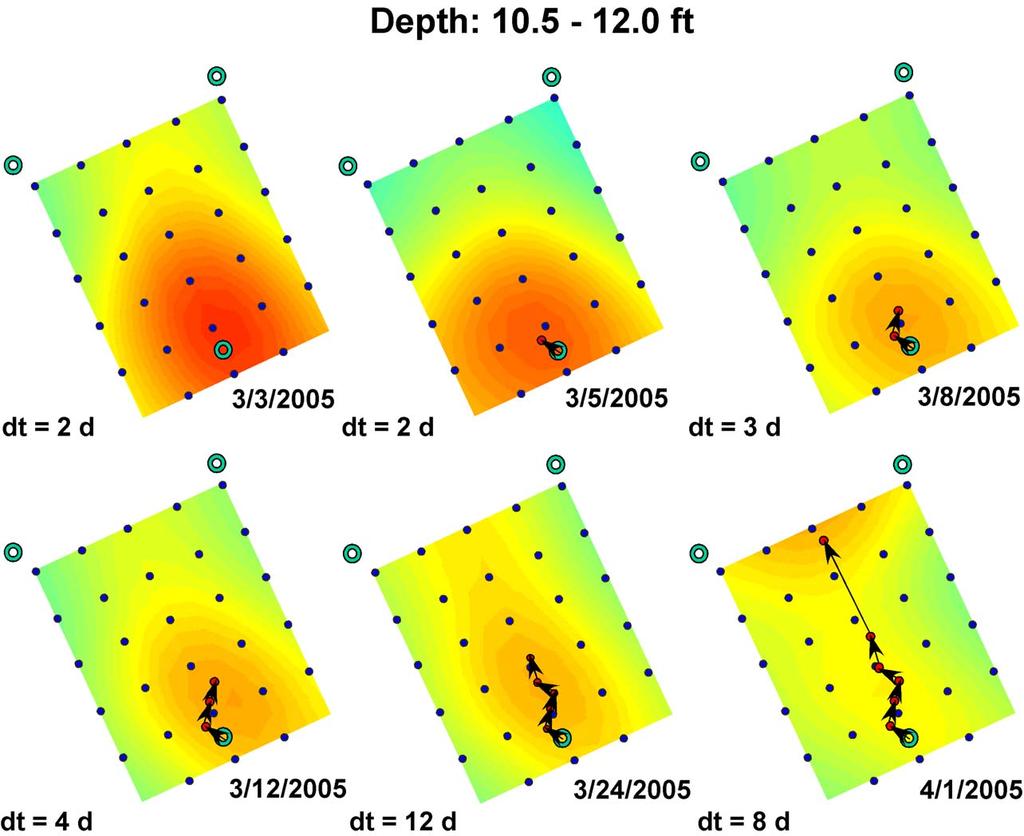
64
65

66

67 Detection of Saltwater Intrusion along the Noyo River, California

68 Resistivity and Seismic Survey Results
69 Piezocone GeoVIS Demonstration Plume Control and Containment System ESTCP LTM Test Cell NVBC Port Hueneme In-Situ BioBarrier (Mid Plume) NVBC Port Hueneme In-Situ BioBarrier (Leading Edge) GeoVIS/Piezocone Facility Patterson Rd. 23 rd Ave. N Pleasant Valley Rd. Pacific Ave. ESTCP NFESC/ASU In-Situ BioBarrier NEX Gas Station Site
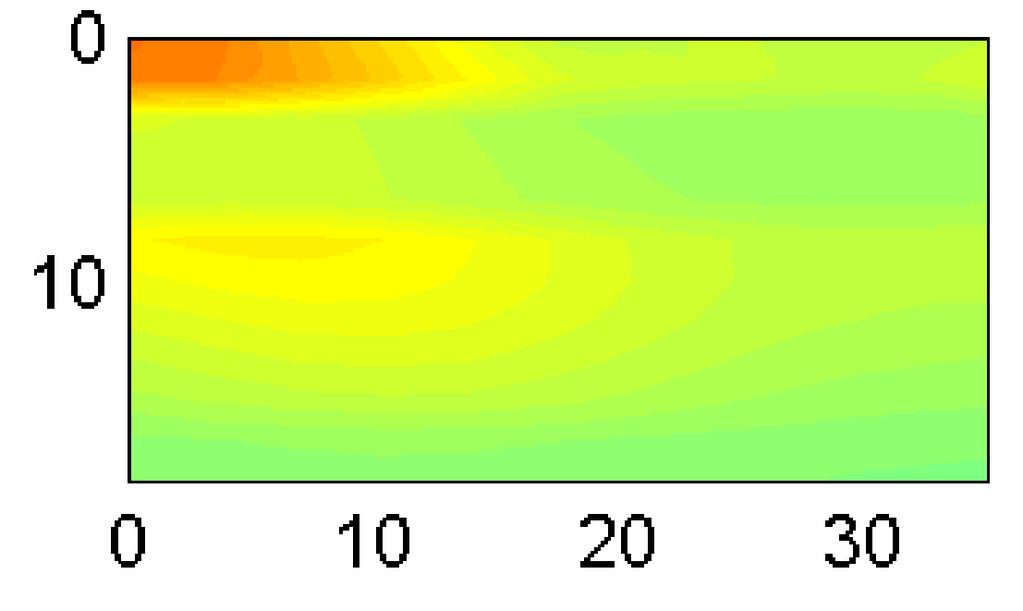
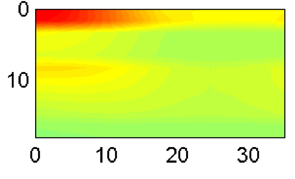
70 Electrode locations for DC resistivity Surveys East Lot of Building W3 7 W AGI Personnel Gate N Wells from previous extraction system Hydraulic Test Wells Proposed electrode location Utility Pole 20 Vehicle Gate 20 Vehicle Gate (Inject) W Water Storage Tanks Utility Shed Note: Layout displayed with 0 x 0 grid

71
72
73
74 2/28/2005

75 4//2005

76 4/ - 2/28, 2005
77
78


79 Day37 4 Day
80 .5 Z=2 ft DEC (S/m) Y distance (ft) Z=5 ft DEC (S/m) Y distance (ft)
81 Homework: The averaged electric conductivity of the groundwater found at the National Chromium site is about 00 microsiemens per centimeter.it is equivalent to 0 millisiemens per meter. The averaged formation conductivity found by the DC resistivity tomography is millisiemens per meter. By assuming the porosity is 35%, 00 % saturation, and a =.0, m=2.0 and by Archie s law, what is the estimated formation conductivity?
Electrical prospecting involves detection of surface effects produced by electrical current flow in the ground.
 Electrical Surveys in Geophysics Electrical prospecting involves detection of surface effects produced by electrical current flow in the ground. Electrical resistivity method Induced polarization (IP)
Geophysics Course Introduction to DC Resistivity
 NORAD supported project in MRRD covering Capacity Building and Institutional Cooperation in the field of Hydrogeology for Faryab Province Afghanistan Geophysics Course Introduction to DC Resistivity By
GLE 594: An introduction to applied geophysics
 GLE 594: An introduction to applied geophysics Electrical Resistivity Methods Fall 2004 Earth Properties and Basic Theory Reading Today : 207-218 Next Lecture : 218-228 1 Introduction Link resistivity
Definition. Useful References
 Introduction to Geophysics Short Course Assignments http://www.mines.edu/fs_home/tboyd/gp311/modules/res/main.html Definition Resistivity Method - Observation of electric fields caused by current introduced
Geoelectricity. ieso 2010
 Geoelectricity ieso 2010 1 RESISTIVITY SURVEY AT VENETO VILLA GRITTI AT THE TOWN OF TREVISO (VENETO REGION) The survey was carried out to verify the underground presence of the fondations of a rustic building.
Electrical Surveying (part A)
") Electrical Surveying (part A) Dr. Laurent Marescot Course given at the University of Fribourg (2009) Contact: laurent@tomoquest.com www.tomoquest.com 1 Introduction Electrical surveying Resistivity method
Electrical Surveying (part A) Dr. Laurent Marescot Course given at the University of Fribourg (2009) Contact: laurent@tomoquest.com www.tomoquest.com 1 Introduction Electrical surveying Resistivity method
1. Resistivity of rocks
 RESISTIVITY 1) Resistivity of rocks 2) General principles of resistivity surveying 3) Field procedures, interpretation and examples 4) Summary and conclusions INDUCED POLARIZATION 1) General principles
water L v i Chapter 4 Saturation
 4. Resistivity The presence of hydrocarbons is identified by the electrical resistance of the formation. These electrical properties of rocks depend on the pore geometry and fluid distribution. That is,
ELECTRICAL RESISTIVITY TOMOGRAPHY
 NOTIO Association Clay Technological Centre C/ Río Cabriel s/n 45007 Toledo Tel.: 925 24 11 62 info@notio.es www.notio.es Page 1 / 7 SUMMARY 1. PHYSICAL FUNDAMENTALS OF THE... 3 1.1. ELECTRICAL BEHAVIOR
CHARACTERIZATION OF SOIL PROFILE OF DHAKA CITY USING ELECTRICAL RESISTIVITY TOMOGRAPHY (ERT)
") CHARACTERIZATION OF SOIL PROFILE OF DHAKA CITY USING ELECTRICAL RESISTIVITY TOMOGRAPHY (ERT) Mehedi Ahmed ANSARY 1, B.S. Pushpendue BISWAS 2 and Abul KHAIR 3 1 Professor, Department of Civil Engineering
CHARACTERIZATION OF SOIL PROFILE OF DHAKA CITY USING ELECTRICAL RESISTIVITY TOMOGRAPHY (ERT) Mehedi Ahmed ANSARY 1, B.S. Pushpendue BISWAS 2 and Abul KHAIR 3 1 Professor, Department of Civil Engineering
ธรณ ฟ ส กส อ.ดร. ส ว มล อ ดพ วย
 205482 Geophysics ธรณ ฟ ส กส อ.ดร. ส ว มล อ ดพ วย E-mail: suwimons@hotmail.com Office: GB111-4 ภาคว ชาธรณ ว ทยา คณะว ทยาศาสตร มหาว ทยาล ยเช ยงใหม มหาวทยาลยเชยงใหม GEOPHYSICS Physics of the earth = applies
KARST MAPPING WITH GEOPHYSICS AT MYSTERY CAVE STATE PARK, MINNESOTA
 KARST MAPPING WITH GEOPHYSICS AT MYSTERY CAVE STATE PARK, MINNESOTA By Todd A. Petersen and James A. Berg Geophysics Program Ground Water and Climatology Section DNR Waters June 2001 1.0 Summary A new
Hamed Aber 1 : Islamic Azad University, Science and Research branch, Tehran, Iran. Mir Sattar Meshin chi asl 2 :
 Present a Proper Pattern for Choose Best Electrode Array Based on Geological Structure Investigating in Geoelectrical Tomography, in order to Get the Highest Resolution Image of the Subsurface Hamed Aber
4.6 DC resistivity and IP field systems, data processing and interpretation
 4.6 DC resistivity and P field systems, data processing and interpretation Electrode arrays Response of a layered earth The anisotropic half space Response of simple inhomogeneities Solutions for arbitrary
Introduction. Electrical surveying. Resistivity method Induced polarization method (IP) Self-potential (SP) method
 Self-potential (SP) method") Introduction Electrical surveying Resistivity method Induced polarization method (IP) Self-potential (SP) method Higher frequency methods (electromagnetic surveys): Electromagnetic induction methods Ground
Introduction Electrical surveying Resistivity method Induced polarization method (IP) Self-potential (SP) method Higher frequency methods (electromagnetic surveys): Electromagnetic induction methods Ground
Resistivity & IP methods
 International PhD Course in HYDROGEOPHYSICS Resistivity & IP methods Andrew Binley Lancaster University Overview We have demonstrated links between hydrological and geophysical properties and show the
I) Resistivity. Literatur: Telford, Geldart und Sheriff (1990): Applied Geophysics, Second Edition, Cambridge University Press, NY.
 Resistivity. Literatur: Telford, Geldart und Sheriff (1990): Applied Geophysics, Second Edition, Cambridge University Press, NY.") I) Resistivity Literatur: Telford, Geldart und Sheriff (1990): Applied Geophysics, Second Edition, Cambridge University Press, NY. Bender, F. (Hg.) (1985): Angewandte Geowissenschaften, Bd. II, Enke Verlag,
I) Resistivity Literatur: Telford, Geldart und Sheriff (1990): Applied Geophysics, Second Edition, Cambridge University Press, NY. Bender, F. (Hg.) (1985): Angewandte Geowissenschaften, Bd. II, Enke Verlag,
CONTENTS 1. INTRODUCTION. 2. THE D.C. RESISTIVITY METHOD 2.1 Equipment 2.2 Survey Procedure 2.3 Data Reduction
 (i) CONTENTS 1. INTRODUCTION page 1 2. THE D.C. RESISTIVITY METHOD 2.1 Equipment 2.2 Survey Procedure 2.3 Data Reduction 3 3 3 3 3. GEOPHYSICAL RESULTS 3.1 General 3.2 Discussion 4 4 4 4. LIMITATIONS 5
Electrical Methods. Resistivity Surveying
 Electrical Methods Resistivity Surveying Geologic Resistivity 1101 Resistivity surveying investigates variations of electrical resistance, by causing an electrical current to flow through the subsurface
MOUNT POLLEY MINING CORPORATION TECHNICAL REPORT ON MULTI-ELECTRODE RESISTIVITY AND SEISMIC REFRACTION SURVEYS MOUNT POLLEY TAILINGS DAM PROJECT
 MOUNT PLEY MINING CORPORATION TECHNICAL REPORT ON MULTI-ELECTRODE RESISTIVITY AND SEISMIC REFRACTION SURVEYS MOUNT PLEY TAILINGS DAM PROJECT LIKELY, B.C. by Claudia Krumbiegel, M.Sc. Cliff Candy, P.Geo.
Applied Geophysics for Environmental Site Characterization and Remediation
 Applied Geophysics for Environmental Site Characterization and Remediation MSECA Webinar September 24, 2015 John Mundell, P.E., L.P.G. Ryan Brumbaugh, L.P.G. MUNDELL & ASSOCIATES, INC. Webinar Objective
2-D Resistivity Study: The Horizontal Resolution Improvement by Introducing the Enhancing Horizontal Resolution (EHR) Technique
 Technique") Open Journal of Geology, 213, 3, 1-6 doi:1.4236/ojg.213.32b1 Published Online April 213 (http://www.scirp.org/journal/ojg) 2-D Resistivity Study: The Horizontal Resolution Improvement by Introducing the
Open Journal of Geology, 213, 3, 1-6 doi:1.4236/ojg.213.32b1 Published Online April 213 (http://www.scirp.org/journal/ojg) 2-D Resistivity Study: The Horizontal Resolution Improvement by Introducing the
Surface and borehole electrical resistivity tomography
 Surface and borehole electrical resistivity tomography Laurent Marescot laurent@tomoquest.com Introduction Surface electrical resistivity surveying is based on the principle that the distribution of electrical
OPERATIVE GUIDE INDUCED POLARIZATION
 OPERATIVE GUIDE INDUCED POLARIZATION 1 Induced polarization geoelectric procedure Generals Induced polarization (capacitive effect) represents attitude of a material to collect electric charges of opposite
Geophysical Exploration in Water Resources Assessment. John Mundell, P.E., L.P.G., P.G. Ryan Brumbaugh, L.P.G. Mundell & Associates, Inc.
 Geophysical Exploration in Water Resources Assessment John Mundell, P.E., L.P.G., P.G. Ryan Brumbaugh, L.P.G. Mundell & Associates, Inc. Presentation Objective Introduce the use of geophysical survey methods
Reservoir Rock Properties COPYRIGHT. Sources and Seals Porosity and Permeability. This section will cover the following learning objectives:
 Learning Objectives Reservoir Rock Properties Core Sources and Seals Porosity and Permeability This section will cover the following learning objectives: Explain why petroleum fluids are found in underground
LECTURE 10. Module 3 : Field Tests in Rock 3.6 GEOPHYSICAL INVESTIGATION
 LECTURE 10 3.6 GEOPHYSICAL INVESTIGATION In geophysical methods of site investigation, the application of the principles of physics are used to the study of the ground. The soil/rock have different characteristics
Module for: Resistivity Theory (adapted/modified from lectures in PETE 321 (Jensen/Ayers))
)") (PETE 663 Formation Evaluation and the Analysis of Reservoir Performance (Fall 2003)) Module for: Resistivity Theory (adapted/modified from lectures in PETE 321 (Jensen/Ayers)) J. L. Jensen W.B. Ayers
(PETE 663 Formation Evaluation and the Analysis of Reservoir Performance (Fall 2003)) Module for: Resistivity Theory (adapted/modified from lectures in PETE 321 (Jensen/Ayers)) J. L. Jensen W.B. Ayers
Practice Test Rocks and Minerals. Name. Page 1
 Name Practice Test Rocks and Minerals 1. Which rock would be the best source of the mineral garnet? A) basalt B) limestone C) schist D) slate 2. Which mineral is mined for its iron content? A) hematite
Geophysics for Environmental and Geotechnical Applications
 Geophysics for Environmental and Geotechnical Applications Dr. Katherine Grote University of Wisconsin Eau Claire Why Use Geophysics? Improve the quality of site characterization (higher resolution and
EXTREMELY FAST IP USED TO DELINEATE BURIED LANDFILLS. Norman R. Carlson, Cris Mauldin Mayerle, and Kenneth L. Zonge
 EXTREMELY FAST IP USED TO DELINEATE BURIED LANDFILLS Norman R. Carlson, Cris Mauldin Mayerle, and Kenneth L. Zonge Zonge Engineering and Research Organization, Inc. 3322 East Fort Lowell Road Tucson, Arizona,
Geophysics of Exploration for Water. Geoelectric methods III. edited by Peter Vass
 Geophysics of Exploration for Water Geoelectric methods III edited by Peter Vass The phenomenon of induced polarization was already noticed at the early stage of applying direct current electrical methods
ELECTRICAL PROSPECTING METHODS
 Suez Canal University Faculty of Science Department of Geology ELECTRICAL PROSPECTING METHODS Prepared By El-Arabi Hendi Shendi Professor of applied & environmental Geophysics 2008 1 CONTENTS Definitions
The Preliminary Study of Meteorite Impact Crater at Bukit Bunuh, Lenggong
 2012 International Conference on Geological and Environmental Sciences IPCBEE vol.3 6(2012) (2012)IACSIT Press, Singapoore The Preliminary Study of Meteorite Impact Crater at Bukit Bunuh, Lenggong A. H.
Geophysics Course Interpreting DC Resistivity Data
 NORAD supported project in MRRD covering Capacity Building and Institutional Cooperation in the field of Hydrogeology for Faryab Province Afghanistan Geophysics Course Interpreting DC Resistivity Data
Groundwater Resource Evaluation in Support of Dewatering a South Carolina Limestone Quarry
 Groundwater Resource Evaluation in Support of Dewatering a South Carolina Limestone Quarry Daniel T. Brantley 1, John M. Shafer 2, and Michael G. Waddell 3 AUTHORS: 1 Research Associate, Earth Sciences
GY 402: Sedimentary Petrology
 UNIVERSITY OF SOUTH ALABAMA GY 402: Sedimentary Petrology Lecture 27: Introduction to Wireline Log Interpretations Instructor: Dr. Douglas W. Haywick Last Time Carbonate Diagenesis Diagenesis 0.5 mm PPL
GRAVITY AND GRAVITY ANOMALIES Newtonian Gravitation
 Gravity Exploration GRAVITY AND GRAVITY ANOMALIES Newtonian Gravitation Gravity: force of attraction between objects with mass Consider two objects with mass m 1 and m 2 : m 1 m 2 F g F g distance (r)
Verification and Validation Calculations Using the STAR Geophysical Postprocessor Suite
 SAIC-03/1040 Final Report Verification and Validation Calculations Using the STAR Geophysical Postprocessor Suite Prepared by: J. W. Pritchett December 2003 Verification and Validation Calculations Using
Site Characterization & Hydrogeophysics
 Site Characterization & Hydrogeophysics (Source: Matthew Becker, California State University) Site Characterization Definition: quantitative description of the hydraulic, geologic, and chemical properties
Chapter 10. Chapter Rocks and the Rock Cycle. Rocks. Section 1 Rocks and the Rock Cycle
 Chapter 10 Rocks 1 Chapter 10 Section 1 Rocks and the Rock Cycle 2 10.1 Rocks and the Rock Cycle Magma is the parent material for all rocks. Once the magma cools and hardens, many changes can occur. Geology:
APPLICATION OF ELECTRICAL RESISTIVITY TOMOGRAPHY FOR SAND UNDERWATER EXTRACTION
 International Scientific Conference GEOBALCANICA 2018 APPLICATION OF ELECTRICAL RESISTIVITY TOMOGRAPHY FOR SAND UNDERWATER EXTRACTION Maya Grigorova Ivaylo Koprev University of Mining and Geology St. Ivan
Environmental and Exploration Geophysics I. Resistivity II tom.h.wilson
 Environmental and Exploration Geophysics I Resistivity II tom.h.wilson tom.wilson@mail.wvu.edu Department of Geology and Geography West irginia University Morgantown, W For next class complete in-class
Earth Resistance and Calculation of Earthing
 University of Ljubljana Faculty of Electrical Engineering Earth Resistance and Calculation of Earthing Seminar paper at subject Distribution and Industrial Systems Student: Mentor: Prof. dr. Grega Bizjak
Formation Evaluation: Logs and cores
 These powerpoint files were produced for the Earth History class at the Free University Berlin, Department of Geological Sciences The copyright for texts, graphical elements, and images lies with C. Heubeck,
Geology 228/278 Applied and Environmental Geophysics Lecture 3. Physical properties of earth materials in near-surface environment
 Geology 228/278 Applied and Environmental Geophysics Lecture 3 Physical properties of earth materials in near-surface environment Outline 1. Introduction 2. Mechanical properties 3. electrical properties:
THE UNIVERSITY OF TRINIDAD & TOBAGO
 THE UNIVERSITY OF TRINIDAD & TOBAGO B. A. SC. PETROLEUM ENGINEERING ALTERNATE 2012 FINAL EXAMINATIONS Course Code and Title: Programme: DATE: DURATION: FMEV 2002 - BASIC WELL LOGGING BASc B.A.SC. Petroleum
FINAL REPORT GEOPHYSICAL INVESTIGATION VILLAGE ALHAMBRA RETENTION POND SITE THE VILLAGES, FLORIDA
 FINAL REPORT GEOPHYSICAL INVESTIGATION VILLAGE ALHAMBRA RETENTION POND SITE THE VILLAGES, FLORIDA Prepared for Andreyev Engineering, Inc. Oxford, FL Prepared by GeoView, Inc. St. Petersburg, FL August
Groundwater Sustainability at Wadi Al Bih Dam, Ras El Khaimah, United Arab Emirates (UAE) using Geophysical methods
 using Geophysical methods") Groundwater Sustainability at Wadi Al Bih Dam, Ras El Khaimah, United Arab Emirates (UAE) using Geophysical methods Ahmed Murad, Amir Gabr, Saber Mahmoud, Hasan Arman & Abdulla Al Dhuhoori Geology Department
Groundwater Sustainability at Wadi Al Bih Dam, Ras El Khaimah, United Arab Emirates (UAE) using Geophysical methods Ahmed Murad, Amir Gabr, Saber Mahmoud, Hasan Arman & Abdulla Al Dhuhoori Geology Department
Department of Geophysics Faculty of Earth Sciences King Abdulaziz University
 Department of Geophysics Faculty of Earth Sciences King Abdulaziz University Dr. Mansour A. Al-Garni Office: room 233/Buld. 27 OR Dept. chair office/buld. 55 Introduction to Geophysics EGP 211 Time: 10-10:55
Chapter 12 Lecture. Earth: An Introduction to Physical Geology. Eleventh Edition. Earth s Interior. Tarbuck and Lutgens Pearson Education, Inc.
 Chapter 12 Lecture Earth: An Introduction to Physical Geology Eleventh Edition Earth s Interior Tarbuck and Lutgens Earth s Internal Structure Earth s interior can be divided into three major layers defined
Magnetic and Gravity Methods for Geothermal Exploration
 Magnetic and Gravity Methods for Geothermal Exploration Dr. Hendra Grandis Geophysics - ITB method and survey procedure Aero- or ground magnetic (covers a large area) Schlumberger resistivity mapping and
DOWN-HOLE SEISMIC SURVEY AND VERTICAL ELECTRIC SOUNDINGS RABASKA PROJECT, LÉVIS, QUÉBEC. Presented to :
 DOWN-HOLE SEISMIC SURVEY AND VERTICAL ELECTRIC SOUNDINGS RABASKA PROJECT, LÉVIS, QUÉBEC Presented to : TERRATECH 455, René-Lévesque Blvd. West Montreal, Québec HZ 1Z3 Presented by : GEOPHYSICS GPR INTERNATIONAL
As compaction and cementation of these sediments eventually occur, which area will become siltstone? A) A B) B C) C D) D
 A B) B C) C D) D") 1. A student obtains a cup of quartz sand from a beach. A saltwater solution is poured into the sand and allowed to evaporate. The mineral residue from the saltwater solution cements the sand grains together,
1. A student obtains a cup of quartz sand from a beach. A saltwater solution is poured into the sand and allowed to evaporate. The mineral residue from the saltwater solution cements the sand grains together,
Subsurface Characterization using Electrical Resistivity(Dipole-Dipole) method at Lagos State University (LASU) Foundation School, Badagry
 method at Lagos State University (LASU) Foundation School, Badagry") Available online at www.pelagiaresearchlibrary.com Advances in Applied Science Research, 2010, 1 (1): 174-181 Subsurface Characterization using Electrical Resistivity(Dipole-Dipole) method at Lagos State
Available online at www.pelagiaresearchlibrary.com Advances in Applied Science Research, 2010, 1 (1): 174-181 Subsurface Characterization using Electrical Resistivity(Dipole-Dipole) method at Lagos State
Short guide for resistivity and induced polarization tomography
 Short guide for resistivity and induced polarization tomography Address of the manufacturer: GF Instruments, s.r.o. Purkyňova 144 61200 Brno tel: +420 549 522 919 fax: +420 549 522 915 e-mail: info@gfinstruments.cz
Azimuthal Resistivity to Characterize Fractures in a Glacial Till. Mark Boris, University of Saskatchewan Jim Merriam, University of Saskatchewan
 Azimuthal Resistivity to Characterize Fractures in a Glacial Till Mark Boris, University of Saskatchewan Jim Merriam, University of Saskatchewan Abstract Azimuthal resistivity was used to characterize
15. MATHEMATICAL ALGORITHMS
 15. MATHEMATICAL ALGORITHMS 15.1 STANDARD ERROR OF THE MEAN (SEM)... 2 15.2 3-POINT DECOUPLING... 3 15.3 A NOTE ON RESISTIVITY CALCULATIONS... 4 15.4 RESISTIVITY CALCULATIONS... 4 DIPOLE - DIPOLE...4 POLE
Case Study: University of Connecticut (UConn) Landfill
 Landfill") Case Study: University of Connecticut (UConn) Landfill Problem Statement:» Locate disposal trenches» Identify geologic features and distinguish them from leachate and locate preferential pathways in fractured
Case Study: University of Connecticut (UConn) Landfill Problem Statement:» Locate disposal trenches» Identify geologic features and distinguish them from leachate and locate preferential pathways in fractured
325 C3 Electric current flow in a two-layer Earth
 35 C3 Electric current flow in a two-layer Earth C3.1 The effect of an interface To compute the apent resistivity of a multi-layer Earth, we must consider what will happen when electric current crosses
The objective of a grounding system are: 1. To provide safety to personnel during normal and fault conditions by limiting step and touch potential.
 GROUNDING SYSTEMS Part 1 Professor Ahdab Elmorshedy 1 Reference: High Voltage Engineering Theory and Practice, Text Book, Marcel Dekker Inc. NY, USA, 2000. Mazen Abdel-Salam, Hussein Anis, Ahdab Elmorshedy,
Environmental and Exploration Geophysics I. Resistivity II tom.h.wilson
 Environmental and Exploration Geophysics I Resistivity II tom.h.wilson tom.wilson@mail.wvu.edu Department of Geology and Geography West irginia University Morgantown, W Objectives for the day Review basic
The Efficacy of Enhancing Horizontal Resolution (EHR) Technique in Shallow Subsurface Study Using 2D Resistivity Method at Bukit Bunuh
 Technique in Shallow Subsurface Study Using 2D Resistivity Method at Bukit Bunuh") 212 International Conference on Geological and Environmental Sciences IPCBEE vol.3 6(212) (212)IACSIT Press, Singapoore The Efficacy of Enhancing Horizontal Resolution (EHR) Technique in Shallow Subsurface
212 International Conference on Geological and Environmental Sciences IPCBEE vol.3 6(212) (212)IACSIT Press, Singapoore The Efficacy of Enhancing Horizontal Resolution (EHR) Technique in Shallow Subsurface
Geology 228 Applied Geophysics Lecture 3. Physical properties of earth materials in near-surface environment
 Geology 228 Applied Geophysics Lecture 3 Physical properties of earth materials in near-surface environment Outline 1. Introduction 2. Mechanical properties 3. electrical properties: electric conductivity
Improved Exploration, Appraisal and Production Monitoring with Multi-Transient EM Solutions
 Improved Exploration, Appraisal and Production Monitoring with Multi-Transient EM Solutions Folke Engelmark* PGS Multi-Transient EM, Asia-Pacific, Singapore folke.engelmark@pgs.com Summary Successful as
Hydrological geophysical relationships
 International PhD Course in HYDROGEOPHYSICS Hydrological geophysical relationships Andrew Binley Lancaster University Overview In the course we will concentrate on electrical, electromagnetic and radar
Geology 228/378 Applied & Environmental Geophysics Lecture 8. Induced Polarization (IP) and Nuclear Magnetic Resonance (NMR)
 and Nuclear Magnetic Resonance (NMR)") Geology 228/378 Applied & Environmental Geophysics Lecture 8 Induced Polarization (IP) and Nuclear Magnetic Resonance (NMR) Induced Polarization (IP) and Nuclear Magnetic Resonance (NMR) 1. Time domain
Geology 228/378 Applied & Environmental Geophysics Lecture 8 Induced Polarization (IP) and Nuclear Magnetic Resonance (NMR) Induced Polarization (IP) and Nuclear Magnetic Resonance (NMR) 1. Time domain
Integration of Seismic Refraction and 2D Electrical Resistivity in Locating Geological Contact
 Open Journal of Geology, 2013, 3, 7-12 doi:10.4236/ojg.2013.32b002 Published Online April 2013 (http://www.scirp.org/journal/ojg) Integration of Seismic Refraction and 2D Electrical Resistivity in Locating
University of Wyoming Near-Surface Geophysical Instrument Center & Wyoming Center for Environmental Hydrology and Geophysics
 University of Wyoming Near-Surface Geophysical Instrument Center & Wyoming Center for Environmental Hydrology and Geophysics UWNSG & WyCEHG Groundwater Studies on the Brule Formation near Pine Bluffs,
High Resolution Geophysics: A Better View of the Subsurface. By John Jansen, P.G., Ph.D., Aquifer Science and Technology
 High Resolution Geophysics: A Better View of the Subsurface By John Jansen, P.G., Ph.D., Aquifer Science and Technology Geologist Use Only Part of the Information Available To Them Most Geologist rely
L.O: THE CRUST USE REFERENCE TABLE PAGE 10
 USE REFERENCE TABLE PAGE 10 1. The oceanic crust is thought to be composed mainly of A) granite B) sandstone C) basalt D) rhyolite 2. To get sample material from the mantle, drilling will be done through
ELECTRICAL RESISTIVITY SURVEYS AT THE ANDERSON RESIDENCE SITE, PORT CLYDE, ME. For: St.Germain-Collins
 ELECTRICAL RESISTIVITY SURVEYS AT THE ANDERSON RESIDENCE SITE, PORT CLYDE, ME For: St.Germain-Collins 4 Union Street, Suite 3 Bangor, Maine 441 July, 218 ELECTRICAL RESISTIVITY SURVEYS AT THE ANDERSON
LIST OF FIGURES APPENDICES
 RESISTIVITY / INDUCED POLARIZATION SURVEY EL PORVENIR PROJECT MUNICIPALITY OF REMEDIOS, ANTIOQUIA, COLOMBIA LOGISTICS REPORT M-17427 APRIL 2017 TABLE OF CONTENTS Abstract... 1 1. The Mandate... 2 2. El
1. are most likely to study the images sent back from Mars. A. Astronomers B. Geologists C. Doctors D. Engineers
 1. are most likely to study the images sent back from Mars. A. Astronomers B. Geologists C. Doctors D. Engineers 2. When did the Earth form? A. About 540 million years ago B. About 2.5 billion years ago
Hydrocarbon Volumetric Analysis Using Seismic and Borehole Data over Umoru Field, Niger Delta-Nigeria
 International Journal of Geosciences, 2011, 2, 179-183 doi:10.4236/ijg.2011.22019 Published Online May 2011 (http://www.scirp.org/journal/ijg) Hydrocarbon Volumetric Analysis Using Seismic and Borehole
ELECTRICAL IMAGING OF A TRIASSIC FAULT SYSTEM IN NORTHERN NEW JERSEY. Abstract
 ELECTRICAL IMAGING OF A TRIASSIC FAULT SYSTEM IN NORTHERN NEW JERSEY Peter J. Hutchinson, The Hutchinson Group, Ltd., Murrysville, PA Jeffrey M. Dereume, Indiana University of Pennsylvania, Indiana, PA
Tu P8 08 Modified Anisotropic Walton Model for Consolidated Siliciclastic Rocks: Case Study of Velocity Anisotropy Modelling in a Barents Sea Well
 Tu P8 08 Modified Anisotropic Walton Model for Consolidated Siliciclastic Rocks: Case Study of Velocity Anisotropy Modelling in a Barents Sea Well Y. Zhou (Rock Solid Images), F. Ruiz (Repsol), M. Ellis*
Prof. Stephen A. Nelson EENS 111. Groundwater
 Page 1 of 8 Prof. Stephen A. Nelson EENS 111 Tulane University Physical Geology This page last updated on 20-Oct-2003 is water that exists in the pore spaces and fractures in rock and sediment beneath
Electrical Resistivity Survey for Delineating Seawater Intrusion in a Coastal Aquifer
 Electrical Resistivity Survey for Delineating Seawater Intrusion in a Coastal Aquifer Sung-Ho Song*, Gyu-Sang Lee*, Jin-Sung Kim*, Baekuk Seong*, Young-gyu Kim*, Myung-Ha Woo* and Namsik Park** Abstract
Tournemire Underground Laboratory: Geophysical Monitoring of Claystone Desaturation in a Ventilated Borehole.
 Tournemire Underground Laboratory: Geophysical Monitoring of Claystone Desaturation in a Ventilated Borehole. U.Zimmer, A. Genty, T. Rothfuchs, B. Bonin, J. Cabrera 1 Introduction With this paper, we will
Seismic and geoelectrical field explorations for parameter estimation in geotechnics
 Bauhaus-University Weimar / Germany Seismic and geoelectrical field explorations for parameter estimation in geotechnics Site Parameter Investigations and Site Monitoring Dipl.-Ing. Frank Wuttke Dr.-Ing.
High Resolution Time-domain Induced Polarization Tomography with Merging Data Levels by Two Different Optimized Arrays for Slope Monitoring Study
 High Resolution Time-domain Induced Polarization Tomography with Merging Data Levels by Two Different Optimized Arrays for Slope Monitoring Study Andy A. Bery Geophysics Section, School of Physics, Universiti
GEOLOGY MEDIA SUITE Chapter 5
 UNDERSTANDING EARTH, SIXTH EDITION GROTZINGER JORDAN GEOLOGY MEDIA SUITE Chapter 5 Sedimentation Rocks Formed by Surface Processes 2010 W.H. Freeman and Company Mineralogy of sandstones Key Figure 5.12
CE6301 ENGINEERING GEOLOGY UNIT I 2 MARKS
 YEAR : II SEMESTER : III DEPARTMENT : CIVIL CE6301 ENGINEERING GEOLOGY UNIT I 1. What is Physical weathering? 2. Define Stratigraphy and Palaeontology? 3. What is meant by chemical weathering 4. Describe
Part II: Self Potential Method and Induced Polarization (IP)
") Part II: Self Potential Method and Induced Polarization (IP) Self-potential method (passive) Self-potential mechanism Measurement of self potentials and interpretation Induced polarization method (active)
Part II: Self Potential Method and Induced Polarization (IP) Self-potential method (passive) Self-potential mechanism Measurement of self potentials and interpretation Induced polarization method (active)
PART A: Short-answer questions (50%; each worth 2%)
") PART A: Short-answer questions (50%; each worth 2%) Your answers should be brief (just a few words) and may be written on these pages if you wish. Remember to hand these pages in with your other exam pages!
PART A: Short-answer questions (50%; each worth 2%) Your answers should be brief (just a few words) and may be written on these pages if you wish. Remember to hand these pages in with your other exam pages!
Geoelectrical characterization for liquefaction at coastal zone in South Aceh
 Geoelectrical characterization for liquefaction at coastal zone in South Aceh Muhammad Syukri Laboratory of Geophysics, Department of Physics, Faculty of Mathematic and Sciences, Syiah Kuala University.
Angel International School - Manipay
 c Grade 8 Angel International School - Manipay 1 st Term Examination November, 2016 Chemistry PART I Multiple Choice Questions. Duration: 02 Hours Index No:- (1) A common sedimentary rock which is formed
Section 5. Rock Units and Your Community. What Do You See? Think About It. Investigate. Learning Outcomes
 Chapter 3 Minerals, Rocks, and Structures Section 5 Rock Units and Your Community What Do You See? Learning Outcomes In this section, you will Recognize that rocks are arranged in Earth s crust as well-defined
2D Resistivity Imaging Investigation of Solid Waste Landfill Sites in Ikhueniro Municipality, Ikpoba Okha Local Government Area,Edo State, Nigeria.
 2D Resistivity Imaging Investigation of Solid Waste Landfill Sites in Ikhueniro Municipality, Ikpoba Okha Local Government Area,Edo State, Nigeria. Iyoha. A, Akhirevbulu O.E, Amadasun C.V.O and Evboumwan
ELECTRICITY. Electric Circuit. What do you already know about it? Do Smarty Demo 5/30/2010. Electric Current. Voltage? Resistance? Current?
 ELECTRICITY What do you already know about it? Voltage? Resistance? Current? Do Smarty Demo 1 Electric Circuit A path over which electrons travel, out through the negative terminal, through the conductor,
INTRODUCTION TO APPLIED GEOPHYSICS
 INTRODUCTION TO APPLIED GEOPHYSICS EXPLORING THE SHALL0W SUBSURFACE H. Robert Burger Anne F. Sheehan Craig H.Jones VERSITY OF COLORADO VERSITY OF COLORADO W. W. NORTON & COMPANY NEW YORK LONDON Contents
11/22/2010. Groundwater in Unconsolidated Deposits. Alluvial (fluvial) deposits. - consist of gravel, sand, silt and clay
 deposits. - consist of gravel, sand, silt and clay") Groundwater in Unconsolidated Deposits Alluvial (fluvial) deposits - consist of gravel, sand, silt and clay - laid down by physical processes in rivers and flood plains - major sources for water supplies
Groundwater in Unconsolidated Deposits Alluvial (fluvial) deposits - consist of gravel, sand, silt and clay - laid down by physical processes in rivers and flood plains - major sources for water supplies
A Brief Introduction to Magnetotellurics and Controlled Source Electromagnetic Methods
 A Brief Introduction to Magnetotellurics and Controlled Source Electromagnetic Methods Frank Morrison U.C. Berkeley With the help of: David Alumbaugh Erika Gasperikova Mike Hoversten Andrea Zirilli A few
Rock Cycle and Rock Types Homework
 Rock Cycle and Rock Types Homework Completion Complete each statement. 1. A(n) is a solid mass of mineral or mineral-like matter that occurs naturally. 2. Rocks are generally classified as igneous,, or
B7 Applications of DC resistivity exploration
 B7 Applications of DC resistivity exploration Modern DC resistivity surveys collect data for generating a 2-D or 3-D geoelectric model of the Earth. A simple 1-D analysis does not often yield results that
Case Study: Shallow Subsurface Geology Mapping Using 2-D Resistivity Imaging with EHR Technique
 Available online at www.sciencedirect.com APCBEE Procedia 5 (213 ) 134 14 ICESD 213: January 19-2, Dubai, UAE Case Study: Shallow Subsurface Geology Mapping Using 2-D Resistivity Imaging with EHR Technique
Example Quiz on Earthquakes
 Example Quizzes, Tests, and Review Information A Example Quiz on Earthquakes Quizzes such as this one are given at the beginning of each lab. 1. The point beneath the Earth s surface at which an earthquake
Is It Likely That Fracking the Organic-Rich Utica Shale Beneath Bowling Green, OH Would Be Environmentally Safe?
 Is It Likely That Fracking the Organic-Rich Utica Shale Beneath Bowling Green, OH Would Be Environmentally Safe? Dr. Robert K. Vincent Prof. Emeritus, Dept. of Geology Bowling Green State University How
INTRODUCTION TO LOGGING TOOLS
 BY: MUHAMMAD ZAHID INTRODUCTION TO LOGGING TOOLS 1- SPONTANEOUS POTENTIAL (SP) The Spontaneous potential survey, (sp) was one of the first measurements, which was carried out, in a well bore. The SP log