Geophysics Course Introduction to DC Resistivity
|
|
|
- Blaise Rich
- 6 years ago
- Views:
Transcription

1 NORAD supported project in MRRD covering Capacity Building and Institutional Cooperation in the field of Hydrogeology for Faryab Province Afghanistan Geophysics Course Introduction to DC Resistivity By Andreas de Jong June

2 Surface Geophysical Methods 2
3 On-Line Courses & References 1. Colorado School of Mines 2. University of Berkeley 3. Ecole Polytechnique Montreal 4. University of Lausanne 5. University of Montana 6. United States Geological Survey (USGS) 7. Tomoquest 3
4 PART 1 Introduction 1. Passive and Active Geophysical Methods 2. Electrical Methods Overview History DC Resistivity Induced Polarisation (IP) Self Potential (SP) Electromagnetic (EM) Magnetotelluric (MT) 4


5 Passive Geophysical Methods Passive geophysical surveys incorporate measurements of naturally occurring fields or properties of the earth. Examples: gravity, magnetic, radiometric surveys. 5

6 Active Geophysical Methods In active geophysical surveys a signal is injected into the earth and we then measure how the earth responds to this signal. Signals include displacement, an electrical current, or an active radiometric source. Examples: DC Resistivity, TDEM, EM & Seismic surveys. 6


7 Electrical Methods: History SP method dates back to the 1830's when it was used in Cornwall, England by Robert Fox to find extensions of known copper deposits. Telluric currents (natural electrical currents in the Earth), were first identified by Peter Barlow in The EM method was developed in the 1920's for the exploration of base-metal deposits. The Schlumberger brothers developed Schlumberger Array in Conrad and Marcel Schlumberger 1936 Source: 7
8 Electrical Methods: DC Restistivity Active method that employs measurements of electrical potential associated with subsurface electrical current flow generated by a DC, or slowly varying AC, source. Source: 8
9 Electrical Methods: Induced Polarization (IP) Active method that is commonly done in conjunction with DC Resistivity. It employs measurements of the transient (shortterm) variations in potential as the current is initially applied or removed from the ground. IP is commonly used to detect concentrations of clay and electrically conductive metallic mineral grains. 9

10 Electrical Methods: Self Potential (SP) Passive method that employs measurements of naturally occurring electrical potentials commonly associated with the weathering of sulphide ore bodies, or groundwater flow. 10


11 Electrical Methods: Electromagnetic (EM) Active method that employs measurements of a time-varying magnetic field generated by induction through current flow within the earth. Geonics EM-34 11


12 Electrical Methods: TDEM Source: Geonics Protem 57 12


13 Electrical Methods: Magnetotelluric (MT) Passive method that employs measurements of naturally occurring electrical currents, or telluric currents, generated by magnetic induction of electrical currents in the ionosphere. This method can be used to determine electrical properties of materials at relatively great depths (down to and including the mantle) inside the Earth. Source: 13
14 PART 2 Resistivity Basics 1. Current Flow and Ohm's Law 2. Resistivity & Resistance 3. Conductivity 4. Factors Affecting Resistivity 5. Archie s Law 6. Resistivities for Common Earth Materials 7. Current Density and Electric Field 8. A First Estimate of Resistivity 9. Current Flow From Two Closely Spaced Electrodes 10.A Practical Way of Measuring Resistivity 14

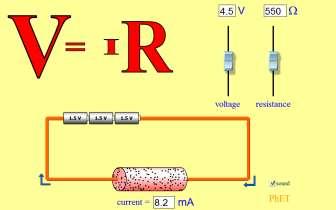
15 Practical 1 - Electricity 15
 V = voltage (volts) I =")
 Source: http://galitzin.mines.")
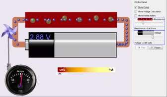
16 Current Flow & Ohm s Law Ohm s Law (1827) V = voltage (volts) I = Current (amperes) R = Resistance (ohms) Source: 16

17 Problems with Resistance Resistance: depends not only on the material from which the wire is made, but also the geometry of the wire. i.e. the length and thickness of the wire affects the reading. How can we apply this relatively simple experiment to determine electrical properties of earth materials? Source: 17

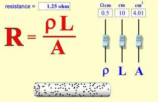
18 Use Resistivity, NOT Resistance Resistivity = resistance per unit volume Resistivity is a geometrically-independent quantity that is usually indicated by the Greek symbol ρ. Units are ohm-m (ohm-meters). 18
 are often used for small conductivity values. 1000mS/m = 1S/m. So 1mS/m = 1000 Ohm-m, since resistivity and conductivity are inversely related.")
19 Conductivity Conductivity = inverse of resistivity: 1/ρ Conductivity is often represented using sigma, σ Conductivity is given in units of Siemens per metre, or S/m. Units of millisiemens per metre (ms/m) are often used for small conductivity values. 1000mS/m = 1S/m. So 1mS/m = 1000 Ohm-m, since resistivity and conductivity are inversely related. Source; 19

20 Factors Affecting Resistivity - Porosity Source; 20
21 Factors Affecting Resistivity - Permeability Source: 21

22 Resistivity (Ω m) Factors Affecting Resistivity - Salinity 1,000, ,000 10,000 1, Source; 22
23 Factors Affecting Resistivity - Temperature Source; 23

 Source; http://www.eos.ubc.")
24 Factors Affecting Resistivity Clay Content Illite (a clay mineral) with total surface area of 100m 2 /gm (photo Credit: R. Knight.) Quartz overgrowths in sandstone with total surface area of 0.1m 2 /gm (photo credit: R. Knight.) Source; 24
25 Archie s Law (1942) ρ r ρ f = αϕ m Where, ρ r ρ f α ϕ m is the rock resistivity, in ohm-meters is the resistivity of the pore fluid is the coefficient of saturation 1 = complete saturation is the porosity is the cementation factor Archie, G.E., 1942, The electrical resistivity log as an aid in determining some reservoir characteristics: Trans. Am. Inst. Min., Metal. and Petr. Eng., v. 146, p
26 Formation Factor F = αϕ m Where, F α ϕ m is the formation factor is the coefficient of saturation 1 = complete saturation is the porosity is the cementation factor Archie, G.E., 1942, The electrical resistivity log as an aid in determining some reservoir characteristics: Trans. Am. Inst. Min., Metal. and Petr. Eng., v. 146, p
27 Archie s Law ρ r = Fρ f Where, ρ r F ρ f is the rock resistivity, in ohm-meters is the formation factor is the resistivity of the pore fluid Note: Archie s Law does not work when the rocks contain CLAY! Archie, G.E., 1942, The electrical resistivity log as an aid in determining some reservoir characteristics: Trans. Am. Inst. Min., Metal. and Petr. Eng., v. 146, p

28 Resistivity of Rock Forming Materials Source; 28

29 Resistivity of Rock Forming Materials 29
30 Current Density and Electric Field Source: 30

31 A First Estimate of Resistivity Source: 31

32 Current Flow - Two Closely Spaced Electrodes Current % of Total Path Current Source: 32

33 A Practical Way of Measuring Resistivity Source: 33
34 A Practical Way of Measuring Resistivity Source: 34
35 PART 3 Resistivity Surveys and Geology 1. Sources of Noise 2. Depth of Current Penetration Versus Current Electrode Spacing 3. Current Flow in Layered Media 4. Variation in Apparent Resistivity: Layered Versus Homogeneous Media 5. Current Flow in Layered Media Versus Electrode Spacing 35
36 Sources of Noise Electrode Polarization Use non-polarizing electrodes Reverse current flow in the current electrodes Telluric Currents Presence of Nearby Conductors Low Resistivity at the Near Surface Near-Electrode Geology and Topography Current Induction in Measurement Cables 36
37 Sources of Noise Source: 37

38 Depth of Current Penetration Versus Current Electrode Spacing Source: 38
39 Current Flow in Layered Media Source: 39

40 Variation in Apparent Resistivity: Layered Versus Homogeneous Media Source: 40

41 Current Flow in Layered Media Versus Electrode Spacing: Example 1 Source: 41
42 Current Flow in Layered Media Versus Electrode Spacing: Example 1 Source: 42

43 Current Flow in Layered Media Versus Electrode Spacing: Example 2 Source: 43
44 Current Flow in Layered Media Versus Electrode Spacing: Example 2 Source: 44
45 PART 4 Resistivity Equipment and Field Procedures 1. DC Resistivity Equipment 2. Survey Types Overview: Soundings and Profiles 3. Soundings: Wenner and Schlumberger 4. Electrode Spacings and Apparent Resistivity Plots 5. Advantages and Disadvantages of Wenner and Schlumberger Arrays 6. Resistivity Profiles 45

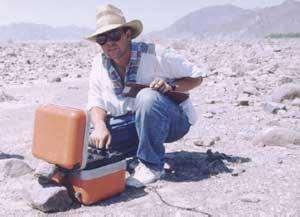
46 DC Resistivity Equipment 1. Current Source 2. Ammeter 3. Voltmeter 4. Electrodes 5. Cables Source: 46
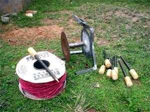
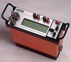
47 DC Resistivity Equipment ABEM Terrameter 47

48 DC Resistivity Equipment ABEM Terrameter LS 48


49 DC Resistivity Equipment IRIS SYSCAL Source: 49

50 Survey Types Overview: Soundings Source: 50
51 Vertical Electrical Sounding (VES) Source: 51
52 Vertical Electrical Sounding (VES) Source: 52

53 Vertical Electrical Sounding (VES) Source: 53
54 Vertical Electrical Sounding (VES) Source: 54

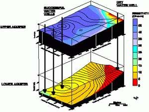
55 Applications of Soundings Source: 55

56 Survey Types Overview: Profiles Source: 56

57 Constant Separation Traversing (CST) Source: 57
58 Constant Separation Traversing (CST) Source: 58
59 Constant Separation Traversing (CST) Source: 59
60 Constant Separation Traversing (CST) Source: 60
61 Constant Separation Traversing (CST) Source: 61

62 Interpretation of CST Source: 62

63 Survey Types Overview: Profiles Geometrics OhmMapper Source: 63


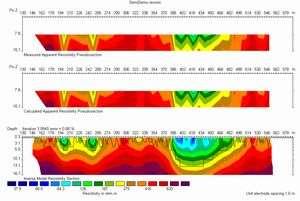
64 Survey Types Overview: Resistivity Imaging Source: 64

65 Resistivity Imaging Source: 65

66 Resistivity Imaging Source: 66

67 Resistivity Imaging Source: 67

68 Resistivity Imaging Source: 68
69 Resistivity Imaging Source: 69


70 Applications of Resistivity Imaging 1 Landfill Survey Salt Water Intrusion Survey Source: 70
71 Applications of Resistivity Imaging 2 Fracture Survey Source: 71

72 Survey Types Overview: Resistivity Monitoring Source: 72

73 Main Electrode Arrays: Schlumberger Array MN << AB Source: 73

74 Main Electrode Arrays: Wenner Array MN = AB/3 Source: 74
75 Main Electrode Arrays: Gradient Array MN is moved within the middle part of AB Source: IRIS INSTRUMENTS, Training course on Electrical methods,
76 Main Electrode Arrays: Rectangle Array MN is moved along various lines parallel to AB Source: IRIS INSTRUMENTS, Training course on Electrical methods,
77 Main Electrode Arrays: Dipole Dipole Array MN is moved a certain number of times away from AB, then AB is shifted of one spacing and so on. A pseudo section is obtained, a combination of profiling and shallow sounding Source: IRIS INSTRUMENTS, Training course on Electrical methods,

78 Electrode Spacings and Apparent Resistivity Plots Source: 78
79 Advantages and Disadvantages of Schlumberger Arrays Advantage Need to move the two current electrodes only for most readings. This can significantly decrease the time required to acquire a sounding. Because the potential electrodes remain in fixed locations, the effects of near-surface lateral variations in resistivity are reduced. Disadvantage Because the potential electrode spacing is small compared to the current electrode spacing, for large current electrode spacings, very sensitive voltmeters are required. In general, interpretations based on DC soundings will be limited to simple, horizontally layered structures. Source: 79
80 Advantages and Disadvantages of Wenner Arrays Advantage Potential electrode spacing increases as current electrode spacing increases. Less sensitive voltmeters are required. Source: Disadvantage All four electrodes, two current and two potential, must be moved to acquire each reading. Because all electrodes are moved for each reading, this method can be more susceptible to nearsurface, lateral variations in resistivity. These near-surface lateral variations could potentially be misinterpreted in terms of depth variations in resistivity. In general, interpretations based on DC soundings will be limited to simple, horizontally layered structures. 80
81 Choice of Array Key Questions: Which type of structure needs to be mapped? How sensitive is the resistivity meter? What is the background noise level? Considerations Depth of investigation Sensitivity of the array to vertical and horizontal structures Horizontal data coverage Signal strength 81
82 Resistivity Profiles Source: 82

83 Profile Example: Niger Village Water Supply Source: 83
84 PART 5 Interpretation of Resistivity Measurements 1. Apparent Resistivity Curves for Soundings Over One-Layered Media 2. Apparent Resistivity Curves in Two-Layered Media 3. Resistivity Modelling and Inversion 84

85 Apparent Resistivity Curves for Soundings Over One-Layered Media: Case 1 Source: 85
86 Apparent Resistivity Curves for Soundings Over One-Layered Media: Case 2 Source: 86

87 Apparent Resistivity Curves in Two-Layered Media: Case 1 Source: 87

88 Apparent Resistivity Curves in Two-Layered Media: Case 2 Source: 88
89 Apparent Resistivity Curves in Two-Layered Media Two-layer master set of sounding curves for the Schlumberger array. (Zohdy, 1974) Source: 89
90 A pparent R esistiv ity (ohm -m ) 1D Inversion 1X1D (Interpex Limited) 1000 U nregistered V ersion B alkh_ Spacing (m ) 90

91 1D Inversion GeoVES

92 2D Inversion 92
Geophysics Course Interpreting DC Resistivity Data
 NORAD supported project in MRRD covering Capacity Building and Institutional Cooperation in the field of Hydrogeology for Faryab Province Afghanistan Geophysics Course Interpreting DC Resistivity Data
Definition. Useful References
 Introduction to Geophysics Short Course Assignments http://www.mines.edu/fs_home/tboyd/gp311/modules/res/main.html Definition Resistivity Method - Observation of electric fields caused by current introduced
1. Resistivity of rocks
 RESISTIVITY 1) Resistivity of rocks 2) General principles of resistivity surveying 3) Field procedures, interpretation and examples 4) Summary and conclusions INDUCED POLARIZATION 1) General principles
Electrical Surveying (part A)
") Electrical Surveying (part A) Dr. Laurent Marescot Course given at the University of Fribourg (2009) Contact: laurent@tomoquest.com www.tomoquest.com 1 Introduction Electrical surveying Resistivity method
Electrical Surveying (part A) Dr. Laurent Marescot Course given at the University of Fribourg (2009) Contact: laurent@tomoquest.com www.tomoquest.com 1 Introduction Electrical surveying Resistivity method
Electrical prospecting involves detection of surface effects produced by electrical current flow in the ground.
 Electrical Surveys in Geophysics Electrical prospecting involves detection of surface effects produced by electrical current flow in the ground. Electrical resistivity method Induced polarization (IP)
CONTENTS 1. INTRODUCTION. 2. THE D.C. RESISTIVITY METHOD 2.1 Equipment 2.2 Survey Procedure 2.3 Data Reduction
 (i) CONTENTS 1. INTRODUCTION page 1 2. THE D.C. RESISTIVITY METHOD 2.1 Equipment 2.2 Survey Procedure 2.3 Data Reduction 3 3 3 3 3. GEOPHYSICAL RESULTS 3.1 General 3.2 Discussion 4 4 4 4. LIMITATIONS 5
Geoelectricity. ieso 2010
 Geoelectricity ieso 2010 1 RESISTIVITY SURVEY AT VENETO VILLA GRITTI AT THE TOWN OF TREVISO (VENETO REGION) The survey was carried out to verify the underground presence of the fondations of a rustic building.
Geology 228/378 Applied and Environmental Geophysics Lecture 6. DC resistivity Surveys
 Geology 228/378 Applied and Environmental Geophysics Lecture 6 DC resistivity Surveys Direct current (DC) Resistivity. Introduction 2. Current flow in the ground 3. Schlumberger, Wenner, dipole-dipole,
Electrical Methods. Resistivity Surveying
 Electrical Methods Resistivity Surveying Geologic Resistivity 1101 Resistivity surveying investigates variations of electrical resistance, by causing an electrical current to flow through the subsurface
GLE 594: An introduction to applied geophysics
 GLE 594: An introduction to applied geophysics Electrical Resistivity Methods Fall 2004 Earth Properties and Basic Theory Reading Today : 207-218 Next Lecture : 218-228 1 Introduction Link resistivity
Geophysics for Environmental and Geotechnical Applications
 Geophysics for Environmental and Geotechnical Applications Dr. Katherine Grote University of Wisconsin Eau Claire Why Use Geophysics? Improve the quality of site characterization (higher resolution and
ELECTRICAL PROSPECTING METHODS
 Suez Canal University Faculty of Science Department of Geology ELECTRICAL PROSPECTING METHODS Prepared By El-Arabi Hendi Shendi Professor of applied & environmental Geophysics 2008 1 CONTENTS Definitions
I) Resistivity. Literatur: Telford, Geldart und Sheriff (1990): Applied Geophysics, Second Edition, Cambridge University Press, NY.
 Resistivity. Literatur: Telford, Geldart und Sheriff (1990): Applied Geophysics, Second Edition, Cambridge University Press, NY.") I) Resistivity Literatur: Telford, Geldart und Sheriff (1990): Applied Geophysics, Second Edition, Cambridge University Press, NY. Bender, F. (Hg.) (1985): Angewandte Geowissenschaften, Bd. II, Enke Verlag,
I) Resistivity Literatur: Telford, Geldart und Sheriff (1990): Applied Geophysics, Second Edition, Cambridge University Press, NY. Bender, F. (Hg.) (1985): Angewandte Geowissenschaften, Bd. II, Enke Verlag,
Site Characterization & Hydrogeophysics
 Site Characterization & Hydrogeophysics (Source: Matthew Becker, California State University) Site Characterization Definition: quantitative description of the hydraulic, geologic, and chemical properties
MT Prospecting. Map Resistivity. Determine Formations. Determine Structure. Targeted Drilling
 MT Prospecting Map Resistivity Determine Formations Determine Structure Targeted Drilling Cross-sectional interpretation before and after an MT survey of a mineral exploration prospect containing volcanic
Introduction. Electrical surveying. Resistivity method Induced polarization method (IP) Self-potential (SP) method
 Self-potential (SP) method") Introduction Electrical surveying Resistivity method Induced polarization method (IP) Self-potential (SP) method Higher frequency methods (electromagnetic surveys): Electromagnetic induction methods Ground
Introduction Electrical surveying Resistivity method Induced polarization method (IP) Self-potential (SP) method Higher frequency methods (electromagnetic surveys): Electromagnetic induction methods Ground
Department of Geophysics Faculty of Earth Sciences King Abdulaziz University
 Department of Geophysics Faculty of Earth Sciences King Abdulaziz University Dr. Mansour A. Al-Garni Office: room 233/Buld. 27 OR Dept. chair office/buld. 55 Introduction to Geophysics EGP 211 Time: 10-10:55
ambiguity in earth sciences IESO Geophysics Section Eddy hartantyo, Lab Geofisika FMIPA UGM
 ambiguity in earth sciences IESO Geophysics Section Eddy hartantyo, Lab Geofisika FMIPA UGM Pelatihan Tahap II IESO Teknik Geologi UGM Februari 2009 1 Introduction Photos from http://www.eegs.org/whatis/
4.6 DC resistivity and IP field systems, data processing and interpretation
 4.6 DC resistivity and P field systems, data processing and interpretation Electrode arrays Response of a layered earth The anisotropic half space Response of simple inhomogeneities Solutions for arbitrary
Case Study: University of Connecticut (UConn) Landfill
 Landfill") Case Study: University of Connecticut (UConn) Landfill Problem Statement:» Locate disposal trenches» Identify geologic features and distinguish them from leachate and locate preferential pathways in fractured
Case Study: University of Connecticut (UConn) Landfill Problem Statement:» Locate disposal trenches» Identify geologic features and distinguish them from leachate and locate preferential pathways in fractured
MOUNT POLLEY MINING CORPORATION TECHNICAL REPORT ON MULTI-ELECTRODE RESISTIVITY AND SEISMIC REFRACTION SURVEYS MOUNT POLLEY TAILINGS DAM PROJECT
 MOUNT PLEY MINING CORPORATION TECHNICAL REPORT ON MULTI-ELECTRODE RESISTIVITY AND SEISMIC REFRACTION SURVEYS MOUNT PLEY TAILINGS DAM PROJECT LIKELY, B.C. by Claudia Krumbiegel, M.Sc. Cliff Candy, P.Geo.
Subsurface Characterization using Electrical Resistivity(Dipole-Dipole) method at Lagos State University (LASU) Foundation School, Badagry
 method at Lagos State University (LASU) Foundation School, Badagry") Available online at www.pelagiaresearchlibrary.com Advances in Applied Science Research, 2010, 1 (1): 174-181 Subsurface Characterization using Electrical Resistivity(Dipole-Dipole) method at Lagos State
Available online at www.pelagiaresearchlibrary.com Advances in Applied Science Research, 2010, 1 (1): 174-181 Subsurface Characterization using Electrical Resistivity(Dipole-Dipole) method at Lagos State
Surface and borehole electrical resistivity tomography
 Surface and borehole electrical resistivity tomography Laurent Marescot laurent@tomoquest.com Introduction Surface electrical resistivity surveying is based on the principle that the distribution of electrical
OWNER OPERATOR: BLACKWATER EXPLORATIONS LTD. REPORT ON RESISTIVITY PROFILING SURVEY PLACER GOLD EXPLORATION
 OWNER OPERATOR: BLACKWATER EXPLORATIONS LTD. REPORT ON RESISTIVITY PROFILING SURVEY PLACER GOLD EXPLORATION CARIBOO MINING DISTRICT NTS 93G CLAIM PC682023 Latitude 53 13 35.64 Longitude 122 49 40.65 by
Geophysics of Exploration for Water. Geoelectric methods III. edited by Peter Vass
 Geophysics of Exploration for Water Geoelectric methods III edited by Peter Vass The phenomenon of induced polarization was already noticed at the early stage of applying direct current electrical methods
2-D Resistivity Study: The Horizontal Resolution Improvement by Introducing the Enhancing Horizontal Resolution (EHR) Technique
 Technique") Open Journal of Geology, 213, 3, 1-6 doi:1.4236/ojg.213.32b1 Published Online April 213 (http://www.scirp.org/journal/ojg) 2-D Resistivity Study: The Horizontal Resolution Improvement by Introducing the
Open Journal of Geology, 213, 3, 1-6 doi:1.4236/ojg.213.32b1 Published Online April 213 (http://www.scirp.org/journal/ojg) 2-D Resistivity Study: The Horizontal Resolution Improvement by Introducing the
Groundwater Sustainability at Wadi Al Bih Dam, Ras El Khaimah, United Arab Emirates (UAE) using Geophysical methods
 using Geophysical methods") Groundwater Sustainability at Wadi Al Bih Dam, Ras El Khaimah, United Arab Emirates (UAE) using Geophysical methods Ahmed Murad, Amir Gabr, Saber Mahmoud, Hasan Arman & Abdulla Al Dhuhoori Geology Department
Groundwater Sustainability at Wadi Al Bih Dam, Ras El Khaimah, United Arab Emirates (UAE) using Geophysical methods Ahmed Murad, Amir Gabr, Saber Mahmoud, Hasan Arman & Abdulla Al Dhuhoori Geology Department
PE OIL AND GAS EXPLORATION METHODS COURSE STRUCTURE. I. FUNDAMENTAL CONSIDERATIONS (5 Hrs.) III. SEISMIC REFLECTION METHOD
 III. SEISMIC REFLECTION METHOD") PE6050 - OIL AND GAS EXPLORATION METHODS Total Hours: 50 Faculty: Dr. Rajesh R Nair COURSE STRUCTURE I. FUNDAMENTAL CONSIDERATIONS (5 Hrs.) - Stress - Strain Relationship - Elastic Coefficients - Seismic
PE6050 - OIL AND GAS EXPLORATION METHODS Total Hours: 50 Faculty: Dr. Rajesh R Nair COURSE STRUCTURE I. FUNDAMENTAL CONSIDERATIONS (5 Hrs.) - Stress - Strain Relationship - Elastic Coefficients - Seismic
Lesson 1 Introduction to geophysical methods Emanuele Forte
 Lesson 1 Introduction to geophysical methods Emanuele Forte 3 rd September 2016 Naxos, Greece 1 Outline - What is Geophysics - Base concepts: (Geo)Physical parameters Sensitivity Resolution - Active and
INTERGRATED GEOPHYSICAL METHODS USED TO SITE HIGH PRODUCER GEOTHERMAL WELLS
 Presented at Short Course VII on Exploration for Geothermal Resources, organized by UNU-GTP, GDC and KenGen, at Lake Bogoria and Lake Naivasha, Kenya, Oct. 27 Nov. 18, 2012. GEOTHERMAL TRAINING PROGRAMME
A Brief Introduction to Magnetotellurics and Controlled Source Electromagnetic Methods
 A Brief Introduction to Magnetotellurics and Controlled Source Electromagnetic Methods Frank Morrison U.C. Berkeley With the help of: David Alumbaugh Erika Gasperikova Mike Hoversten Andrea Zirilli A few
LIST OF FIGURES APPENDICES
 RESISTIVITY / INDUCED POLARIZATION SURVEY EL PORVENIR PROJECT MUNICIPALITY OF REMEDIOS, ANTIOQUIA, COLOMBIA LOGISTICS REPORT M-17427 APRIL 2017 TABLE OF CONTENTS Abstract... 1 1. The Mandate... 2 2. El
Geophysical Investigation: A Case Study of Basement Complex, Nigeria
 Geophysical Investigation: A Case Study of Basement Complex, Nigeria Adiela U.P 1, Ayodele Moses Oyewole 2 and Omoirabor Omoleomo 3 1 Department of Petroleum Engineering, Nigerian Agip Oil Company, Port
INTRODUCTION TO APPLIED GEOPHYSICS
 INTRODUCTION TO APPLIED GEOPHYSICS EXPLORING THE SHALL0W SUBSURFACE H. Robert Burger Anne F. Sheehan Craig H.Jones VERSITY OF COLORADO VERSITY OF COLORADO W. W. NORTON & COMPANY NEW YORK LONDON Contents
ธรณ ฟ ส กส อ.ดร. ส ว มล อ ดพ วย
 205482 Geophysics ธรณ ฟ ส กส อ.ดร. ส ว มล อ ดพ วย E-mail: suwimons@hotmail.com Office: GB111-4 ภาคว ชาธรณ ว ทยา คณะว ทยาศาสตร มหาว ทยาล ยเช ยงใหม มหาวทยาลยเชยงใหม GEOPHYSICS Physics of the earth = applies
ENVIRONMENTAL AND ENGINEERING GEOPHYSICS
 ENVIRONMENTAL AND ENGINEERING GEOPHYSICS Environmental Engineering MSc 08/09 nd semester COURSE COMMUNICATION DOCUMENT University of Miskolc Faculty of Earth Science and Engineering Institute of Geophysics
GY 402: Sedimentary Petrology
 UNIVERSITY OF SOUTH ALABAMA GY 402: Sedimentary Petrology Lecture 27: Introduction to Wireline Log Interpretations Instructor: Dr. Douglas W. Haywick Last Time Carbonate Diagenesis Diagenesis 0.5 mm PPL
CHARACTERIZATION OF SOIL PROFILE OF DHAKA CITY USING ELECTRICAL RESISTIVITY TOMOGRAPHY (ERT)
") CHARACTERIZATION OF SOIL PROFILE OF DHAKA CITY USING ELECTRICAL RESISTIVITY TOMOGRAPHY (ERT) Mehedi Ahmed ANSARY 1, B.S. Pushpendue BISWAS 2 and Abul KHAIR 3 1 Professor, Department of Civil Engineering
CHARACTERIZATION OF SOIL PROFILE OF DHAKA CITY USING ELECTRICAL RESISTIVITY TOMOGRAPHY (ERT) Mehedi Ahmed ANSARY 1, B.S. Pushpendue BISWAS 2 and Abul KHAIR 3 1 Professor, Department of Civil Engineering
ELECTRICAL RESISTIVITY TOMOGRAPHY
 NOTIO Association Clay Technological Centre C/ Río Cabriel s/n 45007 Toledo Tel.: 925 24 11 62 info@notio.es www.notio.es Page 1 / 7 SUMMARY 1. PHYSICAL FUNDAMENTALS OF THE... 3 1.1. ELECTRICAL BEHAVIOR
Vertical Electrical Sounding (Ves) For The Determination Of Under Ground Resistivity In Part Of Nigeria Wilberforce Island,Amassoma, Bayelsa State
 For The Determination Of Under Ground Resistivity In Part Of Nigeria Wilberforce Island,Amassoma, Bayelsa State") IOSR Journal of Research & Method in Education (IOSR-JRME) e-issn: 2320 7388,p-ISSN: 2320 737X Volume 7, Issue 2 Ver. III (Mar. - Apr. 2017), PP 53-61 www.iosrjournals.org Vertical Electrical Sounding
IOSR Journal of Research & Method in Education (IOSR-JRME) e-issn: 2320 7388,p-ISSN: 2320 737X Volume 7, Issue 2 Ver. III (Mar. - Apr. 2017), PP 53-61 www.iosrjournals.org Vertical Electrical Sounding
4 Hydro-geophysical methods. 3.2 Technical meetings. 3.3 Additional investigations
 the geological context: outcrops, tilts, directions of identified fractures, profiles observed in wells etc.; the geomorphological context: relief, hydrographic network, potential infiltration zones, floodable
Module for: Resistivity Theory (adapted/modified from lectures in PETE 321 (Jensen/Ayers))
)") (PETE 663 Formation Evaluation and the Analysis of Reservoir Performance (Fall 2003)) Module for: Resistivity Theory (adapted/modified from lectures in PETE 321 (Jensen/Ayers)) J. L. Jensen W.B. Ayers
(PETE 663 Formation Evaluation and the Analysis of Reservoir Performance (Fall 2003)) Module for: Resistivity Theory (adapted/modified from lectures in PETE 321 (Jensen/Ayers)) J. L. Jensen W.B. Ayers
Geophysical Study of Limestone Attributes At Abudu Area of Edo State, Nigeria
 Journal of Emerging Trends in Engineering and Applied Sciences (JETEAS) 2 (5): 795-800 Scholarlink Research Institute Journals, 2011 (ISSN: 2141-7016) jeteas.scholarlinkresearch.org Journal of Emerging
Verification and Validation Calculations Using the STAR Geophysical Postprocessor Suite
 SAIC-03/1040 Final Report Verification and Validation Calculations Using the STAR Geophysical Postprocessor Suite Prepared by: J. W. Pritchett December 2003 Verification and Validation Calculations Using
Improved Exploration, Appraisal and Production Monitoring with Multi-Transient EM Solutions
 Improved Exploration, Appraisal and Production Monitoring with Multi-Transient EM Solutions Folke Engelmark* PGS Multi-Transient EM, Asia-Pacific, Singapore folke.engelmark@pgs.com Summary Successful as
CHAPTER 5 GEOPHYSICAL SURVEY. 5.1 Purpose of Survey
 CHAPTE 5 GEOPHYSICAL SUVEY 5.1 Purpose of Survey The objective of the Time Domain Electro- Magnetic (TDEM) survey was to define the electrical structure of the Stampriet Artesian Basin and relate this
Hydrological geophysical relationships
 International PhD Course in HYDROGEOPHYSICS Hydrological geophysical relationships Andrew Binley Lancaster University Overview In the course we will concentrate on electrical, electromagnetic and radar
RESISTIVITY IMAGING IN EASTERN NEVADA USING THE AUDIOMAGNETOTELLURIC METHOD FOR HYDROGEOLOGIC FRAMEWORK STUDIES. Abstract.
 RESISTIVITY IMAGING IN EASTERN NEVADA USING THE AUDIOMAGNETOTELLURIC METHOD FOR HYDROGEOLOGIC FRAMEWORK STUDIES Darcy K. McPhee, U.S. Geological Survey, Menlo Park, CA Louise Pellerin, Green Engineering,
International Journal of Basic and Applied Sciences Raibu et. al., Vol. 1 No. 2 ISSN: (A peer reviewed International Journal)
") (A peer reviewed International Journal) Determination of Aquifer Layer by the Application of Electrical Resistivity and Electromagnetic Method of Exploration at Ojoo Town Oyo State Southwestern Nigeria
(A peer reviewed International Journal) Determination of Aquifer Layer by the Application of Electrical Resistivity and Electromagnetic Method of Exploration at Ojoo Town Oyo State Southwestern Nigeria
An Introduction to Geophysical Exploration
 An Introduction to Geophysical Exploration Philip Kearey Department of Earth Sciences University of Bristol Michael Brooks Ty Newydd, City Near Cowbridge Vale of Glamorgan Ian Hill Department of Geology
Adebayo O. Ojo, M.Sc. 1* and Martins O. Olorunfemi, Ph.D *
 A Graphical and Semi-Quantitative Technique for Investigating Vertical Electrical Sounding (VES) Curves for Indices of Confined Fractured Basement Column. Adebayo O. Ojo, M.Sc. 1* and Martins O. Olorunfemi,
Verification of Archie Constants Using Special Core Analysis and Resistivity Porosity Cross Plot Using Picket Plot Method
 Int'l Journal of Computing, Communications & Instrumentation Engg. (IJCCIE) Vol. 4, Issue (207) ISSN 2349-469 EISSN 2349-477 Verification of Archie Constants Using Special Core Analysis and Resistivity
Magnetotelluric (MT) Method
 Method") Magnetotelluric (MT) Method Dr. Hendra Grandis Graduate Program in Applied Geophysics Faculty of Mining and Petroleum Engineering ITB Geophysical Methods Techniques applying physical laws (or theory) to
Magnetotelluric (MT) Method Dr. Hendra Grandis Graduate Program in Applied Geophysics Faculty of Mining and Petroleum Engineering ITB Geophysical Methods Techniques applying physical laws (or theory) to
APPENDIX A: Magnetotelluric Data in Relation to San Pedro Mesa Structural. The San Pedro Mesa structural high (discussed in main text of paper) was
 was") Page of DR for GSA Special Paper 9, Chapter, Geophysical constraints APPENDIX A: Magnetotelluric Data in Relation to San Pedro Mesa Structural High The San Pedro Mesa structural high (discussed in main
Page of DR for GSA Special Paper 9, Chapter, Geophysical constraints APPENDIX A: Magnetotelluric Data in Relation to San Pedro Mesa Structural High The San Pedro Mesa structural high (discussed in main
Geoelectrical characterization for liquefaction at coastal zone in South Aceh
 Geoelectrical characterization for liquefaction at coastal zone in South Aceh Muhammad Syukri Laboratory of Geophysics, Department of Physics, Faculty of Mathematic and Sciences, Syiah Kuala University.
Resistivity & IP methods
 International PhD Course in HYDROGEOPHYSICS Resistivity & IP methods Andrew Binley Lancaster University Overview We have demonstrated links between hydrological and geophysical properties and show the
Well Logging. Salam Al Rbeawi 2011
 Well Logging Salam Al Rbeawi 2011 Well Logging: Is a technique used for formation evaluation to determine the size of the reservoir and the amount of oil and gas in place. The following parameters can
Vertical electrical sounding (VES) for subsurface geophysical investigation in Kanigiri area, Prakasam district, Andhra Pradesh, India
 for subsurface geophysical investigation in Kanigiri area, Prakasam district, Andhra Pradesh, India") Available online at www.pelagiaresearchlibrary.com Advances in Applied Science Research, 2014, 5(5):82-86 ISSN: 0976-8610 CODEN (USA): AASRFC Vertical electrical sounding (VES) for subsurface geophysical
Available online at www.pelagiaresearchlibrary.com Advances in Applied Science Research, 2014, 5(5):82-86 ISSN: 0976-8610 CODEN (USA): AASRFC Vertical electrical sounding (VES) for subsurface geophysical
Geophysical Investigation of the Old Gaborone Dumpsite, Botswana SHEMANG, E M; MOLWALEFHE, L; CHAOKA, TR; MOSWEU E; NONDO, M
 JASEM ISSN 1119-8362 All rights reserved Full-text Available Online at www.bioline.org.br/ja J. Appl. Sci. Environ. Mgt. September, 2006 Vol. 10 (3) 87-92 Geophysical Investigation of the Old Gaborone
Overview of geophysical methods used in geophysical exploration
 Overview of geophysical methods used in geophysical exploration Lúdvík S. Georgsson United Nations University Geothermal Training Programme Orkustofnun Reykjavík ICELAND The role of the geophysicist Measuring
Hamed Aber 1 : Islamic Azad University, Science and Research branch, Tehran, Iran. Mir Sattar Meshin chi asl 2 :
 Present a Proper Pattern for Choose Best Electrode Array Based on Geological Structure Investigating in Geoelectrical Tomography, in order to Get the Highest Resolution Image of the Subsurface Hamed Aber
Geophysical Surveys for Groundwater Modelling of Coastal Golf Courses
 1 Geophysical Surveys for Groundwater Modelling of Coastal Golf Courses C. RICHARD BATES and RUTH ROBINSON Sedimentary Systems Research Group, University of St. Andrews, St. Andrews, Scotland Abstract
3. Magnetic Methods / 62
 Contents Preface to the Second Edition / xv Excerpts from Preface to the FirstEdition / xvii Mathematical Conventions / xix 1. Introduction / 1 Reference / 5 2. Gravity Methods / 6 2. I. Introduction /
PHYSICS FORM 5 ELECTRICAL QUANTITES
 QUANTITY SYMBOL UNIT SYMBOL Current I Amperes A Voltage (P.D.) V Volts V Resistance R Ohm Ω Charge (electric) Q Coulomb C Power P Watt W Energy E Joule J Time T seconds s Quantity of a Charge, Q Q = It
Geophysical mapping and imaging of soil structures: basic overview
 Geophysical mapping and imaging of soil structures: basic overview Stéphane Garambois Landslide team, LGIT, Université Joseph Fourier 3D imaging of the water table (seismic) Geophysical methods 1 Plan
Applied Geophysics for Environmental Site Characterization and Remediation
 Applied Geophysics for Environmental Site Characterization and Remediation MSECA Webinar September 24, 2015 John Mundell, P.E., L.P.G. Ryan Brumbaugh, L.P.G. MUNDELL & ASSOCIATES, INC. Webinar Objective
PROCEEDING, SEMINAR NASIONAL KEBUMIAN KE-8 Academia-Industry Linkage OKTOBER 2015; GRHA SABHA PRAMANA
 INCORPORATION OF ELECTRICAL RESISTIVITY TOMOGRAPHY (ERT) DATA IN GEOLOGICAL MODELLING AS METHOD TO INCREASE MODEL ACCURACY IN UNSERPENTINISED ULTRAMAFIC HOSTED NICKEL LATERITE DEPOSIT Budhi Kumarawarman
APPLICATION OF ELECTRICAL RESISTIVITY TOMOGRAPHY FOR SAND UNDERWATER EXTRACTION
 International Scientific Conference GEOBALCANICA 2018 APPLICATION OF ELECTRICAL RESISTIVITY TOMOGRAPHY FOR SAND UNDERWATER EXTRACTION Maya Grigorova Ivaylo Koprev University of Mining and Geology St. Ivan
Analysis of electrical resistivity data for the determination of aquifer depth at Sapele RD in Benin city
 Available online at www.pelagiaresearchlibrary.com Advances in Applied Science Research, 203, 4(6):268-276 ISSN: 0976-860 CODEN (USA): AASRFC Analysis of electrical resistivity data for the determination
The Use of Vertical Electrical Sounding (VES) for Subsurface Geophysical Investigation around Bomo Area, Kaduna State, Nigeria
 for Subsurface Geophysical Investigation around Bomo Area, Kaduna State, Nigeria") IOSR Journal of Engineering (IOSRJEN) e-issn: 2250-3021, p-issn: 2278-8719 Vol. 3, Issue 1 (Jan. 2013), V4 PP 10-15 The Use of Vertical Electrical Sounding (VES) for Subsurface Geophysical Investigation
IOSR Journal of Engineering (IOSRJEN) e-issn: 2250-3021, p-issn: 2278-8719 Vol. 3, Issue 1 (Jan. 2013), V4 PP 10-15 The Use of Vertical Electrical Sounding (VES) for Subsurface Geophysical Investigation
Lesson 2 Geophysical methods for rock mass characterization Emanuele Forte
 Lesson 2 Geophysical methods for rock mass characterization Emanuele Forte 3 rd September 2016 Naxos, Greece Outline Review of geophysical methods and their applicability to rock mass characterization:
Principles of Applied Geophysics
 Principles of Applied Geophysics Fifth edition D.S. Parasnis Professor emeritus of Applied Geophysics Department of Applied Geophysics, University ofluled, Lulea, Sweden Fellow of the Royal Swedish Academy
B7 Applications of DC resistivity exploration
 B7 Applications of DC resistivity exploration Modern DC resistivity surveys collect data for generating a 2-D or 3-D geoelectric model of the Earth. A simple 1-D analysis does not often yield results that
Geophysics and Mapping. presented by: Stephen Brown
 Geophysics and Mapping presented by: Stephen Brown Recommended book for INIGEMM Geophysics for the mineral exploration geoscientist, by Michael Dentith and Stephen Mudge, Cambridge University Press, 2014.
Geophysical Investigation of Ground Water Using Vertical Electrical Sounding and Seismic Refraction Methods
 International Journal of Petroleum and Petrochemical Engineering (IJPPE) Volume 2, Issue 1, 2016, PP 6-11 ISSN 2454-7980 (Online) www.arcjournals.org Geophysical Investigation of Ground Water Using Vertical
Environmental and Exploration Geophysics I. Resistivity II tom.h.wilson
 Environmental and Exploration Geophysics I Resistivity II tom.h.wilson tom.wilson@mail.wvu.edu Department of Geology and Geography West irginia University Morgantown, W For next class complete in-class
Application Of Resistivity Method Wenner Configuration For Determining Aquifer Position At Pasir Impun Area, Bandung, West Java
 October 21, 215 Application Of Resistivity Method Wenner Configuration For Determining Aquifer Position At Pasir Impun Area, Bandung, West Java Diyan Parwatiningtyas a*, Dasmo b, and Achmad Sjamsuri c
2-D RESISTIVITY IMAGING SURVEY FOR WATER-SUPPLY TUBE WELLS IN A BASEMENT COMPLEX: A CASE STUDY OF OOU CAMPUS, AGO-IWOYE SW NIGERIA
 2-D RESISTIVITY IMAGING SURVEY FOR WATER-SUPPLY TUBE WELLS IN A BASEMENT COMPLEX: A CASE STUDY OF OOU CAMPUS, AGO-IWOYE SW NIGERIA 1 AYOLABI, Elijah Adebowale. 2 FOLORUNSO, Adetayo Femi. and 3 ARIYO, Stephen
Integrated Geophysical Model for Suswa Geothermal Prospect using Resistivity, Seismics and Gravity Survey Data in Kenya
 Proceedings World Geothermal Congress 2015 Melbourne, Australia, 19-25 April 2015 Integrated Geophysical Model for Suswa Geothermal Prospect using Resistivity, Seismics and Gravity Survey Data in Kenya
Study on the Four- property Relationship of Reservoirs in YK Area of Ganguyi Oilfield
 Study on the Four- property elationship of eservoirs in YK Area of Ganguyi Oilfield Abstract Xinhu Li, Yingrun Shang Xi an University of Science and Technology, Xi an 710054, China. shangyingrun@163.com
Geophysics for Geothermal Exploration
 Geophysics for Geothermal Exploration Dr. Hendra Grandis Geofisika - ITB Agenda Basic concept of Geophysics: : Review Geophysical signatures of a geothermal system Geophysical methods for geotermal exploration
Electronic Geophysical Surveys LirJted, 250 South Fell Avenue, North Burnahy 2, B. C. Telenhone:
 L GEOWG GEOPIIYSICAL SEPORT #IlO of the Gaichon Contact Group of Claims!. 1 mile NNbJ of Max&$ Lake, B.C. 50 North - 120 Vest for 4": "~ II' George Saarse Aup,,. 12 - Aug. 29, 1964 D. L. Hings, P. Eng.
TOUGH2 Flow Simulator Used to Simulate an Electric Field of a Reservoir With a Conductive Tracer for Fracture Characterization
 GRC Transactions, Vol. 36, 2012 TOUGH2 Flow Simulator Used to Simulate an Electric Field of a Reservoir With a Conductive Tracer for Fracture Characterization Lilja Magnusdottir and Roland N. Horne Stanford
Well Logging Importance in Oil and Gas Exploration and Production
 Well Logging Importance in Oil and Gas Exploration and Production Dr. R. Giri Prasad 1 1 Associate Professor, Dept. of Petroleum Engineering, Aditya Engineering College, hod_pt@aec.edu.in I. INTRODUCTION
LECTURE 10. Module 3 : Field Tests in Rock 3.6 GEOPHYSICAL INVESTIGATION
 LECTURE 10 3.6 GEOPHYSICAL INVESTIGATION In geophysical methods of site investigation, the application of the principles of physics are used to the study of the ground. The soil/rock have different characteristics
Electrical Resistivity Survey for Delineating Seawater Intrusion in a Coastal Aquifer
 Electrical Resistivity Survey for Delineating Seawater Intrusion in a Coastal Aquifer Sung-Ho Song*, Gyu-Sang Lee*, Jin-Sung Kim*, Baekuk Seong*, Young-gyu Kim*, Myung-Ha Woo* and Namsik Park** Abstract
An Introduction to Applied and Environmental Geophysics
 An to Applied and Environmental Geophysics 2nd Edition John M. Reynolds Reynolds International Ltd Preface to the 2 na Edition Acknowledgements 1 1.1 1.2 1.3 1.4 1.5 What are 'applied' and 'environmental'
Geology 228/378 Applied & Environmental Geophysics Lecture 8. Induced Polarization (IP) and Nuclear Magnetic Resonance (NMR)
 and Nuclear Magnetic Resonance (NMR)") Geology 228/378 Applied & Environmental Geophysics Lecture 8 Induced Polarization (IP) and Nuclear Magnetic Resonance (NMR) Induced Polarization (IP) and Nuclear Magnetic Resonance (NMR) 1. Time domain
Geology 228/378 Applied & Environmental Geophysics Lecture 8 Induced Polarization (IP) and Nuclear Magnetic Resonance (NMR) Induced Polarization (IP) and Nuclear Magnetic Resonance (NMR) 1. Time domain
Summary. Introduction
 Effect of over- and under-burden on time-lapse CSEM monitoring capabilities Arash JafarGandomi* and Andrew Curtis, School of GeoSciences, The University of Edinburgh, Kings Buildings, Edinburgh EH9 3JW,
POTASH DRAGON CHILE GEOPHYSICAL SURVEY TRANSIENT ELECTROMAGNETIC (TEM) METHOD. LLAMARA and SOLIDA PROJECTS SALAR DE LLAMARA, IQUIQUE, REGION I, CHILE
 METHOD. LLAMARA and SOLIDA PROJECTS SALAR DE LLAMARA, IQUIQUE, REGION I, CHILE") POTASH DRAGON CHILE GEOPHYSICAL SURVEY TRANSIENT ELECTROMAGNETIC (TEM) METHOD LLAMARA and SOLIDA PROJECTS SALAR DE LLAMARA, IQUIQUE, REGION I, CHILE OCTOBER 2012 CONTENT Page I INTRODUCTION 1 II FIELD
POTASH DRAGON CHILE GEOPHYSICAL SURVEY TRANSIENT ELECTROMAGNETIC (TEM) METHOD LLAMARA and SOLIDA PROJECTS SALAR DE LLAMARA, IQUIQUE, REGION I, CHILE OCTOBER 2012 CONTENT Page I INTRODUCTION 1 II FIELD
Vertical Electrical Sounding Survey for Groundwater Exploration in Parts of Anyigba and its Environs, in the Anambra Basin of Nigeria
 British Journal of Applied Science & Technology 4(): 978-988, 204 SCIENCEDOMAIN international www.sciencedomain.org Vertical Electrical Sounding Survey for Groundwater Exploration in Parts of and its Environs,
LITTLE ABOUT BASIC PETROPHYSICS
 LITTLE ABOUT BASIC PETROPHYSICS Author: MUHAMMAD ZAHID M.Sc (Applied Geology) Specialization in Petrophysics University of Azad Jammu & Kashmir, Muzaffarabad. ENTER Introduction - Determination of Physical
Seismoelectric Ground-flow DC-4500 Locator
 Seismoelectric Ground-flow DC-4500 Locator Introduction The seismoelectric survey is a new technology combined the electro kinetic potential method and geophysical technology. It is applied directly to
water L v i Chapter 4 Saturation
 4. Resistivity The presence of hydrocarbons is identified by the electrical resistance of the formation. These electrical properties of rocks depend on the pore geometry and fluid distribution. That is,
Introducing the Stratagem EH4. Electrical Conductivity Imaging System Hybrid-Source Magnetotellurics
 Introducing the Stratagem EH4 Electrical Conductivity Imaging System Hybrid-Source Magnetotellurics Stratagem EH4 Hybrid-Source Magnetotellurics Frequency range of 10 Hz to 90k Hz Approx. depth of investigation
Received 12 February 2010 Accepted 25 March Abstract. Keywords: sounding resistivity, gem-bearing gravel layer, Wenner, Schlumberger
 One Dimensional Resistivity Sounding for Resolving Gem-bearing Gravel Layer: A Comparison of Schlumberger with Wenner Techniques at Bo Rai, Eastern Thailand Piyaphong Chenrai 1, Punya Charusiri 1* and
Relevance of 2D Electrical Imaging in Subsurface Mapping: Case Study of National Animal Production Research Institute (NAPRI), Zaria.
, Zaria.") Relevance of 2D Electrical Imaging in Subsurface Mapping: Case Study of National Animal Production Research Institute (NAPRI), Zaria. S.I. Fadele, Ph.D. (in view) 1* ; J. Adamu, M.Sc. 2 ; N.O. Patrick,
Relevance of 2D Electrical Imaging in Subsurface Mapping: Case Study of National Animal Production Research Institute (NAPRI), Zaria. S.I. Fadele, Ph.D. (in view) 1* ; J. Adamu, M.Sc. 2 ; N.O. Patrick,
SUBMITTAL FEASIBILITY STUDY GEOPHYSICAL INVESTIGATION SAN JUAN BASIN SAN JUAN CAPISTRANO, CALIFORNIA. GEOVision Project No
 SUBMITTAL FEASIBILITY STUDY GEOPHYSICAL INVESTIGATION SAN JUAN BASIN SAN JUAN CAPISTRANO, CALIFORNIA GEOVision Project No. 15027 Prepared for Santa Margarita Water District 26111 Antonio Parkway Rancho
The Efficacy of Enhancing Horizontal Resolution (EHR) Technique in Shallow Subsurface Study Using 2D Resistivity Method at Bukit Bunuh
 Technique in Shallow Subsurface Study Using 2D Resistivity Method at Bukit Bunuh") 212 International Conference on Geological and Environmental Sciences IPCBEE vol.3 6(212) (212)IACSIT Press, Singapoore The Efficacy of Enhancing Horizontal Resolution (EHR) Technique in Shallow Subsurface
212 International Conference on Geological and Environmental Sciences IPCBEE vol.3 6(212) (212)IACSIT Press, Singapoore The Efficacy of Enhancing Horizontal Resolution (EHR) Technique in Shallow Subsurface
Afolabi O.M. Physics and Electronics Department, Adekunle Ajasin University, Akungba Akoko
 Electrical Conductivity Instrument Construction and Application for Detecting Subsurface Wood and Metal Afolabi O.M. Physics and Electronics Department, Adekunle Ajasin University, Akungba Akoko Abstract: