Applied Geophysics for Environmental Site Characterization and Remediation
|
|
|
- Bertha Logan
- 6 years ago
- Views:
Transcription


1 Applied Geophysics for Environmental Site Characterization and Remediation MSECA Webinar September 24, 2015 John Mundell, P.E., L.P.G. Ryan Brumbaugh, L.P.G. MUNDELL & ASSOCIATES, INC.
2 Webinar Objective Introduce the use of geophysical survey methods to enhance standard environmental site characterization practices and improve the design of remedial alternatives for complex site and geologic conditions.

3 Overview Who are we? What environmental consultants do? Geophysical Survey Methods Practical Applications Conclusion/Questions


4 Who Are We? Consulting professionals with geologic, geochemical, geophysical, and engineering backgrounds Focused on the use of geophysics integrated into environmental, engineering, water resources, and construction projects Personnel have performed geophysical surveys since Ryan Brumbaugh John Mundell
5 What environmental consultants do? Geophysics - Environmental Environmental Site Assessments Phase I ESAs Phase II ESAs Reconstruction of Site Development History UST Search/Old Tank Pits/Fill Materials Piping Systems and Utilities Disposal Areas (Drums, Waste, Debris) Conceptual Site Model Development and Refinement with Complex Geology

6 Conceptual Site Model
7 What environmental consultants do? Geophysics - Environmental Industrial Contamination Projects Source Areas, Contamination Type/Severity/Extent Migration Pathway Analysis Product/Vent/Utility Lines Aquifer (Sand/Gravel/Bedrock) Distribution Preferential Pathways Fractures, Faults, Karst Features
8 What environmental consultants do? Geophysics - Environmental Groundwater Investigations/Remediation Aquifer/Sand/Gravel Unit Mapping Fracture/fault/karst delineation Placement of Wells (Monitoring/Production) Enhanced Design of In-situ Treatment Monitoring of Remediation Progress
9 Groundwater Remediation 101 To be effective, you must know Where the source of the plume impacts are Where the chemical impacts have gone How significant are the impacts If these remain unknown, it is highly likely you will fail to be able to successfully cleanup a contaminant plume!

10 Glacial Terrain Bedrock Terrain Karst Terrain
11 Geologic Complexity Can cause plume movement in directions not expected by subsurface conditions only described by a classic widely-spaced soil boring and monitoring well-based subsurface exploration program Subsurface data density limits the development of an accurate Conceptual Site Model that can adequately describe groundwater movement and plume progression.

12 Midwestern Geologic Complexity
13 Technologies used to quantify properties of soils, bedrock and groundwater in an understandable manner. Technologies providing subsurface information without direct samling. Technologies that can reduce time to collect information, drilling and cost.
14 A way of measuring the Earth s natural or induced properties for the purpose of characterizing its variability. Contrasts in surface or subsurface materials cause changes to these properties, and allow us to locate their position and depth.
15 The Commonly Applied Technologies Potential Field Methods - gravity & magnetics Transmitted Energy Source Methods - seismic & ground penetrating radar Electromagnetic Methods - conductivity, TEM, VLF Electrical Methods - resistivity & IP
16 Geophysical Methods Electromagnetic Metal Detection Electromagnetic Conductivity Electrical Resistivity Imaging Seismic (Refraction, Surface Wave) Microgravity Ground Penetrating Radar (GPR) Downhole Logging


17 EM61 Electromagnetic Metal Detection System This electromagnetic instrument is specifically designed to detect conductive metallic objects buried within the upper 10 feet of the subsurface

18 EM61 is Useful for Locating Product Storage (tanks, drums), Product Piping, Waste Materials, and All Metallic Utilities


19 EM34: Deepest Conductivity Meter Electromagnetic Conductivity Meters EM31: Moderate Depth Conductivity Meter EM38: High Res, Shallow Conductivity Meter GEM2: Multi-frequency Conductivity Meter

20 EM34 Maps Can be Used to Delineate Plumes, Define Geology, and Find Preferential Pathways

21 EM31 Used to Delineate Fill/Waste Areas and Give Insight into Historical Site Development

22 EM38 Used to Located Shallow Preferential Pathways and Impacted Soils

23 GEM2 Terrain Conductivity Map Looking for Areas Prone to Subsidence..


24 2D Electrical Resistivity Imaging System High Detail Method for Characterizing Subtle Variations in Both Shallow and Deeper Subsurface Resistivity Often used in conjunction with surface mapping techniques such as EM31 or GEM2 Works in both rural and urban environments
25 2D Electrical Resistivity Imaging System Here s an example of the subsurface coverage from a dipole-dipole array with one specific data point location shown: Current (I) Flows between B & A while Voltage (V) is Measured between M & N Apparent resistivity is calculated using ohm s law (R=V/I) and the electrode geometries

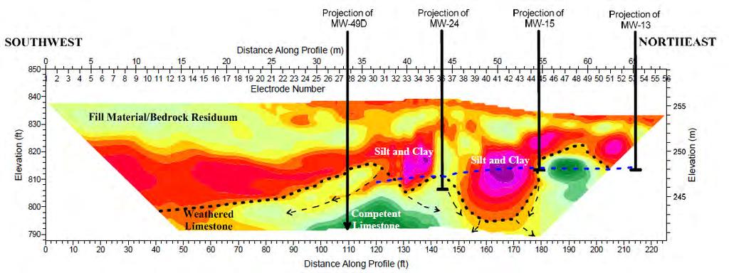
26 2D Electrical Resistivity Imaging System Once the apparent resistivity data is collected, it is modeled using an inversion technique which creates a true resistivity cross section Fill Materials/Bedrock Residuum Silt and Clay Competent Limestone Weathered Bedrock/Fracture Zone


27 Seismic Refraction and Surface Wave Methods Useful for mapping the top of bedrock, locating fracture zones and preferential pathways, and determining Vs30


28 Can Be Used in 2-D Or in 3-D


29 Shear Wave Velocity Studies 1-D Graphs for Determining Vs 30 2-D Profiles For Mapping Site Variability


30 Microgravity For mapping voids and severe fracture zones within bedrock. Very useful for locating mined areas within the upper 200 feet of the subsurface.

31 Microgravity Mapping Locates Missing Mass Such as From Mined Coal Seam Or From a Fractured/Weathered Zone in the Bedrock


32 Ground Penetrating Radar (GPR) Generally most applicable in coarse grained soils Excellent at imaging shallow metallic objects, structures, and geologic features Recent technical advances make rapid data collection possible


33 GPR Suitability Maps Show That GPR Isn t Always the Best Tool in the Toolbox

34 Individual GPR Profile This profile shows three UST s beneath reinforced concrete


35 Downhole Logging Commonly used to determine site geology and structural integrity of site wells Downhole view of casing Side view of wire wrapped screen

36 Thermal Imaging Used for mapping thermal variations due to burning or exothermic reactions
37 Practical Applications Environmental Site Assessments UST Search/Old Tank Pits Pipes and Utilities Site History/Fills Drum Disposal Areas
38 Industrial Site 400 ft by 300 ft Area History indicates possible environmental impacts location unknown Objective - find one 25 ft x 45 ft buried waste area within this 400 ft by 300 ft grid
, surely we will find and characterize our single chemical source")
39 Approach: Soil Borings Here are 150 randomly chosen sampling locations (borings), surely we will find and characterize our single chemical source area!
40 Oops! We missed!
41 We also missed these 11!

42 And these 9!
43 And these 13 too!
44 It would have taken a 20 ft by 20 ft geophysical survey grid to find the fill area.


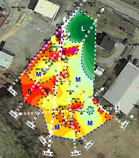
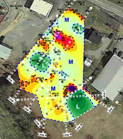
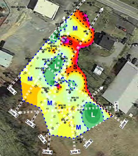
45 Single row, Perimeter Medium Density, Double Low Density, Center Single Row Cross Medium density, Center Low density, Meandering Medium density, target High density, target


46 High density, target High density, complete

47 High density, target High density, complete and accurate delineation

48 UST Search (EM-61 Channel Difference Map with GPR)

49 UST Search (EM-61 Channel Difference Map with GPR)

50 Site Mapping a Former MGP Site with EM-61 Geophysical Services Division Mundell & Associates, Inc.

51 Drum Search with EM-61


52 In The End, 4,000 Drums Were Discovered!


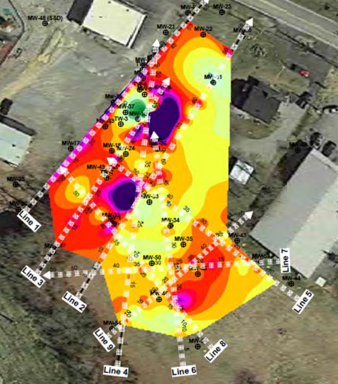
53 Site Mapping with Multiple Techniques EM-61 GPR (Shallow) GEM2 (Deep)

54 Delineating Fill Materials with EM Methods
55 Practical Applications Environmental Cont. Site Remediation Preferential Pathways Karst Mapping

56 Environmental Project in Kentucky SITE - 92/120 counties contain some areas of karst - 40 % of State is underlain by rocks with potential for karst - 20 % has well-developed karst features - Occurs in 4 principal regions

 Offsite")
57 UST Tank Pit Potential Extent of Impacts Gasoline impacts on/off site Free product random Variable depth to bedrock (10 to 40 ft) Offsite impacts

58 Geophysical Survey 2D Electrical Resistivity Phase I 4 Profile Lines PROFILE LINE 4

59 PROFILE LINE 1 PROFILE LINE 3

60 Geophysical Survey 2D Electrical Resistivity Phase I Summary Groundwater Flow Pathways


61 Geophysical Survey 2D Electrical Resistivity Phase II 5 Profile Lines
62 Resistivity Slice Map
63 Resistivity Slice Maps EL 815 EL 810 EL 805 EL 800 EL 795 EL 790


64 Resistivity Mapping Used to Locate Preferential Pathways and Guide the Placement of Bedrock Cores, Borehole Imaging, and Remedial Injections

65 Resistivity Mapping Used to Locate Preferential Pathways and Guide Remedial Injections


66 EM31 Survey Non-Metallic Field Tiles Detected Using Conductivity Mapping 11-acre Plume Impacted with Gasoline and Diesel Fuel Flow pathways along agricultural drainage tiles cut through clay soils within 10 ft of ground surface distributed gasoline across site.

67 Closing Remarks Numerous geophysical techniques available to help on any project Geophysical surveys yield increased confidence in finding buried targets and improving Conceptual Site Model Complimentary techniques allow for better overall characterization Remediation effectiveness improved to allow successful cleanups.
68 THANKS! Questions? John A. Mundell, P.E., L.P.G President/Director of Geophysical Services Ryan P. Brumbaugh, L.P.G. Project Geophysicist
Geophysical Exploration in Water Resources Assessment. John Mundell, P.E., L.P.G., P.G. Ryan Brumbaugh, L.P.G. Mundell & Associates, Inc.
 Geophysical Exploration in Water Resources Assessment John Mundell, P.E., L.P.G., P.G. Ryan Brumbaugh, L.P.G. Mundell & Associates, Inc. Presentation Objective Introduce the use of geophysical survey methods
Geophysics for Environmental and Geotechnical Applications
 Geophysics for Environmental and Geotechnical Applications Dr. Katherine Grote University of Wisconsin Eau Claire Why Use Geophysics? Improve the quality of site characterization (higher resolution and
High Resolution Geophysics: A Better View of the Subsurface. By John Jansen, P.G., Ph.D., Aquifer Science and Technology
 High Resolution Geophysics: A Better View of the Subsurface By John Jansen, P.G., Ph.D., Aquifer Science and Technology Geologist Use Only Part of the Information Available To Them Most Geologist rely
ambiguity in earth sciences IESO Geophysics Section Eddy hartantyo, Lab Geofisika FMIPA UGM
 ambiguity in earth sciences IESO Geophysics Section Eddy hartantyo, Lab Geofisika FMIPA UGM Pelatihan Tahap II IESO Teknik Geologi UGM Februari 2009 1 Introduction Photos from http://www.eegs.org/whatis/
Multimethod Geophysical Characterization of Fault Systems for Environmental Planning
 Multimethod Geophysical Characterization of Fault Systems for Environmental Planning John A. Mundell and Ryan P. Brumbaugh, Mundell & Associates, Inc. Brian Ham and Ric Federico, EnSafe Inc. Talk Outline
Case Study: University of Connecticut (UConn) Landfill
 Landfill") Case Study: University of Connecticut (UConn) Landfill Problem Statement:» Locate disposal trenches» Identify geologic features and distinguish them from leachate and locate preferential pathways in fractured
Case Study: University of Connecticut (UConn) Landfill Problem Statement:» Locate disposal trenches» Identify geologic features and distinguish them from leachate and locate preferential pathways in fractured
Aquitard Characterization The Legend of Indiana s Magic Clay Layer. Juliet Port, LPG #2214 July 2014
 Aquitard Characterization The Legend of Indiana s Magic Clay Layer Juliet Port, LPG #2214 July 2014 Topics What is an Aquitard? Why do we care? Review of Indiana glacial geology Conceptual Framework Investigation
EXTREMELY FAST IP USED TO DELINEATE BURIED LANDFILLS. Norman R. Carlson, Cris Mauldin Mayerle, and Kenneth L. Zonge
 EXTREMELY FAST IP USED TO DELINEATE BURIED LANDFILLS Norman R. Carlson, Cris Mauldin Mayerle, and Kenneth L. Zonge Zonge Engineering and Research Organization, Inc. 3322 East Fort Lowell Road Tucson, Arizona,
Use of Non-Invasive Near-Surface Geophysics for Managing Brine Releases
 Use of Non-Invasive Near-Surface Geophysics for Managing Brine Releases Presented by: Brent W. Barker, Staff Geophysicist Remediation Technologies Symposium 2012 Imagine the result Co-Authors Boyce L.
REPORT OF GEOPHYSICAL SURVEY
 REPORT OF GEOPHYSICAL SURVEY KARST IMAGING STUDY CADIZ INDUSTRIAL PARK CADIZ, TRIGG COUNTY, KY MUNDELL PROJECT NO. M NOVEMBER, South Downey Avenue, Indianapolis, Indiana - Telephone --, Facsimile -- www.mundellassociates.com
GEOPHYSICAL IMAGING TO ENHANCE ANALYSIS, DESIGN AND DRILLING OF LARGE-SCALE GEOTHERMAL SYSTEMS. Abstract
 GEOPHYSICAL IMAGING TO ENHANCE ANALYSIS, DESIGN AND DRILLING OF LARGE-SCALE GEOTHERMAL SYSTEMS John A. Mundell, Mundell & Associates, Inc., Indianapolis, Indiana Gabriel Hebert, Mundell & Associates, Inc.,
USE OF GEOPHYSICAL SURVEYS FOR FILL CHARACTERIZATION AND QUANTITY ESTIMATION AT BROWNFIELD SITES A CASE HISTORY. Abstract
 USE OF GEOPHYSICAL SURVEYS FOR FILL CHARACTERIZATION AND QUANTITY ESTIMATION AT BROWNFIELD SITES A CASE HISTORY John A. Mundell, Mundell & Associates, Inc., Indianapolis, IN Gregory B. Byer, Mundell &
Geophysics for Land Development
 Geophysics for Land Development About Us Whatever your area of interest GBGMAPS can provide advanced subsurface and structural geophysical solutions to add value to your product. Mining and infrastructure
CCR Rule Compliance: Innovative Use of Geophysics to Certify Landfill Stability and Site Groundwater Monitoring Wells
 CCR Rule Compliance: Innovative Use of Geophysics to Certify Landfill Stability and Site Groundwater Monitoring Wells Gary Pendergrass, PE, RG Principal Geological Engineer Missouri Waste Control Coalition
BUFFALO RIVER COALITION PO Box 101, Jasper, AR (870)
") BUFFALO RIVER COALITION PO Box 101, Jasper, AR 72641 (870) 446-5783 buffalowatershed@gmail.com Presentation before Arkansas Pollution Control and Ecology Commission, April 29, 2016 by Richard Mays on behalf
BUFFALO RIVER COALITION PO Box 101, Jasper, AR 72641 (870) 446-5783 buffalowatershed@gmail.com Presentation before Arkansas Pollution Control and Ecology Commission, April 29, 2016 by Richard Mays on behalf
Bedrock Characterization Mottolo Pig Farm Superfund Site
 Bedrock Characterization Mottolo Pig Farm Superfund Site Andrew Drew Hoffman, PE NH Department of Environmental Services andrew.hoffman@des.nh.gov 603.271.6778 1 Acknowledgments GZA GeoEnvironmental (lead
Table 5-1 Sampling Program Summary for Milltown Ford Avenue Redevelopment Area, NJ.
 Table 5- Sampling Program Summary for Milltown Ford Avenue Redevelopment Area, NJ. Transformer Pads (9 pads: PAD 9) Evaluate if PCBs presently exist in soils adjacent to, and/or beneath the transformer
LECTURE 10. Module 3 : Field Tests in Rock 3.6 GEOPHYSICAL INVESTIGATION
 LECTURE 10 3.6 GEOPHYSICAL INVESTIGATION In geophysical methods of site investigation, the application of the principles of physics are used to the study of the ground. The soil/rock have different characteristics
Geophysical Methods for Screening and Investigating Utility Waste Landfill Sites in Karst Terrain
 Geophysical Methods for Screening and Investigating Utility Waste Landfill Sites in Karst Terrain Gary Pendergrass, PE, RG, F.NSPE Principal Geological Engineer Kansas City Geotechnical Conference 2017
IMAGING OF DEEP SINKHOLES USING THE MULTI-ELECTRODE RESISTIVITY IMPLANT TECHNIQUE (MERIT) CASE STUDIES IN FLORIDA
 CASE STUDIES IN FLORIDA") IMAGING OF DEEP SINKHOLES USING THE MULTI-ELECTRODE RESISTIVITY IMPLANT TECHNIQUE (MERIT) CASE STUDIES IN FLORIDA David Harro The G3 Group, 2509 Success Drive, Suite 1, Odessa, FL 33556, david.harro@geo3group.com
IMAGING OF DEEP SINKHOLES USING THE MULTI-ELECTRODE RESISTIVITY IMPLANT TECHNIQUE (MERIT) CASE STUDIES IN FLORIDA David Harro The G3 Group, 2509 Success Drive, Suite 1, Odessa, FL 33556, david.harro@geo3group.com
Ground-Water Exploration in the Worthington Area of Nobles County: Summary of Seismic Data and Recent Test Drilling Results
 Ground-Water Exploration in the Worthington Area of Nobles County: Summary of Seismic Data and Recent Test Drilling Results Jim Berg and Todd Petersen Geophysicists, DNR Waters January 2000 Table of Contents
Sabal Trail Pipeline Project Evaluation of Karst Topography and Sinkhole Potential for Pipeline and Facilities
 November 11, 2014 Sabal Trail Pipeline Project Evaluation of Karst Topography and Sinkhole Potential for Pipeline and Facilities Gulf Interstate Engineering Attention: Mr. Denys Stavnychyi - Project Engineer
Development of geophysical investigation for verifying treatment efficiency of underground cavities
 Development of geophysical investigation for verifying treatment efficiency of underground cavities Hasan A. Kamal* Kuwait Institute for Scientific Research, Infrastructure Risk and Reliability Program,
FINAL REPORT GEOPHYSICAL INVESTIGATION VILLAGE ALHAMBRA RETENTION POND SITE THE VILLAGES, FLORIDA
 FINAL REPORT GEOPHYSICAL INVESTIGATION VILLAGE ALHAMBRA RETENTION POND SITE THE VILLAGES, FLORIDA Prepared for Andreyev Engineering, Inc. Oxford, FL Prepared by GeoView, Inc. St. Petersburg, FL August
KARST MAPPING WITH GEOPHYSICS AT MYSTERY CAVE STATE PARK, MINNESOTA
 KARST MAPPING WITH GEOPHYSICS AT MYSTERY CAVE STATE PARK, MINNESOTA By Todd A. Petersen and James A. Berg Geophysics Program Ground Water and Climatology Section DNR Waters June 2001 1.0 Summary A new
Pressure Grouting of Fractured Bedrock to Control Acid Mine Drainage
 WATER RESOURCES AT RISK May 14-18, 1995 Denver American Institute of Hydrology Pressure Grouting of Fractured Bedrock to Control Acid Mine Drainage S. A. Effner, G. D. Vandersluis, and V. Straskraba Hydro-Geo
BOS 100 Overburden and Bedrock Groundwater Remediation Former Dry Cleaning Facility
 BOS 100 Overburden and Bedrock Groundwater Remediation Former Dry Cleaning Facility Site Description Location Central Kentucky Site Use Retail Shopping Center Geologic Setting Inner Bluegrass Bedrock Ordovician
M E M O R A N D U M. Mr. Jonathan K. Thrasher, P.E. and Mr. Ian Kinnear, P.E. PSI
 M E M O R A N D U M TO: FROM: Mr. Mark Schilling Gulf Interstate Engineering Mr. Jonathan K. Thrasher, P.E. and Mr. Ian Kinnear, P.E. PSI DATE: November 11, 2014 RE: Summary of Findings Geotechnical Study
2-D Resistivity Study: The Horizontal Resolution Improvement by Introducing the Enhancing Horizontal Resolution (EHR) Technique
 Technique") Open Journal of Geology, 213, 3, 1-6 doi:1.4236/ojg.213.32b1 Published Online April 213 (http://www.scirp.org/journal/ojg) 2-D Resistivity Study: The Horizontal Resolution Improvement by Introducing the
Open Journal of Geology, 213, 3, 1-6 doi:1.4236/ojg.213.32b1 Published Online April 213 (http://www.scirp.org/journal/ojg) 2-D Resistivity Study: The Horizontal Resolution Improvement by Introducing the
Land Subsidence. Land subsidence is defined as the lowering of the land surface.
 Land Subsidence Land subsidence is defined as the lowering of the land surface. Many different factors can cause the land surface to subside. Subsidence can occur rapidly due to: a sinkhole or under ground
SEISMIC RADAR AND ELECTRICAL TECHNIQUES FOR WASTE DISPOSAL ASSESSMENT. M. Pipan, G. Dal Moro, E. Forte & M. Sugan
 SEISMIC RADAR AND ELECTRICAL TECHNIQUES FOR WASTE DISPOSAL ASSESSMENT M. Pipan, G. Dal Moro, E. Forte & M. Sugan Department of Geological, Environmental and Marine Sciences, University of Trieste Via Weiss,
Global Geophysical. Geophysical Service Solutions
 Geophysical Service Solutions is a geophysical consultancy firm specializing in providing geophysical solutions to appropriate mining, environmental and engineering problems. Site-appropriate geophysical
Integration of Seismic Refraction and 2D Electrical Resistivity in Locating Geological Contact
 Open Journal of Geology, 2013, 3, 7-12 doi:10.4236/ojg.2013.32b002 Published Online April 2013 (http://www.scirp.org/journal/ojg) Integration of Seismic Refraction and 2D Electrical Resistivity in Locating
Sabal Trail Pipeline Project Evaluation of Karst Topography and Sinkhole Potential for Pipeline and Facilities
 November 11, 2014 Sabal Trail Pipeline Project Evaluation of Karst Topography and Sinkhole Potential for Pipeline and Facilities Gulf Interstate Engineering Attention: Mr. Denys Stavnychyi - Project Engineer
FINAL REPORT GEOPHYSICAL INVESTIGATION WATER TOWER NO. 6 SITE PLANT CITY, FL
 APPENDIX B FINAL REPORT GEOPHYSICAL INVESTIGATION WATER TOWER NO. 6 SITE PLANT CITY, FL Prepared for Madrid Engineering Group, Inc. Bartow, FL Prepared by GeoView, Inc. St. Petersburg, FL February 28,
Geophysical Investigation of a 19th Century Archeological Site, Boston College K. Corcoran, J. Hager, M. Carnevale
 Geophysical Investigation of a 19th Century Archeological Site, Boston College K. Corcoran, J. Hager, M. Carnevale Hager GeoScience, Inc., Waltham, MA ------------------------------------------------------------------------
Background. Valley fills Sites in the Area. Construction over Mine Spoil Fills
 Construction over Mine Spoil Fills Wayne A. Karem, PhD, PE, PG, D.GE 2014 KSPE Annual Conference Background Strip mining; mountaintop and contour mining Creates huge quantities of mine spoil The mine spoil
Geophysics. Geotechnics. Geophysics. Earthworks. Environment. Groundwater. Rock Mechanics. Integrated Practical Solutions
 Geophysics Geotechnics Environment Groundwater Rock Mechanics Geophysics Earthworks Integrated Practical Solutions Geophysics Services Our 50 years of experience gained over 100,000 completed projects,
MOUNT POLLEY MINING CORPORATION TECHNICAL REPORT ON MULTI-ELECTRODE RESISTIVITY AND SEISMIC REFRACTION SURVEYS MOUNT POLLEY TAILINGS DAM PROJECT
 MOUNT PLEY MINING CORPORATION TECHNICAL REPORT ON MULTI-ELECTRODE RESISTIVITY AND SEISMIC REFRACTION SURVEYS MOUNT PLEY TAILINGS DAM PROJECT LIKELY, B.C. by Claudia Krumbiegel, M.Sc. Cliff Candy, P.Geo.
ENVIRONMENTAL AND ENGINEERING GEOPHYSICS
 ENVIRONMENTAL AND ENGINEERING GEOPHYSICS Environmental Engineering MSc 08/09 nd semester COURSE COMMUNICATION DOCUMENT University of Miskolc Faculty of Earth Science and Engineering Institute of Geophysics
J.H. Campbell Generating Facility Pond A - Location Restriction Certification Report
 J.H. Campbell Generating Facility Pond A - Location Restriction Certification Report Pursuant to: 40 CFR 257.60 40 CFR 257.61 40 CFR 257.62 40 CFR 257.63 40 CFR 257.64 Submitted to: Consumers Energy Company
Mitigation of Gypsum Mine Voids Under SR-2 in Ottawa County, Ohio
 Subsurface Investigation and Conceptual Alternatives Mitigation of Gypsum Mine Voids Under SR-2 in Ottawa County, Ohio Presented By: Ohio Department of Transportation CH2M HILL CTL Engineering Technos,
PART I A BRIEF SUMMARY OF SIX ROADWAY INVESTIGATIONS IN KARST
 METHODS USED TO CARRY OUT SIX ROADWAY INVESTIGATIONS OF SINKHOLES Richard C. Benson Technos, Inc. 3333 NW 21 st Street, Miami FL 33142 info@technos-inc.com ABSTRACT Karst conditions are a prevalent problem
Amistad Dam Investigation and Oversight: Karst- Founded Dam on the USA-Mexico Border
 Amistad Dam Investigation and Oversight: Karst- Founded Dam on the USA-Mexico Border Brook Brosi, CPG, PG USACE Lisa Nowicki Perks, PG USACE Kimberly Heenan, PE AECOM US Army Corps of Engineers BUILDING
GEOPHYSICAL SITE CHARACTERIZATION IN SUPPORT OF HIGHWAY EXPANSION PROJECT
 GEOPHYSICAL SITE CHARACTERIZATION IN SUPPORT OF HIGHWAY EXPANSION PROJECT * Shane Hickman, * Todd Lippincott, * Steve Cardimona, * Neil Anderson, and + Tim Newton * The University of Missouri-Rolla Department
MAPPING STRUCTURAL PATHWAYS FOR DNAPL TRANSPORT IN KARST USING INDUCED POLARIZATION
 MAPPING STRUCTURAL PATHWAYS FOR DNAPL TRANSPORT IN KARST USING INDUCED POLARIZATION Larry J. Hughes, EnSafe Inc., Memphis, TN Norman R. Carlson, Zonge Engineering & Research Organization, Inc., Tucson,
An Introduction to Field Explorations for Foundations
 An Introduction to Field Explorations for Foundations J. Paul Guyer, P.E., R.A. Paul Guyer is a registered mechanical engineer, civil engineer, fire protection engineer and architect with over 35 years
ELECTRICAL RESISTIVITY SURVEY OF INTREPID POTASH INJECTION WELL SITE: EDDY COUNTY, NEW MEXICO
 NCKRI REPORT OF INVESTIGATION 3 ELECTRICAL RESISTIVITY SURVEY OF INTREPID POTASH INJECTION WELL SITE: EDDY COUNTY, NEW MEXICO www.nckri.org NATIONAL CAVE AND KARST RESEARCH INSTITUTE REPORT OF INVESTIGATION
UTC R189 GEOPHYSICAL ASSESSMENT OF KARST ACTIVITY. Neil L. Anderson
 GEOPHYSICAL ASSESSMENT OF KARST ACTIVITY by Neil L. Anderson UTC R189 A University Transportation Center Program at Missouri University of Science & Technology Disclaimer The contents of this report reflect
IAEA SAFETY STANDARDS Geotechnical Aspects of Site Evaluation and Foundations in NPPs, NS-G-3.6
 IAEA SAFETY STANDARDS Geotechnical Aspects of Site Evaluation and Foundations in NPPs, NS-G-3.6 Regional Workshop on Volcanic, Seismic, and Tsunami Hazard Assessment Related to NPP Siting Activities and
1. Resistivity of rocks
 RESISTIVITY 1) Resistivity of rocks 2) General principles of resistivity surveying 3) Field procedures, interpretation and examples 4) Summary and conclusions INDUCED POLARIZATION 1) General principles
Geologging Imagery, Applications and Geological Interpretation. Shea Altadonna 1, Jim Fulton 2, E.I.T.
 Geologging Imagery, Applications and Geological Interpretation Shea Altadonna 1, Jim Fulton 2, E.I.T. 1 Geologist, Advanced Construction Techniques Inc. 1000 N. West St. Ste 1200, Wilmington, DE 19801;
Lecture 15: Subsidence
 Lecture 15: Subsidence Key Questions 1. How does removal of groundwater cause subsidence on a regional scale? 2. Under what conditions does a building sink into sediment? 3. Why do clays consolidate more
The fields of application of the Ground Penetrating Radar (GPR) are: CONSTRUCTION APPLICATIONS
 are: CONSTRUCTION APPLICATIONS") I.Industrial (technical) applications of geophysical methods used by the Archeo-geophysics laboratory in construction, plumbing, geotechnical engineering, engineering geology, mining, electricity power
I.Industrial (technical) applications of geophysical methods used by the Archeo-geophysics laboratory in construction, plumbing, geotechnical engineering, engineering geology, mining, electricity power
Although most karstic regions
 Urban Geophysics: Geophysical Signature of Mount Bonnell Fault and Its Karstic Features in Austin, TX by Mustafa Saribudak, Environmental Geophysics Associates, Austin, TX Although most karstic regions
FUNDAMENTALS OF ENGINEERING GEOLOGY
 FUNDAMENTALS OF ENGINEERING GEOLOGY Prof. Dr. HUSSEIN HAMEED KARIM Building and Construction Engineering Department 2012 Preface The impulse to write this book stemmed from a course of geology given by
Oak Ridge IFRC. Quantification of Plume-Scale Flow Architecture and Recharge Processes
 Oak Ridge IFRC Quantification of Plume-Scale Flow Architecture and Recharge Processes S. Hubbard *1, G.S. Baker *2, D. Watson *3, D. Gaines *3, J. Chen *1, M. Kowalsky *1, E. Gasperikova *1, B. Spalding
Site Characterization & Hydrogeophysics
 Site Characterization & Hydrogeophysics (Source: Matthew Becker, California State University) Site Characterization Definition: quantitative description of the hydraulic, geologic, and chemical properties
Geology 228/378 Applied and Environmental Geophysics Lecture 6. DC resistivity Surveys
 Geology 228/378 Applied and Environmental Geophysics Lecture 6 DC resistivity Surveys Direct current (DC) Resistivity. Introduction 2. Current flow in the ground 3. Schlumberger, Wenner, dipole-dipole,
Association of Environmental & Engineering Geologists (AEG) To join AEG: Student membership is Free! Ask about our scholarships.
 To join AEG: Student membership is Free! Ask about our scholarships.") Association of Environmental & Engineering Geologists (AEG) To join AEG: www.aegweb.org/join Student membership is Free! Ask about our scholarships. What is the Association of Environmental & Engineering
Association of Environmental & Engineering Geologists (AEG) To join AEG: www.aegweb.org/join Student membership is Free! Ask about our scholarships. What is the Association of Environmental & Engineering
Engineering Geophysical Application to Mine Subsidence Risk Assessment
 Engineering Geophysical Application to Mine Subsidence Risk Assessment By: Kanaan Hanna, Sr. Mining Engineer Steve Hodges, Sr. Geophysicist Jim Pfeiffer, Sr. Geophysicist Dr. Keith Heasley, Professor West
Major Points in Introduction
 Near- Surface Processes and Resources John Louie - louie@seismo.unr.edu eismo. unr.edu Thomas Pratt tpratt@ocean.washington.edu ashington.edu Here is a Laundry List- With it, we can prioritize Major Points
GPR AS A COST EFFECTIVE BEDROCK MAPPING TOOL FOR LARGE AREAS. Abstract
 GPR AS A COST EFFECTIVE BEDROCK MAPPING TOOL FOR LARGE AREAS Dr. Jutta L. Hager, Hager GeoScience, Inc., Waltham, MA Mario Carnevale, Hager GeoScience, Inc., Waltham, MA Abstract Hager GeoScience, Inc.
Application of geophysical results to designing bridge. over a large fault
 Application of geophysical results to designing bridge over a large fault Ho-Joon Chung 1, Jung-Ho Kim 2, Keun-Pil Park 2, Hyoung-Seok Kwon 1, Ho-Sik Choi 3, Ki-Seog Kim 4, Jong-Soo Kim 5 1 Manager, HeeSong
Before writing the discipline examinations, candidates must have passed, or have been exempted from, the Basic Studies Examinations.
 INTRODUCTION The Canadian Engineering Qualifications Board of Engineers Canada issues the Examination Syllabus that includes a continually increasing number of engineering disciplines. Each discipline
Site characterization at the Groundwater Remediation Field Laboratory
 Site characterization at the Groundwater Remediation Field Laboratory WILLIAM P. C LEMENT, STEVE CARDIMONA, ANTHONY L. ENDRES, Boston College, Boston, Massachusetts KATHARINE KADINSKY-CADE, Phillips Laboratory,
Groundwater in Bedrock Aquifers: Development Considerations
 Slide 1 Groundwater in Bedrock Aquifers: Development Considerations Pelham, New Hampshire October 3, 2016 Building Trust. Engineering Success. Slide 2 OUTLINE Background on groundwater in bedrock aquifers
GPR SURVEYS AT SOME 700 YEARS-OLD STRUCTURES IN THE OLD CITY OF CAIRO, EGYPT.
 GPR SURVEYS AT SOME 700 YEARS-OLD STRUCTURES IN THE OLD CITY OF CAIRO, EGYPT. Mohamed G. El-Behiry Geophysics Department, Faculty of Science, Cairo University, Giza, Egypt. Abstract Remediation and restoration
APPENDIX C GEOPHYSICAL REPORT
 APPENDIX C GEOPHYSICAL REPORT GEOPHYSICAL ENGINEERING SURVEY REPORT 700 E 241 st Street NOVA PROJECT NUMBER 15-0522 DATED January 27, 2015 PREPARED FOR: LANGAN Long Warf Maritime Center New Haven, CT 06511
Metallic Mineral Exploration in Minnesota: Typical Exploration Activities. Division of Lands and Minerals Minnesota Department of Natural Resources
 Metallic Mineral Exploration in Minnesota: Typical Exploration Activities Division of Lands and Minerals Minnesota Department of Natural Resources Metallic minerals can only be mined economically where
INNOVATIVE TECHNIQUES TO INVESTIGATE CONTAMINATION IN FRACTURED BEDROCK
 INNOVATIVE TECHNIQUES TO INVESTIGATE CONTAMINATION IN FRACTURED BEDROCK Abstract Christopher Gaule 1, Kenneth Goldstein 2, Grant Anderson 3 Watervliet Arsenal, located in Watervliet, New York, is the oldest
INTRODUCTION TO APPLIED GEOPHYSICS
 INTRODUCTION TO APPLIED GEOPHYSICS EXPLORING THE SHALL0W SUBSURFACE H. Robert Burger Anne F. Sheehan Craig H.Jones VERSITY OF COLORADO VERSITY OF COLORADO W. W. NORTON & COMPANY NEW YORK LONDON Contents
Electromagnetic Imaging (EMI) Representative Project Summaries
 Representative Project Summaries") Electromagnetic Imaging (EMI) Representative Project Summaries A Cost-Effective Tool for Site Characterization Marcellus Shale Water Group, LLC State College, PA Houston, TX Austin, TX Scanning the brain,
Electromagnetic Imaging (EMI) Representative Project Summaries A Cost-Effective Tool for Site Characterization Marcellus Shale Water Group, LLC State College, PA Houston, TX Austin, TX Scanning the brain,
Lima Project: Seismic Refraction and Resistivity Survey. Alten du Plessis Global Geophysical
 Lima Project: Seismic Refraction and Resistivity Survey Alten du Plessis Global Geophysical Report no 0706/2006 18 December 2006 Lima Project: Seismic Refraction and Resistivity Survey by Alten du Plessis
5 Further Case Histories
 5 Further Case Histories Chapter outline Cavity/old workings detection Detailed pillar detection Near-surface cavity detection Dyke, sill and fault detection In-seam disruptions (lenses, etc.) Coal thickness
SASKATCHEWAN STRATIGRAPHY GLACIAL EXAMPLE BOULDERS IN GLACIAL DEPOSITS
 SASKATCHEWAN STRATIGRAPHY GLACIAL EXAMPLE BOULDERS IN GLACIAL DEPOSITS 51 SASKATCHEWAN STRATIGRAPHY GLACIAL SURFICIAL STRATIFIED DEPOSITS 52 SASKATCHEWAN STRATIGRAPHY GLACIAL EXAMPLE OF SEDIMENT DEPOSITION
ELECTRICAL RESISTIVITY SURVEYS AT THE ANDERSON RESIDENCE SITE, PORT CLYDE, ME. For: St.Germain-Collins
 ELECTRICAL RESISTIVITY SURVEYS AT THE ANDERSON RESIDENCE SITE, PORT CLYDE, ME For: St.Germain-Collins 4 Union Street, Suite 3 Bangor, Maine 441 July, 218 ELECTRICAL RESISTIVITY SURVEYS AT THE ANDERSON
b Blackwell Science Environmental Geology PRINCIPLES AND PRACTICE
 Environmental Geology PRINCIPLES AND PRACTICE Fred G. Bell Department of Geology and Applied Geology University of Natal, Durban, South Africa b Blackwell Science Preface, ix 1 Introduction, 1 1.1 Planning
Finding Large Capacity Groundwater Supplies for Irrigation
 Finding Large Capacity Groundwater Supplies for Irrigation December 14, 2012 Presented by: Michael L. Chapman, Jr., PG Irrigation Well Site Evaluation Background Investigation Identify Hydrogeologic Conditions
INTEGRATED GEOPHYSICAL CHARACTERIZATION AT A CONTAMINATED SITE. Abstract
 INTEGRATED GEOPHYSICAL CHARACTERIZATION AT A CONTAMINATED SITE Mario Carnevale, Hager GeoScience, Inc., Woburn, MA Jutta Hager, Hager GeoScience, Inc., Woburn, MA Brian R. Jones, Hager GeoScience, Inc.,
Electrical Resistivity Survey for Delineating Seawater Intrusion in a Coastal Aquifer
 Electrical Resistivity Survey for Delineating Seawater Intrusion in a Coastal Aquifer Sung-Ho Song*, Gyu-Sang Lee*, Jin-Sung Kim*, Baekuk Seong*, Young-gyu Kim*, Myung-Ha Woo* and Namsik Park** Abstract
Geophysics Course Introduction to DC Resistivity
 NORAD supported project in MRRD covering Capacity Building and Institutional Cooperation in the field of Hydrogeology for Faryab Province Afghanistan Geophysics Course Introduction to DC Resistivity By
The Use of Vertical Electrical Sounding (VES) for Subsurface Geophysical Investigation around Bomo Area, Kaduna State, Nigeria
 for Subsurface Geophysical Investigation around Bomo Area, Kaduna State, Nigeria") IOSR Journal of Engineering (IOSRJEN) e-issn: 2250-3021, p-issn: 2278-8719 Vol. 3, Issue 1 (Jan. 2013), V4 PP 10-15 The Use of Vertical Electrical Sounding (VES) for Subsurface Geophysical Investigation
IOSR Journal of Engineering (IOSRJEN) e-issn: 2250-3021, p-issn: 2278-8719 Vol. 3, Issue 1 (Jan. 2013), V4 PP 10-15 The Use of Vertical Electrical Sounding (VES) for Subsurface Geophysical Investigation
Rotating Dual Axis Blending Technology at MGP Sites
 Applicability of ISCO Using Rotating Dual Axis Blending Technology at MGP Sites MGP 2012 March 28 30, 2012 Scott Tarmann AECOM ISCO at MGP Sites In-situ chemical oxidation (ISCO) has been used with varied
Wisconsin s Hydrogeology: an overview
 2012 Soil and Water Conservation Society Conference Stevens Point, WI Feb 9, 2012 Wisconsin s Hydrogeology: an overview Ken Bradbury Wisconsin Geological and Natural History Survey University of Wisconsin-Extension
Hazard Mapping Along the Dead Sea Shoreline
 FIG Working Week in Marrakech, Morocco 18-22 May 2011 Hazard Mapping Along the Dead Sea Shoreline Rami Al-Ruzouq, Abdullah Al-Zuobi, AbdEl-Rahman Abueladas, Emad Akkawi Department of Surveying and Geomatics
Assessing the Tier 2 Trigger for Fractured Sedimentary Bedrock Sites
 Assessing the Tier 2 Trigger for Fractured Sedimentary Bedrock Sites Ken Lyon, Jennifer Arnold, Louise Burden Advisian WorleyParsons Group RemTech 2015, October 16, Banff, AB INTRODUCTION High level look
Geological Models for Infrastructure Design:
 Geological Models for Infrastructure Design: Reducing Geotechnical Risk and Supporting Sustainability Alan Keith Turner Emeritus Professor of Geological Engineering CSM Visiting Research Associate - British
LIST OF FIGURES APPENDICES
 RESISTIVITY / INDUCED POLARIZATION SURVEY EL PORVENIR PROJECT MUNICIPALITY OF REMEDIOS, ANTIOQUIA, COLOMBIA LOGISTICS REPORT M-17427 APRIL 2017 TABLE OF CONTENTS Abstract... 1 1. The Mandate... 2 2. El
An Introduction to Applied and Environmental Geophysics
 An to Applied and Environmental Geophysics 2nd Edition John M. Reynolds Reynolds International Ltd Preface to the 2 na Edition Acknowledgements 1 1.1 1.2 1.3 1.4 1.5 What are 'applied' and 'environmental'
A surficial. P^HiHI waste disposal site, Bureau County, Illinois. east of the Sheffield low-level radioactive. electrical resistivity survey
 ISGS CONTRACT/GRANT REPORT 1981-6 WATER RESOURCES DIVISION/USGS P^HiHI 100240 557.09773 IL6cr 1981-6 A surficial electrical resistivity survey east of the Sheffield low-level radioactive waste disposal
DESIGN-PHASE GEOLOGIC FRAMEWORK MODELING FOR LARGE CONSTRUCTION PROJECTS
 DESIGN-PHASE GEOLOGIC FRAMEWORK MODELING FOR LARGE CONSTRUCTION PROJECTS Christine Vilardi, P.G., C.G.W.P. (vilardcl@stvinc.com, STV Inc., New York, New York) and Todd Kincaid, Ph.D. (Hazlett-Kincaid,
Beyond Rippability A Case History Integrating Seismic Refraction, Electrical Resistivity Imaging, and Geotechnical Boring Logs
 Beyond Rippability A Case History Integrating Seismic Refraction, Electrical Resistivity Imaging, and Geotechnical Boring Logs Jonathan B. Shawver 1 (jb@geovision.com), William Dalrymple 1 (will@geovision.com),
Gotechnical Investigations and Sampling
 Gotechnical Investigations and Sampling Amit Prashant Indian Institute of Technology Gandhinagar Short Course on Geotechnical Investigations for Structural Engineering 12 14 October, 2017 1 Purpose of
Airborne Geophysics to Map Groundwater. Bill Brown
 Airborne Geophysics to Map Groundwater Bill Brown bb@skytem.com A 6 borehole represents 1 millionth of an acre Aquifer Materials An aquifer is an underground layer of water bearing permeable rock, rock
GROUNDWATER PATHWAY MAPPING USING AIRBORNE GEOPHYSICS: TWO CASE STUDIES
 GROUNDWATER PATHWAY MAPPING USING AIRBORNE GEOPHYSICS: TWO CASE STUDIES Wayne Mandell 1, T. Jeffrey Gamey 2, William Doll 2 1 U.S. Army Environmental Center, Aberdeen Proving Ground, Maryland, 21010 (wayne.mandell@aec.apgea.army.mil)
CONTENTS 1. INTRODUCTION. 2. THE D.C. RESISTIVITY METHOD 2.1 Equipment 2.2 Survey Procedure 2.3 Data Reduction
 (i) CONTENTS 1. INTRODUCTION page 1 2. THE D.C. RESISTIVITY METHOD 2.1 Equipment 2.2 Survey Procedure 2.3 Data Reduction 3 3 3 3 3. GEOPHYSICAL RESULTS 3.1 General 3.2 Discussion 4 4 4 4. LIMITATIONS 5
GEOTECHNICAL ENGINEERING II. Subject Code : 06CV64 Internal Assessment Marks : 25 PART A UNIT 1
 GEOTECHNICAL ENGINEERING II Subject Code : 06CV64 Internal Assessment Marks : 25 PART A UNIT 1 1. SUBSURFACE EXPLORATION 1.1 Importance, Exploration Program 1.2 Methods of exploration, Boring, Sounding
IV. ENVIRONMENTAL IMPACT ANALYSIS G. GEOLOGY AND SOILS
 IV. ENVIRONMENTAL IMPACT ANALYSIS G. GEOLOGY AND SOILS The following section is a summary of the geotechnical report conducted for the proposed project. The Report of Geotechnical Investigation Proposed
Mustafa Saribudak Environmental Geophysics Associates, 2000 Cullen Avenue, Number 7, Austin, TX, 78757, USA,
 THE MILLION DOLLAR QUESTION: WHICH GEOPHYSICAL METHODS LOCATE CAVES BEST OVER THE EDWARDS AQUIFER? A POTPOURRI OF CASE STUDIES FROM SAN ANTONIO AND AUSTIN, TEXAS, USA Mustafa Saribudak Environmental Geophysics