Magnetic and Gravity Methods for Geothermal Exploration
|
|
|
- Merryl Reed
- 6 years ago
- Views:
Transcription
1 Magnetic and Gravity Methods for Geothermal Exploration Dr. Hendra Grandis Geophysics - ITB method and survey procedure Aero- or ground magnetic (covers a large area) Schlumberger resistivity mapping and sounding (concentrated in the area between broad magnetic low and high) self-potential (across high and low resistivity areas) gravity (covers low and high magnetic areas) expected anomaly low anomaly low anomaly high or low anomaly high or low anomaly interpretation Ql : can be associated with thermally altered zones Qt : geometry (?) Ql : can be associated with thermal fluids upflow and outflow zones Qt : shallow resistivity structure Ql : ascending thermal fluid (and / or descending cold water) Qt :? Ql : existence of deep structure, i.e. intrusive body or caldera structures Qt : geometry of those above (the upper structure must be closely defined) 1
2 method and survey procedure Thermal gradient and anomalous temperature (to figure out the cause of low resistivity layer) Magnetotelluric sounding micro-seismics (M< 3) expected anomaly high anomaly low anomaly high anomaly Ql : uprising or horisontal thermal fluid movement, if depth to resevoir is relatively shallow Qt : defined the upper structure Ql : can be associated with thermal fluids upflow and outflow zones Qt : deeper resistivity structure Ql : permeable zones Qt :? interpretation Probable sequence of geophysical exploration methods used to investigate young volcanic geothermal prospect (revised from Sudarman,, 1983) Magnetic Method Covers large area as regional reconnaissance (aero-mag mag,, + remote sensing) More local coverage (ground-mag mag) ) to search for demagnetized bodies associated with thermally altered zones Precaution for dipolar nature of magnetic anomalies Advanced processing for anomaly enhancement and modeling 2


3 Aero-magnetic Survey aero-magnetic data and interpretation 3


4 Ground-magnetic Survey Vectors of the Earth s s magnetic field 4
5 Dipolar anomaly related to inclined inducing main magnetic field Typical magnetic anomaly at low latitudes 5


6 Anomaly detected in N-S N S traverse over E-W E W anomalous body Reduction to Equator and Pole of Magnetic data A' B' C' Magnetic Anomaly Reduced to Equator Reduced to Pole A B C Frequency domain filtering process C A B C' A' B' prism position 6

7 Spectral analysis Depth and spatial extent of the anomalous sources are related to frequency or wavelength of the data low frequency / long wavelength ~ deep and regional anomalies high frequency / short wavelength ~ shallow and local anomalies information on depth of anomalous sources can be obtained from spectral analysis of potential filed data Wavelength or frequency and anomaly s s depth 7
8 Spectral analysis Calculate 2-D 2 D FFT and radially averaged spectra relationship between slope of power spectrum with depth filtering (low-pass, high-pass, band-pass) regional residual anomaly separation pseudo-depth depth slicing 10 deep 5 log power 0-5 intermediate shallow -10 noise wavenumber (cycle/km) Radially averaged spectra and line-fitted segments 8


9 Softwares for magnetic data processing and modeling Kamojang (Sungkono & Hochstein, 1995) 9
10 Wairakei,, NZ (Sungkono( & Hochstein, 1995) Gravity method g gravity data g 1 g 2 g 3 distance 10
11 Gravity Measurement We try to obtain exess or deficiency of gravity relative to normal gravity gravity anomaly difference between observed gravity and normal or theoretical gravity g ANOMALY = g OBSERVED - g THEORY must be corrected from factors affecting them Observed Gravity Use of relative gravimeter only measure m the difference of gravity values between two places measure gravity values at gravity stations relative to gravity base station (BS) BS St-1 R = R2 R1 g 1 = g BS + R R1 R2 known 11
 used for drift correction 12")
12 Gravity Base Station Local Base Station all stations gravity values are relative to this local Base Station tied or referenced to a higher order gravity Base Station (regional, national) used for drift correction 12
13 Factors Affecting Observed Gravity Instrumental drift correction determined by looping procedure, i.e base station measurement at the beginning and at the end of a survey Gravity Anomaly g ANOMALY = g OBSERVED g THEORY g OBSERVED gravity value relative to a known base station g THEORY Gravity Reference Field (GRF) corrected to meet the observation condition (elevation MSL) corrections: Free-Air, Bouguer,, Terrain 13
 (relative to a known Base)")
14 Gravity Data Processing Data Reduction Field gravity measurements must be corrected to account for several factors which effect the readings, also known as reducing the data Solid earth s s tide Instrumental drift Field readings Station s s Gravity (g obs ) (relative to a known Base) 14
15 Gravity Data Processing Gravity Correction Station s s Gravity must be corrected such that the values represent a perfect homogenous sphere, called a geoid.. If there are still differences in the readings after the corrections are made, then they may truly represent a gravity anomaly. Corrections Latitude, Free-air, Bouguer,, Terrain Gravity Correction Latitude correction Normal Gravity from International Gravity Formula 1967 g N (φ)) = ( sin 2 φ sin 2 2φ) g N (φ)) represents theoretical gravity at sea-level (reference), φ = latitude 15
16 Gravity Correction Free-air correction To compensate the height of gravity stations above sea-level (level of reference) g FA = h A h MSL Gravity Correction Bouguer correction To compensate the rock mass between sea-level to station s s elevation (level of reference). g B = ρ h Bouguer slab formula A h MSL 16
17 Gravity Correction Terrain correction To compensate the topography: existence of rock mass of hills (M1) and the inexistence of rock-mass in valleys (M2) g TC are obtained from table or calculated A M1 M2 MSL Gravity Correction Terrain correction M1 will decrease gravity value at A (negative vertical attraction), Bouguer correction considers that there is M2 so mass attraction equivalent to M2 must be extracted from values at A A M1 M2 MSL 17
18 Bouguer Anomaly Gravity corrections are applied to g N (φ), i.e. theoretical gravity at reference-level, to obtain theoretical gravity values at measurement stations g theor = g N (φ) g FA + g B g TC Bouguer Anomaly is the difference between observed Gravity and theoretical gravity g BA = g obs g theor = g obs g N (φ)) + g FA g B + g TC Bouguer Anomaly Gravity corrections do not bring (reduce) gravity values from stations elevation to the reference / sea-level Bouguer anomalies are values at stations elevation (A), not values at reference / sea- level A h MSL 18
19 Regional-Residual Residual Anomaly Separation Free-hand smoothing Grid (weighted) moving average Second Vertical Derivative (SVD) Polynomial surface fitting Spectral analysis based filtering Qualitative vs. Quantitative Anomaly enhancement Regional-Residual Residual Anomaly Separation Free-hand smoothing Profile Map 19
20 Regional-Residual Residual Anomaly Separation Grid (weighted) moving average related to SVD Regional-Residual Residual Anomaly Separation Second Vertical Derivative (SVD) 20

 moving")
21 Regional-Residual Residual Anomaly Separation Grid (weighted) moving average 21
22 ERROR: stackunderflow OFFENDING COMMAND: ~ STACK:
Geothermal Energy Resources Exploration using Gravity and magnetics. By Mariita, N.O. KenGen
 Geothermal Energy Resources Exploration using Gravity and magnetics By Mariita, N.O. KenGen What is Geothermal Energy? Geothermal Energy = heat from the Earth Transmitted by fluids via fractures and pores
Gravity data reduction
 Gravity data reduction REDUCTION: raw data à gravity anomaly data Temporal corrections tides and instrument drift Spatial corrections latitude and elevation GRS67 = gravity variation with latitude at sea
Geophysical Surveys of The Geothermal System of The Lakes District Rift, Ethiopia
 Geophysical Surveys of The Geothermal System of The Lakes District Rift, Ethiopia By: Befekadu Oluma By: Geophysics Department Geological Survey of Ethiopia The formation of the rift was preceded by a
Available online Journal of Scientific and Engineering Research, 2016, 3(2):1-7. Research Article
:1-7. Research Article") Available online www.jsaer.com, 2016, 3(2):1-7 Research Article ISSN: 2394-2630 CODEN(USA): JSERBR Assessment of the Reliability of Magnetic Method to Delineate Geologic Features in a Basement Complex:
Available online www.jsaer.com, 2016, 3(2):1-7 Research Article ISSN: 2394-2630 CODEN(USA): JSERBR Assessment of the Reliability of Magnetic Method to Delineate Geologic Features in a Basement Complex:
Last week we obtained a general solution: 1 cos αdv
 GRAVITY II Surface Gravity Anomalies Due to Buried Bodies Simple analytical solution may be derived for bodies with uniform density contrast simple shape, such as: Sphere Horizontal/vertical cylinders
C5 Magnetic exploration methods data analysis techniques
 C5 Magnetic exploration methods data analysis techniques C5.1 Data processing and corrections After magnetic field data have been collected a number of corrections are applied to simplify the interpretation.
 http://foundation.aapg.org/students/undergraduate/weeks.cfm Tim Carr - West Virginia University 3 Potential Fields Indirect Visualization Density and Magnetization Gravity and Magnetic Exploration Locate
Principles of Applied Geophysics
 Principles of Applied Geophysics Fifth edition D.S. Parasnis Professor emeritus of Applied Geophysics Department of Applied Geophysics, University ofluled, Lulea, Sweden Fellow of the Royal Swedish Academy
INTRODUCTION TO APPLIED GEOPHYSICS
 INTRODUCTION TO APPLIED GEOPHYSICS EXPLORING THE SHALL0W SUBSURFACE H. Robert Burger Anne F. Sheehan Craig H.Jones VERSITY OF COLORADO VERSITY OF COLORADO W. W. NORTON & COMPANY NEW YORK LONDON Contents
GRAVITY EXPLORATION (Gph 301) Chokri Jallouli 2014/2015
 Chokri Jallouli 2014/2015") KING SAUD UNIVERSITY FACULTY OF SCIENCES Department of Geology and Geophysics GRAVITY EXPLORATION (Gph 301) Chokri Jallouli 2014/2015 INTRODUCTION Definition Gravity method consists of measuring, studying
KING SAUD UNIVERSITY FACULTY OF SCIENCES Department of Geology and Geophysics GRAVITY EXPLORATION (Gph 301) Chokri Jallouli 2014/2015 INTRODUCTION Definition Gravity method consists of measuring, studying
Introduction to the use of gravity measurements in Ge111A
 Introduction to the use of gravity measurements in Ge111A Background & basic intuition Data reduction Use of the instrument See Reynolds for detailed quantitative discussion What and Why Gravity measures
MT Prospecting. Map Resistivity. Determine Formations. Determine Structure. Targeted Drilling
 MT Prospecting Map Resistivity Determine Formations Determine Structure Targeted Drilling Cross-sectional interpretation before and after an MT survey of a mineral exploration prospect containing volcanic
Total gravitational field is sum of contributions from all masses.
 Gravity force (acceleration) vs potential (energy) acceleration (g) => GM/r 2 Potential => - GM/r G is Newton s gravitational constant 6.67x10⁻¹¹ (S.I. units) you should determine what the S.I. units are
GRAVITY AND MAGNETIC SURVEY NECHAKO BASIN STUDY ACQUISITION AND PROCESSING PHASE
 GRAVITY AND MAGNETIC SURVEY NECHAKO BASIN STUDY ACQUISITION AND PROCESSING PHASE Report prepared for the B.C. Ministry of Energy and Mines Resource Development Division New Ventures Branch by Bemex Consulting
Geophysics for Geothermal Exploration
 Geophysics for Geothermal Exploration Dr. Hendra Grandis Geofisika - ITB Agenda Basic concept of Geophysics: : Review Geophysical signatures of a geothermal system Geophysical methods for geotermal exploration
Determination of Subsurface Bulk Density Distribution for Geotechnical Investigation using Gravity Technique
 Journal of Earth Sciences and Geotechnical Engineering, vol. 7, no.2, 2017, 63-69 ISSN: 1792-9040 (print), 1792-9660 (online) Scienpress Ltd, 2017 Determination of Subsurface Bulk Density Distribution
Work with Gravity Data in GM-SYS Profile
 Work with Gravity Data in GM-SYS Profile In GM-SYS Profile, a "Station" is a location at which an anomaly component is calculated and, optionally, was measured. In order for GM-SYS Profile to calculate
2.2 Gravity surveys. Gravity survey
 2.2 Gravity surveys Gravity survey The effect of latitude The effect of elevation The Bouguer effect Topographic effect The effect of tides Summary of corrections Gravity in boreholes Gravity survey In
PART A: Short-answer questions (50%; each worth 2%)
") PART A: Short-answer questions (50%; each worth 2%) Your answers should be brief (just a few words) and may be written on these pages if you wish. Remember to hand these pages in with your other exam pages!
PART A: Short-answer questions (50%; each worth 2%) Your answers should be brief (just a few words) and may be written on these pages if you wish. Remember to hand these pages in with your other exam pages!
Topic 7: Geophysical and Remote Sensing Models. Presenter: Greg Ussher Organisation:SKM
 Topic 7: Geophysical and Remote Sensing Models Presenter: Greg Ussher Organisation:SKM Email: gussher@globalskm.com Overview Surface-based imaging of subsurface characteristics That indicate geothermal
3. Magnetic Methods / 62
 Contents Preface to the Second Edition / xv Excerpts from Preface to the FirstEdition / xvii Mathematical Conventions / xix 1. Introduction / 1 Reference / 5 2. Gravity Methods / 6 2. I. Introduction /
CHAPTER X. Second Half Review 2017
 CHAPTER X Second Half Review 217 Here is a quick overview of what we covered in the second half of the class. Remember that the final covers the whole course but there will naturally be a bias towards
Integrated Geophysical Model for Suswa Geothermal Prospect using Resistivity, Seismics and Gravity Survey Data in Kenya
 Proceedings World Geothermal Congress 2015 Melbourne, Australia, 19-25 April 2015 Integrated Geophysical Model for Suswa Geothermal Prospect using Resistivity, Seismics and Gravity Survey Data in Kenya
GRAVITY AND MAGNETIC METHODS
 Presented at Short Course IX on Exploration for Geothermal Resources, organized by UNU-GTP, GDC and KenGen, at Lake Bogoria and Lake Naivasha, Kenya, Nov. 2-24, 2014. Kenya Electricity Generating Co.,
mdu G = Fdr = mgdr Dr. Clint Conrad POST 804 Gravity, the Geoid, and Mantle Dynamics Lecture: Gravity and the Geoid U G = G M r
 GG 611 Big Gulp Fall 2014 Gravity, the Geoid, and Mantle Dynamics Lecture: Gravity and the Geoid Dr. Clint Conrad POST 804 clintc@hawaii.edu Gravitational Potential For a point mass: Newton s law of gravitation:
Three-dimensional geophysical modelling of the Alalobeda geothermal field
 Three-dimensional geophysical modelling of the Alalobeda geothermal field Daniele Rizzello 1, Egidio Armadillo 2, Claudio Pasqua 2,3, Massimo Verdoya 2, Solomon Kebede 4, Andarge Mengiste 4, Getenesh H/Giorgis
Magnetotelluric (MT) Method
 Method") Magnetotelluric (MT) Method Dr. Hendra Grandis Graduate Program in Applied Geophysics Faculty of Mining and Petroleum Engineering ITB Geophysical Methods Techniques applying physical laws (or theory) to
Magnetotelluric (MT) Method Dr. Hendra Grandis Graduate Program in Applied Geophysics Faculty of Mining and Petroleum Engineering ITB Geophysical Methods Techniques applying physical laws (or theory) to
Note that gravity exploration is different to seismic exploration in the following way:
 224B3 Other factors that cause changes in g and need to be corrected Note that gravity exploration is different to seismic exploration in the following way: In a seismic survey, the travel time depends
5. Gravity. 5.1 Geoid Variations. The Australian Continent: A Geophysical Synthesis Gravity
 34 The Australian Continent: A Geophysical Synthesis Gravity 5. Gravity Gravity data map subtle changes in the Earth s gravitational field caused by variations in the density of the underlying materials.
Prof. Giuseppe Mandrone Prof. Cesare Comina dott. Luca Guglielmetti Dept. Earth Science, Univ. Torino (ITA)
") Prof. Giuseppe Mandrone Prof. Cesare Comina dott. Luca Guglielmetti Dept. Earth Science, Univ. Torino (ITA) Multidisciplinary approach of geothermal prospection at Terme di Vinadio/Valdieri (Cuneo - Italy):
Prof. Giuseppe Mandrone Prof. Cesare Comina dott. Luca Guglielmetti Dept. Earth Science, Univ. Torino (ITA) Multidisciplinary approach of geothermal prospection at Terme di Vinadio/Valdieri (Cuneo - Italy):
Gravity-Magnetic & Magneto-Telluric surveys in Purnea Onland Basin, India - A case history.
 P-281 Gravity-Magnetic & Magneto-Telluric surveys in Purnea Onland Basin, India - A case history. Summary A.K. Roy, D.P. Paine*, S. Sett, and H.N. Bhattacharya, ONGC This paper describes a case history
Introduction to the use of gravity measurements
 Introduction to the use of gravity measurements Background & basic intuition Data reduction Use of the instrument See Reynolds, Chpt 2, for detailed quantitative discussion What and Why Gravity measures
OUTLINE. Many of us secretly dream of six months without gravity COURSE DESCRIPTION
 GEOL 481.3 OUTLINE POTENTIAL FIELD METHODS GEOL 481.3 email: jim.merriam@usask.ca POTENTIAL FIELD METHODS Many of us secretly dream of six months without gravity Allan Fotheringham COURSE DESCRIPTION This
THE DEAD SEA RIFT VALLEY
 JOINT ISRAELI-PALESTINIAN GRAVITY SURVEY IN THE DEAD SEA RIFT VALLEY by M. Rybakov The Geophysical Institute of Israel P.O. Box 182 Lod, 7 1 100 Israel R El-Kelani Earth Sciences and seismic engineering
Imaging Reservoir Structure of Mt. Pancar Geothermal Prospect Using Audio-Frequency Magnetotelluric (AMT) and Gravity Technology
 and Gravity Technology") PROCEEDINGS, 42nd Workshop on Geothermal Reservoir Engineering Stanford University, Stanford, California, February 13-15, 2017 SGP-TR-212 Imaging Reservoir Structure of Mt. Pancar Geothermal Prospect Using
PROCEEDINGS, 42nd Workshop on Geothermal Reservoir Engineering Stanford University, Stanford, California, February 13-15, 2017 SGP-TR-212 Imaging Reservoir Structure of Mt. Pancar Geothermal Prospect Using
a z41. COMMONWEALTH OF AUSTRALIA DEPARTMENT OF NATIONAL DEVELOPMENT BUREAU OF MINERAL RESOURCES, GEOLOGY AND GEOPHYSICS RECORD 1961 No.
 a z41. COMMONWEALTH OF AUSTRALIA ff..4 *.re /Veis DEPARTMENT OF NATIONAL DEVELOPMENT BUREAU OF MINERAL RESOURCES, GEOLOGY AND GEOPHYSICS RECORD 1961 No. 66 RED TANK BORE GRAVITY SURVEY, PLENTY RIVER, N.T.
Gravitational constraints
 Gravitational constraints Reading: Fowler p172 187 Gravity anomalies Free-air anomaly: g F = g g( λ ) + δg obs F Corrected for expected variations due to the spheroid elevation above the spheroid Bouguer
1 The satellite altimeter measurement
 1 The satellite altimeter measurement In the ideal case, a satellite altimeter measurement is equal to the instantaneous distance between the satellite s geocenter and the ocean surface. However, an altimeter
An Introduction to Geophysical Exploration
 An Introduction to Geophysical Exploration Philip Kearey Department of Earth Sciences University of Bristol Michael Brooks Ty Newydd, City Near Cowbridge Vale of Glamorgan Ian Hill Department of Geology
BULLS-EYE! - SIMPLE RESISTIVITY IMAGING TO RELIABLY LOCATE THE GEOTHERMAL RESERVOIR
 BULLS-EYE! - SIMPLE RESISTIVITY IMAGING TO RELIABLY LOCATE THE GEOTHERMAL RESERVOIR Errol Anderson, Daryl Crosby and Greg Ussher PB Power GENZL Division, P O Box 3935, Auckland, New Zealand Key Words:
Lab 8: Gravity and Isostasy (35 points)
") it's not the most important thing in your life right now. But what is important is gravity. Arnold Schwarzenegger as Colonel John Matrix, Commando (Check out this classic of American cinema!) Lab 8: Gravity
it's not the most important thing in your life right now. But what is important is gravity. Arnold Schwarzenegger as Colonel John Matrix, Commando (Check out this classic of American cinema!) Lab 8: Gravity
RELATIONSHIP BETWEEN GEOTHERMAL ACTIVITY AND GRAVITY ANOMALIES ON VULCANO ISLAND, ITALY
 Proceedings NZ Geothermal Workshop 2002 RLATIONSHIP BTWN GOTHRMAL ACTIVITY AND GRAVITY ANOMALIS ON VULCANO ISLAND, ITALY M. S.OKUMA', S.NAKANO', R. FURUKAWA', M. KOMAZAWA' & R. SUPPR 2 'Geological Survey
GRAVIMETRIC MAP OF CHILE. Services Mining and Engineering Geophysics Instituto Geográfico Militar
 GRAVIMETRIC MAP OF CHILE Araneda M., Rivas L., Avendaño M, Sottolichio G., Rubio W. Services Mining and Engineering Geophysics segmi@netexpress.cl) Instituto Geográfico Militar (lrivas@igm.cl) Abstract
APPLICATION OF GEOPHYSICS TO GEOTHERMAL ENERGY EXPLORATION AND MONITORING OF ITS EXPLOITATION
 Presented at Short Course III on Exploration for Geothermal Resources, organized by UNU-GTP and KenGen, at Lake Naivasha, Kenya, October 24 - November 17, 2008. GEOTHERMAL TRAINING PROGRAMME Kenya Electricity
Getting Started: Using and Understanding Gravity Data
 The University of Texas at El Paso Pan-American Center for Earth and Environmental Studies Thu 13-Sep-2007 ABOUT PACES Mission Newsletter Sponsors RESEARCH Geoinformatics Remote Sensing Geoscience GIS
Department of Geophysics Faculty of Earth Sciences King Abdulaziz University
 Department of Geophysics Faculty of Earth Sciences King Abdulaziz University Dr. Mansour A. Al-Garni Office: room 233/Buld. 27 OR Dept. chair office/buld. 55 Introduction to Geophysics EGP 211 Time: 10-10:55
Geophysics for Environmental and Geotechnical Applications
 Geophysics for Environmental and Geotechnical Applications Dr. Katherine Grote University of Wisconsin Eau Claire Why Use Geophysics? Improve the quality of site characterization (higher resolution and
GEOTHERMAL POTENTIAL OF ST. KITTS AND NEVIS ISLANDS
 GEOTHERMAL POTENTIAL OF ST. KITTS AND NEVIS ISLANDS By Gerald W. Huttrer Geothermal Management Company, Inc. For the Eastern Caribbean Geothermal Energy Project ( Geo- Caraibes ; G-C ) Presented Using
Geology 228/378 Applied and Environmental Geophysics Lecture 6. DC resistivity Surveys
 Geology 228/378 Applied and Environmental Geophysics Lecture 6 DC resistivity Surveys Direct current (DC) Resistivity. Introduction 2. Current flow in the ground 3. Schlumberger, Wenner, dipole-dipole,
INTERGRATED GEOPHYSICAL METHODS USED TO SITE HIGH PRODUCER GEOTHERMAL WELLS
 Presented at Short Course VII on Exploration for Geothermal Resources, organized by UNU-GTP, GDC and KenGen, at Lake Bogoria and Lake Naivasha, Kenya, Oct. 27 Nov. 18, 2012. GEOTHERMAL TRAINING PROGRAMME
r 1 r 2 r 3 Dr is what matters!
 Today s Agenda Gravity - Background & basic intuition - Data reduction - Use of the instrument - See textbook for detailed quantitative discussion - Measure height of Millikan or S. Mudd What and Why Gravity
September 16, 2010 Magnetic surveying
 September 16, 2010 Magnetic surveying After today, you will be able to Sketch anomalies over objects at any location, and explain how you derived the pattern. Explain the relation between dipoles and real
ENV-5004B/ENVK5005B. Figure 6. Student Registration No. ENV-5004B/ENVK5005B Version 2
 ENV-5004B/ENVK5005B Figure 6 Student Registration No UNIVERSITY OF EAST ANGLIA School of Environmental Sciences Main Series UG Examination 014-15 SOLID EARTH GEOPHYSICS SOLID EARTH GEOPHYSICS WITH FIELDCOURSE
SPECTRAL ANALYSIS OF GROUND MAGNETIC DATA IN MAGADI AREA, SOUTHERN KENYA RIFT
 SPECTRAL ANALYSIS OF GROUND MAGNETIC DATA IN MAGADI AREA, SOUTHERN KENYA RIFT 1 JG Githiri, 2 JP Patel, 3 JO Barongo and 4 PK Karanja 1 Jomo-Kenyatta University of Agriculture, Science and Technology,
Geophysical surveys Anomaly maps 2D modeling Discussion Conclusion
 Introduction Geophysical surveys Anomaly maps 2D modeling Discussion Conclusion General context Growth of volcanic domes is a multiphase process: extrusion phases 2005 lava dome growth inside the Mount
Hendra Grandis 1 and Prihadi Sumintadireja 2
 A BRIEF REVIEW FOR THE PROPER APPLICATION OF MAGNETOTELLURIC (MT) AND CONTROLLED-SOURCE AUDIO-FREQUENCY MAGNETOTELLURIC (CSAMT) IN GEOTHERMAL EXPLORATION Hendra Grandis 1 and Prihadi Sumintadireja 2 ABSTRACT
224 D4 Instrumentation and data collection techniques for magnetic exploration
 224 D4 Instrumentation and data collection techniques for magnetic exploration D4.1 Instrumentation D4.1.1 Flux gate magnetometer Details of operation are described in Keary and Brooks Measures the component
Last Time. Today s s Agenda. Geophysics. Geophysics. Geophysics. MAS 603: Geological Oceanography. Lecture 21: Geophysics 1: Gravity
 UNIVERSITY OF SOUTH ALABAMA Last Time MAS 603: Geological Oceanography Extinctions Lecture 21: 1: http://www.cartoonstock.com/newscartoons/cartoonists/for/lowres/forn441l.jpg Today s s Agenda Introduction
Geophysics and Mapping. presented by: Stephen Brown
 Geophysics and Mapping presented by: Stephen Brown Recommended book for INIGEMM Geophysics for the mineral exploration geoscientist, by Michael Dentith and Stephen Mudge, Cambridge University Press, 2014.
Euler Deconvolution JAGST Vol. 15(1) 2013
 2013") Euler Deconvolution JAGST Vol. 15(1) 2013 2D-EULER DECONVOLUTION AND FORWARD MODELING OF GRAVITY DATA OF HOMA-HILLS GEOTHERMAL PROSPECT, KENYA A. Odek 1, A. B. Otieno 1, W. J. Ambusso 1 and J. G. Githiri
Euler Deconvolution JAGST Vol. 15(1) 2013 2D-EULER DECONVOLUTION AND FORWARD MODELING OF GRAVITY DATA OF HOMA-HILLS GEOTHERMAL PROSPECT, KENYA A. Odek 1, A. B. Otieno 1, W. J. Ambusso 1 and J. G. Githiri
Global geophysics and wave propagation
 Global geophysics and wave propagation Reading: Fowler p76 83 Remote sensing Geophysical methods Seismology Gravity and bathymetry Magnetics Heat flow Seismology: Directly samples the physical properties
Isostacy: Compensation of Topography and Isostatic Geoid Anomalies
 Isostacy: Compensation of Topography and Isostatic Geoid Anomalies November 3, 2016 1 Isostacy One of the major goals of interpreting planetary gravity fields is to understand how topography positive (
Exploration of Geothermal High Enthalpy Resources using Magnetotellurics an Example from Chile
 Exploration of Geothermal High Enthalpy Resources using Magnetotellurics an Example from Chile Ulrich Kalberkamp, Federal Institute for Geosciences and Natural Resources (BGR), Stilleweg 2, 30655 Hannover,
Introduction. Matlab output for Problems 1 2. SOLUTIONS (Carl Tape) Ge111, Assignment #3: Gravity April 25, 2006
 Ge111, Assignment #3: Gravity April 25, 2006") SOLUTIONS (Carl Tape) Ge111, Assignment #3: Gravity April 25, 26 Introduction The point of this solution set is merely to plot the gravity data and show the basic computations. This document contains a
SOLUTIONS (Carl Tape) Ge111, Assignment #3: Gravity April 25, 26 Introduction The point of this solution set is merely to plot the gravity data and show the basic computations. This document contains a
Keywords: geophysics field camp, low to moderate, temperature, geothermal system, Mt Pancar, Indonesia
 Proceedings World Geothermal Congress 2015 Melbourne, Australia, 19-25 April 2015 Geophysics Field Camp (GFC): A Student Project Aimed to Investigate the Low to Moderate Temperature Geothermal System in
A Note on the Use of the Second Vertical Derivative (SVD) of Gravity Data with Reference to Indonesian Cases
 of Gravity Data with Reference to Indonesian Cases") J. Eng. Technol. Sci., Vol. 50, No. 1, 018, 17-139 17 A Note on the Use of the Second Vertical Derivative (SVD) of Gravity Data with Reference to Indonesian Cases Prihadi Sumintadireja 1, Darharta Dahrin
J. Eng. Technol. Sci., Vol. 50, No. 1, 018, 17-139 17 A Note on the Use of the Second Vertical Derivative (SVD) of Gravity Data with Reference to Indonesian Cases Prihadi Sumintadireja 1, Darharta Dahrin
 SHEET TITLE: DRAWN BY: J.M.CLARK FILE NO. CHECKED BY: W.S. JORDAN APPROVED BY: DATE: FIGURE SHEET TITLE: DRAWN BY: J.M.CLARK FILE NO. CHECKED BY: W.S. JORDAN APPROVED BY: DATE: FIGURE SPOTLIGHT Technical
ENVI.2030L - Plate Tectonics - Geomagnetism, Earthquakes, and Gravity
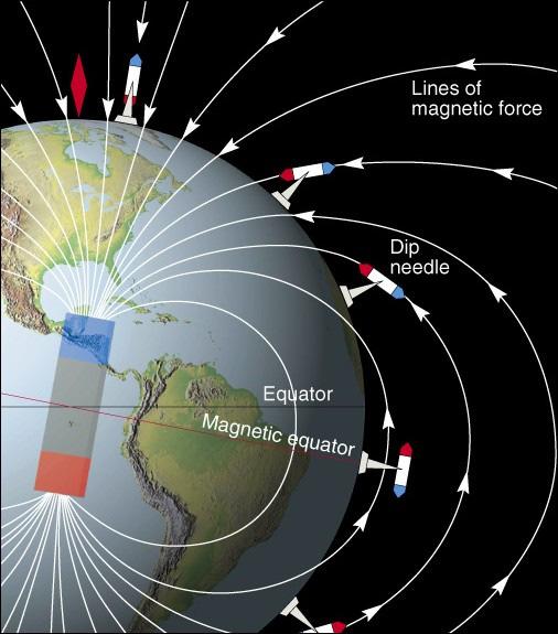
 I. Geomagnetism Name ENVI.2030L - Plate Tectonics - Geomagnetism, Earthquakes, and Gravity The earth's magnetic field can be viewed as a simple bar magnet located near the center of the earth and inclined
Estimation of Subsurface Structure in the Western Fukuoka City fromgravity Data
 Available online at www.sciencedirect.com Procedia Earth and Planetary Science 6 ( 2013 ) 163 168 Estimation of Subsurface Structure in the Western Fukuoka City fromgravity Data 1Taiki ARIMA, 2 Yasuhiro
KEYSTONE PROPERTY GRAVITY GIS DATABASE. Residual Gravity Looking Down to Northwest
 KEYSTONE PROPERTY GRAVITY - 2018 GIS DATABASE Residual Gravity Looking Down to Northwest James L. Wright M.Sc. May 11, 2018 TABLE OF CONTENTS INTRODUCTION......................... 2 SURVEY PROCEDURE......................
GRAVITY MEASUREMENTS IN THE BEAUFORT SEA AREA*
 50 Papers GRAVITY MEASUREMENTS IN THE BEAUFORT SEA AREA* Donald Plouff G Introduction RAVITY and other geophysical measurements (Plouff et al. 96) were made on Fletcher s Ice Island (T-) as part of studies
FORWARD MODELING OF THE GEOID ANOMALY USING SPHERICAL HARMONICS: APPLICATIONS IN THE SIERRA NEVADA. Alissa C Scire
 FORWARD MODELING OF THE GEOID ANOMALY USING SPHERICAL HARMONICS: APPLICATIONS IN THE SIERRA NEVADA by Alissa C Scire A Prepublication Manuscript Submitted to the Faculty of the DEPARTMENT OF GEOSCIENCES
A NEW GLOBAL CRUSTAL MODEL BASED ON GOCE DATA GRIDS
 A NEW GLOBAL CRUSTAL MODEL BASED ON GOCE DATA GRIDS M. Reguzzoni, D. Sampietro DIIAR Politecnico di Milano CRUSTAL MODELS SEISMIC MODEL SEISMIC AND GRAVITY Moho model from Meier et al. 2007; unit [km].
Pseudo 3d Gravity Modeling to Determine Intrusion Contact of Parang Area, Karangsambung, Central java, Jndonesia
 2012 International Conference on Geological and Environmental Sciences IPCBEE vol.3 6(2012) (2012)ICSIT Press, Singapoore Pseudo 3d Gravity Modeling to Determine Intrusion Contact of Parang rea, Karangsambung,
Magnetic Case Study: Raglan Mine Laura Davis May 24, 2006
 Magnetic Case Study: Raglan Mine Laura Davis May 24, 2006 Research Objectives The objective of this study was to test the tools available in EMIGMA (PetRos Eikon) for their utility in analyzing magnetic
Heat (& Mass) Transfer. conceptual models of heat transfer. large scale controls on fluid movement. distribution of vapor-saturated conditions
 Transfer. conceptual models of heat transfer. large scale controls on fluid movement. distribution of vapor-saturated conditions") Heat (& Mass) Transfer conceptual models of heat transfer temperature-pressure gradients large scale controls on fluid movement distribution of vapor-saturated conditions fluid flow paths surface manifestations
Heat (& Mass) Transfer conceptual models of heat transfer temperature-pressure gradients large scale controls on fluid movement distribution of vapor-saturated conditions fluid flow paths surface manifestations
OZ SEEBASE TM. Datasets. Digital Elevation Model
 Digital Elevation Model 10 Digital Elevation Models (DEM s) often show the youngest structures, and any active geological structures. They are widely used for neotectonic analysis. The composition of eroding
Overview of Indonesian Geothermal System
 Overview of Indonesian Geothermal System The Resources Beyond High Enthalpy Magmatic/Volcanic Systems By Dr.Eng. Suryantini ITB 4/3/2017 1 Outline Current Condition of Indonesian Geothermal Resources and
Overview of geophysical methods used in geophysical exploration
 Overview of geophysical methods used in geophysical exploration Lúdvík S. Georgsson United Nations University Geothermal Training Programme Orkustofnun Reykjavík ICELAND The role of the geophysicist Measuring
SURVEI GRAVITI (Gravity Surveying)
") Introduction SURVEI GRAVITI (Gravity Surveying) Gravity surveys measure the acceleration due to gravity, g. Average value of g at Earth s surface is 9.80 ms -2. Gravitational attraction depends on density
Introduction SURVEI GRAVITI (Gravity Surveying) Gravity surveys measure the acceleration due to gravity, g. Average value of g at Earth s surface is 9.80 ms -2. Gravitational attraction depends on density
GEOID UNDULATIONS OF SUDAN USING ORTHOMETRIC HEIGHTS COMPARED WITH THE EGM96 ANG EGM2008
 GEOID UNDULATIONS OF SUDAN USING ORTHOMETRIC HEIGHTS COMPARED Dr. Abdelrahim Elgizouli Mohamed Ahmed* WITH THE EGM96 ANG EGM2008 Abstract: Positioning by satellite system determine the normal height above
GEOPHYSICAL STUDY OF THE NORTHERN PART OF TE KOPIA GEOTHERMAL FIELD, TAUPO VOLCANIC ZONE, NEW ZEALAND
 Proceedings 20th Geothermal Workshop 1998 GEOPHYSICAL STUDY OF THE NORTHERN PART OF TE KOPIA GEOTHERMAL FIELD, TAUPO VOLCANIC ZONE, NEW ZEALAND Institute, The University of Auckland, Auckland, SUMMARY
Geophysics Course Introduction to DC Resistivity
 NORAD supported project in MRRD covering Capacity Building and Institutional Cooperation in the field of Hydrogeology for Faryab Province Afghanistan Geophysics Course Introduction to DC Resistivity By
Preliminary Microgravity Measurement Of Paka Geothermal Prospect
 Preliminary Microgravity Measurement Of Paka Geothermal Prospect Presented by: Levi Shako and Calistus Ndongoli Date: 4/November/2016 Venue: Addis Ababa, Ethiopia Introduction Microgravity is a geophysical
HIMALAYAN AIRBORNE GRAVITY AND GEOID OF NEPAL
 Mt. Everest HIMALAYAN AIRBORNE GRAVITY AND GEOID OF NEPAL -Niraj Manandhar Head, Geodetic Survey Branch Survey Department, Geodetic Survey Branch Project Background Air Borne Gravity Survey Project was
Section 2: Gravity Surveying
 Introduction Section 2: Gravity Surveying Gravity surveys measure the acceleration due to gravity, g. Average value of g at Earth s surface is 9.80 ms -2. Gravitational attraction depends on density of
CONTENTS PREFACE. VII 1. INTRODUCTION VARIOUS TOPICS IN SEISMOLOGY TECTONICS PERTAINING TO EQ PREDICTION 5
 CONTENTS PREFACE. VII 1. INTRODUCTION.... 1 2. VARIOUS TOPICS IN SEISMOLOGY TECTONICS PERTAINING TO EQ PREDICTION 5 2.1. Spatial distribution of strong EQs. 5 2.1.1. Mapping of major seismic fracture zones
GM 1.4. SEG/Houston 2005 Annual Meeting 639
 storage recovery project in Leyden, Colorado Kristofer Davis *, Yaoguo Li, Michael Batzle, and Bob Raynolds** Center for Gravity, Electrical, and Magnetic Studies, Department of Geophysics, Colorado School
Japan Engineering Consultants, Inc., Energy and Industrial Technology Development Organization,Tokyo, Japan
 DEEP GEOTHERMAL STRUCTURE AND THE HYDROTHERMAL SYSTEM THE GEOTHERMAL FIELD, JAPAN M. H. K. MATSUDA', T. K. Japan Engineering Consultants, Inc., Japan Energy and Industrial Technology Development Organization,Tokyo,
High Resolution Geophysics: A Better View of the Subsurface. By John Jansen, P.G., Ph.D., Aquifer Science and Technology
 High Resolution Geophysics: A Better View of the Subsurface By John Jansen, P.G., Ph.D., Aquifer Science and Technology Geologist Use Only Part of the Information Available To Them Most Geologist rely
3D Modeling for exploration
 3D Modeling for exploration Tero Niiranen Acting Division Manager Bedrock and Resources, GTK Rovaniemi office 02.05.2014 1 3D modeling supporting exploration in GTK Visualizing data in 3D world 3D geophysical
Horizontal gradient and band-pass filter of aeromagnetic data image the subsurface structure; Example from Esh El Mellaha Area, Gulf of Suez, Egypt.
 Horizontal gradient and band-pass filter of aeromagnetic data image the subsurface structure; Example from Esh El Mellaha Area, Gulf of Suez, Egypt. Essam Aboud 1, Serguei Goussev 2, Hassan Hassan 2, Suparno
Iwan Yandika Sihotang, Tommy Hendriansyah, Nanang Dwi Ardi
 Proceedings Indonesia International Geothermal Convention & Exhibition 2014 Jakarta Convention Center, Indonesia 4-6 June 2014 FOCAL MECHANISM FOR DETERMINING FAULT PLANES ORIENTATION IN GAMMA GEOTHERMAL
GRACE Gravity Model GGM02
 GRACE Gravity Model GGM02 The GGM02S gravity model was estimated with 363 days (spanning April 2002 through December 2003) of GRACE K-band range-rate, attitude, and accelerometer data. No Kaula constraint,
Geophysical Methods in Geothermal Exploration
 Geochemical and Geophysical Methodologies in Geothermal Exploration Geophysical Methods in Geothermal Exploration by Adele Manzella Italian National Research Council International Institute for Geothermal
Gravity Methods (IV)
") Environmental and Exploration Geophysics II Gravity Methods (IV) tom.h.wilson tom.wilson@mail.wvu.edu Department of Geology and Geography West Virginia University Morgantown, WV Possible employment opportunities
Environmental and Exploration Geophysics II Gravity Methods (IV) tom.h.wilson tom.wilson@mail.wvu.edu Department of Geology and Geography West Virginia University Morgantown, WV Possible employment opportunities
QUALITATIVE INTERPRETATION OF POTENTIAL FIELD PROFILES: SOUTHERN NECHAKO BASIN
 QUALITATIVE INTERPRETATION OF POTENTIAL FIELD PROFILES: SOUTHERN NECHAKO BASIN By Melvyn E. Best Bemex Consulting International 5288 Cordova Bay Road Victoria, B.C. V8Y 2L4 KEYWORDS: potential fields,
INTEGRATED GEOPHYSICAL STUDIES OF THE ULUBELU GEOTHERMAL FIELD, SOUTH SUMATERA, INDONESIA
 ITEGATED GEOPHYSICAL STUDIES OF THE ULUBELU GEOTHEMAL FIELD, SOUTH SUMATEA, IDOESIA Yunus Daud 1, Sayogi Sudarman 2, Keisuke Ushijima 1 1 Exploration Geophysics Lab., Fac. of Engineering, Kyushu University,
TERRAIN (BOUGUER) DENSITY. One of the largest effects on gravity is the attraction of the topography near the
 DENSITY. One of the largest effects on gravity is the attraction of the topography near the") TERRAIN (BOUGUER) DENSITY One of the largest effects on gravity is the attraction of the topography near the gravity station. This is distinct from the Bouguer correction, which corrects for the attraction
TERRAIN (BOUGUER) DENSITY One of the largest effects on gravity is the attraction of the topography near the gravity station. This is distinct from the Bouguer correction, which corrects for the attraction
A33 The Challenge for Surface Passive Seismic Measurements in Kuwait
 A33 The Challenge for Surface Passive Seismic Measurements in Kuwait G.R. Rached* (Kuwait Oil Company) SUMMARY Surface passive seismic is a direct hydrocarbon saturation indicator technology. It detects