|
|
|
- Gerald Willis
- 5 years ago
- Views:
Transcription

1

2 Tim Carr - West Virginia University
3 3 Potential Fields Indirect Visualization Density and Magnetization Gravity and Magnetic Exploration Locate Faults and Other Structures Petroleum, Geothermal, Mineral and Water Resources Relatively Inexpensive Cover Large Areas Ground and Airborne
4 Mean value about 9.8 m/sec 2 = 1 g About 0.5% smaller at equator than poles Map unit = gal (for Galileo) = 1 cm/sec 2 Mean gravity = 980 gal Maps contoured in mgal = 10-6 g Modern gravimeters can detect.001 mgal variations (= 1 ppb) A gravimeter is essentially a spring balance. 4
5 5


6 6
7 Centrifugal force (3400 mgal at equator) Variation of Earth s radius g(φ) = 9.78( sin 2 φ sin 2 2φ) 0.5% less at equator than pole = 5000 mgal At 45⁰ = 58 mgal/degree 7
8 Raw Gravity Latitude Corrections Altitude Mass between observer and sea level Thickness of Crust and Regional Variations Purpose is to identify features of geologic interest, not cancel everything out 8
9 9 Gravity decreases 0.31 mgal/m A correction for altitude only is a free-air correction However, there is also mass between the observer and sea level A correction for excess mass is a Bouguer correction
10 Gravity varies by latitude due to earth s equatorial bulge and centrifugal force Need altitude correction = 0.3 mgal/m = 3 x 10⁻⁷ g/m Altitude only correction = Free-Air Anomaly Map Correct for mass between you and sea level = Bouguer Anomaly Map May also need terrain corrections Correct for variations in thickness of crust = Isostatic Anomaly Map 10
11 11
12 12
13 13
14 14
15 15 Earth with topography Geoid: Ideal sea-level shape of the earth Eliminate topography but keep the gravity Gravity is what determines orbits and leveling of survey instruments How do we know where the sea would be at some point inland? Datum: Ellipsoid that best fits the geoid Sphere: Globes and simple projections
16 16 Simple corrections for latitude and altitude Density = Lithology Can sense deep into crust Gravimeters are basically sensitive spring balances Fragile Prone to drift Discrete data points Labor intensive, low detail
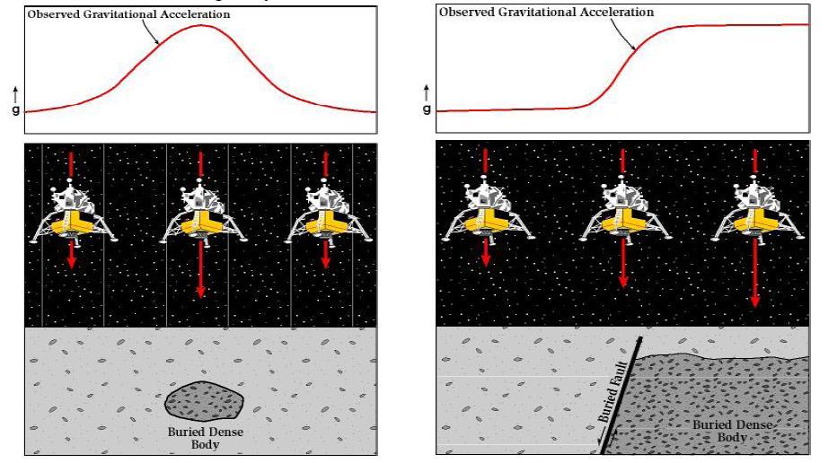
17 Locations of anomaly sources are constrained Shapes of anomaly sources are constrained Sources cannot have geologically absurd properties Maximum depths are constrained Total masses constrained 17
18 18
19 19

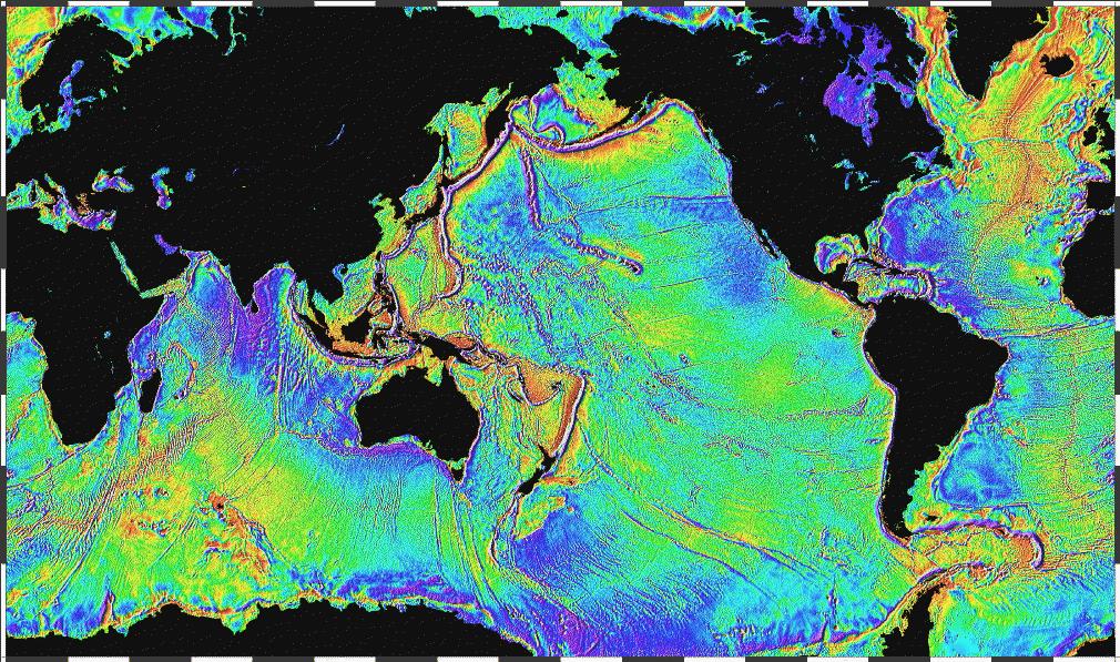
20 Contours at 5 mgal intervals, Color bands at 10 mgal intervals. 20

21 Contours at 5 mgal intervals, Color bands at 10 mgal intervals. 21
22 22

23 23
24 24
25 25

26 GSA Today, January,

27 27 Gravity GM-SYS Profile model of salt structure integrating seismic reflection, FTG gravity, and magnetic data (EarthExplorer, 2009).

28 Diamagnetism: weak repulsion from electron orbital motion, all materials Paramagnetism: moderate attraction due to unpaired electrons Ferromagnetism: strong attraction due to parallel alignment of electrons 28
29 29 Magnetic field of Earth = 40 micro-tesla = 40,000 nano-tesla (= 40,000 gamma) Varies from 25 to 70 micro-tesla Non-axial Not centered on the earth Varies over a human lifetime
30 Ferromagnetism is due to parallel electron magnetic moments Organization breaks down under heating Most materials lose magnetism around 500 C Can t pick up red hot iron with a magnet Responsible for most paleomagnetism Magnetic anomalies must be shallow Geomagnetic field has some other origin 30
31 Magnetic Minerals Magnetite Pyrrhotite Ilmenite Magnetite requires intermediate O activity Too much O Hematite Too little O Fe silicates Complex: Al favors biotite over Fe oxides No simple tie to lithology 31
32 Core is electrically conducting fluid Electric currents in core create magnetic field Motion of conducting fluid creates electric currents Currents generate magnetic field. Probable driver: convection Rotation affects flow and field orientation 32


33 33
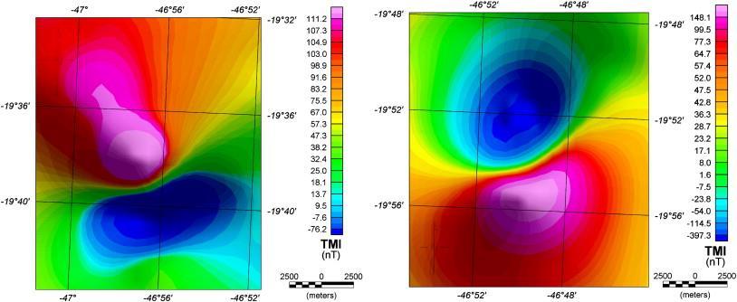
34 34
35 35 Units nanoteslas nt Main field 60,000 to 30,000 nt Core dynamo External field 10 s nt Diurnal, seasonal, ionization of atmosphere solar wind currents, storms Anomalous field 1000 s nt Magnetic susceptibility of crust
36 36 Corrections are complex and time variable No simple correlation with lithology Can t sense deep into crust because heat destroys magnetism Magnetism is electromagnetic phenomenon Instruments can be purely electronic Can record continuously Can be extremely detailed
37 37
38 38
39 39

40 magnetic material below adds magnetism and creates positive anomaly magnetic rocks include iron ore, gabbro, granite 40

41 Removal of magnetic material from near surface causes negative anomaly (example is normal faulting) 41

42 Contours at 100-nT intervals, Color bands at 200 nt intervals. 42
 Bodies with anomalous density or magnetic susceptibility are modeled/interpreted Courtesy of")
43 Instruments measure the local gravity and magnetic field Data are processed to highlight local anomalies (residual maps) Bodies with anomalous density or magnetic susceptibility are modeled/interpreted Courtesy of ExxonMobil 43
44 44
 of the Eastern")

45 45 Residual gravity map (200km high pass) of the Eastern Mediterranean basin. Interpreted crustal type and key basement fabric.

46 Gravity, magnetic and seismic model for profile from Crete to Saudi Arabia. 46
47 47 Gravity maps Mechanical Instrument Discrete readings Less detail Can sense to great depths Simple corrections for latitude and elevation Density correlates with rock type Magnetic Maps Instruments are purely electronic Continuous readings Great detail Can sense only a few kilometers deep Complex corrections in time and space No simple correlation with rock type
48 Potential Fields Are Valuable Exploration Tools Gravity Magnetics Density and Magnetic Properties Some Ambiguity Low Cost Earth Model Valuable for Processing of Seismic Data 48
")
49 49 Assignments Complete All Homework Discuss Current Energy Events Read Today in Energy for Tuesday (3/31) at Be Prepared to Discuss in Class - Wednesday Discussion Leader Connor Faccone Test Wednesday April 8 Material Through Monday (4/6) will be on Test
GRAVITY AND MAGNETIC METHODS
 Presented at Short Course IX on Exploration for Geothermal Resources, organized by UNU-GTP, GDC and KenGen, at Lake Bogoria and Lake Naivasha, Kenya, Nov. 2-24, 2014. Kenya Electricity Generating Co.,
Magnetism.
 Magnetism Magnetism https://twistedsifter.files.wordpress.com/2012/05/visualizing-magnetic-fields-with-iron-filings-2.jpg?w=800&h=600 Magnets Are dipoles as opposed to monopoles + - + Referred to as North
ENVI.2030L - Plate Tectonics - Geomagnetism, Earthquakes, and Gravity
 I. Geomagnetism Name ENVI.2030L - Plate Tectonics - Geomagnetism, Earthquakes, and Gravity The earth's magnetic field can be viewed as a simple bar magnet located near the center of the earth and inclined
Introduction to the use of gravity measurements in Ge111A
 Introduction to the use of gravity measurements in Ge111A Background & basic intuition Data reduction Use of the instrument See Reynolds for detailed quantitative discussion What and Why Gravity measures
Last week we obtained a general solution: 1 cos αdv
 GRAVITY II Surface Gravity Anomalies Due to Buried Bodies Simple analytical solution may be derived for bodies with uniform density contrast simple shape, such as: Sphere Horizontal/vertical cylinders
Introduction to the use of gravity measurements
 Introduction to the use of gravity measurements Background & basic intuition Data reduction Use of the instrument See Reynolds, Chpt 2, for detailed quantitative discussion What and Why Gravity measures
GRAVITY EXPLORATION (Gph 301) Chokri Jallouli 2014/2015
 Chokri Jallouli 2014/2015") KING SAUD UNIVERSITY FACULTY OF SCIENCES Department of Geology and Geophysics GRAVITY EXPLORATION (Gph 301) Chokri Jallouli 2014/2015 INTRODUCTION Definition Gravity method consists of measuring, studying
KING SAUD UNIVERSITY FACULTY OF SCIENCES Department of Geology and Geophysics GRAVITY EXPLORATION (Gph 301) Chokri Jallouli 2014/2015 INTRODUCTION Definition Gravity method consists of measuring, studying
Last Time. Today s s Agenda. Geophysics. Geophysics. Geophysics. MAS 603: Geological Oceanography. Lecture 21: Geophysics 1: Gravity
 UNIVERSITY OF SOUTH ALABAMA Last Time MAS 603: Geological Oceanography Extinctions Lecture 21: 1: http://www.cartoonstock.com/newscartoons/cartoonists/for/lowres/forn441l.jpg Today s s Agenda Introduction
GE 2400 Test #2 3/26/03. Name
 GE 2400 Test #2 3/26/03 Name 9. Fill in the blank. a. minerals have a negative magnetic susceptibility. b. Ground surveys that use gradiometer magnetometers generally measure the. c. Horizontal derivatives
Exploration Geophysics
 Exploration Geophysics Bearbeitet von Mamdouh R. Gadallah, Ray Fisher. Auflage 2008. Buch. xxii, 266 S. Hardcover ISBN 978 3 540 8559 2 Format (B x L): 5,5 x 23,5 cm Gewicht: 649 g Weitere Fachgebiete
Magnetic and Gravity Methods for Geothermal Exploration
 Magnetic and Gravity Methods for Geothermal Exploration Dr. Hendra Grandis Geophysics - ITB method and survey procedure Aero- or ground magnetic (covers a large area) Schlumberger resistivity mapping and
Geomagnetics. Magnetic Surveying
 Geomagnetics ieso 2010 Magnetic Surveying The investigation of the subsurface geology on the basis of anomalies in the Earth s magnetic field resulting from the magnetic properties of the causative body.
mdu G = Fdr = mgdr Dr. Clint Conrad POST 804 Gravity, the Geoid, and Mantle Dynamics Lecture: Gravity and the Geoid U G = G M r
 GG 611 Big Gulp Fall 2014 Gravity, the Geoid, and Mantle Dynamics Lecture: Gravity and the Geoid Dr. Clint Conrad POST 804 clintc@hawaii.edu Gravitational Potential For a point mass: Newton s law of gravitation:
r 1 r 2 r 3 Dr is what matters!
 Today s Agenda Gravity - Background & basic intuition - Data reduction - Use of the instrument - See textbook for detailed quantitative discussion - Measure height of Millikan or S. Mudd What and Why Gravity
CHAPTER X. Second Half Review 2017
 CHAPTER X Second Half Review 217 Here is a quick overview of what we covered in the second half of the class. Remember that the final covers the whole course but there will naturally be a bias towards
2.2 Gravity surveys. Gravity survey
 2.2 Gravity surveys Gravity survey The effect of latitude The effect of elevation The Bouguer effect Topographic effect The effect of tides Summary of corrections Gravity in boreholes Gravity survey In
GEOL.3250 Geology for Engineers Plate Tectonics - Geomagnetism, Earthquakes, and Gravity
 Name GEOL.3250 Geology for Engineers Plate Tectonics - Geomagnetism, Earthquakes, and Gravity I. Geomagnetism The earth's magnetic field can be viewed as a simple bar magnet located near the center of
Gravity data reduction
 Gravity data reduction REDUCTION: raw data à gravity anomaly data Temporal corrections tides and instrument drift Spatial corrections latitude and elevation GRS67 = gravity variation with latitude at sea
Note that gravity exploration is different to seismic exploration in the following way:
 224B3 Other factors that cause changes in g and need to be corrected Note that gravity exploration is different to seismic exploration in the following way: In a seismic survey, the travel time depends
Magnetic field nomenclature
 Magnetic field nomenclature Declination trend angle between horizontal projection of F and true North Inclination plunge angle between horizontal and F Magnetic equator location on surface where field
Total gravitational field is sum of contributions from all masses.
 Gravity force (acceleration) vs potential (energy) acceleration (g) => GM/r 2 Potential => - GM/r G is Newton s gravitational constant 6.67x10⁻¹¹ (S.I. units) you should determine what the S.I. units are
Geophysics Physics of the Earth
 Geophysics 210 - Physics of the Earth Final exam Section GEOPH 210 Lecture A01 Instructor Dr. Martyn Unsworth Date Friday December 12 th 2008 Time allowed 9:00 a.m. noon Total = 104 points Please attempt
Geophysics 223 January Geophysics 223 C1: Basics of Geomagnetism. C1.1 Introduction
 Geophysics 223 C1: Basics of Geomagnetism C1.1 Introduction Lodestone was known to the Greeks (800 BC) and Chinese (300 BC) First compass (200 BC) made by Chinese, but not clear why it worked Europeans
Geophysics 210 D1: Basics of Geomagnetism. D1.1 Introduction
 Geophysics 210 D1: Basics of Geomagnetism D1.1 Introduction Lodestone was known to the Greeks (800 BC) and Chinese (300 BC) First compass (200 BC) made by Chinese, but not clear why it worked Europeans
Ch2&3 Test. Multiple Choice Identify the choice that best completes the statement or answers the question.
 Ch2&3 Test Multiple Choice Identify the choice that best completes the statement or answers the question. 1. Earth s circumference is about 40,000 km, and its shape is a. an oval. c. a perfect sphere.
Chapter 9. ASTRONOMY 202 Spring 2007: Solar System Exploration. Class 26: Planetary Geology [3/23/07] Announcements.
![Chapter 9. ASTRONOMY 202 Spring 2007: Solar System Exploration. Class 26: Planetary Geology [3/23/07] Announcements.](/thumbs/87/96235120.jpg "Chapter 9. ASTRONOMY 202 Spring 2007: Solar System Exploration. Class 26: Planetary Geology [3/23/07] Announcements.") ASTRONOMY 202 Spring 2007: Solar System Exploration Instructor: Dr. David Alexander Web-site: www.ruf.rice.edu/~dalex/astr202_s07 Class 26: Planetary Geology [3/23/07] Announcements Planetary Geology Planetary
ASTRONOMY 202 Spring 2007: Solar System Exploration Instructor: Dr. David Alexander Web-site: www.ruf.rice.edu/~dalex/astr202_s07 Class 26: Planetary Geology [3/23/07] Announcements Planetary Geology Planetary
OCN 201: Seafloor Spreading and Plate Tectonics I
 OCN 201: Seafloor Spreading and Plate Tectonics I Revival of Continental Drift Theory Kiyoo Wadati (1935) speculated that earthquakes and volcanoes may be associated with continental drift. Hugo Benioff
GRAVITY AND GRAVITY ANOMALIES Newtonian Gravitation
 Gravity Exploration GRAVITY AND GRAVITY ANOMALIES Newtonian Gravitation Gravity: force of attraction between objects with mass Consider two objects with mass m 1 and m 2 : m 1 m 2 F g F g distance (r)
Planetary Interiors. Earth s Interior Structure Hydrostatic Equilibrium Heating Constituent Relations Gravitational Fields Isostasy Magnetism
 Planetary Interiors Earth s Interior Structure Hydrostatic Equilibrium Heating Constituent Relations Gravitational Fields Isostasy Magnetism Hydrostatic Equilibrium First order for a spherical body: Internal
Geophysics for Environmental and Geotechnical Applications
 Geophysics for Environmental and Geotechnical Applications Dr. Katherine Grote University of Wisconsin Eau Claire Why Use Geophysics? Improve the quality of site characterization (higher resolution and
OZ SEEBASE TM. Datasets. Digital Elevation Model
 Digital Elevation Model 10 Digital Elevation Models (DEM s) often show the youngest structures, and any active geological structures. They are widely used for neotectonic analysis. The composition of eroding
Intro to magnetic methods
 Environmental and Exploration Geophysics I Intro to magnetic methods tom.h.wilson tom.wilson@mail.wvu.edu Department of Geology and Geography West Virginia University Morgantown, WV Items on the list Gravity
Getting Started: Using and Understanding Gravity Data
 The University of Texas at El Paso Pan-American Center for Earth and Environmental Studies Thu 13-Sep-2007 ABOUT PACES Mission Newsletter Sponsors RESEARCH Geoinformatics Remote Sensing Geoscience GIS
Earth. Properties of Earth. Earth's Interior. Earth is the planet that we know best
 Earth Earth is the planet that we know best Our observations of the other planets are all compared to the conditions and properties of Earth Properties of Earth Semimajor Axis Orbital Eccentricity Orbital
Civilization exists by geologic consent, subject to change without notice William Durant
 89.325 Geology for Engineers Plate Tectonics Civilization exists by geologic consent, subject to change without notice William Durant Properties of the Planets Size Density Distance from sun Chemistry
Chapter 12 Lecture. Earth: An Introduction to Physical Geology. Eleventh Edition. Earth s Interior. Tarbuck and Lutgens Pearson Education, Inc.
 Chapter 12 Lecture Earth: An Introduction to Physical Geology Eleventh Edition Earth s Interior Tarbuck and Lutgens Earth s Internal Structure Earth s interior can be divided into three major layers defined
Gravitational constraints
 Gravitational constraints Reading: Fowler p172 187 Gravity anomalies Free-air anomaly: g F = g g( λ ) + δg obs F Corrected for expected variations due to the spheroid elevation above the spheroid Bouguer
MINERAL EXPLORATION UNDER DEEP COVER. Neil Williams School of Earth & Environmental Sciences
 MINERAL EXPLORATION UNDER DEEP COVER Neil Williams School of Earth & Environmental Sciences The problem Discovery rates, especially of world-class deposits, have fallen significantly over the past 15-20
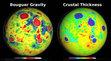
Information on internal structure from shape, gravity field and rotation
 Information on internal structure from shape, gravity field and rotation Seismological information is available only for the Earth and in limited amounts for the Moon. Various geodetic data put constraints
GRAVITY AND MAGNETIC SURVEY NECHAKO BASIN STUDY ACQUISITION AND PROCESSING PHASE
 GRAVITY AND MAGNETIC SURVEY NECHAKO BASIN STUDY ACQUISITION AND PROCESSING PHASE Report prepared for the B.C. Ministry of Energy and Mines Resource Development Division New Ventures Branch by Bemex Consulting
Winmeen Tnpsc Group 1 & 2 Self Preparation Course Physics UNIT 10. Magnetism
 Physics UNIT 10 Magnetism The word magnetism is derived from iron ore magnetite (Fe3O4), which was found in the island of magnesia in Greece. It was Gilbert who laid the foundation for magnetism and had
C5 Magnetic exploration methods data analysis techniques
 C5 Magnetic exploration methods data analysis techniques C5.1 Data processing and corrections After magnetic field data have been collected a number of corrections are applied to simplify the interpretation.
Lecture 19: Magnetic properties and the Nephelauxetic effect
 Lecture 19: Magnetic properties and the Nephelauxetic effect sample balance thermometer connection to balance left: the Gouy balance for Gouy Tube determining the magnetic susceptibility of materials north
2-D potential field modeling across the Hawtmi and Wiahatya faults in search of geothermal resources within the Umatilla Indian Reservation
 2-D potential field modeling across the Hawtmi and Wiahatya faults in search of geothermal resources within the Umatilla Indian Reservation Grober, Benjamin L. 1 & Palmer, Zachary A. 1 1 U.S. Geological
Which Earth latitude receives the greatest intensity of insolation when Earth is at the position shown in the diagram? A) 0 B) 23 N C) 55 N D) 90 N
 0 B) 23 N C) 55 N D) 90 N") 1. In which list are the forms of electromagnetic energy arranged in order from longest to shortest wavelengths? A) gamma rays, x-rays, ultraviolet rays, visible light B) radio waves, infrared rays, visible
1. In which list are the forms of electromagnetic energy arranged in order from longest to shortest wavelengths? A) gamma rays, x-rays, ultraviolet rays, visible light B) radio waves, infrared rays, visible
The Geodynamo and Paleomagnetism Brown and Mussett (1993) ch. 6; Fowler p
 ch. 6; Fowler p") In this lecture: The Core The Geodynamo and Paleomagnetism Brown and Mussett (1993) ch. 6; Fowler p. 32-50 Problems Outer core Physical state Composition Inner core Physical state Composition Paleomagnetism
In this lecture: The Core The Geodynamo and Paleomagnetism Brown and Mussett (1993) ch. 6; Fowler p. 32-50 Problems Outer core Physical state Composition Inner core Physical state Composition Paleomagnetism
Geothermal Energy Resources Exploration using Gravity and magnetics. By Mariita, N.O. KenGen
 Geothermal Energy Resources Exploration using Gravity and magnetics By Mariita, N.O. KenGen What is Geothermal Energy? Geothermal Energy = heat from the Earth Transmitted by fluids via fractures and pores
Global Tectonics. Kearey, Philip. Table of Contents ISBN-13: Historical perspective. 2. The interior of the Earth.
 Global Tectonics Kearey, Philip ISBN-13: 9781405107778 Table of Contents Preface. Acknowledgments. 1. Historical perspective. 1.1 Continental drift. 1.2 Sea floor spreading and the birth of plate tectonics.
3D potential-field inversions and alteration mapping in the Gawler Craton and Curnamona Province, South Australia
 3D potential-field inversions and alteration mapping in the Gawler Craton and Curnamona Province, South Australia Richard Chopping, Nick Williams, Tony Meixner and Indrajit Roy Outline Inversions Introduction
Origin of the Oceans II. Earth A Living Planet. Earthquakes and Volcanoes. Plate Tectonics II
 Origin of the Oceans II Plate Tectonics II Earth A Living Planet Heat of formation of the planet is trapped at center, gradually escaping Center is nickel and iron Earthquakes and Volcanoes 1 Tracing the
Intro to magnetic methods
 Environmental and Exploration Geophysics I Intro to magnetic methods tom.h.wilson tom.wilson@mail.wvu.edu Department of Geology and Geography West Virginia University Morgantown, WV Items on the list 6.5
224 D4 Instrumentation and data collection techniques for magnetic exploration
 224 D4 Instrumentation and data collection techniques for magnetic exploration D4.1 Instrumentation D4.1.1 Flux gate magnetometer Details of operation are described in Keary and Brooks Measures the component
Environmental and Exploration Geophysics I Gravity I tom.h.wilson
 Environmental and Exploration Geophysics I Gravity I tom.h.wilson tom.wilson@mail.wvu.edu Department of Geology and Geography West Virginia University Morgantown, WV Discuss mid term exam Objectives for
CHAPTER FOUR GEOPHYSICAL INTERPRETATION AND DISCUSSION
 CHAPTER FOUR GEOPHYSICAL INTERPRETATION AND DISCUSSION 4.1. DATA PROCESSING AND INTERPRETATION 4.1.1. Introduction Processing of potential field data entails the application of various filters to the data
Grade 8 Learning Objectives MS-PS2-4.
 MS-PS2-4. Construct and present arguments using evidence to support the claim that gravitational interactions are attractive and depend on the masses of interacting objects. [Clarification Statement: Examples
The Gulf of Mexico - From Various Vantage Points John E. Bain, Kenton J. Hamilton
 The Gulf of Mexico - From Various Vantage Points John E. Bain, Kenton J. Hamilton Oftentimes in exploration geophysics we tend to focus on specific near-term exploration prospects, as dictated by the current
Magnetism. Magnets Source of magnetism. Magnetic field. Magnetic force
 Magnetism Magnets Source of magnetism Magnetic field Magnetic force Magnets and magnetic force Historical First magnets were pieces of iron-bearing rock called loadstone (magnetite, Fe 3 O 4 ) found originally
scale Three-dimensional Modelling
 Lithospheric-scale scale Three-dimensional Modelling (Application to the EARS and Plateau) Girma Woldetinsae (Geological Survey of Ethiopia) and H.-J. Götze R. Hackney S. Schmidt (Institut für Geowissenschaften
Chapter 14. Optical and Magnetic Materials. 경상대학교 Ceramic Design Lab.
 Chapter 14 Optical and Magnetic Materials Magnetic field strength = H H = Ni/l (amp-turns/m) N = # turns i = current, amps l = conductor length B = Magnetic Induction or Magnetic flux density (Wb/m 2 )
Chapter 20. Plate Tectonics. Scientific Method. This is a repeatable measurement or experiment. One or more possible explanations to link observations
 Chapter 20 Plate Tectonics Scientific Method 1. Observation (fact) This is a repeatable measurement or experiment 2. Hypothesis One or more possible explanations to link observations 3. Testing Further
Airborne gravity gradiometer surveying of petroleum systems under Lake Tanganyika, Tanzania
 Airborne gravity gradiometer surveying of petroleum systems under Lake Tanganyika, Tanzania D. Roberts Beach Energy P. Roy Chowdhury CGG S. J. Lowe CGG A. N. Christensen CGG Outline Introduction Geology
PART A: Short-answer questions (50%; each worth 2%)
") PART A: Short-answer questions (50%; each worth 2%) Your answers should be brief (just a few words) and may be written on these pages if you wish. Remember to hand these pages in with your other exam pages!
PART A: Short-answer questions (50%; each worth 2%) Your answers should be brief (just a few words) and may be written on these pages if you wish. Remember to hand these pages in with your other exam pages!
Section 24.8 Magnets and Magnetic Materials Pearson Education, Inc.
 Section 24.8 Magnets and Magnetic Materials A Current Loop in a Uniform Field Slide 24-2 A Current Loop in a Uniform Field A magnetic dipole will rotate to line up with a magnetic field just as an electric
Chapter 8: The Dynamic Planet
 Chapter 8: The Dynamic Planet I. The Pace of Change A. The Geologic Time Scale II. Earth s Structure and Internal Energy A. The Earth s Core B. The Earth s Mantle C. The Earth s Crust III. The Geologic
3D Modeling for exploration
 3D Modeling for exploration Tero Niiranen Acting Division Manager Bedrock and Resources, GTK Rovaniemi office 02.05.2014 1 3D modeling supporting exploration in GTK Visualizing data in 3D world 3D geophysical
5. Gravity. 5.1 Geoid Variations. The Australian Continent: A Geophysical Synthesis Gravity
 34 The Australian Continent: A Geophysical Synthesis Gravity 5. Gravity Gravity data map subtle changes in the Earth s gravitational field caused by variations in the density of the underlying materials.
Earth. Temp. increases with depth, the thermal gradient is 25 o C/km. Pressure and density also increase with depth.
 Plate Tectonics Earth Earth overall average density = 5.5 g/cm 3. Temp. increases with depth, the thermal gradient is 25 o C/km. Pressure and density also increase with depth. Spheroid: with a longer major
C3: Magnetic anomalies produced by simple geological structures. Remember that objects can acquire both induced and remnant magnetization.
 Geophysics 3 February 009 C3: Magnetic anomalies produced by simple geological structures Remember that objects can acquire both induced and remnant magnetization. Induced magnetization will disappear
GRAVITY AND ISOSTASY
 GRAVITY AND ISOSTASY Gravity The Geoid is the oblate spheroid -- the sea level surface over the entire Earth's surface Physically, the Geoid is an equipotential surface for gravity (i.e. the surface for
Chapter 19. Magnetism
 Chapter 19 Magnetism Section 1 What is Magnetism? Section 1 Vocabulary Magnet Magnetic pole Magnetic force Magnetic field Magnetic field lines Properties of Magnets A magnet is any material that attracts
Gravity-Magnetic & Magneto-Telluric surveys in Purnea Onland Basin, India - A case history.
 P-281 Gravity-Magnetic & Magneto-Telluric surveys in Purnea Onland Basin, India - A case history. Summary A.K. Roy, D.P. Paine*, S. Sett, and H.N. Bhattacharya, ONGC This paper describes a case history
Plate Tectonics. Earth has distinctive layers - Like an onion
 Plate Tectonics Earth has distinctive layers - Like an onion Earth s Interior Core: Metallic (Iron, Nickel) Inner (hot, solid, dense, Iron, Nickel) Outer (cooler, liquid, less dense) Crust (outermost layer):
Isostacy: Compensation of Topography and Isostatic Geoid Anomalies
 Isostacy: Compensation of Topography and Isostatic Geoid Anomalies November 3, 2016 1 Isostacy One of the major goals of interpreting planetary gravity fields is to understand how topography positive (
Lab 8: Gravity and Isostasy (35 points)
") it's not the most important thing in your life right now. But what is important is gravity. Arnold Schwarzenegger as Colonel John Matrix, Commando (Check out this classic of American cinema!) Lab 8: Gravity
it's not the most important thing in your life right now. But what is important is gravity. Arnold Schwarzenegger as Colonel John Matrix, Commando (Check out this classic of American cinema!) Lab 8: Gravity
Ocean Crustal Magnetization and Magnetic Anomalies
 Ocean Crustal Magnetization and Magnetic Anomalies Anomaly and magnetization basics Lavas as largest magnetic source what controls their magnetization? Do lower crustal layers contribute? Magnetic anomalies
Department of Geophysics Faculty of Earth Sciences King Abdulaziz University
 Department of Geophysics Faculty of Earth Sciences King Abdulaziz University Dr. Mansour A. Al-Garni Office: room 233/Buld. 27 OR Dept. chair office/buld. 55 Introduction to Geophysics EGP 211 Time: 10-10:55
Why does the Earth have volcanoes? Why is there Earthquakes?
 Why does the Earth have volcanoes? Why is there Earthquakes? Turn to your neighbor and review: How and when did the Earth form? How old are the first traces of life on Earth? Logical? * 1.5Ga (1 st multicellular
Full file at CHAPTER 2 The Way the Earth Works: Plate Tectonics
 CHAPTER 2 The Way the Earth Works: Plate Tectonics MULTIPLE CHOICE 1. Wegener proposed continental drift after he observed evidence from fossils, glacial deposits, and the fit of the continents that suggested
CONTENTS CHAPTER 1: PROLOGUE The Local Environment... 1 Observation, Inference, Classification Properties of the Environment...
 CONTENTS CHAPTER 1: PROLOGUE The Local Environment... 1 Observation, Inference, Classification Properties of the Environment... 3 Measurement, Percent Deviation From Accepted Value Density... 6 Density
Physics and Chemistry of the Earth and Terrestrial Planets
 MIT OpenCourseWare http://ocw.mit.edu 12.002 Physics and Chemistry of the Earth and Terrestrial Planets Fall 2008 For information about citing these materials or our Terms of Use, visit: http://ocw.mit.edu/terms.
EOS 350 MIDTERM OCT 4, 2013 STUDENT NAME: TEAM #:
 EOS 350 MIDTERM OCT 4, 2013 STUDENT NAME: TEAM #: Some equations which may, or may not, be useful: Distance from sensor to a dipole z ~ x ½, Distance to line of dipoles z ~ 0.75x ½ B = μh, M = κh Seismic
High School Earth Science. High Science Strand 1: Earth s Place in the Universe
 High Science Strand 1: Earth s Place in the Universe Code Proposed Standards Existing GLES HS-ESS1-1. Develop a model based on evidence to illustrate the life span of the Sun and the role of nuclear fusion
Continental Drift and Plate Tectonics
 Continental Drift and Plate Tectonics Continental Drift Wegener s continental drift hypothesis stated that the continents had once been joined to form a single supercontinent. Wegener proposed that the
SURVEI GRAVITI (Gravity Surveying)
") Introduction SURVEI GRAVITI (Gravity Surveying) Gravity surveys measure the acceleration due to gravity, g. Average value of g at Earth s surface is 9.80 ms -2. Gravitational attraction depends on density
Introduction SURVEI GRAVITI (Gravity Surveying) Gravity surveys measure the acceleration due to gravity, g. Average value of g at Earth s surface is 9.80 ms -2. Gravitational attraction depends on density
Chapter 20. Plate Tectonics
 Chapter 20 Plate Tectonics Early Evidence (Wegener) The geometric fit of the continents. The similarity in rock age groups between adjoining regions. The similarity in Paleozoic fossils between adjoining
An Introduction to Geophysical Exploration
 An Introduction to Geophysical Exploration Philip Kearey Department of Earth Sciences University of Bristol Michael Brooks Ty Newydd, City Near Cowbridge Vale of Glamorgan Ian Hill Department of Geology
r( θ) = cos2 θ ω rotation rate θ g geographic latitude - - θ geocentric latitude - - Reference Earth Model - WGS84 (Copyright 2002, David T.
 = cos2 θ ω rotation rate θ g geographic latitude - - θ geocentric latitude - - Reference Earth Model - WGS84 (Copyright 2002, David T.") 1 Reference Earth Model - WGS84 (Copyright 22, David T. Sandwell) ω spheroid c θ θ g a parameter description formula value/unit GM e (WGS84) 3.9864418 x 1 14 m 3 s 2 M e mass of earth - 5.98 x 1 24 kg
1 Reference Earth Model - WGS84 (Copyright 22, David T. Sandwell) ω spheroid c θ θ g a parameter description formula value/unit GM e (WGS84) 3.9864418 x 1 14 m 3 s 2 M e mass of earth - 5.98 x 1 24 kg
September 16, 2010 Magnetic surveying
 September 16, 2010 Magnetic surveying After today, you will be able to Sketch anomalies over objects at any location, and explain how you derived the pattern. Explain the relation between dipoles and real
Shape and Size of the Earth
 Planet Earth Shape and Size of the Earth Gravity is what gives Earth its spherical shape Only effective if the body is of a critical size Critical radius is about 350 km Shape and Size of the Earth Earth
Section 2: Gravity Surveying
 Introduction Section 2: Gravity Surveying Gravity surveys measure the acceleration due to gravity, g. Average value of g at Earth s surface is 9.80 ms -2. Gravitational attraction depends on density of
Mercury Data (Table 11-1) 11a. Sun-Scorched Mercury. Mercury Data: Numbers
 11a. Sun-Scorched Mercury. Mercury Data: Numbers") 11a. Sun-Scorched Mercury Earth-based observations of Mercury Mercury s rotation & year Mariner 10 s images of Mercury Mercury s interior Mercury Data (Table 11-1) Mercury Data: Numbers Diameter: 4,878.km
11a. Sun-Scorched Mercury Earth-based observations of Mercury Mercury s rotation & year Mariner 10 s images of Mercury Mercury s interior Mercury Data (Table 11-1) Mercury Data: Numbers Diameter: 4,878.km
Lecture #13 notes, Geology 3950 Spring 2006: CR Stern Magnetic reversals (text pages th edition and in the 5 th edition)
") Lecture #13 notes, Geology 3950 Spring 2006: CR Stern Magnetic reversals (text pages 35-37 4 th edition and 53-55 in the 5 th edition) The earth has a magnetic field generated by circulation of charged
Lecture #13 notes, Geology 3950 Spring 2006: CR Stern Magnetic reversals (text pages 35-37 4 th edition and 53-55 in the 5 th edition) The earth has a magnetic field generated by circulation of charged
Planetary Interiors. Earth s Interior Structure Hydrostatic Equilibrium Heating Constituent Relations Gravitational Fields Isostasy Magnetism
 Planetary Interiors Earth s Interior Structure Hydrostatic Equilibrium Heating Constituent Relations Gravitational Fields Isostasy Magnetism Isostasy Courtesy of U of Leeds Now apply this idea to topography
Modern Navigation. Thomas Herring
 12.215 Modern Navigation Thomas Herring Today s Class Latitude and Longitude Simple spherical definitions Geodetic definition: For an ellipsoid Astronomical definition: Based on direction of gravity Relationships
Darnley Bay Resources Preliminary Airborne Survey Results
 4 King Street West, Suite 1103 Toronto, Ontario M5H 1B6, Canada Tel:(416) 862-7885 Fax:(416) 862-7889 dbr@darnleybay.com UPDATE Trading Symbol: DBL. TSX Venture Exchange April 19, 2010 Darnley Bay Resources
GEOPHYSICAL MONITORING TECHNOLOGIES. Keywords: geophysical, electrical, electromagnetic, magnetic, gravity, seismic, ground penetrating radar
 GEOPHYSICAL MONITORING TECHNOLOGIES Edet A. University of Calabar, Nigeria Keywords: geophysical, electrical, electromagnetic, magnetic, gravity, seismic, ground penetrating radar Contents 1. Introduction
External Magnetic Field Variations and Aeromagnetic Surveys Experiences, Problems, Potential Solutions
 External Magnetic Field Variations and Aeromagnetic Surveys Experiences, Problems, Potential Solutions Jurgen Watermann Hans Gleisner & Thorkild Rasmussen chercheur associé, Le STUDIUM hosted by LPCE/CNRS
Application of Terrestrial and Aerial Gravimetry in the Pimenta Bueno Graben, Brazil
 Open Access Library Journal Application of Terrestrial and Aerial Gravimetry in the Pimenta Bueno Graben, Brazil Hans Schmidt Santos 1, Diego Moreno Monteiro 2, Bruno Leite Teixeira 2 1 Department of Research
Geophysical Surveys of The Geothermal System of The Lakes District Rift, Ethiopia
 Geophysical Surveys of The Geothermal System of The Lakes District Rift, Ethiopia By: Befekadu Oluma By: Geophysics Department Geological Survey of Ethiopia The formation of the rift was preceded by a
Chapter 7 Plate Tectonics
 Chapter 7 Plate Tectonics Earthquakes Earthquake = vibration of the Earth produced by the rapid release of energy. Seismic Waves Focus = the place within the Earth where the rock breaks, producing an earthquake.