Geophysical Surveys of The Geothermal System of The Lakes District Rift, Ethiopia
|
|
|
- Junior Terry
- 5 years ago
- Views:
Transcription

1 Geophysical Surveys of The Geothermal System of The Lakes District Rift, Ethiopia By: Befekadu Oluma By: Geophysics Department Geological Survey of Ethiopia
2 The formation of the rift was preceded by a long period of uplift which is related to rise of hot low density material from the mantle and formation of the transitional layer at the base of the crust (Kazmin 1980). So large magma chambers and intrusive bodies are most likely to occur at shallow depths in the crust in association with silicic and intermediate volcanoes, and provide sources of heat from the long lived hydrothermal systems in the rift.
3 GRAVITY SURVEYS The main Ethiopian rift is characterized by a high absolute Bouguer gravity anomaly superimposed on part of the long wave length negative Bouguer gravity anomaly of the Ethiopian rift. Sowerbutts (1969) and Girdler et al (1969) have discerned the long wave length Bouguer anomalies over other parts of the east African rift system and considered that the negative anomalies are due to an asthenolith or body of low density material at the base of the lithosphere which extends under the whole of the east African plateau but which is shallower beneath the rift. On this is superimposed a relative positive axial gravity anomaly on which are smaller local relative gravity highs and lows.

4
5 The Wonji fault system (Mohr 1967a, 1967c) is a zone of intense faulting which extends from the Chamo-Abaya area to Lake Abe in the central Afar and farther to the north across the Danakil uplift to the Red Sea. It can be clearly seen from the sharp gravity gradients starting from the NW of Aluto- Langano geothermal field extending NE-wards. Comparison of the eastern and western rift margins of the central rift (between 70 and 80 N) shows a broader negative anomaly over the eastern rift margin. This anomaly is ascribed to either low density asthenospheric material at the base of the lithosphere or in the upper mantle under the eastern plateau as isostatic compensation i.e. the eastern plateau is compensated at depth by mass deficiencies (Searle and Gouin 1972), Sowerbutts (1969) or due to thick low density volcanics (tuffs) under the plateaus since the fissure and the central eruptions of the trachytes and ignimbrites that covered the plateaus have their sources situated chiefly at the rift margins (Mohr 1968) or a combination of both.
6 The positive residual gravity anomalies overlying Aluto volcano and Corbetti Caldera could not be accounted for entirely by structures above the basement. It was necessary to postulate denser intrusives deeper in the crust. In the modelling a density of 3.0gm/cm3 was used for intrusive bodies derived from the upper mantle and emplaced in the crust at a shallow depth due to extensional rifting and consequent thinning for the crust under the rift. These bodies may still be hot and thus could be the origin of the geothermal anomaly in the area. This is consistent with the ideas of Searle (1972) who noticed three major zones of intrusion in this part of the rift. The central zone lies approximately along the axis of the rift floor and the local peaks of this central zone correspond to the positions of the Wonji fault belt. Two secondary zones of intrusion are indicated by the models along the margins of the rift.thermal features, fumaroles/steam vents and altered grounds are abundant on the Aluto, Chebi, Urji and Danshe volcanoes. Hot springs are restricted to Lakes Chitu, Shalla, Langano and Tulu-Gudo Island in Lake Ziway. 2D GRAVITY MODELLING
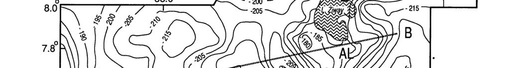
7 ALUTO-LANGANO GEOTHERMAL FIELD ELECTRICAL RESISTIVITY SURVEYS The dipole-dipole map for N=6 (Fig 6) shows a N-S low resistivity zone covering a wide area from Lake Ziway to Lake Shalla. The hot water infiltration is influenced by the local N-S ground water movement. There is a 5Ωm resistivity zone along the west Langano fault zone which serves as the main conduit for the hot fluid to flow from Aluto volcano/ziway lake area down to Lake Shalla. Schlumberger resistivity contour map for AB/2=1000m (Fig7) also shows the low resistivity anomaly areas already outlined by the dipoledipole technique around the western and southern foothills of Aluto volcano.
8
9 On Aluto volcano, the top dry post-aluto volcanic tuffs are characterized by high resistivities.. But LA-6, which was located near to alteration grounds shows relatively low resistivity top layer. The resistivity curves show similar trends and slopes signifying similar resistivity structures between AB/2=120 and 1000m. They could be the effect of porous and permeable rhyolite lava and the underlying pre-aluto basalt, which is highly altered and has a high temperature.
10 Measured temperature-depth curves of the eight drilled wells are shown in Fig 9. LA-1 and LA-2 have low recorded temperatures. These wells were drilled on the outflow zones, at the foothills of Aluto volcano. Higher temperature gradients are recorded in the wells in the Bofa basalt sequence. Higher temperatures are shown in this basalt for all wells drilled on Aluto volcano which has a thickness of 1km. LA-3 and LA-6 have stablized at temperatures 320 and 3350c respectively. In general the curves show that near the contact of the Bofa basalt and Tertiary ignimbrite temperature reversals are observed in all wells except LA-3 and LA-6 on the volcano. This is probably due to the inflow of cold water through this permeable zone.
11 The high temperature in the basalt could be because of the fact that it is fractured with hot geothermal fluids that deposited alteration minerals in the fractures and these sealed off the permeability. It seems that the basalt retained the previous high temperature because of its poor conductivity and is still getting heat laterally from upflow zones.the temperatures in LA-3 3 and LA-6 6 (Figs 11 and 12) are higher in the Tertiary ignimbrite than in the basalt, unlike the other wells on the volcano since they were drilled along an active fault zone through which hot geothermal fluid ascends to the surface.
12
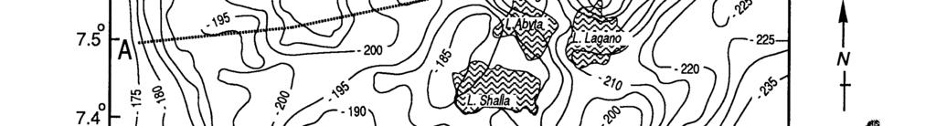
13 CORBETTI GEOTHERMAL PROSPECT The dipole-dipole map for N=5 (Fig 14) shows a low resistivity zone bounded by a 10Ωm resistivity contour between Corbetti caldera and Lake Shalla.
14 Schlumberger resistivity contours for AB/2=1470m (Fig 15) show the limit of the low resistivity zone towards Corbetti caldera indicated by the dipole-dipole results. A low resistivity zone opens from Corbetti caldera to Lake Shalla.
15 There is no thermal feature south of Corbetti Caldera. Ground water moving from Lake Awasa towards Lake Shalla heated by steam and hot water during migration through Corbetti caldera, could account for the geochemical conditions at the Chitu-Shalla springs. The results of temperature gradient holes (Fig 16) show that TG2 and TG 4 entered steam pockets for 130m (30-160m) and for 40m (40-80m) respectively. TG3 and TG6 show steam heated columns above the water table whereas TG1, 7 and 8 indicate lower conductivities near the bottom of the holes. The observations in the temperature gradient holes could not be used to site deep geothermal wells.
16 The End
An Overview of the Geology of Aluto Langano and Tendaho Geothermal Fields, Ethiopia. Solomon Kebede. Geological Survey of Ethiopia
 An Overview of the Geology of Aluto Langano and Tendaho Geothermal Fields, Ethiopia Solomon Kebede Geological Survey of Ethiopia solo450354@yahoo.com Location of Aluto Langano and Tendaho Within the Etiopian
SUB-SURFACE GEOLOGY AND HYDROTHERMAL ALTERATION OF WELLS LA-9D AND LA-10D OF ALUTO LANGANO GEOTHERMAL FIELD, ETHIOPIA
 Proceedings, 6 th African Rift Geothermal Conference Addis Ababa, Ethiopia, 2 nd -4 th November 2016 SUB-SURFACE GEOLOGY AND HYDROTHERMAL ALTERATION OF WELLS LA-9D AND LA-10D OF ALUTO LANGANO GEOTHERMAL
. Slide 1. Geological Survey of Ethiopia, P.O.Box 2302, Addis Ababa, Ethiopia
 The electrical resistivity structure of the Southern Main Ethiopian Rift (around the Lake Abaya geothermal prospect) revealed by magneto-telluric telluric imaging Mohammednur Desissa and Yohanes Lema Geological
Geothermal Exploration in Eritrea
 Geothermal Exploration in Eritrea Short Course III on Exploration for Geothermal Resources November 2008, Naivasha, Kenya Ermias Yohannes Berhane Ermias_yohannes@yahoo.com Ministry of Energy and Mines
WAMUNYU EDWARD MUREITHI I13/2358/2007
 WAMUNYU EDWARD MUREITHI I13/2358/2007 Olkaria geothermal area is situated south of Lake Naivasha on the floor of the southern segment of the Kenya rift. The geology of the Olkaria Geothermal area is subdivided
GEOTHERMAL ENERGY POTENTIAL FOR LONGONOT PROSPECT, KENYA. By Mariita N. O. Kenya Electricity Generating Company
 GEOTHERMAL ENERGY POTENTIAL FOR LONGONOT PROSPECT, KENYA By Mariita N. O. Kenya Electricity Generating Company PRESENTATION OUTLINE INTRODUCTION REGIONAL SETTING GEOLOGY GEOTHERMAL MANIFESTATIONS HYDROGEOLOGY
GEOTHERMAL POTENTIAL OF ST. KITTS AND NEVIS ISLANDS
 GEOTHERMAL POTENTIAL OF ST. KITTS AND NEVIS ISLANDS By Gerald W. Huttrer Geothermal Management Company, Inc. For the Eastern Caribbean Geothermal Energy Project ( Geo- Caraibes ; G-C ) Presented Using
Annex-2-1 The Evaluation Sheet of the Aluto Langano (Ethiopia) Geothermal Field (1)
 Geothermal Field (1)") Annex-2-1 The Evaluation Sheet of the Aluto Langano (Ethiopia) Geothermal Field (1) Location Volcanic activity Geological Structrure (Past Geological Studies included) Work done so far Gravity Resistivity
Annex-2-1 The Evaluation Sheet of the Aluto Langano (Ethiopia) Geothermal Field (1) Location Volcanic activity Geological Structrure (Past Geological Studies included) Work done so far Gravity Resistivity
Japan Engineering Consultants, Inc., Energy and Industrial Technology Development Organization,Tokyo, Japan
 DEEP GEOTHERMAL STRUCTURE AND THE HYDROTHERMAL SYSTEM THE GEOTHERMAL FIELD, JAPAN M. H. K. MATSUDA', T. K. Japan Engineering Consultants, Inc., Japan Energy and Industrial Technology Development Organization,Tokyo,
Plate Tectonics. entirely rock both and rock
 Plate Tectonics I. Tectonics A. Tectonic Forces are forces generated from within Earth causing rock to become. B. 1. The study of the origin and arrangement of Earth surface including mountain belts, continents,
INTERGRATED GEOPHYSICAL METHODS USED TO SITE HIGH PRODUCER GEOTHERMAL WELLS
 Presented at Short Course VII on Exploration for Geothermal Resources, organized by UNU-GTP, GDC and KenGen, at Lake Bogoria and Lake Naivasha, Kenya, Oct. 27 Nov. 18, 2012. GEOTHERMAL TRAINING PROGRAMME
Geothermal Exploration in Eritrea
 Geothermal Exploration in Eritrea Ermias Yohannes, Eritrea Ministry of Energy and Mines, Department of Mines ermias_yohannes@yahoo.com Short Course on Surface Exploration for Geothermal Resources UNU-GTP
Outcomes of the Workshop on the Geologic and Geothermal Development of the Western Branch of the Greater East African Rift System
 Outcomes of the Workshop on the Geologic and Geothermal Development of the Western Branch of the Greater East African Rift System East Africa Donor Coordination Meeting 14 June 2016 AUC Headquarter Addis
Structural Geology tectonics, volcanology and geothermal activity. Kristján Saemundsson ÍSOR Iceland GeoSurvey
 Structural Geology tectonics, volcanology and geothermal activity Kristján Saemundsson ÍSOR Iceland GeoSurvey Discussion will be limited to rift zone geothermal systems with sidelook on hot spot environment.
The Resistivity Structure of the Abaya Geothermal field,
 Geological Survey of Ethiopia Hydrogeology, Engineering geology and Geothermal Department The Resistivity Structure of the Abaya Geothermal field, Southern Main Ethiopian Rift, Revealed by Magneto-telluric
Part A GEOLOGY 12 CHAPTER 4 WORKSHEET VOLCANOES. Name
 GEOLOGY 12 CHAPTER 4 WORKSHEET VOLCANOES Name Part A 1. The rough, jumbled blocky or jagged surface of a lava flow is called a. pahoehoe b. lahar c. aa d. phreatic 2. The Cascade volcanoes like Mt. St.
Formation of the Hawaiian Islands. Volcanoes, Magma, and Hot Spots
 Formation of the Hawaiian Islands Volcanoes, Magma, and Hot Spots Topics Hawai i Ring of Fire Hot Spots Decompression Melting The Hawai i Hot Spot Topics Hawai i Ring of Fire Hot Spots Decompression Melting
USU 1360 TECTONICS / PROCESSES
 USU 1360 TECTONICS / PROCESSES Observe the world map and each enlargement Pacific Northwest Tibet South America Japan 03.00.a1 South Atlantic Arabian Peninsula Observe features near the Pacific Northwest
Heat (& Mass) Transfer. conceptual models of heat transfer. large scale controls on fluid movement. distribution of vapor-saturated conditions
 Transfer. conceptual models of heat transfer. large scale controls on fluid movement. distribution of vapor-saturated conditions") Heat (& Mass) Transfer conceptual models of heat transfer temperature-pressure gradients large scale controls on fluid movement distribution of vapor-saturated conditions fluid flow paths surface manifestations
Heat (& Mass) Transfer conceptual models of heat transfer temperature-pressure gradients large scale controls on fluid movement distribution of vapor-saturated conditions fluid flow paths surface manifestations
Magnetic and Gravity Methods for Geothermal Exploration
 Magnetic and Gravity Methods for Geothermal Exploration Dr. Hendra Grandis Geophysics - ITB method and survey procedure Aero- or ground magnetic (covers a large area) Schlumberger resistivity mapping and
Geochemical Monitoring of the Lakes District Area
 Proceedings World Geothermal Congress 25 Antalya, Turkey, 24-29 April 25 Geochemical Monitoring of the Lakes District Area Kibret Beyene and Meseret Teklemariam Geological Survey of Ethiopia, P.O.Box 469,
Chapter 7: Volcanoes 8/18/2014. Section 1 (Volcanoes and Plate Tectonics) 8 th Grade. Ring of Fire
 8 th Grade. Ring of Fire") Section 1 (Volcanoes and Plate Tectonics) Chapter 7: Volcanoes 8 th Grade Ring of Fire a major belt of es that rims the Pacific Ocean Volcanic belts form along the boundaries of Earth s plates as they
Section 1 (Volcanoes and Plate Tectonics) Chapter 7: Volcanoes 8 th Grade Ring of Fire a major belt of es that rims the Pacific Ocean Volcanic belts form along the boundaries of Earth s plates as they
STRUCTURAL CONTROL OF RUNGWE VOLCANIC PROVINCE AND ITS IMPLICATION ON GEOTHERMAL SYSTEM
 Proceedings, 6 th African Rift Geothermal Conference Addis Ababa, Ethiopia, 2 nd 4 th November 2016 STRUCTURAL CONTROL OF RUNGWE VOLCANIC PROVINCE AND ITS IMPLICATION ON GEOTHERMAL SYSTEM Albano Mahecha¹,
Earthquakes. Earthquakes are caused by a sudden release of energy
 Earthquakes Earthquakes are caused by a sudden release of energy The amount of energy released determines the magnitude of the earthquake Seismic waves carry the energy away from its origin Fig. 18.1 Origin
TORFAJÖKULL, ICELAND A RHYOLITE VOLCANO AND ITS GEOTHERMAL RESOURCE
 Presented at Short Course VI on Exploration for Geothermal Resources, organized by UNU-GTP, GDC and KenGen, at Lake Bogoria and Lake Naivasha, Kenya, Oct. 27 Nov. 18, 2011. GEOTHERMAL TRAINING PROGRAMME
Apr 20 2:26 PM. the opening in Earth's crust through which molten rock, gases, and ash erupt. the landform that develops around this opening
 Volcanoes Cleveland Volcano, Alaska, May 2006 Taken from the ISS Apr 20 2:26 PM The term volcano can refer to two things: 1. the opening in Earth's crust through which molten rock, gases, and ash erupt
12. The diagram below shows the collision of an oceanic plate and a continental plate.
 Review 1. Base your answer to the following question on the cross section below, which shows the boundary between two lithospheric plates. Point X is a location in the continental lithosphere. The depth
From Punchbowl to Panum: Long Valley Volcanism and the Mono-Inyo Crater Chain
 From Punchbowl to Panum: Leslie Schaffer E105 2002 Final Paper Long Valley Volcanism and the Mono-Inyo Crater Chain Figure 1. After a sequence of earthquakes during the late 1970 s to the early 1980 s
PHYSICAL GEOLOGY AND THE ENVIRONMENT (2 ND CANADIAN EDITION)
") Chapter 2: Plate Tectonics Chapter Summary: Plate tectonics is a theory that suggests Earth's surface is divided into several large plates that change position and size. Intense geologic activity occurs
Chapter 2: Plate Tectonics Chapter Summary: Plate tectonics is a theory that suggests Earth's surface is divided into several large plates that change position and size. Intense geologic activity occurs
EAST AFRICAN RIFT SYSTEM - AN OVERVIEW
 Presented at Short Course V on Exploration for Geothermal Resources, organized by UNU-GTP, GDC and KenGen, at Lake Bogoria and Lake Naivasha, Kenya, Oct. 29 Nov. 19, 2010. GEOTHERMAL TRAINING PROGRAMME
A) B) C) D) 4. Which diagram below best represents the pattern of magnetic orientation in the seafloor on the west (left) side of the ocean ridge?
 B) C) D) 4. Which diagram below best represents the pattern of magnetic orientation in the seafloor on the west (left) side of the ocean ridge?") 1. Crustal formation, which may cause the widening of an ocean, is most likely occurring at the boundary between the A) African Plate and the Eurasian Plate B) Pacific Plate and the Philippine Plate C)
1. Crustal formation, which may cause the widening of an ocean, is most likely occurring at the boundary between the A) African Plate and the Eurasian Plate B) Pacific Plate and the Philippine Plate C)
Late 20 th Century Tests of the Continental Drift Hypothesis
 Late 20 th Century Tests of the Continental Drift Hypothesis 5 Characteristics of the Ocean Trenches Unless otherwise noted the artwork and photographs in this slide show are original and by Burt Carter.
Section 10.1 The Nature of Volcanic Eruptions This section discusses volcanic eruptions, types of volcanoes, and other volcanic landforms.
 Chapter 10 Section 10.1 The Nature of Volcanic Eruptions This section discusses volcanic eruptions, types of volcanoes, and other volcanic landforms. Reading Strategy Previewing Before you read the section,
TECHNICAL REVIEW OF GEOTHERMAL POTENTIAL OF NGOZI AND SONGWE GEOTHERMAL PROSPECTS, TANZANIA.
 Proceedings, 6 th African Rift Geothermal Conference Addis Ababa, Ethiopia, 2 nd 4 th November 2016 TECHNICAL REVIEW OF GEOTHERMAL POTENTIAL OF NGOZI AND SONGWE GEOTHERMAL PROSPECTS, TANZANIA 1 Kenneth
Magma Formation and Behavior
 Magma Formation and Behavior Introduction: The study of body waves as they pass through Earth's interior provides strong evidence that the Earth's mantle is composed almost entirely of solid ultramafic
The Afar Rift Consortium
 The Afar Rift Consortium University of Bristol University of Oxford University of Cambridge British Geological Survey University of Rochester University of Auckland, NZ Opportunistic programme following
HIGH TEMPERATURE HYDROTHERMAL ALTERATION IN ACTIVE GEOTHERMAL SYSTEMS A CASE STUDY OF OLKARIA DOMES
 Proceedings, 6 th African Rift Geothermal Conference Addis Ababa, Ethiopia, 2 nd 4 th November 2016 HIGH TEMPERATURE HYDROTHERMAL ALTERATION IN ACTIVE GEOTHERMAL SYSTEMS A CASE STUDY OF OLKARIA DOMES James
Convergent plate boundaries. Objective to be able to explain the formation and key features of these zones.
 Convergent plate boundaries Objective to be able to explain the formation and key features of these zones. Destructive plate margins When plates collide due to convection currents/slab pull in the asthenosphere
Wind Mountain Project Summary Memo Feeder Program
 A Manex Resource Group Company Wind Mountain Project Summary Memo Feeder Program J.A. Kizis, Jr., February 07, 2018 Assays have been received for both holes drilled at Wind Mountain during late 2017 and
Magma. Objectives. Describe factors that affect the formation of magma. Compare and contrast the different types of magma. Vocabulary.
 Magma Objectives Describe factors that affect the formation of magma. Compare and contrast the different types of magma. Vocabulary viscosity Magma Magma The ash that spews from some volcanoes can form
Directed Reading. Section: Volcanoes and Plate Tectonics
 Skills Worksheet Directed Reading Section: Volcanoes and Plate Tectonics 1. What can cause some of the most dramatic changes to Earth s surface? a. solar activity b. tides c. geysers d. volcanic eruptions
Chapter 18 - Volcanic Activity. Aka Volcano Under the City
 Chapter 18 - Volcanic Activity Aka Volcano Under the City 18.1 Magma Describe factors that affect the formation of magma. Compare and contrast the different types of magma. Temperature and pressure increase
NOTICE CONCERNING COPYRIGHT RESTRICTIONS
 NOTICE CONCERNING COPYRIGHT RESTRICTIONS This document may contain copyrighted materials. These materials have been made available for use in research, teaching, and private study, but may not be used
Magma. Objectives. Describe factors that affect the formation of magma. Compare and contrast the different types of magma. Vocabulary.
 Magma Objectives Describe factors that affect the formation of magma. Compare and contrast the different types of magma. Vocabulary viscosity Magma Magma The ash that spews from some volcanoes can form
Directed Reading. Section: The Theory of Plate Tectonics. to the development of plate tectonics, developed? HOW CONTINENTS MOVE
 Skills Worksheet Directed Reading Section: The Theory of Plate Tectonics 1. The theory that explains why and how continents move is called. 2. By what time period was evidence supporting continental drift,
Chapter 10: Volcanoes and Other Igneous Activity Section 1: The Nature of Volcanic Eruptions I. Factors Affecting Eruptions Group # Main Idea:
 Chapter 10: Volcanoes and Other Igneous Activity Section 1: The Nature of Volcanic Eruptions I. Factors Affecting Eruptions Group # A. Viscosity Group # B. Dissolved Gases Group # II. Volcanic Material
Practice Questions: Plate Tectonics
 Practice Questions: Plate Tectonics 1. Base your answer to the following question on The block diagram below shows the boundary between two tectonic plates. Which type of plate boundary is shown? A) divergent
Earth and Space Science Semester 2 Exam Review. Part 1. - Convection currents circulate in the Asthenosphere located in the Upper Mantle.
 Earth and Space Science 2015 Semester 2 Exam Review Part 1 Convection -A form of heat transfer. - Convection currents circulate in the Asthenosphere located in the Upper Mantle. - Source of heat is from
Study guide chapter 9
 Study guide chapter 9 1. What are the three ways solid mantle material can change phase to a liquid? Associate a boundary/hot spot to each way mantle material changes phase. 1. A decrease in pressure which
Calc-alkaline Volcanic Rocks. Calc-alkali Volcanics. Fabric. Petrography. Compositional Classification. Petrography. Processes.
 Calc-alkaline Volcanic Rocks Calc-alkali Volcanics Winter Chapters 16 & 17 Petrography Processes Field relations Volcanic arcs Petrogenesis Petrography Fabric Classification Alteration Fabric Aphanitic
GEOLOGY MEDIA SUITE Chapter 12
 UNDERSTANDING EARTH, SIXTH EDITION GROTZINGER JORDAN GEOLOGY MEDIA SUITE Chapter 12 Volcanoes 2010 W.H. Freeman and Company Plate tectonics explains the global pattern of volcanism. Key Figure 12.20 (page
Most mafic magmas come from the upper mantle and lower crust. This handout will address five questions:
 Geology 101 Origin of Magma From our discussions of the structure of the interior of the Earth, it is clear that the upper parts of the Earth (crust and mantle) are mostly solid because s-waves penetrate
A Volcano is An opening in Earth s crust through
 Volcanoes A Volcano is An opening in Earth s crust through which molten rock, gases, and ash erupt. Also, the landform that develops around this opening. Kinds of Eruptions Geologists classify volcanic
Magmatism in Western Cascades Arc. Early Tertiary Magmatism Part II. Washington Magmatism. Western Oregon. Southern Oregon
 Early Tertiary Magmatism Part II Reference: DNAG v. 3, Ch. 7, pp 294-314 Magmatism in Western Cascades Arc Active from 38 to 17 Ma New volcanic activity west of Clarno Fm and south into Oregon Western
Outcomes of the Workshop on the Geologic and Geothermal Development of the Western Branch of the Greater East African Rift System
 Outcomes of the Workshop on the Geologic and Geothermal Development of the Western Branch of the Greater East African Rift System Energy Ministerial Meeting 13 June 2016 AUC Headquarter Addis Ababa, Ethiopia
Plate Tectonics Lab II: Background Information
 Plate Tectonics Lab II: Background Information This lab is based on a UW ESS101 Lab. Note: Hand in only the Answer Sheet at the back of this guide to your Instructor Introduction One of the more fundamental
Marine Science and Oceanography
 Marine Science and Oceanography Marine geology- study of the ocean floor Physical oceanography- study of waves, currents, and tides Marine biology study of nature and distribution of marine organisms Chemical
amenable to economic extraction, is called geothermal energy. This energy is a potentially important and promising alternative energy source ABSTRACT
 PROCEEDINGS, Twenty-Fifth Workshop on Geothermal Reservoir Engineering Stanford University, Stanford, California, January 24-26, 2000 SGP-TR-165 GEOPHYSICAL, GEOLOGICAL AND HYDROGEOLOGICAL INVESTIGATIONS
Prentice Hall EARTH SCIENCE
 Prentice Hall EARTH SCIENCE Tarbuck Lutgens Chapter 10 Volcanoes and Other Igneous Activity 10.1 The Nature of Volcanic Eruptions Factors Affecting Eruptions Factors that determine the violence of an eruption
Prentice Hall EARTH SCIENCE
 Prentice Hall EARTH SCIENCE Tarbuck Lutgens Chapter 9 Plate Tectonics 9.1 Continental Drift An Idea Before Its Time Wegener s continental drift hypothesis stated that the continents had once been joined
Prentice Hall EARTH SCIENCE
 Prentice Hall EARTH SCIENCE Tarbuck Lutgens Chapter 9 Plate Tectonics 9.1 Continental Drift An Idea Before Its Time Wegener s continental drift hypothesis stated that the continents had once been joined
Chapter 2 Plate Tectonics and the Ocean Floor
 Chapter 2 Plate Tectonics and the Ocean Floor Matching. Match the term or person with the appropriate phrase. You may use each answer once, more than once or not at all. 1. hydrothermal vents A. convergent
Conceptual model for non-volcanic geothermal resources - examples from Tohoku Japan
 Conceptual model for non-volcanic geothermal resources - examples from Tohoku Japan S. Tamanyu 1 and K. Sakaguchi 2 1, 2 Geological Survey of Japan, National Institute of Advanced Industrial Science and
Visualizing Earth Science. Chapter Overview. Volcanoes and Eruption Types. By Z. Merali and B. F. Skinner. Chapter 9 Volcanism and Other
 Visualizing Earth Science By Z. Merali and B. F. Skinner Chapter 9 Volcanism and Other Igneous Processes Volcanoes types and effects of eruption Chapter Overview Melting and cooling of rocks Geological
Characterization of Quaternary Extensional Structures: Tulu-Moye Geothermal Prospect, Ethiopia
 GRC Transactions, Vol. 39, 2015 Characterization of Quaternary Extensional Structures: Tulu-Moye Geothermal Prospect, Ethiopia Engdawork Admassu 1 and Selamawit Worku 2 1 Geological Survey of Ethiopia,
Figure 1: Location of principal shallow conductors at Alpala (anomalies C0-C10; 5 Ohm/m surfaces, red) and shallow zones of electrical chargeability
 and shallow zones of electrical chargeability") Figure 1: Location of principal shallow conductors at Alpala (anomalies C0-C10; 5 Ohm/m surfaces, red) and shallow zones of electrical chargeability (85 msecs, yellow-green) shown on iso-surfaces of MVI
Figure 1: Location of principal shallow conductors at Alpala (anomalies C0-C10; 5 Ohm/m surfaces, red) and shallow zones of electrical chargeability (85 msecs, yellow-green) shown on iso-surfaces of MVI
Section 2: How Mountains Form
 Section 2: How Mountains Form Preview Objectives Mountain Ranges and Systems Plate Tectonics and Mountains Types of Mountains Objectives Identify the types of plate collisions that form mountains. Identify
Before Plate Tectonics: Theory of Continental Drift
 Before Plate Tectonics: Theory of Continental Drift Predecessor to modern plate tectonics Shape and fit of the continents was the initial evidence Snider-Pelligrini (1858) Taylor (1908) Wegner (1915) Fig.
Using 3D/4D modeling tools in exploration of gold-polymetallic potential areas in Greece
 Using 3D/4D modeling tools in exploration of gold-polymetallic potential areas in Greece Arvanitidis N.D., Michael C., Weihed P., Gaál l G., Royer J.J., Perantonis G., Bakalis V., Ballas D. and Christidis
Geo-scientific Data Integration to Evaluate Geothermal Potential Using GIS (A Case for Korosi-Chepchuk Geothermal Prospects, Kenya)
") Geo-scientific Data Integration to Evaluate Geothermal Potential Using GIS (A Case for Korosi-Chepchuk Geothermal Prospects, Kenya) Levi Shako and Joseph Mutua Geothermal Development Company, P. O. Box
Geo-scientific Data Integration to Evaluate Geothermal Potential Using GIS (A Case for Korosi-Chepchuk Geothermal Prospects, Kenya) Levi Shako and Joseph Mutua Geothermal Development Company, P. O. Box
Volcano-tectonic and hydrothermal activity in the Soddo area, western margin of the Southern Main Ethiopian Rift
 Proceedings 5 th African Rift geothermal Conference Arusha, Tanzania, 29-31 October 2014 Volcano-tectonic and hydrothermal activity in the Soddo area, western margin of the Southern Main Ethiopian Rift
CERD STATE OF KNOWLEDGE OF THE GEOTHERMAL PROVINCES OF REPUBLIC OF DJIBOUTI. ARGEO-C1 Conference Addis-Ababa, Ethiopia, November 2006
 STATE OF KNOWLEDGE OF THE GEOTHERMAL PROVINCES OF REPUBLIC OF DJIBOUTI ARGEO-C1 Conference Addis-Ababa, Ethiopia, 24-29 November 2006 JALLUDIN Mohamed Djibouti, GEOTHERMAL EXPLORATIONS IN DJIBOUTI FIRST
The Nature of Igneous Rocks
 The Nature of Igneous Rocks Form from Magma Hot, partially molten mixture of solid liquid and gas Mineral crystals form in the magma making a crystal slush Gases - H 2 O, CO 2, etc. - are dissolved in
Directed Reading. Section: Volcanoes and Plate Tectonics
 Skills Worksheet Directed Reading Section: Volcanoes and Plate Tectonics 1. Some volcanic eruptions can be more powerful than a(n) a. hand grenade. b. earthquake. c. geyser. d. atomic bomb. 2. The cause
What Forces Drive Plate Tectonics?
 What Forces Drive Plate Tectonics? The tectonic plates are moving, but with varying rates and directions. What hypotheses have been proposed to explain the plate motion? Convection Cells in the Mantle
Most mafic magmas come from the upper mantle and lower crust. This handout will address five questions:
 IDS 102 Origin of Magma From our discussions of the structure of the interior of the Earth, it is clear that the upper parts of the Earth (crust and mantle) are mostly solid because s-waves penetrate those
The Quaternary and Pliocene Yellowstone Plateau Volcanic Field of Wyoming, Idaho and Montana Robert L. Christenson, USGS PP 729-G
 The Quaternary and Pliocene Yellowstone Plateau Volcanic Field of Wyoming, Idaho and Montana Robert L. Christenson, USGS PP 729-G Three Volcanic Cycles of Yellowstone Three extraordinarily large explosive
GEOTHERMAL DEVELOPMENT IN THE COMOROS AND RESULTS OF GEOTHERMAL SURFACE EXPLORATION
 Proceedings, 6 th African Rift Geothermal Conference Addis Ababa, Ethiopia, 2 nd 4 th November 2016 GEOTHERMAL DEVELOPMENT IN THE COMOROS AND RESULTS OF GEOTHERMAL SURFACE EXPLORATION Mohamed Chaheire,
Overview of Ch. 4. I. The nature of volcanic eruptions 9/19/2011. Volcanoes and Other Igneous Activity Chapter 4 or 5
 Overview of Ch. 4 Volcanoes and Other Igneous Activity Chapter 4 or 5 I. Nature of Volcanic Eruptions II. Materials Extruded from a Volcano III.Types of Volcanoes IV.Volcanic Landforms V. Plutonic (intrusive)
Integrated Geophysical Model for Suswa Geothermal Prospect using Resistivity, Seismics and Gravity Survey Data in Kenya
 Proceedings World Geothermal Congress 2015 Melbourne, Australia, 19-25 April 2015 Integrated Geophysical Model for Suswa Geothermal Prospect using Resistivity, Seismics and Gravity Survey Data in Kenya
TAKE HOME EXAM 8R - Geology
 Name Period Date TAKE HOME EXAM 8R - Geology PART 1 - Multiple Choice 1. A volcanic cone made up of alternating layers of lava and rock particles is a cone. a. cinder b. lava c. shield d. composite 2.
Plate Tectonics. Structure of the Earth
 Plate Tectonics Structure of the Earth The Earth can be considered as being made up of a series of concentric spheres, each made up of materials that differ in terms of composition and mechanical properties.
Annað veldi ehf. Geothermal Provinces of Kenya
 Annað veldi ehf Geothermal Provinces of Kenya David Köndgen and Skuli Johannsson September 29, 2009 OUTLINE Overview Geology of Kenya Excursus: The Wilson Cycle How do rifts form? The world of Platetectonics
Chapter 02 The Sea Floor
 Chapter 02 The Sea Floor Multiple Choice Questions 1. One of the following is not one of the world's major ocean basins: A. Atlantic Ocean B. Arctic Ocean C. Indian Ocean D. Antarctic Ocean E. Pacific
Three-dimensional geophysical modelling of the Alalobeda geothermal field
 Three-dimensional geophysical modelling of the Alalobeda geothermal field Daniele Rizzello 1, Egidio Armadillo 2, Claudio Pasqua 2,3, Massimo Verdoya 2, Solomon Kebede 4, Andarge Mengiste 4, Getenesh H/Giorgis
THE ZUNIL-II GEOTHERMAL FIELD, GUATEMALA, CENTRAL AMERICA
 THE ZUNIL-II GEOTHERMAL FIELD, GUATEMALA, CENTRAL AMERICA Enrique M. Lima Lobato 1 and Julio Palma 2 1 West Japan Engineering Consultants, Inc., 1-82, 2-Chome, Watanabe-dori, Chuo-ku, Fukuoka 810-0004,
Magma Formation and Behavior
 Magma Formation and Behavior Questions What causes mantle rock to melt, resulting in magma formation? Why is magma formation restricted to specific plate tectonic settings? Why are mafic (basaltic) magmas
Introduction to Earth s s Spheres The Benchmark
 Introduction to Earth s s Spheres The Benchmark Volcanism Volcanic eruptions Effusive: lavas (e.g., Kilauea) Volcanism Volcanic eruptions Explosive: pyroclastic rocks (e.g., Krakatau) Factors Governing
Copyright McGraw-Hill Education. All rights reserved. No reproduction or distribution without the prior written consent of McGraw-Hill Education
 Copyright McGraw-Hill Education. All rights reserved. No reproduction or distribution without the prior written consent of McGraw-Hill Education Tibetan Plateau and Himalaya -southern Asia 11.00.a VE 10X
Unit 4 Lesson 4 Volcanoes. Copyright Houghton Mifflin Harcourt Publishing Company
 Magma Magic What is a volcano? A volcano is any place where gas, ash, or melted rock come out of the ground. Many volcanoes are dormant, meaning an eruption has not occurred in a long period of time. What
Questions and Topics
 Plate Tectonics and Continental Drift Questions and Topics 1. What are the theories of Plate Tectonics and Continental Drift? 2. What is the evidence that Continents move? 3. What are the forces that
Plate Tectonics: The New Paradigm
 Earth s major plates Plate Tectonics: The New Paradigm Associated with Earth's strong, rigid outer layer: Known as the lithosphere Consists of uppermost mantle and overlying crust Overlies a weaker region
Along the center of the mid-ocean ridge is a rift valley that forms when the plates separate.
 Newly formed rock from rising magma rises above sea floor and forms mountain ranges known as midocean ridges. Along the center of the mid-ocean ridge is a rift valley that forms when the plates separate.
1. The process by which the ocean floor sinks beneath a deep-ocean trench and back into the mantle is known as
 Sample questions 1. The process by which the ocean floor sinks beneath a deep-ocean trench and back into the mantle is known as b. continental drift c. subduction d. conduction 2. The transfer of thermal
UGRC 144 Science and Technology in Our Lives/Geohazards
 UGRC 144 Science and Technology in Our Lives/Geohazards Session 5 Magma and Volcanism Lecturer: Dr. Patrick Asamoah Sakyi Department of Earth Science, UG Contact Information: pasakyi@ug.edu.gh College
Wilson cycle. 1. Intracontinental rift 2. From rifting to drifting
 Wilson cycle 1. Intracontinental rift 2. From rifting to drifting Stages of the Wilson Cycle Intracontinental Rifts 1. Contemporary examples (EAR, RGR, Baikal, Rhine graben) 2. Mechanical aspects. Characteristics
SPECTRAL ANALYSIS OF GROUND MAGNETIC DATA IN MAGADI AREA, SOUTHERN KENYA RIFT
 SPECTRAL ANALYSIS OF GROUND MAGNETIC DATA IN MAGADI AREA, SOUTHERN KENYA RIFT 1 JG Githiri, 2 JP Patel, 3 JO Barongo and 4 PK Karanja 1 Jomo-Kenyatta University of Agriculture, Science and Technology,
MULTIPLE CHOICE. Choose the one alternative that best completes the statement or answers the question.
 Geology 300, Physical Geology Spring 2019 Quiz Chapter 18, Seafloor Name MULTIPLE CHOICE. Choose the one alternative that best completes the statement or answers the question. 1) Abyssal fans are made
Volcanic Landforms, Volcanoes and Plate Tectonics
 Page 1 of 12 EENS 3050 Tulane University Natural Disasters Prof. Stephen A. Nelson Volcanic Landforms, Volcanoes and Plate Tectonics This page last updated on 26-Aug-2017 Volcanic Landforms Volcanic landforms
ANOTHER MEXICAN EARTHQUAKE! Magnitude 7.1, Tuesday Sept. 19, 2017
 ANOTHER MEXICAN EARTHQUAKE! Magnitude 7.1, Tuesday Sept. 19, 2017 Why is there no oceanic crust older than 200 million years? SUBDUCTION If new oceanic crust is being continuously created along the earth