Introduction to the use of gravity measurements in Ge111A
|
|
|
- Archibald Matthews
- 6 years ago
- Views:
Transcription
1 Introduction to the use of gravity measurements in Ge111A Background & basic intuition Data reduction Use of the instrument See Reynolds for detailed quantitative discussion
2 What and Why Gravity measures the distribution of mass Variations in density Variations in interface locations Very non-unique => use in conjunction with other constraints (geologic, seismic, ) Targets include: Topographic compensation - the crustal root (long λ) Fault structures/offsets (best for dip-slip faults or large offset strike-slip) Aquifers Tunnels Buried objects (tunnels, ore deposits, ) Basin sediment fill depth (together with magnetic field variations)
3 Data Availability Regional: Carry the gravimeter around Land, boat, plane Arbitrary resolution Global: Satellite tracking/altimetry (over water)/other ~2 km resolution over oceans ~100 km resolution from harmonic models None of these useful for our purposes
4 Basic intuition Everything we need can be worked out from basic potential field theory (see Reynolds or Turcotte & Schubert): 2 A = where A is the gravitational potential 0 g z A = z where g z is the vertical component of the gravity field Units: 1 mgal = 10-5 m/s 2 1 Gal = 1 cm/s 2 (named after Galileo) 1 g.u. = 0.1 mgal = 10-6 m/s 2
5 Attraction from harmonic distribution of mass I Z ρh k cos( kx)= σ k cos( kx) Why? Intuition Decompose any mass distribution into individual harmonic (Fourier) contributions and sum linearly Example: Topography, density variations on a 2D or 3D grid X
6 Attraction from harmonic distribution of mass II We won t derive solutions today, but you can imagine integrating over our given harmonic mass distribution. The vertical component is: where k = 2π/λ, h<<λ δg = Gδm ˆ r r 2 g z = 2πG ρh k cos( kx)e kz = 2πG σ k cos( kx)e kz The e -kz term corresponds to the 1/r 2 decay with distance (the peaks and troughs tend to cancel when viewed from increasingly large distances) Z ρh k cos( kx)= σ k cos( kx) X
7 Attraction from harmonic distribution of mass III At long λ, k 0 g z = 2πG ρh = 2πG σ No z-dependence Attraction from an infinite sheet of mass Will be used in making the Bouguer correction For z 0 If z increases (or k increases λ decreases): e -kz 0 Upward continuation: e.g., Z=λ, e -2π =0.002 (faint signals) Downward continuation: e.g., Z=-λ, e 2π =500 (amplification of short λ noise)
8 Standard gravity corrections earth tide correction, which corrects for tidal effects of moon & sun instrument drift correction to compensate for drift in the instrument's spring; the latitude correction, which incorporates the variation of the Earth's gravity with latitude; the free-air correction, which accounts for the variation in gravity due to elevation relative to sea level; the Bouguer correction, which corrects for the attraction of material between the station and sea level; the curvature correction, which corrects the Bouguer correction for the effect of the Earth's curvature; the terrain correction, which removes the effect of topography to a radial distance of km; the isostatic correction, which removes long-wavelength variations in the gravity field inversely related to topography. The Eötvös correction for a moving platform
9 Free Air Correction Bring all observations to a common horizontal reference surface (E.g., a datum or geoid) Effect of distance not mass Results in Free Air Gravity Commonly used for airborne and marine data g 0 = Gm R 2 ; g h = Gm (R+ h) 2 δg FA h = g h g 0 h 2g 0 = mgals/m R The L&R gravimeter has a sensitivity of ~3µGal h = δg FAR 1cm 2g 0 Careful with surveying (know your target)
10 Bouguer Correction Effect of mass (not distance) - Assume λ>>h, ignores dh/dx + g B = 2πG ρh ρ h h x What density to use? Standard is 2670 kg/m 3 You can also use this to estimate density Nettleton s Approach - assume all variations are due to topography Clever differencing of gravity profiles is sometimes useful More sophisticated approaches Terrain corrections (graphical) Talwani (2D and 2.5D prisms - Matlab) Parker s Method (finite amplitude harmonic summation) Common Shapes (see textbook)
11 The LaCoste & Romberg Model G Gravimeter Read Reynolds p for how this works. Needs power to keep isothermal - keep plugged in somewhere Highly sensitive spring and mass system (read Reynolds) - Do not move it without clamping the mass Getting data Level gravimeter (you want all of g z ) Unclamp Get a reading by adjusting the spring s.t. mass is in the right place - can be tedious if you have changed location a lot A manual raw data point is also derived by reading off the counts and converting to mgals using a calibrated table (or Matlab) Typically, take a manual reading at a base station, then lock the beam and use the feedback system to record values relative to the base station reading Reclamp Return to base station every hour for tide/drift correction.
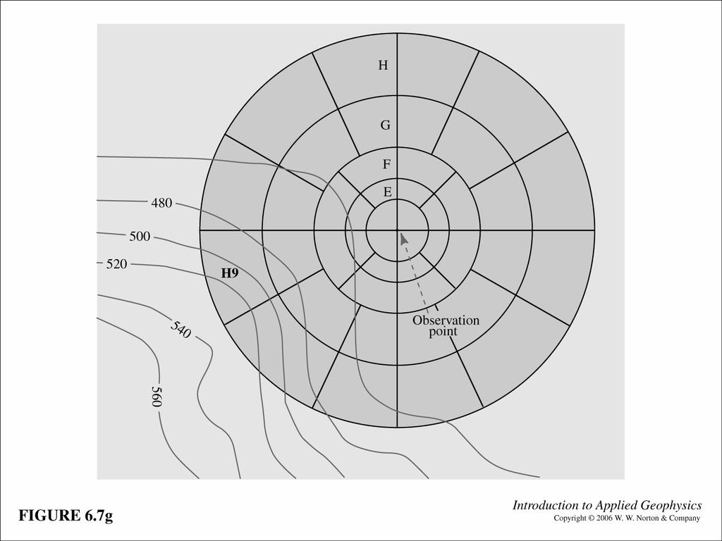
12 The next 3 figures relate to the problem of a terrain correction. The circular chart (hammer chart) is used to assess the effect of mass at different distances from the measurement point. See Reynolds p for more details.
13
14
15
 p.")
16 Isostatic residual gravity map (Langenheim & Jachens, 2002, BSSA v. 92(4) p ).

17 Magnetic anomaly map (Langenheim & Jachens 2002)
18 Remember from last week: magnetic anomaly strength goes as 1/r 3 ; gravity anomaly goes as 1/r 2. Magnetic potential goes as 1/r 2 ; gravitational potential goes as 1/r. Therefore the magnetic potential and the gravity anomaly have similar form (if they arise from an object of uniform density & magnetization). See figure to the left showing that the magnetic anomaly looks like the derivative of the gravity anomaly. If you integrate the magnetic anomaly you can make a pseudogravity anomaly which can help with your 3-E structural interpretation. Read about this and see Fig. 6 in the Langenheim & Jachens paper. Figures at left from Langenheim & Jachens 2002
19 Homework 1. The measurements listed at right were made sequentially in the Caltech library building during the course of one hour. Base is outside the door at ground level. What is distance between each floor? How high is the library? Show your work. Explain what assumptions you are making. Millikan library, Caltech Floor Gravity (mgal) Base Third Sixth Ninth Roof Base Look up the coordinates (lat-long-elevation) of Caltech and Bombay Beach, on the E side of the Salton Sea. How will the gravity change between Caltech and our field area? Again, show your work.
Introduction to the use of gravity measurements
 Introduction to the use of gravity measurements Background & basic intuition Data reduction Use of the instrument See Reynolds, Chpt 2, for detailed quantitative discussion What and Why Gravity measures
r 1 r 2 r 3 Dr is what matters!
 Today s Agenda Gravity - Background & basic intuition - Data reduction - Use of the instrument - See textbook for detailed quantitative discussion - Measure height of Millikan or S. Mudd What and Why Gravity
Gravity data reduction
 Gravity data reduction REDUCTION: raw data à gravity anomaly data Temporal corrections tides and instrument drift Spatial corrections latitude and elevation GRS67 = gravity variation with latitude at sea
GRAVITY EXPLORATION (Gph 301) Chokri Jallouli 2014/2015
 Chokri Jallouli 2014/2015") KING SAUD UNIVERSITY FACULTY OF SCIENCES Department of Geology and Geophysics GRAVITY EXPLORATION (Gph 301) Chokri Jallouli 2014/2015 INTRODUCTION Definition Gravity method consists of measuring, studying
KING SAUD UNIVERSITY FACULTY OF SCIENCES Department of Geology and Geophysics GRAVITY EXPLORATION (Gph 301) Chokri Jallouli 2014/2015 INTRODUCTION Definition Gravity method consists of measuring, studying
2.2 Gravity surveys. Gravity survey
 2.2 Gravity surveys Gravity survey The effect of latitude The effect of elevation The Bouguer effect Topographic effect The effect of tides Summary of corrections Gravity in boreholes Gravity survey In
Lab 8: Gravity and Isostasy (35 points)
") it's not the most important thing in your life right now. But what is important is gravity. Arnold Schwarzenegger as Colonel John Matrix, Commando (Check out this classic of American cinema!) Lab 8: Gravity
it's not the most important thing in your life right now. But what is important is gravity. Arnold Schwarzenegger as Colonel John Matrix, Commando (Check out this classic of American cinema!) Lab 8: Gravity
Total gravitational field is sum of contributions from all masses.
 Gravity force (acceleration) vs potential (energy) acceleration (g) => GM/r 2 Potential => - GM/r G is Newton s gravitational constant 6.67x10⁻¹¹ (S.I. units) you should determine what the S.I. units are
 http://foundation.aapg.org/students/undergraduate/weeks.cfm Tim Carr - West Virginia University 3 Potential Fields Indirect Visualization Density and Magnetization Gravity and Magnetic Exploration Locate
mdu G = Fdr = mgdr Dr. Clint Conrad POST 804 Gravity, the Geoid, and Mantle Dynamics Lecture: Gravity and the Geoid U G = G M r
 GG 611 Big Gulp Fall 2014 Gravity, the Geoid, and Mantle Dynamics Lecture: Gravity and the Geoid Dr. Clint Conrad POST 804 clintc@hawaii.edu Gravitational Potential For a point mass: Newton s law of gravitation:
Note that gravity exploration is different to seismic exploration in the following way:
 224B3 Other factors that cause changes in g and need to be corrected Note that gravity exploration is different to seismic exploration in the following way: In a seismic survey, the travel time depends
Determination of Subsurface Bulk Density Distribution for Geotechnical Investigation using Gravity Technique
 Journal of Earth Sciences and Geotechnical Engineering, vol. 7, no.2, 2017, 63-69 ISSN: 1792-9040 (print), 1792-9660 (online) Scienpress Ltd, 2017 Determination of Subsurface Bulk Density Distribution
Last week we obtained a general solution: 1 cos αdv
 GRAVITY II Surface Gravity Anomalies Due to Buried Bodies Simple analytical solution may be derived for bodies with uniform density contrast simple shape, such as: Sphere Horizontal/vertical cylinders
SURVEI GRAVITI (Gravity Surveying)
") Introduction SURVEI GRAVITI (Gravity Surveying) Gravity surveys measure the acceleration due to gravity, g. Average value of g at Earth s surface is 9.80 ms -2. Gravitational attraction depends on density
Introduction SURVEI GRAVITI (Gravity Surveying) Gravity surveys measure the acceleration due to gravity, g. Average value of g at Earth s surface is 9.80 ms -2. Gravitational attraction depends on density
Getting Started: Using and Understanding Gravity Data
 The University of Texas at El Paso Pan-American Center for Earth and Environmental Studies Thu 13-Sep-2007 ABOUT PACES Mission Newsletter Sponsors RESEARCH Geoinformatics Remote Sensing Geoscience GIS
Gravity Methods (IV)
") Environmental and Exploration Geophysics II Gravity Methods (IV) tom.h.wilson tom.wilson@mail.wvu.edu Department of Geology and Geography West Virginia University Morgantown, WV Possible employment opportunities
Environmental and Exploration Geophysics II Gravity Methods (IV) tom.h.wilson tom.wilson@mail.wvu.edu Department of Geology and Geography West Virginia University Morgantown, WV Possible employment opportunities
OUTLINE. Many of us secretly dream of six months without gravity COURSE DESCRIPTION
 GEOL 481.3 OUTLINE POTENTIAL FIELD METHODS GEOL 481.3 email: jim.merriam@usask.ca POTENTIAL FIELD METHODS Many of us secretly dream of six months without gravity Allan Fotheringham COURSE DESCRIPTION This
Section 2: Gravity Surveying
 Introduction Section 2: Gravity Surveying Gravity surveys measure the acceleration due to gravity, g. Average value of g at Earth s surface is 9.80 ms -2. Gravitational attraction depends on density of
Magnetic and Gravity Methods for Geothermal Exploration
 Magnetic and Gravity Methods for Geothermal Exploration Dr. Hendra Grandis Geophysics - ITB method and survey procedure Aero- or ground magnetic (covers a large area) Schlumberger resistivity mapping and
GRAVITY EXPLORATION. subsurface density. (material property) Gravity anomalies of some simple shapes
 Gravity anomalies of some simple shapes") GRAVITY EXPLORATION g at surface (observation) subsurface density (material property) subsurface geology Gravity anomalies of some simple shapes Reminder: we are working with values about... 0.01-0.001
GRAVITY EXPLORATION g at surface (observation) subsurface density (material property) subsurface geology Gravity anomalies of some simple shapes Reminder: we are working with values about... 0.01-0.001
Isostacy: Compensation of Topography and Isostatic Geoid Anomalies
 Isostacy: Compensation of Topography and Isostatic Geoid Anomalies November 3, 2016 1 Isostacy One of the major goals of interpreting planetary gravity fields is to understand how topography positive (
HIMALAYAN AIRBORNE GRAVITY AND GEOID OF NEPAL
 Mt. Everest HIMALAYAN AIRBORNE GRAVITY AND GEOID OF NEPAL -Niraj Manandhar Head, Geodetic Survey Branch Survey Department, Geodetic Survey Branch Project Background Air Borne Gravity Survey Project was
Environmental and Exploration Geophysics I Gravity I tom.h.wilson
 Environmental and Exploration Geophysics I Gravity I tom.h.wilson tom.wilson@mail.wvu.edu Department of Geology and Geography West Virginia University Morgantown, WV Discuss mid term exam Objectives for
CHAPTER X. Second Half Review 2017
 CHAPTER X Second Half Review 217 Here is a quick overview of what we covered in the second half of the class. Remember that the final covers the whole course but there will naturally be a bias towards
Gravitational constraints
 Gravitational constraints Reading: Fowler p172 187 Gravity anomalies Free-air anomaly: g F = g g( λ ) + δg obs F Corrected for expected variations due to the spheroid elevation above the spheroid Bouguer
GRAVITY AND MAGNETIC SURVEY NECHAKO BASIN STUDY ACQUISITION AND PROCESSING PHASE
 GRAVITY AND MAGNETIC SURVEY NECHAKO BASIN STUDY ACQUISITION AND PROCESSING PHASE Report prepared for the B.C. Ministry of Energy and Mines Resource Development Division New Ventures Branch by Bemex Consulting
TERRAIN (BOUGUER) DENSITY. One of the largest effects on gravity is the attraction of the topography near the
 DENSITY. One of the largest effects on gravity is the attraction of the topography near the") TERRAIN (BOUGUER) DENSITY One of the largest effects on gravity is the attraction of the topography near the gravity station. This is distinct from the Bouguer correction, which corrects for the attraction
TERRAIN (BOUGUER) DENSITY One of the largest effects on gravity is the attraction of the topography near the gravity station. This is distinct from the Bouguer correction, which corrects for the attraction
GRAVITY AND MAGNETIC METHODS
 Presented at Short Course IX on Exploration for Geothermal Resources, organized by UNU-GTP, GDC and KenGen, at Lake Bogoria and Lake Naivasha, Kenya, Nov. 2-24, 2014. Kenya Electricity Generating Co.,
HOMEWORK 3 Draft presentations due November 4 Oral presentations of Group problems, November 6, November 8
 HOMEWORK 3 Draft presentations due November 4 Oral presentations of Group problems, November 6, November 8 Group A1 Modeling marine magnetic anomalies Write a Matlab program to generate marine magnetic
INTRODUCTION TO APPLIED GEOPHYSICS
 INTRODUCTION TO APPLIED GEOPHYSICS EXPLORING THE SHALL0W SUBSURFACE H. Robert Burger Anne F. Sheehan Craig H.Jones VERSITY OF COLORADO VERSITY OF COLORADO W. W. NORTON & COMPANY NEW YORK LONDON Contents
(b) What is the amplitude at the altitude of a satellite of 400 km?
 What is the amplitude at the altitude of a satellite of 400 km?") Practice final quiz 2015 Geodynamics 2015 1 a) Complete the following table. parameter symbol units temperature T C or K thermal conductivity heat capacity density coefficient of thermal expansion volumetric)
Practice final quiz 2015 Geodynamics 2015 1 a) Complete the following table. parameter symbol units temperature T C or K thermal conductivity heat capacity density coefficient of thermal expansion volumetric)
3. Magnetic Methods / 62
 Contents Preface to the Second Edition / xv Excerpts from Preface to the FirstEdition / xvii Mathematical Conventions / xix 1. Introduction / 1 Reference / 5 2. Gravity Methods / 6 2. I. Introduction /
Last Time. Today s s Agenda. Geophysics. Geophysics. Geophysics. MAS 603: Geological Oceanography. Lecture 21: Geophysics 1: Gravity
 UNIVERSITY OF SOUTH ALABAMA Last Time MAS 603: Geological Oceanography Extinctions Lecture 21: 1: http://www.cartoonstock.com/newscartoons/cartoonists/for/lowres/forn441l.jpg Today s s Agenda Introduction
PART A: Short-answer questions (50%; each worth 2%)
") PART A: Short-answer questions (50%; each worth 2%) Your answers should be brief (just a few words) and may be written on these pages if you wish. Remember to hand these pages in with your other exam pages!
PART A: Short-answer questions (50%; each worth 2%) Your answers should be brief (just a few words) and may be written on these pages if you wish. Remember to hand these pages in with your other exam pages!
9. Density Structure. The Australian Continent: A Geophysical Synthesis Density Structure
 84 The Australian Continent: A Geophysical Synthesis Density Structure 9. Density Structure Although the primary focus for the development of the AuSREM model was the creation of 3-D seismic wavespeed
Tidal Effects on Earth s Surface
 Tidal Effects on Earth s Surface Tom Murphy February, 1 This treatment follows the conventions of F. D. Stacey s Physics of the Earth, and is largely an elaboration on this work. 1 Tidal Potential The
Iterative 3D gravity inversion with integration of seismologic data
 BOLLETTINO DI GEOFISICA TEORICA ED APPLICATA VOL. 40, N. 3-4, pp. 469-475; SEP.-DEC. 1999 Iterative 3D gravity inversion with integration of seismologic data C. BRAITENBERG and M. ZADRO Department of Earth
Geothermal Energy Resources Exploration using Gravity and magnetics. By Mariita, N.O. KenGen
 Geothermal Energy Resources Exploration using Gravity and magnetics By Mariita, N.O. KenGen What is Geothermal Energy? Geothermal Energy = heat from the Earth Transmitted by fluids via fractures and pores
GRAVIMETRIC MAP OF CHILE. Services Mining and Engineering Geophysics Instituto Geográfico Militar
 GRAVIMETRIC MAP OF CHILE Araneda M., Rivas L., Avendaño M, Sottolichio G., Rubio W. Services Mining and Engineering Geophysics segmi@netexpress.cl) Instituto Geográfico Militar (lrivas@igm.cl) Abstract
B6 Isostacy. B6.1 Airy and Pratt hypotheses. Geophysics 210 September 2008
 B6 Isostacy B6.1 Airy and Pratt hypotheses Himalayan peaks on the Tibet-Bhutan border In the 19 th century surveyors used plumblines and theodolites to map India. A plumb line was used when measuring the
A Mission to Planet Mars Gravity Field Determination
 A Mission to Planet Mars Gravity Field Determination Department for Theoretical Geodesy Graz University of Technology and Space Research Institute Austrian Academy of Sciences Gravity field CHAMP GRACE
ENVI.2030L - Plate Tectonics - Geomagnetism, Earthquakes, and Gravity
 I. Geomagnetism Name ENVI.2030L - Plate Tectonics - Geomagnetism, Earthquakes, and Gravity The earth's magnetic field can be viewed as a simple bar magnet located near the center of the earth and inclined
5. Gravity. 5.1 Geoid Variations. The Australian Continent: A Geophysical Synthesis Gravity
 34 The Australian Continent: A Geophysical Synthesis Gravity 5. Gravity Gravity data map subtle changes in the Earth s gravitational field caused by variations in the density of the underlying materials.
REGIONAL GEOPHYSICS RESEARCH GROUP. Technical Report WK/91/2. Regional Geophysics Series
 British Geological Survey REGIONAL GEOPHYSICS RESEARCH GROUP Technical Report WK/91/2 Regional Geophysics Series Regional infill gravity survey in north-east Antrim, Northern Ireland J P Busby j Natural
Final Project Teaching Quantitative Skills in Geoscience Context Carleton College: July 24 July 27, 2002
 Final Project Teaching Quantitative Skills in Geoscience Context Carleton College: July 24 July 27, 2002 Albert T. Hsui, University of Illinois at Urbana-Champaign Ping Wang, University of South Florida
LOCATING AND CHARACTERIZING ABANDONED MINES USING MICROGRAVITY by Richard C. Benson 1, Ronald D. Kaufmann 1, Lynn Yuhr 1, Richard Hopkins 2 ABSTRACT
 LOCATING AND CHARACTERIZING ABANDONED MINES USING MICROGRAVITY by Richard C. Benson 1, Ronald D. Kaufmann 1, Lynn Yuhr 1, Richard Hopkins 2 ABSTRACT Surface geophysical methods can be an important part
GEOPHYSICS AND GEOCHEMISTRY Vol.III - Gravimetric Measurement Techniques - V. A. Childers GRAVIMETRIC MEASUREMENT TECHNIQUES
 GRAVIMETRIC MEASUREMENT TECHNIQUES V. A. Childers Marine Physics Branch, Naval Research Laboratory, USA Keywords:gravity measurement, gravity meter, absolute gravity, relative gravity, microgravity, gravity
Determination of crustal density at the atmosphere-crust interface of western Anatolia by using the fractal method
 JOURNAL OF THE BALKAN GEOPHYSICAL SOCIETY, Vol. 5, No 1, February 2002, p. 3-8, 7 figs. Determination of crustal density at the atmosphere-crust interface of western Anatolia by using the fractal method
Introduction. Matlab output for Problems 1 2. SOLUTIONS (Carl Tape) Ge111, Assignment #3: Gravity April 25, 2006
 Ge111, Assignment #3: Gravity April 25, 2006") SOLUTIONS (Carl Tape) Ge111, Assignment #3: Gravity April 25, 26 Introduction The point of this solution set is merely to plot the gravity data and show the basic computations. This document contains a
SOLUTIONS (Carl Tape) Ge111, Assignment #3: Gravity April 25, 26 Introduction The point of this solution set is merely to plot the gravity data and show the basic computations. This document contains a
12 Gravity and Topography
 12. Gravity and Topography 126 12 Gravity and Topography In the limit of perfect hydrostatic equilibrium, there is an exact relationship between gravity and topography... and no new information emerges:
PHYSICS 231 Laws of motion PHY 231
 PHYSICS 231 Laws of motion 1 Newton s Laws First Law: If the net force exerted on an object is zero the object continues in its original state of motion; if it was at rest, it remains at rest. If it was
GRAVITY AND ISOSTASY
 GRAVITY AND ISOSTASY Gravity The Geoid is the oblate spheroid -- the sea level surface over the entire Earth's surface Physically, the Geoid is an equipotential surface for gravity (i.e. the surface for
10 Least-squares collocation
 10 Least-squares collocation 10.1 Principles of least-squares collocation The principle of collocation is very simple. The anomalous potential T outside the earth is a harmonic function, that is, it satisfies
Processes that Shape the Earth
 Grade 8 Science, Quarter 4, Unit 4.1 Processes that Shape the Earth Overview Number of instructional days: 20 (1 day = 45 minutes) Content to be learned Explain the role of differential heating and convection
GRAVITATIONAL FORCE NEAR EARTH
 GRAVITATIONAL FORCE NEAR EARTH Recap: Gravitational Force Field Recall that gravity is an action-at-adistance force that pulls on objects (regardless of their size or mass) without making any contact with
Static Corrections for Seismic Reflection Surveys
 Static Corrections for Seismic Reflection Surveys MIKE COX Volume Editors: Series Editor: Eugene F. Scherrer Roland Chen Eugene F. Scherrer Society of Exploration Geophysicists Tulsa, Oklahoma Contents
The anomalous high transverse ridge developed along a transform fault. Speaker: Yen-Fu Chen
 The anomalous high transverse ridge developed along a transform fault Speaker: Yen-Fu Chen Reference Anne E. Deschamps, Serge E. Lallemand, and Jean-Yves Collot, 1998, A detailed study of the Gagua Ridge:
Geophysics for Environmental and Geotechnical Applications
 Geophysics for Environmental and Geotechnical Applications Dr. Katherine Grote University of Wisconsin Eau Claire Why Use Geophysics? Improve the quality of site characterization (higher resolution and
QUALITATIVE INTERPRETATION OF POTENTIAL FIELD PROFILES: SOUTHERN NECHAKO BASIN
 QUALITATIVE INTERPRETATION OF POTENTIAL FIELD PROFILES: SOUTHERN NECHAKO BASIN By Melvyn E. Best Bemex Consulting International 5288 Cordova Bay Road Victoria, B.C. V8Y 2L4 KEYWORDS: potential fields,
The GOCE Geoid in Support to Sea Level Analysis
 The GOCE Geoid in Support to Sea Level Analysis The geoid is a very useful quantity for oceanographers Thomas Gruber Astronomical & Physical Geodesy (IAPG) Technische Universität München 1. Characteristics
Department of Geophysics Faculty of Earth Sciences King Abdulaziz University
 Department of Geophysics Faculty of Earth Sciences King Abdulaziz University Dr. Mansour A. Al-Garni Office: room 233/Buld. 27 OR Dept. chair office/buld. 55 Introduction to Geophysics EGP 211 Time: 10-10:55
Oscillations. Simple Harmonic Motion (SHM) Position, Velocity, Acceleration SHM Forces SHM Energy Period of oscillation Damping and Resonance
 Position, Velocity, Acceleration SHM Forces SHM Energy Period of oscillation Damping and Resonance") Oscillations Simple Harmonic Motion (SHM) Position, Velocity, Acceleration SHM Forces SHM Energy Period of oscillation Damping and Resonance 1 Revision problem Please try problem #31 on page 480 A pendulum
Oscillations Simple Harmonic Motion (SHM) Position, Velocity, Acceleration SHM Forces SHM Energy Period of oscillation Damping and Resonance 1 Revision problem Please try problem #31 on page 480 A pendulum
Precise Hong Kong Geoid HKGEOID-2000
 Yong-Qi Chen 1, Zhicai Luo 1 and Simon Kwok 2 1.Department of Land Surveying and Geo-Informatics, The Hong Kong olytechnic University 2 Geodetic Survey Section, Lands Department, HKSAR Abstract: This paper
ENV-5004B/ENVK5005B. Figure 6. Student Registration No. ENV-5004B/ENVK5005B Version 2
 ENV-5004B/ENVK5005B Figure 6 Student Registration No UNIVERSITY OF EAST ANGLIA School of Environmental Sciences Main Series UG Examination 014-15 SOLID EARTH GEOPHYSICS SOLID EARTH GEOPHYSICS WITH FIELDCOURSE
The earth s gravitational field
 The earth s gravitational field T. Ramprasad National Institute of Oceanography, Dona Paula, Goa-403 004 rprasad@nio.org Gravity Gravity is a force that for us is always directed downwards. But to say
Lecture 2: Gravity, Isostasy and Flexure
 Lecture 2: Gravity, Isostasy and Flexure Read pages 42-51 in KK&V You can access all of KK&V through ereserves (password: yf160) Homework 1 is due next Thursday Gravity: theory and measurements Newton:
Gravity 2. Gravity 2. Maps and Profiles. Chuck Connor, Laura Connor. Potential Fields Geophysics: Week 1.5. Gravity 2
 Maps and Profiles Chuck Connor, Laura Connor Potential Fields Geophysics: Week 1.5 Objectives for Week 1 Review the types of gravity maps Learn about the scale of gravity anomalies Make a gravity map Types
C5 Magnetic exploration methods data analysis techniques
 C5 Magnetic exploration methods data analysis techniques C5.1 Data processing and corrections After magnetic field data have been collected a number of corrections are applied to simplify the interpretation.
scale Three-dimensional Modelling
 Lithospheric-scale scale Three-dimensional Modelling (Application to the EARS and Plateau) Girma Woldetinsae (Geological Survey of Ethiopia) and H.-J. Götze R. Hackney S. Schmidt (Institut für Geowissenschaften
224 D4 Instrumentation and data collection techniques for magnetic exploration
 224 D4 Instrumentation and data collection techniques for magnetic exploration D4.1 Instrumentation D4.1.1 Flux gate magnetometer Details of operation are described in Keary and Brooks Measures the component
Welcome back to Physics 215. Review gravity Oscillations Simple harmonic motion
 Welcome back to Physics 215 Review gravity Oscillations Simple harmonic motion Physics 215 Spring 2018 Lecture 14-1 1 Final Exam: Friday May 4 th 5:15-7:15pm Exam will be 2 hours long Have an exam buddy
Course Description. Course Objectives and Standards
 Earth and Space Science Curriculum Course Description Earth and Space Science 1 State # 3044 Grades offered: 10-12 Credits: A two credit course Prerequisite: none Counts as a Science Course for the General,
Shape of the Earth. Data Output by the Receiver
 It is quite common for confusion to arise about the process used during a hydrographic survey when GPS-derived water surface elevation is incorporated into the data as an RTK Tide correction. This article
Gravity-Magnetic & Magneto-Telluric surveys in Purnea Onland Basin, India - A case history.
 P-281 Gravity-Magnetic & Magneto-Telluric surveys in Purnea Onland Basin, India - A case history. Summary A.K. Roy, D.P. Paine*, S. Sett, and H.N. Bhattacharya, ONGC This paper describes a case history
Development of a Borehole Gravity Meter for Mining Applications
 Ground and Borehole Geophysical Methods Paper 111 Development of a Borehole Gravity Meter for Mining Applications Seigel, H. O. [1], Nind, C. [1], Lachapelle, R. [1], Chouteau, M. [2], Giroux, B. [2] 1.
7. Post Glacial Rebound. Ge 163 4/16/14-
 7. Post Glacial Rebound Ge 163 4/16/14- Outline Overview Order of magnitude estimate of mantle viscosity Essentials of fluid mechanics Viscosity Stokes Flow Biharmonic equation Half-space model Channel
THE DEAD SEA RIFT VALLEY
 JOINT ISRAELI-PALESTINIAN GRAVITY SURVEY IN THE DEAD SEA RIFT VALLEY by M. Rybakov The Geophysical Institute of Israel P.O. Box 182 Lod, 7 1 100 Israel R El-Kelani Earth Sciences and seismic engineering
CENTIMETRE LEVEL OF ACCURACY OF QUASIGEOID MODEL IN POLAND
 CENTIMETRE LEVEL OF ACCURACY OF QUASIGEOID MODEL IN POLAND Jan Krynski Institute of Geodesy and Cartography, Poland krynski@igik.edu.pl Adam Lyszkowicz University of Warmia and Mazury in Olsztyn, Poland
PGM2016: A new geoid model for the. Philippines
 PGM2016: A new geoid model for the Philippines United Nations/Nepal Workshop on the Applications of Global Navigation Satellite Systems Kathmandu, Nepal December 12-16, 2016 Ronaldo Gatchalian, Chief Geodesy
Nancy Natek The University of New Mexico
 Constraints on the SCEC 3D Velocity Model from Gravity Data: Two-Dimensional Gravity Modeling of the Central and Eastern Transverse Ranges in the Los Angeles Region Nancy Natek The University of New Mexico
Chapter 13: Exploration Techniques
 PTRT 1370 - Petroleum Geology Chapter 13: Exploration Techniques - Mapping - Geophysical Techniques - Seismic Exploration Mapping - Topographic Maps - Absolute Positioning - Geologic Maps - Base Maps -
C3: Magnetic anomalies produced by simple geological structures. Remember that objects can acquire both induced and remnant magnetization.
 Geophysics 3 February 009 C3: Magnetic anomalies produced by simple geological structures Remember that objects can acquire both induced and remnant magnetization. Induced magnetization will disappear
Gravity in the Ryukyu Arc*
 Journal of the Geodetic Society of Japan Vol. 22, No. 1, (1976), pp. 23-39 Gravity in the Ryukyu Arc* Jiro SEGAWA Ocean Research Institute, University of Tokyo (Received March 31, 1976; Revised May 22,
Displacement at very low frequencies produces very low accelerations since:
 SEISMOLOGY The ability to do earthquake location and calculate magnitude immediately brings us into two basic requirement of instrumentation: Keeping accurate time and determining the frequency dependent
PH 2213 : Chapter 06 Homework Solutions. Problem 6.08 :
 PH 2213 : Chapter 06 Homework Solutions Problem 6.08 : Every few hundred years most of the planets line up on the same side of the Sun. Calculate the total force on the Earth due to Venus, Jupiter, and
PY205N Spring The vectors a, b, and c. are related by c = a b. The diagram below that best illustrates this relationship is (a) I
 I") PY205N Spring 2013 Final exam, practice version MODIFIED This practice exam is to help students prepare for the final exam to be given at the end of the semester. Please note that while problems on this
PY205N Spring 2013 Final exam, practice version MODIFIED This practice exam is to help students prepare for the final exam to be given at the end of the semester. Please note that while problems on this
Geophysical investigation in the Lower Benue trough of Nigeria using gravity method
 International Journal of the Physical Sciences Vol. 5(), pp. 757-769, 8 September, Available online at http://www.academicjournals.org/ijps ISSN 99-95 Academic Journals Full Length Research Paper Geophysical
Chapter 12 Gravity. Copyright 2010 Pearson Education, Inc.
 Chapter 12 Gravity Units of Chapter 12 Newton s Law of Universal Gravitation Gravitational Attraction of Spherical Bodies Kepler s Laws of Orbital Motion Gravitational Potential Energy Energy Conservation
Gravity surveys. Introduction. Gravity surveys. Historical perspective
 Gravity surveys Introduction These pages introduce the fundamentals and practicalities of gravity surveying. They are not exhaustive, and are meant only to serve as an introduction. Note that the examples
4 Tides. What causes tides? How do tides vary?
 CHAPTER 14 4 Tides SECTION The Movement of Ocean Water BEFORE YOU READ After you read this section, you should be able to answer these questions: What causes tides? How do tides vary? National Science
Ocean and Coastal Processes. Ocean Basins. Chapter 20. Ocean Basins and Plates. Ocean Terms. Sea Arch Bay-mouth Bar Spit Tombolo Coast.
 Chapter 20 Ocean Basins and Plates Ocean and Coastal Processes Tide Wave Height Length Period Base Refraction Tsunami Beach Sea stack Ocean Terms Sea Arch Bay-mouth Bar Spit Tombolo Coast Emergent Submergent
1. (P2.1A) The picture below shows a ball rolling along a table at 1 second time intervals. What is the object s average velocity after 6 seconds?
 The picture below shows a ball rolling along a table at 1 second time intervals. What is the object s average velocity after 6 seconds?") PHYSICS FINAL EXAM REVIEW FIRST SEMESTER (01/2017) UNIT 1 Motion P2.1 A Calculate the average speed of an object using the change of position and elapsed time. P2.1B Represent the velocities for linear
PHYSICS FINAL EXAM REVIEW FIRST SEMESTER (01/2017) UNIT 1 Motion P2.1 A Calculate the average speed of an object using the change of position and elapsed time. P2.1B Represent the velocities for linear
GRAVITY AND GRAVITY ANOMALIES Newtonian Gravitation
 Gravity Exploration GRAVITY AND GRAVITY ANOMALIES Newtonian Gravitation Gravity: force of attraction between objects with mass Consider two objects with mass m 1 and m 2 : m 1 m 2 F g F g distance (r)
GRAVITY SURVEY TEELS MARSH PROSPECT
 GRAVITY SURVEY over the TEELS MARSH PROSPECT MINERAL COUNTY, NV for Dajin Resources (US) Corp. March 2015 SUBMITTED BY Magee Geophysical Services LLC 465 Leventina Canyon Road Reno, Nevada 89523 USA TEL
Application of Terrestrial and Aerial Gravimetry in the Pimenta Bueno Graben, Brazil
 Open Access Library Journal Application of Terrestrial and Aerial Gravimetry in the Pimenta Bueno Graben, Brazil Hans Schmidt Santos 1, Diego Moreno Monteiro 2, Bruno Leite Teixeira 2 1 Department of Research
D DAVID PUBLISHING. Towards a New Geoid Model of Tanzania Using Precise Gravity Data. 1. Introduction. Selassie David Mayunga
 Journal of Environmental Science and Engineering A 5 (2016) 267-276 doi:10.17265/2162-5298/2016.05.005 D DAVID PUBLISHING Towards a New Geoid Model of Tanzania Using Precise Gravity Data Selassie David
LOCAL STRESSES FROM THE GEOID
 RESIF - Montpellier 30 January 2018 LOCAL STRESSES FROM THE GEOID Thierry CAMELBEECK Royal Observatory of Belgium, BE-1180 Uccle, Belgium thierry.camelbeeck@oma.be Stresses in Western Europe Classical
Part I Multiple Choice (4 points. ea.)
") ach xam usually consists of 10 ultiple choice questions which are conceptual in nature. They are often based upon the assigned thought questions from the homework. There are also 4 problems in each exam,
ach xam usually consists of 10 ultiple choice questions which are conceptual in nature. They are often based upon the assigned thought questions from the homework. There are also 4 problems in each exam,
FORWARD MODELING OF THE GEOID ANOMALY USING SPHERICAL HARMONICS: APPLICATIONS IN THE SIERRA NEVADA. Alissa C Scire
 FORWARD MODELING OF THE GEOID ANOMALY USING SPHERICAL HARMONICS: APPLICATIONS IN THE SIERRA NEVADA by Alissa C Scire A Prepublication Manuscript Submitted to the Faculty of the DEPARTMENT OF GEOSCIENCES
Please pick up your midterms from front of class
 Please pick up your midterms from front of class Average: 70 % Test % score distribution: Top grade: 92 % Make sure you go through your test and the solutions carefully to understand where you went wrong.
Geophysics Departmental Exam: 2004 Part 1
 2004 Geophysics Departmental Exam: 2004 Part 1 This section is 90 minutes, closed book, and consists of questions designed to test your knowledge of facts and figures in the geosciences. The focus will