scale Three-dimensional Modelling
|
|
|
- Quentin Gardner
- 6 years ago
- Views:
Transcription
1 Lithospheric-scale scale Three-dimensional Modelling (Application to the EARS and Plateau) Girma Woldetinsae (Geological Survey of Ethiopia)
2 and H.-J. Götze R. Hackney S. Schmidt (Institut für Geowissenschaften Christian Albrechts Universität zu Kiel, Germany)
3 Aims Homogenise existing gravity surveys; Compile constraining data and information; Investigate isostasy and isostatic state; Investigate the effect of dynamic topography; Carry out 3-D 3 density modelling; Study the rigidity of the lithosphere.
.")
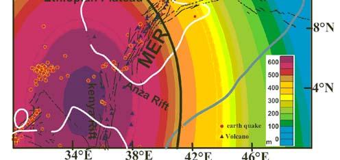
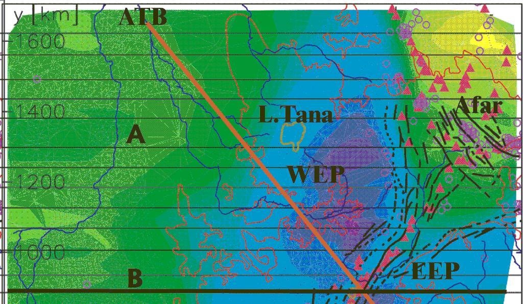
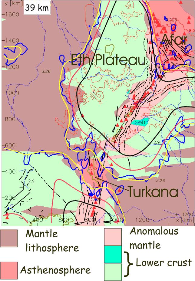
4 Regional setting Zagros Orogenic front Nubia Western Rift Image source: SRTM Red Sea Contents WEP Database Eastern Rift Afar MER EEP Arabia 20 N Topography, tectonics, geology Gulf of Aden Somalia MER=Main Ethiopian Rift EARS=(MER, Afar, Eastern Rift systems). Methodology TC=Tanzanian Craton Isostasy 0 Examples from the 3D modelling TC Indian Key results ocean of the 3D modelling Summary WEP=Western Ethiopian Plateau EEP=Eastern Ethiopian Plateau


 h =")
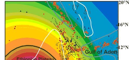
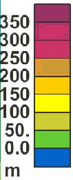
5 Topography and tectonic setting Merged topography and bathymetry, data source: GTOPO30, Smith and Sandwell (1997) h = Earthquakes t = Volcanoes
6 Database
 1.")
 (black( black) 2.")
 (Land: green, Sea: blue)")
 Important data")

7 Gravity database Gravity stations: (~ 45000) 1. Geological Survey of Ethiopia (GSE) (black( black) 2. Bureau Gravimetrique Internat. (BGI) (Land: green, Sea: blue) 3. GETECH and Sudan Geological Authority (red) Important data gaps unsurveyed confidential/or or not accessible Estimated Error: x10-5 m/s 2


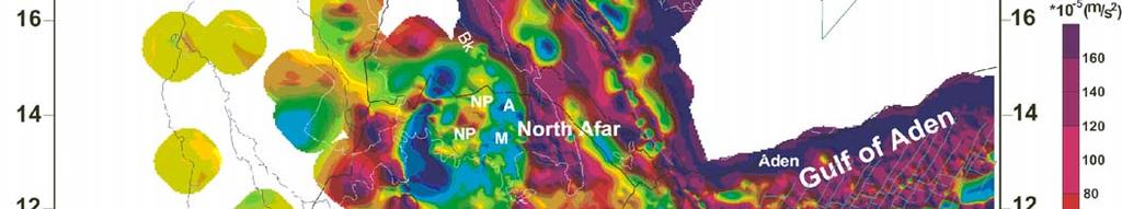
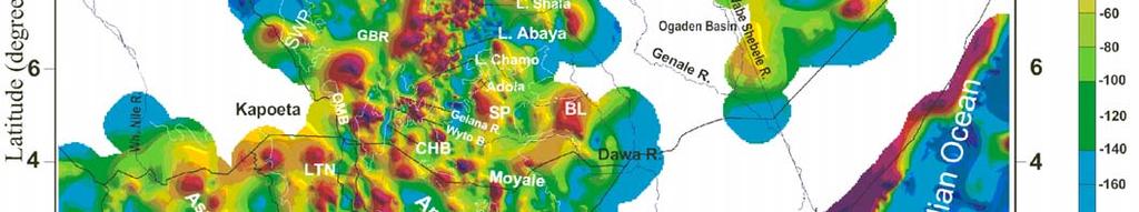
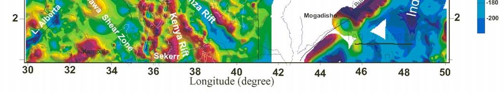
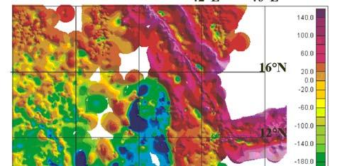
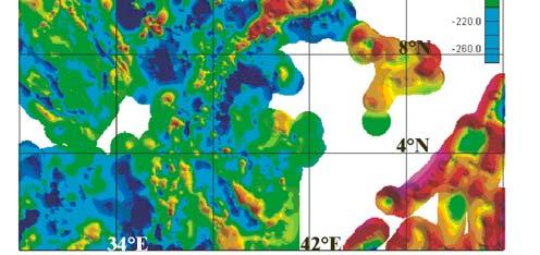
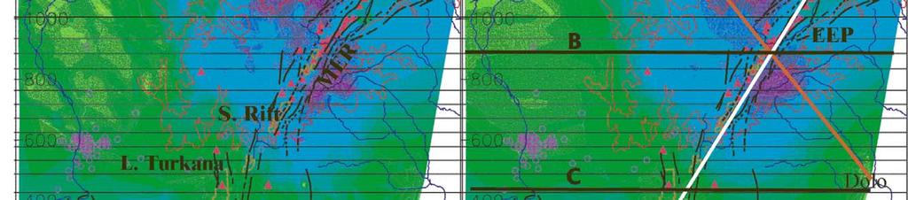
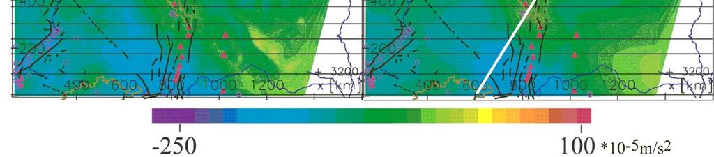
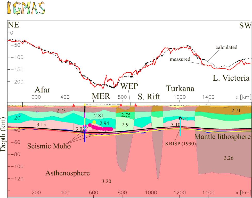
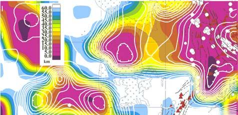
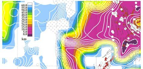
8 Bouguer anomaly map Positive Bouguer anomalies: along fracture systems of Gulf of Aden, Indian Ocean and Red Sea axial zone. Relative positive anomalies: Afar, Anza cross rift,, Eastern Sudan. Negative anomalies MER, KR, Western Rift, Plateaus of Ethiopia, Kenya and Saudi Arabia. Seismic experiments Berckhemer et al (Ethiopia)) and KRISP in Kenya EAGLE ( ) 2004) X10-5 m/s 2 3-D modelling area
9 Geometry and density information Topography and geography Geology, tectonics Crustal densities Density measurements in Ethiopia (~ 800) Density information from eastern Sudan Density from chemical composition data Constraints from seismic Afar experiment (1970); KRISP (1990) & EAGLE ( ) 2004) Axial thinning:turkana (KRISP, 1900); NMER (Keller et al and EAGLE). Low velocity: ( km/s) in Afar (Berckhemer,1975). Velocity-density conversions: Sobolev & Babeyko (1994)
10 Methodology

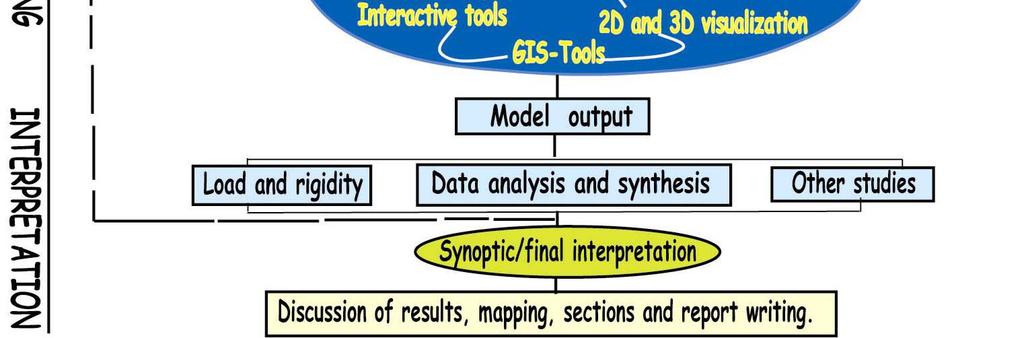
11 3-D density modelling: process
12 Isostasy Why is it necessary to investigate isostasy? For more constraints (e.g. isostatic Moho) For geological correlation Isostatic models Interpretation Study the effect of dynamic topography


13 Isostatic models Vening-Meinesz (VM) modelled Moho (D= Nm, Te= 10 km), Isostatic regional gravity


14 Isostatic residual field Woldetinsae & Götze (2005)
15 Dynamic topography Dynamic topography ~600m (Grand) ~400m (Slab) Dynamic topography is generated by flow within the mantle Total topography= (static+dynamic) Crust Mantle Sublithospheric mantle Moho? Regional compensation Local compensation (Airy)


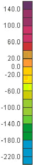
16 Dynamic topography & isostatic residual field Grand Slab Dynamic topographic models Data source: Lithgow-Bertelloni, pers. comm. Residual fields (x10-5 m/s 2 )
17 Modelling


18 IGMAS Howfeatures we define geometry? Geometry input Automatically triangulated geometry Graphical integration of constraining data Interactive modification ASCII output, postscript Calculation of: Gravity, gravity gradients, potential, geoid undulation, remanent & induced magnetic field.

19 General structure of the model Densities: Mg/m 3

20 Modelling results and interpretation Measured gravity Modelled gravity
")
21 Crustal models N Red Sea (A) Somalia
")
22 Crustal models Red Sea N (B) Somalia
")
23 Crustal models N Red Sea (C) Somalia

24 Rift axial


25 Rift perpendicular

26 Wide to narrow rift

27 Wide to narrow rift
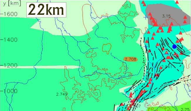
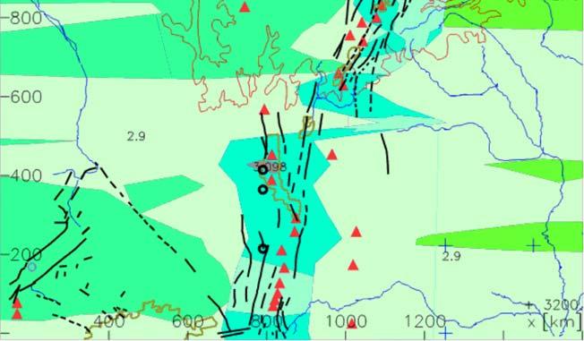
28 Horizontal cross-sections sections
29 Moho and basement


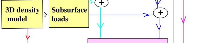
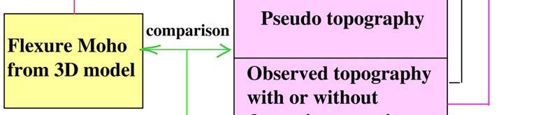
30 Moho from 3D model Shallowest Moho in Afar: ~16 km. Deepest Moho in WEP: 48km. Mean Moho: ~30km. The maximum load in WEP: ~8x10 18 kg/m 2 and induces a downward flexure of the Moho from average 35km to about 45km.


31 Basement topography 12 N Basement topography varies from few 100 m to 7 km. 8 N Deep basement exists in the rift, south west Ethiopia, Afar, Turkana and Eastern Sudan related to sedimentary structures. 4 N Shallow basement corresponds to the Precambrian structures.
32 Rigidity
33 Effective elastic thickness/rigidity Coherence/admittance Require large areas Difficult to include internal loads Methods and results are in many cases controversial (Convolution method, e.g. Braitenberg et al. 2002) Possible to include both external and internal loads No need to calculate admittance Higher resolution is possible Input: Moho geometry and total load from a 3D model


34 Rigidity TGD TGD Summary results MER Rigidity estimates from this work and previous work are different in MER. Turkana...without internal load Te All the models show low rigidity in highly tectonized zones of Afar and Turkana. Precambrian areas have medium to high rigidity....with internal load In Afar, the TGD is marked by change of lithospheric strength in all models.
35 Summary A new consistent regional gravity database; Bouguer gravity and isostatic residual maps; Isostatic models; A new regional 3-D density model using old and recent constraints; Moho and basement topography maps constrained where possible;
36 The 3D model offers quantitative estimates of sedimentary thicknesses; The controls on rift architecture are: sediment loading, asthenospheric upwelling (40 km depth and 300 km wide) ) and lower-crustal modifications; Elastic thickness estimates: Te Afar and Turkana: : km; Te Plateau (WEP, EEP), MER: km; Te Western rift, eastern Sudan basin: km; Te Sudan craton: : km.
")


37 Acknowledgement I thank The Geological Survey of Ethiopia (GSE) for permission to use most of the data sets and information. The research is supported by a grant from KAAD,, Germany. Gysers in Dallol-Afar (Ethiopia) All members at the Institute of Geosciences of CAU and FU Berlin for useful discussions and friendship.

38 Rigidity TGD= Tendaho-Goba Goba adad discontinuity Without dynamic topography Slab dynamic topography TGD...Without internal load Te MER MER Turkana Turkana...With internal load
39 Fault systems Latitude Major rivers fault systems (CGMW, 1968) Coast line Longitude
40 Isostasy
41 Rigidity


42 Rigidity estimation Pseudo topography (PpT) Source:
Global Tectonics. Kearey, Philip. Table of Contents ISBN-13: Historical perspective. 2. The interior of the Earth.
 Global Tectonics Kearey, Philip ISBN-13: 9781405107778 Table of Contents Preface. Acknowledgments. 1. Historical perspective. 1.1 Continental drift. 1.2 Sea floor spreading and the birth of plate tectonics.
Civilization exists by geologic consent, subject to change without notice William Durant
 89.325 Geology for Engineers Plate Tectonics Civilization exists by geologic consent, subject to change without notice William Durant Properties of the Planets Size Density Distance from sun Chemistry
GeoPRISMS RIE Workshop 2010
 GeoPRISMS RIE Workshop 2010 Rift initiation - East Africa and Afar Derek Keir - University of Leeds GeoPRISMS RIE Workshop 2010 Rift initiation - East Africa and Afar Derek Keir - University of Leeds Conclusions
9. Density Structure. The Australian Continent: A Geophysical Synthesis Density Structure
 84 The Australian Continent: A Geophysical Synthesis Density Structure 9. Density Structure Although the primary focus for the development of the AuSREM model was the creation of 3-D seismic wavespeed
Wilson cycle. 1. Intracontinental rift 2. From rifting to drifting
 Wilson cycle 1. Intracontinental rift 2. From rifting to drifting Stages of the Wilson Cycle Intracontinental Rifts 1. Contemporary examples (EAR, RGR, Baikal, Rhine graben) 2. Mechanical aspects. Characteristics
OCN 201: Seafloor Spreading and Plate Tectonics I
 OCN 201: Seafloor Spreading and Plate Tectonics I Revival of Continental Drift Theory Kiyoo Wadati (1935) speculated that earthquakes and volcanoes may be associated with continental drift. Hugo Benioff
Defining the former elevation and shape of the lithosphere, in particular the elevation of the Earth s surface,
 Isostasy in Move Defining the former elevation and shape of the lithosphere, in particular the elevation of the Earth s surface, is important in the restoration of a model as it aids in reducing uncertainty
The thermal and density structure of passive margins
 The thermal and density structure of passive margins Magdalena Scheck-Wenderoth, Yuriy Maystrenko, Julia Autin, Hans Jürgen Götze, Sabine Schmidt, Christian Reichert basins in their plate-tectonic setting
GRAVITY AND ISOSTASY
 GRAVITY AND ISOSTASY Gravity The Geoid is the oblate spheroid -- the sea level surface over the entire Earth's surface Physically, the Geoid is an equipotential surface for gravity (i.e. the surface for
The continental lithosphere
 Simplicity to complexity: The continental lithosphere Reading: Fowler p350-377 Sampling techniques Seismic refraction Bulk crustal properties, thickness velocity profiles Seismic reflection To image specific
OZ SEEBASE TM. Datasets. Digital Elevation Model
 Digital Elevation Model 10 Digital Elevation Models (DEM s) often show the youngest structures, and any active geological structures. They are widely used for neotectonic analysis. The composition of eroding
OCN 201 Physiography of the Seafloor
 OCN 201 Physiography of the Seafloor Hypsometric Curve for Earth s solid surface Note histogram Hypsometric curve of Earth shows two modes. Hypsometric curve of Venus shows only one! Why? Ocean Depth vs.
LithoFLEX Tutorial INTRODUCTION 2 FREE MAPPING SOFTWARE GEOSOFT 3 DATA FORMAT 3 DATA DESCRIPTION / DUMMY VALUES 4 STUDY AREA 5
 LithoFLEX Tutorial INTRODUCTION 2 FREE MAPPING SOFTWARE GEOSOFT 3 DATA FORMAT 3 DATA DESCRIPTION / DUMMY VALUES 4 STUDY AREA 5 A. GRAVITY FORWARD CALCULATION 8 a) GRAVITY EFFECT OF AN UNDULATING LAYER
The anomalous high transverse ridge developed along a transform fault. Speaker: Yen-Fu Chen
 The anomalous high transverse ridge developed along a transform fault Speaker: Yen-Fu Chen Reference Anne E. Deschamps, Serge E. Lallemand, and Jean-Yves Collot, 1998, A detailed study of the Gagua Ridge:
REDUCING NON-UNIQUENESS IN SATELLITE GRAVITY INVERSION USING SEISMIC TOMOGRAPHY AND 3D OBJECT ORIENTED IMAGE ANALYSIS TECHNIQUES
 REDUCING NON-UNIQUENESS IN SATELLITE GRAVITY INVERSION USING SEISMIC TOMOGRAPHY AND 3D OBJECT ORIENTED IMAGE ANALYSIS TECHNIQUES ISLAM FADEL MARK VAN DER MEIJDE NORMAN KERLE Research Topic: Reducing the
Gravitational constraints
 Gravitational constraints Reading: Fowler p172 187 Gravity anomalies Free-air anomaly: g F = g g( λ ) + δg obs F Corrected for expected variations due to the spheroid elevation above the spheroid Bouguer
Lecture 2: Gravity, Isostasy and Flexure
 Lecture 2: Gravity, Isostasy and Flexure Read pages 42-51 in KK&V You can access all of KK&V through ereserves (password: yf160) Homework 1 is due next Thursday Gravity: theory and measurements Newton:
The lithospheric density structure of the Eastern Alps
 Tectonophysics 414 (2006) 145 155 www.elsevier.com/locate/tecto The lithospheric density structure of the Eastern Alps Jörg Ebbing a, *, Carla Braitenberg b, Hans-Jürgen Götze c a Geological Survey of
Total gravitational field is sum of contributions from all masses.
 Gravity force (acceleration) vs potential (energy) acceleration (g) => GM/r 2 Potential => - GM/r G is Newton s gravitational constant 6.67x10⁻¹¹ (S.I. units) you should determine what the S.I. units are
The influence of short wavelength variations in viscosity on subduction dynamics
 1 Introduction Deformation within the earth, driven by mantle convection due primarily to cooling and subduction of oceanic lithosphere, is expressed at every length scale in various geophysical observations.
Earth s Continents and Seafloors. GEOL100 Physical Geology Ray Rector - Instructor
 Earth s Continents and Seafloors GEOL100 Physical Geology Ray Rector - Instructor OCEAN BASINS and CONTINENTAL PLATFORMS Key Concepts I. Earth s rocky surface covered by of two types of crust Dense, thin,
Geophysical Surveys of The Geothermal System of The Lakes District Rift, Ethiopia
 Geophysical Surveys of The Geothermal System of The Lakes District Rift, Ethiopia By: Befekadu Oluma By: Geophysics Department Geological Survey of Ethiopia The formation of the rift was preceded by a
A) B) C) D) 4. Which diagram below best represents the pattern of magnetic orientation in the seafloor on the west (left) side of the ocean ridge?
 B) C) D) 4. Which diagram below best represents the pattern of magnetic orientation in the seafloor on the west (left) side of the ocean ridge?") 1. Crustal formation, which may cause the widening of an ocean, is most likely occurring at the boundary between the A) African Plate and the Eurasian Plate B) Pacific Plate and the Philippine Plate C)
1. Crustal formation, which may cause the widening of an ocean, is most likely occurring at the boundary between the A) African Plate and the Eurasian Plate B) Pacific Plate and the Philippine Plate C)
Advanced Workshop on Evaluating, Monitoring and Communicating Volcanic and Seismic Hazards in East Africa.
 2053-8 Advanced Workshop on Evaluating, Monitoring and Communicating Volcanic and Seismic Hazards in East Africa 17-28 August 2009 Seismicity of the East African Rift Atalay Ayele W. Addis Ababa University
B6 Isostacy. B6.1 Airy and Pratt hypotheses. Geophysics 210 September 2008
 B6 Isostacy B6.1 Airy and Pratt hypotheses Himalayan peaks on the Tibet-Bhutan border In the 19 th century surveyors used plumblines and theodolites to map India. A plumb line was used when measuring the
Crustal thinning between the Ethiopian and East African plateaus from modeling Rayleigh wave dispersion
 GEOPHYSICAL RESEARCH LETTERS, VOL. 33,, doi:10.1029/2006gl025687, 2006 Crustal thinning between the Ethiopian and East African plateaus from modeling Rayleigh wave dispersion Margaret H. Benoit, 1 Andrew
GENERAL GEOLOGY Fall Chapter 18: The Sea Floor. Partial Examination IV Study Guide Dr. Glen S. Mattioli
 GENERAL GEOLOGY 1113-005 Fall 2008 Partial Examination IV Study Guide Dr. Glen S. Mattioli Note that these are NOT questions, but rather are a list of topics that we have covered either in class or are
The crust and upper mantle structure of the Afar region from 3D gravity inversion
 The crust and upper mantle structure of the Afar region from 3D gravity inversion Alemayo, Gebreselassie Gebreanenia Thesis submitted for the degree of Master of Science in Geoscience Geo-hazard Programme
OCN 201 Physiography of the Seafloor
 OCN 201 Physiography of the Seafloor 1 Ocean Depth versus Continental Height Why do we have dry land? Solid surface of Earth is dominated by two levels: Land with a mean elevation of +840 m (29% of Earth
 Sedimentary Basin Analysis http://eqsun.geo.arizona.edu/geo5xx/geos517/ Sedimentary basins can be classified based on the type of plate motions (divergent, convergent), type of the lithosphere, distance
The Structure of the Earth and Plate Tectonics
 The Structure of the Earth and Plate Tectonics Agree or Disagree? 1. The Earth if made up of 4 different layers. 2. The crust (where we live) can be made of either less dense continental crust or the more
5. Gravity. 5.1 Geoid Variations. The Australian Continent: A Geophysical Synthesis Gravity
 34 The Australian Continent: A Geophysical Synthesis Gravity 5. Gravity Gravity data map subtle changes in the Earth s gravitational field caused by variations in the density of the underlying materials.
The Earth s Structure from Travel Times
 from Travel Times Spherically symmetric structure: PREM - Crustal Structure - Upper Mantle structure Phase transitions Anisotropy - Lower Mantle Structure D D - Structure of of the Outer and Inner Core
Plate Tectonics - Demonstration
 Name: Reference: Prof. Larry Braile - Educational Resources Copyright 2000. L. Braile. Permission granted for reproduction for non-commercial uses. http://web.ics.purdue.edu/~braile/indexlinks/educ.htm
Marine Science and Oceanography
 Marine Science and Oceanography Marine geology- study of the ocean floor Physical oceanography- study of waves, currents, and tides Marine biology study of nature and distribution of marine organisms Chemical
Chapter 7 Plate Tectonics
 Chapter 7 Plate Tectonics Earthquakes Earthquake = vibration of the Earth produced by the rapid release of energy. Seismic Waves Focus = the place within the Earth where the rock breaks, producing an earthquake.
Horizontal gradient and band-pass filter of aeromagnetic data image the subsurface structure; Example from Esh El Mellaha Area, Gulf of Suez, Egypt.
 Horizontal gradient and band-pass filter of aeromagnetic data image the subsurface structure; Example from Esh El Mellaha Area, Gulf of Suez, Egypt. Essam Aboud 1, Serguei Goussev 2, Hassan Hassan 2, Suparno
topography half is commonly represented in maps, and how it interacts with
 Topography T. Perron 12.001 We ll spend a large fraction of the second half of the course discussing Earth s surface. Today we ll do two things: First, we ll discuss the ways topography is commonly represented
Geophysik mittels Satellitenbeobachtungen - Von der Struktur zur dynamischen Betrachtung der Erde
 Geophysik mittels Satellitenbeobachtungen - Von der Struktur zur dynamischen Betrachtung der Erde Jörg Ebbing Institut für Geowissenschaften Christian-Albrechts-Universität zu Kiel 102. Sitzung des FKPE
IV OTHER TYPES OF BASINS
 IV OTHER TYPES OF BASINS 1-Strike-slip basins 2-Cratonic basins 3 Late orogenic basins and more 1 Tectonic setting of strike-slip faulting Woodcock 1986 2 Seismic examples of stike-slip faults «!Flower
SEDIMENTARY BASINS Red Sea Coast of Egypt. by Prof. Dr. Abbas Mansour
 SEDIMENTARY BASINS Red Sea Coast of Egypt by Prof. Dr. Abbas Mansour Sedimentary basins Sedimentary basins are, in a very broad sense, all those areas in which sediments can accumulate to considerable
4. Basins due to orogenic loading
 4. Basins due to orogenic loading Orogenic loading and lithospheric flexure: peripheral vs. retroarc foreland basin Elastic vs. viscoelastic models Gravity anomalies, foreland flexure, and the development
Seismotectonics of intraplate oceanic regions. Thermal model Strength envelopes Plate forces Seismicity distributions
 Seismotectonics of intraplate oceanic regions Thermal model Strength envelopes Plate forces Seismicity distributions Cooling of oceanic lithosphere also increases rock strength and seismic velocity. Thus
Global geophysics and wave propagation
 Global geophysics and wave propagation Reading: Fowler p76 83 Remote sensing Geophysical methods Seismology Gravity and bathymetry Magnetics Heat flow Seismology: Directly samples the physical properties
USU 1360 TECTONICS / PROCESSES
 USU 1360 TECTONICS / PROCESSES Observe the world map and each enlargement Pacific Northwest Tibet South America Japan 03.00.a1 South Atlantic Arabian Peninsula Observe features near the Pacific Northwest
Comparison of the ancient Keweenaw Mid-Continent Rift System and the active East. African Rift System
 Neier 1 Emily Neier Mentor: Steve Mattox GEO 485 28 April 2016 Comparison of the ancient Keweenaw Mid-Continent Rift System and the active East African Rift System Abstract The active East African Rift
Chapter 02 The Sea Floor
 Chapter 02 The Sea Floor Multiple Choice Questions 1. One of the following is not one of the world's major ocean basins: A. Atlantic Ocean B. Arctic Ocean C. Indian Ocean D. Antarctic Ocean E. Pacific
ESA training. Gravity, magnetics and gradients for mapping and modelling. Jörg Ebbing. Department of Geosciences Kiel University
 ESA training Gravity, magnetics and gradients for mapping and modelling Jörg Ebbing Department of Geosciences Kiel University Contributions from: Eldar Baykiev (Trondheim), Des Fitzgerald (Melbourne),
Isostacy: Compensation of Topography and Isostatic Geoid Anomalies
 Isostacy: Compensation of Topography and Isostatic Geoid Anomalies November 3, 2016 1 Isostacy One of the major goals of interpreting planetary gravity fields is to understand how topography positive (
What Are Tectonic Plates?
 Plate Tectonics The theory that the Earth s outermost layer is fragmented into a dozen or more large and small plates that move relative to one another as they ride on top of hotter, more mobile material.
Plate Tectonics on a Plane. Observations related to plate tectonics " " Plate tectonic theory types of plate boundaries!
 Plate Tectonics on a Plane Scripps Inst. Of Oceanography" Observations related to plate tectonics " Ocean and continent topography, hypsometry, and crustal thickness. Global seismicity, Benioff zones,
Isostasy, Bathymetry and the Physiography of the Ocean Floor
 Isostasy, Bathymetry and the Physiography of the Ocean Floor EPSS 15 Spring 2017 Ad art for NBC Radio, 1939 Archimedes (c. 287 BCE 212 BCE) Greek mathematician, physicist and engineer Archimedes Principle:
Late 20 th Century Tests of the Continental Drift Hypothesis
 Late 20 th Century Tests of the Continental Drift Hypothesis 5 Characteristics of the Ocean Trenches Unless otherwise noted the artwork and photographs in this slide show are original and by Burt Carter.
44031 Crustal Compensation Rate In Central Anatolian Region And Comparison Of Seismic Activity
 44031 Crustal Compensation Rate In Central Anatolian Region And Comparison Of Seismic Activity B. Oruç* (Kocaeli University), T. Sönmez (Kocaeli University), E. Ulutaş (Kocaeli University), H.H. Selim
by west-dipping subduction of the North American Plate
 GSA Data Repository 2019133 Supplementary information for Kimberlite magmatism induced by west-dipping subduction of the North American Plate Wenbo Zhang 1*, Stephen T. Johnston 1, and Claire A. Currie
Mountain Building. Mountain Building
 Mountain Building Mountain building has occurred during the recent geologic past American Cordillera the western margin of the Americas from Cape Horn to Alaska Includes the Andes and Rocky Mountains Alpine
Earth Systems Science Chapter 7. Earth Systems Science Chapter 7 11/11/2010. Seismology: study of earthquakes and related phenomena
 Earth Systems Science Chapter 7 I. Structure of the Earth II. Plate Tectonics The solid part of the earth system includes processes, just like the atmosphere and oceans. However, the time scales for processes
COURSE OUTLINE GEOLOGY 101, Sec 002 Fall 2008, Diecchio Text: Lutgens, Tarbuck and Tasa, Essentials of Geology, 10 th edition
 COURSE OUTLINE GEOLOGY 101, Sec 002 Fall 2008, Diecchio Text: Lutgens, Tarbuck and Tasa, Essentials of Geology, 10 th edition Overview Of Earth ch 1 Earth's place in solar system, galaxy, universe Atmosphere,
Karl Mueller QUATERNARY RIFT FLANK UPLIFT OF THE PENINSULAR RANGES IN BAJA AND SOUTHERN CALIFORNIA BY REMOVAL OF MANTLE LITHOSPHERE
 QUATERNARY RIFT FLANK UPLIFT OF THE PENINSULAR RANGES IN BAJA AND SOUTHERN CALIFORNIA BY REMOVAL OF MANTLE LITHOSPHERE August 2013 Quaternary Rift Flank Uplift of the Peninsular Ranges in Baja and Southern
Evolution of Continents Chapter 20
 Evolution of Continents Chapter 20 Does not contain complete lecture notes. Mountain belts Orogenesis the processes that collectively produce a mountain belt Includes folding, thrust faulting, metamorphism,
Lab 1: Plate Tectonics April 2, 2009
 Name: Lab 1: Plate Tectonics April 2, 2009 Objective: Students will be introduced to the theory of plate tectonics and different styles of plate margins and interactions. Introduction The planet can be
MARINE GEOLOGY & GEOGRAPHY
 MARINE GEOLOGY & GEOGRAPHY Bathymetry BATHYMETRY BATHYMETRY THE UNDERWATER EQUIVALENT TO TOPOGRAPHY THE STUDY OF WATER DEPTH A BATHYMETRIC MAP SHOWS FLOOR RELIEF OR TERRAIN AS CONTOUR LINES Bathymetry
Strike-Slip Faults. ! Fault motion is parallel to the strike of the fault.
 Strike-Slip Faults! Fault motion is parallel to the strike of the fault.! Usually vertical, no hanging-wall/footwall blocks.! Classified by the relative sense of motion. " Right lateral opposite block
2008 Monitoring Research Review: Ground-Based Nuclear Explosion Monitoring Technologies
 STRUCTURE OF THE KOREAN PENINSULA FROM WAVEFORM TRAVEL-TIME ANALYSIS Roland Gritto 1, Jacob E. Siegel 1, and Winston W. Chan 2 Array Information Technology 1 and Harris Corporation 2 Sponsored by Air Force
Earthquakes. Earthquakes are caused by a sudden release of energy
 Earthquakes Earthquakes are caused by a sudden release of energy The amount of energy released determines the magnitude of the earthquake Seismic waves carry the energy away from its origin Fig. 18.1 Origin
Specific gravity field and deep crustal structure of the Himalayas east structural knot
 49 4 2006 7 CHINESE JOURNAL OF GEOPHYSICS Vol. 49, No. 4 Jul., 2006,,.., 2006, 49 (4) :1045 1052 Teng J W, Wang Q S, Wang GJ, et al. Specific gravity field and deep crustal structure of the Himalayas east
GRAVIMETRIC MAP OF CHILE. Services Mining and Engineering Geophysics Instituto Geográfico Militar
 GRAVIMETRIC MAP OF CHILE Araneda M., Rivas L., Avendaño M, Sottolichio G., Rubio W. Services Mining and Engineering Geophysics segmi@netexpress.cl) Instituto Geográfico Militar (lrivas@igm.cl) Abstract
Blind fault Configuration in Osaka, Japan based on 2D gravity inversion
 Blind fault Configuration in Osaka, Japan based on 2D gravity inversion N. Inoue & N. Kitada Geo-research Institute, Osaka, Japan K. Takemura Institute for Geothermal Sciences, Kyoto University, Beppu,
TAKE HOME EXAM 8R - Geology
 Name Period Date TAKE HOME EXAM 8R - Geology PART 1 - Multiple Choice 1. A volcanic cone made up of alternating layers of lava and rock particles is a cone. a. cinder b. lava c. shield d. composite 2.
Introduction To Plate Tectonics Evolution. (Continents, Ocean Basins, Mountains and Continental Margins)
") Introduction To Plate Tectonics Evolution (Continents, Ocean Basins, Mountains and Continental Margins) Geo 386 (Arabian Shield Course) Dr. Bassam A. A. Abuamarah Mohanna G E O 3 8 6 A R A B I A N G E
Introduction To Plate Tectonics Evolution (Continents, Ocean Basins, Mountains and Continental Margins) Geo 386 (Arabian Shield Course) Dr. Bassam A. A. Abuamarah Mohanna G E O 3 8 6 A R A B I A N G E
Edge Driven Convection and Iceland
 Edge Driven Convection and Iceland Scott D. King Department of Earth and Atmospheric Sciences Purdue University, West Lafayette, Indiana One of the alternative hypotheses for hotspot volcanism is Edge-Driven
The Earth s Structure. The Lithosphere and Tectonic. The Lithosphere and Tectonic. System. Chapter 12. The Earth s Interior
 The Lithosphere and Tectonic System Chapter 12 The Lithosphere and Tectonic System The theory describing the changing configuration of the continents through time is called plate tectonics. Plate tectonic
 http://foundation.aapg.org/students/undergraduate/weeks.cfm Tim Carr - West Virginia University 3 Potential Fields Indirect Visualization Density and Magnetization Gravity and Magnetic Exploration Locate
Our Dynamic Earth Unit Unit 5
 EARTH SCIENCE REGENTS - SOTO Our Dynamic Earth Unit Unit 5 Mr. Soto - Key 1/1/2013 Our Dynamic Earth Vocabulary List 1 Directions: Define each vocabulary word provided below. You may have to use your Earth
Chapter 2 Plate Tectonics and the Ocean Floor
 Chapter 2 Plate Tectonics and the Ocean Floor Matching. Match the term or person with the appropriate phrase. You may use each answer once, more than once or not at all. 1. hydrothermal vents A. convergent
Earth. Temp. increases with depth, the thermal gradient is 25 o C/km. Pressure and density also increase with depth.
 Plate Tectonics Earth Earth overall average density = 5.5 g/cm 3. Temp. increases with depth, the thermal gradient is 25 o C/km. Pressure and density also increase with depth. Spheroid: with a longer major
Geography of the world s oceans and major current systems. Lecture 2
 Geography of the world s oceans and major current systems Lecture 2 WHY is the GEOMORPHOLOGY OF THE OCEAN FLOOR important? (in the context of Oceanography) WHY is the GEOMORPHOLOGY OF THE OCEAN FLOOR important?
SUPPLEMENTARY INFORMATION
 The major uncertainties in our model predictions arise from the input parameters, which include mantle density models (i.e. seismic tomography and choices about scaling velocities to temperature), crustal
Neogene Uplift of The Barents Sea
 Neogene Uplift of The Barents Sea W. Fjeldskaar A. Amantov Tectonor/UiS, Stavanger, Norway FORCE seminar April 4, 2013 The project (2010-2012) Funding companies Flat Objective The objective of the work
ANOTHER MEXICAN EARTHQUAKE! Magnitude 7.1, Tuesday Sept. 19, 2017
 ANOTHER MEXICAN EARTHQUAKE! Magnitude 7.1, Tuesday Sept. 19, 2017 Why is there no oceanic crust older than 200 million years? SUBDUCTION If new oceanic crust is being continuously created along the earth
Chapter 16. Mountain Building. Mountain Building. Mountains and Plate Tectonics. what s the connection?
 Chapter 16 Mountains and Plate Tectonics what s the connection? Mountain Building Most crustal deformation occurs along plate margins. S.2 Active Margin Passive Margin Mountain Building Factors Affecting
Topic 5: The Dynamic Crust (workbook p ) Evidence that Earth s crust has shifted and changed in both the past and the present is shown by:
 Evidence that Earth s crust has shifted and changed in both the past and the present is shown by:") Topic 5: The Dynamic Crust (workbook p. 65-85) Evidence that Earth s crust has shifted and changed in both the past and the present is shown by: --sedimentary horizontal rock layers (strata) are found
Topic 5: The Dynamic Crust (workbook p. 65-85) Evidence that Earth s crust has shifted and changed in both the past and the present is shown by: --sedimentary horizontal rock layers (strata) are found
FORWARD MODELING OF THE GEOID ANOMALY USING SPHERICAL HARMONICS: APPLICATIONS IN THE SIERRA NEVADA. Alissa C Scire
 FORWARD MODELING OF THE GEOID ANOMALY USING SPHERICAL HARMONICS: APPLICATIONS IN THE SIERRA NEVADA by Alissa C Scire A Prepublication Manuscript Submitted to the Faculty of the DEPARTMENT OF GEOSCIENCES
Refer to the map on page 173 to answer the following questions.
 Chapter 8-1 Plate Tectonics 1. Brainstorm the type of evidence that would indicate a climate change and how this evidence supports the theory of continental drift. Tropical fossils in cold regions Evidence
The Structure of the Earth and Plate Tectonics
 The Structure of the Earth and Plate Tectonics Structure of the Earth The Earth is made up of 4 main layers: Inner Core Outer Core Mantle Crust Crust Mantle Outer core Inner core The Crust This is where
Lecture Outline Friday January 12 Friday January 19, 2018
 Lecture Outline Friday January 12 Friday January 19, 2018 Questions?? Key Points for today The structure of the Earth Introduction to Plate Tectonic Theory and Convection Chapter 2 Development of the Plate
Tomographic imaging of P wave velocity structure beneath the region around Beijing
 403 Doi: 10.1007/s11589-009-0403-9 Tomographic imaging of P wave velocity structure beneath the region around Beijing Zhifeng Ding Xiaofeng Zhou Yan Wu Guiyin Li and Hong Zhang Institute of Geophysics,
Copyright McGraw-Hill Education. All rights reserved. No reproduction or distribution without the prior written consent of McGraw-Hill Education
 Copyright McGraw-Hill Education. All rights reserved. No reproduction or distribution without the prior written consent of McGraw-Hill Education Tibetan Plateau and Himalaya -southern Asia 11.00.a VE 10X
WHAT IS THE THICKNESS OF EARTH S CRUST?
 WHAT IS THE THICKNESS OF EARTH S CRUST? Image: Yerko Espinoza/shutterstock.com Andy Alvey, Alan Roberts* and Nick Kusznir discuss how a new global map of crustal thickness is illuminating complexity in
Earth Science, (Tarbuck/Lutgens) Chapter 10: Mountain Building
 Chapter 10: Mountain Building") Earth Science, (Tarbuck/Lutgens) Chapter 10: Mountain Building 1) A(n) fault has little or no vertical movements of the two blocks. A) stick slip B) oblique slip C) strike slip D) dip slip 2) In a(n) fault,
Earth Science, (Tarbuck/Lutgens) Chapter 10: Mountain Building 1) A(n) fault has little or no vertical movements of the two blocks. A) stick slip B) oblique slip C) strike slip D) dip slip 2) In a(n) fault,
Lab 8: Gravity and Isostasy (35 points)
") it's not the most important thing in your life right now. But what is important is gravity. Arnold Schwarzenegger as Colonel John Matrix, Commando (Check out this classic of American cinema!) Lab 8: Gravity
it's not the most important thing in your life right now. But what is important is gravity. Arnold Schwarzenegger as Colonel John Matrix, Commando (Check out this classic of American cinema!) Lab 8: Gravity
High-Harmonic Geoid Signatures due to Glacial Isostatic Adjustment, Subduction and Seismic Deformation
 High-Harmonic Geoid Signatures due to Glacial Isostatic Adjustment, Subduction and Seismic Deformation L.L.A. Vermeersen (1), H. Schotman (1), M.-W. Jansen (1), R. Riva (1) and R. Sabadini (2) (1) DEOS,
12. The diagram below shows the collision of an oceanic plate and a continental plate.
 Review 1. Base your answer to the following question on the cross section below, which shows the boundary between two lithospheric plates. Point X is a location in the continental lithosphere. The depth
MARINE GEOLOGY & GEOGRAPHY
 MARINE GEOLOGY MARINE GEOLOGY & GEOGRAPHY Marine Geology 4 LAYERS OF THE EARTH CRUST THICKNESS: VARIES BETWEEN OCEAN & CONTINENTS 5-40 KM STATE: SOLID ELEMENTS: SILICON, ALUMINUM, CALCIUM, SODIUM, POTASSIUM
General Oceanography Geology 105 Expedition 8 Plate Boundaries Beneath the Sea Complete by Thursday at 11:00 PM
 General Oceanography Geology 105 Expedition 8 Plate Boundaries Beneath the Sea Complete by Thursday at 11:00 PM Name Expedition Objectives Learn about the types of plate boundaries and their key characteristics
Earth system. space. planets. atmosphere. ice sheets. ocean. biosphere, technosphere. solid Earth. gravitation on. orbit, spin, tides
 third lecture Three Lectures: One ESA explorer mission GOCE: earth gravity from space Two Signal Processing on a sphere Three Gravity and earth sciences Earth system space sun moon planets gravitation
Whole Earth Structure and Plate Tectonics
 Whole Earth Structure and Plate Tectonics Processes in Structural Geology & Tectonics Ben van der Pluijm WW Norton+Authors, unless noted otherwise 4/5/2017 14:45 We Discuss Whole Earth Structure and Plate
Name Class Date. 1. What is the outermost layer of the Earth called?. a. core b. lithosphere c. asthenosphere d. mesosphere
 Name Class Date Assessment Geology Plate Tectonics MULTIPLE CHOICE Write the letter of the correct answer in the space provided. 1. What is the outermost layer of the Earth called?. a. core b. lithosphere
Plate Tectonics. entirely rock both and rock
 Plate Tectonics I. Tectonics A. Tectonic Forces are forces generated from within Earth causing rock to become. B. 1. The study of the origin and arrangement of Earth surface including mountain belts, continents,
Continental Margin Geology of Korea : Review and constraints on the opening of the East Sea (Japan Sea)
") Continental Margin Geology of Korea : Review and constraints on the opening of the East Sea (Japan Sea) Han-Joon Kim Marine Satellite & Observation Tech. Korea Ocean Research and Development Institute
Continental Margin Geology of Korea : Review and constraints on the opening of the East Sea (Japan Sea) Han-Joon Kim Marine Satellite & Observation Tech. Korea Ocean Research and Development Institute