Neogene Uplift of The Barents Sea
|
|
|
- Philomena Cook
- 6 years ago
- Views:
Transcription
1 Neogene Uplift of The Barents Sea W. Fjeldskaar A. Amantov Tectonor/UiS, Stavanger, Norway FORCE seminar April 4, 2013
")
2 The project ( )
3 Funding companies Flat
4 Objective The objective of the work was to improve our understanding of the timing, geometry and magnitude of the Neogene and Quaternary erosion and uplift of the Flat Russian and Norwegian parts of the Barents Sea.
5 Outline Plio-Pleistocene glaciations - extent and timing Effects of glaciers Estimates/modelling of glacial erosion Flat Isostatic effects (tilting of reservoirs) Temperature- og maturity effects Estimations of Neogene Erosion
6 Plio-Pleistocene glaciations Flat
7 Deglaciation - last glaciation

8 Glacial-Interglacial cycles From deep sea sediments At least 8 glacial-interglacial cycles over the last years, and maybe 30 cycles since late Pliocene.
9 3 Plio-Pleistocene phases Typical glaciations Ma Ma < 1.0 Ma Knies et al (2009)
10 Plio-Pleistocene Glaciations 1st phase 2nd phase Estimations of Pliocene drainage pattern. 3rd phase Maximum possible ice extent and thicknesses for three periods of Plio- Pleistocene


11 Heat flow Surface temperature Hydrocarbon generation Temperature history Thermal conductivity EFFECTS OF GLACIATIONS ON PETROLEUM SYSTEMS Hydrocarbon leakage? Flat Stress changes Erosion Erosion Ice loads Faults/seal Tilting Faults/ seal Tilting Ridge push Faults
12 Effects Glaciations Surface temperature Thermal conductivity Compaction Isostatic effects Elastic effects Stress effects Erosion Flat Petroleum systems temperature maturity migration routes leakage reservoir quality
13 Glacial erosion
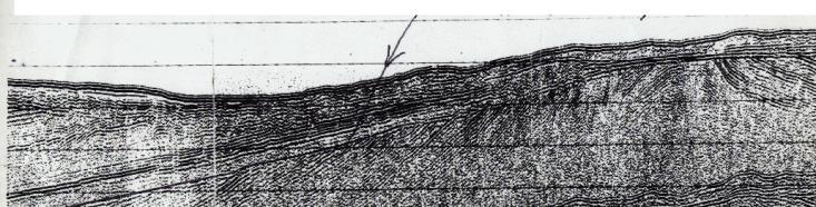
.")
14 Implications Source rock is generally located at too low temperatures to be generating hc recently. Quantifying the amount of erosion in the glacial period will be an important step in the direction of quantification of max burial (time and amount). This is important for the understanding of petroleum systems in the Barents Sea.

15 Effects of glaciations Glacial erosion Flat
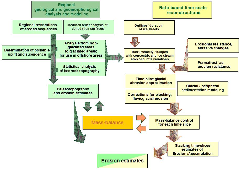
16 Morphological modelling Flat

17 Morphological modelling Concentric pattern forms due to low ice velocity under the center, and more rapid basal ice velocity near the margins Different erodability of sedimentary bedrock and basement lithologies Effect of ice streams with enhanced erosional capacity Estimations of Pliocene drainage pattern. Model of pre-glacial landscape with major drainage pattern Illustration of the erosion model

18 Erosion modeling Early phase Mid phase Predict Flat erosion Late phase Knies et al (2009)


19 Plio-Pleistocene Glaciations 1st phase 2nd phase Estimations of Pliocene drainage pattern. 3rd phase Maximum possible ice extent and thicknesses for three periods of Plio- Pleistocene


20 Ice Thickness Module Ice Thickness computed from: 1. Ice margin outline 2. Topography 3. Basal lithology Flat Different marginal slope 4. Ice velocity 5. Floating or frozen base 6. Marginal slope (specified) 7. Continental or ocean margin


21 Ice surface velocities Estimations of Pliocene drainage pattern. Skeleton Fahnestock et al., 1997

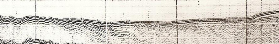
22 Shallow seismic From R. Krapivner, 2006 From E. Musatov, 1999 From E. Musatov, Estimations of Pliocene drainage pattern From A. Amantov, 1992 From R. Krapivner, 2006 Net Bedrock Erosion From A. Amantov,

23 Zone of maximum glacial erosion Flat Maximum glacial erosion has stable position along the Atlantic coast, while eastern flank is migrating due to ice sheet grow and decay
")
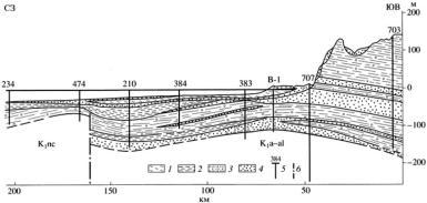
24 Plio-Pleistocene erosion and deposition (Amantov, unpublished) Flat
25 Isostatic response
-liquid.")
26 Archimedes of Syracuse (Greek: Ἀρχιμήδης) Archimedes is generally considered to be the greatest mathematician of antiquity and one of the greatest of all time A buoyancy force arises when a solid object is placed into an (ideal)-liquid. The buoyancy force is specified by Archimede s Principle which states: the decrease in weight of the object equals the weight of the liquid displaced by the submerged portion of the body.
27 Isostasy Lithosphere Asthenosphere The lithosphere in floating equilibrium on the asthenosphere is isostasy

28 Glacial Isostatic Adjustment Asthenosphere Vertical movement in response to changing burden is called isostatic adjustment The crust is subsiding due to the ice load

29 Asthenosphere When the load is removed, the crust is experiencing uplift - until new equilibrium is established
30 Deglaciation model ( AA1 ) Flat

31 last years Calculated glacial isostasy

32 Observed palaeo shorelines Flat Post-glacial shorelines from Roddines, Porsangerfjord (north Norway)

 -")
33 Observed vs. calculated present rate of uplift Calculated Observed 9 mm/yrs Flat 9 mm/yrs Observed (Vestøl, 2006) - corrected for eustasy

34 Effect of ice model Earth model: A low viscosity asthenosphere (2.5 x Pa s) Lithosphere rigidity 5 x Nm (40 km)

35 Plio-Pleistocene glacier and isostasy < 1.0 Ma Isostasy

36 Petroleum system

37 Isostatic effects on petroleum system Basin in isostatic equilibrium during glaciation. Petroleum system is located in the area near the edge of the glacier. What happens when the ice melts?

38 Isostatic effects on petroleum system Sea level Migration changes direction Basin in isostatic equilibrium during glaciation. Petroleum system is located in the area near the edge of the glacier.
39 Erosion and uplift erosion uplift crust crust mantle mantle

40 Glacial erosion and uplift Isostasy
41 Conclusion-1 The isostatic effects of glaciers, glacial erosion/deposition are calculated. The Earth rheology (elastic lithosphere thickness and asthenosphere viscosity) is found from high resolution modelling of n that the the tilting rebound of the after reservoirs the last in the glaciation. western Barents Based Sea on could this rheology be significant, it is up to 2m/km shown that the tilting of the reservoirs in the western Barents Sea could be significant, up to 2m/km
42 Neogene and Paleogene erosion

43 Flat
44 Erosion estimates uncertainties Observed vitrinite reflectance Time of max burial Flat Stratigraphy within missing section Thermal conductivities of the missing section
45 Timing of Max burial?
46 Modelling of 2D transects
47 Modeling of 2D sections Aim: temperature and maturity effects Flat of Plio- Pleistocene glaciations and Neogene erosion

48 Effects of erosion on petroleum systems Geothermal gradient o C /km

49 Effects of erosion on petroleum systems

50 Effects of erosion on petroleum systems Geothermal gradient o C /km Erosion lead to a decrease in source rock temperature
51 Temperature effect of pre-glacial vs glacial erosion At 3 km depth Glacial erosion Pre-glacial erosion

52 Vitrinite effect of pre-glacial vs glacial erosion glacial erosion preglacial erosion 10-15% higher vitrinite reflectance with late erosion Pre-glacial versus glacial erosion

53 Prediction of pre-glacial erosion period erosion Ma 200m 250m 300m 350m Ma 300m 350m 350m 400m 0.7-0Ma 100m 100m 100m 300m Pre-glacial 100m 150m 150m 300m Total 700m 850m 900m 1350m
54 2D lines

55 Flat Lithostratigraphic column southwest Barents Sea (from Clark et al., in review)
 Lithospheric thinning (with necking) Flat Magmatic intrusions User guided salt movements")
56 An advanced 2D basin modelling system : Reconstruction of the basin evolution Fault restoration Chemical compaction Isostatic deflections (with flexure) Lithospheric thinning (with necking) Flat Magmatic intrusions User guided salt movements Temperature/maturity effects
57 Conclusion-2 Vitrinite reflectance gives us the opportunity to constrain the Neogene erosion
Defining the former elevation and shape of the lithosphere, in particular the elevation of the Earth s surface,
 Isostasy in Move Defining the former elevation and shape of the lithosphere, in particular the elevation of the Earth s surface, is important in the restoration of a model as it aids in reducing uncertainty
Marine Science and Oceanography
 Marine Science and Oceanography Marine geology- study of the ocean floor Physical oceanography- study of waves, currents, and tides Marine biology study of nature and distribution of marine organisms Chemical
Seismotectonics of intraplate oceanic regions. Thermal model Strength envelopes Plate forces Seismicity distributions
 Seismotectonics of intraplate oceanic regions Thermal model Strength envelopes Plate forces Seismicity distributions Cooling of oceanic lithosphere also increases rock strength and seismic velocity. Thus
Geology 101 Lab 7: Isostasy Laboratory
 Name TA Name Geology 101 Lab 7: Isostasy Laboratory To what thickness can sediments accumulate on the earth s surface, and what controls this thickness? How deeply can the continents be eroded? These are
Sequence Stratigraphy. Historical Perspective
 Sequence Stratigraphy Historical Perspective Sequence Stratigraphy Sequence Stratigraphy is the subdivision of sedimentary basin fills into genetic packages bounded by unconformities and their correlative
Answers: Internal Processes and Structures (Isostasy)
") Answers: Internal Processes and Structures (Isostasy) 1. Analyse the adjustment of the crust to changes in loads associated with volcanism, mountain building, erosion, and glaciation by using the concept
Answers: Internal Processes and Structures (Isostasy) 1. Analyse the adjustment of the crust to changes in loads associated with volcanism, mountain building, erosion, and glaciation by using the concept
Geotherms. Reading: Fowler Ch 7. Equilibrium geotherms One layer model
 Geotherms Reading: Fowler Ch 7 Equilibrium geotherms One layer model (a) Standard model: k = 2.5 W m -1 C -1 A = 1.25 x 10⁻⁶ W m -3 Q moho = 21 x 10-3 W m -2 shallow T-gradient: 30 C km -1 deep T-gradient:
How important are elastic deflections in the Fennoscandian postglacial uplift?
 How important are elastic deflections in the Fennoscandian postglacial uplift? WILLY FJELDSKAAR Fjeldskaar, W. How important are elastic deftections in the Fennoscandian postglacial uplift? Norsk Geologisk
MS 20 Introduction To Oceanography. Lab 3: Density, Specific Gravity, Archimedes and Isostasy
 Grade 10/10 MS 20 Introduction To Oceanography Lab 3: Density, Specific Gravity, Archimedes and Isostasy Team Number: 1 Team Leader: Team Members MS 20 Laboratory Density, Specific Gravity, Archimedes
Selected Presentation from the INSTAAR Monday Noon Seminar Series.
 Selected Presentation from the INSTAAR Monday Noon Seminar Series. Institute of Arctic and Alpine Research, University of Colorado at Boulder. http://instaar.colorado.edu http://instaar.colorado.edu/other/seminar_mon_presentations
Depositional Environments and Hydrocarbon Potential of Northern Ionian Sea
 Depositional Environments and Hydrocarbon Potential of Northern Ionian Sea Vasiliki Kosmidou George Makrodimitras Nick Papatheodorou Contents Area of Interest Studied Dataset Workflow SWIT and Paleolatitude
OCN 201 Physiography of the Seafloor
 OCN 201 Physiography of the Seafloor Hypsometric Curve for Earth s solid surface Note histogram Hypsometric curve of Earth shows two modes. Hypsometric curve of Venus shows only one! Why? Ocean Depth vs.
Gravitational constraints
 Gravitational constraints Reading: Fowler p172 187 Gravity anomalies Free-air anomaly: g F = g g( λ ) + δg obs F Corrected for expected variations due to the spheroid elevation above the spheroid Bouguer
Karl Mueller QUATERNARY RIFT FLANK UPLIFT OF THE PENINSULAR RANGES IN BAJA AND SOUTHERN CALIFORNIA BY REMOVAL OF MANTLE LITHOSPHERE
 QUATERNARY RIFT FLANK UPLIFT OF THE PENINSULAR RANGES IN BAJA AND SOUTHERN CALIFORNIA BY REMOVAL OF MANTLE LITHOSPHERE August 2013 Quaternary Rift Flank Uplift of the Peninsular Ranges in Baja and Southern
Chapter 2. The Planet Oceanus
 Chapter 2 The Planet Oceanus Composition of the Earth The Earth consists of a series of concentric layers or spheres which differ in chemistry and physical properties. There are two different ways to describe
Forces That Shape Earth. How do continents move? What forces can change rocks? How does plate motion affect the rock cycle?
 Forces That Shape Earth How do continents move? What forces can change rocks? How does plate motion affect the rock cycle? Plate Motion Mountain ranges are produced by plate tectonics. The theory of plate
Earth Systems Science Chapter 7. Earth Systems Science Chapter 7 11/11/2010. Seismology: study of earthquakes and related phenomena
 Earth Systems Science Chapter 7 I. Structure of the Earth II. Plate Tectonics The solid part of the earth system includes processes, just like the atmosphere and oceans. However, the time scales for processes
OCN 201 Physiography of the Seafloor
 OCN 201 Physiography of the Seafloor 1 Ocean Depth versus Continental Height Why do we have dry land? Solid surface of Earth is dominated by two levels: Land with a mean elevation of +840 m (29% of Earth
Course Business. Today: isostasy and Earth rheology, paper discussion
 Course Business Today: isostasy and Earth rheology, paper discussion Next week: sea level and glacial isostatic adjustment Email did you get my email today? Class notes, website Your presentations: November
Shape Earth. Plate Boundaries. Building. Building
 Chapter Introduction Lesson 1 Lesson 2 Lesson 3 Lesson 4 Chapter Wrap-Up Forces That Shape Earth Landforms at Plate Boundaries Mountain Building Continent Building How is Earth s surface shaped by plate
Crustal Activity. Plate Tectonics - Plates - Lithosphere - Asthenosphere - Earth s surface consists of a major plates and some minor ones
 Name: Date: Period: Tectonics The Physical Setting: Earth Science CLASS NOTES Tectonics - s - Lithosphere - Asthenosphere - Earth s surface consists of a major plates and some minor ones The plates are
Isostasy, Bathymetry and the Physiography of the Ocean Floor
 Isostasy, Bathymetry and the Physiography of the Ocean Floor EPSS 15 Spring 2017 Ad art for NBC Radio, 1939 Archimedes (c. 287 BCE 212 BCE) Greek mathematician, physicist and engineer Archimedes Principle:
4. The map below shows a meandering stream. Points A, B, C, and D represent locations along the stream bottom.
 1. Sediment is deposited as a river enters a lake because the A) velocity of the river decreases B) force of gravity decreases C) volume of water increases D) slope of the river increases 2. Which diagram
Continental Landscapes
 Continental Landscapes Landscape influenced by tectonics, climate & differential weathering Most landforms developed within the last 2 million years System moves toward an equilibrium Continental Landscapes
Thermal Subsidence Tool in Move
 Thermal Subsidence Tool in Move During the formation of rift basins, the continental crust is stretched and thinned. As it thins, the asthenosphere rises to fill the space created by the thinned continental
Exploration _Advanced geophysical methods. Research Challenges. Séverine Pannetier-Lescoffit and Ute Mann. SINTEF Petroleum Research
 Exploration _Advanced geophysical methods * Research Challenges Séverine Pannetier-Lescoffit and Ute Mann SINTEF Petroleum Research 1 Exploration and Reservoir Characterization * Research Challenges 29%
Isostasy and Tectonics Lab Understanding the Nature of Mobile Floating Lithospheric Plates
 Isostasy and Tectonics Lab Understanding the Nature of Mobile Floating Lithospheric Plates Crust Mantle Dynamics Introductory Geology Lab Ray Rector - Instructor Isostasy and Tectonics Laboratory Topics
EDIMENTARY BASINS. What is a Sedimentary Basin? by Prof. Dr. Abbas Mansour
 EDIMENTARY BASINS What is a Sedimentary Basin? by Prof. Dr. Abbas Mansour WHAT IS A SEDIMENTARY BASIN? A low area on the Earth s surface relative to surroundings e.g. deep ocean basin (5-10 km deep) e.g.
A) B) C) D) 4. Which diagram below best represents the pattern of magnetic orientation in the seafloor on the west (left) side of the ocean ridge?
 B) C) D) 4. Which diagram below best represents the pattern of magnetic orientation in the seafloor on the west (left) side of the ocean ridge?") 1. Crustal formation, which may cause the widening of an ocean, is most likely occurring at the boundary between the A) African Plate and the Eurasian Plate B) Pacific Plate and the Philippine Plate C)
1. Crustal formation, which may cause the widening of an ocean, is most likely occurring at the boundary between the A) African Plate and the Eurasian Plate B) Pacific Plate and the Philippine Plate C)
Earth Science, (Tarbuck/Lutgens) Chapter 10: Mountain Building
 Chapter 10: Mountain Building") Earth Science, (Tarbuck/Lutgens) Chapter 10: Mountain Building 1) A(n) fault has little or no vertical movements of the two blocks. A) stick slip B) oblique slip C) strike slip D) dip slip 2) In a(n) fault,
Earth Science, (Tarbuck/Lutgens) Chapter 10: Mountain Building 1) A(n) fault has little or no vertical movements of the two blocks. A) stick slip B) oblique slip C) strike slip D) dip slip 2) In a(n) fault,
Ice Sheets and Late Quaternary Environmental Change
 Ice Sheets and Late Quaternary Environmental Change Martin J. Siegert Bristol Glaciology Centre, School of Geographical Sciences University of Bristol JOHN WILEY & SONS, LTD Chichester New York Weinheim
Passive Margin Salt Tectonics: Effects of Margin Tilt, Sediment Progradation, and Regional Extension
 Passive Margin Salt Tectonics: Effects of Margin Tilt, Sediment Progradation, and Regional Etension Steven J. Ings* Department of Earth Sciences, Dalhousie University, Halifa, NS, BH J sings@dal.ca and
Late 20 th Century Tests of the Continental Drift Hypothesis
 Late 20 th Century Tests of the Continental Drift Hypothesis 5 Characteristics of the Ocean Trenches Unless otherwise noted the artwork and photographs in this slide show are original and by Burt Carter.
Lecture 2: Gravity, Isostasy and Flexure
 Lecture 2: Gravity, Isostasy and Flexure Read pages 42-51 in KK&V You can access all of KK&V through ereserves (password: yf160) Homework 1 is due next Thursday Gravity: theory and measurements Newton:
Earth s s Topographic Regions
 Earth s s Topographic Regions Continental Shields GEOLOGY OF THE USA Atlantic Ocean Crustal Ages Clues to Earth s s Surface Mountains only in certain areas Rock types differ regionally Shields in interior
High-Harmonic Geoid Signatures due to Glacial Isostatic Adjustment, Subduction and Seismic Deformation
 High-Harmonic Geoid Signatures due to Glacial Isostatic Adjustment, Subduction and Seismic Deformation L.L.A. Vermeersen (1), H. Schotman (1), M.-W. Jansen (1), R. Riva (1) and R. Sabadini (2) (1) DEOS,
Biostratigraphic and Lithostratigraphic Correlation of Sedimentary Strata in the Atlantic Coastal Plain
 Biostratigraphic and Lithostratigraphic Correlation of Sedimentary Strata in the Atlantic Coastal Plain Introduction to the Atlantic Coastal Plain (Please read this page prior to doing the lab) The Atlantic
Comment on: Cenozoic evolution of the eastern Danish North Sea by M. Huuse, H. Lykke-Andersen and O. Michelsen, [Marine Geology 177, 243^269]
![Comment on: Cenozoic evolution of the eastern Danish North Sea by M. Huuse, H. Lykke-Andersen and O. Michelsen, [Marine Geology 177, 243^269]](/thumbs/93/112023617.jpg "Comment on: Cenozoic evolution of the eastern Danish North Sea by M. Huuse, H. Lykke-Andersen and O. Michelsen, [Marine Geology 177, 243^269]") Marine Geology 186 (2002) 571^575 Discussion Comment on: Cenozoic evolution of the eastern Danish North Sea by M. Huuse, H. Lykke-Andersen and O. Michelsen, [Marine Geology 177, 243^269] P. Japsen, T.
Marine Geology 186 (2002) 571^575 Discussion Comment on: Cenozoic evolution of the eastern Danish North Sea by M. Huuse, H. Lykke-Andersen and O. Michelsen, [Marine Geology 177, 243^269] P. Japsen, T.
B6 Isostacy. B6.1 Airy and Pratt hypotheses. Geophysics 210 September 2008
 B6 Isostacy B6.1 Airy and Pratt hypotheses Himalayan peaks on the Tibet-Bhutan border In the 19 th century surveyors used plumblines and theodolites to map India. A plumb line was used when measuring the
Name Class Date. Study Guide for 7 th Grade Final Exam (Semester One)
") Name Class Date Study Guide for 7 th Grade Final Exam (Semester One) 1. What are the steps of the scientific method? Define the problem or question Form a hypothesis (MUST BE TESTABLE) o (identify variables)
Name Class Date Study Guide for 7 th Grade Final Exam (Semester One) 1. What are the steps of the scientific method? Define the problem or question Form a hypothesis (MUST BE TESTABLE) o (identify variables)
Geologic Trips San Francisco and the Bay Area
 Excerpt from Geologic Trips San Francisco and the Bay Area by Ted Konigsmark ISBN 0-9661316-4-9 GeoPress All rights reserved. No part of this book may be reproduced without written permission in writing,
NC Earth Science Essential Standards
 NC Earth Science Essential Standards EEn. 2.1 Explain how processes and forces affect the Lithosphere. EEn. 2.1.1 Explain how the rock cycle, plate tectonics, volcanoes, and earthquakes impact the Lithosphere.
1. Any process that causes rock to crack or break into pieces is called physical weathering. Initial product = final product
 Weathering 1. Any process that causes rock to crack or break into pieces is called physical weathering. Initial product = final product End Result of physical weathering is increased surface area. 2. Physical
11.1 Rock Deformation
 Tarbuck Lutgens Mountain Building 11.1 Rock Deformation Factors Affecting Deformation Factors that influence the strength of a rock and how it will deform include temperature, confining pressure, rock
Earth Science Lesson Plan Quarter 3, Week 7, Day 1
 Earth Science Lesson Plan Quarter 3, Week 7, Day 1 Outcomes for Today Standard Focus: PREPARE 1. Background knowledge necessary for today s reading. Continental ice sheets increase the weight of the Earth
Ny bassengmodellering for Barentshavet Ute Mann SINTEF Petroleumsforskning
 Ny bassengmodellering for Barentshavet Ute Mann SINTEF Petroleumsforskning www.og21.no Barents Sea - Challenges 7 different play types Carboniferous Tertiary Uplift and erosion Tilting, reactivation of
Plaattektoniek en Mickey Mouse: de bewegingen van de Aarde en de geologie van Marokko. G. Bertotti - TUDelft
 Plaattektoniek en Mickey Mouse: de bewegingen van de Aarde en de geologie van Marokko G. Bertotti - TUDelft Moving continents Continent with matching boundaries Same fauna in different continents Similar
 Sedimentary Basin Analysis http://eqsun.geo.arizona.edu/geo5xx/geos517/ Sedimentary basins can be classified based on the type of plate motions (divergent, convergent), type of the lithosphere, distance
mountain rivers fixed channel boundaries (bedrock banks and bed) high transport capacity low storage input output
 high transport capacity low storage input output") mountain rivers fixed channel boundaries (bedrock banks and bed) high transport capacity low storage input output strong interaction between streams & hillslopes Sediment Budgets for Mountain Rivers Little
mountain rivers fixed channel boundaries (bedrock banks and bed) high transport capacity low storage input output strong interaction between streams & hillslopes Sediment Budgets for Mountain Rivers Little
Summary. The Ice Ages and Global Climate
 The Ice Ages and Global Climate Summary Earth s climate system involves the atmosphere, hydrosphere, lithosphere, and biosphere. Changes affecting it operate on time scales ranging from decades to millions
TAKE HOME EXAM 8R - Geology
 Name Period Date TAKE HOME EXAM 8R - Geology PART 1 - Multiple Choice 1. A volcanic cone made up of alternating layers of lava and rock particles is a cone. a. cinder b. lava c. shield d. composite 2.
Lecture Outlines PowerPoint. Chapter 6 Earth Science 11e Tarbuck/Lutgens
 Lecture Outlines PowerPoint Chapter 6 Earth Science 11e Tarbuck/Lutgens 2006 Pearson Prentice Hall This work is protected by United States copyright laws and is provided solely for the use of instructors
JMRS11 Jan Mayen Ridge Sampling Survey 2011
 JMRS11 Jan Mayen Ridge Sampling Survey 2011 JMRS11 Report Presentation VBPR/TGS, February 2012 Confidentiality Screen dumps and the underlying data in this document are confidential and proprietary to
Strike-Slip Faults. ! Fault motion is parallel to the strike of the fault.
 Strike-Slip Faults! Fault motion is parallel to the strike of the fault.! Usually vertical, no hanging-wall/footwall blocks.! Classified by the relative sense of motion. " Right lateral opposite block
Plate Tectonics. Why Continents and Ocean Basins Exist
 Plate Tectonics Plate Tectonics Why Continents and Ocean Basins Exist Topics Density Structure of Earth Isostasy Sea-Floor Spreading Mechanical Structure of Earth Driving Mechanism of Plate Tectonics Lithospheric
Unit 1: Water Systems on Earth Chapter 2
 Unit 1: Water Systems on Earth Chapter 2 Create a mind map with the driving question, Why are Oceans Important? Remember: Why are oceans so important? Why are oceans so important? Primary water source
Geography of the world s oceans and major current systems. Lecture 2
 Geography of the world s oceans and major current systems Lecture 2 WHY is the GEOMORPHOLOGY OF THE OCEAN FLOOR important? (in the context of Oceanography) WHY is the GEOMORPHOLOGY OF THE OCEAN FLOOR important?
Surface changes caused by erosion and sedimentation were treated by solving: (2)
") GSA DATA REPOSITORY 214279 GUY SIMPSON Model with dynamic faulting and surface processes The model used for the simulations reported in Figures 1-3 of the main text is based on two dimensional (plane strain)
GSA DATA REPOSITORY 214279 GUY SIMPSON Model with dynamic faulting and surface processes The model used for the simulations reported in Figures 1-3 of the main text is based on two dimensional (plane strain)
Tectonic plates of the world
 Mountain Building Tectonic plates of the world ISOSTACY Isostatic Rebound crust rises as a result of removal of mass This iceberg also demonstrates the process of isostatic rebound. Types of Mountains
The Gjallar Ridge is an area of complex geology situated in the west of the Vøring
 6 Fjeldskaar, W., H. Johansen, T. A. Dodd, and M. Thompson, 2003, Temperature and maturity effects of magmatic underplating in the Gjallar Ridge, Norwegian Sea, in S. Düppenbecker and R. Marzi, eds., Multidimensional
The Dynamic Crust 2) 4) Which diagram represents the most probable result of these forces? 1)
 4) Which diagram represents the most probable result of these forces? 1)") 1. The diagrams below show cross sections of exposed bedrock. Which cross section shows the least evidence of crustal movement? 1) 3) 4. The diagram below represents a section of the Earth's bedrock. The
1. The diagrams below show cross sections of exposed bedrock. Which cross section shows the least evidence of crustal movement? 1) 3) 4. The diagram below represents a section of the Earth's bedrock. The
I. Earth s Layers a. Crust: Earth s outside layer. Made of mostly rock. i. Continental: er; made of mostly granite, forms the continents and shallow
 I. Earth s Layers a. Crust: Earth s outside layer. Made of mostly rock. i. Continental: er; made of mostly granite, forms the continents and shallow sea beds, floats! ii. Oceanic: er; dense rock such as
1. I can describe evidence for continental drift theory (e.g., fossil evidence, mountain belts, paleoglaciation)
") Science 10 Review Earth Science Vocabulary asthenosphere continental drift theory converging plates diverging plates earthquakes epicentre fault hot spot inner core lithosphere mantle mantle convection
Science 10 Review Earth Science Vocabulary asthenosphere continental drift theory converging plates diverging plates earthquakes epicentre fault hot spot inner core lithosphere mantle mantle convection
How do glaciers form?
 Glaciers What is a Glacier? A large mass of moving ice that exists year round is called a glacier. Glaciers are formed when snowfall exceeds snow melt year after year Snow and ice remain on the ground
Global Tectonics. Kearey, Philip. Table of Contents ISBN-13: Historical perspective. 2. The interior of the Earth.
 Global Tectonics Kearey, Philip ISBN-13: 9781405107778 Table of Contents Preface. Acknowledgments. 1. Historical perspective. 1.1 Continental drift. 1.2 Sea floor spreading and the birth of plate tectonics.
Controls on clastic systems in the Angoche basin, Mozambique: tectonics, contourites and petroleum systems
 P2-2-13 Controls on clastic systems in the Angoche basin, Mozambique: tectonics, contourites and petroleum systems Eva Hollebeek, Olivia Osicki, Duplo Kornpihl Schlumberger, London, UK Introduction Offshore
APPENDIX C GEOLOGICAL CHANCE OF SUCCESS RYDER SCOTT COMPANY PETROLEUM CONSULTANTS
 APPENDIX C GEOLOGICAL CHANCE OF SUCCESS Page 2 The Geological Chance of Success is intended to evaluate the probability that a functioning petroleum system is in place for each prospective reservoir. The
SEDIMENTARY BASINS Red Sea Coast of Egypt. by Prof. Dr. Abbas Mansour
 SEDIMENTARY BASINS Red Sea Coast of Egypt by Prof. Dr. Abbas Mansour Sedimentary basins Sedimentary basins are, in a very broad sense, all those areas in which sediments can accumulate to considerable
Copyright McGraw-Hill Education. All rights reserved. No reproduction or distribution without the prior written consent of McGraw-Hill Education
 Copyright McGraw-Hill Education. All rights reserved. No reproduction or distribution without the prior written consent of McGraw-Hill Education Tibetan Plateau and Himalaya -southern Asia 11.00.a VE 10X
Outline 23: The Ice Ages-Cenozoic Climatic History
 Outline 23: The Ice Ages-Cenozoic Climatic History Continental Glacier in Antarctica Valley Glaciers in Alaska, note the moraines Valley Glaciers in Alaska, note the moraines Mendenhall Glacier, Juneau,
Chapter 5: Glaciers and Deserts
 I. Glaciers and Glaciation Chapter 5: Glaciers and Deserts A. A thick mass of ice that forms over land from the compaction and recrystallization of snow and shows evidence of past or present flow B. Types
Social Studies 9 UNIT 2 GEOGRAPHIC INFLUENCES ON IDENTITY: PLACE AND PEOPLE
 Social Studies 9 UNIT 2 GEOGRAPHIC INFLUENCES ON IDENTITY: PLACE AND PEOPLE The Structure of the Earth To understand the forces that create Canada's physical landscape we must understand the structure
Maximum Extent of Pleistocene Glaciation - 1/3 of land surface Most recent glacial maximum peaked 18,000 years ago and is considered to have ended
 Glaciers Maximum Extent of Pleistocene Glaciation - 1/3 of land surface Most recent glacial maximum peaked 18,000 years ago and is considered to have ended 10,000 B.P. Current Extent of Glaciation - about
Recall Hypsometric Curve?
 Structure of the Earth (Why?) Recall Hypsometric Curve? Continental lithosphere is very different from oceanic lithosphere. To understand this, we need to know more about the structure & composition of
Topic 5: The Dynamic Crust (workbook p ) Evidence that Earth s crust has shifted and changed in both the past and the present is shown by:
 Evidence that Earth s crust has shifted and changed in both the past and the present is shown by:") Topic 5: The Dynamic Crust (workbook p. 65-85) Evidence that Earth s crust has shifted and changed in both the past and the present is shown by: --sedimentary horizontal rock layers (strata) are found
Topic 5: The Dynamic Crust (workbook p. 65-85) Evidence that Earth s crust has shifted and changed in both the past and the present is shown by: --sedimentary horizontal rock layers (strata) are found
Chapter. Mountain Building
 Chapter Mountain Building 11.1 Rock Deformation Factors Affecting Deformation Factors that influence the strength of a rock and how it will deform include temperature, confining pressure, rock type, and
EXPLORING. liarxh # AN INTRODUCTION TO PHYSICAL GEOLOGY JON P. DAVIDSON UNIVERSITY OF CALIFORNIA, LOS ANGELES WALTER E. REED
 EXPLORING liarxh # AN INTRODUCTION TO PHYSICAL GEOLOGY JON P. DAVIDSON UNIVERSITY OF CALIFORNIA, LOS ANGELES WALTER E. REED UNIVERSITY OF CALIFORNIA, LOS ANGELES PAUL M. DAVIS UNIVERSITY OF CALIFORNIA,
Evolution of Continents Chapter 20
 Evolution of Continents Chapter 20 Does not contain complete lecture notes. Mountain belts Orogenesis the processes that collectively produce a mountain belt Includes folding, thrust faulting, metamorphism,
Project Document. BASE - Basement fracturing and weathering on- and offshore Norway Genesis, age, and landscape development
 Project Document BASE - Basement fracturing and weathering on- and offshore Norway Genesis, age, and landscape development Partners: Geological Survey of Norway (NGU), SINTEF Petroleum Research (SINTEF)
RAYMOND SIEVER Harvard University
 E A R T H FOURTH EDITION FRANK PRESS National Academy of Sciences RAYMOND SIEVER Harvard University W. H. Freeman and Company New York Preface xiii Acknowledgments xviii PART I PROLOGUE CHAPTER 1 HISTORY
14.2 Ocean Floor Features Mapping the Ocean Floor
 14.2 Ocean Floor Features Mapping the Ocean Floor The ocean floor regions are the continental margins, the ocean basin floor, and the mid-ocean ridge. 14.2 Ocean Floor Features Continental Margins A continental
Structural Modelling of Inversion Structures: A case study on South Cambay Basin
 10 th Biennial International Conference & Exposition P 065 Structural Modelling of Inversion Structures: A case study on South Cambay Basin Dr. Mayadhar Sahoo & S.K Chakrabarti Summary The inversion in
Question #1 Assume that the diagram below shows a cross section of part of the lithosphere.
 Name: Class: Date: Question #1 Assume that the diagram below shows a cross section of part of the lithosphere. Which diagram correctly shows what will happen to the lithosphere when pushed by tectonic
Exploration research at SINTEF Petroleum
 Joining Forces 2016, Stavanger 2 nd and 3 rd of February 2016 Exploration research at SINTEF Petroleum Ane Lothe Research Manager, Basin Modelling Group Technology for a better society 1 Overview Short
Recall Hypsometric Curve?
 Structure of the Earth (Why?) 1 Recall Hypsometric Curve? Continental lithosphere is very different from oceanic lithosphere. To understand this, we need to know more about the structure & composition
Structure of the Earth (Why?)
") Structure of the Earth (Why?) 1 Recall Hypsometric Curve? Continental lithosphere is very different from oceanic lithosphere. To understand this, we need to know more about the structure & composition
Structure of the Earth (Why?) 1 Recall Hypsometric Curve? Continental lithosphere is very different from oceanic lithosphere. To understand this, we need to know more about the structure & composition
Earth s Interior: Big Ideas. Structure of the Earth
 Earth s Interior: Big Ideas Earth science investigations take many different forms. Earth scientists do reproducible experiments and collect multiple lines of evidence. Our understanding of Earth is continuously
Landscape. Review Note Cards
 Landscape Review Note Cards Last Ice Age Pleistocene Epoch that occurred about 22,000 Years ago Glacier A large, long lasting mass of ice which forms on land and moves downhill because of gravity. Continental
The continents are in constant! movement! Earth Science!
 The continents are in constant movement Earth Science Transitional Science 10 Note and Activity Package for Chapter 12 Note: If you lose this package it is your responsibility to print out a new copy from
USU 1360 TECTONICS / PROCESSES
 USU 1360 TECTONICS / PROCESSES Observe the world map and each enlargement Pacific Northwest Tibet South America Japan 03.00.a1 South Atlantic Arabian Peninsula Observe features near the Pacific Northwest
SIO15 Midterm 1, Monday Oct. 30, 2017 TEST VARIATION: 2
 SIO15 Midterm 1, Monday Oct. 30, 2017 TEST VARIATION: 2 1) Over the last 20 years, which of these natural disasters killed the most people in the U.S.? a) heat waves b) hurricanes c) lightning strikes
Structural Geology of the Mountains
 Structural Geology of the Mountains Clinton R. Tippett Shell Canada Limited, Calgary, Alberta clinton.tippett@shell.ca INTRODUCTION The Southern Rocky Mountains of Canada (Figure 1) are made up of several
Plate Tectonics. A. Continental Drift Theory 1. Early development 2. Alfred Wegener s mechanism
 Plate Tectonics A. Continental Drift Theory 1. Early development 2. Alfred Wegener s mechanism B. Seafloor Spreading 1. Earthquakes and volcanoes 2. Seafloor maps and dates 3. Continental drift revisited
Triassic of the Barents Sea shelf: depositional environments and hydrocarbon potential. Daria A. Norina 1,2
 Triassic of the Barents Sea shelf: depositional environments and hydrocarbon potential Daria A. Norina 1,2 1 TOTAL (Paris, France) 2 The work is a part of PhD thesis conducted in Petroleum Department,
Which landscape best represents the shape of the valleys occupied by glaciers? A) B) C) D)
 B) C) D)") 1. Glaciers often form parallel scratches and grooves in bedrock because glaciers A) deposit sediment in unsorted piles B) deposit rounded sand in V-shaped valleys C) continually melt and refreeze D) drag
1. Glaciers often form parallel scratches and grooves in bedrock because glaciers A) deposit sediment in unsorted piles B) deposit rounded sand in V-shaped valleys C) continually melt and refreeze D) drag
SUPPLEMENTARY INFORMATION
 SUPPLEMENTARY INFORMATION Miocene drainage reversal of the Amazon River driven by plate-mantle interaction. Shephard, G.E., Müller, R.D., Liu, L., Gurnis, M. Supplementary Figures SOM Figure 1. Non-dimensional
Moosehead Lake and the Tale of Two Rivers
 Maine Geologic Facts and Localities June, 2005 45 o 53 5.09 N, 69 o 42 14.54 W Text by Kelley, A.R.; Kelley, J.T.; Belknap, D.F.; and Gontz, A.M. Department of Earth Sciences, University of Maine, Orono,
GRAVITY AND ISOSTASY
 GRAVITY AND ISOSTASY Gravity The Geoid is the oblate spheroid -- the sea level surface over the entire Earth's surface Physically, the Geoid is an equipotential surface for gravity (i.e. the surface for
Earthquakes. Earthquakes are caused by a sudden release of energy
 Earthquakes Earthquakes are caused by a sudden release of energy The amount of energy released determines the magnitude of the earthquake Seismic waves carry the energy away from its origin Fig. 18.1 Origin
A comparison of structural styles and prospectivity along the Atlantic margin from Senegal to Benin. Peter Conn*, Ian Deighton* & Dario Chisari*
 A comparison of structural styles and prospectivity along the Atlantic margin from Senegal to Benin Overview Peter Conn*, Ian Deighton* & Dario Chisari* * TGS, Millbank House, Surbiton, UK, KT6 6AP The