ESA training. Gravity, magnetics and gradients for mapping and modelling. Jörg Ebbing. Department of Geosciences Kiel University
|
|
|
- Nigel Farmer
- 5 years ago
- Views:
Transcription
1 ESA training Gravity, magnetics and gradients for mapping and modelling Jörg Ebbing Department of Geosciences Kiel University Contributions from: Eldar Baykiev (Trondheim), Des Fitzgerald (Melbourne), Nils Holzrichter (Kiel), Nils Olsen (Copenhagen), Wolfgang Szwillus (Kiel)

")
2 Some considerations: Coordinate systems GOCE - NWU (north, west, up) (Des Fitzgerald, 2011) 2
3 Application of satellite gradients How can we model satellite data? Is a topographic reduction necessary? Is there any additional benefit using (satellite) gradients? All signal is theoretically in the potential? At which height should I use the data? Downward continued to surface? At satellite height? How to use data for regional modelling? Do we need to consider a spherical (ellipsoidal) Earth, if using satellites? Do satellite gradients have a sensitivity beyond global models or terrestrial data? 3
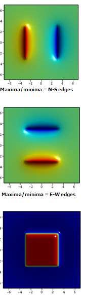
4 Flat Earth vs. Spherical calculations 4
5 Flat Earth vs. Spherical calculations 5

6 Flat Earth vs. Spherical calculations Uieda & Braitenberg 2015 Tesseroids modelling tool: Gravity: available from Magnetics (Baykiev): soon to be released, see slim.dgfi.tum.de
7 Curie temperature isotherm Moho Δρ Crust Lithospheric mantle Asthenospheric mantle

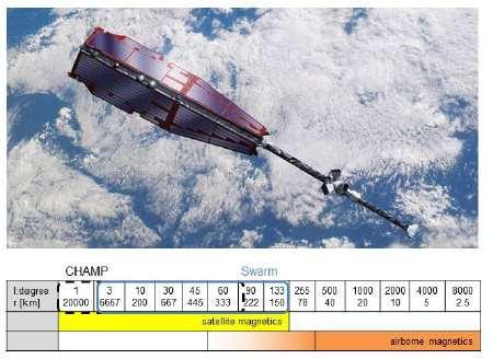
8 The Magnetic Field from Space: Swarm Launched: 22 November 2013
 & lower satellites (app.")

9 Constellation of Satellites 4 years operational phase Low altitude down to 300km (or lower) and pair of satellites for zoom on crustal signal Altitude difference: higher (app. 530km) & lower satellites (app. 450km) 24 hours LT coverage within 7-10 months to avoid seasonal or yearly periods (near polar) Inclination difference: drift between orbital planes towards 9 hours LT Credits: J.E. Rasmussen DNSC launch after 1.5 yr after 3 yrs after 4.5 yrs launch after 4.5 years red (C) 530 km 500 km yellow (A,B) 450 km 300 km

10 Swarm - Mission Aim The Swarm mission will provide the best ever survey of the geomagnetic field and its temporal evolution, in order to gain new insights into the Earth system by improving our understanding of the Earth s interior and physical climate.


11 Improvement of Lithospheric Field Model Before Ørsted... N = 30, resolution: 1330 km... with present satellites Ørsted and CHAMP... N = 60, resolution: 670 km... and with Swarm N = 133, resolution: 300 km Magnetic field of Earth s crust radial component at 10 km altitude

12 Sources of the Earth s Magnetic Field (DTU Space)


13 Radial magnetic component at satellite altitude (DTU Space)
")
14 (DTU Space)
 J (DTU")
15 Magnetic field strength Changes in 6 months (December 2013 to June 2014) J (DTU Space)
 the susceptibility of the oceanic crust was set as 0.")
16 Global modelling A first example CRUST1.0 (Laske et al., 2013) is a 1 o x1 o degree global crustal model comprising several crustal and sedimentary layers. For our model, each 1 o x1 o cell that describes a layer element was converted to a single tesseroid. Following Purucker et. al (2002) the susceptibility of the oceanic crust was set as 0.04 SI, and of the continental crust SI Ambient field IGRF11 (Finlay et al., 2010) Computation grid resolution 2 x2 Computation grid altitude 400 km Eldar Baykiev
 is a 1 o x1 o degree global crustal model comprising several crustal and")

17 Global modelling A first example CRUST1.0 (Laske et al., 2013) is a 1 o x1 o degree global crustal model comprising several crustal and sedimentary layers. For our model, each 1 o x1 o cell that describes a layer element was converted to a single tesseroid. Difference between spherical and ellipsoidal shape of the Earth on data in Swarm orbit Eldar Baykiev

18 Gravity gradients
 Txx")


19 Magnetic gradients (Inclination: 90 ) Txx Txy Txz Tzz Tzx Tzy Tyz Txz Tyy Tyx Tyy Tyz Txx Txy Tzz Susceptibility: 0.02 SI Similar for magnetics, but direction of external field is important..


20 Magnetic gradients (Inclination: 45 ) Txx Txy Txz Tzz Tzx Tzy Tyz Txz Tyy Tyx Tyy Tyz Txx Txy Tzz Susceptibility: 0.02 SI Declination=0

 Txx Txy")


21 Magnetic gradients (Inclination: 0 ) Txx Txy Txz Tzz Tzx Tzy Tyz Txz Tyy Tyx Tyy Tyz Txx Txy Tzz Susceptibility: 0.02 SI Declination=0, anomalies at magnetic equator!


22 Magnetic gradients from MF7 SH=1-120 at surface Br_θ Br_φ Bθ_θ B φ _ θ Stavros Kotsiaros


23 Korhonen et al. 2007
24 Magnetic satellite data Lithospheric signal is small compared to normal (core) field Swarm satellite fly in ~400 and 550 km height Noise/disturbing signal Polar regions are affected by ionospheric turbulences Equatorial jet currents Tesseroids modelling tool available

25 GOCE & Swarm
. Orbit height: 225 to 255 km Grids can be downloaded from http://goce4interior.dgfi.")
26 GOCE -Gravity field and steadystate Ocean Circulation Explorer Mission period 17 March November 2013 Gradiometer; 3 pairs of 3-axis, servocontrolled, capacitive accelerometers (each pair separated by a distance of about 0.5 m). Orbit height: 225 to 255 km Grids can be downloaded from

27 Gravity gradient 255 km height North-north North-east North-radial East-east East-radial Radial-radial
28 Topographic and Bouguer correction Complete Bouguer correction is defined as 1) Gravity effect of Bouguer slab 2) spherical correction 3) Terrain correction
29 Topographic and Bouguer correction Complete Bouguer correction is defined as 1) Gravity effect of Bouguer slab 2) spherical correction 3) Terrain correction h h describes height above reference level or water depth and is different for each station.

 spherical correction 3) Terrain")
30 Topographic and Bouguer correction Complete Bouguer correction is defined as 1) Gravity effect of Bouguer slab 2) spherical correction 3) Terrain correction
31 Topographic and Bouguer correction Complete Bouguer correction is defined as 1) Gravity effect of Bouguer slab 2) spherical correction 3) Terrain correction
32 Topographic and Bouguer correction Bouguer calculation is always possible if only station height is known, can be quickly calculated. Terrain correction requires high-resolution topography for surface data (25 or 50 m for local sources which have highest effect)
33 Topographic and Bouguer correction BUT: NOT WORKING WELL FOR GRADIENTS (Slab of constant thickness has not effect on gradients, terrain important) =>TOPOGRAPHIC MASS REDUCTION (Computational demanding)
34 Topographic and Bouguer correction For satellites: point of obervation above topography (e.g. 250 km) => no high-resolution topography needed
35 Topographic and Bouguer correction TOPOGRAPHIC MASS REDUCTION (for gravity and gradients) possible
36 Global or local topographic correction? Surface Topo Full effect Topo distant effect (1.5 degree) Wolfgang Szwillus
37 Global or local topographic correction? Surface Topo Full effect Satellite height Topo Full effect Topo distant effect (1.5 degree) Topo distant effect (1.5 degree) Wolfgang Szwillus

38 Global or local topographic correction? Surface Topo Full effect Satellite height Topo Full effect Topo distant effect (1.5 degree) Topo distant effect (1.5 degree) Topo distant effect (5 degree) Wolfgang Szwillus
39 Global or local topographic correction? Far field effect of topography is significant Do we have always to calculate globally? Regional modelling only possible, if using global model as reference model for surrounding? But how to treat uncertainties or which model is best suited: Crust 5.0, Crust2.0, Crust1.0, GEMMA? A simple alternative: Use isostatic reference model


40 Isostasy: A justified assumption? Isostatic anomaly GEMMA crustal thickness Moho => Crust Base lithosphere => Lith. Mantle 42
41 Topographic-isostatic correction for Full effect Distant (1.5 degree) Wolfgang Szwillus
42 Remaining distant RIE as function of correction radius for ground stations 5 degrees might be enough, if you want to avoid long computations or Extend your model by 5 degrees during modelling Wolfgang Szwillus
 Distant (5 degree) Wolfgang Szwillus")
43 Topographic-isostatic correction height Full effect Full effect Distant (1.5 degree) Distant (5 degree) Wolfgang Szwillus
44 Remaining distant RIE as a function of correction radius for satellite stations 5 degrees might be enough?? or Extend your model by 5 degrees during modelling or Maybe gradients are better suited? Wolfgang Szwillus
 Wolfgang")
45 Topographic-isostatic correction for gravity gradients at satellite height Full effect Distant (5 degrees) Wolfgang Szwillus
46 Remaining distant RIE gradient component at satellite height <-Vertical gradient Wolfgang Szwillus


47 Remaining distant RIE gradient component at satellite height NE gradient -> <-Vertical gradient Wolfgang Szwillus
48 Topographic reduction of satellite data Replace Bouguer correction with topographic mass reduction Topographic mass reduction of gravity gradients Satellite height: Low resolution topography (4 min) sufficient Global topographic models with 30s are available (SRTM) 10 km height: Omission error of topographic reduction is challenging Extension radius of 5 degrees is sufficient, but use topography over same area as model definition

49 GEMMA project 51


50 GOCE satellite altitude / Earth s surface satellite altitude is smooth Downward continuation enhances signal power & details


51 Comparison GOCE and EGM2008 EGM2008 GOCO3S EGM2008-GOCO3S Free-air anomaly Free-air anomaly Difference Comparison untill spherical harmonic degree 200


52 Crust 1.0: A test for the Arabian pensinsula The Crust 1.0 model cannot explain the measured gravity gradients Note: Gxz and Gyz are even constant to zero which is in large disagreement to the measurements. Observed From Crust1.0


53 Arabian Peninsula Seismological results Hansen et al Bouguer anomaly (EGM2008) A-A Hansen et al. 2007
 Gravity gradients at orbital")
54 Arabian Peninsula Seismological results Hansen et al Bouguer anomaly (EGM2008) Gravity gradients at orbital height:260 km


55 Moho depth by satellite gravity gradient inversion Inversion Gzz=Full Z 0 =30 km Dr= 350 kg/m 3

56 Hansen et al. 2007


57 Sensitivity to intra-crustal sources: lower crust Observed Modelled Gxx Gxy Gxz Gyy Gyz Gzz


58 Lithospheric sensitivity LAB depth Artemieva & Thybo (2008) Full geoid Artemieva & Thybo (2008) Bouguer anomaly

59 Use of GOCE gravity gradient data for lithospheric modeling and geophysical exploration Data sets from the GOCE mission have two main advantages compared with earlier global gravity models: (1) The GOCE gravity model has higher resolution in the transitional wavelength between earlier satellite and terrestrial gravity data. Only based on GOCE gravity data, it would be feasible to provide a gravity field with 80 km resolution (2) The second and more revolutionary novelty is that GOCE measures gravity gradients. How useful for geophysical research and exploration?
60 Depth sensitivity of GOCE gravity gradients What is the depth extent visible in gravity gradient data? Model signal mostly related to crustal thickness? What is the effect of other sources in crust and mantle? 62
61 Sensitivity of satellite gradients => Vertical components good fit, but not non-vertical components? Sensitivity kernels for spherical gravity gradients Z. Martinec 2013

62 Effect of uncertainties of Moho depth and density contrast Density contrast at Moho can vary with respect to upper crust and lower mantle density Typically a range from 300 to 500 kg/m 3 is applied


63 Effect of Moho depth Moho depth (Grad et al. 2009)
64 Effect of Moho depth uncertainty

65 Effect of density uncertainty


66 Lithospheric model set-up < Moho Lith. mantle Asthenosphere Piece-wise calculations for depth slices through 3D model Thickness of depth slices similar to resolution of other geophysical methods
67 0-2.5 km height

68 2.5-5 km height
69 5-7.5 km height
70 km height
71 10-15 km height
72 15-20 km height
73 20-25 km height
74 25-30 km height
75 30-35 km height
76 35-40 km height
77 40-45 km height
78 45-50 km height


79 Sensitivity analysis on the scale of NE Atlantic We use density contrast of -20 to -40 kg/m 3 at base lithosphere Temperature-dependent upper mantle density 81
80 km depth

81 km depth
82 km depth
83 km depth
84 km depth
85 km depth
86 km depth
87 km depth
88 Lithospheric sensitivity GOCE gravity gradients are sensitive to upper 100 km of the lithosphere low sensitivity to thickness of the lithosphere Not affected by regional trends GOCE gradients can complement seismic tomography Seismic tomography has low resolution from Moho to 100 km depth where GOCE gradients are sensitive True on a larger scale? Yes, if realistic density structure is used Simplification by lateral varying density blocks leads to large errors 90

89 Relative signal km height for Model A
90 Relative signal km height for Model A
91 Relative signal km height for Model A


92 Relative signal km height for model A


93 Relative signal km height for model A I2 I1
94 Gradient data and rotational invariants Gradients are dependent on the orientation of the coordinate system, which may differ from the orientation of random geological features Invariants have the advantage to be independent from the coordinate system and help to delineate the outline of density contrasts. Pedersen and Rasmussen (1990) demonstrated the use of rotational invariants of the gravity tensor: I1: contraction invariant deep sources I2: determinant shallow sources 9 6 These rotational invariants are independent from the orientation of the flight lines and facilitate to detect sources randomly orientated in any coordinate system

95 Example: Bedrock/ice corrected gradients for Antarctica


96 Example from an airborne survey E.g. Model interaction often requires profile modelling How to model out of plane components? Solution: Modelling of invariants!

97 Summary: Lithospheric modelling GOCE gravity models provide the most homogeneous global data set Downward continuation possible, but be aware of omission error Satellite gravity gradients help to validate regional crustal setting Non-vertical tensor components are sensitive to subtle lateral density variations Satellite gradients should be used jointly with gravity data to model the entire lithosphere


98 Comparison to global Vs tomography
99
Geophysik mittels Satellitenbeobachtungen - Von der Struktur zur dynamischen Betrachtung der Erde
 Geophysik mittels Satellitenbeobachtungen - Von der Struktur zur dynamischen Betrachtung der Erde Jörg Ebbing Institut für Geowissenschaften Christian-Albrechts-Universität zu Kiel 102. Sitzung des FKPE
Geomagnetic Field Modeling Lessons learned from Ørsted and CHAMP and prospects for Swarm
 Geomagnetic Field Modeling Lessons learned from Ørsted and CHAMP and prospects for Swarm Nils Olsen RAS Discussion Meeting on Swarm October 9 th 2009 Nils Olsen (DTU Space) Ørsted, CHAMP, and Swarm 1 /
A New Lithospheric Field Model based on CHAMP and Swarm Magnetic Satellite Data
 A New Lithospheric Field Model based on CHAMP and Swarm Magnetic Satellite Data Nils Olsen 1, Dhananjay Ravat 2, Christopher C Finlay 1, Livia K. Kother 1 1 DTU Space, Technical University of Denmark 2
A NEW GLOBAL CRUSTAL MODEL BASED ON GOCE DATA GRIDS
 A NEW GLOBAL CRUSTAL MODEL BASED ON GOCE DATA GRIDS M. Reguzzoni, D. Sampietro DIIAR Politecnico di Milano CRUSTAL MODELS SEISMIC MODEL SEISMIC AND GRAVITY Moho model from Meier et al. 2007; unit [km].
9. Density Structure. The Australian Continent: A Geophysical Synthesis Density Structure
 84 The Australian Continent: A Geophysical Synthesis Density Structure 9. Density Structure Although the primary focus for the development of the AuSREM model was the creation of 3-D seismic wavespeed
GOCE. Gravity and steady-state Ocean Circulation Explorer
 GOCE Gravity and steady-state Ocean Circulation Explorer Reiner Rummel Astronomical and Physical Geodesy Technische Universität München rummel@bv.tum.de ESA Earth Observation Summerschool ESRIN/Frascati
Geophysical constraints on geodynamic processes at convergent margins: A global perspective
 Geophysical constraints on geodynamic processes at convergent margins: A global perspective Gondwana Research, 2015 Irina Artemieva Hans Thybo Alexey Shulgin Univ. Copenhagen, Denmark Univ. Copenhagen,
ESA s supporting Activities Related to Mass Transport in the Earth System
 ESA s supporting Activities Related to Mass Transport in the Earth System Roger Haagmans Mission Science Division European Space Agency Swarm mission: 3D-Mantle Conductivity (A. Jackson ETH Zürich, DNSC,
scale Three-dimensional Modelling
 Lithospheric-scale scale Three-dimensional Modelling (Application to the EARS and Plateau) Girma Woldetinsae (Geological Survey of Ethiopia) and H.-J. Götze R. Hackney S. Schmidt (Institut für Geowissenschaften
An Equivalent Source Method for Modelling the Lithospheric Magnetic Field Using Satellite and Airborne Magnetic Data
 Downloaded from orbit.dtu.dk on: Oct 03, 2018 An Equivalent Source Method for Modelling the Lithospheric Magnetic Field Using Satellite and Airborne Magnetic Data Kother, Livia Kathleen; D. Hammer, Magnus;
Global Geomagnetic Field Models from DMSP Satellite Magnetic Measurements
 Global Geomagnetic Field Models from DMSP Satellite Magnetic Measurements Patrick Alken Stefan Maus Arnaud Chulliat Manoj Nair Adam Woods National Geophysical Data Center, NOAA, Boulder, CO, USA 9 May
The Earth s time-variable gravity field observed by GOCE
 The Earth s time-variable gravity field observed by GOCE GOCE+ Time-Variations, part of STSE (Theme 4, Innovative Feasibility Studies) J. Bouman, M. Fuchs, C. Haberkorn, V. Lieb, M. Schmidt T. Broerse,
2008 Monitoring Research Review: Ground-Based Nuclear Explosion Monitoring Technologies
 STRUCTURE OF THE KOREAN PENINSULA FROM WAVEFORM TRAVEL-TIME ANALYSIS Roland Gritto 1, Jacob E. Siegel 1, and Winston W. Chan 2 Array Information Technology 1 and Harris Corporation 2 Sponsored by Air Force
Global Tectonics. Kearey, Philip. Table of Contents ISBN-13: Historical perspective. 2. The interior of the Earth.
 Global Tectonics Kearey, Philip ISBN-13: 9781405107778 Table of Contents Preface. Acknowledgments. 1. Historical perspective. 1.1 Continental drift. 1.2 Sea floor spreading and the birth of plate tectonics.
Source Body Migration, an Approximate Inversion Method for Full Tensor Gravity Gradiometer Data
 Source Body Migration, an Approximate Inversion Method for Full Tensor Gravity Gradiometer Data James Brewster, Alan Morgan, and John Mims * Bell Geospace Inc., 400 N. Sam Houston Pkwy E., Ste. 325, Houston,
Earth system. space. planets. atmosphere. ice sheets. ocean. biosphere, technosphere. solid Earth. gravitation on. orbit, spin, tides
 third lecture Three Lectures: One ESA explorer mission GOCE: earth gravity from space Two Signal Processing on a sphere Three Gravity and earth sciences Earth system space sun moon planets gravitation
Total gravitational field is sum of contributions from all masses.
 Gravity force (acceleration) vs potential (energy) acceleration (g) => GM/r 2 Potential => - GM/r G is Newton s gravitational constant 6.67x10⁻¹¹ (S.I. units) you should determine what the S.I. units are
(ii) Observational Geomagnetism. Lecture 5: Spherical harmonic field models
 Observational Geomagnetism. Lecture 5: Spherical harmonic field models") (ii) Observational Geomagnetism Lecture 5: Spherical harmonic field models Lecture 5: Spherical harmonic field models 5.1 Introduction 5.2 How to represent functions on a spherical surface 5.3 Spherical
(ii) Observational Geomagnetism Lecture 5: Spherical harmonic field models Lecture 5: Spherical harmonic field models 5.1 Introduction 5.2 How to represent functions on a spherical surface 5.3 Spherical
Constraints on Shallow Low-Viscosity Earth Layers from Future GOCE Data
 Constraints on Shallow Low-Viscosity Earth Layers from Future GOCE Data Hugo Schotman 1,2, Bert Vermeersen 2, Pieter Visser 2 1 2 3 rd International GOCE User Workshop, ESA Esrin, 7 November 2006 glacial-isostatic
A Mission to Planet Mars Gravity Field Determination
 A Mission to Planet Mars Gravity Field Determination Department for Theoretical Geodesy Graz University of Technology and Space Research Institute Austrian Academy of Sciences Gravity field CHAMP GRACE
GRACE impact in geodesy and geophysics. R. Biancale (GRGS-CNES Toulouse), M. Diament (IPG Paris)
, M. Diament (IPG Paris)") GRACE impact in geodesy and geophysics R. Biancale (GRGS-CNES Toulouse), M. Diament (IPG Paris) Improvement of gravity models Since 2002 the GRACE mission has changed some goals in geodesy. It has become
GRACE impact in geodesy and geophysics R. Biancale (GRGS-CNES Toulouse), M. Diament (IPG Paris) Improvement of gravity models Since 2002 the GRACE mission has changed some goals in geodesy. It has become
EVALUATING GOCE DATA NEAR A MID-OCEAN RIDGE AND POSSIBLE APPLICATION TO CRUSTAL STRUCTURE IN SCANDINAVIA
 EVALUATING GOCE DATA NEAR A MID-OCEAN RIDGE AND POSSIBLE APPLICATION TO CRUSTAL STRUCTURE IN SCANDINAVIA Wouter van der Wal (1), Lin Wang (2,1), Pieter Visser (1), Nico Sneeuw (2), Bert Vermeersen (1)
POLAR GRAVITY FIELDS FROM GOCE AND AIRBORNE GRAVITY
 POLAR GRAVITY FIELDS FROM GOCE AND AIRBORNE GRAVITY Rene Forsberg (1), Arne V Olesen (1), Hasan Yildiz (2), C C Tscherning (3) (1) DTU-Space, Juliane Maries Vej 30, 2100 Copenhagen Ø, Denmark, email rf@space.dtu.dk
First scalar magnetic anomaly map from CHAMP satellite data indicates weak lithospheric field
 GEOPHYSICAL RESEARCH LETTERS, VOL. 29, NO. 14, 10.1029/2001GL013685, 2002 First scalar magnetic anomaly map from CHAMP satellite data indicates weak lithospheric field S. Maus, M. Rother, R. Holme, H.
The thermal and density structure of passive margins
 The thermal and density structure of passive margins Magdalena Scheck-Wenderoth, Yuriy Maystrenko, Julia Autin, Hans Jürgen Götze, Sabine Schmidt, Christian Reichert basins in their plate-tectonic setting
Calibration/validation of GOCE data by terrestrial torsion balance observations
 Calibration/validation of GOCE data by terrestrial torsion balance observations Gy. Tóth 1, J. Ádám 1, L. Földváry 1,4, I.N. Tziavos 2, H. Denker 3 1 Department of Geodesy and Surveying, Budapest University
GOCE EXPLOITATION FOR MOHO MODELING AND APPLICATIONS D. Sampietro
 ci_net 011 workshop GOCE EXPLOITATION FOR MOHO MODELING AND APPLICATION D. ampietro Department of Hydraulic, Environmental, Infrastructure and urveying Engineering The present research has been partially
High-Harmonic Geoid Signatures due to Glacial Isostatic Adjustment, Subduction and Seismic Deformation
 High-Harmonic Geoid Signatures due to Glacial Isostatic Adjustment, Subduction and Seismic Deformation L.L.A. Vermeersen (1), H. Schotman (1), M.-W. Jansen (1), R. Riva (1) and R. Sabadini (2) (1) DEOS,
Geophysics Physics of the Earth
 Geophysics 210 - Physics of the Earth Final exam Section GEOPH 210 Lecture A01 Instructor Dr. Martyn Unsworth Date Friday December 12 th 2008 Time allowed 9:00 a.m. noon Total = 104 points Please attempt
FORWARD MODELING OF THE GEOID ANOMALY USING SPHERICAL HARMONICS: APPLICATIONS IN THE SIERRA NEVADA. Alissa C Scire
 FORWARD MODELING OF THE GEOID ANOMALY USING SPHERICAL HARMONICS: APPLICATIONS IN THE SIERRA NEVADA by Alissa C Scire A Prepublication Manuscript Submitted to the Faculty of the DEPARTMENT OF GEOSCIENCES
ENVI.2030L - Plate Tectonics - Geomagnetism, Earthquakes, and Gravity
 I. Geomagnetism Name ENVI.2030L - Plate Tectonics - Geomagnetism, Earthquakes, and Gravity The earth's magnetic field can be viewed as a simple bar magnet located near the center of the earth and inclined
The Gulf of Mexico - From Various Vantage Points John E. Bain, Kenton J. Hamilton
 The Gulf of Mexico - From Various Vantage Points John E. Bain, Kenton J. Hamilton Oftentimes in exploration geophysics we tend to focus on specific near-term exploration prospects, as dictated by the current
GRAVITY AND ISOSTASY
 GRAVITY AND ISOSTASY Gravity The Geoid is the oblate spheroid -- the sea level surface over the entire Earth's surface Physically, the Geoid is an equipotential surface for gravity (i.e. the surface for
Isostacy: Compensation of Topography and Isostatic Geoid Anomalies
 Isostacy: Compensation of Topography and Isostatic Geoid Anomalies November 3, 2016 1 Isostacy One of the major goals of interpreting planetary gravity fields is to understand how topography positive (
New satellite mission for improving the Terrestrial Reference Frame: means and impacts
 Fourth Swarm science meeting and geodetic missions workshop ESA, 20-24 March 2017, Banff, Alberta, Canada New satellite mission for improving the Terrestrial Reference Frame: means and impacts Richard
Chapter 4 Multipole model of the Earth's magnetic field
 Chapter 4 Multipole model of the Earth's magnetic field 1 Previously A measurement of the geomagnetic field at any given point and time consists of a superposition of fields from different sources: Internal
Geotherms. Reading: Fowler Ch 7. Equilibrium geotherms One layer model
 Geotherms Reading: Fowler Ch 7 Equilibrium geotherms One layer model (a) Standard model: k = 2.5 W m -1 C -1 A = 1.25 x 10⁻⁶ W m -3 Q moho = 21 x 10-3 W m -2 shallow T-gradient: 30 C km -1 deep T-gradient:
ESA s Juice: Mission Summary and Fact Sheet
 ESA s Juice: Mission Summary and Fact Sheet JUICE - JUpiter ICy moons Explorer - is the first large-class mission in ESA's Cosmic Vision 2015-2025 programme. Planned for launch in 2022 and arrival at Jupiter
OZ SEEBASE TM. Datasets. Digital Elevation Model
 Digital Elevation Model 10 Digital Elevation Models (DEM s) often show the youngest structures, and any active geological structures. They are widely used for neotectonic analysis. The composition of eroding
Gravity data reduction
 Gravity data reduction REDUCTION: raw data à gravity anomaly data Temporal corrections tides and instrument drift Spatial corrections latitude and elevation GRS67 = gravity variation with latitude at sea
5. Gravity. 5.1 Geoid Variations. The Australian Continent: A Geophysical Synthesis Gravity
 34 The Australian Continent: A Geophysical Synthesis Gravity 5. Gravity Gravity data map subtle changes in the Earth s gravitational field caused by variations in the density of the underlying materials.
The southern edge of cratonic North America: Evidence from new satellite magnetometer observations ORS 1-1
 The southern edge of cratonic North America: Evidence from new satellite magnetometer observations ORS 1-1 Michael Purucker, Benoit Langlais, Nils Olsen, Gauthier Hulot, Mioara Mandea To cite this version:
 http://foundation.aapg.org/students/undergraduate/weeks.cfm Tim Carr - West Virginia University 3 Potential Fields Indirect Visualization Density and Magnetization Gravity and Magnetic Exploration Locate
Icelandic Lithosphere & Upper Mantle Structure. Natalia Solomatova
 Icelandic Lithosphere & Upper Mantle Structure Natalia Solomatova Location of Iceland maps.google.com Lithosphere Thickness Anomalously thick lithosphere beneath Greenland and Baltic shield may be due
New advances in geomagnetic field modeling
 New advances in geomagnetic field modeling Patrick Alken, Arnaud Chulliat, Manoj Nair, Brian Meyer, Rick Saltus, Adam Woods, Nir Boneh University of Colorado at Boulder, Boulder, CO National Centers for
Magnetic and Gravity Methods for Geothermal Exploration
 Magnetic and Gravity Methods for Geothermal Exploration Dr. Hendra Grandis Geophysics - ITB method and survey procedure Aero- or ground magnetic (covers a large area) Schlumberger resistivity mapping and
Physics of the Earth
 Physics of the Earth Fourth edition Frank D Stacey CSIRO Exploration and Mining, Brisbane, Australia Paul M Davis Department of Earth and Space Sciences, University of California, Los Angeles, USA CAMBRIDGE
GOCE DATA PRODUCT VERIFICATION IN THE MEDITERRANEAN SEA
 GOCE DATA PRODUCT VERIFICATION IN THE MEDITERRANEAN SEA Juan Jose Martinez Benjamin 1, Yuchan Yi 2, Chungyen Kuo 2, Alexander Braun 3, 2, Yiqun Chen 2, Shin-Chan Han 2, C.K. Shum 2, 3 1 Universitat Politecnica
Constraints on Mantle Structure from Surface Observables
 MYRES I: Heat, Helium & Whole Mantle Convection Constraints on Mantle Structure from Surface Observables Magali Billen University of California, Davis Department of Geology The Goal Use observations of
Euler Deconvolution JAGST Vol. 15(1) 2013
 2013") Euler Deconvolution JAGST Vol. 15(1) 2013 2D-EULER DECONVOLUTION AND FORWARD MODELING OF GRAVITY DATA OF HOMA-HILLS GEOTHERMAL PROSPECT, KENYA A. Odek 1, A. B. Otieno 1, W. J. Ambusso 1 and J. G. Githiri
Euler Deconvolution JAGST Vol. 15(1) 2013 2D-EULER DECONVOLUTION AND FORWARD MODELING OF GRAVITY DATA OF HOMA-HILLS GEOTHERMAL PROSPECT, KENYA A. Odek 1, A. B. Otieno 1, W. J. Ambusso 1 and J. G. Githiri
D. Ravat University of Kentucky Nils Olsen, Chris Finlay, Livia Kother DTU, Technical University of Denmark. With contributions from Mike Purucker
 LCS-1: First lithospheric magnetic field model from CHAMP and Swarm satellites magnetic gradient observations and implications for magnetic anomaly interpretation D. Ravat University of Kentucky Nils Olsen,
Geoid Determination Based on a Combination of Terrestrial and Airborne Gravity Data in South Korea
 Geoid Determination Based on a Combination of Terrestrial and Airborne Gravity Data in South Korea by Hyo Jin Yang Report No. 507 Geodetic Science The Ohio State University Columbus, Ohio 43210 December
Information on internal structure from shape, gravity field and rotation
 Information on internal structure from shape, gravity field and rotation Seismological information is available only for the Earth and in limited amounts for the Moon. Various geodetic data put constraints
1 The satellite altimeter measurement
 1 The satellite altimeter measurement In the ideal case, a satellite altimeter measurement is equal to the instantaneous distance between the satellite s geocenter and the ocean surface. However, an altimeter
SUPPLEMENTARY INFORMATION
 doi:10.1038/nature10566 1 Supplementary Figure 1. Map showing the location of airborne geophysical tracks and seismic stations for the Gamburtsev Subglacial Mountains and adjacent regions of East Antarctica
HIMALAYAN AIRBORNE GRAVITY AND GEOID OF NEPAL
 Mt. Everest HIMALAYAN AIRBORNE GRAVITY AND GEOID OF NEPAL -Niraj Manandhar Head, Geodetic Survey Branch Survey Department, Geodetic Survey Branch Project Background Air Borne Gravity Survey Project was
GOCE based Gravity Field Models Signal and Error Assessment
 GOCE based Gravity Field Models Signal and Error Assessment Th. Gruber, M. Willberg Institute of Astronomical & Physical Geodesy (IAPG) Technical University Munich GOCE Reprocessing Status Expected Results
OPTIMAL FORWARD CALCULATION METHOD OF THE MARUSSI TENSOR DUE TO A GEOLOGIC STRUCTURE AT GOCE HEIGHT
 OPTIMAL FORWARD CALCULATION METHOD OF THE MARUSSI TENSOR DUE TO A GEOLOGIC STRUCTURE AT GOCE HEIGHT Leonardo Uieda (1), Everton P. Bomfim (,3), Carla Braitenberg (3), and Eder Molina () (1) Observatório
The influence of short wavelength variations in viscosity on subduction dynamics
 1 Introduction Deformation within the earth, driven by mantle convection due primarily to cooling and subduction of oceanic lithosphere, is expressed at every length scale in various geophysical observations.
Global geophysics and wave propagation
 Global geophysics and wave propagation Reading: Fowler p76 83 Remote sensing Geophysical methods Seismology Gravity and bathymetry Magnetics Heat flow Seismology: Directly samples the physical properties
4-D Geodynamic Modeling With Data Assimilation: Subduction and Continental Evolution
 4-D Geodynamic Modeling With Data Assimilation: Subduction and Continental Evolution PI: Lijun Liu Department of Geology, University of Illinois at Urbana-Champaign Corresponding author: Lijun Liu, ljliu@illinois.edu
PGM2016: A new geoid model for the. Philippines
 PGM2016: A new geoid model for the Philippines United Nations/Nepal Workshop on the Applications of Global Navigation Satellite Systems Kathmandu, Nepal December 12-16, 2016 Ronaldo Gatchalian, Chief Geodesy
Dynamic Subsidence and Uplift of the Colorado Plateau. Supplementary Material
 GSA DATA REPOSITORY 2010177 Liu and Gurnis Dynamic Subsidence and Uplift of the Colorado Plateau Supplementary Material Lijun Liu and Michael Gurnis Seismological Laboratory California Institute of Technology
Arctic Ocean Mean Sea Surface, Geoid and Gravity from Surface Data, Icesat and GRACE a reference for Cryosat sea-ice mapping
 Arctic Ocean Mean Sea Surface, Geoid and Gravity from Surface Data, Icesat and GRACE a reference for Cryosat sea-ice mapping R. Forsberg and H. Skourup, Geodynamics Dept., DNSC rf@spacecenter.dk Arctic
A BAYESIAN APPROACH TO INVERT GOCE GRAVITY GRADIENTS
 A BAYESIAN APPROACH TO INVERT GOCE GRAVITY GRADIENTS Gwendoline Pajot (1), Michel Diament (1), Marie-Francoise Lequentrec-Lalancette (), and Christel Tiberi (3) (1) Institut de Physique du Globe de Paris,
D DAVID PUBLISHING. Towards a New Geoid Model of Tanzania Using Precise Gravity Data. 1. Introduction. Selassie David Mayunga
 Journal of Environmental Science and Engineering A 5 (2016) 267-276 doi:10.17265/2162-5298/2016.05.005 D DAVID PUBLISHING Towards a New Geoid Model of Tanzania Using Precise Gravity Data Selassie David
Model name GO_CONS_GCF_2_DIR_R5 Producer Method Data period Max. degree Input data Processing strategy
 Model name GO_CONS_GCF_2_DIR_R5 Producer - GFZ German Research Centre for Geosciences Potsdam, Section 1.2 Global Geomonitoring and Gravity Field - Groupe de Recherche de Géodésie Spatiale (GRGS)/CNES,
The use of GOCE gravity satellite data in Geophysical exploration and basin modeling Arabian Peninsula
 The use of GOCE gravity satellite data in Geophysical exploration and basin modeling Arabian Peninsula Rader Abdul Fattah (TNO) S. Meekes (TNO) J. Bouman (DGFI) M. Schmidt (DGFI) J. Ebbing (NGU) Marrakech
Lab 8: Gravity and Isostasy (35 points)
") it's not the most important thing in your life right now. But what is important is gravity. Arnold Schwarzenegger as Colonel John Matrix, Commando (Check out this classic of American cinema!) Lab 8: Gravity
it's not the most important thing in your life right now. But what is important is gravity. Arnold Schwarzenegger as Colonel John Matrix, Commando (Check out this classic of American cinema!) Lab 8: Gravity
The GOCE Geoid in Support to Sea Level Analysis
 The GOCE Geoid in Support to Sea Level Analysis The geoid is a very useful quantity for oceanographers Thomas Gruber Astronomical & Physical Geodesy (IAPG) Technische Universität München 1. Characteristics
Civilization exists by geologic consent, subject to change without notice William Durant
 89.325 Geology for Engineers Plate Tectonics Civilization exists by geologic consent, subject to change without notice William Durant Properties of the Planets Size Density Distance from sun Chemistry
topography half is commonly represented in maps, and how it interacts with
 Topography T. Perron 12.001 We ll spend a large fraction of the second half of the course discussing Earth s surface. Today we ll do two things: First, we ll discuss the ways topography is commonly represented
Numerical solution of the fixed gravimetric BVP on the Earth s surface its possible contribution to the realization of IHRS.
 Numerical solution of the fixed gravimetric BVP on the Earth s surface its possible contribution to the realization of IHRS. Róbert Čunderlík cunderli@svf.stuba.sk Dept. of Mathematics and Descriptive
Introduction to the use of gravity measurements in Ge111A
 Introduction to the use of gravity measurements in Ge111A Background & basic intuition Data reduction Use of the instrument See Reynolds for detailed quantitative discussion What and Why Gravity measures
Last Time. Today s s Agenda. Geophysics. Geophysics. Geophysics. MAS 603: Geological Oceanography. Lecture 21: Geophysics 1: Gravity
 UNIVERSITY OF SOUTH ALABAMA Last Time MAS 603: Geological Oceanography Extinctions Lecture 21: 1: http://www.cartoonstock.com/newscartoons/cartoonists/for/lowres/forn441l.jpg Today s s Agenda Introduction
Chapter 12 Lecture. Earth: An Introduction to Physical Geology. Eleventh Edition. Earth s Interior. Tarbuck and Lutgens Pearson Education, Inc.
 Chapter 12 Lecture Earth: An Introduction to Physical Geology Eleventh Edition Earth s Interior Tarbuck and Lutgens Earth s Internal Structure Earth s interior can be divided into three major layers defined
2008 Monitoring Research Review: Ground-Based Nuclear Explosion Monitoring Technologies
 STRUCTURE OF THE KOREAN PENINSULA FROM WAVEFORM TRAVEL-TIME ANALYSIS Roland Gritto 1, Jacob E. Siegel 1, and Winston W. Chan 2 Array Information Technology 1 and Harris Corporation 2 Sponsored by Air Force
IGPP. Departmental Examination
 IGPP Departmental Examination 1994 Departmental Examination, 1994 This is a 4 hour exam with 12 questions. Write on the pages provided, and continue if necessary onto further sheets. Please identify yourself
GOCE Research in Germany: From Sensor Analysis to Earth System Science
 GOCE Research in Germany: From Sensor Analysis to Earth System Science Reiner Rummel, Jakob Flury and Thomas Gruber Institut für Astronomische und Physikalische Geodäsie Technische Universität München
Presented at the FIG Congress 2018, May 6-11, 2018 in Istanbul, Turkey
 Presented at the FIG Congress 2018, May 6-11, 2018 in Istanbul, Turkey A Geoid model of northern Chile from airborne and surface gravity Geographic Description of Chile. Total Surface: 2,006,096 Km 2.
Geophysics Departmental Exam: 2004 Part 1
 2004 Geophysics Departmental Exam: 2004 Part 1 This section is 90 minutes, closed book, and consists of questions designed to test your knowledge of facts and figures in the geosciences. The focus will
Introduction to the use of gravity measurements
 Introduction to the use of gravity measurements Background & basic intuition Data reduction Use of the instrument See Reynolds, Chpt 2, for detailed quantitative discussion What and Why Gravity measures
The Earth s Structure from Travel Times
 from Travel Times Spherically symmetric structure: PREM - Crustal Structure - Upper Mantle structure Phase transitions Anisotropy - Lower Mantle Structure D D - Structure of of the Outer and Inner Core
C5 Magnetic exploration methods data analysis techniques
 C5 Magnetic exploration methods data analysis techniques C5.1 Data processing and corrections After magnetic field data have been collected a number of corrections are applied to simplify the interpretation.
r 2. (5) This agrees of course with the traditional multipole way of writing it: for an axial point dipole at the coordinate origin
 This agrees of course with the traditional multipole way of writing it: for an axial point dipole at the coordinate origin") 1. A Digression on Dipoles From the perspective of potential theory, the dipole represents the point source obtained by allowing two point charges of opposite sign to approach each other, in such a way
1. A Digression on Dipoles From the perspective of potential theory, the dipole represents the point source obtained by allowing two point charges of opposite sign to approach each other, in such a way
Airborne gravity gradiometer surveying of petroleum systems under Lake Tanganyika, Tanzania
 Airborne gravity gradiometer surveying of petroleum systems under Lake Tanganyika, Tanzania D. Roberts Beach Energy P. Roy Chowdhury CGG S. J. Lowe CGG A. N. Christensen CGG Outline Introduction Geology
(b) What is the amplitude at the altitude of a satellite of 400 km?
 What is the amplitude at the altitude of a satellite of 400 km?") Practice final quiz 2015 Geodynamics 2015 1 a) Complete the following table. parameter symbol units temperature T C or K thermal conductivity heat capacity density coefficient of thermal expansion volumetric)
Practice final quiz 2015 Geodynamics 2015 1 a) Complete the following table. parameter symbol units temperature T C or K thermal conductivity heat capacity density coefficient of thermal expansion volumetric)
Last week we obtained a general solution: 1 cos αdv
 GRAVITY II Surface Gravity Anomalies Due to Buried Bodies Simple analytical solution may be derived for bodies with uniform density contrast simple shape, such as: Sphere Horizontal/vertical cylinders
Swarm Satellite Constellation Application and Research Facility: Status and Plans
 Swarm Satellite Constellation Application and Research Facility: Status and Plans Alan W P Thomson 3 NERC All rights reserved Manchester NAM-MIST 27 th March 2012 and Patrick Alken 2,8, Ciaran Beggan 3,
About the Generation of global Gravity Field Models from Satellite and Surface data
 About the Generation of global Gravity Field Models from Satellite and Surface data Christoph Förste Helmholtz Zentrum Potsdam Deutsches GeoForschungsZentrum GFZ Potsdam, Germany (foer@gfz potsdam.de)
The Structure of the Earth and Plate Tectonics
 The Structure of the Earth and Plate Tectonics Agree or Disagree? 1. The Earth if made up of 4 different layers. 2. The crust (where we live) can be made of either less dense continental crust or the more
THE GOCE ESTIMATED MOHO BENEATH
 HE GOCE EIMAED MOHO BENEAH HE IBEAN PLAEAU AND HIMALAYA D. ampietro (1), M. Reguoni (1), C. Braitenberg (2), R. Barzaghi (1) 1) DIIAR, Politecnico di Milano, Italy (2) Department of Geosciences, University
B. Loomis, D. Wiese, R. S. Nerem (1) P. L. Bender (2) P. N. A. M. Visser (3)
 P. L. Bender (2) P. N. A. M. Visser (3)") Possible mission architectures for a GRACE follow-on mission including a study on upgraded instrumentation suites, and multiple satellite pairs in moderately-inclined orbits B. Loomis, D. Wiese, R. S.
Possible mission architectures for a GRACE follow-on mission including a study on upgraded instrumentation suites, and multiple satellite pairs in moderately-inclined orbits B. Loomis, D. Wiese, R. S.
MASS TRANSPORT AND MASS DISTRIBUTION IN THE EARTH SYSTEM
 MASS TRANSPORT AND MASS DISTRIBUTION IN THE EARTH SYSTEM Jakob Flury (1) and Reiner Rummel (1) (1) German GOCE Project Bureau Institute for Astronomical and Physical Geodesy Technische Universität München,
Core. Crust. Mesosphere. Asthenosphere. Mantle. Inner core. Lithosphere. Outer core
 Potter Name: Date: Hour: Score: /21 Learning Check 4.1 LT 4.1 Earth s Interior: I can draw and interpret models of the interior of the earth. Draw the following models (put the words in the right order)
Gravity 3. Gravity 3. Gravitational Potential and the Geoid. Chuck Connor, Laura Connor. Potential Fields Geophysics: Week 2.
 Gravitational Potential and the Geoid Chuck Connor, Laura Connor Potential Fields Geophysics: Week 2 Objectives for Week 1 Gravity as a vector Gravitational Potential The Geoid Gravity as a vector We can
The GOCE User Toolbox
 The GOCE User Toolbox Jérôme Benveniste - ESA Earth Observation Science and Applications Department Per Knudsen - Danish National Space Center and the GUT TEAM 37th COSPAR Scientific Assembly 2008, Montreal
Globally covering a-priori regional gravity covariance models
 Globally covering a-priori regional gravity covariance models D. Arabelos, C. C. Tscherning To cite this version: D. Arabelos, C. C. Tscherning. Globally covering a-priori regional gravity covariance models.
Imaging Moho topography beneath the Alps by multdisciplinary seismic tomography
 Imaging Moho topography beneath the Alps by multdisciplinary seismic tomography Edi Kissling ETH Zürich SPP short course February 1+2, 218, Berlin, Germany Alpine Moho map from CSS Moho uncertainty derived
Advances and Challenges in the Development and Deployment of Gravity Gradiometer Systems
 Index Table of contents Advances and Challenges in the Development and Deployment of Gravity Gradiometer Systems D. Difrancesco Lockheed Martin Summary The past few years have witnessed significant advances