New advances in geomagnetic field modeling
|
|
|
- Solomon Warren Young
- 5 years ago
- Views:
Transcription
1 New advances in geomagnetic field modeling Patrick Alken, Arnaud Chulliat, Manoj Nair, Brian Meyer, Rick Saltus, Adam Woods, Nir Boneh University of Colorado at Boulder, Boulder, CO National Centers for Environmental Information, NOAA, Boulder, CO Benny Poedjono Schlumberger Outline Introduction Disturbance field correction (magnetosphere) Disturbance field correction (ionosphere) EMAG2 crustal grid update


2 Introduction Main field Crustal field Disturbance field 2

3 Part 1: Disturbance field from the magnetosphere 3

4 Magnetospheric current systems 4
5 How to model the magnetosphere? Model the average behavior of the various magnetospheric sources, and then modulate this with real-time indices such as Dst (derived from ground observatories) Solar wind data (ACE/DISCOVR) F10.7 (solar flux) Modeling approach from Maus and Lühr, GJI, 162,
 launched Feb 2015 Purpose: provide early warning of geomagnetic storms here on Earth 15-60 minute warning time DSCOVR measures solar wind with a cadence 120 times")
6 Solar forecasting: Migration from ACE to DSCOVR ACE (Advanced Composition Explorer) launched Aug 1997 Quality of ACE data quickly degrading due to aging instruments and the space environment DSCOVR (Deep Space Climate Observatory) launched Feb 2015 Purpose: provide early warning of geomagnetic storms here on Earth minute warning time DSCOVR measures solar wind with a cadence 120 times faster than ACE 6

7 Migration from ACE to DSCOVR, cont d 7


8 Real-time prediction of magnetospheric fields Magnetic storm on (peak Dst -194 nt) 8


9 Part 2: Disturbance field from the ionosphere ~80 nt variations nt variations 9


10 Modeling the Sq current system Swarm mission allows measuring ionospheric currents simultaneously at different longitudes This has resulted in a climatological model of the Sq currents, called DIFI Chulliat et al, EPS,
11 The DIFI model DIFI (Dedicated Ionospheric Field Inversion) Derived from over 2 years of Swarm A, B, C and ground observatory data Includes effects of induced currents in the Earth (30% of observed field at surface) Driven by solar flux intensity data 11
12 Honolulu observatory storm measurements 12

13 Observed magnetic field at drill bit B main B Int Bcrust B observed B observed B Int Bext Image courtesy Schlumberger 13
14 MWD Calibration: Brazil MWD with HDGM - Fixed reference MWD with HDGM-RT+DIFI - Variable reference - Better fit Data provided by Schlumberger 14

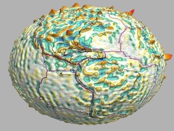
15 Part 3: EMAG2 crustal grid update 15

16 Where does the data come from? Primary source of data comes from marine and airborne tracklines Over 100 institutions Over 50 years 3255 surveys 75.9 million data points 10.5 million miles Precompiled grids over continental areas Provided by Governments, Industry, and Academia 16
17 Send us your data! More data will enable a more detailed grid and more accurate crustal field models NOAA can offer long-term archival Data can be flagged as private/proprietary (not for public download); we currently archive proprietary data Even decimated / lower-resolution datasets would be useful Contact us at geomag.models@noaa.gov 17


18 What has changed? 657 individual surveys 50.6 million data points 2.5 million miles No more model-driven data Represents greater complexity in oceanic regions Grids produced at sea level and at 4km altitude Version 3 Version 2 18
19 Summary Magnetospheric disturbance field modeling Real-time modeling capability Driven by USGS operational Dst index and DSCOVR satellite solar wind data Available to public at geomag.colorado.edu Manual and programmatic access Ionospheric disturbance field modeling Developing real-time modeling of Sq currents Transitioning from research to operations EMAG2_V3 crustal grid update Added 50 million new data measurements into a new crustal grid compilation Will enable next generation, higher resolution crustal field models Please send us data! 19
20 Introduction Geomagnetic main field Generated by convection in Earth s core 95% of observed strength at Earth s surface Slow changes due to secular variation Accurate models with data from observatories and satellites External (disturbance) field Generated from electric currents in Earth s magnetosphere and ionosphere Significant effects near Earth s surface at all latitudes Can change rapidly during storm conditions Data from satellites and observatories Crustal field Generated from magnetized rocks in Earth s crust Significant localized effects near Earth s surface Data from satellites, marine and aeromagnetic surveys 20
 Data discarded if Kp>6o, anomaly > 1000nT,")
21 Processing trackline data Tiles created to be relatively homogeneous data density Remove first order trend from tracklines Add first order trend from MF7 Quality Control during data ingest Scalar Anomaly Calculation df = F_obs F_core - Ds Assign data to tile database Data Leveled to MF7 Airborne Data downward continued Data Selection (F, date/time) Data discarded if Kp>6o, anomaly > 1000nT, gradient > 100nT/km Gridded using krigging algorithm. Remove data collected during storms, and spikes Incorporate data into final grid Much of the data processing is automated, allowing for easy addition of new datasets 21
 Boolean Additions of")
22 Processing precompiled grid data Continental Tiles assigned 1-38 Marine Tiles assigned Highest energy grids given priority Fill grid space for effective fourier filtering Remove long wavelength component Use satellite model MF7 for latest long wavelength observation Final Regional grids from EMAG_V1 processing Merge regional grids by continent (MF7 backing) Boolean Additions of EMAG2_v1 and MF7 to fill grid space New Grids 300km High Pass Filter Reintroduce long wavelength (MF7) Mask to original extent 22


23 EMAG2_V3 Highlights Japan and NW Pacific Alaska and NE Pacific Shackleton Fracture Zone Chicxulub and Scotia Plate 23

24 Magnetospheric model: Real-time Maps Calculator will show real-time maps of the declination, dip and total field Total field at the Earth surface for a magnetic storm in October
Global Geomagnetic Field Models from DMSP Satellite Magnetic Measurements
 Global Geomagnetic Field Models from DMSP Satellite Magnetic Measurements Patrick Alken Stefan Maus Arnaud Chulliat Manoj Nair Adam Woods National Geophysical Data Center, NOAA, Boulder, CO, USA 9 May
The NGDC/USGS Real-time Magnetospheric Disturbance Field Calculator
 The NGDC/USGS Real-time Magnetospheric Disturbance Field Calculator Contributions to the geomagnetic disturbance field Description of the magnetospheric model Validation against observatory measurements
Improved Geomagnetic Referencing in the Arctic Environment
 SPE-166850 Improved Geomagnetic Referencing in the Arctic Environment Benny Poedjono and Nathan Beck, SPE, Schlumberger; Andrew Buchanan and Luca Borri, Eni Petroleum Co.; Stefan Maus, SPE, Magnetic Variation
GE SPACE. Geomagnetic Earth Observation from SPAce
 GE SPACE Geomagnetic Earth Observation from SPAce Fit to NERC s Science Priorities Understanding the complex interactions and feedbacks within the Earth system over a range of space and time scales Fit
Out-of-Cycle Update. of the US/UK World Magnetic Model for
 Out-of-Cycle Update of the US/UK World Magnetic Model for 2015-2020 Arnaud Chulliat Patrick Alken Manoj Nair Adam Woods Brian Meyer Robert Redmon NOAA National Centers for Environmental Information 325
Magnetic field nomenclature
 Magnetic field nomenclature Declination trend angle between horizontal projection of F and true North Inclination plunge angle between horizontal and F Magnetic equator location on surface where field
Geomagnetic Referencing Techniques as Vital Directional Reference in Hydrocarbon Drilling
 Geomagnetic Referencing Techniques as Vital Directional Reference in Hydrocarbon Drilling Elvis Onovughe Department of Earth Sciences Federal University of Petroleum Resources Effurun, Delta State, Nigeria.
First scalar magnetic anomaly map from CHAMP satellite data indicates weak lithospheric field
 GEOPHYSICAL RESEARCH LETTERS, VOL. 29, NO. 14, 10.1029/2001GL013685, 2002 First scalar magnetic anomaly map from CHAMP satellite data indicates weak lithospheric field S. Maus, M. Rother, R. Holme, H.
Using This Flip Chart
 Using This Flip Chart Solar storms can cause fluctuations in the magnetosphere called magnetic storms. These magnetic storms have disabled satellites and burned out transformers shutting down power grids.
Systematic and Random Contributions to the Disturbance Field (IFR 2)
") Systematic and Random Contributions to the Disturbance Field (IFR 2) Objectives of the study: Quantify systematic disturbance field errors Propose missing coefficients needed for QC Analysis of global
Systematic and Random Contributions to the Disturbance Field (IFR 2) Objectives of the study: Quantify systematic disturbance field errors Propose missing coefficients needed for QC Analysis of global
Geomagnetic Disturbances (GMDs) History and Prediction
 History and Prediction") Geomagnetic Disturbances (GMDs) History and Prediction J. Patrick Donohoe, Ph.D., P.E. Dept. of Electrical and Computer Engineering Mississippi State University Box 9571 Miss. State, MS 39762 donohoe@ece.msstate.edu
Geomagnetic Disturbances (GMDs) History and Prediction J. Patrick Donohoe, Ph.D., P.E. Dept. of Electrical and Computer Engineering Mississippi State University Box 9571 Miss. State, MS 39762 donohoe@ece.msstate.edu
A New Lithospheric Field Model based on CHAMP and Swarm Magnetic Satellite Data
 A New Lithospheric Field Model based on CHAMP and Swarm Magnetic Satellite Data Nils Olsen 1, Dhananjay Ravat 2, Christopher C Finlay 1, Livia K. Kother 1 1 DTU Space, Technical University of Denmark 2
CHAPTER 2 DATA. 2.1 Data Used
 CHAPTER DATA For the analysis, it is required to use geomagnetic indices, which are representatives of geomagnetic activity, and Interplanetary Magnetic Field (IMF) data in addition to f F,which is used
Chapter 4 Multipole model of the Earth's magnetic field
 Chapter 4 Multipole model of the Earth's magnetic field 1 Previously A measurement of the geomagnetic field at any given point and time consists of a superposition of fields from different sources: Internal
Geomagnetic Field Modeling Lessons learned from Ørsted and CHAMP and prospects for Swarm
 Geomagnetic Field Modeling Lessons learned from Ørsted and CHAMP and prospects for Swarm Nils Olsen RAS Discussion Meeting on Swarm October 9 th 2009 Nils Olsen (DTU Space) Ørsted, CHAMP, and Swarm 1 /
Tracking Solar Eruptions to Their Impact on Earth Carl Luetzelschwab K9LA September 2016 Bonus
 Tracking Solar Eruptions to Their Impact on Earth Carl Luetzelschwab K9LA September 2016 Bonus In June 2015, the Sun emitted several M-Class flares over a 2-day period. These flares were concurrent with
Space Weather Awareness in the Arctic. Torsten Neubert Head of Section for Solar System Physics
 Space Weather Awareness in the Arctic Torsten Neubert Head of Section for Solar System Physics Technology in the Arctic There is significant potential Resources Tourism helped by receding ocean ice There
(ii) Observational Geomagnetism. Lecture 5: Spherical harmonic field models
 Observational Geomagnetism. Lecture 5: Spherical harmonic field models") (ii) Observational Geomagnetism Lecture 5: Spherical harmonic field models Lecture 5: Spherical harmonic field models 5.1 Introduction 5.2 How to represent functions on a spherical surface 5.3 Spherical
(ii) Observational Geomagnetism Lecture 5: Spherical harmonic field models Lecture 5: Spherical harmonic field models 5.1 Introduction 5.2 How to represent functions on a spherical surface 5.3 Spherical
External Magnetic Field Variations and Aeromagnetic Surveys Experiences, Problems, Potential Solutions
 External Magnetic Field Variations and Aeromagnetic Surveys Experiences, Problems, Potential Solutions Jurgen Watermann Hans Gleisner & Thorkild Rasmussen chercheur associé, Le STUDIUM hosted by LPCE/CNRS
G 3. AN ELECTRONIC JOURNAL OF THE EARTH SCIENCES Published by AGU and the Geochemical Society
 Geosystems G 3 AN ELECTRONIC JOURNAL OF THE EARTH SCIENCES Published by AGU and the Geochemical Society Technical Brief Volume 9, Number 7 25 July 2008 Q07021, doi: ISSN: 1525-2027 Click Here for Full
Swarm Satellite Constellation Application and Research Facility: Status and Plans
 Swarm Satellite Constellation Application and Research Facility: Status and Plans Alan W P Thomson 3 NERC All rights reserved Manchester NAM-MIST 27 th March 2012 and Patrick Alken 2,8, Ciaran Beggan 3,
Chapter 7 Earth Pearson Education, Inc.
 Chapter 7 Earth Units of Chapter 7 7.1 Overall Structure of Planet Earth 7.2 Earth s Atmosphere Why Is the Sky Blue? The Greenhouse Effect and Global Warming 7.3 Earth s Interior Radioactive Dating Units
The Equatorial Ionosphere: A Tutorial
 The Equatorial Ionosphere: A Tutorial Bela G. Fejer Center for Atmospheric and Space Science Utah State University Logan, Utah CEDAR Meeting Seattle, WA June 2015 The Equatorial Ionosphere Outline Introduction
An Equivalent Source Method for Modelling the Lithospheric Magnetic Field Using Satellite and Airborne Magnetic Data
 Downloaded from orbit.dtu.dk on: Oct 03, 2018 An Equivalent Source Method for Modelling the Lithospheric Magnetic Field Using Satellite and Airborne Magnetic Data Kother, Livia Kathleen; D. Hammer, Magnus;
NICT SPACE WEATHER ACTIVITIES
 Prepared by NICT Agenda Item: 3 Discussed in Ad-Hoc Meeting on Space Weather NICT SPACE WEATHER ACTIVITIES Tsutomu Nagatsuma Space Weather and Environment Informatics Laboratory, Applied Electromagnetic
Geomagnetism. The Earth s Magnetic field. Magnetization of rocks. The Earth s magnetic record. Proof of continental drift.
 Geomagnetism The Earth s Magnetic field. The Earth s magnetic record Magnetization of rocks C Gary A. Glatzmaier University of California, Santa Cruz Proof of continental drift Magnetism Magnetic Force
NOAA Space Weather Prediction Center Data and Services. Terry Onsager and Howard Singer NOAA Space Weather Prediction Center
 NOAA Space Weather Prediction Center Data and Services Terry Onsager and Howard Singer NOAA Space Weather Prediction Center Terry.Onsager@noaa.gov Customer Subscriptions to Space Weather Services Frequent
BIRA-IASB, 30th October 2006
 Satellite Anomalies and Launch Failures: Space Weather Connection by Natalia Romanova (runatka@mail.ru) Belgian Institute for Space Aeronomy Institute of the Physics of the Earth, Moscow, Russia BIRA-IASB,
Mars Atmosphere and Volatile Evolution Mission (MAVEN) Status of the MAVEN Mission at Mars 18 May 2018
 Status of the MAVEN Mission at Mars 18 May 2018") Mars Atmosphere and Volatile Evolution Mission (MAVEN) Status of the MAVEN Mission at Mars 18 May 2018 Bruce Jakosky Laboratory for Atmospheric and Space Physics University of Colorado at Boulder USA MAVEN
Mars Atmosphere and Volatile Evolution Mission (MAVEN) Status of the MAVEN Mission at Mars 18 May 2018 Bruce Jakosky Laboratory for Atmospheric and Space Physics University of Colorado at Boulder USA MAVEN
Image Services Providing Access to Scientific Data at NOAA/NCEI
 Image Services Providing Access to Scientific Data at NOAA/NCEI Jesse Varner Cooperative Institute for Research in Environmental Sciences (CIRES), University of Colorado John Cartwright NOAA National Centers
Thermospheric Winds. Astrid Maute. High Altitude Observatory (HAO) National Center for Atmospheric Science (NCAR) Boulder CO, USA
 National Center for Atmospheric Science (NCAR) Boulder CO, USA") Thermospheric Winds Astrid Maute High Altitude Observatory (HAO) National Center for Atmospheric Science (NCAR) Boulder CO, USA High Altitude Observatory (HAO) National Center for Atmospheric Research
Thermospheric Winds Astrid Maute High Altitude Observatory (HAO) National Center for Atmospheric Science (NCAR) Boulder CO, USA High Altitude Observatory (HAO) National Center for Atmospheric Research
Solar and Interplanetary Disturbances causing Moderate Geomagnetic Storms
 J. Astrophys. Astr. (2008) 29, 263 267 Solar and Interplanetary Disturbances causing Moderate Geomagnetic Storms Santosh Kumar, M. P. Yadav & Amita Raizada Department of P.G. Studies and Research in Physics
IGRF-12 GFZ candidates
 IGRF-12 GFZ candidates V. Lesur 1, M. Rother 1, I. Wardinski 1, R. Schachtschneider 1, M. Hamoudi 2, A. Chambodut 3 October 1, 2014 1 Helmholtz Centre Potsdam, GFZ German Research centre for Geosciences,
The contribution of a Geophysical Data Service: the International Service of Geomagnetic Indices
 The contribution of a Geophysical Data Service: the International Service of Geomagnetic Indices Michel Menvielle 1, 2 1 CNRS/INSU, Université Versailles St-Quentin; LATMOS-IPSL, Guyancourt, France 2 Univ
Wavelet Analysis of CHAMP Flux Gate Magnetometer Data
 Wavelet Analysis of CHAMP Flux Gate Magnetometer Data Georgios Balasis, Stefan Maus, Hermann Lühr and Martin Rother GeoForschungsZentrum Potsdam, Section., Potsdam, Germany gbalasis@gfz-potsdam.de Summary.
Updating the GEBCO_08 Grid with regional compilations and surveys
 Updating the GEBCO_08 Grid with regional compilations and surveys Pauline Weatherall, GEBCO Digital Atlas Manager, British Oceanographic Data Centre (BODC) GEBCO TSCOM/iSCRUM meeting, SIO, October 2011
HYBRID DECADE-MEAN GLOBAL SEA LEVEL WITH MESOSCALE RESOLUTION. University of Hawaii, Honolulu, Hawaii, U.S.A.
 HYBRID DECADE-MEAN GLOBAL SEA LEVEL WITH MESOSCALE RESOLUTION Nikolai A. Maximenko 1 and Pearn P. Niiler 2 1 International Pacific Research Center, School of Ocean and Earth Science and Technology, University
12. The diagram below shows the collision of an oceanic plate and a continental plate.
 Review 1. Base your answer to the following question on the cross section below, which shows the boundary between two lithospheric plates. Point X is a location in the continental lithosphere. The depth
ENVI.2030L - Plate Tectonics - Geomagnetism, Earthquakes, and Gravity
 I. Geomagnetism Name ENVI.2030L - Plate Tectonics - Geomagnetism, Earthquakes, and Gravity The earth's magnetic field can be viewed as a simple bar magnet located near the center of the earth and inclined
Coastal Erosion & Climate Change: PRIDE 2005 Towards an Alaska Wind/Wave Climatology
 Coastal Erosion & Climate Change: PRIDE 2005 Towards an Alaska Wind/Wave Climatology 2 nd PRIDE Workshop August 9-10, 2005 David Atkinson, Int l Arctic Research Center, Univ. Of Alaska-Fairbanks James
Activities of the Japanese Space Weather Forecast Center at Communications Research Laboratory
 J. RADIAT. RES., 43: SUPPL., S53 S57 (2002) Activities of the Japanese Space Weather Forecast Center at Communications Research Laboratory SHINICHI WATARI 1 * and FUMIHIKO TOMITA 1 Space weather / ISES/SEP
Earth s Magnetic Field Differential Rotation between the inner core and the outer core.
 Geology 15 Lecture 7 Schedule: Hazard Update: Review Lecture 6 Activity 2 cont: Plate Boundaries and Their Motions Cover Material/Objectives Plate Tectonics (continued) Earth s Structure Evidence for Continental
Tilts and Obliquities!
 Fran Bagenal! University of Colorado! Tilts and Obliquities! Offset Tilted Dipole Approximation Earth Stanley & Bloxham 2006 Jupiter Saturn B radial @ surface Uranus Neptune Magnetic Potential 3-D harmonics
Chapter 8 Geospace 1
 Chapter 8 Geospace 1 Previously Sources of the Earth's magnetic field. 2 Content Basic concepts The Sun and solar wind Near-Earth space About other planets 3 Basic concepts 4 Plasma The molecules of an
Monthly Geomagnetic Bulletin
 HARTLAND OBSERVATORY Monthly Geomagnetic Bulletin BRISTOL CHANNEL December 2002 02/12/HA Hartland NERC 2002 1. HARTLAND OBSERVATORY MAGNETIC DATA 1.1 Introduction This bulletin is published to meet the
Transmission and Dispatching Operations Manual
 MANUAL 12 Transmission and Dispatching Operations Manual October 2012 4.2.10 Adverse Operating Conditions NYISO Actions The NYISO may perform the following actions under adverse operating conditions: 1.
Continental Margin Geology of Korea : Review and constraints on the opening of the East Sea (Japan Sea)
") Continental Margin Geology of Korea : Review and constraints on the opening of the East Sea (Japan Sea) Han-Joon Kim Marine Satellite & Observation Tech. Korea Ocean Research and Development Institute
Continental Margin Geology of Korea : Review and constraints on the opening of the East Sea (Japan Sea) Han-Joon Kim Marine Satellite & Observation Tech. Korea Ocean Research and Development Institute
Regional Outlook for the Bering-Chukchi-Beaufort Seas Contribution to the 2018 Sea Ice Outlook
 Regional Outlook for the Bering-Chukchi-Beaufort Seas Contribution to the 2018 Sea Ice Outlook 25 July 2018 Matthew Druckenmiller (National Snow and Ice Data Center, Univ. Colorado Boulder) & Hajo Eicken
Practice Questions: Plate Tectonics
 Practice Questions: Plate Tectonics 1. Base your answer to the following question on The block diagram below shows the boundary between two tectonic plates. Which type of plate boundary is shown? A) divergent
Seasonal and longitudinal dependence of equatorialdisturbance vertical plasma drifts
 Utah State University From the SelectedWorks of Bela G. Fejer October 1, 2008 Seasonal and longitudinal dependence of equatorialdisturbance vertical plasma drifts Bela G. Fejer, Utah State University J.
This paper was prepared for presentation at the Unconventional Resources Technology Conference held in San Antonio, Texas, USA, July 2015.
 URTeC: 2173526 Enhanced Wellbore Placement Accuracy Using Geomagnetic In-Field Referencing and Multi-Station Correction Stefan Maus, Magnetic Variation Services, Shawn DeVerse, Surcon. Copyright 2015,
Variations of Ion Drifts in the Ionosphere at Low- and Mid- Latitudes
 Variations of Ion Drifts in the Ionosphere at Low- and Mid- Latitudes Edgardo E. Pacheco Jicamarca Radio Observatory Jul, 2014 Outline Motivation Introduction to Ionospheric Electrodynamics Objectives
We have processed RO data for climate research and for validation of weather data since 1995 as illustrated in Figure 1.
 Real-time Analysis of COSMIC Data Christian Rocken, Doug Hunt, Bill Schreiner University Corporation for Atmospheric Research (UCAR) COSMIC Project Office Boulder, CO Abstract UCAR has analyzed GPS radio
Chapter 8: The Dynamic Planet
 Chapter 8: The Dynamic Planet I. The Pace of Change A. The Geologic Time Scale II. Earth s Structure and Internal Energy A. The Earth s Core B. The Earth s Mantle C. The Earth s Crust III. The Geologic
EUMETSAT Activities Related to Climate
 EUMETSAT Activities Related to Climate Jörg Schulz joerg.schulz@eumetsat.int Slide: 1 What we do USER REQUIREMENTS European National Meteorological Services Operating Agency! European Space Industry Private
Ocean Crustal Magnetization and Magnetic Anomalies
 Ocean Crustal Magnetization and Magnetic Anomalies Anomaly and magnetization basics Lavas as largest magnetic source what controls their magnetization? Do lower crustal layers contribute? Magnetic anomalies
Time Series of Images of the Auroral Substorm
 ESS 7 Lecture 13 October 27, 2010 Substorms Time Series of Images of the Auroral Substorm This set of images in the ultra-violet from the Polar satellite shows changes that occur during an auroral substorm.
The Earth. Part II: Solar System. The Earth. 1a. Interior. A. Interior of Earth. A. The Interior. B. The Surface. C. Atmosphere
 Part II: Solar System The Earth The Earth A. The Interior B. The Surface C. Atmosphere 2 Updated: July 14, 2007 A. Interior of Earth 1. Differentiated Structure 2. Seismography 3. Composition of layers
ESA training. Gravity, magnetics and gradients for mapping and modelling. Jörg Ebbing. Department of Geosciences Kiel University
 ESA training Gravity, magnetics and gradients for mapping and modelling Jörg Ebbing Department of Geosciences Kiel University Contributions from: Eldar Baykiev (Trondheim), Des Fitzgerald (Melbourne),
Geophysical Correction Application in Level 2 CryoSat Data Products
 ESRIN-EOP-GQ / IDEAS IDEAS-VEG-IPF-MEM-1288 Version 2.0 29 July 2014 Geophysical Correction Application in Level 2 CryoSat Data Products TABLE OF CONTENTS 1 INTRODUCTION... 3 1.1 Purpose and Scope... 3
Jinwook Jin-wook Han, jangsuk Han choi, Sukbo Hong, Seokjun Jeong, Changhyu Ko
 Jinwook Jin-wook Han, jangsuk Han choi, Sukbo Hong, Seokjun Jeong, Changhyu Ko KSWC Overview The primary action agency of emergency measure to severe SWx, and the RWC Korea of International Space Environment
Diamondback E&P LLC. Standard Survey Report. Andrews County, Tx UL Tawny Unit 8-12 #3LS OH. Design: OH
 Diamondback E&P LLC Andrews County, Tx 42-003-46363 OH Design: OH Standard Report 21 May, 2015 Report Local Co-ordinate Reference: Well Calculation Method: Minimum Curvature Project Andrews County, Tx
Real time Kp predictions from solar wind data using neural networks
 MS No.: EGS.3-3 First author: Boberg Real time predictions from solar wind data using neural networks Fredrik Boberg, Peter Wintoft, and Henrik Lundstedt Lund Observatory, Box 3, SE- Lund, Sweden Swedish
Subject Classification
 Istituto Nazionale di Geofisica e Vulcanologia earth-prints home page roma library bologna library catania library milano library napoli library palerm Subject Classification Earth-prints organize its
The International Geomagnetic Reference Field. Introduction. Scope of the IGRF. Applications and Availability. Inception and development
 The International Geomagnetic Reference Field Susan Macmillan 1 and Christopher Finlay 2 1 British Geological Survey, Murchison House, West Mains Road, Edinburgh, EH9 3LA, UK 2 Institut für Geophysik,
ALASKA REGION CLIMATE OUTLOOK BRIEFING. December 22, 2017 Rick Thoman National Weather Service Alaska Region
 ALASKA REGION CLIMATE OUTLOOK BRIEFING December 22, 2017 Rick Thoman National Weather Service Alaska Region Today s Outline Feature of the month: Autumn sea ice near Alaska Climate Forecast Basics Climate
An Overview of Atmospheric Analyses and Reanalyses for Climate
 An Overview of Atmospheric Analyses and Reanalyses for Climate Kevin E. Trenberth NCAR Boulder CO Analysis Data Assimilation merges observations & model predictions to provide a superior state estimate.
Preliminary study of multi-year ocean salinity trends with merged SMOS and Aquarius data.
 Preliminary study of multi-year ocean salinity trends with merged SMOS and Aquarius data. Gary Lagerloef and Hsun-Ying Kao Earth & Space Research Seattle, USA Aquarius Status Completed 3-year Prime Mission
Recent and future actions about Space Weather in Austria Manuela Temmer
 Recent and future actions about Space Weather in Austria Manuela Temmer Institute of Physics, University of Graz, Austria U.N. Space Weather Expert group Meeting and Workshop, Vienna, Jan 29 Feb 2, 2017
COMPOSITION and PHYSICAL PROPERTIES GENERAL SUBJECTS. GEODESY and GRAVITY
 COMPOSITION and PHYSICAL PROPERTIES Composition and structure of the continental crust Composition and structure of the core Composition and structure of the mantle Composition and structure of the oceanic
Extreme Rainfall in the Southeast U.S.
 Extreme Rainfall in the Southeast U.S. David F. Zierden Florida State Climatologist Center for Ocean Atmospheric Prediction Studies The Florida State University March 7, 2016 Causes of Extreme Rainfall
NOAA/NGDC candidate models for the 12th generation International Geomagnetic Reference Field
 Alken et al. Earth, Planets and Space (2015) 67:68 DOI 10.1186/s40623-015-0215-1 FULL PAPER Open Access NOAA/NGDC candidate models for the 12th generation International Geomagnetic Reference Field Patrick
El Niño: How it works, how we observe it. William Kessler and the TAO group NOAA / Pacific Marine Environmental Laboratory
 El Niño: How it works, how we observe it William Kessler and the TAO group NOAA / Pacific Marine Environmental Laboratory The normal situation in the tropical Pacific: a coupled ocean-atmosphere system
The National Weather Service: Space Weather Prediction Center Update
 The National Weather Service: Space Weather Prediction Center Update Dr. William M. Lapenta Director, National Centers for Environmental Prediction NOAA/National Weather Service Committee on Solar and
Signatures of Geomagnetic Storms and Coronal Mass Ejections on Electron and Ion Temperatures At Low Latitude Upper Ionosphere
 International Journal of Physics and Applications. ISSN 0974-3103 Volume 7, Number 1 (2015), pp. 43-48 International Research Publication House http://www.irphouse.com Signatures of Geomagnetic Storms
This is Planet Earth / Earth Story. Lecture 5 PLATE TECTONICS Drifting Continents, And Oceans That Open And Close
 This is Planet Earth / Earth Story Lecture 5 PLATE TECTONICS Drifting Continents, And Oceans That Open And Close Earth Structure The Lithosphere: Forms the outermost layer of the Earth. Consists of the
INTERPLANETARY ASPECTS OF SPACE WEATHER
 INTERPLANETARY ASPECTS OF SPACE WEATHER Richard G. Marsden Research & Scientific Support Dept. of ESA, ESTEC, P.O. Box 299, 2200 AG Noordwijk, NL, Email: Richard.Marsden@esa.int ABSTRACT/RESUME Interplanetary
GEONS Geomagnetic Event Observation Network By Students
 GEONS Geomagnetic Event Observation Network By Students Calculating B, and K using ASCII Data By James Bridegum, Emilia Groso, Lindsey Peterson, Merrill Asp, and Lisa Beck Carson High School, Carson City,
Sun Earth Connection Missions
 Sun Earth Connection Missions ACE Advanced Composition Explorer The Earth is constantly bombarded with a stream of accelerated particles arriving not only from the Sun, but also from interstellar and galactic
Equatorial and Low Latitude Scintillation Initiated From Low Altitude Forcing via Hurricanes/Typhoons
 Equatorial and Low Latitude Scintillation Initiated From Low Altitude Forcing via Hurricanes/Typhoons Dr. Rebecca Bishop The Aerospace Corporation PSL/SSAL 30 March 2012 The Aerospace Corporation 2012
Mitsubishi Electric Power Products Inc. and Duquesne Light Co.
 Mitsubishi Electric Power Products Inc. and Duquesne Light Co. Overview on Geomagnetically Induced Current Revision #00 March 2017 Presented by: Elizabeth Cook (DLC) and Wesley Terek (MEPPI) Overview on
Establishment of Abdus Salam Geomagnetic Observatory Sonmiani, Pakistan: Site Selection to INTERMAGNET Certification
 Pakistan Space & Upper Atmosphere Research Commission Establishment of Abdus Salam Geomagnetic Observatory Sonmiani, Pakistan: Site Selection to INTERMAGNET Certification G. Murtaza Space Science Department
Lecture 2. Dipole-Axis-Dependent Coordinate Systems and Near Earth's Magnetic Field
 Lecture 2. Dipole-Axis-Dependent Coordinate Systems and Near Earth's Magnetic Field 2.1. Dipole-Axis-Dependent Coordinate Systems Exercise 2.1. Please read the Appendix 3 in the following textbook Introduction
TCC News 1 No. 29 Summer 2012
 No. 29 Summer 2012 Contents Upgrade of JMA s Supercomputer System Summary of Kosa (Aeolian dust) Events over Japan in 2012 Sea Ice in the Sea of Okhotsk for the 2011/2012 Winter Season BMKG expert visit
Initial Results of Altimetry Assimilation in POP2 Ocean Model
 Initial Results of Altimetry Assimilation in POP2 Ocean Model Svetlana Karol and Alicia R. Karspeck With thanks to the DART Group, CESM Software Development Group, Climate Modeling Development Group POP-DART
Spectral Studies of Ionospheric and Solar Wind Electric Fields: Case Studies and Long-Duration Analysis Using Magnetometer Data
 Spectral Studies of Ionospheric and Solar Wind Electric Fields: Case Studies and Long-Duration Analysis Using Magnetometer Data M. C. Kelley, M. J. Nicolls, and G. Sachdeva Cornell University, Ithaca,
2 Preliminary Results Achieved by the Meridian Project
 Space Science Activities in China cycle peak year ( ), magnetic storm activities increased significantly, the Meridian Project has repeatedly observed the responses of the space environment to solar storms
This page intentionally left blank!
 This page intentionally left blank! Solar-Terrestrial Data Available on the k4msu.com Website The original title was going to be... Is KK4BKD a Spy Using k4msu.com to Send Secret Messages? Or, what else
Condensing Massive Satellite Datasets For Rapid Interactive Analysis
 Condensing Massive Satellite Datasets For Rapid Interactive Analysis Glenn Grant University of Colorado, Boulder With: David Gallaher 1,2, Qin Lv 1, G. Campbell 2, Cathy Fowler 2, Qi Liu 1, Chao Chen 1,
Space Weather and Amateur Radio: Science, Forecasting and Effects. The Aerospace Corporation Dayton Hamvention Antenna Forum 19 May 2017
 Space Weather and Amateur Radio: Science, Forecasting and Effects The Aerospace Corporation Dayton Hamvention Antenna Forum 19 May 2017 What is Space Weather? Essentially Space Weather is: A planet s interaction
POES SEM-2 Observations of Radiation Belt Dynamics and Energetic Electron Precipitation in to the Atmosphere
 POES SEM-2 Observations of Radiation Belt Dynamics and Energetic Electron Precipitation in to the Atmosphere Craig J. Rodger 1, Mark A. Clilverd 2, Janet C. Green 3, and Mai M. Lam 2 1. Physics Department,
Images from: Boston.com
 Images from: Boston.com Ireland in the shadow of a volcano: Understanding the 2010 eruption at Eyjafjallajökull, Iceland. Chris Bean, School of Geological Sciences, UCD. World Quakes and Volcanoes 1960-2010
First European Space Weather Week. Space weather - atmospheres, drag, global change future needs. 29 November-3 December 2004
 First European Space Weather Week Space weather - atmospheres, drag, global change future needs 29 November-3 December 2004 Timescales of important phenomena Weather Climate No single statement of requirement
Bill Murtagh. Overview 7/30/2014. Wed_GS_Murtagh_Solar Storms 1
 SOLAR STORMS AND WHAT THEY MEAN FOR UTILITIES Bill Murtagh Program Coordinator NOAA Space Weather Prediction Center (SWPC) National Weather Service Overview Growing concerns Solar cycles Extreme events
Hindcast Arabian Gulf
 Hindcast Arabian Gulf Image of isobars of atmospheric pressure and hindcast wind- and wave field over the Arabian Gulf during a storm in January 1993. Detailed wave studies are supported by nesting of
Link between Hurricanes and Climate Change: SST
 Link between Hurricanes and Climate Change: SST FRIDAY: PROJECT 2 Proposals due! Bring laptops on weds (at least one per group)! Discuss assessment on Weds. Roger Francois will talk on Friday about the
Improved horizontal wind model HWM07 enables estimation of equatorial ionospheric electric fields from satellite magnetic measurements
 Click Here for Full Article GEOPHYSICAL RESEARCH LETTERS, VOL. 35, L11105, doi:10.1029/2008gl033580, 2008 Improved horizontal wind model HWM07 enables estimation of equatorial ionospheric electric fields
Joule heating and nitric oxide in the thermosphere, 2
 JOURNAL OF GEOPHYSICAL RESEARCH, VOL. 115,, doi:10.1029/2010ja015565, 2010 Joule heating and nitric oxide in the thermosphere, 2 Charles A. Barth 1 Received 14 April 2010; revised 24 June 2010; accepted
Introduction to Weather Analytics & User Guide to ProWxAlerts. August 2017 Prepared for:
 Introduction to Weather Analytics & User Guide to ProWxAlerts August 2017 Prepared for: Weather Analytics is a leading data and analytics company based in Washington, DC and Dover, New Hampshire that offers
HELIOSTAT III - THE SOLAR CHROMOSPHERE
 HELIOSTAT III - THE SOLAR CHROMOSPHERE SYNOPSIS: In this lab you will observe, identify, and sketch features that appear in the solar chromosphere. With luck, you may have the opportunity to watch a solar