Numerical solution of the fixed gravimetric BVP on the Earth s surface its possible contribution to the realization of IHRS.
|
|
|
- Winifred Holmes
- 5 years ago
- Views:
Transcription

1 Numerical solution of the fixed gravimetric BVP on the Earth s surface its possible contribution to the realization of IHRS. Róbert Čunderlík cunderli@svf.stuba.sk Dept. of Mathematics and Descriptive Geometry Faculty of Civil Engineering Slovak University of Technology Bratislava, Slovakia SIRGAS-2018: Sessión: Sistemas de altura 9 12 October 2018, Aguascalientes, Mexico
2 Contents Realization of Vertical Reference Systems Fixed gravimetric boundary-value problem (FGBVP) Numerical solution of FGBVP on the triangulated Earth s topography using BEM reconstruction of EGM2008 as a harmonic function - global solution on uniform grid - global solution with local refinements in mountainous areas - local solution in Slovakia reconstruction of GGMPlus in Slovakia local solution using terrestrial gravimetric measurements Possible advantages for the realization of IHRS SIRGAS-2018: Sessión: Sistemas de altura 9 12 October 2018, Aguascalientes, Mexico

3 Realization of Vertical Reference Systems Global approach globally homogenous approach based on precise gravity field modelling W P = U P (h GNSS ) + T P c P = - ( W P - W 0 ) GRACE/GOCE-based satellite-only GGMs fully independent from LVDs low-frequency part obtained very precisely, however overall accuracy affected by the truncation error Continental approach (e.g. EVRF2007) regional approach based on spirit levelling and potential of the height reference surface W 0i NAP c P = c Pi + W 0 W 0i c Pi W 0i W P P 0i gdh
: crucial point: to determine W(P) on the Earth s surface no need to")
4 A concept of the realization of IHRS From presentation of Sánchez at al (IAG-IASPEI-2017, KOBE, JAPAN): crucial point: to determine W(P) on the Earth s surface no need to know 3D position of geoid (W 0 )
 : accuracy of 1 to 2 cm and a spatial resolution of about 100 km")
 Geopotential on DTU13 mean sea surface")
5 Geopotential at points on the Earth s surface GOCE-based satellite-only GGMs low-frequency part obtained very precisely (goal of GOCE) : accuracy of 1 to 2 cm and a spatial resolution of about 100 km affected significantly by stripping noise due to omission errors!!! amplitudes of dm-level (in some places exceeding 1 m) Geopotential on DTU13 mean sea surface evaluated from GO_CONS_GCF_2_DIR_R5 (SH up to d/o 300)
 : accuracy of 1 to 2 cm and a spatial resolution of about 100 km affected significantly")
 inevitable to model the high-frequency part combined GGMs (including RTM) national (quasi)geoid models!")
6 Geopotential at points on the Earth s surface GOCE-based satellite-only GGMs low-frequency part obtained very precisely (goal of GOCE) : accuracy of 1 to 2 cm and a spatial resolution of about 100 km affected significantly by stripping noise due to omission errors!!! (Source: Kreye et al. 2006) inevitable to model the high-frequency part combined GGMs (including RTM) national (quasi)geoid models!!! terrestrial or airborne gravimetric measurements!!!
 = 0 T(x), s(x) = - g(x) T(x) = O ( x")
 = W(x) U(x) s(x) = U(x) / U(x) - the Earth - the Earth s")
 g(x) = g(x) - (x) Precise 3D positioning by")
7 Fixed gravimetric BVP Linearized Fixed Gravimetric BVP exterior BVP for the Laplace equation T (x) = 0 T(x), s(x) = - g(x) T(x) = O ( x -1 ) x ext. x where T(x) = W(x) U(x) s(x) = U(x) / U(x) - the Earth - the Earth s surface Input data surface gravity disturbances (oblique derivative boundary conditions) g(x) = g(x) - (x) Precise 3D positioning by GNSS: globally consistent independent from local vertical datums
8 Direct BEM for the fixed gravimetric BVP Linearized fixed gravimetric BVP T (x) = 0 T(x), s(x) = - g(x) T(x) = O ( x -1 ) x ext. x Direct BEM formulation Boundary Integral Equation: 1 T 2 G n T n p T q p, q d q q G p, q d q where G p, q 1 4 p q fundamental solution of the Laplace equation (as a weighted function)


9 Triangulation of the Earth s surface An example of a local refinement of the global triangulation


10 Triangulation on the Earth s topography detail in Central Andes
11 Reconstruction of EGM2008 on the triangulates Earth s topography Case A Case B Global resolution: deg Global resolution: 0.05 deg nodes nodes Case C Global resolution: deg + local refinement 1: deg + local refinement 2: deg nodes

![05 deg A+LR1+LR2 Nodes 5 760 002 12 960 002 8 818 389 Mean [m 2 s -2 ]](/docs-images/94/120861899/images/12-1.jpg "-1.315-0.939-0.514 Max [m 2 s -2 ] 1.216 0.084 0.")
12 Comparison: BEM - EGM2008 A B C STATISTICS OF RESIDUALS Case A B C Resolution deg 0.05 deg A+LR1+LR2 Nodes Mean [m 2 s -2 ] Max [m 2 s -2 ] Min [m 2 s -2 ] STD [m 2 s -2 ]

13 Comparison in Andes: BEM - EGM2008


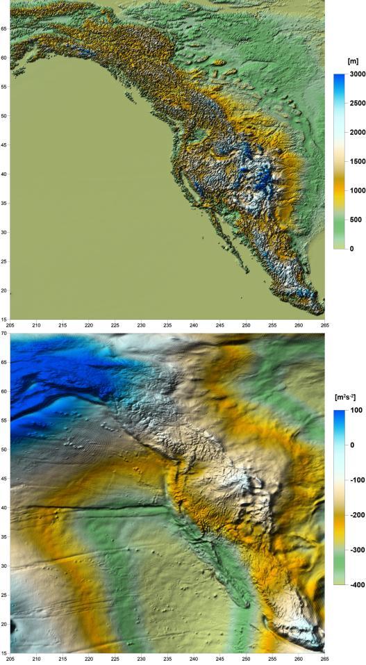
14 Comparison in North America: BEM - EGM2008 A B C


15 Comparison in Himalayas: BEM - EGM2008 A B C

16 Local refinement of triangulation in Himalayas Mt. Everest


17 Local refinement in Slovakia (EU) Global resolution: local refinement 1: local refinement 2: local refinement 3: local refinement 4: local refinement 5: ( 260 m) TOPO


18 Reconstruction of EGM2008 in Slovakia EGM2008 BEM - EGM2008 BEM - EGM2008 STATISTICS OF RESIDUALS Nodes Mean m 2 s -2 Max m 2 s -2 Min m 2 s -2 STD m 2 s -2

 TOPO http://www.geom.")
19 Input surface gravity disturbances EGM2008 (SH up to d/o 2160) GGMplus (EIGEN-6C4 + RTM) TOPO
20 Reconstruction of GGMPlus GGMPlus BEM - GGMplus STATISTICS OF RESIDUALS Nodes Mean m 2 s -2 Max m 2 s -2 Min m 2 s -2 STD m 2 s -2 TOPO
21 Reconstruction of GGMPlus GGMPlus BEM - GGMplus GGMPlus BEM STD: 2.44 cm STD: 2.42 cm GNSS-Levelling test
22 Terrestrial gravimetric mapping in Slovakia more than measurements (collected during the last decades) Digital terrain model TOPO
 about 55% of all nodes in Slovakia replaced modified")
23 Terrestrial gravimetric measurements GGMplus nodes replaced by original measurements: if (dist < 120 m) about 55% of all nodes in Slovakia replaced modified triangulation
24 Original gravimetric data GGMPlus!!! Local extremes exceed 10 mgal!!!
25 Contribution of gravimetric measurements
26 Contribution of gravimetric measurements
 (Pašteka et al. 2014) CBA2G_SK software (Marušiak et al.")
27 Input gravity disturbances generated from CBA Remained GGMplus nodes replaced by generated gravity disturbances about 45% of all nodes in Slovakia Complete Bouguer Anomalies (CBA) (Pašteka et al. 2014) CBA2G_SK software (Marušiak et al. 2015) Geological structures
28 Contribution of terrestrial + generated from CBA [m 2 s -2 ]
??? Open questions?")
?")

29 Correlation with Bouguer anomalies? [m 2 s -2 ] DG (orig GGMplus)??? Open questions??? Complete Bouguer Anomalies How is the impact of the low-frequency part of the GOCE-based GGMs ( 2 cm accuracy)? Can we really detect biases in the terrestrial gravimetric measurements in low frequencies? How does it influence the quasigeoid modelling (e.g. using the R-C-R strategies)?
30 GNSS-Levelling test of combined GGMs in Slovakia EGM-2008 EIGEN-6C4 GGMPlus (SH up to d/o 2160) (SH up to d/o 2160) (EIGEN-6C4 + residual terrain model) STD: 4.0 cm STD: 3.2 cm STD: 2.44 cm at 336 benchmarks provided by GKÚ Bratislava (10 outliers removed) TOPO

31 GNSS-Levelling test of BEM solutions Reconstruced GGMPlus + original gravity data + generated from CBA STD: 2.42 cm STD: 2.40 cm STD: 2.75 cm
32 Possible contribution for realization of IHRS Advantages BEM solution is obtained directly at points on the Earth s surface Realization of IHRS (concept) terrestrial gravimetric measurements can directly represent computational nodes considering their 3D positions there is no need to make any reduction from masses or heights!!! Local BEM solutions can reach cm-level accuracy requires very dense distribution of terrestrial gravimetric data achieved precision is dependent on quality of input data Drawbacks BEM solutions is biased due to an insufficient global discretization this can be overcome by a reconstruction of a known harmonic function (e.g. EGM-2008) on a same computational grid this yields the correction function from the discretization error

33 Conclusions Global approach based on precise gravity field modelling is suitable for a realization of the Vertical Reference Systems (also on continental scale) globally consistent at present, cm-level accuracy can be achieved by a combination of the combined GGMs (e.g. EGM-2008, EIGEN-6C4) with residual terrain model (e.g. GGMPlus), however, precise local (national) quasigeoid modelling can lead to more precise solutions (if terrestrial or airborne gravity data are available) (Remark: quasigeoid is nothing else than the disturbing potential on the Earth s surface rescale to metric units) Fixed gravimteric BVP should be preferred input gravity disturbances are independent from local LVDs (globally consistent) BEM approach allows to determine geopotential on the Earth s surface

34 Muchas gracias por la atención
A Study on Precise Local Gravity Field Modelling
 A Study on Precise Local Gravity Field Modelling R. Čunderlík 1, J. Papčo 2, P. Záhorec 3 cunderli@svf.stuba.sk, juraj.papco@stuba.sk, zahorec@savbb.sk 1 Dept. of Mathematics and Descriptive Geometry,
PGM2016: A new geoid model for the. Philippines
 PGM2016: A new geoid model for the Philippines United Nations/Nepal Workshop on the Applications of Global Navigation Satellite Systems Kathmandu, Nepal December 12-16, 2016 Ronaldo Gatchalian, Chief Geodesy
Global vertical datum unification based on the combination of the fixed gravimetric and the scalar free geodetic boundary value problems
 Global vertical datum unification based on the combination of the fixed gravimetric and the scalar free geodetic boundary value problems Laura Sánchez contribution to the IAG-IC.: Vertical Reference Frames
Evaluation of the Earth Gravity Model EGM2008 in Algeria
 Evaluation of the Earth Gravity Model EGM2008 in Algeria BENAHMED DAHO S. A. National Centre of Space Techniques, Geodetic Laboratory - BP 13 Arzew - 31200 - Algeria. E-mail: d_benahmed@hotmaii.com /Fax:
HIMALAYAN AIRBORNE GRAVITY AND GEOID OF NEPAL
 Mt. Everest HIMALAYAN AIRBORNE GRAVITY AND GEOID OF NEPAL -Niraj Manandhar Head, Geodetic Survey Branch Survey Department, Geodetic Survey Branch Project Background Air Borne Gravity Survey Project was
A two-step point mass method for regional gravity field modeling: a case study over the Auvergne test area
 A two-step point mass method for regional gravity field modeling: a case study over the Auvergne test area - Geodätische Woche 2014 - Session 2 - Schwerefeld und Geoid Miao Lin, Heiner Denker, Jürgen Müller
D DAVID PUBLISHING. Towards a New Geoid Model of Tanzania Using Precise Gravity Data. 1. Introduction. Selassie David Mayunga
 Journal of Environmental Science and Engineering A 5 (2016) 267-276 doi:10.17265/2162-5298/2016.05.005 D DAVID PUBLISHING Towards a New Geoid Model of Tanzania Using Precise Gravity Data Selassie David
Strategy for the Realization of the International Height Reference System (IHRS)
") Deutsches Geodätisches Forschungsinstitut (DGFI-TUM) Technische Universität München Strategy for the Realization of the International Height Reference System (IHRS) Laura Sánchez 1, Johannes Ihde 2, Roland
Deutsches Geodätisches Forschungsinstitut (DGFI-TUM) Technische Universität München Strategy for the Realization of the International Height Reference System (IHRS) Laura Sánchez 1, Johannes Ihde 2, Roland
New gravimetric quasigeoid of Slovakia
 BOLLETTINO DI GEOFISICA TEORICA ED APPLICATA VOL. 40, N. 3-4, pp. 211-217; SEP.-DEC. 1999 New gravimetric quasigeoid of Slovakia M. MOJZEŠ and J. JANÁK Departament of Theoretical Geodesy, Slovak University
A new geoid model for Bhutan. Machiel Bos Rui Fernandes
 A new geoid model for Bhutan Machiel Bos (machiel@segal.ubi.pt) Rui Fernandes (rui@segal.ubi.pt) June 2015 1 Definition of heights June 2015 2 Purpose of a geoid model Orthometric heights are the official
An upwind-based scheme for solving the oblique derivative boundary-value problem related to physical geodesy
 J. Geod. Sci. 2015; 5:180 188 Research Article Open Access Marek Macák*, Róbert Čunderlík, Karol Mikula, and Zuzana Minarechová An upwind-based scheme for solving the oblique derivative boundary-value
Status of the European Gravimetric Quasigeoid
 Status of the European Gravimetric Quasigeoid C. Voigt, H. Denker {voigt,denker}@ife.uni-hannover.de 1 Introduction 2 The European Gravity and Geoid Project (EGGP) 3 Data Sets 4 Quasigeoid Computation
The GOCE Geoid in Support to Sea Level Analysis
 The GOCE Geoid in Support to Sea Level Analysis The geoid is a very useful quantity for oceanographers Thomas Gruber Astronomical & Physical Geodesy (IAPG) Technische Universität München 1. Characteristics
Height System Unification with GOCE
 Height System Unification with GOCE North American Analyses and Main Results M.G. Sideris and E. Rangelova University of Calgary Overview of the UoC contributions Tailored GOCE model Computing MSL at Canadian
Height system unification in Europe
 Height system unification in Europe Axel Rülke, Gunter Liebsch, Martina Sacher, Uwe Schäfer, Uwe Schirmer, Johannes Ihde Federal Agency for Cartography and Geodesy International Symposium on Gravity, Geoid
On Determination of a Regional Vertical Datum by Combination of EGM, Local Gravity and GPS/leveling Data
 On Determination of a Regional Vertical Datum by Combination of EGM, Local Gravity and GPS/leveling Data Pavel NOVÁK, Czech Republic Key words: geodetic heights, orthometric heights, normal heights, geoid,
A new technique to determine geoid and orthometric heights from satellite positioning and geopotential numbers
 J Geod 6 8: 4 1 DOI 1.17/s19-6-57-5 OIGINAL ATICLE L. E. Sjöberg A new technique to determine geoid and orthometric heights from satellite positioning and geopotential numbers eceived: 19 September 5 /
THE SITUATION IN EASTERN EUROPE ABOUT GEOID / QUASIGEOID MODELS DETERMINATION
 THE SITUATION IN EASTERN EUROPE ABOUT GEOID / QUASIGEOID MODELS DETERMINATION Petre Iuliu DRAGOMIR, Professor, PhD Technical University of Civil Engineering Bucharest, Faculty of Geodesy, pdragomir@rdslink.ro
Geoid Determination Based on a Combination of Terrestrial and Airborne Gravity Data in South Korea
 Geoid Determination Based on a Combination of Terrestrial and Airborne Gravity Data in South Korea by Hyo Jin Yang Report No. 507 Geodetic Science The Ohio State University Columbus, Ohio 43210 December
Latest Geoid Determinations for the Republic of Croatia
 Latest Geoid Determinations for the Republic of Croatia T. Bašić *, Ž. Hećimović ** * Faculty of Geodesy, University of Zagreb, HR-10000 Zagreb, Kačićeva 26, Croatia ** Av. M. Držića 76, 10000 Zagreb,
Presented at the FIG Congress 2018, May 6-11, 2018 in Istanbul, Turkey
 Presented at the FIG Congress 2018, May 6-11, 2018 in Istanbul, Turkey A Geoid model of northern Chile from airborne and surface gravity Geographic Description of Chile. Total Surface: 2,006,096 Km 2.
GRACE Gravity Model GGM02
 GRACE Gravity Model GGM02 The GGM02S gravity model was estimated with 363 days (spanning April 2002 through December 2003) of GRACE K-band range-rate, attitude, and accelerometer data. No Kaula constraint,
EPUSP. ( Escola Politécnica da Universidade de São Paulo
 EPUSP Escola Politécnica da Universidade de São Paulo Present and Future of the gravity surveys and geoid model in South America Denizar Blitzkow Ana Cristina Oliveira Cancoro de Matos Gabriel do Nascimento
CENTIMETRE LEVEL OF ACCURACY OF QUASIGEOID MODEL IN POLAND
 CENTIMETRE LEVEL OF ACCURACY OF QUASIGEOID MODEL IN POLAND Jan Krynski Institute of Geodesy and Cartography, Poland krynski@igik.edu.pl Adam Lyszkowicz University of Warmia and Mazury in Olsztyn, Poland
A new degree 2190 (10 km resolution) gravity field model for Antarctica developed from GRACE, GOCE and Bedmap2 data
 gravity field model for Antarctica developed from GRACE, GOCE and Bedmap2 data") Citation: Hirt C., M. Rexer, M. Scheinert, R. Pail, S. Claessens and S. Holmes (2015), A new degree 2190 (10 km resolution) gravity field model for Antarctica developed from GRACE, GOCE and Bedmap2 data.
Citation: Hirt C., M. Rexer, M. Scheinert, R. Pail, S. Claessens and S. Holmes (2015), A new degree 2190 (10 km resolution) gravity field model for Antarctica developed from GRACE, GOCE and Bedmap2 data.
Contributions to Geophysics and Geodesy Vol. 46/3, 2016 ( )
") Contributions to Geophysics and Geodesy Vol. 46/3, 2016 (179 202) An analysis of methods for gravity determination and their utilization for the calculation of geopotential numbers in the Slovak national
Contributions to Geophysics and Geodesy Vol. 46/3, 2016 (179 202) An analysis of methods for gravity determination and their utilization for the calculation of geopotential numbers in the Slovak national
Calibration/validation of GOCE data by terrestrial torsion balance observations
 Calibration/validation of GOCE data by terrestrial torsion balance observations Gy. Tóth 1, J. Ádám 1, L. Földváry 1,4, I.N. Tziavos 2, H. Denker 3 1 Department of Geodesy and Surveying, Budapest University
Activities in South America: Gravity and Geoid Projects
 Activities in South America: Gravity and Geoid Projects Segundo Taller de Grupo de Trabajo I SIRGAS Montevideo - Uruguay May 26 a 30, 2008 Maria Cristina Pacino Universidade de Rosário CGED - IBGE Denizar
National Report of Sweden
 National Report of Sweden NKG geoid WG meeting Jonas Ågren jonas.agren@lm.se Jonas Ågren, 2010-03-09, Masala Summary of Swedish geoid activities Updated GNSS/levelling observations. New gravimetric quasigeoid
Unification of height systems using GNSS-leveling data and global satellite gravity models
 Unification of height systems using GNSS-leveling data and global satellite gravity models R. Barzaghi*, A. Gatti, D. Carrion*, M. Gilardoni*, M. Reguzzoni*, G. Venuti* *DICA, Politecnico di Milano, P.zza
Coastal geoid improvement using airborne gravimetric data in the United Arab Emirates
 International Journal of Physical Sciences Vol. 7(45), pp. 6012-6023, 30 November, 2012 Available online at http://www.academicjournals.org/ijps DOI: 10.5897/IJPS12.413 ISSN 1992-1950 2012 Academic Journals
Splinter meeting at GGHS2016 Wednesday, Sept. 21, 2016 Laura Sánchez
 Working Group on the Strategy for the Realization of the International Height Reference System (IHRS) Splinter meeting at GGHS2016 Wednesday, Sept. 21, 2016 Laura Sánchez -Brainstorming and definition
UCGE Reports Number 20344
 UCGE Reports Number 20344 Department of Geomatics Engineering Geoid Investigations for the New Vertical Datum in Canada (URL: http://www.geomatics.ucalgary.ca/graduatetheses) by Elmas Sinem Ince December
A Preliminary Gravitational Model to Degree 2160
 A Preliminary Gravitational Model to Degree 2160 N.K. Pavlis, S.A. Holmes Raytheon ITSS Corporation, 1616 McCormick Drive, Upper Marlboro, Maryland 20774, USA Nikolaos_Pavlis@raytheon.com Fax: +301-883-4140
The first high-precision gravimetric geoid of Hungary: HGG2013
 Server on Geodesy, Seismology and Environmental Sciences Published Online 2013 (http://airy.ual.es/) The first high-precision gravimetric geoid of Hungary: HGG2013 Abstract V. Corchete Higher Polytechnic
Geoiddetermination -a brief review. Zainal Abidin Md Som Department of Geoinformation FGHT
 Geoiddetermination -a brief review Zainal Abidin Md Som Department of Geoinformation FGHT The geoid Definition of Geoid The one gravityequipotentialsurface of particular interest is that which best approximates
Arctic Ocean Mean Sea Surface, Geoid and Gravity from Surface Data, Icesat and GRACE a reference for Cryosat sea-ice mapping
 Arctic Ocean Mean Sea Surface, Geoid and Gravity from Surface Data, Icesat and GRACE a reference for Cryosat sea-ice mapping R. Forsberg and H. Skourup, Geodynamics Dept., DNSC rf@spacecenter.dk Arctic
Regional Geoid Determination Methods for the Era of Satellite Gravimetry
 Regional Geoid Determination Methods for the Era of Satellite Gravimetry Numerical Investigations Using Synthetic Earth Gravity Models Jonas Ågren Doctoral Dissertation in Geodesy Royal Institute of Technology
Detailed Geoid Model for Africa Final Report
 Detailed Geoid Model for Africa Final Report Hussein A. Abd-Elmotaal Minia University, Faculty of Engineering Civil Engineering Department Egypt abdelmotaal@lycos.com 1. Over View This report summaries
Evaluation and Improvement of the EGG97 Quasigeoid Model for Europe by GPS and Leveling Data
 Evaluation and Improvement of the EGG97 Quasigeoid Model for Europe by GPS and Leveling Data Heiner Denker Institut für Erdmessung, Universität Hannover, Schneiderberg 50, D-30167 Hannover, Germany E-mail:
Fitting Gravimetric Local and Global Quasi-Geoids to GPS/Levelling Data: The Role of Geoid/Quasi-Geoid Variations
 JKAU: Eng. Sci., Vol.20 No.1, pp: 47-59 (2009 A.D. / 1430 A.H.) Fitting Gravimetric Local and Global Quasi-Geoids to GPS/Levelling Data: The Role of Geoid/Quasi-Geoid Variations Gomaa M. Dawod (1, 2) and
Final VRF grids Date: Aug 25, 2011 Author: R. Forsberg, G. Strykowski, O. Andersen
 Final VRF grids Date: Aug 25, 2011 Author: R. Forsberg, G. Strykowski, O. Andersen www.blast-project.eu 1 Authors Name Organisation Rene Forsberg National Space Institute, DTU G. Strykowski National Space
Consideration of a Global Vertical Reference System (GVRS) in the IERS Conventions
 in the IERS Conventions") Consideration of a Global Vertical Reference System (GVRS) in the IERS Conventions Johannes Ihde Federal Agency for Cartography and Geodesy (BKG) Chair of IAG ICP1.2 (2003-2007) Vertical Reference Frames
Consideration of a Global Vertical Reference System (GVRS) in the IERS Conventions Johannes Ihde Federal Agency for Cartography and Geodesy (BKG) Chair of IAG ICP1.2 (2003-2007) Vertical Reference Frames
Geopotential numbers from GPS satellite surveying and disturbing potential model: a case study of Parana, Brazil
 Note: This is the accepted version of the ms 10.1515/JAG.2011.016 available at: http://www.degruyter.com/view/j/jag.2011.5.issue-3-4/jag.2011.016/jag.2011.016.xml Journal of Applied Geodesy Geopotential
The progress of the geoid in south America under GRACE and EGM08 models
 University of São Paulo The progress of the geoid in south America under GRACE and EGM08 models Polytechnic School Brazilian Institute of Geography and Statistics D. Blitzkow (E-mail: dblitzko@usp.br)
The History and Future of Geoid Modelling at UNB
 The History and Future of Geoid Modelling at UNB Robert Kingdon 1, Petr Vaníček and Marcelo Santos 1 Ph. D. Candidate, Department of Geodesy and Geomatics Engineering, University of New Brunswick, Fredericton,
International Gravity Field Service (IGFS)
") IAG-Services: International Gravity Field Service (IGFS) 477 International Gravity Field Service (IGFS) http://www.gravityfield.org Chairman: Renè Forsberg (Denmark, 2011-2013) - Riccardo Barzaghi (Italy,
IAG-Services: International Gravity Field Service (IGFS) 477 International Gravity Field Service (IGFS) http://www.gravityfield.org Chairman: Renè Forsberg (Denmark, 2011-2013) - Riccardo Barzaghi (Italy,
Evaluation of EGM 2008 and EIGEN-6C3stat by means of data from GNSS/leveling
 Evaluation of EGM 2008 and EIGEN-6C3stat by means of data from GNSS/leveling J. Kostelecký 1, J. Klokočník 2, A. Bezděk 2* 1 Research Institute of Geodesy, Topography and Cartography (VÚGTK), CZ 250 66
GRACE impact in geodesy and geophysics. R. Biancale (GRGS-CNES Toulouse), M. Diament (IPG Paris)
, M. Diament (IPG Paris)") GRACE impact in geodesy and geophysics R. Biancale (GRGS-CNES Toulouse), M. Diament (IPG Paris) Improvement of gravity models Since 2002 the GRACE mission has changed some goals in geodesy. It has become
GRACE impact in geodesy and geophysics R. Biancale (GRGS-CNES Toulouse), M. Diament (IPG Paris) Improvement of gravity models Since 2002 the GRACE mission has changed some goals in geodesy. It has become
Towards The Modernization Of Indian Vertical Datum
 Towards The Modernization Of Indian Vertical Datum Dr. S. K. SINGH KEYWORDS:- geo-potential value; tide gauge; vertical datum; GNSS/ Levelling BMs; Global geo-potential Model. SUMMARY:- A National vertical
Height systems. Rudi Gens Alaska Satellite Facility
 Rudi Gens Alaska Satellite Facility Outline Why bother about height systems? Relevant terms Coordinate systems Reference surfaces Geopotential number 2 Why bother about height systems? give a meaning to
A new best estimate for the conventional value W 0
 - Final Report of the G on Vertical Datum tandardization - L. ánchez Deutsches Geodätisches Forschungsinstitut, Technische Universität München DGFI-TUM, Germany R. Čunderlí, K. Miula, Z. Minarechová Department
Precision geoid determination by spherical FFT in and around the Korean peninsula
 Earth Planets Space, 51, 13 18, 1999 Precision geoid determination by spherical FFT in and around the Korean peninsula Hong-Sic Yun Department of Civil Engineering, Sungkyunkwan University, Korea (Received
Manuscript of the article: spectral components of the gravity field derived from various terrestrial data sets.
 Manuscript of the article: spectral components of the gravity field derived from various terrestrial data sets. Appeared in: Acta Geodaetica et Geophysica, 2014, Volume 49, Issue 3, pp. 327-342. ISSN:
Geoid and MDT of the Arctic Ocean
 Geoid and MDT of the Arctic Ocean Rene Forsberg, Henriette Skourup Geodynamics Dept National Space Institute Techical University of Denmark rf@space.dtu.dk Outline: Determination of MDT from remote sensing
Proceedings of the First International Conference on Civil Engineering, Assiut University, Volume 2, pp , October 7-8.
 Proceedings of the First International Conference on Civil Engineering, Assiut University, Volume 2, pp. 246-253, October 7-8. PRODUCTIVE GPS TOPOGRAPHIC MAPPING FOR NATIONAL DEVELOPMENT PROJECTS IN EGYPT
Geodesy, Geoids, and Vertical Datums: A Perspective from the U.S. National Geodetic Survey
 Geodesy, Geoids, and Vertical Datums: A Perspective from the U.S. National Geodetic Survey, UNITED STATES Key words: Positioning, Heights, GPS/Leveling, Remote Sensing, Coastal Zone Management SUMMARY
GOCE based Gravity Field Models Signal and Error Assessment
 GOCE based Gravity Field Models Signal and Error Assessment Th. Gruber, M. Willberg Institute of Astronomical & Physical Geodesy (IAPG) Technical University Munich GOCE Reprocessing Status Expected Results
Gis-Based Accuracy Assessment of Global Geopotential Models: A Case Study of Egypt
 American Journal of Geographic Information System 2018, 7(4): 118-124 DOI: 10.5923/j.ajgis.20180704.03 Gis-Based Accuracy Assessment of Global Geopotential Models: A Case Study of Egypt Ahmed El Shouny
ESA training. Gravity, magnetics and gradients for mapping and modelling. Jörg Ebbing. Department of Geosciences Kiel University
 ESA training Gravity, magnetics and gradients for mapping and modelling Jörg Ebbing Department of Geosciences Kiel University Contributions from: Eldar Baykiev (Trondheim), Des Fitzgerald (Melbourne),
A Digital Elevation Model for Egypt by Collocation
 A Digital Elevation Model for Egypt by Collocation Dr. Maher Mohamed Amin 1 Dr. Saadia Mahmoud El-Fatairy 1 Eng. Raaed Mohamed Hassouna 2 1 Lecturer of Surveying, Surveying Department, Shoubra Faculty
Regional quasigeoid solution for the Moldova area from GPS/levelling data
 Regional quasigeoid solution for the Moldova area from GPS/levelling data A. MARCHENKO 1 I. MONIN 1 National University Lviv Polytechnic Institute of Geodesy Lviv Ukraine email: march@polynet.lviv.ua The
Geodetic Observing Systems: tools in observing the Glacial Isostatic Adjustment. Markku Poutanen Finnish Geodetic Institute
 Geodetic Observing Systems: tools in observing the Glacial Isostatic Adjustment Markku Poutanen Finnish Geodetic Institute Glacial Isostatic Adjustment Land uplift is just one consequence of the physical
Height systems. Rüdiger Gens
 Rüdiger Gens 2 Outline! Why bother about height systems?! Relevant terms! Coordinate systems! Reference surfaces! Geopotential number! Why bother about height systems?! give a meaning to a value defined
On Ambiguities in Definitions and Applications of Bouguer Gravity Anomaly
 Chapter 3 On Ambiguities in Definitions and Applications of Bouguer Gravity Anomaly P. Vajda, P. Vaníček, P. Novák, R. Tenzer, A. Ellmann, and B. Meurers Abstract Over decades diverse definitions and use
ESTIMATION OF ORTHOMETRIC HEIGHT USING EGM2008 AND GPS OVER NAIROBI COUNTY AND ITS ENVIRONS
 Estimation of orthometric height JAGST Vol. 17(2) 2016 ESTIMATION OF ORTHOMETRIC HEIGHT USING EGM2008 AND GPS OVER NAIROBI COUNTY AND ITS ENVIRONS K. E. Kemboi and P. A. Odera Department of Geomatic Engineering
Definition and Realization of the EVRS: How do we want to proceed?
 Definition and Realization of the EVRS: How do we want to proceed? Gunter Liebsch, Axel Rülke, Martina Sacher, Johannes Ihde EUREF Symposium 2014 June 04-06, 2014, Vilnius, Lithuania Content Introduction,
STANDARD COVER PAGE FOR ESA STUDY CONTRACT REPORTS ESA STUDY CONTRACT REPORT - SPECIMEN. Subject: Height System Unification with GOCE
 STANDARD COVER PAGE FOR ESA STUDY CONTRACT REPORTS ESA STUDY CONTRACT REPORT - SPECIMEN ESA Contract No: 4000102848/11/NL/EL Subject: Height System Unification with GOCE Contractor: Technische Universität
Session 2.2: Gravity and WHS
 Daniel R. Roman, Ph.D. National Oceanic and Atmospheric Administration National Ocean Service, National Geodetic Survey Geosciences Research Division Silver Spring, Maryland U.S.A. Session 2.2 Program
GEOID UNDULATIONS OF SUDAN USING ORTHOMETRIC HEIGHTS COMPARED WITH THE EGM96 ANG EGM2008
 GEOID UNDULATIONS OF SUDAN USING ORTHOMETRIC HEIGHTS COMPARED Dr. Abdelrahim Elgizouli Mohamed Ahmed* WITH THE EGM96 ANG EGM2008 Abstract: Positioning by satellite system determine the normal height above
Towards an improvement of the geoid model in Japan by GOCE data: A case study of the Shikoku area
 LETTER Earth Planets Space, 65, 361 366, 2013 Towards an improvement of the geoid model in Japan by GOCE data: A case study of the Shikoku area Patroba Achola Odera and Yoichi Fukuda Graduate School of
EUROPEAN GRAVIMETRIC GEOID: STATUS REPORT 1994
 EUROPEAN GRAVIMETRIC GEOID: STATUS REPORT 1994 Heiner Denker, Dirk Behrend, Wolfgang Torge Institut für Erdmessung, University of Hannover, Nienburger Straße 6 D-30167 Hannover, Federal Republic of Germany
A NEW GLOBAL CRUSTAL MODEL BASED ON GOCE DATA GRIDS
 A NEW GLOBAL CRUSTAL MODEL BASED ON GOCE DATA GRIDS M. Reguzzoni, D. Sampietro DIIAR Politecnico di Milano CRUSTAL MODELS SEISMIC MODEL SEISMIC AND GRAVITY Moho model from Meier et al. 2007; unit [km].
GRAVITY AND ISOSTASY
 GRAVITY AND ISOSTASY Gravity The Geoid is the oblate spheroid -- the sea level surface over the entire Earth's surface Physically, the Geoid is an equipotential surface for gravity (i.e. the surface for
Ing. Blažej Bucha. Executive summary of the dissertation thesis GRAVITY FIELD MODELLING IN TERMS OF SPHERICAL RADIAL BASIS FUNCTIONS
 Slovak University of Technology in Bratislava Faculty of Civil Engineering Ing. Blažej Bucha Executive summary of the dissertation thesis GRAVITY FIELD MODELLING IN TERMS OF SPHERICAL RADIAL BASIS FUNCTIONS
(1) , 6WHYH.HQ\RQ (2) *HRG\QDPLFV 'HSW 1DWLRQDO 6XUYH\ DQG &DGDVWUH 5HQWHPHVWHUYHM '. &RSHQKDJHQ 19 'HQPDUN UI#NPV GN
 , 6WHYH.HQ\RQ (2) *HRG\QDPLFV 'HSW 1DWLRQDO 6XUYH\ DQG &DGDVWUH 5HQWHPHVWHUYHM '. &RSHQKDJHQ 19 'HQPDUN UI#NPV GN") *5$9,7
*5$9,7
Regional Gravity field modeling as multi-resolution representation estimated from the combination of heterogeneous data sets
 Regional Gravity field modeling as multi-resolution representation estimated from the combination of heterogeneous data sets Verena Lieb 1, Klaus Börger 2, Wolfgang Bosch 1, Johannes Bouman 1, Kirsten
IGFS Structure Director : Rene Forsberg
 IGFS Structure Director : Rene Forsberg International Gravimetric Bureau (BGI) Director S. Bonvalot International Geoid Service (IGeS) Director R. Barzaghi International Center for Global Earth Models
A Geoid Model Of Northern Chile From Airborne And Surface Gravity
 A Geoid Model Of Northern Chile From Airborne And Surface Gravity Julio NEIRA and Cristian Carrasco, Chile Key words: Geoid, Airborne Gravity, Geodesy, Gravimetry SUMMARY In recent decades many countries
GOCE GGM analysis through wavelet decomposition and reconstruction and validation with GPS/Leveling data and gravity anomalies
 GOCE GGM analysis through wavelet decomposition and reconstruction and validation with GPS/Leveling data and gravity anomalies Athina Peidou a, George Vergos b,* a Dipl. Eng., M.Sc. candidate, Department
Final composite report
 Conduct aerial gravity survey countrywide for height component of the geodetic network Final composite report Part 1: Final gravity acquisition and processing report Part 2: Geoid model for Tanzania from
Progress Towards a Centimeter Geoid for Dubai Emirate
 Progress Towards a Centimeter Geoid for Dubai Emirate Y. AL MARZOOQI, H. FASHIR and Syed Iliyas AHMED, Dubai, United Arab Emirates and R. FORSBERG and G. STRYKOWSKI, Denmark Key words: GPS, Gravity, Geoid,
Globally covering a-priori regional gravity covariance models
 Globally covering a-priori regional gravity covariance models D. Arabelos, C. C. Tscherning To cite this version: D. Arabelos, C. C. Tscherning. Globally covering a-priori regional gravity covariance models.
Wavelet Modeling of the Gravity Field over Japan
 29 the colored noise by the applied wavelet method with weights homogeneous in space and dependent on scale at one hand, and to keep in mind the difficulty in determining proper relative weights to respective
REFINED GEOID MODEL FOR THE UNITED ARAB EMIRATES
 REFINED GEOID MODEL FOR THE UNITED ARAB EMIRATES Sahrum Ses 1, Adel Khaleefa and Rene Forsberg 3 1 UTM GNSS and Geodynamics Research Group, Universiti Teknologi Malaysia Military Survey Departments, GHQ
Satellite Geodesy and Navigation Present and Future
 Satellite Geodesy and Navigation Present and Future Drazen Svehla Institute of Astronomical and Physical Geodesy Technical University of Munich, Germany Content Clocks for navigation Relativistic geodesy
Comparison between EGM96 and FCUL96B tailored geopotential model for the north-east Atlantic
 BOLLETTINO DI GEOFISICA TEORICA ED APPLICATA VOL. 40, N. 3-4, pp. 255-259; SEP.-DEC. 1999 Comparison between EGM96 and FCUL96B tailored geopotential model for the north-east Atlantic J. C. CATALAO (1)
Preliminary geoid mapping results by Fugro s improved Micro-g LaCoste turnkey airborne gravity system
 J. Geod. Sci. 2015; 5:80 96 Research Article Open Access D. Zhong* and R. W. Kingdon Preliminary geoid mapping results by Fugro s improved Micro-g LaCoste turnkey airborne gravity system DOI 10.1515/jogs-2015-0009
Do we need new definitions for the EVRS and EVRF?
 Do we need new definitions for the EVRS and EVRF? Jaakko Mäkinen Finnish Geodetic Institute Jaakko.Makinen@fgi.fi Yes, it is unavoidable Background EVRS2000 is defined as a World Height System: reference
IMPROVING GEOID DETERMINATION OVER MOROCCO AREA USING GOCE LEVEL 2 DATA
 IMPROVING GEOID DETERMINATION OVER MOROCCO AREA USING GOCE LEVEL 2 DATA EL Hassan EL BRIRCHI (1), Driss EL AZZAB (2) (1) Hassania School of Public Works, km 7, Route d El Jadida B.P 8108 Oasis Casablanca
Introduction to the use of gravity measurements in Ge111A
 Introduction to the use of gravity measurements in Ge111A Background & basic intuition Data reduction Use of the instrument See Reynolds for detailed quantitative discussion What and Why Gravity measures
10 Least-squares collocation
 10 Least-squares collocation 10.1 Principles of least-squares collocation The principle of collocation is very simple. The anomalous potential T outside the earth is a harmonic function, that is, it satisfies
Why do we need a proper geoid
 Why do we need a proper geoid Petr Vaníček Department of Geodesy and Geomatics Engineering University of New Brunswick P.O. Box 4400 Fredericton, N.B. CND E3B 53 1 My working hypothesis: Let us all agree
The National Spatial Reference System of the Future
 The National Spatial Reference System of the Future William Stone Southwest Region (AZ, NM, NV, UT) Geodetic Advisor william.stone@noaa.gov NOAA s National Geodetic Survey geodesy.noaa.gov Salt Lake City
Precise Hong Kong Geoid HKGEOID-2000
 Yong-Qi Chen 1, Zhicai Luo 1 and Simon Kwok 2 1.Department of Land Surveying and Geo-Informatics, The Hong Kong olytechnic University 2 Geodetic Survey Section, Lands Department, HKSAR Abstract: This paper
GEOID UNDULATION DIFFERENCES BETWEEN GEOPOTENTIAL. RICHARD H. RAPP and YAN MING WANG
 GEOID UNDULATION DIFFERENCES BETWEEN GEOPOTENTIAL MODELS RICHARD H. RAPP and YAN MING WANG Department of Geodetic Science and Surveying, The Ohio State University, Columbus, Ohio, U.S.A. (Received 15 September,
Potential of the Iranian Geoid For GPS/Leveling
 Potential of the Iranian Geoid For GPS/Leveling Ramin Kiamehr Department of Surveying Engineering The University of Zanjan, Zanjan, Iran. P.O. Box 313 Tel: (+98-241-5283101-9) - Fax: 5283100 Email: rkiamehr@mail.znu.ac.ir
GGOS Focus Area Unified Height System: Report, ongoing activities, outlook
 Deutsches Geodätisches Forschungsinstitut (DGFI-TUM) Technische Universität München GGOS Focus Area Unified Height System: Report, ongoing activities, outlook Laura Sánchez Deutsches Geodätisches Forschungsinstitut
DFHRS (Digital FEM Height Reference Surface) A Rigorous Approach for the Integrated Adjustment of Fitted Height Reference Surfaces (HRS) -
 A Rigorous Approach for the Integrated Adjustment of Fitted Height Reference Surfaces (HRS) -") DFHRS (Digital FEM Height Reference Surface) DFHRS (Digital FEM Height Reference Surface) A Rigorous Approach for the Integrated Adjustment of Fitted Height Reference Surfaces (HRS) - Reiner Jäger and
DFHRS (Digital FEM Height Reference Surface) DFHRS (Digital FEM Height Reference Surface) A Rigorous Approach for the Integrated Adjustment of Fitted Height Reference Surfaces (HRS) - Reiner Jäger and
Circular Letter SC7: Satellite Gravity Field Missions SSG 2.193: Gravity Field Missions: Calibration and Validation
 Circular Letter SC7: Satellite Gravity Field Missions SSG 2.193: Gravity Field Missions: Calibration and Validation Many groups around the world are working hard to develop software for analyzing satellite