Geoiddetermination -a brief review. Zainal Abidin Md Som Department of Geoinformation FGHT
|
|
|
- Doreen Powers
- 5 years ago
- Views:
Transcription
1 Geoiddetermination -a brief review Zainal Abidin Md Som Department of Geoinformation FGHT
2 The geoid Definition of Geoid The one gravityequipotentialsurface of particular interest is that which best approximates the (mean) sea level over the whole Earth.


3 Global geoid - Geoid Definition - The level surface which optimally approximates mean sea level ; It serves as a reference surface for defining height systems.
4 Important characteristics of Geoid The equipotential surface of the Earth's gravity field which best fits, in a least squares sense, global mean sea level. Dependent upon the irregular distribution of masses of the Earth. It is the surface to which heights refer. There are two implementations of geoid modeling: gravimetric and hybrid.
5 The importance of geoid Geoid undulation (N) is required for many geodetic and surveying applications. The most notable application being the need for converting GPS-derived ellipsoidal height (h) to orthometric height (H)
6 Basic relationship between H, h and N h = Ellipsoidal Height (obtained from GPS) H = Orthometric Height (required in practice) N = Geoid Undulation

7 What if the geoidis below the ellipsoid?


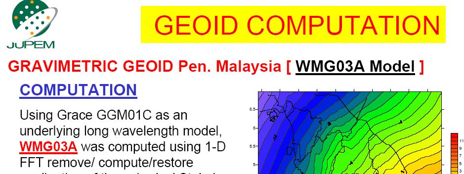
8 How do we obtain N? Gravimetric Geoid of Peninsular Malaysia (-15m to 11m)
9 How do we determine gravimetric geoid N? What is meant by gravimetric methods (of geoid determination) the term gravimetric methods refers to solutions of the GBVP where the geoidal heights/undulation are determined from gravity anomalies ( g) on the boundary surface. Typical solution of this type are Stokes integral and Molodensky s integral series - Geoid determine by Stokes-Helmert scheme. - Geoid derives from Stokes-modification formulae - Geoid computation using Molodensky s formulation.
10 Any other type of geoid? What is gravimetric geoid? Geometric geoid -obtained by using height information at BMs with measurement done by levelling and gps Hybrid geoid Fitted geoid; tailored geoid
11 Gravimetric Geoid vs Hybrid Geoid Gravimetric (geocentric) geoid Hybrid based on Earth Gravity Model, DEM data, and gravity measurements. eg. Current model USGG 03 (beta version USGG 09 is posted to NGS site) based on Gravimetric Model with datum transformations plus GPS on benchmarks eg. Current model is Geoid03 (beta version Geoid09 is posted to NGS site)

12
13 Some examples on geoiddevelopment worldwide Baltic countries Holland Australia USA Iran NZ and Taiwan
14 NKG Nordic GeoidModels - NKG96/NKG2002 -
15 Geoid of Holland The vanwilligen geoid de Min geoid (based on OSU91a geopotential model) NLGGEO2004 (based on EGM96 geopotentialmodel) and include in addition the terrestrial gravity data of Belgium and Germany.
16 Australian Geoid The 1st gravimetric co-geoid computed by Mather; using free-air gravity anomalies 1971 co-geoid calculated by Grushinsky and Shazina 1972 calculated by Fryer (co-geoid) 1986 calculated by Kearsley (co-geoid) 1989 calculated by Gilliland (co-geoid) AUSGEOID91 - Kearsley 1993 AUSGEOID 93 -Kearsley 1998 AUSGEOID 98 Featherstone et. al 2005 ; 2007 New geoid in preparation?? -Featherstone et. al Finally released in 2009 (AusGeoid 09)
17 Geoidfor the USA Geoid90 (Milbert 1991) Geoid96 (Smith & Milbert, 1999) Geoid99 (Smith & Roman 2001) US Gravimetric Geoid of 2009 (USGG2009) Wang et.al (2011)
18 Geoidof Iran (Iranian official geoid) Geoid (using R-C-R approach) KNTU Geoid (using Helmert scheme -UNB approach) Tehran U Geoid using ellipsoidal Bruns formula (Ardalan - Stuttgart Grafarend s approach) IRG04 KTH Sweden Kiamehr s work computed using LSMS approach
19 Geoid development in NZ & Taiwan The development of geoid model in New Zealand -NZGeoid05 (Amos, 2007) - NZGeoid09 (Claessens et.al, 2011) - both were quasigeoid instead of geoid -NZ Geoidmodellingat Otago University (Tenzer& Abdalla) Geoiddevelopment in Taiwan -Effort by Hwang (1997) -A new Taiwan Geoid (airbornegravitydata; using Stokes Helmert solution) -Ellmannet.al (2006)
20 Why geoidneed improvement? 1. new additional gravity data 2. new geopotential models 3. new global DEM (eg. STRM) 4. new approach in computation (new theoretical development / scheme; computation technique; new software). What is needed in geoid computation?
21 Sources of gravity data Type Advantage Disadvantage Terrestrial & Marine Accurate Straightforward Uneconomic in time and money, small area Airborne Satellite Fast, economic Covers all the earth Medium areas, lots of processing Bad accuracy for small area, lots of processing There is always a new set of additional data to consider!
22 New geopotentialmodel Examples of available global geopotential models; -OSU series -EGM96 -CHAMP & GRACE missions (eg. GGM02 from GRACE mission and Eigen-CG series from combined CHAMP & GRACE mission)
23 Digital Elevation Model (DEM) Examples of DEM currently used in geoid computation GLOBE (Global land one-km base elevation) ETOPO5 (5 x5 gridded land + seafloor elevation) -both are provided by NOAA SRTM (Shuttle Radar Topography Mission, a collaboration of NASA; NIMA; DLR German Space Agency & ASI Italian Space Agency)
24 Geoidcomputation techniques Stokes formulation Molodensky formulae Numerical integration Fast fourier transform (FFT) technique Least squares collocation approach Remove-compute-restore (combination of the above) the most widely used by IAG Most current softwares Stokes-HelmertScheme (UNB s Vanicek) & Least Squares Stokes Modification (KTH s Sjoberg)
25 Among most recent geoid South Africa (Wonnacott & Merry 2011) Moldova (2012-using KTH) Kazakhstan (KazGM using KTH) Poland (2012) Thailand (THAI12G& THAI12H) South Korea (KGeoid10)


26 Moldova Geoid 2012
D DAVID PUBLISHING. Towards a New Geoid Model of Tanzania Using Precise Gravity Data. 1. Introduction. Selassie David Mayunga
 Journal of Environmental Science and Engineering A 5 (2016) 267-276 doi:10.17265/2162-5298/2016.05.005 D DAVID PUBLISHING Towards a New Geoid Model of Tanzania Using Precise Gravity Data Selassie David
The History and Future of Geoid Modelling at UNB
 The History and Future of Geoid Modelling at UNB Robert Kingdon 1, Petr Vaníček and Marcelo Santos 1 Ph. D. Candidate, Department of Geodesy and Geomatics Engineering, University of New Brunswick, Fredericton,
Geoid Determination Based on a Combination of Terrestrial and Airborne Gravity Data in South Korea
 Geoid Determination Based on a Combination of Terrestrial and Airborne Gravity Data in South Korea by Hyo Jin Yang Report No. 507 Geodetic Science The Ohio State University Columbus, Ohio 43210 December
University of Cape Town
 UNIVERSITY OF CAPE TOWN FACULTY OF ENGINEERING AND THE BUILT ENVIRONMENT A comparison of the least squares collocation and the fast Fourier transform methods for gravimetric geoid determination. Author:
On Determination of a Regional Vertical Datum by Combination of EGM, Local Gravity and GPS/leveling Data
 On Determination of a Regional Vertical Datum by Combination of EGM, Local Gravity and GPS/leveling Data Pavel NOVÁK, Czech Republic Key words: geodetic heights, orthometric heights, normal heights, geoid,
A Preliminary Attempt of a Quasi-Geoid for Saudi Arabia
 A Preliminary Attempt of a Quasi-Geoid for Saudi Arabia Saad MOGREN, Saudi Arabia Key words: Geoid, Saudi Arabia, SUMMARY This proposal describes the need to undertake a national geoid (quasi-geoid) model
THE SITUATION IN EASTERN EUROPE ABOUT GEOID / QUASIGEOID MODELS DETERMINATION
 THE SITUATION IN EASTERN EUROPE ABOUT GEOID / QUASIGEOID MODELS DETERMINATION Petre Iuliu DRAGOMIR, Professor, PhD Technical University of Civil Engineering Bucharest, Faculty of Geodesy, pdragomir@rdslink.ro
Potential of the Iranian Geoid For GPS/Leveling
 Potential of the Iranian Geoid For GPS/Leveling Ramin Kiamehr Department of Surveying Engineering The University of Zanjan, Zanjan, Iran. P.O. Box 313 Tel: (+98-241-5283101-9) - Fax: 5283100 Email: rkiamehr@mail.znu.ac.ir
Evaluation of the Earth Gravity Model EGM2008 in Algeria
 Evaluation of the Earth Gravity Model EGM2008 in Algeria BENAHMED DAHO S. A. National Centre of Space Techniques, Geodetic Laboratory - BP 13 Arzew - 31200 - Algeria. E-mail: d_benahmed@hotmaii.com /Fax:
Geoid Determination In Uganda: Current Status
 Geoid Determination In Uganda: Current Status Ronald Ssengendo 1, Lars.E. Sjöberg 2, Anthony Gidudu 3 1 PhD Student, Faculty of Technology, Makerere University, P. O. Box 7062, Kampala, Uganda and Royal
The African Geoid Project and Its Relevance to the Unification of African Vertical Reference Frames
 The African Geoid Project and Its Relevance to the Unification of African Vertical Reference Frames Charles L MERRY, South Africa Key words: geoid, vertical datum, leveling. SUMMARY The African Geoid Project
Height systems. Rudi Gens Alaska Satellite Facility
 Rudi Gens Alaska Satellite Facility Outline Why bother about height systems? Relevant terms Coordinate systems Reference surfaces Geopotential number 2 Why bother about height systems? give a meaning to
Precision geoid determination by spherical FFT in and around the Korean peninsula
 Earth Planets Space, 51, 13 18, 1999 Precision geoid determination by spherical FFT in and around the Korean peninsula Hong-Sic Yun Department of Civil Engineering, Sungkyunkwan University, Korea (Received
The first high-precision gravimetric geoid of Hungary: HGG2013
 Server on Geodesy, Seismology and Environmental Sciences Published Online 2013 (http://airy.ual.es/) The first high-precision gravimetric geoid of Hungary: HGG2013 Abstract V. Corchete Higher Polytechnic
Status of the European Gravimetric Quasigeoid
 Status of the European Gravimetric Quasigeoid C. Voigt, H. Denker {voigt,denker}@ife.uni-hannover.de 1 Introduction 2 The European Gravity and Geoid Project (EGGP) 3 Data Sets 4 Quasigeoid Computation
A new geoid model for Bhutan. Machiel Bos Rui Fernandes
 A new geoid model for Bhutan Machiel Bos (machiel@segal.ubi.pt) Rui Fernandes (rui@segal.ubi.pt) June 2015 1 Definition of heights June 2015 2 Purpose of a geoid model Orthometric heights are the official
Proceedings of the First International Conference on Civil Engineering, Assiut University, Volume 2, pp , October 7-8.
 Proceedings of the First International Conference on Civil Engineering, Assiut University, Volume 2, pp. 246-253, October 7-8. PRODUCTIVE GPS TOPOGRAPHIC MAPPING FOR NATIONAL DEVELOPMENT PROJECTS IN EGYPT
A new technique to determine geoid and orthometric heights from satellite positioning and geopotential numbers
 J Geod 6 8: 4 1 DOI 1.17/s19-6-57-5 OIGINAL ATICLE L. E. Sjöberg A new technique to determine geoid and orthometric heights from satellite positioning and geopotential numbers eceived: 19 September 5 /
GEOID UNDULATIONS OF SUDAN USING ORTHOMETRIC HEIGHTS COMPARED WITH THE EGM96 ANG EGM2008
 GEOID UNDULATIONS OF SUDAN USING ORTHOMETRIC HEIGHTS COMPARED Dr. Abdelrahim Elgizouli Mohamed Ahmed* WITH THE EGM96 ANG EGM2008 Abstract: Positioning by satellite system determine the normal height above
Height systems. Rüdiger Gens
 Rüdiger Gens 2 Outline! Why bother about height systems?! Relevant terms! Coordinate systems! Reference surfaces! Geopotential number! Why bother about height systems?! give a meaning to a value defined
IMPROVED DETERMINATION OF HEIGHTS USING A CONVERSION SURFACE BY COMBINING GRAVIMETRIC QUASI-GEOID/GEOID AND GPS-LEVELLING HEIGHT DIFFERENCES ABSTRACT
 IMPROVED DETERMINATION OF HEIGHTS USING A CONVERSION SURFACE BY COMBINING GRAVIMETRIC QUASI-GEOID/GEOID AND GPS-LEVELLING HEIGHT DIFFERENCES H. NAHAVANDCHI, A. SOLTANPOUR Norwegian University of Science
Activities in South America: Gravity and Geoid Projects
 Activities in South America: Gravity and Geoid Projects Segundo Taller de Grupo de Trabajo I SIRGAS Montevideo - Uruguay May 26 a 30, 2008 Maria Cristina Pacino Universidade de Rosário CGED - IBGE Denizar
Preliminary study of the Gravimetric Local Geoid Model in Jordan: case study (GeoJordan Model)
") ANNALS OF GEOPHYSICS, VOL. 50, N. 3, June 2007 Preliminary study of the Gravimetric Local Geoid Model in Jordan: case study (GeoJordan Model) Omar Al-Bayari and Abdallah Al-Zoubi Department of Surveying
ANNALS OF GEOPHYSICS, VOL. 50, N. 3, June 2007 Preliminary study of the Gravimetric Local Geoid Model in Jordan: case study (GeoJordan Model) Omar Al-Bayari and Abdallah Al-Zoubi Department of Surveying
Towards The Modernization Of Indian Vertical Datum
 Towards The Modernization Of Indian Vertical Datum Dr. S. K. SINGH KEYWORDS:- geo-potential value; tide gauge; vertical datum; GNSS/ Levelling BMs; Global geo-potential Model. SUMMARY:- A National vertical
Comparing 10 Different Interpolation Methods Used to Determine Geoidquasigeoid Separation (Case Study in Iran)
") J. Basic. Appl. Sci. Res., 2(8)8292-8299, 2012 2012, TextRoad Publication ISSN 2090-4304 Journal of Basic and Applied Scientific Research www.textroad.com Comparing 10 Different Interpolation Methods Used
J. Basic. Appl. Sci. Res., 2(8)8292-8299, 2012 2012, TextRoad Publication ISSN 2090-4304 Journal of Basic and Applied Scientific Research www.textroad.com Comparing 10 Different Interpolation Methods Used
PGM2016: A new geoid model for the. Philippines
 PGM2016: A new geoid model for the Philippines United Nations/Nepal Workshop on the Applications of Global Navigation Satellite Systems Kathmandu, Nepal December 12-16, 2016 Ronaldo Gatchalian, Chief Geodesy
REFINED GEOID MODEL FOR THE UNITED ARAB EMIRATES
 REFINED GEOID MODEL FOR THE UNITED ARAB EMIRATES Sahrum Ses 1, Adel Khaleefa and Rene Forsberg 3 1 UTM GNSS and Geodynamics Research Group, Universiti Teknologi Malaysia Military Survey Departments, GHQ
Latest Geoid Determinations for the Republic of Croatia
 Latest Geoid Determinations for the Republic of Croatia T. Bašić *, Ž. Hećimović ** * Faculty of Geodesy, University of Zagreb, HR-10000 Zagreb, Kačićeva 26, Croatia ** Av. M. Držića 76, 10000 Zagreb,
National Report of Sweden
 National Report of Sweden NKG geoid WG meeting Jonas Ågren jonas.agren@lm.se Jonas Ågren, 2010-03-09, Masala Summary of Swedish geoid activities Updated GNSS/levelling observations. New gravimetric quasigeoid
The progress of the geoid in south America under GRACE and EGM08 models
 University of São Paulo The progress of the geoid in south America under GRACE and EGM08 models Polytechnic School Brazilian Institute of Geography and Statistics D. Blitzkow (E-mail: dblitzko@usp.br)
Ramin Kiamehr. Doctoral Dissertation in Geodesy. Royal Institute of Technology (KTH) Department of Transport and Economics Division of Geodesy
 Department of Transport and Economics Division of Geodesy") ROYAL INSTITUTE OF TECHNOLOGY Precise Gravimetric Geoid Model for Iran Based on GRACE and SRTM Data and the Least-Squares Modification of Stokes Formula with Some Geodynamic Interpretations Ramin Kiamehr
ROYAL INSTITUTE OF TECHNOLOGY Precise Gravimetric Geoid Model for Iran Based on GRACE and SRTM Data and the Least-Squares Modification of Stokes Formula with Some Geodynamic Interpretations Ramin Kiamehr
Presented at the FIG Congress 2018, May 6-11, 2018 in Istanbul, Turkey
 Presented at the FIG Congress 2018, May 6-11, 2018 in Istanbul, Turkey A Geoid model of northern Chile from airborne and surface gravity Geographic Description of Chile. Total Surface: 2,006,096 Km 2.
New height reference surfaces for Norway
 154 European Vertical System New height reference surfaces for Norway D. SOLHEIM 1 Abstract In this article the computation of height reference surfaces at Statens kartverk is described. The difference
New gravimetric quasigeoid of Slovakia
 BOLLETTINO DI GEOFISICA TEORICA ED APPLICATA VOL. 40, N. 3-4, pp. 211-217; SEP.-DEC. 1999 New gravimetric quasigeoid of Slovakia M. MOJZEŠ and J. JANÁK Departament of Theoretical Geodesy, Slovak University
Ellipsoidal area mean gravity anomalies precise computation of gravity anomaly reference fields for remove-compute-restore geoid determination
 Ellipsoidal area mean gravity anomalies precise computation of gravity anomaly reference fields for remove-compute-restore geoid determination C. Hirt Western Australian Centre for Geodesy & The Institute
Evaluation and Improvement of the EGG97 Quasigeoid Model for Europe by GPS and Leveling Data
 Evaluation and Improvement of the EGG97 Quasigeoid Model for Europe by GPS and Leveling Data Heiner Denker Institut für Erdmessung, Universität Hannover, Schneiderberg 50, D-30167 Hannover, Germany E-mail:
ESTIMATION OF ORTHOMETRIC HEIGHT USING EGM2008 AND GPS OVER NAIROBI COUNTY AND ITS ENVIRONS
 Estimation of orthometric height JAGST Vol. 17(2) 2016 ESTIMATION OF ORTHOMETRIC HEIGHT USING EGM2008 AND GPS OVER NAIROBI COUNTY AND ITS ENVIRONS K. E. Kemboi and P. A. Odera Department of Geomatic Engineering
GRAVITY ANOMALY ASSESSMENT USING GGMS AND AIRBORNE GRAVITY DATA TOWARDS BATHYMETRY ESTIMATION
 GRAVITY ANOMALY ASSESSMENT USING GGMS AND AIRBORNE GRAVITY DATA TOWARDS BATHYMETRY ESTIMATION A Tugi a, A H M Din a,b *, K M Omar a, A S Mardi a, Z A M Som a, A H Omar a, N A Z Yahaya a, N Yazid a a Geomatic
NGS is Scheduled to Replace NAVD 88 and NAD 83 In 2022
 NGS is Scheduled to Replace NAVD 88 and NAD 83 In 2022 Indiana Society of Professional Land Surveyors Conference January 2017 John Ellingson NGS Geodetic Advisor john.ellingson@noaa.gov 202-306-6904 1
Fitting Gravimetric Local and Global Quasi-Geoids to GPS/Levelling Data: The Role of Geoid/Quasi-Geoid Variations
 JKAU: Eng. Sci., Vol.20 No.1, pp: 47-59 (2009 A.D. / 1430 A.H.) Fitting Gravimetric Local and Global Quasi-Geoids to GPS/Levelling Data: The Role of Geoid/Quasi-Geoid Variations Gomaa M. Dawod (1, 2) and
Global vertical datum unification based on the combination of the fixed gravimetric and the scalar free geodetic boundary value problems
 Global vertical datum unification based on the combination of the fixed gravimetric and the scalar free geodetic boundary value problems Laura Sánchez contribution to the IAG-IC.: Vertical Reference Frames
Why do we need a proper geoid
 Why do we need a proper geoid Petr Vaníček Department of Geodesy and Geomatics Engineering University of New Brunswick P.O. Box 4400 Fredericton, N.B. CND E3B 53 1 My working hypothesis: Let us all agree
Localised Geoid Modelling using GPS and Precise Levelling Data
 University of Southern Queensland Faculty of Engineering and Surveying Localised Geoid Modelling using GPS and Precise Levelling Data A dissertation submitted by Mr. Frazer Munro in fulfilment of the requirements
Coordinate Systems. Location on earth is defined by coordinates
 Coordinate Systems We think of the earth as a sphere It is actually a spheroid (ellipsoid), slightly larger in radius at the equator than at the poles Shape of the Earth Location on earth is defined by
Using gravity and topography-implied anomalies to assess data requirements for precise geoid computation
 JGeod DOI 10.1007/s00190-009-0337-y ORIGINAL ARTICLE Using gravity and topography-implied anomalies to assess data requirements for precise geoid computation Christopher Jekeli Hyo Jin Yang Jay H. Kwon
Progress Towards a Centimeter Geoid for Dubai Emirate
 Progress Towards a Centimeter Geoid for Dubai Emirate Y. AL MARZOOQI, H. FASHIR and Syed Iliyas AHMED, Dubai, United Arab Emirates and R. FORSBERG and G. STRYKOWSKI, Denmark Key words: GPS, Gravity, Geoid,
GEOID UNDULATION DIFFERENCES BETWEEN GEOPOTENTIAL. RICHARD H. RAPP and YAN MING WANG
 GEOID UNDULATION DIFFERENCES BETWEEN GEOPOTENTIAL MODELS RICHARD H. RAPP and YAN MING WANG Department of Geodetic Science and Surveying, The Ohio State University, Columbus, Ohio, U.S.A. (Received 15 September,
Splinter meeting at GGHS2016 Wednesday, Sept. 21, 2016 Laura Sánchez
 Working Group on the Strategy for the Realization of the International Height Reference System (IHRS) Splinter meeting at GGHS2016 Wednesday, Sept. 21, 2016 Laura Sánchez -Brainstorming and definition
Geodesy, Geoids, and Vertical Datums: A Perspective from the U.S. National Geodetic Survey
 Geodesy, Geoids, and Vertical Datums: A Perspective from the U.S. National Geodetic Survey, UNITED STATES Key words: Positioning, Heights, GPS/Leveling, Remote Sensing, Coastal Zone Management SUMMARY
Geopotential numbers from GPS satellite surveying and disturbing potential model: a case study of Parana, Brazil
 Note: This is the accepted version of the ms 10.1515/JAG.2011.016 available at: http://www.degruyter.com/view/j/jag.2011.5.issue-3-4/jag.2011.016/jag.2011.016.xml Journal of Applied Geodesy Geopotential
White Rose Research Online URL for this paper: Version: Accepted Version
 This is a repository copy of Utilisation of Fast Fourier Transform and Least-squares Modification of Stokes formula to compile approximate geoid heights over Khartoum State: Sudan. White Rose Research
A HEIGHT DATUM FOR UGANDA BASED ON A GRAVIMETRIC QUASIGEOID MODEL AND GNSS/LEVELLING
 ROYAL INSTITUTE OF TECHNOLOGY A HEIGHT DATUM FOR UGANDA BASED ON A GRAVIMETRIC QUASIGEOID MODEL AND GNSS/LEVELLING Ronald Ssengendo Doctoral Dissertation in Geodesy Royal Institute of Technology (KTH)
Some Mathematical Problems of the Geoid Determination in the Coastal Areas of the Gulf of Mexico
 Some Mathematical Problems of the Geoid Determination in the Coastal Areas of the Gulf of Mexico Alexey L. Sadovski, Gary Jeffress, Hong-Zhi Song, Natalya Warner, Department of Mathematics and Statistics
HOW CAN YOU ESTIMATE THE GEOID UNDULATION BY LEAST SQUARE COLLOCATION TECHNIQUE AND GPS DATA?
 УДК M. Kaloop, H. EL-Shmbaky, Ashraf A. Beshr Mansoura University, EGYPT HOW CAN YOU ESTIMATE THE GEOID UNDULATION BY LEAST SQUARE COLLOCATION TECHNIQUE AND GPS DATA? Abstract Levels have been normally
We are IntechOpen, the world s leading publisher of Open Access books Built by scientists, for scientists. International authors and editors
 We are IntechOpen, the world s leading publisher of Open Access books Built by scientists, for scientists 4,000 116,000 120M Open access books available International authors and editors Downloads Our
Development and evaluation of a new Canadian geoid model
 BOLLETTINO DI GEOFISICA TEORICA ED APPLICATA VOL. 40, N. 3-4, pp. 227-238; SEP.-DEC. 1999 Development and evaluation of a new Canadian geoid model G. FOTOPOULOS, C. KOTSAKIS and M.G. SIDERIS Department
UCGE Reports Number 20344
 UCGE Reports Number 20344 Department of Geomatics Engineering Geoid Investigations for the New Vertical Datum in Canada (URL: http://www.geomatics.ucalgary.ca/graduatetheses) by Elmas Sinem Ince December
CENTIMETRE LEVEL OF ACCURACY OF QUASIGEOID MODEL IN POLAND
 CENTIMETRE LEVEL OF ACCURACY OF QUASIGEOID MODEL IN POLAND Jan Krynski Institute of Geodesy and Cartography, Poland krynski@igik.edu.pl Adam Lyszkowicz University of Warmia and Mazury in Olsztyn, Poland
EPUSP. ( Escola Politécnica da Universidade de São Paulo
 EPUSP Escola Politécnica da Universidade de São Paulo Present and Future of the gravity surveys and geoid model in South America Denizar Blitzkow Ana Cristina Oliveira Cancoro de Matos Gabriel do Nascimento
Preliminary geoid mapping results by Fugro s improved Micro-g LaCoste turnkey airborne gravity system
 J. Geod. Sci. 2015; 5:80 96 Research Article Open Access D. Zhong* and R. W. Kingdon Preliminary geoid mapping results by Fugro s improved Micro-g LaCoste turnkey airborne gravity system DOI 10.1515/jogs-2015-0009
What s Up? Tidal and Vertical Datums. Noel Zinn Hydrometronics LLC July 2011, revised November 2013
 What s Up? Tidal and Vertical Datums Noel Zinn Hydrometronics LLC www.hydrometronics.com July 2011, revised November 2013 1 Motivation The real world is three-dimensional, therefore, coordinates are necessarily
A high-resolution gravimetric geoid model for Japan from EGM2008 and local gravity data
 Earth Planets Space, 64, 361 368, 2012 A high-resolution gravimetric geoid model for Japan from EGM2008 and local gravity data Patroba Achola Odera 1, Yoichi Fukuda 1, and Yuki Kuroishi 2 1 Graduate School
A Digital Elevation Model for Egypt by Collocation
 A Digital Elevation Model for Egypt by Collocation Dr. Maher Mohamed Amin 1 Dr. Saadia Mahmoud El-Fatairy 1 Eng. Raaed Mohamed Hassouna 2 1 Lecturer of Surveying, Surveying Department, Shoubra Faculty
New Zealand Vertical Datum 2004/05 Milestone 6b Completion Report
 New Zealand Vertical Datum 2004/05 Milestone 6b Completion Report Office of the Surveyor-General 28 June 2005 Page 2 of 24 1 Introduction The goal of the Vertical Datum Project is to produce a new nationally
Empirical Geoid Modelling Using Classical Gravimetric Method.
 Empirical Geoid Modelling Using Classical Gravimetric Method. Joseph Olayemi ODUMOSU, Kevin M. KELLY, Olushola Gabriel OMOGUNLOYE Quadri A. ADEJARE, Olufemi O. ADELEKE, ) Abdulmalik. M. OLANIYI Keywords:
Practical Determination of Geoidal Undulation and Geoidal Map of Part of Mubi, Adamawa State, Nigeria
 Practical Determination of Geoidal Undulation and Geoidal Map of Part of Mubi, Adamawa State, Nigeria Aleem, K. F 1 1 Department of Surveying and Geoinformatics, Abubakar Tafawa Balewa University, Bauchi.
The National Spatial Reference System of the Future
 The National Spatial Reference System of the Future William Stone Southwest Region (AZ, NM, NV, UT) Geodetic Advisor william.stone@noaa.gov NOAA s National Geodetic Survey geodesy.noaa.gov Salt Lake City
Accuracy Assessment of the Gravitational Geoid Model of Hilla Area, Iraq
 International Journal of Current Engineering and Technology E-ISSN 2277 4106, P-ISSN 2347 5161 2016 INPRESSCO, All Rights Reserved Available at http://inpressco.com/category/ijcet Research Article Accuracy
UNB application of Stokes Helmert s approach to geoid computation
 Journal of Geodynamics 4 (2007) 200 21 UNB application of Stokes Helmert s approach to geoid computation A. Ellmann,P.Vaníček Department of Geodesy and Geomatics Engineering, University of New Brunswick
GRAV-D. Gravity for the Re-definition of the American Vertical Datum
 GRAV-D Gravity for the Re-definition of the American Vertical Datum Why this briefing? NGS recently acquired a new airborne gravimeter Intended to support GRAV-D GRAV-D is an ambitious new plan for NGS
Why Do We Need a Proper Geoid?
 Petr VANÍČEK, Canada Key words: gravity field, datum for heights, geoid, orthometric heights. SUMMARY This contribution enumerates some of the reasons for any country to have an appropriately computed,
Geographic Information Systems class # 1 February 19, Coordinate reference systems in GIS: geodetic coordinates
 Geographic Information Systems class # 1 February 19, 2013 Coordinate reference systems in GIS: geodetic coordinates Manuel Campagnolo ISA Manuel Campagnolo (ISA) GIS/SIG 2012 2013 February 19, 2013 1
REFINEMENT OF A GRAVIMETRIC GEOID USING GPS AND LEVELLING DATA
 REFINEMENT OF A GRAVIMETRIC GEOID USING GPS AND LEVELLING DATA W. E. Featherstone School of Spatial Sciences, Curtin University of Technology, GPO Box U1987, Perth, WA 6845, Australia. tel: +61 8 9266
Final VRF grids Date: Aug 25, 2011 Author: R. Forsberg, G. Strykowski, O. Andersen
 Final VRF grids Date: Aug 25, 2011 Author: R. Forsberg, G. Strykowski, O. Andersen www.blast-project.eu 1 Authors Name Organisation Rene Forsberg National Space Institute, DTU G. Strykowski National Space
ifp Schriftenreihe der Institute des Studiengangs Geodäsie und Geoinformatik
 Universität Stuttgart Schriftenreihe der Institute des Studiengangs Geodäsie und Geoinformatik Technical Reports Department of Geodesy and Geoinformatics G I G. Fotopoulos, C. Kotsakis, M.G. Sideris Stuttgart
Beyond GEOID12: Implementing a New Vertical Datum for North America
 Daniel R. ROMAN, Neil D. WESTON, UNITED STATES Key words: Positioning, Heights, GPS/Leveling, Geoid, Vertical Datum SUMMARY The National Geodetic Survey (NGS) is responsible for maintaining both the horizontal
A Preliminary Gravitational Model to Degree 2160
 A Preliminary Gravitational Model to Degree 2160 N.K. Pavlis, S.A. Holmes Raytheon ITSS Corporation, 1616 McCormick Drive, Upper Marlboro, Maryland 20774, USA Nikolaos_Pavlis@raytheon.com Fax: +301-883-4140
Numerical solution of the fixed gravimetric BVP on the Earth s surface its possible contribution to the realization of IHRS.
 Numerical solution of the fixed gravimetric BVP on the Earth s surface its possible contribution to the realization of IHRS. Róbert Čunderlík cunderli@svf.stuba.sk Dept. of Mathematics and Descriptive
A Combined DGPS/INS and Synthetic Aperture Radar System for Geoid Referenced Elevation Models and Ortho-Rectified Image Maps
 A Combined DGPS/INS and Synthetic Aperture Radar System for Geoid Referenced Elevation Models and Ortho-Rectified Image Maps C. L. Glennie, K. P. Schwarz and A.M. Bruton, Department of Geomatics Engineering,
Regional Geoid Determination Methods for the Era of Satellite Gravimetry
 Regional Geoid Determination Methods for the Era of Satellite Gravimetry Numerical Investigations Using Synthetic Earth Gravity Models Jonas Ågren Doctoral Dissertation in Geodesy Royal Institute of Technology
Practical Local Geoid Model Determination for Mean Sea Level Heights of Surveys and Stable Building Projects
 IOSR Journal of Environmental Science, Toxicology and Food Technology (IOSR-JESTFT) e-issn: 2319-2402,p- ISSN: 2319-2399.Volume 12, Issue 6 Ver. I (June. 2018), PP 30-37 www.iosrjournals.org Practical
Improved Official Geoid Model for Israel, 2008
 Hezi SARID, Hsein NASR-ALDIN and Dan SHARNI, Israel Key words: geoid, undulation, EGM2008, WGS84, gravity anomaly SUMMARY The Survey of Israel (SOI) has 849 anchor-points, where orthometric and ellipsoidal
HEIGHT SYSTEM MODERNIZATION AND GEOID MODELLING STUDIES IN TURKEY
 Presented at the FIG Congress 2018, May 6-11, 2018 in Istanbul, Turkey HEIGHT SYSTEM MODERNIZATION AND GEOID MODELLING STUDIES IN TURKEY İrem YAKAR Istanbul Technical University,Turkey TALK OUTLINE Turkey
Performance Evaluation of AUSGeoid2020 in NSW
 International Global Navigation Satellite Systems Association IGNSS Symposium 2018 Colombo Theatres, Kensington Campus, UNSW Australia 7 9 February 2018 Performance Evaluation of AUSGeoid2020 in NSW Volker
GEOIDS FAQ. November
 GEOIDS FAQ 1. What is a geoid? A geoid is a representation of the equipotential surface of the Earth s gravity field. It can be thought of as a surface coinciding with the undisturbed mean sea level extended
Vertical Reference Frame Pacific
 Vertical Reference Frame Pacific Andrick Lal SPC Geoscience Division GIS&RS User Conference 29 th November 2016 USP, Fiji. What does it mean? All buildings and features have a height. But what is it relative
A Geoid Model Of Northern Chile From Airborne And Surface Gravity
 A Geoid Model Of Northern Chile From Airborne And Surface Gravity Julio NEIRA and Cristian Carrasco, Chile Key words: Geoid, Airborne Gravity, Geodesy, Gravimetry SUMMARY In recent decades many countries
IMPROVING GEOID DETERMINATION OVER MOROCCO AREA USING GOCE LEVEL 2 DATA
 IMPROVING GEOID DETERMINATION OVER MOROCCO AREA USING GOCE LEVEL 2 DATA EL Hassan EL BRIRCHI (1), Driss EL AZZAB (2) (1) Hassania School of Public Works, km 7, Route d El Jadida B.P 8108 Oasis Casablanca
Coastal geoid improvement using airborne gravimetric data in the United Arab Emirates
 International Journal of Physical Sciences Vol. 7(45), pp. 6012-6023, 30 November, 2012 Available online at http://www.academicjournals.org/ijps DOI: 10.5897/IJPS12.413 ISSN 1992-1950 2012 Academic Journals
Towards an improvement of the geoid model in Japan by GOCE data: A case study of the Shikoku area
 LETTER Earth Planets Space, 65, 361 366, 2013 Towards an improvement of the geoid model in Japan by GOCE data: A case study of the Shikoku area Patroba Achola Odera and Yoichi Fukuda Graduate School of
Session 2.2: Gravity and WHS
 Daniel R. Roman, Ph.D. National Oceanic and Atmospheric Administration National Ocean Service, National Geodetic Survey Geosciences Research Division Silver Spring, Maryland U.S.A. Session 2.2 Program
Evaluating the Performance of AUSGeoid2020 in NSW
 Evaluating the Performance of AUSGeoid2020 in NSW Volker Janssen Spatial Services NSW Department of Finance, Services & Innovation Volker.Janssen@finance.nsw.gov.au Tony Watson Spatial Services NSW Department
Dependences in the pillar Earth s gravity field of
 Reports on Geodesy, vol. 92, no. 1, 2012 Dependences in the pillar Earth s gravity field of GGOS - description using UML notation Małgorzata Paśnicka 1, Karolina Szafranek 2, Agnieszka Zwirowicz Rutkowska
Earth2012 Spherical harmonic models of Earth's topography and potential
 Note the 5arc-min Earth2012 models have been updated with the Earth2014 1-arcmin models which offer higher spatial resolution and a more up-to-date description of Earth s topography, ice bedrock and other
EUROPEAN GRAVIMETRIC GEOID: STATUS REPORT 1994
 EUROPEAN GRAVIMETRIC GEOID: STATUS REPORT 1994 Heiner Denker, Dirk Behrend, Wolfgang Torge Institut für Erdmessung, University of Hannover, Nienburger Straße 6 D-30167 Hannover, Federal Republic of Germany
Numerical Investigation on Spherical Harmonic Synthesis and Analysis
 Numerical Investigation on Spherical Harmonic Synthesis and Analysis Johnny Bärlund Master of Science Thesis in Geodesy No. 3137 TRITA-GIT EX 15-006 School of Architecture and the Built Environment Royal
HIMALAYAN AIRBORNE GRAVITY AND GEOID OF NEPAL
 Mt. Everest HIMALAYAN AIRBORNE GRAVITY AND GEOID OF NEPAL -Niraj Manandhar Head, Geodetic Survey Branch Survey Department, Geodetic Survey Branch Project Background Air Borne Gravity Survey Project was
Gis-Based Accuracy Assessment of Global Geopotential Models: A Case Study of Egypt
 American Journal of Geographic Information System 2018, 7(4): 118-124 DOI: 10.5923/j.ajgis.20180704.03 Gis-Based Accuracy Assessment of Global Geopotential Models: A Case Study of Egypt Ahmed El Shouny
Transforming ellipsoidal heights and geoid undulations between different geodetic reference frames
 JGeod DOI 10.1007/s00190-007-0174-9 ORIGINAL ARTICLE Transforming ellipsoidal heights and geoid undulations between different geodetic reference frames Christopher Kotsakis Received: 29 September 2006
A global high resolution mean sea surface from multi mission satellite altimetry
 BOLLETTINO DI GEOFISICA TEORICA ED APPLICATA VOL. 40, N. 3-4, pp. 439-443; SEP.-DEC. 1999 A global high resolution mean sea surface from multi mission satellite altimetry P. KNUDSEN and O. ANDERSEN Kort