CENTIMETRE LEVEL OF ACCURACY OF QUASIGEOID MODEL IN POLAND
|
|
|
- Justin Warner
- 5 years ago
- Views:
Transcription
1 CENTIMETRE LEVEL OF ACCURACY OF QUASIGEOID MODEL IN POLAND Jan Krynski Institute of Geodesy and Cartography, Poland Adam Lyszkowicz University of Warmia and Mazury in Olsztyn, Poland
2 Outline
3 Introduction Geoid/quasigeoid models in Poland first gravimetric geoid model for the region of Central Europe, including Poland (accuracy ~3 m) first astro-geodetic geoid for Poland (accuracy 60 cm) first astro-gravimetric geoid for Poland (accuracy 30 cm) first gravimetric quasigeoid model for Poland, using the LS collocation combined with the integral method (accuracy 10 cm) gravimetric quasigeoid model for Poland, using the FFT technique (accuracy 5 cm) need for centimetre quasigeoid in Poland extensive research on precise geoid/quasigeoid model in Poland with the use of all available geodetic, gravimetric, astronomic, satellite and geological data
 - mean Δg (neighbouring countries) (σ = 1.0 mgal) marine -Zaria 1971 (σ = 2.0 mgal ) - Turlejski 1972 (σ = 2.")
 altimetry - ERS-1, GEOSAT 1998 (σ = 4.0 mgal) POLREF - 360 sites: δφ (0.5-1.0 cm), δλ (0.5-1.0 cm), δh (1.0-1.")
 - 165: σ = 0.")
 EUVN (1997, 1999) WSSG (1994-96) 1999-2002 levelling campaign: 382 levelling lines (total length")
4 gravity data GPS/levelling data Data used (1) terrestrial - point Δg (Poland) (σ = mgal) - mean Δg (neighbouring countries) (σ = 1.0 mgal) marine -Zaria 1971 (σ = 2.0 mgal ) - Turlejski 1972 (σ = 2.0 mgal) - Petrobaltic 1978/1980 (σ = 0.5 mgal) - Haakon Mosby 2000 (σ = 2.6 mgal) airborne - KMS 1999 (σ = 1.5 mgal) altimetry - ERS-1, GEOSAT 1998 (σ = 4.0 mgal) POLREF sites: δφ ( cm), δλ ( cm), δh ( cm) EUVN -52 sites:δφ = 0.19 cm, δλ = 0.22 cm, δh = 0.28 cm WSSG sites: δφ = 2 cm, δλ = 2 cm, δh = 3 cm deflections of the vertical astro-geodetic ( ) - 165: σ = 0.5 astro-gravimetric (1960) -376:σ = 0.7 new astro-geodetic ( ) -29:σ = 0.3 levelling data POLREF ( ) EUVN (1997, 1999) WSSG ( ) levelling campaign: 382 levelling lines (total length km, average length ~46 km) sections (average length 1.1 km), 135 loops, 245 nodal points rms of lev. ±0.278 mm/km 1/2, rand. error ±0.264 mm/km 1/2, syst. error ±0.080 mm/km, σ of unit weight to ±0.088 mm/km


 map of")
 mean = 2.")
5 Data used (2) digital terrain models tide gauge data 25 tide gauges from Danish, Finnish, German, Polish and Swedish coast line (monthly and annual means from at least 50 years) lithosphere density data points of evaluated lithosphere density above the sea level (1363; 1/230 km 2 ) map of lithosphere density above the sea level (range gcm -3 ) mean = 2.17 gcm -3 ; σ = 0.15 gcm -3
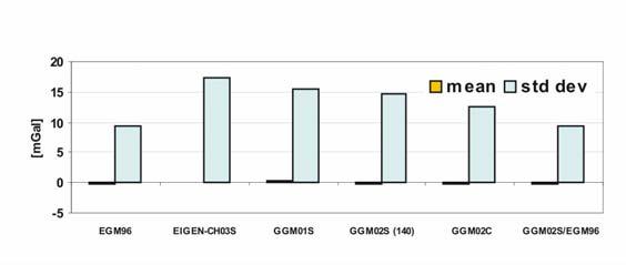
6 Geopotential models GM vs POLREF [m] GM vs Δg [mgal]
![Terrain corrections The optimum maximum integration radius [km] for different distortions of terrain elevation Map of](/docs-images/94/121849182/images/7-1.jpg "calculated 2005 ter. corr.")
7 Terrain corrections The optimum maximum integration radius [km] for different distortions of terrain elevation Map of calculated 2005 ter. corr. at gravity stations [mgal] Differences between the 1992 and 2005 terrain corrections [mgal]

8 Mean gravity anomalies F F F 1. Point free-air anomalies Δg P ' on the geoid Δg P' = g P + δg P γ P0 F with δg = h Faye g P ' B Δg P ' 2. Point Faye anomalies on the geoid Δ 3. Point Bouguer anomalies Δg Faye P' P Δ g = Δg + c B P' = Δg Faye P' F P' P 2πρ h 4. Interpolation of point Bouguer anomalies ( ) and terrain elevations ( ) on the grid of higher resolution then the resultant grid of mean Faye anomalies B B 1 int 5. Calculation of mean Bouguer anomalies Δg Δg = Δgi Δσ σ i in 1' 1' blocks 1 int 6. Calculation of mean heights h in 1' 1' blocks h = h i Δσ σ i Faye Faye B 7. Calculation of mean Faye anomalies Δg in 1' 1' Δg = Δg + 2πρh blocks Δg i int P int h i P Concept of calculating mean gravity anomalies
 49 stations (24h or 2 24h) (determined using EPN strategy) 141 stations (4h) (determined using 24h stations as fix) The fit of the heights of the control traverse to the")
9 868 km total length Control traverse GPS/levelling traverse stations at the benchmarks of 1 st and 2 nd order precise levelling network 190 stations (every 4.6 km) 49 stations (24h or 2 24h) (determined using EPN strategy) 141 stations (4h) (determined using 24h stations as fix) The fit of the heights of the control traverse to the GUGiK 2001 quasigeoid

![corr) fitting to the POLREF sites [cm] pure numerical [cm] GPS/levelling](/docs-images/94/121849182/images/10-3.jpg "quasigeoid - EUREF-POL, POLREF, EUVN, WSSG (kriging, min. curv.")

![[cm] Best fitted quasigeoid - gravimetric quasigeoid fitted to](/docs-images/94/121849182/images/10-5.jpg "GPS/levelling The fit of best fitted quasigeoid model to the POLREF")
10 Quasigeoid models developed Astro-geodetic geoid Astro-gravimetric geoid Gravimetric quasigeoid - different models (gravity data, GM, terr. corr) fitting to the POLREF sites [cm] pure numerical [cm] GPS/levelling quasigeoid - EUREF-POL, POLREF, EUVN, WSSG (kriging, min. curv.) Integrated quasigeoid - GPS/levelling + gravity + terrain model fitting to the POLREF, EUVN and WSSG sites [cm] with gravity support [cm] Best fitted quasigeoid - gravimetric quasigeoid fitted to GPS/levelling The fit of best fitted quasigeoid model to the POLREF sites [cm] (mean difference: 1.0 cm)

11 Quality of quasigeoid models Fit of quasigeoid models to GPS/levelling control traverse [cm]
12 Summary and conclusions (1) All available data has been gathered, extensively qualitatively and quantitatively analysed, verified, and unified The data has been archived and appropriate databases were developed Precise terrain corrections were calculated for all gravity data Control GPS/levelling traverse established is a powerful tool for quality control of precise quasigeoid models in Poland Quality of heights of the POLREF sites is not sufficient for quality control of precise quasigeoid models in Poland
13 Summary and conclusions (2) New astro-geodetic geoid model gravimetric quasigeoid models as well as best fitted quasigeoid model and integrated quasigeoid model based on gravity, GPS/levelling and topographic data were developed Accuracy of the developed quasigeoid models has been evaluated astro-geodetic 21 cm gravimetric 2.2 cm best-fitted 2.0 cm integrated 1.8 cm Developed methods and computing strategies as well as experience gained reflect high potentiality for further research on developing precise quasigeoid models in Poland
Did the new geopotential models improve the fit of gravimetric quasigeoid in Poland to GPS/levelling data?
 Did the new geopotential models improve the fit of gravimetric quasigeoid in Poland to GPS/levelling data? J. KRYNSKI 1, A. LYSZKOWICZ 2 Abstract The choice of global geopotential model used in remove-restore
PGM2016: A new geoid model for the. Philippines
 PGM2016: A new geoid model for the Philippines United Nations/Nepal Workshop on the Applications of Global Navigation Satellite Systems Kathmandu, Nepal December 12-16, 2016 Ronaldo Gatchalian, Chief Geodesy
Evaluation and Improvement of the EGG97 Quasigeoid Model for Europe by GPS and Leveling Data
 Evaluation and Improvement of the EGG97 Quasigeoid Model for Europe by GPS and Leveling Data Heiner Denker Institut für Erdmessung, Universität Hannover, Schneiderberg 50, D-30167 Hannover, Germany E-mail:
New gravimetric quasigeoid of Slovakia
 BOLLETTINO DI GEOFISICA TEORICA ED APPLICATA VOL. 40, N. 3-4, pp. 211-217; SEP.-DEC. 1999 New gravimetric quasigeoid of Slovakia M. MOJZEŠ and J. JANÁK Departament of Theoretical Geodesy, Slovak University
Status of the European Gravimetric Quasigeoid
 Status of the European Gravimetric Quasigeoid C. Voigt, H. Denker {voigt,denker}@ife.uni-hannover.de 1 Introduction 2 The European Gravity and Geoid Project (EGGP) 3 Data Sets 4 Quasigeoid Computation
THE SITUATION IN EASTERN EUROPE ABOUT GEOID / QUASIGEOID MODELS DETERMINATION
 THE SITUATION IN EASTERN EUROPE ABOUT GEOID / QUASIGEOID MODELS DETERMINATION Petre Iuliu DRAGOMIR, Professor, PhD Technical University of Civil Engineering Bucharest, Faculty of Geodesy, pdragomir@rdslink.ro
D DAVID PUBLISHING. Towards a New Geoid Model of Tanzania Using Precise Gravity Data. 1. Introduction. Selassie David Mayunga
 Journal of Environmental Science and Engineering A 5 (2016) 267-276 doi:10.17265/2162-5298/2016.05.005 D DAVID PUBLISHING Towards a New Geoid Model of Tanzania Using Precise Gravity Data Selassie David
The first high-precision gravimetric geoid of Hungary: HGG2013
 Server on Geodesy, Seismology and Environmental Sciences Published Online 2013 (http://airy.ual.es/) The first high-precision gravimetric geoid of Hungary: HGG2013 Abstract V. Corchete Higher Polytechnic
VALIDATION OF REGIONAL GEOID MODELS FOR POLAND: LOWER SILESIA CASE STUDY
 Acta Geodyn. Geomater., Vol. 14, No. 1 (185), 93 100, 2017 DOI: 10.13168/AGG.2016.0031 journal homepage: https://www.irsm.cas.cz/acta ORIGINAL PAPER VALIDATION OF REGIONAL GEOID MODELS FOR POLAND: LOWER
Proceedings of the First International Conference on Civil Engineering, Assiut University, Volume 2, pp , October 7-8.
 Proceedings of the First International Conference on Civil Engineering, Assiut University, Volume 2, pp. 246-253, October 7-8. PRODUCTIVE GPS TOPOGRAPHIC MAPPING FOR NATIONAL DEVELOPMENT PROJECTS IN EGYPT
Regional quasigeoid solution for the Moldova area from GPS/levelling data
 Regional quasigeoid solution for the Moldova area from GPS/levelling data A. MARCHENKO 1 I. MONIN 1 National University Lviv Polytechnic Institute of Geodesy Lviv Ukraine email: march@polynet.lviv.ua The
The GOCE Geoid in Support to Sea Level Analysis
 The GOCE Geoid in Support to Sea Level Analysis The geoid is a very useful quantity for oceanographers Thomas Gruber Astronomical & Physical Geodesy (IAPG) Technische Universität München 1. Characteristics
Geocentric Sea Level Changes At Tide Gauge Station In Władysławowo
 Geocentric Sea Level Changes At Tide Gauge Station In Władysławowo Adam LYSZKOWICZ and Anna BERNATOWICZ, Poland Key words: mean sea level, land uplift, time series analysis. SUMMARY Knowledge of the changes
Gravity field modelling and gravimetry
 GEODESY AND CARTOGRAPHY Vol. 64, No 2, 2015, pp. 177 200 Polish Academy of Sciences DOI:10.1515/geocart-2015-0012 Gravity field modelling and gravimetry Jan Krynski Institute of Geodesy and Cartography
Why do we need a proper geoid
 Why do we need a proper geoid Petr Vaníček Department of Geodesy and Geomatics Engineering University of New Brunswick P.O. Box 4400 Fredericton, N.B. CND E3B 53 1 My working hypothesis: Let us all agree
A global high resolution mean sea surface from multi mission satellite altimetry
 BOLLETTINO DI GEOFISICA TEORICA ED APPLICATA VOL. 40, N. 3-4, pp. 439-443; SEP.-DEC. 1999 A global high resolution mean sea surface from multi mission satellite altimetry P. KNUDSEN and O. ANDERSEN Kort
Dependences in the pillar Earth s gravity field of
 Reports on Geodesy, vol. 92, no. 1, 2012 Dependences in the pillar Earth s gravity field of GGOS - description using UML notation Małgorzata Paśnicka 1, Karolina Szafranek 2, Agnieszka Zwirowicz Rutkowska
On Determination of a Regional Vertical Datum by Combination of EGM, Local Gravity and GPS/leveling Data
 On Determination of a Regional Vertical Datum by Combination of EGM, Local Gravity and GPS/leveling Data Pavel NOVÁK, Czech Republic Key words: geodetic heights, orthometric heights, normal heights, geoid,
Gravity data reduction
 Gravity data reduction REDUCTION: raw data à gravity anomaly data Temporal corrections tides and instrument drift Spatial corrections latitude and elevation GRS67 = gravity variation with latitude at sea
EUROPEAN GRAVIMETRIC GEOID: STATUS REPORT 1994
 EUROPEAN GRAVIMETRIC GEOID: STATUS REPORT 1994 Heiner Denker, Dirk Behrend, Wolfgang Torge Institut für Erdmessung, University of Hannover, Nienburger Straße 6 D-30167 Hannover, Federal Republic of Germany
Fig. 1. Distribution of common nodal bench marks and levelling lines
 Modelling the vertical movements of the earth's crust with the help of the collocation method Kamil Kowalczyk University of Warmia and Mazury in Olsztyn kamil.kowalczyk@uwm.edu.pl Abstract In 3, the fourth
Adjustment of vertical crustal movement network on the basis of last three leveling campaigns in Poland
 Reports on Geodesy, vol. 92, no. 1, 2012 Adjustment of vertical crustal movement network on the basis of last three leveling campaigns in Poland Kamil Kowalczyk 1, Jacek Rapinski 2 1 Chair of Land Surveying
Global vertical datum unification based on the combination of the fixed gravimetric and the scalar free geodetic boundary value problems
 Global vertical datum unification based on the combination of the fixed gravimetric and the scalar free geodetic boundary value problems Laura Sánchez contribution to the IAG-IC.: Vertical Reference Frames
New height reference surfaces for Norway
 154 European Vertical System New height reference surfaces for Norway D. SOLHEIM 1 Abstract In this article the computation of height reference surfaces at Statens kartverk is described. The difference
HOW CAN YOU ESTIMATE THE GEOID UNDULATION BY LEAST SQUARE COLLOCATION TECHNIQUE AND GPS DATA?
 УДК M. Kaloop, H. EL-Shmbaky, Ashraf A. Beshr Mansoura University, EGYPT HOW CAN YOU ESTIMATE THE GEOID UNDULATION BY LEAST SQUARE COLLOCATION TECHNIQUE AND GPS DATA? Abstract Levels have been normally
Precision geoid determination by spherical FFT in and around the Korean peninsula
 Earth Planets Space, 51, 13 18, 1999 Precision geoid determination by spherical FFT in and around the Korean peninsula Hong-Sic Yun Department of Civil Engineering, Sungkyunkwan University, Korea (Received
Globally covering a-priori regional gravity covariance models
 Globally covering a-priori regional gravity covariance models D. Arabelos, C. C. Tscherning To cite this version: D. Arabelos, C. C. Tscherning. Globally covering a-priori regional gravity covariance models.
Potential of the Iranian Geoid For GPS/Leveling
 Potential of the Iranian Geoid For GPS/Leveling Ramin Kiamehr Department of Surveying Engineering The University of Zanjan, Zanjan, Iran. P.O. Box 313 Tel: (+98-241-5283101-9) - Fax: 5283100 Email: rkiamehr@mail.znu.ac.ir
Evaluation of the Earth Gravity Model EGM2008 in Algeria
 Evaluation of the Earth Gravity Model EGM2008 in Algeria BENAHMED DAHO S. A. National Centre of Space Techniques, Geodetic Laboratory - BP 13 Arzew - 31200 - Algeria. E-mail: d_benahmed@hotmaii.com /Fax:
Difference between geoid undulation and quasigeoid height in Hungary
 BOLLETTINO DI GEOFISICA TEORICA ED APPLICATA VOL. 40, N. 3-4, pp. 571-575; SEP.-DEC. 1999 Difference between geoid undulation and quasigeoid height in Hungary J. ÁDÁM Department of Geodesy, Technical University
A Study on Precise Local Gravity Field Modelling
 A Study on Precise Local Gravity Field Modelling R. Čunderlík 1, J. Papčo 2, P. Záhorec 3 cunderli@svf.stuba.sk, juraj.papco@stuba.sk, zahorec@savbb.sk 1 Dept. of Mathematics and Descriptive Geometry,
Common Features of the Sea Level Records from Baltic Tide Gauges
 Common Features of the Sea Level Records from Baltic Tide Gauges J. KRYNSKI, Y.M. ZANIMONSKIY 1, A. LYSZKOWICZ 2 Abstract Tide gauge data provide information on sea level variations as well as on the vertical
A two-step point mass method for regional gravity field modeling: a case study over the Auvergne test area
 A two-step point mass method for regional gravity field modeling: a case study over the Auvergne test area - Geodätische Woche 2014 - Session 2 - Schwerefeld und Geoid Miao Lin, Heiner Denker, Jürgen Müller
The History and Future of Geoid Modelling at UNB
 The History and Future of Geoid Modelling at UNB Robert Kingdon 1, Petr Vaníček and Marcelo Santos 1 Ph. D. Candidate, Department of Geodesy and Geomatics Engineering, University of New Brunswick, Fredericton,
Coastal geoid improvement using airborne gravimetric data in the United Arab Emirates
 International Journal of Physical Sciences Vol. 7(45), pp. 6012-6023, 30 November, 2012 Available online at http://www.academicjournals.org/ijps DOI: 10.5897/IJPS12.413 ISSN 1992-1950 2012 Academic Journals
MODELS OF VERTICAL MOVEMENTS OF THE EARTH CRUST SURFACE IN THE AREA OF POLAND DERIVED FROM LEVELING AND GNSS DATA
 Acta Geodyn. Geomater., Vol. 9, No. 3 (167), 331 337, 2012 MODELS OF VERTICAL MOVEMENTS OF THE EARTH CRUST SURFACE IN THE AREA OF POLAND DERIVED FROM LEVELING AND GNSS DATA Bernard KONTNY 1) * and Janusz
GEOID UNDULATIONS OF SUDAN USING ORTHOMETRIC HEIGHTS COMPARED WITH THE EGM96 ANG EGM2008
 GEOID UNDULATIONS OF SUDAN USING ORTHOMETRIC HEIGHTS COMPARED Dr. Abdelrahim Elgizouli Mohamed Ahmed* WITH THE EGM96 ANG EGM2008 Abstract: Positioning by satellite system determine the normal height above
Progress Towards a Centimeter Geoid for Dubai Emirate
 Progress Towards a Centimeter Geoid for Dubai Emirate Y. AL MARZOOQI, H. FASHIR and Syed Iliyas AHMED, Dubai, United Arab Emirates and R. FORSBERG and G. STRYKOWSKI, Denmark Key words: GPS, Gravity, Geoid,
Height systems. Rüdiger Gens
 Rüdiger Gens 2 Outline! Why bother about height systems?! Relevant terms! Coordinate systems! Reference surfaces! Geopotential number! Why bother about height systems?! give a meaning to a value defined
EPUSP. ( Escola Politécnica da Universidade de São Paulo
 EPUSP Escola Politécnica da Universidade de São Paulo Present and Future of the gravity surveys and geoid model in South America Denizar Blitzkow Ana Cristina Oliveira Cancoro de Matos Gabriel do Nascimento
Realization of the vertical datum and height system of Lithuania
 Realization of the vertical datum and height system of Lithuania B. Krikstaponis, E. Parseliunas, P. Petroskevicius, R. Putrimas, A. Zakarevicius Vilnius Gediminas Technical University, Sauletekio al.
Comparing 10 Different Interpolation Methods Used to Determine Geoidquasigeoid Separation (Case Study in Iran)
") J. Basic. Appl. Sci. Res., 2(8)8292-8299, 2012 2012, TextRoad Publication ISSN 2090-4304 Journal of Basic and Applied Scientific Research www.textroad.com Comparing 10 Different Interpolation Methods Used
J. Basic. Appl. Sci. Res., 2(8)8292-8299, 2012 2012, TextRoad Publication ISSN 2090-4304 Journal of Basic and Applied Scientific Research www.textroad.com Comparing 10 Different Interpolation Methods Used
National Report of Sweden
 National Report of Sweden NKG geoid WG meeting Jonas Ågren jonas.agren@lm.se Jonas Ågren, 2010-03-09, Masala Summary of Swedish geoid activities Updated GNSS/levelling observations. New gravimetric quasigeoid
Geodetic Observing Systems: tools in observing the Glacial Isostatic Adjustment. Markku Poutanen Finnish Geodetic Institute
 Geodetic Observing Systems: tools in observing the Glacial Isostatic Adjustment Markku Poutanen Finnish Geodetic Institute Glacial Isostatic Adjustment Land uplift is just one consequence of the physical
HEIGHT SYSTEM MODERNIZATION AND GEOID MODELLING STUDIES IN TURKEY
 Presented at the FIG Congress 2018, May 6-11, 2018 in Istanbul, Turkey HEIGHT SYSTEM MODERNIZATION AND GEOID MODELLING STUDIES IN TURKEY İrem YAKAR Istanbul Technical University,Turkey TALK OUTLINE Turkey
IGFS Structure Director : Rene Forsberg
 IGFS Structure Director : Rene Forsberg International Gravimetric Bureau (BGI) Director S. Bonvalot International Geoid Service (IGeS) Director R. Barzaghi International Center for Global Earth Models
Numerical solution of the fixed gravimetric BVP on the Earth s surface its possible contribution to the realization of IHRS.
 Numerical solution of the fixed gravimetric BVP on the Earth s surface its possible contribution to the realization of IHRS. Róbert Čunderlík cunderli@svf.stuba.sk Dept. of Mathematics and Descriptive
Definition and Realization of the EVRS: How do we want to proceed?
 Definition and Realization of the EVRS: How do we want to proceed? Gunter Liebsch, Axel Rülke, Martina Sacher, Johannes Ihde EUREF Symposium 2014 June 04-06, 2014, Vilnius, Lithuania Content Introduction,
Consideration of a Global Vertical Reference System (GVRS) in the IERS Conventions
 in the IERS Conventions") Consideration of a Global Vertical Reference System (GVRS) in the IERS Conventions Johannes Ihde Federal Agency for Cartography and Geodesy (BKG) Chair of IAG ICP1.2 (2003-2007) Vertical Reference Frames
Consideration of a Global Vertical Reference System (GVRS) in the IERS Conventions Johannes Ihde Federal Agency for Cartography and Geodesy (BKG) Chair of IAG ICP1.2 (2003-2007) Vertical Reference Frames
DETERMINATION OF THE DEFORMATION OF THE EARTH S CRUST IN POLAND
 DETERMINATION OF THE DEFORMATION OF THE EARTH S CRUST IN POLAND J. Bogusz 1), L. Kujawa 1), T. Liwosz 1), J. B. Rogowski 1), M. Jarosiński 2), M. Kłęk 3), 1) Department of Geodesy and Geodetic Astronomy,
Geoiddetermination -a brief review. Zainal Abidin Md Som Department of Geoinformation FGHT
 Geoiddetermination -a brief review Zainal Abidin Md Som Department of Geoinformation FGHT The geoid Definition of Geoid The one gravityequipotentialsurface of particular interest is that which best approximates
NATIONAL REPORT OF POLAND TO EUREF 2011
 NATIONAL REPORT OF POLAND TO EUREF 2011 Jan Krynski Institute of Geodesy and Cartography, Warsaw Jerzy B. Rogowski Warsaw University of Technology, Warsaw Outline Main geodetic activities at the national
HIMALAYAN AIRBORNE GRAVITY AND GEOID OF NEPAL
 Mt. Everest HIMALAYAN AIRBORNE GRAVITY AND GEOID OF NEPAL -Niraj Manandhar Head, Geodetic Survey Branch Survey Department, Geodetic Survey Branch Project Background Air Borne Gravity Survey Project was
Fitting Gravimetric Local and Global Quasi-Geoids to GPS/Levelling Data: The Role of Geoid/Quasi-Geoid Variations
 JKAU: Eng. Sci., Vol.20 No.1, pp: 47-59 (2009 A.D. / 1430 A.H.) Fitting Gravimetric Local and Global Quasi-Geoids to GPS/Levelling Data: The Role of Geoid/Quasi-Geoid Variations Gomaa M. Dawod (1, 2) and
GOCE based Gravity Field Models Signal and Error Assessment
 GOCE based Gravity Field Models Signal and Error Assessment Th. Gruber, M. Willberg Institute of Astronomical & Physical Geodesy (IAPG) Technical University Munich GOCE Reprocessing Status Expected Results
Citation: Flury J., Gerlach C., Hirt C., and Schirmer U. (2009) Heights in the Bavarian Alps: mutual validation of GPS, levelling, gravimetric and
 Heights in the Bavarian Alps: mutual validation of GPS, levelling, gravimetric and") Citation: Flury J., Gerlach C., Hirt C., and Schirmer U. (009) Heights in the Bavarian Alps: mutual validation of GPS, levelling, gravimetric and astrogeodetic quasigeoids. Proceed. Geodetic Reference
Citation: Flury J., Gerlach C., Hirt C., and Schirmer U. (009) Heights in the Bavarian Alps: mutual validation of GPS, levelling, gravimetric and astrogeodetic quasigeoids. Proceed. Geodetic Reference
The New Swedish Height System RH 2000 and Geoid Model SWEN 05LR
 The New Swedish Height System RH 2000 and Geoid Model SWEN 05LR Runar SVENSSON, Jonas ÅGREN, Per-Anders OLSSON, Per-Ola ERIKSSON and Mikael Key words: height system, levelling, postglacial land uplift,
A Preliminary Attempt of a Quasi-Geoid for Saudi Arabia
 A Preliminary Attempt of a Quasi-Geoid for Saudi Arabia Saad MOGREN, Saudi Arabia Key words: Geoid, Saudi Arabia, SUMMARY This proposal describes the need to undertake a national geoid (quasi-geoid) model
Strategy for the Realization of the International Height Reference System (IHRS)
") Deutsches Geodätisches Forschungsinstitut (DGFI-TUM) Technische Universität München Strategy for the Realization of the International Height Reference System (IHRS) Laura Sánchez 1, Johannes Ihde 2, Roland
Deutsches Geodätisches Forschungsinstitut (DGFI-TUM) Technische Universität München Strategy for the Realization of the International Height Reference System (IHRS) Laura Sánchez 1, Johannes Ihde 2, Roland
Height systems. Rudi Gens Alaska Satellite Facility
 Rudi Gens Alaska Satellite Facility Outline Why bother about height systems? Relevant terms Coordinate systems Reference surfaces Geopotential number 2 Why bother about height systems? give a meaning to
Activities in South America: Gravity and Geoid Projects
 Activities in South America: Gravity and Geoid Projects Segundo Taller de Grupo de Trabajo I SIRGAS Montevideo - Uruguay May 26 a 30, 2008 Maria Cristina Pacino Universidade de Rosário CGED - IBGE Denizar
Geoid Determination Based on a Combination of Terrestrial and Airborne Gravity Data in South Korea
 Geoid Determination Based on a Combination of Terrestrial and Airborne Gravity Data in South Korea by Hyo Jin Yang Report No. 507 Geodetic Science The Ohio State University Columbus, Ohio 43210 December
Development of the Czech National Geodetic Control
 252 National Reports Development of the Czech National Geodetic Control J. KOSTELECKÝ 1,2, J. IMEK 1, F. BENEš 3, J. PROVŠZEK 3 1. Densification of EUREF in the Czech Republic, DGPS method In the years
Determination of Marine Gravity Anomalies in the Truong Sa Archipelago s Sea Territory Using Satellite Altimeter Data
 This is a Peer Reviewed Paper Determination of Marine Gravity Anomalies in the Truong Sa Archipelago s Sea Territory Using Satellite Altimeter Data NGUYEN Van Sang, VU Van Tri, PHAM Van Tuyen, Vietnam
Precise Hong Kong Geoid HKGEOID-2000
 Yong-Qi Chen 1, Zhicai Luo 1 and Simon Kwok 2 1.Department of Land Surveying and Geo-Informatics, The Hong Kong olytechnic University 2 Geodetic Survey Section, Lands Department, HKSAR Abstract: This paper
A Digital Elevation Model for Egypt by Collocation
 A Digital Elevation Model for Egypt by Collocation Dr. Maher Mohamed Amin 1 Dr. Saadia Mahmoud El-Fatairy 1 Eng. Raaed Mohamed Hassouna 2 1 Lecturer of Surveying, Surveying Department, Shoubra Faculty
European Vertical Reference System (EVRS) 2007 a Combination of UELN and ECGN
 2007 a Combination of UELN and ECGN") European Vertical Reference System (EVRS) 2007 a Combination of UELN and ECGN Johannes Ihde, Martina Sacher, Jaakko Mäkinen EUREF Symposium 2006 Riga, June 2006 EUREF Symposium 2006 2 I. Objectives of
European Vertical Reference System (EVRS) 2007 a Combination of UELN and ECGN Johannes Ihde, Martina Sacher, Jaakko Mäkinen EUREF Symposium 2006 Riga, June 2006 EUREF Symposium 2006 2 I. Objectives of
Introduction to the use of gravity measurements
 Introduction to the use of gravity measurements Background & basic intuition Data reduction Use of the instrument See Reynolds, Chpt 2, for detailed quantitative discussion What and Why Gravity measures
(1) , 6WHYH.HQ\RQ (2) *HRG\QDPLFV 'HSW 1DWLRQDO 6XUYH\ DQG &DGDVWUH 5HQWHPHVWHUYHM '. &RSHQKDJHQ 19 'HQPDUN UI#NPV GN
 , 6WHYH.HQ\RQ (2) *HRG\QDPLFV 'HSW 1DWLRQDO 6XUYH\ DQG &DGDVWUH 5HQWHPHVWHUYHM '. &RSHQKDJHQ 19 'HQPDUN UI#NPV GN") *5$9,7
*5$9,7
10 Least-squares collocation
 10 Least-squares collocation 10.1 Principles of least-squares collocation The principle of collocation is very simple. The anomalous potential T outside the earth is a harmonic function, that is, it satisfies
GGOS INFORMATION MODELS: ANALYSIS OF INTERRELATIONS BETWEEN OBSERVATION TECHNIQUES AND THE EARTH GRAVITY FIELD
 GGOS INFORMATION MODELS: ANALYSIS OF INTERRELATIONS BETWEEN OBSERVATION TECHNIQUES AND THE EARTH GRAVITY FIELD Wojciech Pachelski 1) Małgorzata Paśnicka-Pawłowska 2) Karolina Szafranek 3) Agnieszka Zwirowicz
ifp Schriftenreihe der Institute des Studiengangs Geodäsie und Geoinformatik
 Universität Stuttgart Schriftenreihe der Institute des Studiengangs Geodäsie und Geoinformatik Technical Reports Department of Geodesy and Geoinformatics G I G. Fotopoulos, C. Kotsakis, M.G. Sideris Stuttgart
A new geoid for Brunei Darussalam by the collocation method
 GEODESY AND CARTOGRAPHY Vol. 63, No 2, 2014, pp. 183-198 Polish Academy of Sciences DOI: 10.2478/geocart-2014-0013 DOI: A new geoid for Brunei Darussalam by the collocation method Adam Lyszkowicz 1, Monika
Status of the geodetic control of Lithuania and further movements
 National report of LITHUANIA Status of the geodetic control of Lithuania and further movements Eimuntas Parseliunas Geodetic Institute of Vilnius Technical University eimis@vgtu.lt NKG WG for geoid determination
GRAVITY EXPLORATION (Gph 301) Chokri Jallouli 2014/2015
 Chokri Jallouli 2014/2015") KING SAUD UNIVERSITY FACULTY OF SCIENCES Department of Geology and Geophysics GRAVITY EXPLORATION (Gph 301) Chokri Jallouli 2014/2015 INTRODUCTION Definition Gravity method consists of measuring, studying
KING SAUD UNIVERSITY FACULTY OF SCIENCES Department of Geology and Geophysics GRAVITY EXPLORATION (Gph 301) Chokri Jallouli 2014/2015 INTRODUCTION Definition Gravity method consists of measuring, studying
Note that gravity exploration is different to seismic exploration in the following way:
 224B3 Other factors that cause changes in g and need to be corrected Note that gravity exploration is different to seismic exploration in the following way: In a seismic survey, the travel time depends
Calibration/validation of GOCE data by terrestrial torsion balance observations
 Calibration/validation of GOCE data by terrestrial torsion balance observations Gy. Tóth 1, J. Ádám 1, L. Földváry 1,4, I.N. Tziavos 2, H. Denker 3 1 Department of Geodesy and Surveying, Budapest University
Reference Systems Realization for the Territory of Bulgaria - Status and Perspectives
 Conference and plenary meeting of the Permanent Committee on Cadastre in the European Union 13-15 March 2018, Sofia Reference Systems Realization for the Territory of Bulgaria - Status and Perspectives
REFINED GEOID MODEL FOR THE UNITED ARAB EMIRATES
 REFINED GEOID MODEL FOR THE UNITED ARAB EMIRATES Sahrum Ses 1, Adel Khaleefa and Rene Forsberg 3 1 UTM GNSS and Geodynamics Research Group, Universiti Teknologi Malaysia Military Survey Departments, GHQ
REFINEMENT OF A GRAVIMETRIC GEOID USING GPS AND LEVELLING DATA
 REFINEMENT OF A GRAVIMETRIC GEOID USING GPS AND LEVELLING DATA W. E. Featherstone School of Spatial Sciences, Curtin University of Technology, GPO Box U1987, Perth, WA 6845, Australia. tel: +61 8 9266
Towards The Modernization Of Indian Vertical Datum
 Towards The Modernization Of Indian Vertical Datum Dr. S. K. SINGH KEYWORDS:- geo-potential value; tide gauge; vertical datum; GNSS/ Levelling BMs; Global geo-potential Model. SUMMARY:- A National vertical
Introduction to the use of gravity measurements in Ge111A
 Introduction to the use of gravity measurements in Ge111A Background & basic intuition Data reduction Use of the instrument See Reynolds for detailed quantitative discussion What and Why Gravity measures
Latest Geoid Determinations for the Republic of Croatia
 Latest Geoid Determinations for the Republic of Croatia T. Bašić *, Ž. Hećimović ** * Faculty of Geodesy, University of Zagreb, HR-10000 Zagreb, Kačićeva 26, Croatia ** Av. M. Držića 76, 10000 Zagreb,
Detailed Geoid Model for Africa Final Report
 Detailed Geoid Model for Africa Final Report Hussein A. Abd-Elmotaal Minia University, Faculty of Engineering Civil Engineering Department Egypt abdelmotaal@lycos.com 1. Over View This report summaries
The African Geoid Project and Its Relevance to the Unification of African Vertical Reference Frames
 The African Geoid Project and Its Relevance to the Unification of African Vertical Reference Frames Charles L MERRY, South Africa Key words: geoid, vertical datum, leveling. SUMMARY The African Geoid Project
2 nd Tidal and Water Level Working Group Meeting
 2 nd Tidal and Water Level Working Group Meeting Norwegian Hydrographic Service, Stavanger, Norway 27 29 April 2010 Vertical Offshore Reference Framework (VORF) Chris Jones United Kingdom Hydrographic
Arctic Ocean Mean Sea Surface, Geoid and Gravity from Surface Data, Icesat and GRACE a reference for Cryosat sea-ice mapping
 Arctic Ocean Mean Sea Surface, Geoid and Gravity from Surface Data, Icesat and GRACE a reference for Cryosat sea-ice mapping R. Forsberg and H. Skourup, Geodynamics Dept., DNSC rf@spacecenter.dk Arctic
A Preliminary Gravitational Model to Degree 2160
 A Preliminary Gravitational Model to Degree 2160 N.K. Pavlis, S.A. Holmes Raytheon ITSS Corporation, 1616 McCormick Drive, Upper Marlboro, Maryland 20774, USA Nikolaos_Pavlis@raytheon.com Fax: +301-883-4140
Manuscript of the article: spectral components of the gravity field derived from various terrestrial data sets.
 Manuscript of the article: spectral components of the gravity field derived from various terrestrial data sets. Appeared in: Acta Geodaetica et Geophysica, 2014, Volume 49, Issue 3, pp. 327-342. ISSN:
The European height reference system and its realizations
 The European height reference system and its realizations Martina Sacher, Gunter Liebsch EUREF symposium 2015 Tutorial Height & Gravity June 02, Leipzig, Germany Contents 1. UELN-forerunner - Steps of
Improving the geoid model for future GNSS-based navigation in the Baltic Sea
 Improving the geoid model for future GNSS-based navigation in the Baltic Sea Mirjam BILKER-KOIVULA, Jyrki MONONEN and Timo SAARI, Finland Christoph FÖRSTE, Franz BARTHELMES and Biao LU, Germany Jonas ÅGREN,
A gravimetric quasi-geoid evaluation in the Northern region of Algeria using EGM96 and GPS/Levelling
 A gravimetric quasi-geoid evaluation in the Northern region of Algeria using EGM96 and GPS/Levelling Mohamed Aissa MESLEM Laboratory of geodesy Department of Research and Development National Institute
Evaluation of Transition to Updated Regional Q-geoid Model Janis KAMINSKIS
 Janis Kaminskis, Atis Vallis, Ineta Geipele, Iveta Stamure, Martins Reiniks, Una Krutova Evaluation of Transition to Updated Regional Q-geoid Model Janis KAMINSKIS Aim and tasks: The research aim is to
GGOS, ECGN and NGOS: Global and regional geodetic observing systems. Markku Poutanen Finish Geodetic Institute
 GGOS, ECGN and NGOS: Global and regional geodetic observing systems Markku Poutanen Finish Geodetic Institute Contents GGOS, ECGN, NGOS Why? How? Future? (geodesy) GGOS Structure GGOS Structure European
GRACE Gravity Model GGM02
 GRACE Gravity Model GGM02 The GGM02S gravity model was estimated with 363 days (spanning April 2002 through December 2003) of GRACE K-band range-rate, attitude, and accelerometer data. No Kaula constraint,
Real-Time Determination of Orthometric Heights Accurate to the Centimeter level Using a Single GPS Receiver: Case Study
 The published version of this paper may be found at http://dx.doi.org/10.1061/(asce)0733-9453(2006)132:1(1) Real-Time Determination of Orthometric Heights Accurate to the Centimeter level Using a Single
Accuracy Assessment of the Gravitational Geoid Model of Hilla Area, Iraq
 International Journal of Current Engineering and Technology E-ISSN 2277 4106, P-ISSN 2347 5161 2016 INPRESSCO, All Rights Reserved Available at http://inpressco.com/category/ijcet Research Article Accuracy
δh AB = l 1 l 2. (4 1)
") 4 Heights 4.1 Spirit leveling The principle of spirit leveling is well known. To measure the height difference δh between two points and, vertical rods are set up at each of these two points and a level
4 Heights 4.1 Spirit leveling The principle of spirit leveling is well known. To measure the height difference δh between two points and, vertical rods are set up at each of these two points and a level
ISSN Technical Sciences
 ISSN 1505-4675 Technical Sciences 17(2) 2014 Biosystems Engineering Civil Engineering Environmental Engineering Geodesy and Cartography Information Technology Mechanical Engineering Production Engineering
Validation of marine geoid models in the North Aegean Sea using satellite altimetry, marine GPS data and astrogeodetic measurements
 Validation of marine geoid models in the North Aegean Sea using satellite altimetry, marine GPS data and astrogeodetic measurements Müller, A., Bürki, B., Limpach, P., Kahle, H.-G. (Geodesy and Geodynamics