THE DEAD SEA RIFT VALLEY
|
|
|
- Melinda Owen
- 5 years ago
- Views:
Transcription

1 JOINT ISRAELI-PALESTINIAN GRAVITY SURVEY IN THE DEAD SEA RIFT VALLEY by M. Rybakov The Geophysical Institute of Israel P.O. Box 182 Lod, Israel R El-Kelani Earth Sciences and seismic engineering Center An-Najah University P.O. Box 7 Nablus, The Palestinian Authority U. ten Brink U.S. Geological Survey 384 Woods Hole Rd. Woods Hole, MA USA U.S. Geological Survey Open-file Report DISCLAIMER- This repon is preliminary and has not been reviewed for conformity with U.S. Geological Survey editorial standards or with the North American Stratigraphic Code. The use of trade, product, or industry names in this report is for descriptive or locatioi purposes only and does not constitute endorsement of products by the U.S. Government. Opinions and conclusions expressed herein do not necessarily represent those of the USGS.

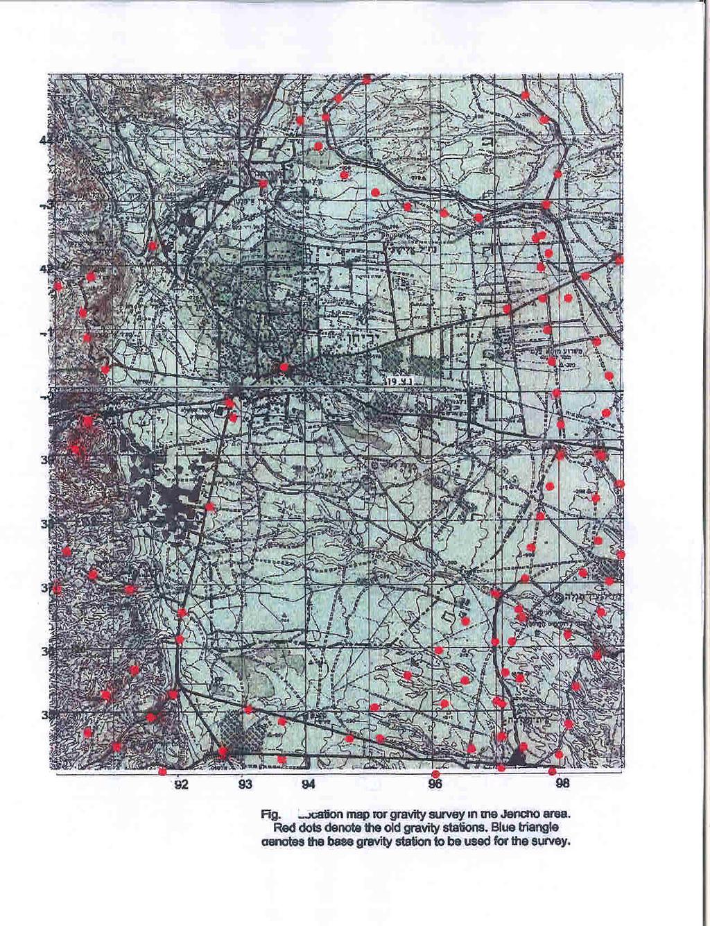
2 The first joint geophysical survey by Israel and the Palestinian Authority was carried out in February 1999 in the vicinity of Jericho. Jericho is located within the Dead Sea Rift valley about 10 km north of the Dead Sea shore. 102 new gravity stations were measured jointly by the authors in order to fill a gap in the existing gravity network (Figs. 1 and 2). The data were processed and incorporated into the joint Gravity Data Base for Israel and Jordan. The project was funded by US-AID project #TA-MOU-96-C with additional funds from An-Najah University, the Geophysical Institute of Israel, and the U.S. Geological Survey. DAT ACQUISITION IN THE JERICHO AREA The gravity survey was performed in the Jericho area and vicinity (Fig. 2). Field measurements were carried out using a Lacoste and Romberg Model G gravimeter (#833). 102 new gravity stations were measured in order to fill the gap in the existing gravity network. The Beit Ha'arava base gravity station was used for the survey. Base stations were occupied at the beginning and end of each working day. During the field survey, the daily drift was usually less than 1 mgal. Bouguer anomaly accuracy, estimated on the basis of repeated measurements (about 5%) at a given station, was 0.26 meal. Gravity station spacing was in the order of 500 meters. The Geographic Positioning System (GPS) was used for geodetic measurements. The gravity stations were positioned using new GPS ProMARK X-CP instruments manufactured by the Magellan Systems Corporation. These instruments were used in the stationary differential 3-D mode. Pseudorange and carrier phase satellite data, collected on the control and remote stations at one-second intervals, were processed using the MSTAR differential post-processing system. The elevation accuracy, estimated on a number of repeated measurements and known benchmarks, is

3 better than 20 centimeters. This accuracy can be obtained by using a multipath-resistant antenna for the following conditions: remote control station distance should be less than 10 km and occupation time about ten minutes. The raw gravity data were reduced using several standard procedures. The latitude correction was calculated according to the 1967 Geodetic Reference System Formula. The gravity data were reduced using 2.67 glcm density. The terrain correction was calculated using relief in the form of a digital terrain model with a 25 meter grid, adopted from the Digital Terrain Model (DTM) compiled by J.K. Hall (Hall, 1993). PRELIMINARY RESULTS The results of the gravity survey are presented in the Bouguer gravity map of the Jericho area (Fig. 3). The Bouguer gravity map shows that the regional trend decreases significantly eastward. This trend, caused by the Dead Sea graben filled by very thick low-density young sediments, may reach the horizontal gravity gradient of up to 10 mgal/km in an east-west direction. The regional gravity trend calculated as a third order polynomial (Fig. 4) was removed when compiling the residual gravity map (Fig. 5). These results will be incorporated into the joint Israel-Jordanian gravity data base for the Dead Sea Rift and its vicinity that was established during US-AID project #TA-MOU-96-C In particular, they will be incorporated into an updated gravity map of the region that will replace the present 1:250,000 map (ten Brink et al., 1998).
 completed. In: R. Bogoch and Y. Eshet (eds.")
4 ACKNOWLEDGMENTS The authors wish to thank Dr. J. Hall for permission and helping to use the DTM, and Mr. Uri Roth for field asistance. This work was partially supported by US-AID grant TA-MOU-96- C REFERENCES Hall, J. K., The GSI Digital Terrain Model (DTM) completed. In: R. Bogoch and Y. Eshet (eds.), GSI Current Research: V., Jerusalem, ten Brink, U., Rybakov, M., Al-Zoubi, A., Hassouneh, M., Batayneh, A., Frieslander, U., Goldschmidt, V., Daoud, M., and Rotstein, Y., 1998, Bouguer gravity anomaly map of the Dead Sea transform plate boundary in Israel and Jordan, scale 1:250,000, USGS open-file report,
5
.")
6 Fig. 2 Gravity coverage map of the Jericho area superimposed on the shadow relief (after MI, 1983). Black dots donab the new gravity stations, white -old.


7 Fig. 3. Bouguer gravity map of the Jerjcho area. Corrbut intenrsl-2 mgal.

8 km Fii. 4. Reg'i gravsty tmnd of the Jericho erea (3-d order polinom).

9 Fig. 5. Residual gravity map of the Jericho area. Corrta# intmmi-1 mgd.
GRAVIMETRIC MAP OF CHILE. Services Mining and Engineering Geophysics Instituto Geográfico Militar
 GRAVIMETRIC MAP OF CHILE Araneda M., Rivas L., Avendaño M, Sottolichio G., Rubio W. Services Mining and Engineering Geophysics segmi@netexpress.cl) Instituto Geográfico Militar (lrivas@igm.cl) Abstract
GRAVITY AND MAGNETIC SURVEY NECHAKO BASIN STUDY ACQUISITION AND PROCESSING PHASE
 GRAVITY AND MAGNETIC SURVEY NECHAKO BASIN STUDY ACQUISITION AND PROCESSING PHASE Report prepared for the B.C. Ministry of Energy and Mines Resource Development Division New Ventures Branch by Bemex Consulting
Gravity data reduction
 Gravity data reduction REDUCTION: raw data à gravity anomaly data Temporal corrections tides and instrument drift Spatial corrections latitude and elevation GRS67 = gravity variation with latitude at sea
GRAVITY SURVEY TEELS MARSH PROSPECT
 GRAVITY SURVEY over the TEELS MARSH PROSPECT MINERAL COUNTY, NV for Dajin Resources (US) Corp. March 2015 SUBMITTED BY Magee Geophysical Services LLC 465 Leventina Canyon Road Reno, Nevada 89523 USA TEL
Magnetic and Gravity Methods for Geothermal Exploration
 Magnetic and Gravity Methods for Geothermal Exploration Dr. Hendra Grandis Geophysics - ITB method and survey procedure Aero- or ground magnetic (covers a large area) Schlumberger resistivity mapping and
Town of Chino Valley. Survey Control Network Report. mgfneerhg mc N. Willow Creek Road Prescott AZ
 Town of Chino Valley Survey Control Network Report mgfneerhg mc. 2050 N. Willow Creek Road Prescott AZ 86301 928-771-2376 Page 1 of 70 Table of Contents Town of Chino Valley Survey Datum Outline A short
Total gravitational field is sum of contributions from all masses.
 Gravity force (acceleration) vs potential (energy) acceleration (g) => GM/r 2 Potential => - GM/r G is Newton s gravitational constant 6.67x10⁻¹¹ (S.I. units) you should determine what the S.I. units are
Determination of Subsurface Bulk Density Distribution for Geotechnical Investigation using Gravity Technique
 Journal of Earth Sciences and Geotechnical Engineering, vol. 7, no.2, 2017, 63-69 ISSN: 1792-9040 (print), 1792-9660 (online) Scienpress Ltd, 2017 Determination of Subsurface Bulk Density Distribution
Development of a Borehole Gravity Meter for Mining Applications
 Ground and Borehole Geophysical Methods Paper 111 Development of a Borehole Gravity Meter for Mining Applications Seigel, H. O. [1], Nind, C. [1], Lachapelle, R. [1], Chouteau, M. [2], Giroux, B. [2] 1.
QUALITATIVE INTERPRETATION OF POTENTIAL FIELD PROFILES: SOUTHERN NECHAKO BASIN
 QUALITATIVE INTERPRETATION OF POTENTIAL FIELD PROFILES: SOUTHERN NECHAKO BASIN By Melvyn E. Best Bemex Consulting International 5288 Cordova Bay Road Victoria, B.C. V8Y 2L4 KEYWORDS: potential fields,
KEYSTONE PROPERTY GRAVITY GIS DATABASE. Residual Gravity Looking Down to Northwest
 KEYSTONE PROPERTY GRAVITY - 2018 GIS DATABASE Residual Gravity Looking Down to Northwest James L. Wright M.Sc. May 11, 2018 TABLE OF CONTENTS INTRODUCTION......................... 2 SURVEY PROCEDURE......................
2.2 Gravity surveys. Gravity survey
 2.2 Gravity surveys Gravity survey The effect of latitude The effect of elevation The Bouguer effect Topographic effect The effect of tides Summary of corrections Gravity in boreholes Gravity survey In
Preliminary Microgravity Measurement Of Paka Geothermal Prospect
 Preliminary Microgravity Measurement Of Paka Geothermal Prospect Presented by: Levi Shako and Calistus Ndongoli Date: 4/November/2016 Venue: Addis Ababa, Ethiopia Introduction Microgravity is a geophysical
440 Geophysics: Fieldtrip guide for Death Valley, April 2005
 440 Geophysics: Fieldtrip guide for Death Valley, April 2005 Thorsten Becker; Jeff Hoeft University of Southern California Objective We will be performing a gravity and several seismic surveys from Friday
Gravity in the Ryukyu Arc*
 Journal of the Geodetic Society of Japan Vol. 22, No. 1, (1976), pp. 23-39 Gravity in the Ryukyu Arc* Jiro SEGAWA Ocean Research Institute, University of Tokyo (Received March 31, 1976; Revised May 22,
HIMALAYAN AIRBORNE GRAVITY AND GEOID OF NEPAL
 Mt. Everest HIMALAYAN AIRBORNE GRAVITY AND GEOID OF NEPAL -Niraj Manandhar Head, Geodetic Survey Branch Survey Department, Geodetic Survey Branch Project Background Air Borne Gravity Survey Project was
Density structure inferred from gravity anomalies in the eastern area of the Itoigawa-Shizuoka Tectonic Line, central Japan
 Earth Planets Space, 56, 1309 1314, 2004 Density structure inferred from gravity anomalies in the eastern area of the Itoigawa-Shizuoka Tectonic Line, central Japan Masao Komazawa National Institute of
Lab 9: Satellite Geodesy (35 points)
") Lab 9: Satellite Geodesy (35 points) Here you will work with GPS Time Series data to explore plate motion and deformation in California. This lab modifies an exercise found here: http://www.unavco.org:8080/cws/pbonucleus/draftresources/sanandreas/
Lab 9: Satellite Geodesy (35 points) Here you will work with GPS Time Series data to explore plate motion and deformation in California. This lab modifies an exercise found here: http://www.unavco.org:8080/cws/pbonucleus/draftresources/sanandreas/
Case study of Japan: Reference Frames in Practice
 Case study of Japan: Reference Frames in Practice Basara Miyahara and Koji Matsuo Sponsors: 1 Outline Introduction - Geodetic reference frame of Japan - GEONET : continuous GNSS observation system Geometric
Hazard Mapping Along the Dead Sea Shoreline
 FIG Working Week in Marrakech, Morocco 18-22 May 2011 Hazard Mapping Along the Dead Sea Shoreline Rami Al-Ruzouq, Abdullah Al-Zuobi, AbdEl-Rahman Abueladas, Emad Akkawi Department of Surveying and Geomatics
GRAVITY EXPLORATION (Gph 301) Chokri Jallouli 2014/2015
 Chokri Jallouli 2014/2015") KING SAUD UNIVERSITY FACULTY OF SCIENCES Department of Geology and Geophysics GRAVITY EXPLORATION (Gph 301) Chokri Jallouli 2014/2015 INTRODUCTION Definition Gravity method consists of measuring, studying
KING SAUD UNIVERSITY FACULTY OF SCIENCES Department of Geology and Geophysics GRAVITY EXPLORATION (Gph 301) Chokri Jallouli 2014/2015 INTRODUCTION Definition Gravity method consists of measuring, studying
The first high-precision gravimetric geoid of Hungary: HGG2013
 Server on Geodesy, Seismology and Environmental Sciences Published Online 2013 (http://airy.ual.es/) The first high-precision gravimetric geoid of Hungary: HGG2013 Abstract V. Corchete Higher Polytechnic
Introduction to the use of gravity measurements in Ge111A
 Introduction to the use of gravity measurements in Ge111A Background & basic intuition Data reduction Use of the instrument See Reynolds for detailed quantitative discussion What and Why Gravity measures
Airborne gravity gradiometer surveying of petroleum systems under Lake Tanganyika, Tanzania
 Airborne gravity gradiometer surveying of petroleum systems under Lake Tanganyika, Tanzania D. Roberts Beach Energy P. Roy Chowdhury CGG S. J. Lowe CGG A. N. Christensen CGG Outline Introduction Geology
Sinkholes along the Dead Sea Coast and their Development. Boris SHIRMAN and Michael RYBAKOV
 Sinkholes along the Dead Sea Coast and their Development Boris SHIRMAN and Michael RYBAKOV Over the past several years, the coastal area around the declining Dead Sea has undergone a catastrophic collapse.
Tell uric prof i 1 es across the Darrough Known Geothermal Resource Area, Nevada. Harold Kaufniann. Open-file Report No.
 Tell uric prof i 1 es across the Darrough Known Geothermal Resource Area, Nevada c i 4 L BY D Harold Kaufniann U.S. Geological Survey. r,. Open-file Report No. 76-286 1976 \, *\. i \ -- i 1'.- - L -.,,-.,
Filippo Galimberti 1 & Simona Sanvito 2
 Filippo Galimberti 1 & Simona Sanvito 2 1 Elephant Seals Research Group 2 Dept. of Biology, Memorial University of Newfoundland Research on elephant seals of the San Benitos Islands Annual Report 2004-2005
a z41. COMMONWEALTH OF AUSTRALIA DEPARTMENT OF NATIONAL DEVELOPMENT BUREAU OF MINERAL RESOURCES, GEOLOGY AND GEOPHYSICS RECORD 1961 No.
 a z41. COMMONWEALTH OF AUSTRALIA ff..4 *.re /Veis DEPARTMENT OF NATIONAL DEVELOPMENT BUREAU OF MINERAL RESOURCES, GEOLOGY AND GEOPHYSICS RECORD 1961 No. 66 RED TANK BORE GRAVITY SURVEY, PLENTY RIVER, N.T.
Darnley Bay Resources Preliminary Airborne Survey Results
 4 King Street West, Suite 1103 Toronto, Ontario M5H 1B6, Canada Tel:(416) 862-7885 Fax:(416) 862-7889 dbr@darnleybay.com UPDATE Trading Symbol: DBL. TSX Venture Exchange April 19, 2010 Darnley Bay Resources
Positional Accuracy of the Google Earth Imagery In The Gaza Strip
 Positional Accuracy of the Google Earth Imagery In The Gaza Strip Maher A. El-Hallaq Associate Professor of Surveying Civil Engineering Department The Islamic University of Gaza, Palestine mhallaq@iugaza.edu.ps
A Case Study of High-Resolution Gravity and Wenner-Schlumberger Resistivity for Geotechnical Engineering: An Example from North Jordan
 Research Journal of Applied Sciences, Engineering and Technology 5(4): 1377-1382-, 2013 ISSN: 2040-7459; e-issn: 2040-7467 Maxwell Scientific Organization, 2013 Submitted: July 09, 2012 Accepted: August
Precise Hong Kong Geoid HKGEOID-2000
 Yong-Qi Chen 1, Zhicai Luo 1 and Simon Kwok 2 1.Department of Land Surveying and Geo-Informatics, The Hong Kong olytechnic University 2 Geodetic Survey Section, Lands Department, HKSAR Abstract: This paper
OUTLINE. Many of us secretly dream of six months without gravity COURSE DESCRIPTION
 GEOL 481.3 OUTLINE POTENTIAL FIELD METHODS GEOL 481.3 email: jim.merriam@usask.ca POTENTIAL FIELD METHODS Many of us secretly dream of six months without gravity Allan Fotheringham COURSE DESCRIPTION This
Gravity Methods (IV)
") Environmental and Exploration Geophysics II Gravity Methods (IV) tom.h.wilson tom.wilson@mail.wvu.edu Department of Geology and Geography West Virginia University Morgantown, WV Possible employment opportunities
Environmental and Exploration Geophysics II Gravity Methods (IV) tom.h.wilson tom.wilson@mail.wvu.edu Department of Geology and Geography West Virginia University Morgantown, WV Possible employment opportunities
 SHEET TITLE: DRAWN BY: J.M.CLARK FILE NO. CHECKED BY: W.S. JORDAN APPROVED BY: DATE: FIGURE SHEET TITLE: DRAWN BY: J.M.CLARK FILE NO. CHECKED BY: W.S. JORDAN APPROVED BY: DATE: FIGURE SPOTLIGHT Technical
GRAVITY AND MAGNETIC METHODS
 Presented at Short Course IX on Exploration for Geothermal Resources, organized by UNU-GTP, GDC and KenGen, at Lake Bogoria and Lake Naivasha, Kenya, Nov. 2-24, 2014. Kenya Electricity Generating Co.,
GM 1.4. SEG/Houston 2005 Annual Meeting 639
 storage recovery project in Leyden, Colorado Kristofer Davis *, Yaoguo Li, Michael Batzle, and Bob Raynolds** Center for Gravity, Electrical, and Magnetic Studies, Department of Geophysics, Colorado School
Estimation of Subsurface Structure in the Western Fukuoka City fromgravity Data
 Available online at www.sciencedirect.com Procedia Earth and Planetary Science 6 ( 2013 ) 163 168 Estimation of Subsurface Structure in the Western Fukuoka City fromgravity Data 1Taiki ARIMA, 2 Yasuhiro
Novel Application in Determining Oil Shale Porosity Using a Borehole Gravimeter
 Novel Application in Determining Oil Shale Porosity Using a Borehole Gravimeter Shell Exploration & Production Katia Pronina Robert Pimentel Matt Holman (presenter) 3/17/2010 File Title Copyright: SIPC
HORIZONTAL PROJECTION PARAMETERS: DANE COUNTY COORDINATES
 Recommended RTK GPS Configuration Parameters for the City of Madison, WI Base Station Compiled by: Dan Rodman RLS, City of Madison (608)266-6674 drodman@cityofmadison.com For base station information see
This Land Surveying course has been developed by Failure & Damage Analysis, Inc.
 This Land Surveying course has been developed by Failure & Damage Analysis, Inc. www.discountpdh.com DEPARTMENT OF THE ARMY U.S. Army Corps of Engineers CECW-EP Washington, DC 20314-1000 ETL 1110-1-183
Title. Author(s)YOKOYAMA, Izumi; SAITO, Tatsuki. Issue Date Doc URL. Type. File Information
YOKOYAMA, Izumi; SAITO, Tatsuki. Issue Date Doc URL. Type. File Information") Title Preliminary report on a Gravimetric Survey on Volcan Author(s)YOKOYAMA, Izumi; SAITO, Tatsuki CitationJournal of the Faculty of Science, Hokkaido Universi Issue Date 1965-03-20 Doc URL http://hdl.handle.net/2115/8665
Title Preliminary report on a Gravimetric Survey on Volcan Author(s)YOKOYAMA, Izumi; SAITO, Tatsuki CitationJournal of the Faculty of Science, Hokkaido Universi Issue Date 1965-03-20 Doc URL http://hdl.handle.net/2115/8665
Three-dimensional geophysical modelling of the Alalobeda geothermal field
 Three-dimensional geophysical modelling of the Alalobeda geothermal field Daniele Rizzello 1, Egidio Armadillo 2, Claudio Pasqua 2,3, Massimo Verdoya 2, Solomon Kebede 4, Andarge Mengiste 4, Getenesh H/Giorgis
Blind fault Configuration in Osaka, Japan based on 2D gravity inversion
 Blind fault Configuration in Osaka, Japan based on 2D gravity inversion N. Inoue & N. Kitada Geo-research Institute, Osaka, Japan K. Takemura Institute for Geothermal Sciences, Kyoto University, Beppu,
on the COMINCO LTD. WESTERN DISTRICT EXPLORATION N.T.S. 94L/3E GEOPHYSICAL SURVEYS LATITUDE: 58' 12' N; LONGITUDE: 127' 10' W
 COMNCO LTD. EXPLORATON N.T.S. 94L/3E WESTERN DSTRCT GEOPHYSCAL SURVEYS on the WEST GROUP, FROG RVER PROPERTY KECHKA AREA, LARD MNNG DVSON, B.C. LATTUDE: 58' 12' N; LONGTUDE: 127' 10' W WORK PERFORMED:
REGIONAL GEOPHYSICS RESEARCH GROUP. Technical Report WK/91/2. Regional Geophysics Series
 British Geological Survey REGIONAL GEOPHYSICS RESEARCH GROUP Technical Report WK/91/2 Regional Geophysics Series Regional infill gravity survey in north-east Antrim, Northern Ireland J P Busby j Natural
PROJECT PROGRESS REPORT (03/lfi?lfibr-~/15/1998):
:") F?ECEVVEI) N% 05 w PROJECT PROGRESS REPORT (03/lfi?lfibr-~/15/1998): A COMPREHENSIVE STUDY OF FRACTURE PATTERNS AND DENSITIES IN THE GEYSERS GEOTHERMAL RESERVOIR USING MICROEARTHQUAKE SHEAR-WAVE SPLITTING
F?ECEVVEI) N% 05 w PROJECT PROGRESS REPORT (03/lfi?lfibr-~/15/1998): A COMPREHENSIVE STUDY OF FRACTURE PATTERNS AND DENSITIES IN THE GEYSERS GEOTHERMAL RESERVOIR USING MICROEARTHQUAKE SHEAR-WAVE SPLITTING
Gravimetric Tide observation at Lake Nasser Region, Aswan, Egypt
 Gravimetric Tide observation at Lake Nasser Region, Aswan, Egypt R.M. Hassan, E.M. Abdelrahman, A. Tealeb, K.H. Zahran and G. Jentzsch ABSTRACT The LaCoste and Romberg gravimeter D-218 of the National
LOST1 TOPPOGMHIC ELEVATIONS FOR THE DEATH VALLEY EGION 01:SOUTHERN NEVADA AND ELEVATION M O W DATA FILES DIGITAL EWATIQN MODEL (DEM) FILE OF
 FILE OF") DIGITAL EWATIQN MODEL (DEM) FILE OF TOPPOGMHIC ELEVATIONS FOR THE DEATH VALLEY EGION 01:SOUTHERN NEVADA AND SOWTI-EWTEWCALIFORNIA PROCESSED FRC E 1 V ED U S GEOLOGICAL SURVEY 1-DEGREE DIGITAL MR2 9 1396
DIGITAL EWATIQN MODEL (DEM) FILE OF TOPPOGMHIC ELEVATIONS FOR THE DEATH VALLEY EGION 01:SOUTHERN NEVADA AND SOWTI-EWTEWCALIFORNIA PROCESSED FRC E 1 V ED U S GEOLOGICAL SURVEY 1-DEGREE DIGITAL MR2 9 1396
PGM2016: A new geoid model for the. Philippines
 PGM2016: A new geoid model for the Philippines United Nations/Nepal Workshop on the Applications of Global Navigation Satellite Systems Kathmandu, Nepal December 12-16, 2016 Ronaldo Gatchalian, Chief Geodesy
Observation of Landslide Movements by Geodetic and Borehole Tilt Measurements
 53 Observation of Landslide Movements by Geodetic and Borehole Tilt Measurements Mentes, Gy. and László Bányai, L. Geodetic and Geophysical Institute, Research Centre for Astronomy and Earth Sciences,
Introduction to the use of gravity measurements
 Introduction to the use of gravity measurements Background & basic intuition Data reduction Use of the instrument See Reynolds, Chpt 2, for detailed quantitative discussion What and Why Gravity measures
4 Survey Datums. 4.1 Horizontal Datum Policy SURVEY DATUMS SEPTEMBER 2006
 4 Survey Datums Today s multi-organizational Project Development efforts require the use of common, accurate horizontal and vertical survey datums and consistent, precise control-survey procedures to ensure
Final Report. January Prof. Dr. Olivier Francis
 ABSOLUTE AND RELATIVE GRAVITY MEASUREMENTS IN NUUK (GREENLAND) IN JULY 2005 Final Report January 2006 Prof. Dr. Olivier Francis University of Luxembourg Faculty of Sciences, Technology and Communication
Valley-Fill Sandstones in the Kootenai Formation on the Crow Indian Reservation, South-Central Montana
 DE-FG22-96BC14996--06 Valley-Fill Sandstones in the Kootenai Formation on the Crow Indian Reservation, South-Central Montana Quarterly Report October 1 - December 31, 1997 By David A. Lopez Work Performed
Geographic Information Systems class # 1 February 19, Coordinate reference systems in GIS: geodetic coordinates
 Geographic Information Systems class # 1 February 19, 2013 Coordinate reference systems in GIS: geodetic coordinates Manuel Campagnolo ISA Manuel Campagnolo (ISA) GIS/SIG 2012 2013 February 19, 2013 1
Height systems. Rüdiger Gens
 Rüdiger Gens 2 Outline! Why bother about height systems?! Relevant terms! Coordinate systems! Reference surfaces! Geopotential number! Why bother about height systems?! give a meaning to a value defined
Valley-Fill Sandstones in the Kootenai Formation on the Crow Indian Reservation, South-Central Montana
 DE-FG22-96BC14996--08 Valley-Fill Sandstones in the Kootenai Formation on the Crow Indian Reservation, South-Central Montana Quarterly Report April 1 - June 30, 1998 By David A. Lopez Work Performed Under
mdu G = Fdr = mgdr Dr. Clint Conrad POST 804 Gravity, the Geoid, and Mantle Dynamics Lecture: Gravity and the Geoid U G = G M r
 GG 611 Big Gulp Fall 2014 Gravity, the Geoid, and Mantle Dynamics Lecture: Gravity and the Geoid Dr. Clint Conrad POST 804 clintc@hawaii.edu Gravitational Potential For a point mass: Newton s law of gravitation:
COPPER KING PROPERTY GROUND MAGNETIC SURVEY GIS DATABASE. Ground Magnetic Survey Preliminary Interpretation
 COPPER KING PROPERTY GROUND MAGNETIC SURVEY GIS DATABASE Ground Magnetic Survey Preliminary Interpretation James L. Wright M.Sc. July 18, 2017 TABLE OF CONTENTS INTRODUCTION......................... 2
OZ SEEBASE TM. Datasets. Digital Elevation Model
 Digital Elevation Model 10 Digital Elevation Models (DEM s) often show the youngest structures, and any active geological structures. They are widely used for neotectonic analysis. The composition of eroding
Integrated Interpretation of Gravity, Magnetic & Seismic data for delineation of Basement Configuration in Sadiya Block, Upper Assam, India
 P-225 Integrated Interpretation of Gravity, Magnetic & Seismic data for delineation of Basement Summary G.K.Ghosh *, S.K.Basha, V.K. Kulshreshth Gravity and magnetic data were collected jointly by National
Gravity-Magnetic & Magneto-Telluric surveys in Purnea Onland Basin, India - A case history.
 P-281 Gravity-Magnetic & Magneto-Telluric surveys in Purnea Onland Basin, India - A case history. Summary A.K. Roy, D.P. Paine*, S. Sett, and H.N. Bhattacharya, ONGC This paper describes a case history
Crustal structure of the southern Dead Sea basin derived from project DESIRE wide-angle seismic data
 Geophys. J. Int. (2009) 178, 457 478 doi: 10.1111/j.1365-246X.2009.04161.x Crustal structure of the southern Dead Sea basin derived from project DESIRE wide-angle seismic data J. Mechie, 1 K. Abu-Ayyash,
Geothermal Energy Resources Exploration using Gravity and magnetics. By Mariita, N.O. KenGen
 Geothermal Energy Resources Exploration using Gravity and magnetics By Mariita, N.O. KenGen What is Geothermal Energy? Geothermal Energy = heat from the Earth Transmitted by fluids via fractures and pores
Activities in South America: Gravity and Geoid Projects
 Activities in South America: Gravity and Geoid Projects Segundo Taller de Grupo de Trabajo I SIRGAS Montevideo - Uruguay May 26 a 30, 2008 Maria Cristina Pacino Universidade de Rosário CGED - IBGE Denizar
Choosing the wrong spheroid
 Reality Check The E&P industry has experienced avoidable costs in its encounters with the science and methodology of geodesy and cartography. The following are explicit case histories of real problems
Gravity reduction spreadsheet to calculate the Bouguer anomaly using standardized methods and constants
 Gravity reduction spreadsheet to calculate the Bouguer anomaly using standardized methods and constants Derek I. Holom John S. Oldow Department of Geological Sciences, University of Idaho, Moscow, Idaho
D DAVID PUBLISHING. Towards a New Geoid Model of Tanzania Using Precise Gravity Data. 1. Introduction. Selassie David Mayunga
 Journal of Environmental Science and Engineering A 5 (2016) 267-276 doi:10.17265/2162-5298/2016.05.005 D DAVID PUBLISHING Towards a New Geoid Model of Tanzania Using Precise Gravity Data Selassie David
U.S. DEPARTMENT OF THE INTERIOR U.S. GEOLOGICAL SURVEY MEASUREMENTS OF SAND THICKNESSES IN GRAND CANYON,
 U.S. DEPARTMENT OF THE INTERIOR U.S. GEOLOGICAL SURVEY MEASUREMENTS OF SAND THICKNESSES IN GRAND CANYON, ARIZONA, AND A CONCEPTUAL MODEL FOR CHARACTERIZING CHANGES IN SAND-BAR VOLUME THROUGH TIME AND SPACE
PRELIMINARY INVESTIGATIONS OF SUBSIDENCE, COLLAPSE, AND POTENTIAL FOR CONTINUED GROWTH OF THE DAISETTA SINKHOLE, LIBERTY COUNTY, TEXAS
 PRELIMINARY INVESTIGATIONS OF SUBSIDENCE, COLLAPSE, AND POTENTIAL FOR CONTINUED GROWTH OF THE DAISETTA SINKHOLE, LIBERTY COUNTY, TEXAS by Jeffrey G. Paine 1, Edward W. Collins 1, Clark R. Wilson 2, and
ENVI.2030L - Plate Tectonics - Geomagnetism, Earthquakes, and Gravity
 I. Geomagnetism Name ENVI.2030L - Plate Tectonics - Geomagnetism, Earthquakes, and Gravity The earth's magnetic field can be viewed as a simple bar magnet located near the center of the earth and inclined
Precision Gravimetry in the New Zugspitze Gravity Meter Calibration System
 Precision Gravimetry in the New Zugspitze Gravity Meter Calibration System J. Flury, T. Peters, M. Schmeer Institute for Astronomical and Physical Geodesy (IAPG), Technische Universität München, 80290
Bonn, Germany MOUTAZ DALATI. General Organization for Remote Sensing ( GORS ), Syria Advisor to the General Director of GORS,
, Syria Advisor to the General Director of GORS,") Bonn, Germany Early Warning System is needed for Earthquakes disaster mitigation in Syria Case Study: Detecting and Monitoring the Active faulting zones along the Afro-Arabian-Syrian Rift System MOUTAZ
Bonn, Germany Early Warning System is needed for Earthquakes disaster mitigation in Syria Case Study: Detecting and Monitoring the Active faulting zones along the Afro-Arabian-Syrian Rift System MOUTAZ
Height systems. Rudi Gens Alaska Satellite Facility
 Rudi Gens Alaska Satellite Facility Outline Why bother about height systems? Relevant terms Coordinate systems Reference surfaces Geopotential number 2 Why bother about height systems? give a meaning to
ABSOLUTE GRAVITY MEASUREMENTS
 ABSOLUTE GRAVITY MEASUREMENTS AT THE CONRAD OBSERVATORIUM IN AUSTRIA IN JUNE 2012 Final Report August 2012 Prof. Dr. Olivier Francis University of Luxembourg Faculty of Sciences, Technology and Communication
B. Topographic maps are also called. contour maps
 Topographic Maps Introduction A. Topographic maps are essential tools in geologic and engineering studies because they show the configuration of Earth's surface in remarkable detail and permit one to measure
USING LIDAR MEASUREMENTS FOR IMPROVING OR UP-DATING A DEM
 JAES_1(14)_3_2011 VAIS M. et. all, pp.123-128 SECTION Geodesic Engineering USING LIDAR MEASUREMENTS FOR IMPROVING OR UP-DATING A DEM VAIS Manuel*, IOSIF Gheorghe, Bucharest University, *e-mail: manuel.vais@sipg.ro
The 11 th February, 2004 Earthquake of The Dead Sea, Jordan
 American Journal of Environmental Sciences 1 (2): 142-148, 2005 ISSN 1553-345X 2005 Science Publications The 11 th February, 2004 Earthquake of The Dead Sea, Jordan Abdallah S. Al-Zoubi Faculty of Engineering,
A Preliminary Attempt of a Quasi-Geoid for Saudi Arabia
 A Preliminary Attempt of a Quasi-Geoid for Saudi Arabia Saad MOGREN, Saudi Arabia Key words: Geoid, Saudi Arabia, SUMMARY This proposal describes the need to undertake a national geoid (quasi-geoid) model
Keywords: geophysics field camp, low to moderate, temperature, geothermal system, Mt Pancar, Indonesia
 Proceedings World Geothermal Congress 2015 Melbourne, Australia, 19-25 April 2015 Geophysics Field Camp (GFC): A Student Project Aimed to Investigate the Low to Moderate Temperature Geothermal System in
BASAL CAMBRIAN BASELINE GEOLOGICAL CHARACTERIZATION COMPLETED
 BASAL CAMBRIAN BASELINE GEOLOGICAL CHARACTERIZATION COMPLETED Plains CO 2 Reduction (PCOR) Partnership Phase III Task 16 Milestone M33 Prepared for: Andrea T. McNemar National Energy Technology Laboratory
Horizontal gradient and band-pass filter of aeromagnetic data image the subsurface structure; Example from Esh El Mellaha Area, Gulf of Suez, Egypt.
 Horizontal gradient and band-pass filter of aeromagnetic data image the subsurface structure; Example from Esh El Mellaha Area, Gulf of Suez, Egypt. Essam Aboud 1, Serguei Goussev 2, Hassan Hassan 2, Suparno
Raster Data Enhancement and Tectonic Element Interpretation in ArcMap
 Raster Data Enhancement and Tectonic Element Interpretation in ArcMap Vsevolod Egorov ESRI Petroleum User Group Conference Houston, TX 2005 Abstract ArcMap Spatial Analyst provides quick, but powerful
A Geological and Geophysical Assessment of the Royal Center Gas Storage Field in North-Central Indiana, a Joint NIPSCO, DOE & GRI Case Study
 A Geological and Geophysical Assessment of the Royal Center Gas Storage Field in North-Central Indiana, a Joint NIPSCO, DOE & GRI Case Study by rne/fe7y5- -* -- 5q7255 Thomas H. Mroz, U.S.DOE/FETC, Morgantown,
GPS Strain & Earthquakes Unit 3: Finding location and velocity data for PBO GPS stations
 GPS Strain & Earthquakes Unit 3: Finding location and velocity data for PBO GPS stations Original activity by Vince Cronin (Baylor University). Revisions by Beth Pratt-Sitaula (UNAVCO). Analyzing the velocities
Part 5: Total stations
 Provläsningsexemplar / Preview INTERNATIONAL STANDARD ISO 17123-5 Third edition 2018-02 Optics and optical instruments Field procedures for testing geodetic and surveying instruments Part 5: Total stations
Geog Lecture 29 Mapping and GIS Continued
 Geog 1000 - Lecture 29 Mapping and GIS Continued http://scholar.ulethbridge.ca/chasmer/classes/ Today s Lecture (Pgs 13-25, 28-29) 1. Hand back Assignment 3 2. Review of Dr. Peddle s lecture last week
CHAPTER FOUR GEOPHYSICAL INTERPRETATION AND DISCUSSION
 CHAPTER FOUR GEOPHYSICAL INTERPRETATION AND DISCUSSION 4.1. DATA PROCESSING AND INTERPRETATION 4.1.1. Introduction Processing of potential field data entails the application of various filters to the data
ESTIMATES OF HORIZONTAL DISPLACEMENTS ASSOCIATED WITH THE 1999 TAIWAN EARTHQUAKE
 ESTIMATES OF HORIZONTAL DISPLACEMENTS ASSOCIATED WITH THE 1999 TAIWAN EARTHQUAKE C. C. Chang Department of Surveying and Mapping Engineering Chung Cheng Institute of Technology, Taiwan, ROC ABSTRACT A
LAMONT-DOHERTY GEOLOGICAL OBERVATORY DATA REDUCTION CRUISE SUMMARY
 LAMONT-DOHERTY GEOLOGICAL OBERVATORY DATA REDUCTION CRUISE SUMMARY " A GLORIA, HYDROSWEEP, geophysical investigation of the Juan Fernandez microplate" PAPEETE, TAHITI - VALPARAISO, CHILE 06/16/91 (JD 167)
MT Prospecting. Map Resistivity. Determine Formations. Determine Structure. Targeted Drilling
 MT Prospecting Map Resistivity Determine Formations Determine Structure Targeted Drilling Cross-sectional interpretation before and after an MT survey of a mineral exploration prospect containing volcanic
GRAVITY SURVAY AT SEA
 GRAVITY SURVAY AT SEA This is a continuation of the report of gravity surveys at sea conducted by the Hydrographic and Oceanographic Department.The results of four surveys made in 1995-2002, Ise Wan, Offing
Geophysical Exploration in Water Resources Assessment. John Mundell, P.E., L.P.G., P.G. Ryan Brumbaugh, L.P.G. Mundell & Associates, Inc.
 Geophysical Exploration in Water Resources Assessment John Mundell, P.E., L.P.G., P.G. Ryan Brumbaugh, L.P.G. Mundell & Associates, Inc. Presentation Objective Introduce the use of geophysical survey methods
Positional accuracy of the drainage networks extracted from ASTER and SRTM for the Gorongosa National Park region - Comparative analysis
 Positional accuracy of the drainage networks extracted from ASTER and SRTM for the Gorongosa National Park region - Comparative analysis Tiago CARMO 1, Cidália C. FONTE 1,2 1 Departamento de Matemática,
G 3. AN ELECTRONIC JOURNAL OF THE EARTH SCIENCES Published by AGU and the Geochemical Society
 Geosystems G 3 AN ELECTRONIC JOURNAL OF THE EARTH SCIENCES Published by AGU and the Geochemical Society Article Volume 7, Number 9 28 September 2006 Q09012, doi:10.1029/2005gc001229 ISSN: 1525-2027 Small-scale
r 1 r 2 r 3 Dr is what matters!
 Today s Agenda Gravity - Background & basic intuition - Data reduction - Use of the instrument - See textbook for detailed quantitative discussion - Measure height of Millikan or S. Mudd What and Why Gravity
Summary. Study Area. Data Acquisition
 Evidence for hyper-extended continental crust in the East Orphan Basin from seismic reflection data and potential field forward modelling and inversion J. Kim Welford 1, Deric Cameron 2, James Carter 2
Application of Remote Sensing and GIS in Seismic Surveys in KG Basin
 P-318 Summary Application of Remote Sensing and GIS in Seismic Surveys in KG Basin M.Murali, K.Ramakrishna, U.K.Saha, G.Sarvesam ONGC Chennai Remote Sensing provides digital images of the Earth at specific
Detailed Gravity and Magnetic Survey of the Taylorsville Triassic Basin
 Detailed Gravity and Magnetic Survey of the Taylorsville Triassic Basin Technical Progress Report Report Period 6/2/97 to 12/31/97 Dr. John Leftwich, Project Director Dr. Ali A. Nowroozi, Co-Principal