Final Report. January Prof. Dr. Olivier Francis
|
|
|
- Antonia Lane
- 5 years ago
- Views:
Transcription

1 ABSOLUTE AND RELATIVE GRAVITY MEASUREMENTS IN NUUK (GREENLAND) IN JULY 2005 Final Report January 2006 Prof. Dr. Olivier Francis University of Luxembourg Faculty of Sciences, Technology and Communication Campus Kirchberg 6, rue Coudenhove-Kalergi L-1359 Luxembourg Grand-Duché de Luxembourg Tel. : , olivier.francis@uni.lu 0
2 Foreword This report contains the results of absolute and relative gravity measurements carried out in Nuuk (Greenland) in July The absolute gravimeter FG5#216 from the European Center for Geodynamics and Seismology was operated by Olivier Francis and Gilbert Klein from the University of Luxembourg. René Forsberg was present and provided assistance and logistic support during the measurements. The relative gravity measurements were carried out with the spring gravimeter Scintrex CG5#008 by the same team. During this campaign, we measured the gravity site previously occupied by the Hannover group in 1988 with a absolute gravimeter Jilag. In addition to the absolute gravity measurements, the vertical and horizontal gravity gradients were measured at the absolute gravity site. We also took part of the gravity survey of a network in and around Nuuk simultaneously with René Forsberg. He was operating a LaCoste-Romberg gravimeter. 1. Absolute Gravity measurements The absolute gravity observations were performed in the basement of the City Hall building in Nuuk. A sketch of the room is displayed in Figure 1. Figure 1. Sketch of the absolute gravity site in the Nuuk City Hall basement. A picture of the set-up of the absolute gravimeter FG5#216 on the site is shown in Figure 2. The gravimeter could not be installed directly above the gravity benchmark because it is to close to the electrical cabinet. 1

3 Figure 2. The FG5#216 from the ECGS at the absolute gravity station of Nuuk. The gravity benchmark is visible on the left side of the FG5. Due its proximity to the electrical cabinet, it was not possible to set-up the FG5 on top of it. 1.1 Data processing Raw data from the absolute gravimeters consist of vectors of time and position of the falling object during the drops. To obtain the gravity value, a linear equation representing the equation of motion is fit to the raw data including the gravity gradient which has been measured with relative meters. The data processing follows the protocol adopted during absolute gravimeters comparisons at the BIPM in Sèvres (Francis and van Dam, 2003). Geophysical corrections are applied to the raw gravity data: Earth tides using observed tidal parameters, atmospheric pressure effect using a constant admittance, and the polar motion effect using pole positions from IERS. The g-soft version 4.0 software from Micro-g Solutions Inc. was used for the processing. All the text outputs as well as some figures are compiled in the annexes of this report for future reference. 1.2 Vertical and Horizontal Gravity Gradient The vertical gravity gradient was measured with a Scintrex. This gradient is needed to linearize the equation of motion but also to transfer the measured absolute gravity value from the reference height around 1.3 m to the floor. We measured a linear vertical gravity gradient of ± microgal/cm. In addition, we measured the gravity difference between the site where the absolute measurements where taken and the gravity benchmark. Its value is 3.1 ± 0.5 microgal as measured with the spring gravimeter. It was impossible to set up the FG5 directly on top of the gravity benchmark because it has been set to close from the electrical panel. 2
4 1.3 Tidal corrections At coastal stations, it is very difficult to model the ocean loading tides due to the proximity of the ocean. We decided to use observed tidal parameters instead of using models for the body and oceanic loading tides. For that purpose, we left the spring gravimeter Scintrex in the Asiaq (Greenland Survey) building in Nuuk to record the gravity tides. At this stage, we analyzed 45 days of data (Figures 3) to extract the observed tidal parameters (Table 1). These have been used for processing the FG5 observations. At the time of this report, the Scintrex is still recording the gravity tides in Nuuk. The recording will be stopped once at least 6 months of observations will be acquired. Figures days of data from the spring gravimeter Scintrex CG5#008 in Nuuk in the Asiaq (Greenland Survey) building. The top figure shows the raw minute data. The bottom one shows the same data after removing a 3 th degree polynomial. 3
 building in Nuuk. For the DC, long-periods, M 3 and M 4 tides, the theoretical values have been used.")

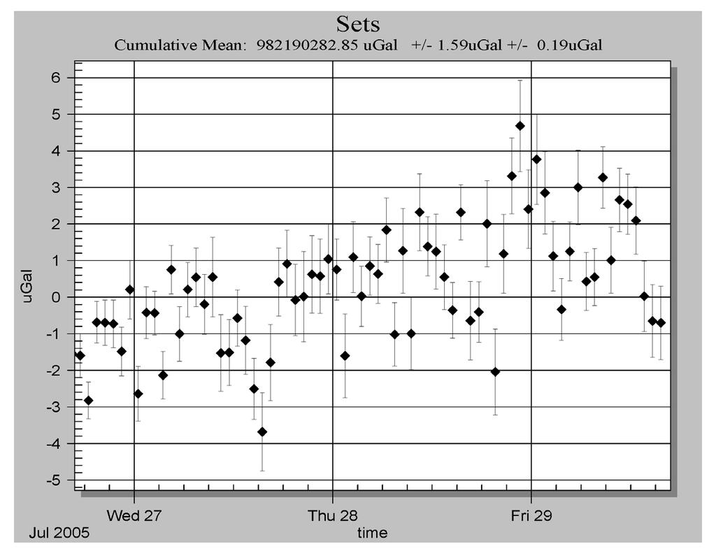
5 Table 1. Observed tidal parameters (delta factor and phase alpha) for Nuuk from the tidal analysis of 45 days of record with a spring gravimeter Scintrex CG5. The gravimeter was installed in the Asiaq (Greenland Survey) building in Nuuk. For the DC, long-periods, M 3 and M 4 tides, the theoretical values have been used. Wave from (cpd) To (cpd) Amplitude Factor Phase Lead (degree) DC Long Periods Q O M K J OO N N M L S M M In Figures 4, one can see the improvement in the absolute gravity data processing by using the observed tidal parameters. Figures 4. Comparison of the set values using the modelled tides on the left side and the observed tidal parameters on the right side. With the observed parameters most of the tidal signal has been removed. We also observe a decrease of the set standard deviation from 2.60 to 1.59 microgal. Moreover we clearly see a slope in the gravity values during the duration of the observation of about 1 microgal/day. 4


6 1.4 Results of the absolute gravity measurements The FG5#216 was set-up on Tuesday 26 th of July until Friday 29 th of July A total of 72 sets of 100 drops were taken with a rate of 1 set per hour. Site Gravity value /microgal Standard Deviation /microgal City Hall - Absolute 1.3 m City Hall Absolute the floor City Hall Gravity Benchmark Relative measurements Gravity ties were measured between different sites (Figures 5) belonging to the local gravity network with our Scintrex CG5. The sites were selected by René Forsberg. City Hall - Bench Mark (78801) City Hall-Flag (78802) City Hall-Absolute site Airport (78206) Harbour (78104) Figures 5. Sites of the relative network measured in Nuuk. 5
7 The results of the gravity ties are given in Table 2. Table 2. Relative ties in Nuuk. Site Code gravity difference/ microgal RMS microgal City Hall - Bench Mark City Hall-Absolute site City Hall-Flag Airport Harbour Reference Francis O., van Dam T.M., Processing of the Absolute data of the ICAG01, Cahiers du Centre Européen de Géodynamique et de Séismologie, vol.22, 45-48,
8 ANNEXES STATION: NUUK City: NUUK Country: Greenland Location: City Hall Particularity: Situation: Basement Remarks: Date: July 2005 Code number: Close to Latitude: degrees Longitude: degrees Elevation: m Gradient: µgal/cm Reference height: m m = 1.299m Meter: FG5 S/N: 216 Tidal corrections using observed tidal parameters Polar motion correction Air pressure correction X-coordinate arc seconds Nominal air pressure: mbar Y-coordinate arc seconds Barometric admittance factor: 0.3 µgal/mbar Gravity Set gravity mean: Microgal Set std. dev.: 1.59 microgal Mean std. dev.: 8.05 microgal Number of sets: 72 Number of drops per set: 100 Drop interval: Set interval: Nominal/datum height: Author: O. Francis 10 seconds 60 minutes 1.30 m European Center for Geodynamics and Seismology Date: November 25,
9 Project file Micro-g Solutions g Processing Report File Created: 11/25/05, 14:05:37 Project Name: nu g Acquisition Version: g Processing Version: Company/Institution: ECGS Operator: Olivier Francis Station Data Name: NUUK Site Code: City Hall Basement Lat: Long: Elev: m Reference Height: cm Datum Height: cm Gradient: ugal/cm Nominal Air Pressure: mbar Barometric Admittance Factor: 0.30 Polar Motion Coord: " " Earth Tide (ETGTAB) Selected Potential Filename: C:\Program Files\Micro-g Solutions Inc\gWavefiles\Etcpot.dat Delta Factor Filename: F:\ABSOLU\DATA\2005\NUUK\nuuk.ini Delta Factors Start Stop Amplitude Phase Term DC Long Q O M K J OO N N M L S M M4 Instrument Data Meter Type: FG5 Meter S/N: 216 Factory Height: cm Rubidium Frequency: Hz Laser: WEO100 (187) ID: nm ( 0.51 V) IE: nm ( 0.15 V) IF: nm ( V) IG: nm ( V) IH: nm ( V) II: nm ( V) IJ: nm ( V) 8
10 Modulation Frequency: Hz Processing Results Date: 07/28/05 Time: 04:01:35 DOY: 209 Year: 2005 Gravity: ugal Set Scatter: 1.59 ugal Measurement Precision: 0.19 ugal Total Uncertainty: 0.19 ugal Number of Sets Collected: 72 Number of Sets Processed: 72 Set #s Processed: 1,2,3,4,5,6,7,8,9,10,11,12,13,14,15,16,17,18,19,20,21,22,23,24,25,26,27,28,29,30,31,32,33,34,35, 36,37,38,39,40,41,42,43,44,45,46,47,48,49,50,51,52,53,54,55,56,57,58,59,60,61,62,63,64,65,66,6 7,68,69,70,71,72 Number of Sets NOT Processed: 0 Set #s NOT Processed: Number of Drops/Set: 100 Total Drops Accepted: 7167 Total Drops Rejected: 33 Total Fringes Acquired: 700 Fringe Start: 20 Processed Fringes: 600 GuideCard Multiplex: 4 GuideCard Scale Factor: 250 Gravity Corrections Earth Tide (ETGTAB): ugal Polar Motion: ugal Barometric Pressure: ugal Datum Height: ugal Reference Xo: ugal Uncertainties Earth Tide Factor: Average Earth Tide Uncertainty: 0.00 ugal Ocean Load Factor: 0.00 Average Ocean Load Uncertainty: 0.00 ugal Barometric: 0.00 ugal Polar Motion: 0.00 ugal Laser: 0.00 ugal Clock: 0.00 ugal System Type: 0.00 ugal Tidal Swell: 0.00 ugal Water Table: 0.00 ugal Unmodeled: 0.00 ugal System Setup: 0.00 ugal Gradient: 0.00 ugal ( 0.00 ugal/cm) Comments: Files Merged: nu fg5 nu fg5 9
11 Set File Source Data Filename: nu g Acquisition Version: g Processing Version: Set Time DOY Year Gravity Sigma Error Uncert Tide Load Baro Polar Datum Refxo Temp Pres Accept Reject 1 16:28: :28: :28: :28: :28: :28: :28: :28: :28: :28: :28: :28: :28: :28: :28: :28: :28: :28: :28: :28: :28: :28: :28: :28: :28: :28: :28: :28: :28: :28: :28: :28: :28:
12 34 01:28: :28: :28: :28: :28: :28: :28: :28: :28: :28: :28: :28: :28: :28: :28: :38: :38: :38: :38: :38: :38: :38: :38: :38: :38: :38: :38: :38: :38: :38: :38: :38: :38: :38: :38: :38: :38: :38: :38:
13 12
14 13
15 14
Absolute and Relative Gravity Measurements at the Istituto Nazionale di Ricerca Metrologica (INRIM) of Turin (Italy) in June 2006
 of Turin (Italy) in June 2006") Absolute and Relative Gravity Measurements at the Istituto Nazionale di Ricerca Metrologica (INRIM) of Turin (Italy) in June 2006 Final Report September 2006 Prof. Dr. Olivier Francis University of Luxembourg
Absolute and Relative Gravity Measurements at the Istituto Nazionale di Ricerca Metrologica (INRIM) of Turin (Italy) in June 2006 Final Report September 2006 Prof. Dr. Olivier Francis University of Luxembourg
Intermediary Report - August Prof. Dr. Olivier Francis and Prof. Dr. Tonie Van Dam
 ABSOLUTE GRAVITY MEASUREMENTS IN YELLOWSTONE IN SEPTEMBER 2009 Intermediary Report - August 2010 Prof. Dr. Olivier Francis and Prof. Dr. Tonie Van Dam University of Luxembourg Faculty of Sciences, Technology
ABSOLUTE GRAVITY MEASUREMENTS
 ABSOLUTE GRAVITY MEASUREMENTS AT THE CONRAD OBSERVATORIUM IN AUSTRIA IN JUNE 2012 Final Report August 2012 Prof. Dr. Olivier Francis University of Luxembourg Faculty of Sciences, Technology and Communication
ABSOLUTE GRAVITY MEASUREMENTS IN LOMONOSOV, SAINT-PETERSBURG, RUSSIA
 ABSOLUTE GRAVITY MEASUREMENTS IN LOMONOSOV, SAINT-PETERSBURG, RUSSIA FINAL REPORT NOVEMBER 2004 Prof. Dr. Olivier Francis University of Luxembourg Faculty of Sciences, Technology and Communication Campus
RELATIVE GRAVITY MEASUREMENTS
 RELATIVE GRAVITY MEASUREMENTS IN KELLYVILLE AND KANGERLUSSUAQ IN JULY 2013 Final Report June 2015 Prof. Dr. Olivier Francis University of Luxembourg Faculty of Sciences, Technology and Communication Campus
RELATIVE GRAVITY MEASUREMENTS
 RELATIVE GRAVITY MEASUREMENTS IN ILULISSAT IN JULY 2013 Final Report June 2015 Prof. Dr. Olivier Francis University of Luxembourg Faculty of Sciences, Technology and Communication Campus Kirchberg 6, rue
Absolute Gravity Observation at the National Measurement Institute
 Record 2013/30 GeoCat 76733 Absolute Gravity Observation at the National Measurement Institute 18th June 2008 Nicholas Dando, Ray Tracey APPLYING GEOSCIENCE TO AUSTRALIA S MOST IMPORTANT CHALLENGES www.ga.gov.au
Intercomparison of Relative and Absolute Gravimeters. Olivier FRANCIS
 Intercomparison of Relative and Absolute Gravimeters Olivier FRANCIS The right gravimeter for the right job (signal to be detected) Absolute/relative Stability (accuracy)/precision (repetability) Spatial
Istituto Nazionale di Ricerca Metrologica
 Istituto Nazionale di Ricerca Metrologica G. D Agostino (1), S. Desogus (1), A. Germak (1), C. Origlia (1), D. Quagliotti (1), G. Celli (2) and O. Francis (3) MEASUREMENTS OF THE ACCELERATION DUE TO GRAVITY
Reservoir Monitoring Using Hybrid Micro-Gravity Measurements in the Takigami Geothermal Field, Central Kyushu, Japan
 Proceedings World Geothermal Congress 2010 Bali, Indonesia, 25-29 April 2010 Reservoir Monitoring Using Hybrid Micro-Gravity Measurements in the Takigami Geothermal Field, Central Kyushu, Japan Jun Nishijima,
FG5 Absolute Gravimeter
 FG5 Absolute Gravimeter Micro-g LaCoste Derek van Westrum, Ph.D. www.microglacoste.com derek@microglacoste.com FG5 Specifications Accuracy: 2 μgal (observed agreement between FG5 instruments) Precision:
Absolute gravimetry. Gabriel Strykowski Geodynamics Department DTU-Space (formerly Danish National Space Center)
") Absolute gravimetry by Gabriel Strykowski Geodynamics Department DTU-Space (formerly Danish National Space Center) gs@space.dtu.dk Contents 1. Instrumentation 2. Absolute gravity measurements: applications
Absolute gravimetry by Gabriel Strykowski Geodynamics Department DTU-Space (formerly Danish National Space Center) gs@space.dtu.dk Contents 1. Instrumentation 2. Absolute gravity measurements: applications
Istituto Nazionale di Ricerca Metrologica
 Istituto Nazionale di Ricerca Metrologica G. D Agostino, S. Desogus, A. Germak, C. Origlia and D. Quagliotti ABSOLUTE MEASUREMENTS OF THE FREE-FALL ACCELERATION g IN PANTELLERIA (ITALY) T.R. 76 November
To the best of our knowledge, the FG5 gravimeter represents the current state-of-the-art in the measurement of absolute gravity.
 FG5 gravity meter To the best of our knowledge, the FG5 gravimeter represents the current state-of-the-art in the measurement of absolute gravity. American Geophysical Union, EOS Journal Since its introduction
Publication 15_H055. Absolute and Relative Gravity Survey University of Hawai i-manoa and Pier 35 Honolulu, Hawai i. February - March 2015
 GEODETIC SURVEYS DIVISION UNCLASSIFIED 314 Publication 15_H055 Absolute and Relative Gravity Survey University of Hawai i-manoa and Pier 35 Honolulu, Hawai i February - March 2015 UNCLASSIFIED 2. NATIONAL
ONE YEAR WITH OUR ABSOLUTE GRAVIMETER
 ONE YEAR WITH OUR ABSOLUTE GRAVIMETER Mikael Lilje, Jonas Ågren, Andreas Engfeldt, Per-Anders Olsson Lantmäteriet, Sweden Introduction In Sweden, a new generation of reference systems has been introduced.
Gravity Monitoring with a Superconducting Gravimeter in Vienna
 1 of 10 2/18/2011 3:30 PM Gravity Monitoring with a Superconducting Gravimeter in Vienna Bruno Meurers Institute of Meteorology and Geophysics, University of Vienna Central Institute of Meteorology and
Istituto Nazionale di Ricerca Metrologica
 Istituto Nazionale di Ricerca Metrologica G. D Agostino, S. Desogus, A. Germak, C. Origlia and D. Quagliotti ABSOLUTE MEASUREMENTS OF THE FREE-FALL ACCELERATION g IN THE REPUBLIC OF PANAMA T.R. 111 March
Gravimetric Tide observation at Lake Nasser Region, Aswan, Egypt
 Gravimetric Tide observation at Lake Nasser Region, Aswan, Egypt R.M. Hassan, E.M. Abdelrahman, A. Tealeb, K.H. Zahran and G. Jentzsch ABSTRACT The LaCoste and Romberg gravimeter D-218 of the National
Absolute Gravity Measurements at Maitri, Antarctica
 Twenty Third Indian Antarctic Expedition Ministry o f Earth Sciences, Technical Publication No. 21, pp 149-154 Absolute Gravity Measurements at Maitri, Antarctica V.M. Tiwari and M.B.S. Vyghreswara Rao
Tidal gravity measurements in Southeast Asia revisited.
 Tidal gravity measurements in Southeast Asia revisited. Olivier Francis and Tonie van Dam Geophysics Laboratory Faculty of Science, Technology and Communication University of Luxembourg Luxembourg Olivier.francis@uni.lu
One Year with Our Absolute Gravimeter
 Mikael LILJE, Jonas ÅGREN, Andreas ENGFELDT and Per-Anders OLSSON, Sweden ABSTRACT In 2006 Lantmäteriet (the National Land Survey of Sweden) bought an absolute gravimeter (Micro-g Lacoste FG5) together
Mount Stromlo Gravity Station Gravimetry at the ANU
 ANU COLLEGE OF SCIENCE RESEARCH SCHOOL OF EARTH SCIENCES Canberra ACT 0200 Australia Mount Stromlo Gravity Station Gravimetry at the ANU Background Terrestrial observing has been conducted at Mount Stromlo
Regional Comparison of Absolute Gravimeters SIM.M.G-K1 Key Comparison
 Final Report Consultative Committee on Mass and Related Quantities (CCM) Working Group on Gravimetry (WGG) Regional Comparison of Absolute Gravimeters SIM.M.G-K1 Key Comparison Table Mountain Geophysical
Development of a Borehole Gravity Meter for Mining Applications
 Ground and Borehole Geophysical Methods Paper 111 Development of a Borehole Gravity Meter for Mining Applications Seigel, H. O. [1], Nind, C. [1], Lachapelle, R. [1], Chouteau, M. [2], Giroux, B. [2] 1.
Hybrid Gravimetry for Optimization Time Lapse Monitoring Data: A case study in Kamojang Geothermal Field
 Proceedings World Geothermal Congress 2015 Melbourne, Australia, 19-25 April 2015 Hybrid Gravimetry for Optimization Time Lapse Monitoring Data: A case study in Kamojang Geothermal Field Yayan Sofyan 1,4,
Geophysical Correction Application in Level 2 CryoSat Data Products
 ESRIN-EOP-GQ / IDEAS IDEAS-VEG-IPF-MEM-1288 Version 2.0 29 July 2014 Geophysical Correction Application in Level 2 CryoSat Data Products TABLE OF CONTENTS 1 INTRODUCTION... 3 1.1 Purpose and Scope... 3
A Preliminary Attempt of a Quasi-Geoid for Saudi Arabia
 A Preliminary Attempt of a Quasi-Geoid for Saudi Arabia Saad MOGREN, Saudi Arabia Key words: Geoid, Saudi Arabia, SUMMARY This proposal describes the need to undertake a national geoid (quasi-geoid) model
Rigorous Combination of Superconducting and Absolute Gravity Measurements with Respect to Instrumental Properties
 Rigorous Combination of Superconducting and Absolute Gravity Measurements with Respect to Instrumental Properties H. Wziontek, R. Falk, H. Wilmes, P. Wolf Bundesamt für Kartographie und Geodäsie (BKG),
ECGN - Development of the European Combined Geodetic Network in Austria
 ECGN - Development of the European Combined Geodetic Network in Austria Diethard Ruess 1, Gelöscht: BEV Dept. Control Survey Abstract Austria takes part in the European Combined Geodetic Network - Project
On Integrated Geodetic Monitoring for Sinkhole-Induced Surface Deformation and Mass Dislocation
 On Integrated Geodetic Monitoring for Sinkhole-Induced Surface Deformation and Mass Dislocation - JISDM2016 - Joint International Symposium on Deformation Monitoring - Session - Multi-Sensor-Systems for
Comparison between measurements with the superconducting gravimeter T020 and the absolute gravimeter FG5-221 at Metsähovi, Finland in
 Comparison between measurements with the superconducting gravimeter T020 and the absolute gravimeter FG5-221 at Metsähovi, Finland in 2003-2012 H. Virtanen,, M. Bilker-Koivula, J. Mäkinen J. Näränen, A.
HARMONIC CONSTANTS Product Specification
 HARMONIC CONSTANTS Product Specification Edition 1.0 Edition 1 November 2006 1 Contents 1. Introduction 1.1 General 1.2 Definitions 2. General Information 2.1 Observation of the Tide 2.2 Harmonic Analysis
Determination of Subsurface Bulk Density Distribution for Geotechnical Investigation using Gravity Technique
 Journal of Earth Sciences and Geotechnical Engineering, vol. 7, no.2, 2017, 63-69 ISSN: 1792-9040 (print), 1792-9660 (online) Scienpress Ltd, 2017 Determination of Subsurface Bulk Density Distribution
GRAVITY SURVEY TEELS MARSH PROSPECT
 GRAVITY SURVEY over the TEELS MARSH PROSPECT MINERAL COUNTY, NV for Dajin Resources (US) Corp. March 2015 SUBMITTED BY Magee Geophysical Services LLC 465 Leventina Canyon Road Reno, Nevada 89523 USA TEL
Results of the Seventh International Comparison of Absolute Gravimeters ICAG-2005 at the Bureau International des Poids et Mesures, Sèvres
 Chapter 7 the Seventh International Comparison of Absolute Gravimeters ICAG-2005 at the Bureau International des Poids et Mesures, Sèvres L. Vitushkin, Z. Jiang, L. Robertsson, M. Becker, O. Francis, A.
CONTINUOUS GRAVITY MEASUREMENTS FOR RESERVOIR MONITORING. M. Sugihara
 PROCEEDINGS, Twenty-Fourth Workshop on Geothermal Reservoir Engineering Stanford University, Stanford, California, January 25-27, 1999 SGP-TR-162 CONTINUOUS GRAVITY MEASUREMENTS FOR RESERVOIR MONITORING
DETERMINATION OF ABSOLUTE GRAVITY AT BPRC/US POLAR ROCK REPOSITORY
 DETERMINATION OF ABSOLUTE GRAVITY AT BPRC/US POLAR ROCK REPOSITORY BPRC Technical Report 2006-02 BYRD POLAR RESEARCH CENTER THE OHIO STATE UNIVERSITY COLUMBUS, OHIO 43210-1002 Determination of Absolute
GM 1.4. SEG/Houston 2005 Annual Meeting 639
 storage recovery project in Leyden, Colorado Kristofer Davis *, Yaoguo Li, Michael Batzle, and Bob Raynolds** Center for Gravity, Electrical, and Magnetic Studies, Department of Geophysics, Colorado School
HIMALAYAN AIRBORNE GRAVITY AND GEOID OF NEPAL
 Mt. Everest HIMALAYAN AIRBORNE GRAVITY AND GEOID OF NEPAL -Niraj Manandhar Head, Geodetic Survey Branch Survey Department, Geodetic Survey Branch Project Background Air Borne Gravity Survey Project was
Arun Platform Tide Gauge
 Arun Platform Tide Gauge Location OS: 506423E 97778N WGS84: Latitude: 50 46 11.39042"N Longitude: 00 29 31.73595"W Instrument Valeport 730 (Druck Pressure Transducer) TGBM Benchmarks Benchmark Description
A new geoid model for Bhutan. Machiel Bos Rui Fernandes
 A new geoid model for Bhutan Machiel Bos (machiel@segal.ubi.pt) Rui Fernandes (rui@segal.ubi.pt) June 2015 1 Definition of heights June 2015 2 Purpose of a geoid model Orthometric heights are the official
THE DEAD SEA RIFT VALLEY
 JOINT ISRAELI-PALESTINIAN GRAVITY SURVEY IN THE DEAD SEA RIFT VALLEY by M. Rybakov The Geophysical Institute of Israel P.O. Box 182 Lod, 7 1 100 Israel R El-Kelani Earth Sciences and seismic engineering
GPS time series and sea level
 GPS time series and sea level M. Poutanen 1, H. Koivula 1, M. Tervo 1,2, K. Kahma 3, M. Ollikainen 1, H. Virtanen 1 1 Finnish Geodetic Institute, 2 University of Helsinki, 3 Finnish Institute of Marine
Application of ECGS to host the direction of the
 Président d honneur: Son Altesse Royale Le Grand Duc Henri Président Secrétaire J-M. Goerens E. Buttini ECGS 19, Rue Josy Welter L-7256 Walferdange http://www.ecgs.lu To the International Association of
or
 PROCEEDINGS, Thirty-Seventh Workshop on Geothermal Reservoir Engineering Stanford University, Stanford, California, January 30 - February 1, 2012 SGP-TR-194 DECLINED MASS TRENDS OF UNBALANCED PRODUCTION
Location. Datum. Survey. information. Etrometa. Step Gauge. Description. relative to Herne Bay is -2.72m. The site new level.
 Tide Gauge Location OS: 616895E 169377N WGS84: Latitude: 51 o 22.919196 N Longitude: 01 o 6.9335907 E Instrument Type Etrometa Step Gauge Benchmarks Benchmark TGBM = 5.524m above Ordnance Datum Newlyn
Summary of the 2012 Global Geophysical Fluid Center Workshop
 Summary of the 2012 Global Geophysical Fluid Center Workshop T. van Dam (Uni. Lux), J. Ray (NGS/NOAA), X. Collilieux (IGN) Introduction Review the history of the GGFC Discuss the 2012 Workshop Review recommendations
AGrav - the New International Absolute Gravity Database of BGI and BKG and its Benefit for the Global Geodynamics Project (GGP)
") AGrav - the New International Absolute Gravity Database of BGI and BKG and its Benefit for the Global Geodynamics Project (GGP) H. Wilmes, H. Wziontek, R. Falk, S. Bonvalot To cite this version: H. Wilmes,
AGrav - the New International Absolute Gravity Database of BGI and BKG and its Benefit for the Global Geodynamics Project (GGP) H. Wilmes, H. Wziontek, R. Falk, S. Bonvalot To cite this version: H. Wilmes,
European Comparison of Absolute Gravimeters ECAG EURAMET project 1186
 European Comparison of Absolute Gravimeters ECAG-2011 EURAMET project 1186 Final Report of the Regional Key comparison EURAMET.M.G-K1 Olivier Francis*, Henri Baumann * University of Luxembourg Federal
Studies of Tides and Instrumental Performance of Three Gravimeters at Cueva de los Verdes (Lanzarote, Spain)
") ijiijjjjj"f:~~, ;ti 47 ~, ;ti 1 % (2001), 70-75 Jií: Journal of the Geodetic Society of Japan Vol. 47, No. 1, (2001), pp. 70-75 Studies of Tides and Instrumental Performance of Three Gravimeters at Cueva
ijiijjjjj"f:~~, ;ti 47 ~, ;ti 1 % (2001), 70-75 Jií: Journal of the Geodetic Society of Japan Vol. 47, No. 1, (2001), pp. 70-75 Studies of Tides and Instrumental Performance of Three Gravimeters at Cueva
Search for the Gravitational Absorption Effect Using Spring and Super-conducting Gravimeters during the Total Solar Eclipse of August 11, 1999
 Bulletin d Information de Marees Terrestres (BIM) 138 (2003) 10967 http://www.astro.oma.be/icet/bim/bim138/vanruymbeke2.htm Search for the Gravitational Absorption Effect Using Spring and Super-conducting
New Developments in Gravity Applications and Instruments
 P - 144 New Developments in Gravity Applications and Instruments Chris NIND 1 ; Tim NIEBAUER 2, Jeff MACQUEEN 2, Derek VAN WESTRUM 2, Fred KLOPPING 2, Daniel ALIOD 2, Ethan MANN 2, Olivier FRANCIS 3 1.
The Effect of Statistical Abyssal Hill Roughness on the Generation of Internal Waves
 The Effect of Statistical Abyssal Hill Roughness on the Generation of Internal Waves Patrick G. Timko 1, Brian K. Arbic 1 John A. Goff 1 Center for Atmospheric and Oceanic Prediction Studies, Florida State
Flight Demonstration of Electrostatic Thruster Under Micro-Gravity
 Flight Demonstration of Electrostatic Thruster Under Micro-Gravity Shin SATORI*, Hiroyuki MAE**, Hiroyuki OKAMOTO**, Ted Mitsuteru SUGIKI**, Yoshinori AOKI # and Atsushi NAGATA # * Hokkaido Institute of
Preliminary Microgravity Measurement Of Paka Geothermal Prospect
 Preliminary Microgravity Measurement Of Paka Geothermal Prospect Presented by: Levi Shako and Calistus Ndongoli Date: 4/November/2016 Venue: Addis Ababa, Ethiopia Introduction Microgravity is a geophysical
Airborne Geophysical Survey Report River Jordan Property
 Airborne Geophysical Survey Report River Jordan Property Prepared for: Inc. September 3, 2009 Precision GeoSurveys Inc. 520-355 Burrard Street, Vancouver, Canada V6C 2G8 www.precisiongeosurveys.com Table
Lab 8: Gravity and Isostasy (35 points)
") it's not the most important thing in your life right now. But what is important is gravity. Arnold Schwarzenegger as Colonel John Matrix, Commando (Check out this classic of American cinema!) Lab 8: Gravity
it's not the most important thing in your life right now. But what is important is gravity. Arnold Schwarzenegger as Colonel John Matrix, Commando (Check out this classic of American cinema!) Lab 8: Gravity
A LabVIEW environment to compensate temperature-driven fluctuations in the signal. from continuously running spring gravimeters
 A LabVIEW environment to compensate temperature-driven fluctuations in the signal from continuously running spring gravimeters + Bruno Andò and ++ Daniele Carbone + Dipartimento di Ingegneria Elettrica
GSA DATA REPOSITORY D. Livsey and A.R. Simms
 GSA DATA REPOSITORY 2013273 D. Livsey and A.R. Simms Supplementary Information The supplementary information is divided into three sections: (1) Tide model and datums, (2) Vertical error calculation, and
1/28/16. EGM101 Skills Toolbox. Oblate spheroid. The shape of the earth Co-ordinate systems Map projections. Geoid
 EGM101 Skills Toolbox Oblate spheroid The shape of the earth Co-ordinate systems Map projections The geoid is the shape that the surface of the oceans would take under the influence of Earth's gravitation
Status. EUREF TWG Meeting November 8 9, 2004, Praha
 ECGN was initiated by IAG Sub-Commission for Europe EUREF (SC1.3a) and IAG Sub-Commission for Europe of the International Gravity and Geoid Commission (IGGC) with relationship to Joint Research Centre
Scarborough Tide Gauge
 Tide Gauge Location OS: 504898E 488622N WGS84: Latitude: 54 16' 56.990"N Longitude: 00 23' 25.0279"W Instrument Valeport 740 (Druck Pressure Transducer) Benchmarks Benchmark Description TGBM = 4.18m above
Connection of British and French levelling networks - Application to UELN
 Connection of British and French levelling networks - Application to UELN M. Greaves (OSGB), R. Hipkin (Edinburgh Univ.), C. Calvert (RICS), C. Fane (OSGB), P. Rebischung (IGN), F. Duquenne (IGN), A. Harmel
Geographic Information Systems class # 1 February 19, Coordinate reference systems in GIS: geodetic coordinates
 Geographic Information Systems class # 1 February 19, 2013 Coordinate reference systems in GIS: geodetic coordinates Manuel Campagnolo ISA Manuel Campagnolo (ISA) GIS/SIG 2012 2013 February 19, 2013 1
ESTABLISHMENT OF A GRAVIMETRIC POLYGON OF CALIBRATION IN SINAIA, PRAHOVA COUNTY
 R.D.N. Crișan, C. Erhan, N. Avramiuc, M. Flueraș, C.M. Burada, D.C. Andrei Establishment of a Gravimetric Polygon of Calibration in Sinaia, Prahova County ESTABLISHMENT OF A GRAVIMETRIC POLYGON OF CALIBRATION
Final Report August 2010
 Bilateral Comparison of 100 pf Capacitance Standards (ongoing BIPM key comparison BIPM.EM-K14.b) between the CMI, Czech Republic and the BIPM, January-July 2009 J. Streit** and N. Fletcher* *Bureau International
Part 5: Total stations
 Provläsningsexemplar / Preview INTERNATIONAL STANDARD ISO 17123-5 Third edition 2018-02 Optics and optical instruments Field procedures for testing geodetic and surveying instruments Part 5: Total stations
LAND SUBSIDENCE USING ABSOLUTE AND RELATIVE GRAVIMETRY: A CASE STUDY IN CENTRAL TAIWAN
 Survey Review, 42, 315 pp. 27-39 (January 2010) LAND SUBSIDENCE USING ABSOLUTE AND RELATIVE GRAVIMETRY: A CASE STUDY IN CENTRAL TAIWAN Cheinway Hwang 1, Tze-Chiang Cheng 1, C.C. Cheng 1, and W.C. Hung
NEW MEASUREMENTS FOR THE DETERMINATION OF LOCAL VERTICAL GRADIENTS
 NEW MEASUREMENTS FOR THE DETERMINATION OF LOCAL VERTICAL GRADIENTS G. Csapó (1), L. Völgyesi (2) (1) Eötvös Loránd Geophisycal Institute of Hungary, H-1145 Budapest, Kolumbusz utca 17/23. E-mail: csapo@elgi.hu
Assessment of atmospheric reductions for terrestrial gravity observations
 Assessment of atmospheric reductions for terrestrial gravity observations 1) 1) M.Abe, C.Kroner, J.Neumeyer, X.D. Chen 2) 1) Deutsches GeoForschungsZentrum (GFZ), Gravity Field and Gravimetry 2) Institute
CryoSat Monthly Quality Report #93
 9th May 2018-7th June 2018 Author(s): CryoSat Quality Control Team (Telespazio UK) IDEAS+-VEG-OQC-REP-2987 17 July 2018 AMENDMENT RECORD SHEET The Amendment Record Sheet below records the history and issue
GRAVITY EXPLORATION (Gph 301) Chokri Jallouli 2014/2015
 Chokri Jallouli 2014/2015") KING SAUD UNIVERSITY FACULTY OF SCIENCES Department of Geology and Geophysics GRAVITY EXPLORATION (Gph 301) Chokri Jallouli 2014/2015 INTRODUCTION Definition Gravity method consists of measuring, studying
KING SAUD UNIVERSITY FACULTY OF SCIENCES Department of Geology and Geophysics GRAVITY EXPLORATION (Gph 301) Chokri Jallouli 2014/2015 INTRODUCTION Definition Gravity method consists of measuring, studying
BUREAU INTERNATIONAL DES POIDS ET MESURES
 BUREAU INTERNATIONAL DES POIDS ET MESURES Bilateral comparison of 1 Ω and 10 kω standards (ongoing BIPM key comparisons BIPM.EM-K13.a and 13.b) between the SMD (Belgium) and the BIPM October 2017 Final
Precision Gravimetry in the New Zugspitze Gravity Meter Calibration System
 Precision Gravimetry in the New Zugspitze Gravity Meter Calibration System J. Flury, T. Peters, M. Schmeer Institute for Astronomical and Physical Geodesy (IAPG), Technische Universität München, 80290
A description of these quick prepbufrobs_assim text files is given below.
 The 20 th Century Reanalysis (20CR) Project Ensemble Filter data assimilation system produces ASCII text files containing the surface and sea level pressure observations used in the assimilation, essential
RONMAC Monitoring Station Report Report Date: August 7 th, 2001
 RONMAC Monitoring Station Report Report Date: August 7 th, 2001 Station Number: 96489581 Station Name: Puerto Acajutla, El Salvador Station Location: 13 0 34.42 N 89 0 50.31 W Time Meridian: 90W Original
Preliminary results in the achievement of the new gravity system of Republic of Moldova
 Preliminary results in the achievement of the new gravity system of Republic of Moldova Besutiu, L. 1, Neaga, V. 2, Nicolescu, A. 3, Lorinczi, J. 1, Ilies, I. 2, Besutiu, G. 3 1 Institute of Geodynamics
GEOID UNDULATIONS OF SUDAN USING ORTHOMETRIC HEIGHTS COMPARED WITH THE EGM96 ANG EGM2008
 GEOID UNDULATIONS OF SUDAN USING ORTHOMETRIC HEIGHTS COMPARED Dr. Abdelrahim Elgizouli Mohamed Ahmed* WITH THE EGM96 ANG EGM2008 Abstract: Positioning by satellite system determine the normal height above
Improving the long-term stability of the GDR orbit solutions
 Improving the long-term stability of the GDR orbit solutions L. Cerri 1, A. Couhert 1, S. Houry 1, F. Mercier 1 (1) CNES Toulouse OSTST Meeting 19-21 Oct. 2011 POD Splinter Session Status of the POD standards
London Heathrow Field Site Metadata
 London Heathrow Field Site Metadata Field Site Information Name: Heathrow src_id (Station ID number): 708 Geographic Area: Greater London Latitude (decimal ): 51.479 Longitude (decimal ): -0.449 OS Grid
Characterization of an Atom Interferometer Gravimeter with Classical Sensors for the Use in Geodesy and Geophysics
 Characterization of an Atom Interferometer Gravimeter with Classical Sensors for the Use in Geodesy and Geophysics M. Schilling C. Freier V. Schkolnik M. Hauth H. Wziontek H.-G. Scherneck A. Peters and
Red Sea - Dead Sea Water Conveyance Study Program Additional Studies
 Red Sea - Dead Sea Water Conveyance Study Program Additional Studies Red Sea Study Final Report Annex 1 Field and laboratory activities carried out during the study and their results July 213 TABLE OF
ESTABLISHMENT OF GRAVIMETRIC NETWORK FOR THE AREA OF ZAGREB METRO. D. Markovinović 1, T. Bašić 2
 ESTABLISHMENT OF GRAVIMETRIC NETWORK FOR THE AREA OF ZAGREB METRO D. Markovinović 1, T. Bašić 2 1 University of Zagreb, Faculty of Geodesy, Kaciceva 26, 10 000 Zagreb, Croatia, e-mail: danko.markovinovic@geof.hr
WindNinja Tutorial 3: Point Initialization
 WindNinja Tutorial 3: Point Initialization 6/27/2018 Introduction Welcome to WindNinja Tutorial 3: Point Initialization. This tutorial will step you through the process of downloading weather station data
WIND DATA REPORT FOR THE YAKUTAT JULY 2004 APRIL 2005
 WIND DATA REPORT FOR THE YAKUTAT JULY 2004 APRIL 2005 Prepared on July 12, 2005 For Bob Lynette 212 Jamestown Beach Lane Sequim WA 98382 By John Wade Wind Consultant LLC 2575 NE 32 nd Ave Portland OR 97212
GRAVITY MEASUREMENTS IN THE GEODYNAMIC NETWORK SUDETY
 Acta Geodyn. Geomater., Vol. 3, No. 3 (143), 117-123, 2006 GRAVITY MEASUREMENTS IN THE GEODYNAMIC NETWORK SUDETY Petr LUKAVEC 1) 2) * and Martin LEDERER 2) 1) CEDR (Center of Earth Dynamic Research) -
ABSOLUTE AND RELATIVE GRAVITY MEASUREMENTS AT ETNA VOLCANO (ITALY)
") ABSOLUTE AND RELATIVE GRAVITY MEASUREMENTS AT ETNA VOLCANO (ITALY) F. Greco 1, G. Currenti 1, G. D Agostino 2, C. Del Negro 1, A. Di Stefano 1, A. Germak 2, R. Napoli 1, C. Origlia 2, A. Pistorio 1, 3,
ABSOLUTE AND RELATIVE GRAVITY MEASUREMENTS AT ETNA VOLCANO (ITALY) F. Greco 1, G. Currenti 1, G. D Agostino 2, C. Del Negro 1, A. Di Stefano 1, A. Germak 2, R. Napoli 1, C. Origlia 2, A. Pistorio 1, 3,
Dimension measurement. By Mr.Vuttichai Sittiarttakorn
 Dimension measurement By Mr.Vuttichai Sittiarttakorn 1 LECTURE OUTLINE 1. Introduction 2. Standards and Calibration 3. Relative displacement : Translational and Rotational 4. displacement transducers Potentiometers
Application of Satellite Laser Ranging for Long- Wavelength Gravity Field Determination
 Application of Satellite Laser Ranging for Long- Wavelength Gravity Field Determination J. C. Ries Center for Space Research The University of Texas at Austin Low Degree Gravity Variations from SLR GRACE
KEYSTONE PROPERTY GRAVITY GIS DATABASE. Residual Gravity Looking Down to Northwest
 KEYSTONE PROPERTY GRAVITY - 2018 GIS DATABASE Residual Gravity Looking Down to Northwest James L. Wright M.Sc. May 11, 2018 TABLE OF CONTENTS INTRODUCTION......................... 2 SURVEY PROCEDURE......................
Control Surveys and Coordinate Systems
 Control Surveys and Coordinate Systems The Earth is Round Basic Shape of the Earth: Oblate Spheroid of Revolution The length of the equatorial axis is approximately 27 miles greater than the polar axis.
WeatherHawk Weather Station Protocol
 WeatherHawk Weather Station Protocol Purpose To log atmosphere data using a WeatherHawk TM weather station Overview A weather station is setup to measure and record atmospheric measurements at 15 minute
GRAVITY AND MAGNETIC SURVEY NECHAKO BASIN STUDY ACQUISITION AND PROCESSING PHASE
 GRAVITY AND MAGNETIC SURVEY NECHAKO BASIN STUDY ACQUISITION AND PROCESSING PHASE Report prepared for the B.C. Ministry of Energy and Mines Resource Development Division New Ventures Branch by Bemex Consulting
Sediment Deposition LET THE RIVER RUN T E A C H E R. Activity Overview. Activity at a Glance. Time Required. Level of Complexity.
 Activity at a Glance Grade: 6 9 Subject: Science Category: Physical Science, Earth Science Topic: Deposition, River Systems Time Required Two 45-minute periods Level of Complexity Medium Materials* TI-73
Advances in Ground-based Gravity for Hydrologic Studies
 Advances in Ground-based Gravity for Hydrologic Studies L. Longuevergne (1,2), C.R. Wilson 1, B.R. Scanlon 2 1 Department of Geological Sciences, UT Austin 2 Bureau of Economic Geology, UT Austin What
Achieving Great Height with GNSS
 Achieving Great Height with GNSS Oregon GPS Users Group 2015 Annual Meeting January 23, 2015 Salem, Oregon Salem Convention Center Michael Dennis, RLS, PE Oregon State University National Geodetic Survey
Provläsningsexemplar / Preview INTERNATIONAL STANDARD ISO Second edition
 INTERNATIONAL STANDARD ISO 17123-4 Second edition 2012-06-01 Optics and optical instruments Field procedures for testing geodetic and surveying instruments Part 4: Electro-optical distance meters (EDM
A new gravity laboratory in Ny-Ålesund, Svalbard
 J. Geod. Sci. 2017; 7:18 30 Research Article Open Access K. Breili*, R. Hougen, D. I. Lysaker, O. C. D. Omang, and O. B. Tangen A new gravity laboratory in Ny-Ålesund, Svalbard Assessment of pillars and