GRAVITY SURVEY TEELS MARSH PROSPECT
|
|
|
- Joy Cook
- 5 years ago
- Views:
Transcription

1 GRAVITY SURVEY over the TEELS MARSH PROSPECT MINERAL COUNTY, NV for Dajin Resources (US) Corp. March 2015 SUBMITTED BY Magee Geophysical Services LLC 465 Leventina Canyon Road Reno, Nevada USA TEL FAX Website:
2 TEELS MARSH GRAVITY SURVEY TABLE OF CONTENTS INTRODUCTION... 1 DATA ACQUISITION... 1 Survey Personnel... 1 Gravity Meters... 1 Gravity Base... 1 GPS Equipment... 1 Geodetic Survey Control... 2 Topographic Surveying of Gravity Stations... 2 Gravity Stations... 2 DATA PROCESSING... 3 Overview... 3 Data Processing Parameters... 4 Terrain Corrections... 4 Gravity Repeats and Loop Closures... 4 DATA FILES... 5 Raw Data Files... 5 Final Gravity XYZ File... 5 GeoSoft Database Files... 5 Grid and Terrain Files... 5 GPS Data Files... 6 APPENDIX A APPENDIX B APPENDIX C APPENDIX D GRAVITY BASE DESCRIPTIONS GEODETIC CONTROL GRAVITY LOOP CLOSURES GRAVITY MAPS
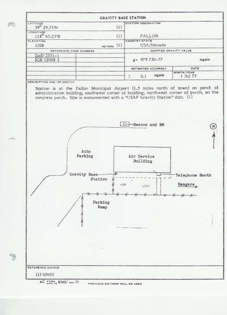
3 INTRODUCTION Gravity data were acquired over the Teels Marsh Prospect in Mineral County, Nevada for Dajin Resources (US) Corp. The gravity survey was conducted between February 24 and March 5, A total of 415 new gravity stations were acquired. Three hundred and seven (307) stations were acquired on a 250m grid and 108 station were regional stations collected on roads and tracks. Field operations were based out of Hawthorne, NV. Relative gravity measurements were made with LaCoste & Romberg Model-G gravity meters. Topographic surveying was performed with Trimble Real-Time Kinematic (RTK) and Fast-Static GPS. Gravity data were processed to Complete Bouguer Gravity and merged with existing USGS public domain gravity data. Maps of the Complete Bouguer Anomaly, First Vertical Derivative, Horizontal Gravity Gradient, and Residual Gravity were prepared and delivered. Additionally, consulting geophysicist Jim Wright used these gravity data to prepare a 3D basin model and produce a map of depth to bedrock. DATA ACQUISITION Survey Personnel Gravity Meters Gravity Base GPS Equipment Data acquisition and surveying were performed by Jack Magee, Tony Kelsoe, and Kevin Foxcroft. Christopher Magee supervised all operations and completed final data processing. Three LaCoste & Romberg Model-G gravity meters, serial numbers G-018, G-392, and G-406, were used on the survey. Model-G gravity meters measure relative gravity changes with a resolution of 0.01 mgal. The manufacturer's calibration tables used to convert gravity meter counter units to milligals are included with the delivered data. The gravity survey is tied to a previously established gravity base designated HOLIDAY located at the Holiday Lodge Motel in Hawthorne, NV. The HOLIDAY base is tied to the existing US Department of Defense (DoD) gravity base at the Fallon Airport (DoD reference number ). Information on the FALLON and HOLIDAY bases is listed below and gravity base descriptions are included in Appendix A. Base Absolute Gravity Latitude Longitude Elevation HOLIDAY m FALLON m All gravity stations were surveyed using the Real-Time Kinematic (RTK) GPS method or, where it was not possible to receive GPS base information via radio modem, the Fast-Static (postprocessing) method was used. The following GPS equipment was used on the project: Trimble Model 5700 Dual-Frequency GPS Receivers and Trimble Model R8 Receivers 1
4 Trimble Model TSCe & TSC2 Data Collector/controllers Trimble TrimMark III base radios and repeaters Trimble Zephyr GPS antennas Trimble Business Center (Version 3.40) was used for GPS data processing. Geodetic Survey Control A single GPS base station, designated TM, was used on this project. The coordinates and elevation of this base station location were determined by making simultaneous GPS occupations in the Fast Static mode with Continuously Operating Reference Stations (CORS). GPS data for this station were submitted to the National Geodetic Survey (NGS) OPUS service which is an automated system that uses the three closest CORS stations to determine coordinates and elevations for unknown stations. The OPUS results are included in Appendix B. The coordinates and elevation of station TM are listed below. Station WGS-84 Latitude WGS-84 Longitude WGS-84 Ellipsoid Ht. TM N " W ' m WGS84 UTM Northing WGS84 UTM Easting Elevation (NAVD29) m m m Topographic Surveying of Gravity Stations Gravity Stations All topographic surveying was performed simultaneously with gravity data acquisition. The gravity stations were surveyed in WGS84 UTM Zone 11 North coordinates in meters. The GEOID12A geoid model was used to calculate NAVD88 elevations from ellipsoid heights. The elevations were then converted to North American Vertical Datum of 1929 (NAVD29) using the NGS program VERTCON. The coordinate system parameters used on this survey are summarized below. Datum Datum Name WGS84 Ellipsoid GRS80 Semi-Major Axis m Eccentricity Transformation None Projection Type Universal Transverse Mercator Zone UTM 11 North Origin Latitude 00º 00' " N Central Meridian 117º 00' " W Scale Factor False Northing 0 False Easting m Geoid Model GEOID12A (CONUS) A total of 415 new gravity stations were acquired and merged with 95 USGS public domain stations. Stations were reached by ATV or on foot. A station location is shown on the following page. 2

5 Teels Marsh Gravity Survey Station Location Map DATA PROCESSING Overview Field data including station identifier, local time, gravity reading, measured slope, and operator remarks were recorded in field notebooks and on GPS survey controllers at each station. The recorded data were then uploaded onto a laptop computer and formatted into GeoSoft RAW gravity files. All survey coordinates were transferred digitally. 3
6 All gravity data processing was performed with the Gravity and Terrain Correction module of Geosoft Oasis Montaj (Version 8.3). Gravity data were processed to Complete Bouguer Gravity over a range of densities from 2.00 g/cc through 3.00 g/cc at steps of 0.05 g/cc using standard procedures and formulas. Color contoured images of the Complete Bouguer Anomaly, First Vertical Derivative, Horizontal Gravity Gradient, and Residual Gravity are included in Appendix D. The Residual Gravity was prepared by upward continuing the Complete Bouguer Anomaly 500 meters then subtracting the upward continued gravity from Complete Bouguer. A grid cell size of 100 meters was used in the preparation of all of the grids and maps. Data Processing Parameters Terrain Corrections The following parameters were used to reduce the gravity data: GMT Offset Gravity Formula Gravity Datum -8 hours 1967 ISGN-71 Terrain Corrections were calculated to a distance of 167 km for each gravity station. The terrain correction for the distance of 0 to 10 meters around each station was calculated using a sloped triangle method with the average slopes measured in the field. The terrain correction for the distance of 10 meters to 2000 meters around each station was calculated using a combination of a prism method and a sectional ring method with digital terrain from 10-meter Digital Elevation Models (DEM). The terrain correction for the distance of 2 to 167 kilometers around each station was calculated using the sectional ring method and digital terrain from SRTM/90-meter DEMs. Gravity Repeats and Loop Closures Gravity repeat statistics for the Teels Marsh gravity surveys follow: Total number of stations: 415 Number of repeated stations: 32 % stations repeated : 7.7% Total number of readings: 471 Number of repeat readings: 56 % readings repeated: 11.9% Maximum repeat error: mgal Mean repeat error: mgal RMS error: mgal A listing of all the gravity loops and their respective closure errors is included in Appendix C. The mean of the absolute value of all loop closure errors is mgal. 4
7 DATA FILES Raw Data Files The raw data files are named with the gravity meter serial number, date, and operators initials. The format is gnnn_mmm_dd_2015_iii.txt where gnnn is the serial number of the gravity meter, mmm is the month, dd is the date on which the gravity loop was acquired, and iii are the operator s initials. The raw data file and GeoSoft database file (.gdb) for each day s data are included with the delivered data. Final Gravity XYZ File The final Geosoft DataBase (GDB) file with all principle facts for the Teels Marsh Gravity Survey is named Teels_Marsh_Gravity_Merge_06MAR2015.gdb with a corresponding XYZ file named Teels_Marsh_Gravity_Merge_06MAR2015.csv. The data columns in the file include headers identifying the value of each column. GeoSoft Database Files All of the additional GeoSoft database (.gdb) files associated with the data processing are also included with the delivered data, these are: Grid and Terrain Files Final coordinate and elevation listing Coords_thru_Mar05_NAVD29.gdb Master gravity database Teels_Marsh_Gravity_Merge_06MAR2015.gdb Gravity Base Station database TeelsMarsh_GravBase.gdb The file names for the grid files used to create the images in this report and to calculate the terrain corrections are as follows and are included with the delivered data. Local terrain file Teels_10m_DEM_WGS84UTM11.grd Regional terrain file Nevada_90m_DEM_final_WGS84UTM11.grd Regional terrain correction output file Teels_167km_tc.grd Complete Bouguer Anomaly Geosoft Grid File cbg240merge.grd First Vertical Derivative Geosoft Grid File cbg240merge_1 st _Vert_Derivative.grd Horizontal Gravity Gradient Geosoft Grid File cbg240merge_horiz_gradient.grd 500m Upward Continued Gravity (Regional) Geosoft Grid File cbg240merge_uc_500m_regional.grd 5
8 GPS Data Files 500m Upward Continued Gravity Removed (Residual) Geosoft Grid File cbg240merge_uc 500m_Residual.grd Each Geosoft grid file also corresponds to a PDF map file and an exported/registered GEOTIFF file that are included with delivered data. The raw and processed GPS data are included with the delivered data as Trimble Business Center and/or Trimble Geomatics Office projects and are organized in folders by date. Submitted by: Christopher Magee Geophysicist Magee Geophysical Services LLC 6

9 APPENDIX A GRAVITY BASE DESCRIPTIONS
10
11 APPENDIX B GEODETIC CONTROL FILE: o OP Station: TM NGS OPUS SOLUTION REPORT ======================== All computed coordinate accuracies are listed as peak-to-peak values. For additional information: USER: caitlin_bernier@gravityandmag.com DATE: February 28, 2015 RINEX FILE: q.15o TIME: 22:25:56 UTC SOFTWARE: page master53.pl START: 2015/02/26 16:37:00 EPHEMERIS: igr18334.eph [rapid] STOP: 2015/02/27 00:20:30 NAV FILE: brdc n OBS USED: / : 98% ANT NAME: TRM NONE # FIXED AMB: 86 / 91 : 95% ARP HEIGHT: OVERALL RMS: 0.012(m) REF FRAME: NAD_83(2011) (EPOCH: ) IGS08 (EPOCH: ) X: (m) 0.017(m) (m) 0.017(m) Y: (m) 0.013(m) (m) 0.013(m) Z: (m) 0.011(m) (m) 0.011(m) LAT: (m) (m) E LON: (m) (m) W LON: (m) (m) EL HGT: (m) 0.021(m) (m) 0.021(m) ORTHO HGT: (m) 0.037(m) [NAVD88 (Computed using GEOID12A)] UTM COORDINATES STATE PLANE COORDINATES UTM (Zone 11) SPC (2703 NV W) Northing (Y) [meters] Easting (X) [meters] Convergence [degrees] Point Scale Combined Factor US NATIONAL GRID DESIGNATOR: 11SLC (NAD 83) BASE STATIONS USED PID DESIGNATION LATITUDE LONGITUDE DISTANCE(m) DM7575 P636 LOGCABINRFCS2007 CORS ARP N W AH2502 MINS MINARET SUMMIT CORS ARP N W DN7458 P651 CHALFANTVACS2006 CORS ARP N W NEAREST NGS PUBLISHED CONTROL POINT AH8154 BM 28 RBR N W This position and the above vector components were computed without any knowledge by the National Geodetic Survey regarding the equipment or field operating procedures used.
12 APPENDIX C GRAVITY LOOP CLOSURES Loop File Loop Closure G018_Feb_24_2015_KRF G392_Feb_24_2015_AJK G406_Feb_24_2015_JCM G018_Feb_25_2015_KRF G406_Feb_25_2015_JCM G018_Feb_26_2015_KRF G406_Feb_26_2015_JCM G392_Feb_27_2015_AJK G406_Feb_27_2015_JCM G018_Feb_28_2015_KRF G392_Feb_28_2015_AJK G406_Feb_28_2015_JCM G018_Mar_01_2015_KRF G392_Mar_01_2015_AJK G406_Mar_01_2015_JCM G018_Mar_02_2015_KRF G392_Mar_02_2015_AJK G406_Mar_02_2015_JCM G018_Mar_03_2015_KRF G392_Mar_03_2015_AJK G406_Mar_03_2015_JCM G018_Mar_04_2015_KRF G392_Mar_04_2015_AJK G406_Mar_04_2015_JCM G018_Mar_05_2015_KRF G392_Mar_05_2015_AJK G406_Mar_05_2015_JCM Average Loop Closure Absolute Value 0.029
13 APPENDIX D GRAVITY MAPS Teels Marsh Gravity Survey Complete Bouguer Density 2.40 g/cc Contour Interval 0.2 mgal
14 Teels Marsh Gravity Survey First Vertical Derivative Contour Interval mgal/m
15 Teels Marsh Gravity Survey Horizontal Gravity Gradient Contour Interval mgal/m
16 Teels Marsh Gravity Survey Residual Gravity Contour Interval 0.2 mgal
KEYSTONE PROPERTY GRAVITY GIS DATABASE. Residual Gravity Looking Down to Northwest
 KEYSTONE PROPERTY GRAVITY - 2018 GIS DATABASE Residual Gravity Looking Down to Northwest James L. Wright M.Sc. May 11, 2018 TABLE OF CONTENTS INTRODUCTION......................... 2 SURVEY PROCEDURE......................
Using UNAVCO Real-Time CORS Data, a No-Cost Positioning Resource
 Using UNAVCO Real-Time CORS Data, a No-Cost Positioning Resource By: Mark Silver, ms@igage.com, +1-801-412-0011 Date: 19 August 2014 UNAVCO is a non-profit consortium of Universities that coordinates the
COPPER KING PROPERTY GROUND MAGNETIC SURVEY GIS DATABASE. Ground Magnetic Survey Preliminary Interpretation
 COPPER KING PROPERTY GROUND MAGNETIC SURVEY GIS DATABASE Ground Magnetic Survey Preliminary Interpretation James L. Wright M.Sc. July 18, 2017 TABLE OF CONTENTS INTRODUCTION......................... 2
HORIZONTAL PROJECTION PARAMETERS: DANE COUNTY COORDINATES
 Recommended RTK GPS Configuration Parameters for the City of Madison, WI Base Station Compiled by: Dan Rodman RLS, City of Madison (608)266-6674 drodman@cityofmadison.com For base station information see
Town of Chino Valley. Survey Control Network Report. mgfneerhg mc N. Willow Creek Road Prescott AZ
 Town of Chino Valley Survey Control Network Report mgfneerhg mc. 2050 N. Willow Creek Road Prescott AZ 86301 928-771-2376 Page 1 of 70 Table of Contents Town of Chino Valley Survey Datum Outline A short
Control Surveys and Coordinate Systems
 Control Surveys and Coordinate Systems The Earth is Round Basic Shape of the Earth: Oblate Spheroid of Revolution The length of the equatorial axis is approximately 27 miles greater than the polar axis.
Bathymetric and Sediment Survey of Pottawatomie Lake #1, Pottawatomie County, Kansas
 Bathymetric and Sediment Survey of Pottawatomie Lake #1, Pottawatomie County, Kansas Kansas Biological Survey Applied Science and Technology for Reservoir Assessment (ASTRA) Program Report 2010-10 (October
Bathymetric and Sediment Survey of Alma City Lake, Wabaunsee County, Kansas
 Bathymetric and Sediment Survey of Alma City Lake, Wabaunsee County, Kansas Kansas Biological Survey Applied Science and Technology for Reservoir Assessment (ASTRA) Program Report 2011-13 (March 2011)
Meeting the ODOT Survey & Mapping Specifications
 Meeting the ODOT Survey & Mapping Specifications A Simple Solution Presented by Ray Foos, P.S, ODOT CADD & Mapping Services & Jon Keller, P.S., ODOT District 3 Phases of an ODOT Survey Project Research
GEODESY LESSON PLAN All Shook Up
 All Shook Up Lesson Plan GEODESY LESSON PLAN All Shook Up Focus Displacement of the Earth s crust due to seismic events Grade Level 9-12 Focus Question How can we measure movements in the Earth s crust
Achieving Great Height with GNSS
 Achieving Great Height with GNSS Oregon GPS Users Group 2015 Annual Meeting January 23, 2015 Salem, Oregon Salem Convention Center Michael Dennis, RLS, PE Oregon State University National Geodetic Survey
An Assessment of the Accuracy of PPP in Remote Areas in Oman
 An Assessment of the Accuracy of PPP in Remote Areas in Oman Rashid AL ALAWI, Sultanate of Oman and Audrey MARTIN, Ireland Keywords: GNSS, PPP, Oman Survey Infrastructure SUMMARY Traditionally, high accuracy
Analytical and Computer Cartography Lecture 3: Review: Coordinate Systems
 Analytical and Computer Cartography Lecture 3: Review: Coordinate Systems Geographic Coordinates NAD83 NAD27 remained in use until the earthcentered international GRS80 was complete (Geodetic Reference
The National Spatial Reference System of the Future
 The National Spatial Reference System of the Future William Stone Southwest Region (AZ, NM, NV, UT) Geodetic Advisor william.stone@noaa.gov NOAA s National Geodetic Survey geodesy.noaa.gov Salt Lake City
ch02.pdf chap2.pdf chap02.pdf
 Introduction to Geographic Information Systems 8th Edition Karl Solutions Manual Full Download: http://testbanklive.com/download/introduction-to-geographic-information-systems-8th-edition-karl-solutions-manu
NGS and the Modernization of the National Spatial Reference System (NSRS)
") NGS and the Modernization of the National Spatial Reference System (NSRS) Dr. Dana Caccamise Pacific Southwest Region (CA,NV) Geodetic Advisor dana.caccamise@noaa.gov NOAA s National Geodetic Survey geodesy.noaa.gov
NGS and the Modernization of the National Spatial Reference System (NSRS) Dr. Dana Caccamise Pacific Southwest Region (CA,NV) Geodetic Advisor dana.caccamise@noaa.gov NOAA s National Geodetic Survey geodesy.noaa.gov
BUILDING AN ACCURATE GIS
 BUILDING AN ACCURATE GIS 2006 GIS in the Rockies Denver, Colorado September 13, 2006 William E. Linzey United States Department of Commerce National Oceanic and Atmospheric Administration National Geodetic
Approaches to GNSS & Geodesy
 Approaches to GNSS & Geodesy Ray Hintz Univ. of Maine Ray.hintz@.maine.edu The biggest complaint about state plane coordinates The concept that scale and elevation factor need to be applied to the pythagoreum
GISC3325 Spring 2011 Final Exam
 GISC3325 Spring 2011 Final Exam Name: Carefully read each question. Identify the important elements and the question being asked. Show your work for partial credit. No credit for undocumented wrong answers.
HIMALAYAN AIRBORNE GRAVITY AND GEOID OF NEPAL
 Mt. Everest HIMALAYAN AIRBORNE GRAVITY AND GEOID OF NEPAL -Niraj Manandhar Head, Geodetic Survey Branch Survey Department, Geodetic Survey Branch Project Background Air Borne Gravity Survey Project was
Lesson 5: Map Scale and Projections
 Organizing Data and Information Lesson 5: Map Scale and Projections Map Scales Projections Information can be organized as lists, numbers, tables, text, pictures, maps, or indexes. Clusters of information
How does an ellipsoid differ from a sphere in approximating the shape and size of the Earth?
 Chapter 02 Test Bank Worksheet Questions 1. What is a map projection? Topic: Map Projection 2. How does an ellipsoid differ from a sphere in approximating the shape and size of the Earth? Topic: Ellipsoid
What is a Map Projection?
 What is a Map Projection? It is how we represent a three dimensional Earth on a flat piece of paper However The process of transferring information from the Earth to a map causes every projection to distort
ELECTRONICS DIVISION INTERNAL REPORT NO. 324
 NATIONAL RADIO ASTRONOMY OBSERVATORY Green Bank, West Virginia ELECTRONICS DIVISION INTERNAL REPORT NO. 324 NRAO 43m Antenna Coordinates and Angular Limits (Version 4) Glen Langston September 14, 2012
Spatial Data Collection using GPS: BEST PRACTICES
 Spatial Data Collection using GPS: BEST PRACTICES - 2007 Page 1 of 10 Best practices for GPS & Spatial Data Collection, Storage and Documentation These Best Practices are designed to maximize positional
Introduction to Geographic Information Science. Updates/News. Last Lecture. Geography 4103 / Map Projections and Coordinate Systems
 Geography 4103 / 5103 Introduction to Geographic Information Science Map Projections and Coordinate Systems Updates/News Thursday s lecture Reading discussion 1 find the readings online open questions,
VT State Plane. Daniel J. Martin National Geodetic Survey VT Geodetic Advisor. VSLS Conference Rutland VT April 11, 2008
 VT State Plane Daniel J. Martin National Geodetic Survey VT Geodetic Advisor VSLS Conference Rutland VT April 11, 2008 Today s Outline Define the problem Review of VT State Plane System Relationship
This week s topics. Week 6. FE 257. GIS and Forest Engineering Applications. Week 6
 FE 257. GIS and Forest Engineering Applications Week 6 Week 6 Last week Chapter 8 Combining and splitting landscape features and merging GIS databases Chapter 11 Overlay processes Questions? Next week
Intro to GIS Fall 2010 Georeferencing & Map Projections
 Intro to GIS Fall 2010 Georeferencing & Map Projections SHAPE OF THE EARTH Earth's Shape Geoid: shape of earth minus topographic features (irregular due to local variations in gravity) Ellipsoid: elongated
GRAVITY AND MAGNETIC SURVEY NECHAKO BASIN STUDY ACQUISITION AND PROCESSING PHASE
 GRAVITY AND MAGNETIC SURVEY NECHAKO BASIN STUDY ACQUISITION AND PROCESSING PHASE Report prepared for the B.C. Ministry of Energy and Mines Resource Development Division New Ventures Branch by Bemex Consulting
Precise Hong Kong Geoid HKGEOID-2000
 Yong-Qi Chen 1, Zhicai Luo 1 and Simon Kwok 2 1.Department of Land Surveying and Geo-Informatics, The Hong Kong olytechnic University 2 Geodetic Survey Section, Lands Department, HKSAR Abstract: This paper
CE 316 GEOMATICS COURSE NOTES DR. MOIR D HAUG, C.L.S., P. ENG. JANUARY 2012
 CE 316 GEOMATICS COURSE NOTES DR. MOIR D HAUG, C.L.S., P. ENG. JANUARY 2012 0 COURSE INFORMATION Dr Moir D Haug, P. Eng University Office 2B25 Engineering 966 5355 moir.haug@usask.ca MDH Engineered Solutions
Ground Truth Annual Conference. Design and Documentation of Low Distortion Projections for Surveying and GIS
 Professional Land Surveyors of Oregon 15 Annual Conference Ground Truth Design and Documentation of Low Distortion Projections for Surveying and GIS Michael L Dennis, RLS, PE v. (rev 1), January 15, Design
Technical Support: Data Submission
 Why do we want your data? How should I observe data for submission? The objective behind data submissions is to leverage ongoing field work to provide industry with an up-todate network of NAD83 (CSRS)
Geographic Information Systems class # 1 February 19, Coordinate reference systems in GIS: geodetic coordinates
 Geographic Information Systems class # 1 February 19, 2013 Coordinate reference systems in GIS: geodetic coordinates Manuel Campagnolo ISA Manuel Campagnolo (ISA) GIS/SIG 2012 2013 February 19, 2013 1
NATRF 2022 AND LDP OCTOBER 11, 2017
 NATRF 2022 AND LDP OCTOBER 11, 2017 MODERNIZATION OF THE NSRS Why? Leaving passive control marks behind and relying solely on the CORS network for 3D positions: Older methodology relies on terrestrial
12/26/2012. Geographic Information Systems * * * * GIS (... yrezaei
 ( - Geographic Information Systems ( ( 1 2 3 Information System Data base DB IS IS DB (Knowledge ( ( (System (Information System - (Georefrence Analysis Data + Knowledge ======== Information 4 5 ( < 10%
GEOPHYSICAL DATA SET (GDS) 1084B METADATA
 1084B METADATA") GEOPHYSICAL DATA SET (GDS) 1084B METADATA GENERAL INFORMATION Official Name of the Data Set or Information Holding: Ontario Airborne Geophysical Surveys, Magnetic Gradiometer and Gamma-Ray Spectrometric
GEOPHYSICAL DATA SET (GDS) 1084B METADATA GENERAL INFORMATION Official Name of the Data Set or Information Holding: Ontario Airborne Geophysical Surveys, Magnetic Gradiometer and Gamma-Ray Spectrometric
Low Distortion Projections Part 2 Ground versus Grid
 Blue Marble Geographic Calculator provides an incredible variety of tools for working with an infinite combination of datums and projections. Shown here, I ve entered the parameters for a Low Distortion
Client RSK Environment Ltd Job No. J387 Date 19/11/2016. Project: Environmental Survey Location: Otranto Vessel: RV Atlante
 FUGRO OCEANSISMICA S.p.A. GEODETIC PARAMETERS Client RSK Environment Ltd Job No. J387 Date 19/11/216 Project: Environmental Survey Location: Otranto Vessel: RV Atlante WGS-84 Geodetic Parameters Datum
Ground Truth Annual Conference. Optimized Design of Low Distortion Projections. Michael L. Dennis, RLS, PE
 Arizona Professional Land Surveyors Association 016 Annual Conference Ground Truth Optimized Design of Low Distortion Projections Michael L. Dennis, RLS, PE Version 3 (rev 1), May 016 Design and metadata
TOWARDS ROBUST LOCALIZATION OF RTK-GPS TOPOGRAPHIC SURVEYS 23
 TOWARDS ROBUST LOCALIZATION OF RTK-GPS TOPOGRAPHIC SURVEYS Jerry W. Nave, North Carolina A&T University; Tarig A. Ali, American University of Sharjah Abstract Localization is performed to fit the observed
MODERNIZATION OF THE NSRS
 NATRF 2022 AND LDP SEPTEMBER 12, 2017 MODERNIZATION OF THE NSRS Why? Leaving passive control marks behind and relying solely on the CORS network for 3D positions: Older methodology relies on terrestrial
Georeferencing, Map Projections, Cartographic Concepts. -Coordinate Systems -Datum
 Georeferencing, Map Projections, Cartographic Concepts -Map Projections -Coordinate Systems -Datum Map projection is "the process of systematically transforming positions on the Earth's spherical surface
When the Earth Was Flat. Measurements were made using a plumb bob, a spirit level, and a stick. Also, the Stars.
 ABSTRACT Defining the shape of the Earth geoid. Mathematical models spheroid or ellipsoid Mathematical projection of geodetic systems GIS/GPS technology The need for a unified projection systems World
WHERE ARE YOU? Maps & Geospatial Concepts Fall 2012
 WHERE ARE YOU? Maps & Geospatial Concepts Fall 2012 Where are you? Relative location I m at school Absolute Location 45 26 18.07 122 43 50.78 Datums Datums A reference surface of the Earth Used as the
This Land Surveying course has been developed by Failure & Damage Analysis, Inc.
 This Land Surveying course has been developed by Failure & Damage Analysis, Inc. www.discountpdh.com DEPARTMENT OF THE ARMY U.S. Army Corps of Engineers CECW-EP Washington, DC 20314-1000 ETL 1110-1-183
Lecture 4. Coordinate Systems & Projections
 Lecture 4 Coordinate Systems & Projections Outline Geodesy Geoids Ellipsoids Geographic Coordinate Systems Magnetic North vs. True North Datums Projections Applying Coordinate Systems and Projections Why
NR402 GIS Applications in Natural Resources Lesson 4 Map Projections
 NR402 GIS Applications in Natural Resources Lesson 4 Map Projections From http://www.or.blm.gov/gis/ 1 Geographic coordinates Coordinates are expressed as Latitude and Longitude in Degrees, Minutes, Seconds
SURVEYING AND MAPPING, INC. COORDINATE DATA SHEET JOB: CITY OF DECATUR CLIENT: CITY OF DECATUR SAM JOB#:
 13 March 2001 SURVEYING AND MAPPING, INC. COORDINATE DATA SHEET JOB: CITY OF DECATUR CLIENT: CITY OF DECATUR SAM JOB#: 21038-20 HORIZONTAL DATUM: NAD-83 GEODETIC VERTICAL STATION ID LATITUDE LONGITUDE
GPS Remote Sensing. GIS Photogrammetry. GEODESY Equipment (total station) CARTOGRAPHY Survey Software. Map Projection Coordinate Systems
 CARTOGRAPHY Survey Software. Map Projection Coordinate Systems") GPS Remote Sensing GIS Photogrammetry GEODESY Equipment (total station) CARTOGRAPHY Survey Software Map Projection Coordinate Systems 1 Coordinate Systems, Datum and Map Projection Dr. Maher A. El-Hallaq
GPS Remote Sensing GIS Photogrammetry GEODESY Equipment (total station) CARTOGRAPHY Survey Software Map Projection Coordinate Systems 1 Coordinate Systems, Datum and Map Projection Dr. Maher A. El-Hallaq
Week 02. Assist. Prof. Dr. Himmet KARAMAN
 Week 02 Assist. Prof. Dr. Himmet KARAMAN Contents Satellite Orbits Ephemerides GPS Review Accuracy & Usage Limitation Reference Systems GPS Services GPS Segments Satellite Positioning 2 Satellite Orbits
Fusion of Geodesy and GIS at NOAA s National Geodetic Survey
 Fusion of Geodesy and GIS at NOAA s National Geodetic Survey Esri Survey Summit July 6-9, 2013 San Diego, CA Michael Dennis, RLS, PE michael.dennis@noaa.gov The Plan Background NGS Data Explorer New Datasheet
THE DEAD SEA RIFT VALLEY
 JOINT ISRAELI-PALESTINIAN GRAVITY SURVEY IN THE DEAD SEA RIFT VALLEY by M. Rybakov The Geophysical Institute of Israel P.O. Box 182 Lod, 7 1 100 Israel R El-Kelani Earth Sciences and seismic engineering
A Detailed Examination of DTM Creation Methods and Sources. Study Area Overview
 A Detailed Examination of DTM Creation Methods and Sources Adam Mosbrucker & Melinda Lamb Geography 593: Dec. 2 nd, 2010 Study Area Overview Mt. St. Helens -active volcano many eruptions in the past 30
4 Survey Datums. 4.1 Horizontal Datum Policy SURVEY DATUMS SEPTEMBER 2006
 4 Survey Datums Today s multi-organizational Project Development efforts require the use of common, accurate horizontal and vertical survey datums and consistent, precise control-survey procedures to ensure
Determination of Subsurface Bulk Density Distribution for Geotechnical Investigation using Gravity Technique
 Journal of Earth Sciences and Geotechnical Engineering, vol. 7, no.2, 2017, 63-69 ISSN: 1792-9040 (print), 1792-9660 (online) Scienpress Ltd, 2017 Determination of Subsurface Bulk Density Distribution
Butte County Fire Department
 Butte County Fire Department Basic Land Navigation Verification Sheet I verify that Print Supervisor s name has completed the Print Employee s name Basic Land Navigation self study guide on. Date Attached
[RAPPORT MEETING BROKOPONDO]
![[RAPPORT MEETING BROKOPONDO]](/thumbs/93/112235393.jpg "[RAPPORT MEETING BROKOPONDO]") [RAPPORT MEETING BROKOPONDO] April 28, 2016 INLEIDING: Op woensdag 9 december 2015 is er een Leica antenne geïnstalleerd op het dak van het gebouw waar de District Commissaris van Brokopondo gehuisvest
[RAPPORT MEETING BROKOPONDO] April 28, 2016 INLEIDING: Op woensdag 9 december 2015 is er een Leica antenne geïnstalleerd op het dak van het gebouw waar de District Commissaris van Brokopondo gehuisvest
Localization & Grid to Ground Scale Factors in SurvCE
 Localization & Grid to Ground Scale Factors in SurvCE Mark Silver, ms@igage.com, +1-801-412-0011 x16, blog.ashgps.com Grid-to-Ground CSF is function of: Latitude, Elevation and Projection Difficult to
MINFO. October Format and Content. Airborne Geophysical Survey data Submissions. To Exploration and Mining Division
 MINFO Format and Content of Airborne Geophysical Survey data Submissions To Exploration and Mining Division October 2013 Exploration and Mining Division, Department of Communications, Climate Action and
SOURCE: NAVD88 (Computed using GEOID12B)
") Shared Solution https://www.ngs.noaa.gov/opus/getdatasheet.jsp?pid=... 1 of 1 10/2/2018, 2:52 PM Shared Solution PID: Designation: NYKT R1 Stamping: NYKT R1 2005 Stability: May hold commonly subject to
Shared Solution https://www.ngs.noaa.gov/opus/getdatasheet.jsp?pid=... 1 of 1 10/2/2018, 2:52 PM Shared Solution PID: Designation: NYKT R1 Stamping: NYKT R1 2005 Stability: May hold commonly subject to
Lab 1: Importing Data, Rectification, Datums, Projections, and Coordinate Systems
 Lab 1: Importing Data, Rectification, Datums, Projections, and Coordinate Systems Topics covered in this lab: i. Importing spatial data to TAS ii. Rectification iii. Conversion from latitude/longitude
METHODOLOGY & TESTING PROCEDURE
 METHODOLOGY & TESTING PROCEDURE Bartlett & West is committed to using the MidStates VRS system going forward into 2016. We realize that having a state wide VRS will mean a savings of time on our projects
Coordinate Systems and Datum Transformation in ArcGIS. Brittney White and Melita Kennedy
 Coordinate Systems and Datum Transformation in ArcGIS Brittney White and Melita Kennedy Where is my data? Problem Horizontal Vertical Projections Transformations Horizontal coordinate systems Geographic
NGS Data Sheets for Rifle HARN Points
 NGS Data Sheets for Rifle HARN Points DATABASE = Sybase,PROGRAM = datasheet, VERSION = 6.98 1 National Geodetic Survey, Retrieval Date = MARCH 17, 2004 ***********************************************************************
EESC Geodesy with the Global Positioning System. Class 6: Point Positioning using Pseuduorange
 EESC 9945 Geodesy with the Global Positioning System Class 6: Point Positioning using Pseuduorange GPS Positioning Solutions Point Positioning: Determination of the coordinates of a point with respect
Metadata for 2005 Orthophotography Products
 Metadata for 2005 Orthophotography Products What does this data set describe? 1. How should this data set be cited? 2. What geographic area does the data set cover? 3. What does it look like? 4. Does the
GCSAR Navigation -- Maps
 GCSAR Navigation -- Maps From the GCSAR Certification Standards Identify and explain all the border information on a topographic map. Identify and explain the following aspects of maps: index and intermediate
Modernization of the National Spatial Reference System 2022 Datum. Jacksonville Chapter July 2018
 Modernization of the National Spatial Reference System 2022 Datum Jacksonville Chapter July 2018 Randy Tompkins, PSM, PLS Geomatics Project Manager Surveyor, Hydrographer, & Geodesist DRMP, Inc. Jacksonville,
GPS and Mean Sea Level in ESRI ArcPad
 Summary In order to record elevation values as accurately as possible with, it is necessary to understand how ArcPad records elevation. Rather than storing elevation values relative to Mean Sea Level (MSL),
WHERE ARE YOU? Maps & Geospatial Concepts Fall 2015
 WHERE ARE YOU? Maps & Geospatial Concepts Fall 2015 Where are you? Relative location I m at school Absolute Location 45 26 18.07 122 43 50.78 Where is Boston? Introducing Geodesy, Ellipsoids & Geoids Geodesy
CONTROL MONUMENT REPORT
 CONTROL MONUMENT REPORT This document was prepared by Altus Geomatics for use by City of Yorkton staff and contractors working in and for the City of Yorkton. This document is meant to inform readers about
Geospatial Data Standards Considerations for the delivery of 2D and 3D spatial data February 2019
 Geospatial Data Standards Considerations for the delivery of 2D and 3D spatial data February 2019 Prepared by: GRCA Geomatics Version Date Summary of Changes Changes Made By: 1.00 March 16, 2018 Version
Projections and Coordinate Systems
 Projections and Coordinate Systems Overview Projections Examples of different projections Coordinate systems Datums Projections Overview Projections and Coordinate Systems GIS must accurately represent
Gravity reduction spreadsheet to calculate the Bouguer anomaly using standardized methods and constants
 Gravity reduction spreadsheet to calculate the Bouguer anomaly using standardized methods and constants Derek I. Holom John S. Oldow Department of Geological Sciences, University of Idaho, Moscow, Idaho
Frames for the Future New Datum Definitions for Modernization of the U.S. National Spatial Reference System
 Figure 10. Horizontal position differences (in meters) between NAD 83 and ITRF 08 at time 2022.00 (January 1, 2022). Positional differences are shown for the North American and Pacific tectonic plates.
April 24, :00 to 5:00 p.m.
 Datums, Coordinate Systems, Low Distortion Projections (LDP), & the Global Spatial Data Model (GSDM) Hosted by: City of Las Cruces Public Works/Project Development and Community Development/GIS April 24,
start of Swedish national maps.
 1809 - start of Swedish national maps. Corps of military field measurement Triangulation network Spheroid: Bessel 1841 Semimajor axis: : 6377397.155 Semiminor axis: : 6356078.963 Inverse flattening: :
Digital Elevation Models (DEM)
") Digital Elevation Models (DEM) Digital representation of the terrain surface enable 2.5 / 3D views Rule #1: they are models, not reality Rule #2: they always include some errors (subject to scale and data
Digital Elevation Models (DEM) Digital representation of the terrain surface enable 2.5 / 3D views Rule #1: they are models, not reality Rule #2: they always include some errors (subject to scale and data
Map Projections. Displaying the earth on 2 dimensional maps
 Map Projections Displaying the earth on 2 dimensional maps Map projections Define the spatial relationship between locations on earth and their relative locations on a flat map Are mathematical expressions
Overview key concepts and terms (based on the textbook Chang 2006 and the practical manual)
") Introduction Geo-information Science (GRS-10306) Overview key concepts and terms (based on the textbook 2006 and the practical manual) Introduction Chapter 1 Geographic information system (GIS) Geographically
Introduction Geo-information Science (GRS-10306) Overview key concepts and terms (based on the textbook 2006 and the practical manual) Introduction Chapter 1 Geographic information system (GIS) Geographically
Dr. ABOLGHASEM AKBARI Faculty of Civil Engineering & Earth Resources, University Malaysia Pahang (UMP)
") Workshop on : Dr. ABOLGHASEM AKBARI Faculty of Civil Engineering & Earth Resources, University Malaysia Pahang (UMP) 14-15 April 2016 Venue: Tehran, Iran GIS definitions GIS: A simplified view of the real
Workshop on : Dr. ABOLGHASEM AKBARI Faculty of Civil Engineering & Earth Resources, University Malaysia Pahang (UMP) 14-15 April 2016 Venue: Tehran, Iran GIS definitions GIS: A simplified view of the real
Publication 15_H055. Absolute and Relative Gravity Survey University of Hawai i-manoa and Pier 35 Honolulu, Hawai i. February - March 2015
 GEODETIC SURVEYS DIVISION UNCLASSIFIED 314 Publication 15_H055 Absolute and Relative Gravity Survey University of Hawai i-manoa and Pier 35 Honolulu, Hawai i February - March 2015 UNCLASSIFIED 2. NATIONAL
Lecture 10-14: Map Projections and Coordinate System
 URP 1281 Surveying and Cartography Lecture 10-14: Map Projections and Coordinate System December 27, 2015 Course Teacher: Md. Esraz-Ul-Zannat Assistant Professor Department of Urban and Regional Planning
MSGIC Spring Mtg Denton April 23, 2014
 Modernization of the National Spatial Reference System Keeping Pace with Changes in Positioning Technology and User Expectations in a Dynamic World MSGIC Spring Mtg Denton April 23, 2014 Dave Doyle Base
Lab 1: Importing Data, Rectification, Datums, Projections, and Output (Mapping)
") Lab 1: Importing Data, Rectification, Datums, Projections, and Output (Mapping) Topics covered in this lab: i. Importing spatial data to TAS ii. Rectification iii. Conversion from latitude/longitude to
Lab 1: Importing Data, Rectification, Datums, Projections, and Output (Mapping) Topics covered in this lab: i. Importing spatial data to TAS ii. Rectification iii. Conversion from latitude/longitude to
Height systems. Rudi Gens Alaska Satellite Facility
 Rudi Gens Alaska Satellite Facility Outline Why bother about height systems? Relevant terms Coordinate systems Reference surfaces Geopotential number 2 Why bother about height systems? give a meaning to
Georeferencing. Place names Postal addresses Postal codes Coordinate systems (lat/long, UTM, etc.)
") Georeferencing Georeferencing Used to describe the act of assigning locations to data or information Certain requirements include that they are: unique, have shared meaning, and are persistent through
Georeferencing Georeferencing Used to describe the act of assigning locations to data or information Certain requirements include that they are: unique, have shared meaning, and are persistent through
Fundamentals of Surveying (LE/ESSE ) Lecture 10
 Lecture 10") Fundamentals of Surveying (LE/ESSE 2620 3.0) Lecture 10 Topographic Mapping Dr.-Ing. Jianguo Wang Geomatics Engineering York University Fall 2017 1 10-1 Introduction Two main types of maps: Line maps Orthophotographic
Fundamentals of Surveying (LE/ESSE 2620 3.0) Lecture 10 Topographic Mapping Dr.-Ing. Jianguo Wang Geomatics Engineering York University Fall 2017 1 10-1 Introduction Two main types of maps: Line maps Orthophotographic
METADATA. Publication Date: Fiscal Year Cooperative Purchase Program Geospatial Data Presentation Form: Map Publication Information:
 METADATA CONTOURS Digital Geospatial Metadata: North Central Texas Orthophotography Identification Information Citation Originator: Publication Date: Fiscal Year 2001-2002 Title: Cooperative Purchase Program
Understanding Projections for GIS
 Presented by John Schaeffer Juniper GIS Services, Inc. This PowerPoint is available at JuniperGIS.com Presentation Objectives To understand basic concepts on projections and coordinate systems for the
King County Explorer Search and Rescue. Course B Map & Compass
 King County Explorer Search and Rescue Course B Map & Compass Disclaimer The intent of this presentation is to provide a basic overview of maps, compasses, and location finding. It is not meant to be a
The Elements of GIS. Organizing Data and Information. The GIS Database. MAP and ATRIBUTE INFORMATION
 GIS s Roots in Cartography Getting Started With GIS Chapter 2 Dursun Z. Seker MAP and ATRIBUTE INFORMATION Data (numbers and text) store as files refer to them collectively as a database gather inform.
Positioning the Pacific: NOAA s Geospatial Activities. Juliana Blackwell, Director NOAA s National Geodetic Survey March 6, 2012
 Positioning the Pacific: NOAA s Geospatial Activities Juliana Blackwell, Director NOAA s National Geodetic Survey March 6, 2012 A Common Problem of the Early 19 th Century 1807 President Thomas Jefferson
The Future of SPCS in Charles Chuck Ghilani, Ph.D. Professor Emeritus Pennsylvania State University
 The Future of SPCS in 2022 Charles Chuck Ghilani, Ph.D. Professor Emeritus Pennsylvania State University Class Etiquette Turn off all cell phones Or set them to vibrate Go out of the room to answer any
Positional Accuracy of the Google Earth Imagery In The Gaza Strip
 Positional Accuracy of the Google Earth Imagery In The Gaza Strip Maher A. El-Hallaq Associate Professor of Surveying Civil Engineering Department The Islamic University of Gaza, Palestine mhallaq@iugaza.edu.ps
1/28/16. EGM101 Skills Toolbox. Oblate spheroid. The shape of the earth Co-ordinate systems Map projections. Geoid
 EGM101 Skills Toolbox Oblate spheroid The shape of the earth Co-ordinate systems Map projections The geoid is the shape that the surface of the oceans would take under the influence of Earth's gravitation
EnvSci360 Computer and Analytical Cartography
 EnvSci360 Computer and Analytical Cartography Lecture 3 Geodesy Map Projections, Datums, and Coordinate Systems 1 Geodesy The science of measuring and representing the shape and size of the earth, and
Generation and analysis of Digital Elevation Model (DEM) using Worldview-2 stereo-pair images of Gurgaon district: A geospatial approach
 using Worldview-2 stereo-pair images of Gurgaon district: A geospatial approach") 186 Generation and analysis of Digital Elevation Model (DEM) using Worldview-2 stereo-pair images of Gurgaon district: A geospatial approach Arsad Khan 1, Sultan Singh 2 and Kaptan Singh 2 1 Department
186 Generation and analysis of Digital Elevation Model (DEM) using Worldview-2 stereo-pair images of Gurgaon district: A geospatial approach Arsad Khan 1, Sultan Singh 2 and Kaptan Singh 2 1 Department