The Future of SPCS in Charles Chuck Ghilani, Ph.D. Professor Emeritus Pennsylvania State University
|
|
|
- Vanessa Stevenson
- 5 years ago
- Views:
Transcription
1 The Future of SPCS in 2022 Charles Chuck Ghilani, Ph.D. Professor Emeritus Pennsylvania State University
2 Class Etiquette Turn off all cell phones Or set them to vibrate Go out of the room to answer any calls You can ask questions at any point during the class. Simply speak up so that all can hear your question If you can t hear, ask me to repeat the question.
3 What You Will Learn The reason for changing NAD83 NGS s plans for future changes in datums and SPCS Options NGS is providing to states Dual and/or single zones Zones designed at heights to reduce/no remove distortion to distances Differences in current systems and proposed system for 2022 Single parallel versus two standard parallels
4 Discussion Topics Future plans by NGS for SPCS in PA Needs agreement of any change from constituents PennDOT PSLS PSPE Geospatial consortium (GIS community) Others?
5 Surfaces of the Earth Topographic (4 in picture) Geoid (aka Spheroid) (5 in picture) Equipotential (based on gravity) surface (H) Geoid model (Geoid 12B) Ellipsoid (2 in picture) Mathematical surface GRS 80, WGS 84 Geodetic coordinates (φ, λ, h) Map surface (6 in picture) Plane surface SPCS Allows plane computations 2 5 6
6 Topographic Surface The physical surface of the Earth on which measurements are made 4 in drawing Unfortunately, this surface is complicated, constantly changing, and difficult to mathematically model Thus there is no recognized coordinate system on the surface of the Earth!
7 Geoid An arbitrarily selected equipotential surface on which gravity is perpendicular everywhere 5 in drawing, which is known as spheroid May be modeled to an accuracy of 1 2 cm, but model is complicated. In PA 3 6 cm. GRAV-D Program for U.S. Geoid12B, Deflec12, and so on at

8 Geoid Models
9 Interactive Geoid12B Web Page
10 Results of Request
11 Process a File of Points Reads common text file File is deciphered using columns Free format type 2 requires latitude and longitude in columns 1 32 Western longitude can be positive. Set at upload Example file format for Type 2 Latitude Longitude ID
12 Example File Results
13 Geoid/Spheroid Coordinates Coordinates of points on spheroid are given by astronomic latitude (Φ), astronomic longitude (Λ), and orthometric height (H). Orthometric height also known as the elevation of the point Latitude and longitude differ from their geodetic values by functions of the deflection of the vertical This is also true for our vertical (zenith) angles
14 Deflection of the Vertical plumb line normal to ellipsoid Shown by 3 in drawing Ellipsoid

15 Difference Between Geoid and Ellipsoid
16 Ellipsoid An ellipse rotated about its semiminor axis that is designed to closely approximate the geoid A simple mathematical surface Does not coincide with geoid Surface observations must be reduced to the ellipsoid to perform geodetic computations Geodetic Reference System of 1980 (GRS80) World Geodetic System of 1984 (WGS84) Clarke 1866 (SPCS 27) PZ 90 (GLONASS ellipsoid)

17 Ellipsoid Coordinates on ellipsoid are given by latitude (φ), longitude (λ), and height (h) above the ellipsoid Results of GNSS survey in point positioning mode Note: h is not H! h is geodetic height of point height of point above ellipsoid H is the orthometric height (aka elevation) Height of point above the geoid
18 The Earth Using plane computations on surface of Earth results in Errors in computed positions of stations Distances that are relevant to a station's elevation Not on the ellipsoid Not on a mapping (plane) surface For directions (geodetic versus plane direction) Grid norths are parallel whereas geodetic norths converge Tangent to meridian at A A Az AB B C θ D Difference between geodetic and grid north E F Tangent to meridian at F Az FG G
19 Convergence of Meridians Assume that you traverse 1 mi in the eastwest direction with a traverse at a mean latitude of 41. How far off will your final azimuth in your traverse be if you use plane computations? θ = 206,265 D EW where tan φ = R e 206, tan 41 20,902,000 D EW is the east-west departure of traverse φ is the average latitude of the traverse 46 R e is the average radius of the Earth (20,902,000 ft) Tangent to meridian at A A Az AB C θ B D E F θʺ Tangent to meridian at F Az FG G
20 Most Surveyors Compute surveys in arbitrary coordinate systems that are not on the 1. Geoid 2. Ellipsoid 3. Any map projection 4. Thus coordinates are arbitrary and lost when survey markers are lost
21 Advantages of Map Projections Map projections provide a Systematic representation of a round body on a flat surface. Mapping surface is a plane surface We do not need geodetic computations to maintain survey accuracies However, we need to Convert all geodetic/magnetic directions to grid directions Reduce distance observations to the mapping surface
22 Disadvantage All map projections introduce some form of distortion Designer of a map projection tries to minimize some distortions at the expense of others In SPCS angle distortions are limited at the expense of distances Distortion sizes are minimized by limiting size of projection and by raising mapping surface to an average height of terrain Distortions can be compensated by using proper distance and azimuth reduction procedures
 Mark-to-mark distance Distance Observations Name Distance (m) Res D (m) Azimuth")
23 Some Software Packages Unclear Example: Partial listing of adjusted observations from 1 GNSS package So what type of distance/azimuth is listed? Grid? Mark-to-Mark? Geodetic? Should be determined by options selected for adjustment but Linear unit: Meters Projection: SPC83-Pennsylvania (North) Mark-to-mark distance Distance Observations Name Distance (m) Res D (m) Azimuth Res A (m) Elevation Angle Duration 1A ' " ' " 0:14:05 1A ' " ' " 0:16: ' " ' " 0:15: ' " ' " 0:14: ' " ' " 0:16: ' " ' " 0:15:20
24 How can we check? Using geodetic values for adjusted coordinates: 1A 10 distance values: Reported distance = m Grid distance = m Mark-to-Mark distance = m Geodetic distance = m Reported azimuth: Grid azimuth = (Note: Convergence angle = ) Geodetic forward azimuth = ? Geodetic back azimuth =
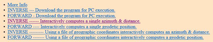
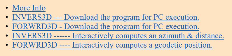
25 INVERSE/FORWARD/INVERS3D/FORWRD3D Computation Utilities Available at


26 Obtained using NGS Tool Kit Why doesn t BkAz = FwAz ± 180?
27 What is wrong with NAD 83? NAD 83 based on a nongeocentric reference system Off by about 2.2 m Note this is the best they could do with observations available in the early 80 s Not a mistake. Just a reality of not having GNSS GNSS works in a geocentric reference system relatable to a geocentric ITRF coordinate system
28 What is wrong with NAVD 88? NAVD 88 is both biased (by about one-half meter) and tilted (about 1 meter coast to coast) relative to the best global geoid models available today U.S. uses a hybrid geoid today Not a best fit to the topographic surface for the U.S.
29 What is being done? Geometric model has New geometric 4D horizontal datum based on GRS 80 ellipsoid Latitude, φ Longitude, λ Geodetic height, h Time, t 0 Geometric model relies on the CORS network

30 What is being done? Why time, t 0? Because plate tectonics, coordinates of stations change over time GNSS can detect these motions Why CORS stations have velocity vectors related to them In this area, coordinates change by a few centimeters each year

31 WIL1 Position and Velocity

32 Approximate Shifts in Horizontal Datum Horizontal coordinates will change from 0.5 m to 1.5 m across the U.S. New horizontal datum in PA will be called the North American Terrestrial Reference Frame of 2022 (NATRF2022) Three others will be created according to tectonic plates in 2022

33 Approximate Shifts in Heights Can vary from 0 m to 1.3 m in U.S. New vertical datum will be called the North American- Pacific Geopotential Datum of 2022 (NAPGD2022) Will use GEOID 2022
 model of Earth Vertical model Geopotential model closely aligns with surface of Earth Based on variations in")
34 What is being done? Ellipsoid is a best fit of geopotential (gravitybased) model of Earth Vertical model Geopotential model closely aligns with surface of Earth Based on variations in gravity Relies on spaceborne gravity observations (long wavelength) GRAV-D program, (medium wavelegth) terrestrial gravity observations (short wavelength)
35 A New State Plane Coordinate System State Plane Coordinate System of 2022 Referenced to a 202x Terrestrial Reference Systems (TRFs) Based on the same ellipsoid of GRS 80 Same three conformal mapping systems Lambert Conformal Conic (LCC) used in PA Transverse Mercator (TM) Oblique Mercator (OM) Will be set to fit topographic surface

36 A New State Plane Coordinate System From International Earth Rotation and Reference /ITRF/itrf.html IERS is a international consortium using GNSS, VLBI, and other techniques to define worldwide coordinate systems NGS plans to align new reference system to current at the time of creation of NA


37 Current Map Projection Systems used in SPCS 83

38 Surfaces in SPCS Note: Surface secant at standard parallels TM secant along two meridians Standard parallels Meridians where surface is secant to ellipse Scale exact means geodetic distance equal to grid distance
39 Components of Current LCC Map Projection Ellipsoidal parameters for GRS 80 Semimajor axis, a = 6,378,137.0 m Flattening factor, f = 1/ Eccentricity, e = Current zonal constants (Lambert conformal conic) Grid origin (φ 0, λ 0 ) Latitude of standard parallels North φ N and south φ S Origin offsets False easting, E 0, and false northing, N b

40 Components of the Secant Lambert Conformal Conic Projection Note: Zone limits only define extents where distance distortion is limited to some factor such as 1:10,000 or better Zones do not stop at limits! φ S φ N Standard Parallels
 distance and the geodetic (ellipsoid) distance")
41 Secant to ellipsoid! Current Projection Distance distortions refer to a comparison between the grid (map) distance and the geodetic (ellipsoid) distance However we work on the ground So distance distortion can be very large due to elevations (orthometric heights) of stations
42 Distance Reductions Must reduce horizontal distances to ellipsoid (geodetic) Horizontal distance ellipsoid Called elevation factor (EF) hi A A H 1 S D 1 Geoid B B h r From ellipsoid mapping surface Called scale factor (k) Combined factor = EF k = (CF) map distance = (horizontal distance)cf horizontal distance = map distance/cf h 1 N 1 N 2 D 2 D 3 h 2 θ O R

43 A New State Plane Coordinate System Based on same three map projection systems But a single-parallel system for Lambert Conformal Conic So mathematics slightly different
44 How Will They Do It? Instead of making developable surface secant to ellipsoid Increase radius of cone to bring it closer to topographic surface of Earth Elevation variation still limits its precision
45 SPCS 2022 Surface By increasing radius of cone, the mapping surface approaches the topographic suface Due to elevation variations in PA and size of PA, the fit to the surface is limited Ellipsoid Mapping surface
46 Does a Single Parallel LCC equal the Current System? Can check by determining scale factor at current central parallel in SPCS 83 PA North zone Defining parameters South standard parallel, φ S = North standard parallel, φ N = Grid origin, (φ 0, λ 0 ) = (N40 10, W77 45 ) False northing and easting: (0.000 m, 600, m)
47 Example In PA North zone for SPCS 83 Station A: (N , W ) Computed Northing Easting are: N = 127, m E = 745, m Can this be matched with a single-parallel LCC?
48 Example Equivalent single parallel system relies on scale factor at central parallel Central parallel for the PA SPCS 83 North zone of N Computed as φ CP = sin 1 2 ln cos φ S cos φ N 1 e 2 sin 2 φ N 1 e 2 sin 2 φ S ln 1+sin φ N 1 sin φ N ln 1+sin φ S 1 sin φ S +e ln 1+e sin φ S 1 e sin φ S ln 1+e sin φ N 1 e sin φ N SPCS 83, PA North zone scale factor at central parallel is This will be limited to 6 decimals in SPCS 2022 and will be > 1 in most cases This computation is only for the example and will be defined as part of SPCS 2022
49 Example So defining parameters for single parallel system are Central parallel, φ CP = N Grid origin, (φ 0, λ CM ) = (N 40 10, W ) Note that φ 0 = φ CP in SPCS 2022 Scale factor at φ CP, k 0 = False northing, N 0, and easting, E 0 : (0.000 m, 600, m) Note The NGS plans on placing the grid origin at the central parallel, thus reducing the number of defining parameters to five. This will result in a large False northing to remove possibility of negative coordinates.
50 Example Common functions for single parallel LCC map projection W φ = 1 e 2 sin 2 φ M φ = cos φ W(φ) T φ = 1 sin φ 1+sin φ 1+e sin φ 1 e sin φ e
51 Example Zone computations for PA North zone using single parallel w CP = W φ CP = m CP = M φ CP = t 0 = T φ 0 = ; Needed since SPCS83 origin not at CP t CP = T φ CP = n = sin φ CP = F = m CP nt n = CP R b = ρ t 0 = k CP aft n 0 = 7,379, m = k CP a m n Reduces number of zone constants from 11 to 5
52 Example Station computations t = T = m = M = R = ρ t = k 0 aft n = 7,252, m γ = n = N = R b R cos γ + N b = 127, m (Check!) E = R sin γ + E 0 = 745, m (Check!)
53 SPCS 2022 Defining parameters Only change to inverse computations will be to compute radius to station as R = N k CP cos γ = E 2 +N 2 k CP
54 SPCS 2022 Defining parameters So defining parameters will be Grid origin: (φ CP, λ CM ) Scale factor: k CP False Northing and Easting, N 0 and E 0 Note that N 0 will need to be large to avoid negative coordinates With fewer defining parameters and fewer computations
 and still provide overlap with southern zone and")
55 Preliminary Design for PA North Zone Grid Origin: (N 41 25, W ) k CP = (exact) False northing and easting? Unknown at this time, assume (600,000 m, 600,000 m)? For your consideration Going from to the western border, is about 232,752 m Offsets could be (350,000 m, 350,000 m) and still provide overlap with southern zone and western states
56 Comparison of Zone Constants Current North Zone Prelim. SPCS 2022 North Zone Parameter Value Parameter Value w w m m t t W M T N R b 7, m F t n F R b 7,379, m
57 Given: (φ, λ) Find: (N, E), k, γ Solution: n R = r ( ) = aft ( ) n 0 = N = R R cos + E k b = R sin + E Rn = = am m t mt n 1 n 1 0 Direct Problem Nb


58 Direct Problem Given: (N , W ) Find: (N, E), k, γ Solution: Parameters Values R 7,253, γ N 589, m E 745, m K
59 Distance Precision SPCS 2022 will use PPM s rather than distance precisions Converting Precision = PPM E.g. 100 PPM yields Precision = 100 1,000,000 = 1 10,000 Scale Factor = 1 PPM = 1 Precision E.g. 400 mm yields Scale factor = ,000,000 =
60 Examples PPM Precision Scale Factor 400 1: : :10, :12, :16, :25, :50, :
61 Distance Reductions Will 100, 80, 60, 40, be good enough? Depends on accuracy necessary for job Also may depend on equipment 1:10,000 is well below what today s instruments can achieve Today s instruments capable of 40 ppm or lower (better)
62 FGDC Control Standards For engineering and construction control surveys Engr & Constr Order Precision PPM 2 nd order, class 1 1:50, nd order, class 2 1:20, rd order, class 1 1:10, rd order, class 2 1:5, th order (Construction) 1:2,
63 What Reductions Will Be Necessary? Reduction of Distances Depends on required accuracy of survey and its location in zone Azimuths Definitely, due to convergence of the meridians Angles 1 mile east-west traverse at yields a 46 convergence in directions Depends on length of sight distance but probably not
64 Distance Reduction Elevation Factor Nothing changes: To reduce an observed horizontal distance to a geodetic distance, we need the elevation factor (EF) L e L m = R e R e +H+N = R e R e +h Then L e = R e R e +H+N L m = R e R e +h where R e = Radius of the Earth So EF = R e R e +H+N = R e R e +h L m
65 Distance Reduction Combining elevation factor with scale factor yields a combined factor CF = EF k L g = EF k L m = CF L m Using a project factor will yield better results Project factor is an average combined factor for project Project factor can be entered in controller as project scale factor
66 Direction Reduction All grid north are parallel to central meridian All geodetic north converge at the pole Convergence of meridians must be corrected when using grid or geodetic azimuths γ γ γ γ
67 Direction Reduction Computing a grid azimuth from a geodetic azimuth Az grid = Az geodetic γ γ Geodetic azimuth from a grid azimuth Az geodetic = Az grid + γ γ
68 Arc-to-Chord Correction A small correction that accounts for the projection of an arc on a plane surface Also known as the second-term correction Should be applied to all directions In SPCS 83 NGS recommended this correction for line over 8-km in length Dated: To match 1 -instrumentation lines over 2 km but where can you see that far anyway?
69 Planning for Upcoming Changes NGS will provide transformation tools but Accuracy of transformation tools based on heights dependent on GPS on Benchmarks program Horizontal accuracies will always be better by readjusting the original data Learn to save the observations What will it take for you to change an existing project?
70 Planning for Upcoming Changes State and local laws and contracts may require SPCS 83 (NAD 83 positions) or NAVD 88 heights These must be changed By 2022 Suggest change it so that it says the most recent nationally recognized state plane coordinate system and height systems rather than a specific item such as SPCS 2022 What will it take to change these in your locality?

71 Things that need our attention Definition of the foot Survey foot? 1 ft = ത3 m This definition has led to multiple errors since its creation International foot? 1 ft = m States in green adopted international foot in SPCS 83 Meters?
72 Planning for Upcoming Changes Number of Zones? Currently there are north (3701) and south (3702) zones North zone extends to international border in Lake Erie. Why? Does not support a statewide GIS nor a statewide coordinate system PA about mi from Mason- Dixon line to PA North border Approximately 158 mi yields 1:10,000 ~ 175 mi to very tip of Erie county ~157.2 mi
73 Planning for Upcoming Changes Number of Zones? Maintain current 1:10,000 precision? Precision compares ellipsoid versus map distance Not ground versus map Heights of lines require distance reductions Enlarge cone to achieve precisions closer to ground distances? NGS default

74 Planning for Upcoming Changes Number of Zones? State and local organizations will benefit by having only 1 zone Will provide a common map coordinate system for the Commonwealth Create three different systems? Two-zone North-South system (NGS) Statewide

75 Prelimnary SPCS 2022 System Default design will mimic current two-zone system However, designed with respect to topographic surface North zone has a range of +102 to 99 ppm Or about 1/10,000 with topographic surface
76 Planning for Upcoming Changes NGS allows two different state plane coordinate systems for each state Currently being done in KY That is, a multiple-zone (North-South in PA) system To support local surveying and engineering projects And a single-zone system To support statewide mapping and planning projects
77 Planning for Upcoming Changes Note danger of two different systems is confusion about basis for a set of coordinates E.g. (203, , 634, ) Are these from the single- or multi-zone system??? Thus documentation(meta data) will be paramount May be also handled by designing a system that will make the origin of the coordinates by using very different offsets. i.e. false northing and easting E.g. (350,000 m, 350,000 m) for dual-zone Single-zone (600,000 m, 600,000 m)
78 Planning for Upcoming Changes Two well-designed systems should satisfy all users However, two different systems will not occur without consensus and input from stakeholders!
79 Planning for Upcoming Changes Stakeholders that can give input to desired changes or not in SPCS 2022 when compared to SPCS 83 State organization such as PennDOT, surveying and engineering societies such as the PSLS, professional geospatial organizations such as the GEOSPATIAL Consortium, and universities that perform geospatial education or research such as Penn State
80 Poll Questions? Definition of length unit Survey foot? International foot? International system (metric) Who has legislation that specifies SPCS 83 or NAD 83? How many have contacted the appropriate people to change this?
81 Poll Questions How many systems should we have? Dual- and single-zone system Dual-zone system only Single-zone system only False northing and easting values?
82 Poll Questions Has your Chapter discussed this? Is PSLS leadership actively pursuing 1. Forming a consortium of people to discuss changes Who is working on modifying legislation? Yes No 1. Yes No Don t know Know Don t Are you concerned about upcoming changes? Yes No
83 Poll Questions How prepared are you for the upcoming changes? Prepared Somewhat prepared Unprepared How prepared is your company for the upcoming changes? Prepared Somewhat prepared Unprepared Prepared Somewhat Unprepared Prepared Somewhat Unprepared
84 Further Study Ghilani, C Elementary Surveying: An Introduction to Geomatics,16 th Edition Chapter 20. Prentice Hall, Upper Saddle River, NJ. Observation reductions Low-distortion projections Single project factor Crossing zones
85 If a man empties his purse into his head, no man can take it away from him. An investment in knowledge always pays the best interest. - Benjamin Franklin 86

86 End of Class!!!
The Future of SPCS in 2022
 The Future of SPCS in 2022 Charles Chuck Ghilani, Ph.D. Professor Emeritus Pennsylvania State University Class Etiquette Turn off all cell phones Or set them to vibrate Go out of the room to answer any
Control Surveys and Coordinate Systems
 Control Surveys and Coordinate Systems The Earth is Round Basic Shape of the Earth: Oblate Spheroid of Revolution The length of the equatorial axis is approximately 27 miles greater than the polar axis.
ch02.pdf chap2.pdf chap02.pdf
 Introduction to Geographic Information Systems 8th Edition Karl Solutions Manual Full Download: http://testbanklive.com/download/introduction-to-geographic-information-systems-8th-edition-karl-solutions-manu
NATRF 2022 AND LDP OCTOBER 11, 2017
 NATRF 2022 AND LDP OCTOBER 11, 2017 MODERNIZATION OF THE NSRS Why? Leaving passive control marks behind and relying solely on the CORS network for 3D positions: Older methodology relies on terrestrial
MODERNIZATION OF THE NSRS
 NATRF 2022 AND LDP SEPTEMBER 12, 2017 MODERNIZATION OF THE NSRS Why? Leaving passive control marks behind and relying solely on the CORS network for 3D positions: Older methodology relies on terrestrial
VT State Plane. Daniel J. Martin National Geodetic Survey VT Geodetic Advisor. VSLS Conference Rutland VT April 11, 2008
 VT State Plane Daniel J. Martin National Geodetic Survey VT Geodetic Advisor VSLS Conference Rutland VT April 11, 2008 Today s Outline Define the problem Review of VT State Plane System Relationship
Ground Truth Annual Conference. Optimized Design of Low Distortion Projections. Michael L. Dennis, RLS, PE
 Arizona Professional Land Surveyors Association 016 Annual Conference Ground Truth Optimized Design of Low Distortion Projections Michael L. Dennis, RLS, PE Version 3 (rev 1), May 016 Design and metadata
Solving the "Grid to Ground Problem" with Custom Coordinate Systems CV327-6 About the Speaker:
 Solving the "Grid to Ground Problem" with Custom Coordinate Systems Richard Sincovec, LSI Director of Technology, Edward James Surveying President, Quux Software CV327-6 Grid projections such as the State
Lecture 2. Map Projections and GIS Coordinate Systems. Tomislav Sapic GIS Technologist Faculty of Natural Resources Management Lakehead University
 Lecture 2 Map Projections and GIS Coordinate Systems Tomislav Sapic GIS Technologist Faculty of Natural Resources Management Lakehead University Map Projections Map projections are mathematical formulas
Ground Truth Annual Conference. Design and Documentation of Low Distortion Projections for Surveying and GIS
 Professional Land Surveyors of Oregon 15 Annual Conference Ground Truth Design and Documentation of Low Distortion Projections for Surveying and GIS Michael L Dennis, RLS, PE v. (rev 1), January 15, Design
Shape e o f f the e Earth
 1 Coordinate Systems & Projections Coordinate Systems Two map layers are not going to register spatially unless they are based on the same coordinate system. 2 Contents Shape of the earth Datum Projections
The U.S. National Spatial Reference System in 2022
 Presented at the, May 29 - June 2, 2017 in The U.S. National Spatial Reference System in 2022 Daniel R. Roman, (Chief Geodesist) NOAA s National Geodetic Survey 1 Why change? Outline Naming conventions
Map Projections. What does the world look like? AITOFF AZIMUTHAL EQUIDISTANT BEHRMANN EQUAL AREA CYLINDRICAL
 Map Projections What does the world look like? AITOFF AZIMUTHAL EQUIDISTANT BEHRMANN EQUAL AREA CYLINDRICAL 1 CYLINDRICAL EQUAL AREA BONNE CRASTER PARABOLIC 2 ECKERT I ECKERT III ECKERT V There are many
Lesson 5: Map Scale and Projections
 Organizing Data and Information Lesson 5: Map Scale and Projections Map Scales Projections Information can be organized as lists, numbers, tables, text, pictures, maps, or indexes. Clusters of information
Geographic coordinate systems
 1 Geographic coordinate systems In this chapter you ll learn about longitude and latitude. You ll also learn about the parts that comprise a geographic coordinate system including Spheres and spheroids
WHERE ARE YOU? Maps & Geospatial Concepts Fall 2012
 WHERE ARE YOU? Maps & Geospatial Concepts Fall 2012 Where are you? Relative location I m at school Absolute Location 45 26 18.07 122 43 50.78 Datums Datums A reference surface of the Earth Used as the
Map projections. Rüdiger Gens
 Rüdiger Gens Coordinate systems Geographic coordinates f a: semi-major axis b: semi-minor axis Geographic latitude b Geodetic latitude a f: flattening = (a-b)/a Expresses as a fraction 1/f = about 300
WHERE ARE YOU? Maps & Geospatial Concepts Fall 2015
 WHERE ARE YOU? Maps & Geospatial Concepts Fall 2015 Where are you? Relative location I m at school Absolute Location 45 26 18.07 122 43 50.78 Where is Boston? Introducing Geodesy, Ellipsoids & Geoids Geodesy
This week s topics. Week 6. FE 257. GIS and Forest Engineering Applications. Week 6
 FE 257. GIS and Forest Engineering Applications Week 6 Week 6 Last week Chapter 8 Combining and splitting landscape features and merging GIS databases Chapter 11 Overlay processes Questions? Next week
What is a Map Projection?
 What is a Map Projection? It is how we represent a three dimensional Earth on a flat piece of paper However The process of transferring information from the Earth to a map causes every projection to distort
Georeferencing. Place names Postal addresses Postal codes Coordinate systems (lat/long, UTM, etc.)
") Georeferencing Georeferencing Used to describe the act of assigning locations to data or information Certain requirements include that they are: unique, have shared meaning, and are persistent through
Georeferencing Georeferencing Used to describe the act of assigning locations to data or information Certain requirements include that they are: unique, have shared meaning, and are persistent through
Height systems. Rudi Gens Alaska Satellite Facility
 Rudi Gens Alaska Satellite Facility Outline Why bother about height systems? Relevant terms Coordinate systems Reference surfaces Geopotential number 2 Why bother about height systems? give a meaning to
4 Survey Datums. 4.1 Horizontal Datum Policy SURVEY DATUMS SEPTEMBER 2006
 4 Survey Datums Today s multi-organizational Project Development efforts require the use of common, accurate horizontal and vertical survey datums and consistent, precise control-survey procedures to ensure
Modernization of the National Spatial Reference System 2022 Datum. Jacksonville Chapter July 2018
 Modernization of the National Spatial Reference System 2022 Datum Jacksonville Chapter July 2018 Randy Tompkins, PSM, PLS Geomatics Project Manager Surveyor, Hydrographer, & Geodesist DRMP, Inc. Jacksonville,
A PRIMER ON COORDINATE SYSTEMS Commonly Used in Michigan
 A PRIMER ON COORDINATE SYSTEMS Commonly Used in Michigan David P. Lusch, Ph.D., GISP Department of Geography Remote Sensing & GIS Research and Outreach Services Group Michigan State University September,
Frames for the Future New Datum Definitions for Modernization of the U.S. National Spatial Reference System
 Figure 10. Horizontal position differences (in meters) between NAD 83 and ITRF 08 at time 2022.00 (January 1, 2022). Positional differences are shown for the North American and Pacific tectonic plates.
Georeferencing, Map Projections, Cartographic Concepts. -Coordinate Systems -Datum
 Georeferencing, Map Projections, Cartographic Concepts -Map Projections -Coordinate Systems -Datum Map projection is "the process of systematically transforming positions on the Earth's spherical surface
Map Projections. Displaying the earth on 2 dimensional maps
 Map Projections Displaying the earth on 2 dimensional maps Map projections Define the spatial relationship between locations on earth and their relative locations on a flat map Are mathematical expressions
GISC3325 Spring 2011 Final Exam
 GISC3325 Spring 2011 Final Exam Name: Carefully read each question. Identify the important elements and the question being asked. Show your work for partial credit. No credit for undocumented wrong answers.
Outline. Shape of the Earth. Geographic Coordinates (φ, λ, z) Ellipsoid or Spheroid Rotate an ellipse around an axis. Ellipse.
 Ellipsoid or Spheroid Rotate an ellipse around an axis. Ellipse.") Map Projections Outline Geodesy and map projections Prof. D. Nagesh Kumar Department of Civil Engineering Indian Institute of Science Bangalore 560 012, India http://www.civil.iisc.ernet.in/~nagesh Shape
Map Projections Outline Geodesy and map projections Prof. D. Nagesh Kumar Department of Civil Engineering Indian Institute of Science Bangalore 560 012, India http://www.civil.iisc.ernet.in/~nagesh Shape
Lecture 4. Coordinate Systems & Projections
 Lecture 4 Coordinate Systems & Projections Outline Geodesy Geoids Ellipsoids Geographic Coordinate Systems Magnetic North vs. True North Datums Projections Applying Coordinate Systems and Projections Why
How does an ellipsoid differ from a sphere in approximating the shape and size of the Earth?
 Chapter 02 Test Bank Worksheet Questions 1. What is a map projection? Topic: Map Projection 2. How does an ellipsoid differ from a sphere in approximating the shape and size of the Earth? Topic: Ellipsoid
April 24, :00 to 5:00 p.m.
 Datums, Coordinate Systems, Low Distortion Projections (LDP), & the Global Spatial Data Model (GSDM) Hosted by: City of Las Cruces Public Works/Project Development and Community Development/GIS April 24,
Boolean Operators and Topological OVERLAY FUNCTIONS IN GIS
 Boolean Operators and Topological OVERLAY FUNCTIONS IN GIS Query asking a question of the attribute data Standard Query Language (SQL) is used to query the data There are 4 basic statements used to get
BUILDING AN ACCURATE GIS
 BUILDING AN ACCURATE GIS 2006 GIS in the Rockies Denver, Colorado September 13, 2006 William E. Linzey United States Department of Commerce National Oceanic and Atmospheric Administration National Geodetic
Coordinate Systems. Location on earth is defined by coordinates
 Coordinate Systems We think of the earth as a sphere It is actually a spheroid (ellipsoid), slightly larger in radius at the equator than at the poles Shape of the Earth Location on earth is defined by
Understanding Projections for GIS
 Presented by John Schaeffer Juniper GIS Services, Inc. This PowerPoint is available at JuniperGIS.com Presentation Objectives To understand basic concepts on projections and coordinate systems for the
EnvSci360 Computer and Analytical Cartography
 EnvSci360 Computer and Analytical Cartography Lecture 3 Geodesy Map Projections, Datums, and Coordinate Systems 1 Geodesy The science of measuring and representing the shape and size of the earth, and
The Elements of GIS. Organizing Data and Information. The GIS Database. MAP and ATRIBUTE INFORMATION
 GIS s Roots in Cartography Getting Started With GIS Chapter 2 Dursun Z. Seker MAP and ATRIBUTE INFORMATION Data (numbers and text) store as files refer to them collectively as a database gather inform.
The 3-D Global Spatial Data Model: Geometrical Foundation of the Global Spatial Data Infrastructure
 The 3-D Global Spatial Data Model: Geometrical Foundation of the Global Spatial Data Infrastructure Earl F. Burkholder, PS, PE Annotated Table of Contents July 8,2006 I. The Global Spatial Data Model (GSDM)
NR402 GIS Applications in Natural Resources Lesson 4 Map Projections
 NR402 GIS Applications in Natural Resources Lesson 4 Map Projections From http://www.or.blm.gov/gis/ 1 Geographic coordinates Coordinates are expressed as Latitude and Longitude in Degrees, Minutes, Seconds
Introduction to Geographic Information Science. Updates/News. Last Lecture. Geography 4103 / Map Projections and Coordinate Systems
 Geography 4103 / 5103 Introduction to Geographic Information Science Map Projections and Coordinate Systems Updates/News Thursday s lecture Reading discussion 1 find the readings online open questions,
Geo Referencing & Map projections CGI-GIRS 0910
 Geo Referencing & Map projections CGI-GIRS 0910 Where are you? 31UFT8361 174,7 441,2 51 58' NB 5 40' OL 2/60 Who are they? 3/60 Do geo data describe Earth s phenomena perfectly? Georeference systems ellipsoid
HORIZONTAL PROJECTION PARAMETERS: DANE COUNTY COORDINATES
 Recommended RTK GPS Configuration Parameters for the City of Madison, WI Base Station Compiled by: Dan Rodman RLS, City of Madison (608)266-6674 drodman@cityofmadison.com For base station information see
Height systems. Rüdiger Gens
 Rüdiger Gens 2 Outline! Why bother about height systems?! Relevant terms! Coordinate systems! Reference surfaces! Geopotential number! Why bother about height systems?! give a meaning to a value defined
Analytical and Computer Cartography Lecture 3: Review: Coordinate Systems
 Analytical and Computer Cartography Lecture 3: Review: Coordinate Systems Geographic Coordinates NAD83 NAD27 remained in use until the earthcentered international GRS80 was complete (Geodetic Reference
Projections and Coordinate Systems
 Projections and Coordinate Systems Overview Projections Examples of different projections Coordinate systems Datums Projections Overview Projections and Coordinate Systems GIS must accurately represent
NGS is Scheduled to Replace NAVD 88 and NAD 83 In 2022
 NGS is Scheduled to Replace NAVD 88 and NAD 83 In 2022 Indiana Society of Professional Land Surveyors Conference January 2017 John Ellingson NGS Geodetic Advisor john.ellingson@noaa.gov 202-306-6904 1
12/26/2012. Geographic Information Systems * * * * GIS (... yrezaei
 ( - Geographic Information Systems ( ( 1 2 3 Information System Data base DB IS IS DB (Knowledge ( ( (System (Information System - (Georefrence Analysis Data + Knowledge ======== Information 4 5 ( < 10%
Geo Referencing & Map projections CGI-GIRS 0910
 Geo Referencing & Map projections CGI-GIRS 0910 Where are you? 31UFT8361 174,7 441,2 51 58' NB 5 40' OL 2/60 Who are they? 3/60 Do geo data describe Earth s phenomena perfectly? Georeference systems ellipsoid
Applied Cartography and Introduction to GIS GEOG 2017 EL. Lecture-1 Chapters 1 and 2
 Applied Cartography and Introduction to GIS GEOG 2017 EL Lecture-1 Chapters 1 and 2 What is GIS? A Geographic Information System (GIS) is a computer system for capturing, storing, querying, analyzing and
Projections & GIS Data Collection: An Overview
 Projections & GIS Data Collection: An Overview Projections Primary data capture Secondary data capture Data transfer Capturing attribute data Managing a data capture project Geodesy Basics for Geospatial
Importance of Understanding Coordinate Systems and Map Projections.
 Importance of Understanding Coordinate Systems and Map Projections. 1 It is extremely important that you gain an understanding of coordinate systems and map projections. GIS works with spatial data, and,
HP-35s Calculator Program Lambert 1
 Convert Latitude and Longitude to Lambert Conformal Conic Projection Co-ordinates (SPCS) Programmer: Dr. Bill Hazelton Date: July, 2010. Version: 1.2 Line Instruction Display User Instructions N001 LBL
Modern Navigation. Thomas Herring
 12.215 Modern Navigation Thomas Herring Today s Class Latitude and Longitude Simple spherical definitions Geodetic definition: For an ellipsoid Astronomical definition: Based on direction of gravity Relationships
Lab #3 Map Projections.
 Lab #3 Map Projections http://visual.merriam-webster.com/images/earth/geography/cartography/map-projections.jpg Map Projections Projection: a systematic arrangement of parallels and meridians on a plane
Intro to GIS Fall 2010 Georeferencing & Map Projections
 Intro to GIS Fall 2010 Georeferencing & Map Projections SHAPE OF THE EARTH Earth's Shape Geoid: shape of earth minus topographic features (irregular due to local variations in gravity) Ellipsoid: elongated
When the Earth Was Flat. Measurements were made using a plumb bob, a spirit level, and a stick. Also, the Stars.
 ABSTRACT Defining the shape of the Earth geoid. Mathematical models spheroid or ellipsoid Mathematical projection of geodetic systems GIS/GPS technology The need for a unified projection systems World
1. Geospatial technology rarely links geospatial data to nonspatial data. a. True *b. False
 Chapter 2 Where in the Geospatial World Are You? 1. Geospatial technology rarely links geospatial data to nonspatial data. 2. For geospatial technology to work, every location on Earth must be: a. inhabited
SPCS2022 in North Carolina
 SPCS2022 in North Carolina New State Plane Coordinate System in 2022 Will replace SPCS 83 Referenced to new terrestrial reference frames Two conflicting desires for SPCS2022 coordinates: Change coordinates
Coordinate Systems and Datum Transformation in ArcGIS. Brittney White and Melita Kennedy
 Coordinate Systems and Datum Transformation in ArcGIS Brittney White and Melita Kennedy Where is my data? Problem Horizontal Vertical Projections Transformations Horizontal coordinate systems Geographic
Geodetics: Implications for GIS Professionals May 10, 2018
 Experts in Geomatics, Surveying, Positioning, Geospatial Data, and Mapping Sciences Geodetics: Implications for GIS Professionals May 10, 2018 Michael Barnes APSG Education Foundation Chair 2010-2020 APSG
New Datums: Replacing NAVD 88 and NAD 83
 New Datums: Replacing NAVD 88 and NAD 83 By Dave Zenk PE, LS National Geodetic Survey Northern Plains Regional Advisor 1735 Lake Drive West Chanhassen, MN 55317-8581 952-368-2548 office 612-414-9522 mobile
What is Geodesy? Types of Geodesy terrestrial or classical geodesy space geodesy theoretical geodesy
 What is Geodesy? Geodesy is the study of: The size, shape and motion of the earth The measurement of the position and motion of points on the earth's surface, and The study of the earth's gravity field
Lecture 10-14: Map Projections and Coordinate System
 URP 1281 Surveying and Cartography Lecture 10-14: Map Projections and Coordinate System December 27, 2015 Course Teacher: Md. Esraz-Ul-Zannat Assistant Professor Department of Urban and Regional Planning
Notes on Projections Part II - Common Projections James R. Clynch February 2006
 Notes on Projections Part II - Common Projections James R. Clynch February 2006 I. Common Projections There are several areas where maps are commonly used and a few projections dominate these fields. An
Projections Part I - Categories and Properties James R. Clynch February 2006
 I. Introduction and References Projections Part I - Categories and Properties James R. Clynch February 2006 The world is, approximately, a sphere. Maps are flat. Making maps requires some method of putting
Shape of the Earth. Data Output by the Receiver
 It is quite common for confusion to arise about the process used during a hydrographic survey when GPS-derived water surface elevation is incorporated into the data as an RTK Tide correction. This article
Geographic Information Systems class # 1 February 19, Coordinate reference systems in GIS: geodetic coordinates
 Geographic Information Systems class # 1 February 19, 2013 Coordinate reference systems in GIS: geodetic coordinates Manuel Campagnolo ISA Manuel Campagnolo (ISA) GIS/SIG 2012 2013 February 19, 2013 1
HP-35s Calculator Program Lambert 2
 Convert Lambert Conformal Conic Projection Co-ordinates (SPCS) to Latitude and Longitude Programmer: Dr. Bill Hazelton Date: September, 2010. Version: 1.1 Mnemonic: L for Lambert to Latitude and Longitude
REFERENCING COORDINATE SYSTEMS MAP PROJECTIONS GEOREFERENCING
 GIS in Ecology SPATIAL REFERENCING COORDINATE SYSTEMS MAP PROJECTIONS GEOREFERENCING : :1 Where on earth? Early mapmakers recognized the need for a system that could locate features on the earth's surface.
NGS and the Modernization of the National Spatial Reference System (NSRS)
") NGS and the Modernization of the National Spatial Reference System (NSRS) Dr. Dana Caccamise Pacific Southwest Region (CA,NV) Geodetic Advisor dana.caccamise@noaa.gov NOAA s National Geodetic Survey geodesy.noaa.gov
NGS and the Modernization of the National Spatial Reference System (NSRS) Dr. Dana Caccamise Pacific Southwest Region (CA,NV) Geodetic Advisor dana.caccamise@noaa.gov NOAA s National Geodetic Survey geodesy.noaa.gov
GPS Remote Sensing. GIS Photogrammetry. GEODESY Equipment (total station) CARTOGRAPHY Survey Software. Map Projection Coordinate Systems
 CARTOGRAPHY Survey Software. Map Projection Coordinate Systems") GPS Remote Sensing GIS Photogrammetry GEODESY Equipment (total station) CARTOGRAPHY Survey Software Map Projection Coordinate Systems 1 Coordinate Systems, Datum and Map Projection Dr. Maher A. El-Hallaq
GPS Remote Sensing GIS Photogrammetry GEODESY Equipment (total station) CARTOGRAPHY Survey Software Map Projection Coordinate Systems 1 Coordinate Systems, Datum and Map Projection Dr. Maher A. El-Hallaq
Georeferencing. datum. projection. scale. The next few lectures will introduce you to these elements. on the Earth, you ll need to understand how
 Georeferencing GOAL: To assign a location to all the features represented in our geographic information data In order to do so, we need to make use of the following elements: ellipsoid/geoid To determine
GEOID UNDULATIONS OF SUDAN USING ORTHOMETRIC HEIGHTS COMPARED WITH THE EGM96 ANG EGM2008
 GEOID UNDULATIONS OF SUDAN USING ORTHOMETRIC HEIGHTS COMPARED Dr. Abdelrahim Elgizouli Mohamed Ahmed* WITH THE EGM96 ANG EGM2008 Abstract: Positioning by satellite system determine the normal height above
Fundamentals of Surveying (LE/ESSE )
") Fundamentals of Surveying (LE/ESSE 2620 3.0) Lecture 2 Basics of Surveying Dr.-Ing. Jian-Guo Wang Geomatics Engineering York University Fall 2017 1 2-1. Overview Part 1: Basics - The Earth s Shape & Size.
Fundamentals of Surveying (LE/ESSE 2620 3.0) Lecture 2 Basics of Surveying Dr.-Ing. Jian-Guo Wang Geomatics Engineering York University Fall 2017 1 2-1. Overview Part 1: Basics - The Earth s Shape & Size.
U.S. Datums: Where We ve Been,
 U.S. Datums: Where We ve Been, Where We re Going Modernizing the National Spatial Reference System Matt Wellslager RFA, South Carolina Geodetic Survey Presentation Outline 1. - Introductions. 2. - National
HP-35s Calculator Program TM 1
 Convert Latitude and Longitude to Transverse Mercator Co-ordinates (UTM, SPCS, etc.) Programmer: Dr. Bill Hazelton Date: April, 2008. Version: 1.0 Mnemonic: T for Transverse Mercator Line Instruction Display
GIST 3300 / Geographic Information Systems. Last Time. Today
 GIST 3300 / 5300 Last Time Ellipsoids and Datums Today Map Projections Map Projections Today we will build on the concepts of Geographic Coordinate Systems, Ellipsoids and Datums and add the concepts of
2. GETTING STARTED WITH GIS
 2. GETTING STARTED WITH GIS What are geographic information systems and what are they used for? ArcGIS: ArcMap, ArcCatalog and ArcToolbox Vector data vs. raster data vs. attribute tables Polygons, polylines,
GEOGRAPHIC COORDINATE SYSTEMS
 GEOGRAPHIC COORDINATE SYSTEMS Introduction to GIS Winter 2015 What is Georeferencing? Used to establish a location on the Earth s surface 1 st order polynomial transformation Georeferencing toolbar What
Dr. ABOLGHASEM AKBARI Faculty of Civil Engineering & Earth Resources, University Malaysia Pahang (UMP)
") Workshop on : Dr. ABOLGHASEM AKBARI Faculty of Civil Engineering & Earth Resources, University Malaysia Pahang (UMP) 14-15 April 2016 Venue: Tehran, Iran GIS definitions GIS: A simplified view of the real
Workshop on : Dr. ABOLGHASEM AKBARI Faculty of Civil Engineering & Earth Resources, University Malaysia Pahang (UMP) 14-15 April 2016 Venue: Tehran, Iran GIS definitions GIS: A simplified view of the real
HP-33S Calculator Program TM 2
 Convert Latitude and Longitude to Transverse Mercator Co-ordinates (UTM, SPCS, etc.) Programmer: Dr. Bill Hazelton Date: April, 2008. Version: 1.0 Mnemonic: T for Transverse Mercator Line Instruction Display
Modern Navigation. Thomas Herring
 12.215 Modern Navigation Thomas Herring Today s class Map Projections: Why projections are needed Types of map projections Classification by type of projection Classification by characteristics of projection
Map projections. Rüdiger Gens
 Rüdiger Gens 2 Outline! Relevant terms! Why map projections?! Map projection categories " Projection surfaces " Features preserved from distortions! Map projection examples! Right choice Relevant terms!
The National Spatial Reference System of the Future
 The National Spatial Reference System of the Future William Stone Southwest Region (AZ, NM, NV, UT) Geodetic Advisor william.stone@noaa.gov NOAA s National Geodetic Survey geodesy.noaa.gov Salt Lake City
Welcome to Lesson 4. It is important for a GIS analyst to have a thorough understanding of map projections and coordinate systems.
 Welcome to Lesson 4. It is important for a GIS analyst to have a thorough understanding of map projections and coordinate systems. A GIS without coordinates would simply be a database like Microsoft Excel
MSGIC Spring Mtg Denton April 23, 2014
 Modernization of the National Spatial Reference System Keeping Pace with Changes in Positioning Technology and User Expectations in a Dynamic World MSGIC Spring Mtg Denton April 23, 2014 Dave Doyle Base
ELECTRONICS DIVISION INTERNAL REPORT NO. 324
 NATIONAL RADIO ASTRONOMY OBSERVATORY Green Bank, West Virginia ELECTRONICS DIVISION INTERNAL REPORT NO. 324 NRAO 43m Antenna Coordinates and Angular Limits (Version 4) Glen Langston September 14, 2012
Chapter 3: Configuring Geodetics & Units
 Chapter 3: Configuring Geodetics & Units WinFrog provides you with the ability to configure the Working Geodetics to suit survey requirements for almost any location worldwide. The configuration of the
Spatial Reference Systems. Introduction
 Spatial Reference Systems Wolfgang Kainz Professor of Cartography and Geoinformation Department of Geography and Regional Research University of Vienna wolfgang.kainz@univie.ac.at Introduction Historic
Fusion of Geodesy and GIS at NOAA s National Geodetic Survey
 Fusion of Geodesy and GIS at NOAA s National Geodetic Survey Esri Survey Summit July 6-9, 2013 San Diego, CA Michael Dennis, RLS, PE michael.dennis@noaa.gov The Plan Background NGS Data Explorer New Datasheet
Preventing Coordinate- System Confusion (maybe?)
") Preventing Coordinate- System Confusion (maybe?) Montana Association of Registered Land Surveyors 2008 Convention Bozeman, Montana 07 & 08 February 2008 Glenn Borkenhagen Inland GPS Inc. - Cody, Wyoming
Preventing Coordinate- System Confusion (maybe?) Montana Association of Registered Land Surveyors 2008 Convention Bozeman, Montana 07 & 08 February 2008 Glenn Borkenhagen Inland GPS Inc. - Cody, Wyoming
GPS Surveying Dr. Jayanta Kumar Ghosh Department of Civil Engineering Indian Institute of Technology, Roorkee. Lecture 06 GPS Position
 GPS Surveying Dr. Jayanta Kumar Ghosh Department of Civil Engineering Indian Institute of Technology, Roorkee Lecture 06 GPS Position Friends! Welcome you to sixth class on GPS surveying. Today, I am going
Map Projections & Coordinate Systems
 Map Projections & Coordinate Systems 9/7/2017 1 Why? Laying the Earth Flat Need convenient means of measuring and comparing distances, directions, areas, shapes. Traditional surveying instruments measure
GEOIDS FAQ. November
 GEOIDS FAQ 1. What is a geoid? A geoid is a representation of the equipotential surface of the Earth s gravity field. It can be thought of as a surface coinciding with the undisturbed mean sea level extended
LEADS. The Essential Elements of a 3-D Geographic Coordinate
 The Essential Elements of a 3-D Geographic Coordinate John W. Dix 13 September 2005 ESRI Homeland Security GIS Summit - Denver, CO John.W.Dix@nga.mil NATIONAL GEOSPATIAL-INTELLIGENCE AGENCY Overview is
Low Distortion Projections Part 2 Ground versus Grid
 Blue Marble Geographic Calculator provides an incredible variety of tools for working with an infinite combination of datums and projections. Shown here, I ve entered the parameters for a Low Distortion
1/28/16. EGM101 Skills Toolbox. Oblate spheroid. The shape of the earth Co-ordinate systems Map projections. Geoid
 EGM101 Skills Toolbox Oblate spheroid The shape of the earth Co-ordinate systems Map projections The geoid is the shape that the surface of the oceans would take under the influence of Earth's gravitation
Geographers Perspectives on the World
 What is Geography? Geography is not just about city and country names Geography is not just about population and growth Geography is not just about rivers and mountains Geography is a broad field that