The U.S. National Spatial Reference System in 2022
|
|
|
- Cody Robinson
- 6 years ago
- Views:
Transcription

1 Presented at the, May 29 - June 2, 2017 in The U.S. National Spatial Reference System in 2022 Daniel R. Roman, (Chief Geodesist) NOAA s National Geodetic Survey 1
2 Why change? Outline Naming conventions of NSRS 2022 Geometric component Regional Terrestrial Reference Frames Intra Frame Velocity Models Geopotential component Static Time-varying Future Plans and Summary 2
3 NGS Vision Everyone accurately knows where they are and where other things are anytime, anyplace. NGS 10 Year and Strategic Plans provide a more detailed description of NGS and the vision for the future looking ten years out. 3
4 Replace NAD 83 Simplified concept of NAD 83 vs Earth s Surface h NAD83 h 2022 f NAD83 f 2022 l NAD83 l 2022 h NAD83 h origin all vary smoothly by latitude and longitude NAD 83 origin 4

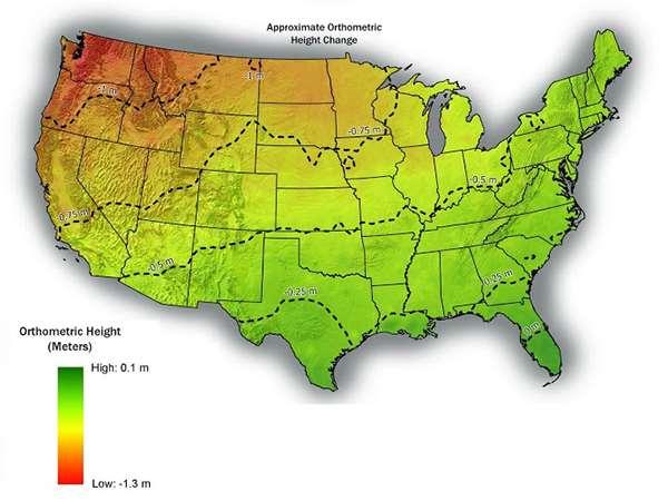
5 Vertical Shifts Ellipsoidal Orthometric 5
6 Why change? Outline Naming conventions of NSRS 2022 Geometric component Regional Terrestrial Reference Frames Intra Frame Velocity Models Geopotential component Static Time-varying Future Plans and Summary 6
7 NSRS Modernization The Old: NAD 83(2011) NAD 83(PA11) NAD 83(MA11) The New: The North American Terrestrial Reference Frame of 2022 (NATRF2022) The Caribbean Terrestrial Reference Frame of 2022 (CATRF2022) The Pacific Terrestrial Reference Frame of 2022 (PATRF2022) The Mariana Terrestrial Reference Frame of 2022 (MATRF2022) 7
8 NSRS Modernization Orthometric Heights Normal Orthometric Heights Dynamic Heights Gravity Geoid Undulations The Old: NAVD 88 PRVD 02 VIVD09 ASVD02 NMVD03 GUVD04 IGLD 85 IGSN71 GEOID12B DEFLEC12B Deflections of the Vertical The New: The North American-Pacific Geopotential Datum of 2022 (NAPGD2022) - Will include GEOID2022 8
9 NSRS Modernization The Old: Bluebooking (PAGES, ADJUST, B files, G files, FORTRAN) The New: OPUS-Projects for Everything GPS/GNSS Leveling Traverse Gravity RTK/RTN More? 9
10 Why change? Outline Naming conventions of NSRS 2022 Geometric component Regional Terrestrial Reference Frames Intra Frame Velocity Models Geopotential component Static Time-varying Future Plans and Summary 10
11 Replacing the NAD 83 s Three plate-(pseudo)fixed frames will be replaced with four plate-fixed reference frames North America, Pacific, Mariana, Caribbean Remove long-standing non-geocentricity of NAD 83 frames All four : identical to IGSxx at a TBD epoch ? All four : differ from IGSxx by plate rotation only Updated Euler Pole determination for rigid plate only 11
12 Plate-(pseudo)fixed frames NAD 83(2011) minus NAD 83(NSRS2007) NAD 83(NSRS2007) Epoch NAD 83(2011) Epoch If NAD 83 were truly plate fixed then an 8 year epoch change would not yield the systematic plate rotation seen here. (*)=NA, CA, MA or PA (*)TRF2022 will determine a new Euler Pole rotation for each of 4 plates. 12

13 Four Frames/Plates in 2022 Previous NGS frames (Snay 2003) North America Pacific Mariana Caribbean will be treated as 4 th frame 13
14 Each frame will get 3 parameters - Euler Pole Latitude - Euler Pole Longitude - Rotation rate (radians / year) This will be used to compute time-dependent TRF2022 coordinates from time-dependent IGS coordinates. 14
15 Fixed-Epoch Transformation NAD 83 to
16 NATRF2022 frame is rigid and fixed to rigid part of the N.A. plate Non-rigid part of the N.A. plate (deformation) area 16
17 Why change? Outline Naming conventions of NSRS 2022 Geometric component Regional Terrestrial Reference Frames Intra Frame Velocity Models Geopotential component Static Time-varying Future Plans and Summary 17
18 So if not HTDP, then what? NATRF2022 would account for most horizontal velocity over time Remaining signal typically modeled by HTDP (now) In future, a TBD velocity model would be applied to account for that and vertical The simplest solution is gridded CORS velocities 18
 and east (2")
19 Horizontal velocities after Repro1 Note scale difference between West (10 mm/yr) and east (2 mm/yr) 19


20 CORS Implied Vertical Velocities - Control Courtesy Galen Scott 20

21 CORS Implied Vertical Velocities Heat Map Courtesy Galen Scott 21
22 What if this isn t enough? Will investigate sufficiency of gridded CORS Concern is dynamic areas: horizontal & vertical Will look at other models to evaluate GIA models INSAR Cost versus benefit What we can easily do in-house and support increased complexity from outside models Alternatively, users can model their own 22
23 How to use this information? Assuming CORS spacing is sufficient grid Yields horizontal plus vertical signal (IFVM & GIA) Vertical important for orthometric heights: H t = (h t0 + (t-t 0 )*dh/dt) - (N t0 + (t-t 0 )*dn/dt) Where H t is orthometric height at desired time h t0 is ellipsoidal height at epoch (maybe ) N t0 is geoid height at epoch dh/dt is change in ellipsoid height over time dn/dt is change in geoid height over time 23
24 Why change? Outline Naming conventions of NSRS 2022 Geometric component Regional Terrestrial Reference Frames Intra Frame Velocity Models Geopotential component Static Time-varying Future Plans and Summary 24
25 NAPGD2022 Begins with a 3-D global geopotential model Then, derivative products are built GEOID2022 DEFLEC2022* NGRAV2022* * Names not yet finalized 25
")
 over the North")

26 NAPGD2022 GEOID2022 (et al) over American Samoa: -16 to -10, GEOID2022 (et al) over Guam/CNMI: 11-22, GEOID2022 (et al.) over the North America/Pacific/Caribbean/Central America/Greenland region will range from 0 to 90 latitude and from 170 to 350 longitude. 26
27 Why change? Outline Naming conventions of NSRS 2022 Geometric component Regional Terrestrial Reference Frames Intra Frame Velocity Models Geopotential component Static Time-varying Future Plans and Summary 27
28 NAPGD2022: Pre-decisional items Three types of geoid change will be tracked Size, Shape, Change to W0 Time/Space span evaluated for cost/benefit ratio Examples: Issue Type of Change Temporal Period Temporal Duration of Geoid Change Spatial Impact Magnitude of geoid change Decision Accretion of Space Dust Size Secular Permanent Global 4x10⁻⁷ mm / y Ignore Earthquakes Shape Episodic Permanent-ish Local Can be as large as a few cm Study further GMSL rise W0 value Secular Permanent Global 1.7 mm / y Provide as optional correction 28

29 Time-Varying Geoid GRACE/GFO Figure 3 from Tregoning et al. (2009) Non-Stationary GRACE Signals GeMS Geoid Monitoring Service Part of GRAV-D Theresa Damiani, Ph.D. lead SG and other meters to monitor select gravity BM s Supplements and validates satellite-derived models GIA signals over Hudson Bay, Greenland, and Alaska 29
30 Why change? Outline Naming conventions of NSRS 2022 Geometric component Regional Terrestrial Reference Frames Intra Frame Velocity Models Geopotential component Static Time-varying Future Plans and Summary 30
31 Future Plans and Summary IGS Stations => Foundation CORS (FCORS) Sites collocated with other techniques (IERS) Adopt some/build others/cover all plates Foundation CORS => Regional CORS/Repro s Constrain Euler solutions/cors positions to FCORS Standing up IAG NA WG on Euler Pole Forms four separate Frames 31
32 Future Plans and Summary Models of Intraplate velocities (hor. & ver.) Could be simply modeled from existing CORS Density and quality of CORS impacts GIA signal must be taken into account (hor. & ver. vel.) Could be as complicated as Trans4D or equivalent How to maintain? Earthquakes? Re-surveys? Orthometric heights in 2022: H(t) = h(t) N(t) h(t) = survey epoch N(t) = N(t 0 ) +N (t t 0 ) 32

33 To Learn More Visit the New Datums web page geodesy.noaa.gov/datums/newdatums/index.shtml 33

34 To Learn More Attend the Geospatial Summit Silver Spring, MD April 24-25, 2017 FREE geodesy.noaa.gov/geospatial-summit/index.shtml 34
35 Questions? 35
New Datums: Replacing NAVD 88 and NAD 83
 New Datums: Replacing NAVD 88 and NAD 83 By Dave Zenk PE, LS National Geodetic Survey Northern Plains Regional Advisor 1735 Lake Drive West Chanhassen, MN 55317-8581 952-368-2548 office 612-414-9522 mobile
NATRF 2022 AND LDP OCTOBER 11, 2017
 NATRF 2022 AND LDP OCTOBER 11, 2017 MODERNIZATION OF THE NSRS Why? Leaving passive control marks behind and relying solely on the CORS network for 3D positions: Older methodology relies on terrestrial
New Datums: Replacing NAVD 88 and NAD 83
 New Datums: Replacing NAVD 88 and NAD 83 Professional Surveyors Association of Nebraska Winter Seminar Dave Zenk NGS Advisor February 9, 2018 Kearney, NE February 9, 2018 Professional Surveyors Association
NGS and the Modernization of the National Spatial Reference System (NSRS)
") NGS and the Modernization of the National Spatial Reference System (NSRS) Dr. Dana Caccamise Pacific Southwest Region (CA,NV) Geodetic Advisor dana.caccamise@noaa.gov NOAA s National Geodetic Survey geodesy.noaa.gov
NGS and the Modernization of the National Spatial Reference System (NSRS) Dr. Dana Caccamise Pacific Southwest Region (CA,NV) Geodetic Advisor dana.caccamise@noaa.gov NOAA s National Geodetic Survey geodesy.noaa.gov
Positioning a nation for the future: Modernizing the United States National Spatial Reference System
 Positioning a nation for the future: Modernizing the United States National Spatial Reference System Dr. Dana Caccamise USA Representative Pacific Southwest Region Geodetic Advisor dana.caccamise@noaa.gov
U.S. Datums: Where We ve Been,
 U.S. Datums: Where We ve Been, Where We re Going Modernizing the National Spatial Reference System Matt Wellslager RFA, South Carolina Geodetic Survey Presentation Outline 1. - Introductions. 2. - National
MODERNIZATION OF THE NSRS
 NATRF 2022 AND LDP SEPTEMBER 12, 2017 MODERNIZATION OF THE NSRS Why? Leaving passive control marks behind and relying solely on the CORS network for 3D positions: Older methodology relies on terrestrial
Modernization of the National Spatial Reference System 2022 Datum. Jacksonville Chapter July 2018
 Modernization of the National Spatial Reference System 2022 Datum Jacksonville Chapter July 2018 Randy Tompkins, PSM, PLS Geomatics Project Manager Surveyor, Hydrographer, & Geodesist DRMP, Inc. Jacksonville,
Session description and objectives
 Journey to the Moving Center of the Earth The Evolution of the National Spatial Reference System NJSPLS SurvCon 2018 January 31, 2018 Dan Martin Northeast Regional Geodetic Advisor ME, NH, VT, MA, CT,
United States NSRS 2022: Terrestrial Reference Frames
 United States NSRS 2022: Terrestrial Reference Frames Daniel ROMAN, U.S.A. Key words: Capacity building; Positioning; Reference frames; Reference systems, Cadastre SUMMARY In 2022, the United States will
Frames for the Future New Datum Definitions for Modernization of the U.S. National Spatial Reference System
 Figure 10. Horizontal position differences (in meters) between NAD 83 and ITRF 08 at time 2022.00 (January 1, 2022). Positional differences are shown for the North American and Pacific tectonic plates.
Changes are coming NGS NSRS Modernization Are you Ready?
 Changes are coming NGS 2022 - NSRS Modernization Are you Ready? Pam Fromhertz Rocky Mountain Regional Advisor Pamela.Fromhertz@noaa.gov 240-988-6363 John Hunter CO State Geomatics Coordinator DRCOG March
The U.S. National Spatial Reference System in 2022
 The U.S. National Spatial Reference System in 2022 Daniel ROMAN, U.S.A. Key words: Capacity Building; GNSS/GPS; Legislation; Positioning; Reference Frames; Reference Systems; Standards SUMMARY In 2022,
The National Spatial Reference System of the Future
 The National Spatial Reference System of the Future William Stone Southwest Region (AZ, NM, NV, UT) Geodetic Advisor william.stone@noaa.gov NOAA s National Geodetic Survey geodesy.noaa.gov Salt Lake City
Fusion of Geodesy and GIS at NOAA s National Geodetic Survey
 Fusion of Geodesy and GIS at NOAA s National Geodetic Survey Esri Survey Summit July 6-9, 2013 San Diego, CA Michael Dennis, RLS, PE michael.dennis@noaa.gov The Plan Background NGS Data Explorer New Datasheet
Practical considerations for determining Euler Pole Parameters for the terrestrial reference frames in the United States
 Practical considerations for determining Euler Pole Parameters for the terrestrial reference frames in the United States Jacob M. HECK and Dru A. SMITH, United States Key words: GNSS/GPS, Positioning,
Positioning the Pacific: NOAA s Geospatial Activities. Juliana Blackwell, Director NOAA s National Geodetic Survey March 6, 2012
 Positioning the Pacific: NOAA s Geospatial Activities Juliana Blackwell, Director NOAA s National Geodetic Survey March 6, 2012 A Common Problem of the Early 19 th Century 1807 President Thomas Jefferson
MSGIC Spring Mtg Denton April 23, 2014
 Modernization of the National Spatial Reference System Keeping Pace with Changes in Positioning Technology and User Expectations in a Dynamic World MSGIC Spring Mtg Denton April 23, 2014 Dave Doyle Base
Town of Chino Valley. Survey Control Network Report. mgfneerhg mc N. Willow Creek Road Prescott AZ
 Town of Chino Valley Survey Control Network Report mgfneerhg mc. 2050 N. Willow Creek Road Prescott AZ 86301 928-771-2376 Page 1 of 70 Table of Contents Town of Chino Valley Survey Datum Outline A short
Height systems. Rudi Gens Alaska Satellite Facility
 Rudi Gens Alaska Satellite Facility Outline Why bother about height systems? Relevant terms Coordinate systems Reference surfaces Geopotential number 2 Why bother about height systems? give a meaning to
Making Sense of Evolving Reference Frames for North America
 Making Sense of Evolving Reference Frames for North America Mike Craymer Geodetic Survey Division, Natural Resources Canada Giovanni Sella U.S. National Geodesy Survey American Geophysical Union 2007 Joint
NGS is Scheduled to Replace NAVD 88 and NAD 83 In 2022
 NGS is Scheduled to Replace NAVD 88 and NAD 83 In 2022 Indiana Society of Professional Land Surveyors Conference January 2017 John Ellingson NGS Geodetic Advisor john.ellingson@noaa.gov 202-306-6904 1
GISC3325 Spring 2011 Final Exam
 GISC3325 Spring 2011 Final Exam Name: Carefully read each question. Identify the important elements and the question being asked. Show your work for partial credit. No credit for undocumented wrong answers.
BUILDING AN ACCURATE GIS
 BUILDING AN ACCURATE GIS 2006 GIS in the Rockies Denver, Colorado September 13, 2006 William E. Linzey United States Department of Commerce National Oceanic and Atmospheric Administration National Geodetic
Control Surveys and Coordinate Systems
 Control Surveys and Coordinate Systems The Earth is Round Basic Shape of the Earth: Oblate Spheroid of Revolution The length of the equatorial axis is approximately 27 miles greater than the polar axis.
Coordinate Systems and Datum Transformation in ArcGIS. Brittney White and Melita Kennedy
 Coordinate Systems and Datum Transformation in ArcGIS Brittney White and Melita Kennedy Where is my data? Problem Horizontal Vertical Projections Transformations Horizontal coordinate systems Geographic
The Future of SPCS in Charles Chuck Ghilani, Ph.D. Professor Emeritus Pennsylvania State University
 The Future of SPCS in 2022 Charles Chuck Ghilani, Ph.D. Professor Emeritus Pennsylvania State University Class Etiquette Turn off all cell phones Or set them to vibrate Go out of the room to answer any
Vertical Reference Frame Pacific
 Vertical Reference Frame Pacific Andrick Lal SPC Geoscience Division GIS&RS User Conference 29 th November 2016 USP, Fiji. What does it mean? All buildings and features have a height. But what is it relative
The Future of SPCS in 2022
 The Future of SPCS in 2022 Charles Chuck Ghilani, Ph.D. Professor Emeritus Pennsylvania State University Class Etiquette Turn off all cell phones Or set them to vibrate Go out of the room to answer any
Inclusion of Leveling with GNSS Observations in a Single, 3-D Geodetic Survey Network Adjustment. Daniel GILLINS, U.S.A., and Michael DENNIS, U.S.A.
 Inclusion of Leveling with GNSS Observations in a Single, 3-D Geodetic Survey Network Adjustment Daniel GILLINS, U.S.A., and Michael DENNIS, U.S.A. Key words: Leveling, Integrated Geodesy, Geoid Accuracy,
4 Survey Datums. 4.1 Horizontal Datum Policy SURVEY DATUMS SEPTEMBER 2006
 4 Survey Datums Today s multi-organizational Project Development efforts require the use of common, accurate horizontal and vertical survey datums and consistent, precise control-survey procedures to ensure
Update on GRAV-D and Progress toward a new vertical Datum
 Update on GRAV-D and Progress toward a new vertical Datum New York Association of Professional Land Surveyors January 17, 201 Dan Martin Northeast Regional Geodetic Advisor ME, NH, VT, MA, CT, RI, NY,
Next Generation Australian Datum. Permanent Committee on Geodesy, ICSM
 Next Generation Australian Datum Permanent Committee on Geodesy, ICSM 2 Presentation: Next Generation Australian Datum Trends in the geospatial sector The Geocentric Datum of Australia 1994 (GDA94) Progress
How significant is the dynamic component of the North American vertical datum?
 CGU Annual Scientific Meeting -8 June 212, Banff, Canada How significant is the dynamic component of the North American vertical datum? E. Rangelova, M.G. Sideris (University of Calgary) W. van der Wal
Case Study of Japan: Crustal deformation monitoring with GNSS and InSAR
 Technical Seminar Reference Frame in Practice, Case Study of Japan: Crustal deformation monitoring with GNSS and InSAR Basara Miyahara miyahara-b96ip@milt.go.jp Geospatial Information Authority of Japan
GEOID UNDULATIONS OF SUDAN USING ORTHOMETRIC HEIGHTS COMPARED WITH THE EGM96 ANG EGM2008
 GEOID UNDULATIONS OF SUDAN USING ORTHOMETRIC HEIGHTS COMPARED Dr. Abdelrahim Elgizouli Mohamed Ahmed* WITH THE EGM96 ANG EGM2008 Abstract: Positioning by satellite system determine the normal height above
Update on GRAV-D and Progress toward a new vertical Datum
 Update on GRAV-D and Progress toward a new vertical Datum NJSPLS SurvCon 2018 February 01, 2018 Dan Martin Northeast Regional Geodetic Advisor ME, NH, VT, MA, CT, RI, NY, NJ Dan.martin@noaa.gov 240-676-4762
Beyond GEOID12: Implementing a New Vertical Datum for North America
 Daniel R. ROMAN, Neil D. WESTON, UNITED STATES Key words: Positioning, Heights, GPS/Leveling, Geoid, Vertical Datum SUMMARY The National Geodetic Survey (NGS) is responsible for maintaining both the horizontal
VT State Plane. Daniel J. Martin National Geodetic Survey VT Geodetic Advisor. VSLS Conference Rutland VT April 11, 2008
 VT State Plane Daniel J. Martin National Geodetic Survey VT Geodetic Advisor VSLS Conference Rutland VT April 11, 2008 Today s Outline Define the problem Review of VT State Plane System Relationship
Height systems. Rüdiger Gens
 Rüdiger Gens 2 Outline! Why bother about height systems?! Relevant terms! Coordinate systems! Reference surfaces! Geopotential number! Why bother about height systems?! give a meaning to a value defined
GEOIDS FAQ. November
 GEOIDS FAQ 1. What is a geoid? A geoid is a representation of the equipotential surface of the Earth s gravity field. It can be thought of as a surface coinciding with the undisturbed mean sea level extended
This Land Surveying course has been developed by Failure & Damage Analysis, Inc.
 This Land Surveying course has been developed by Failure & Damage Analysis, Inc. www.discountpdh.com DEPARTMENT OF THE ARMY U.S. Army Corps of Engineers CECW-EP Washington, DC 20314-1000 ETL 1110-1-183
Height Modernization Program in the United States: Implementing a Vertical Datum Referenced to a Gravimetric Geoid Model
 Height Modernization Program in the United States: Implementing a Vertical Datum Referenced to a Gravimetric Geoid Renee Shields, Christine Gallagher, USA Key words: GNSS, orthometric height, elevation,
Modernization of National Geodetic Datum in China *
 UNITED NATIONS E/CONF.102/IP.16 ECONOMIC AND SOCIAL COUNCIL Nineteenth United Nations Regional Cartographic Conference for Asia and the Pacific Bangkok, 29 October 1 November 2012 Item 6(b) of the provisional
Height Modernization 2013 A New Canadian Vertical Datum
 Height Modernization 2013 A New Canadian Vertical Datum What is Height Modernization? The Height Reference System Modernization is a project at the Geodetic Survey Division (GSD) of Natural Resources Canada
Semi-Dynamic Datum of Indonesia
 Technical Seminar Reference Frame in Practice, Semi-Dynamic Datum of Indonesia H.Z. Abidin, A.B. Wijanarto, S.T. Wibowo, Susilo, J. Efendi Geospatial Information Agency, Indonesia (BIG) Sponsors: Page
Case Study of Australia
 Case Study of Australia John Dawson, Geoscience Australia 1 Australia s Geodetic eco-system Geocentric Coordinates Observing Infrastructure Height Datum Geoid Models Tools Services Standards 2 Australia
GEOID12A for LGO. September, Leica Geosystems Incorporated
 GEOID12A for LGO September, 2012 Leica Geosystems Incorporated 1. INTRODUCTION: The GEOID12A model can be used in LGO for geoid undulation calculations based on NAD83 Latitudes and Longitudes. The GEOID12A
Modern Navigation. Thomas Herring
 12.215 Modern Navigation Thomas Herring Today s Class Latitude and Longitude Simple spherical definitions Geodetic definition: For an ellipsoid Astronomical definition: Based on direction of gravity Relationships
Proceedings of the First International Conference on Civil Engineering, Assiut University, Volume 2, pp , October 7-8.
 Proceedings of the First International Conference on Civil Engineering, Assiut University, Volume 2, pp. 246-253, October 7-8. PRODUCTIVE GPS TOPOGRAPHIC MAPPING FOR NATIONAL DEVELOPMENT PROJECTS IN EGYPT
Achieving Great Height with GNSS
 Achieving Great Height with GNSS Oregon GPS Users Group 2015 Annual Meeting January 23, 2015 Salem, Oregon Salem Convention Center Michael Dennis, RLS, PE Oregon State University National Geodetic Survey
Geographic Information Systems class # 1 February 19, Coordinate reference systems in GIS: geodetic coordinates
 Geographic Information Systems class # 1 February 19, 2013 Coordinate reference systems in GIS: geodetic coordinates Manuel Campagnolo ISA Manuel Campagnolo (ISA) GIS/SIG 2012 2013 February 19, 2013 1
GPS Derived Heights: A Height Modernization Primer
 GPS Derived Heights: A Height Modernization Primer October 25, 2007 National Geodetic Survey Indiana Height Modernization Forum Renee Shields National Geodetic Survey National Oceanic and Atmospheric Administration
Report for 15th PCGIAP Meeting at 18th UNRCC-AP Working Group 1 Regional Geodesy
 Report for 15th PCGIAP Meeting at 18th UNRCC-AP Working Group 1 Regional Geodesy Chairman Shigeru Matsuzaka, Japan - shigeru@gsi.go.jp Vice Chairman Prof. Pengfei Cheng, China - chengpf@casm.ac.cn John
Lab 9: Satellite Geodesy (35 points)
") Lab 9: Satellite Geodesy (35 points) Here you will work with GPS Time Series data to explore plate motion and deformation in California. This lab modifies an exercise found here: http://www.unavco.org:8080/cws/pbonucleus/draftresources/sanandreas/
Lab 9: Satellite Geodesy (35 points) Here you will work with GPS Time Series data to explore plate motion and deformation in California. This lab modifies an exercise found here: http://www.unavco.org:8080/cws/pbonucleus/draftresources/sanandreas/
Session 2.2: Gravity and WHS
 Daniel R. Roman, Ph.D. National Oceanic and Atmospheric Administration National Ocean Service, National Geodetic Survey Geosciences Research Division Silver Spring, Maryland U.S.A. Session 2.2 Program
HORIZONTAL PROJECTION PARAMETERS: DANE COUNTY COORDINATES
 Recommended RTK GPS Configuration Parameters for the City of Madison, WI Base Station Compiled by: Dan Rodman RLS, City of Madison (608)266-6674 drodman@cityofmadison.com For base station information see
Case study of Japan: Reference Frames in Practice
 Case study of Japan: Reference Frames in Practice Basara Miyahara and Koji Matsuo Sponsors: 1 Outline Introduction - Geodetic reference frame of Japan - GEONET : continuous GNSS observation system Geometric
GRAV-D. Gravity for the Re-definition of the American Vertical Datum
 GRAV-D Gravity for the Re-definition of the American Vertical Datum Why this briefing? NGS recently acquired a new airborne gravimeter Intended to support GRAV-D GRAV-D is an ambitious new plan for NGS
GPS Surveying Dr. Jayanta Kumar Ghosh Department of Civil Engineering Indian Institute of Technology, Roorkee. Lecture 06 GPS Position
 GPS Surveying Dr. Jayanta Kumar Ghosh Department of Civil Engineering Indian Institute of Technology, Roorkee Lecture 06 GPS Position Friends! Welcome you to sixth class on GPS surveying. Today, I am going
Positioning in the Pacific Islands
 Positioning in the Pacific Islands Andrick Lal United Nations/Nepal Workshop on the Applications of Global Navigation Satellite Systems Kathmandu - Nepal 15 th December 2016 Presentation Outline Introduction
GEODETIC NETWORK OF SAUDI ARABIA AND FIDUCIAL STATIONS. GFN OF Saudi Arabia in Based on ITRF2000 Datum
 STUDIES OF TECTONIC MOVEMENTS IN SAUDI ARABIA USING CORS M. Al Rajhi, Ali Al Omar, R. Yanar, F. Kartal, K. Eren, SUBJECT TO TALKS BACKGROUND GEODETIC NETWORK OF SAUDI ARABIA AND FIDUCIAL STATIONS GFN OF
TOWARDS ROBUST LOCALIZATION OF RTK-GPS TOPOGRAPHIC SURVEYS 23
 TOWARDS ROBUST LOCALIZATION OF RTK-GPS TOPOGRAPHIC SURVEYS Jerry W. Nave, North Carolina A&T University; Tarig A. Ali, American University of Sharjah Abstract Localization is performed to fit the observed
Lecture 4. Coordinate Systems & Projections
 Lecture 4 Coordinate Systems & Projections Outline Geodesy Geoids Ellipsoids Geographic Coordinate Systems Magnetic North vs. True North Datums Projections Applying Coordinate Systems and Projections Why
Geodesy on the move. Craig Allinson. Dealing with dynamic coordinate reference systems. IOGP Geodesy Subcommittee. EPUG London, November 2017
 Geodesy on the move Dealing with dynamic coordinate reference systems Craig Allinson IOGP Geodesy Subcommittee EPUG London, November 2017 Why the concern? A bridge too far Historic geodesy mental image
Map projections. Rüdiger Gens
 Rüdiger Gens Coordinate systems Geographic coordinates f a: semi-major axis b: semi-minor axis Geographic latitude b Geodetic latitude a f: flattening = (a-b)/a Expresses as a fraction 1/f = about 300
Ellipsoid Hydro Datum Geoid Errors
 Ellipsoid Hydro Datum Geoid Errors Jack L. Riley Office of Coast Survey Hydrographic Systems & Technology Branch Geoid Errors via Ellipsoid Hydrography? Per datum hydro Traditional & ellipsoid referenced
Geodesy, Geoids, and Vertical Datums: A Perspective from the U.S. National Geodetic Survey
 Geodesy, Geoids, and Vertical Datums: A Perspective from the U.S. National Geodetic Survey, UNITED STATES Key words: Positioning, Heights, GPS/Leveling, Remote Sensing, Coastal Zone Management SUMMARY
Shape of the Earth. Data Output by the Receiver
 It is quite common for confusion to arise about the process used during a hydrographic survey when GPS-derived water surface elevation is incorporated into the data as an RTK Tide correction. This article
REFERENCING COORDINATE SYSTEMS MAP PROJECTIONS GEOREFERENCING
 GIS in Ecology SPATIAL REFERENCING COORDINATE SYSTEMS MAP PROJECTIONS GEOREFERENCING : :1 Where on earth? Early mapmakers recognized the need for a system that could locate features on the earth's surface.
A new geoid model for Bhutan. Machiel Bos Rui Fernandes
 A new geoid model for Bhutan Machiel Bos (machiel@segal.ubi.pt) Rui Fernandes (rui@segal.ubi.pt) June 2015 1 Definition of heights June 2015 2 Purpose of a geoid model Orthometric heights are the official
A Deformation Model to support a Next Generation Australian Geodetic Datum
 A Deformation Model to support a Next Generation Australian Geodetic Datum Richard Stanaway, Surveying and Geospatial Engineering School of Civil and Environmental Engineering multi-gnss + augmentation
SOURCE: NAVD88 (Computed using GEOID12B)
") Shared Solution https://www.ngs.noaa.gov/opus/getdatasheet.jsp?pid=... 1 of 1 10/2/2018, 2:52 PM Shared Solution PID: Designation: NYKT R1 Stamping: NYKT R1 2005 Stability: May hold commonly subject to
Shared Solution https://www.ngs.noaa.gov/opus/getdatasheet.jsp?pid=... 1 of 1 10/2/2018, 2:52 PM Shared Solution PID: Designation: NYKT R1 Stamping: NYKT R1 2005 Stability: May hold commonly subject to
Geo Referencing & Map projections CGI-GIRS 0910
 Geo Referencing & Map projections CGI-GIRS 0910 Where are you? 31UFT8361 174,7 441,2 51 58' NB 5 40' OL 2/60 Who are they? 3/60 Do geo data describe Earth s phenomena perfectly? Georeference systems ellipsoid
ELECTRONICS DIVISION INTERNAL REPORT NO. 324
 NATIONAL RADIO ASTRONOMY OBSERVATORY Green Bank, West Virginia ELECTRONICS DIVISION INTERNAL REPORT NO. 324 NRAO 43m Antenna Coordinates and Angular Limits (Version 4) Glen Langston September 14, 2012
Geog Lecture 29 Mapping and GIS Continued
 Geog 1000 - Lecture 29 Mapping and GIS Continued http://scholar.ulethbridge.ca/chasmer/classes/ Today s Lecture (Pgs 13-25, 28-29) 1. Hand back Assignment 3 2. Review of Dr. Peddle s lecture last week
GRAVITY SURVEY TEELS MARSH PROSPECT
 GRAVITY SURVEY over the TEELS MARSH PROSPECT MINERAL COUNTY, NV for Dajin Resources (US) Corp. March 2015 SUBMITTED BY Magee Geophysical Services LLC 465 Leventina Canyon Road Reno, Nevada 89523 USA TEL
Principles of Global Positioning Systems Spring 2008
 MIT OpenCourseWare http://ocw.mit.edu 12.540 Principles of Global Positioning Systems Spring 2008 For information about citing these materials or our Terms of Use, visit: http://ocw.mit.edu/terms. 12.540
Dependences in the pillar Earth s gravity field of
 Reports on Geodesy, vol. 92, no. 1, 2012 Dependences in the pillar Earth s gravity field of GGOS - description using UML notation Małgorzata Paśnicka 1, Karolina Szafranek 2, Agnieszka Zwirowicz Rutkowska
Rigid Plate Transformations to Support PPP and Absolute Positioning in Africa
 Rigid Plate Transformations to Support PPP and Absolute Positioning in Africa Richard STANAWAY and Craig ROBERTS, Australia Key words: Rigid Plate Transformations, ITRF, Kinematic Datums, PPP SUMMARY PPP,
GGOS Bureau for Standards and Conventions
 GGOS D. Angermann (1), T. Gruber (2), J. Bouman (1), M. Gerstl (1), R. Heinkelmann (1), U. Hugentobler (2), L. Sánchez (1), P. Steigenberger (2) (1) Deutsches Geodätisches Forschungsinstitut (DGFI), München
Precise Hong Kong Geoid HKGEOID-2000
 Yong-Qi Chen 1, Zhicai Luo 1 and Simon Kwok 2 1.Department of Land Surveying and Geo-Informatics, The Hong Kong olytechnic University 2 Geodetic Survey Section, Lands Department, HKSAR Abstract: This paper
Analytical and Computer Cartography Lecture 3: Review: Coordinate Systems
 Analytical and Computer Cartography Lecture 3: Review: Coordinate Systems Geographic Coordinates NAD83 NAD27 remained in use until the earthcentered international GRS80 was complete (Geodetic Reference
LEADS. The Essential Elements of a 3-D Geographic Coordinate
 The Essential Elements of a 3-D Geographic Coordinate John W. Dix 13 September 2005 ESRI Homeland Security GIS Summit - Denver, CO John.W.Dix@nga.mil NATIONAL GEOSPATIAL-INTELLIGENCE AGENCY Overview is
SIRGAS: Basis for Geosciences, Geodata, and Navigation in Latin America
 SIRGAS: Basis for Geosciences, Geodata, and Navigation in Latin America Claudio Brunini President of SIRGAS Universidad Nacional de La Plata, Argentina María Virginia Mackern President of SIRGAS/WG-I:
Country Report On Sdi Activities In Singapore ( )
") UNITED NATIONS E/CONF.102/IP.4 ECONOMIC AND SOCIAL COUNCIL Nineteenth United Nations Regional Cartographic Conference for Asia and the Pacific Bangkok, 29 October 1 November 2012 Item 6(b) of the provisional
UNITED NATIONS E/CONF.102/IP.4 ECONOMIC AND SOCIAL COUNCIL Nineteenth United Nations Regional Cartographic Conference for Asia and the Pacific Bangkok, 29 October 1 November 2012 Item 6(b) of the provisional
Actual Continuous Kinematic Model (ACKIM) of the Earth s Crust based on ITRF2014
 of the Earth s Crust based on ITRF2014") Actual Continuous Kinematic Model (ACKIM) of the Earth s Crust based on ITRF2014 Hermann Drewes Technische Universität München Joint Scientific Assembly of the International Association of Geodesy and
Actual Continuous Kinematic Model (ACKIM) of the Earth s Crust based on ITRF2014 Hermann Drewes Technische Universität München Joint Scientific Assembly of the International Association of Geodesy and
Introduction to Geographic Information Science. Updates/News. Last Lecture. Geography 4103 / Map Projections and Coordinate Systems
 Geography 4103 / 5103 Introduction to Geographic Information Science Map Projections and Coordinate Systems Updates/News Thursday s lecture Reading discussion 1 find the readings online open questions,
GRACE Gravity Model GGM02
 GRACE Gravity Model GGM02 The GGM02S gravity model was estimated with 363 days (spanning April 2002 through December 2003) of GRACE K-band range-rate, attitude, and accelerometer data. No Kaula constraint,
What is a Map Projection?
 What is a Map Projection? It is how we represent a three dimensional Earth on a flat piece of paper However The process of transferring information from the Earth to a map causes every projection to distort
Consideration of a Global Vertical Reference System (GVRS) in the IERS Conventions
 in the IERS Conventions") Consideration of a Global Vertical Reference System (GVRS) in the IERS Conventions Johannes Ihde Federal Agency for Cartography and Geodesy (BKG) Chair of IAG ICP1.2 (2003-2007) Vertical Reference Frames
Consideration of a Global Vertical Reference System (GVRS) in the IERS Conventions Johannes Ihde Federal Agency for Cartography and Geodesy (BKG) Chair of IAG ICP1.2 (2003-2007) Vertical Reference Frames
GEOGRAPHIC COORDINATE SYSTEMS
 GEOGRAPHIC COORDINATE SYSTEMS Introduction to GIS Winter 2015 What is Georeferencing? Used to establish a location on the Earth s surface 1 st order polynomial transformation Georeferencing toolbar What
ch02.pdf chap2.pdf chap02.pdf
 Introduction to Geographic Information Systems 8th Edition Karl Solutions Manual Full Download: http://testbanklive.com/download/introduction-to-geographic-information-systems-8th-edition-karl-solutions-manu
WHERE ARE YOU? Maps & Geospatial Concepts Fall 2015
 WHERE ARE YOU? Maps & Geospatial Concepts Fall 2015 Where are you? Relative location I m at school Absolute Location 45 26 18.07 122 43 50.78 Where is Boston? Introducing Geodesy, Ellipsoids & Geoids Geodesy
Coordinate systems, measured surveys for BIM, total station for BIM, as-built surveys, setting-out
 Coordinate systems, measured surveys for BIM, total station for BIM, as-built surveys, setting-out What is a BIM What does a BIM do Why use a BIM BIM Software BIM and the Surveyor How do they relate to
Geo Referencing & Map projections CGI-GIRS 0910
 Geo Referencing & Map projections CGI-GIRS 0910 Where are you? 31UFT8361 174,7 441,2 51 58' NB 5 40' OL 2/60 Who are they? 3/60 Do geo data describe Earth s phenomena perfectly? Georeference systems ellipsoid
A PRIMER ON COORDINATE SYSTEMS Commonly Used in Michigan
 A PRIMER ON COORDINATE SYSTEMS Commonly Used in Michigan David P. Lusch, Ph.D., GISP Department of Geography Remote Sensing & GIS Research and Outreach Services Group Michigan State University September,
12/26/2012. Geographic Information Systems * * * * GIS (... yrezaei
 ( - Geographic Information Systems ( ( 1 2 3 Information System Data base DB IS IS DB (Knowledge ( ( (System (Information System - (Georefrence Analysis Data + Knowledge ======== Information 4 5 ( < 10%
NR402 GIS Applications in Natural Resources Lesson 4 Map Projections
 NR402 GIS Applications in Natural Resources Lesson 4 Map Projections From http://www.or.blm.gov/gis/ 1 Geographic coordinates Coordinates are expressed as Latitude and Longitude in Degrees, Minutes, Seconds
GGOS The Global Geodetic Observing System of the International Association of Geodesy
 GGOS The Global Geodetic Observing System of the International Association of Geodesy Presented at the FIG Working Week 2017, May 29 - June 2, 2017 in Helsinki, Finland Hansjörg Kutterer BKG, Germany Content