MSGIC Spring Mtg Denton April 23, 2014
|
|
|
- Rosa Parker
- 5 years ago
- Views:
Transcription
1 Modernization of the National Spatial Reference System Keeping Pace with Changes in Positioning Technology and User Expectations in a Dynamic World MSGIC Spring Mtg Denton April 23, 2014 Dave Doyle Base 9 Geodetic Consulting Service NGS, Chief Geodetic Surveyor (Retired) base9geodesy@gmail.com

2 The National Geodetic Survey 10 year plan Mission, Vision and Strategy Official NGS policy as of Jan 31, 2013 Updates 2008 plan Modernized and improve NSRS Attention to accuracy Attention to time-changes Improved products and services Fully vetted by NSPS/AAGS 2022 Targets: Replace NAD 83 and NAVD 88 Cm-accuracy access to all coordinates
 Longitude/Easting (SPC or UTM) Height Scale Gravity Orientation and how these values change with")
3 National Spatial Reference System (NSRS) Consistent National Coordinate System Latitude/Northing (SPC or UTM) Longitude/Easting (SPC or UTM) Height Scale Gravity Orientation and how these values change with time


4 NSRS COMPONENTS National Shoreline - Consistent, accurate, and up-to-date Networks of geodetic control points - Permanently marked passive survey monuments National CORS Network - A network of GPS Continuously Operating Reference Stations Tools -Models of geophysical effects on spatial measurements -e.g., NADCON, INVERSE, SPCS83, UTMS, FORWARD


5 Global Positioning System GPS Block I GPS Block II GPS Block III February 22, st NAVSTAR Satellite launched July 17, System Fully Operational May 1, Selective Availability turned off September 26, L2C band added May 28, First L5 Satellite added Mid 2015 First Block III scheduled for launch 2020? cm real-time accuracy!


 GLONASS")
")
6 Global Navigation Satellite System US - GPS Russia - GLONASS EU - Galileo China BeiDou Four positioning and navigation systems NAVSTAR/GPS US (Currently 31) GLONASS Russia (Currently 24) GALILEO EU (Currently 4, 24 by 2019) BEIDOU China (30+ by 2020?)
7 GEOPOTENTIAL 1-D (Orthometric Height) (Realized by GNSS + High Accuracy Gravimetric Geoid Model e.g. GRAV-D) GEODETIC DATUMS HORIZONTAL 2-D (Latitude and Longitude) U.S. Standard Datum, NAD 27, NAD 83 (1986) Fixed and Stable - Coordinates seldom change GEOMETRIC 3-D (Latitude, Longitude and Ellipsoid Height) Fixed and Stable - Coordinates seldom change NAD 83 (1991), NAD 83 (CORS96), NAD 83 (2007), NAD 83 (2011) 4-D (Latitude, Longitude, Ellipsoid Height, Velocities) Coordinates change with time (e.g. ITRF00, IGS08) VERTICAL 1-D (Orthometric Height) (Leveling constrained to 1 or more long-term tide stations) (e.g. NGVD 29, NAVD 88)
8 Problems with NAD 83 and NAVD 88 NAD 83 is not as geocentric as it could be (approx. 1.5 m for CONUS). Surveyors don t see this Yet NAD 83 is not well defined with positional velocities NAVD 88 is realized by passive control (bench marks) most of which have Not been releveled in years NAVD 88 does not easily account for local vertical velocities (subsidence / uplift) Post glacial isostatic readjustment Glacial forebulge collapse Subsurface fluid/hydrocarbon extraction Sediment loading - Compaction Sea level rise - Ocean City = mm/yr (1.6 ft in 100 years) Baltimore = mm/yr (1.0 ft in 100 years) NAVD 88 Leveled heights do not truly represent changes in gravity potential

9 Subsidence in the area of Chesapeake Bay 1973 Report by S. Holdhal and N. Morrison IGS08 Vertical Velocity at Selected CORS CORB = BACO = GODE = GAIT = VAGP = ANP6 = HNPT = VAWI = VIMS = DRV6 = COVX =

10 Why isn t NAVD 88 good enough anymore? Approximate level of global geoid mismatch known to exist in the NAVD 88 zero surface:
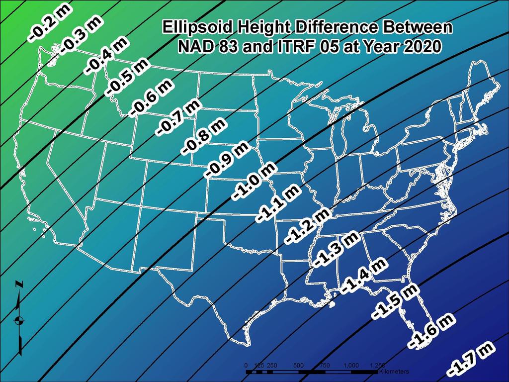
11 ELLIPSOID GEOID RELATIONSHIP H = Orthometric Height (NAVD 88) h = Ellipsoid Height (NAD 83 (2011)) N = Geoid Height (GEOID12A) H h H = h N Geoid Mean Sea Level Surface of NAVD 88 N Geoid Model Ellipsoid GRS80


12 GEOID 12A ACCURACY IN MARYLAND
 Established 1987 Office in Paris,")
13 Produces the International Terrestrial Reference System And International Terrestrial Reference Frame First ITRF 1988 Latest ITRF International Gold Standard International Earth Rotation and Reference System Service (IERS) Established 1987 Office in Paris, France


14 IERS Four Geodetic Services International GNSS Service International VLBI Service International Laser Ranging Service International DORIS Service

15 IERS NETWORK

16 Tectonic Plate Velocities IGS08 Velocities Towson, MD BACO N = m/yr E = m/yr U = m/yr
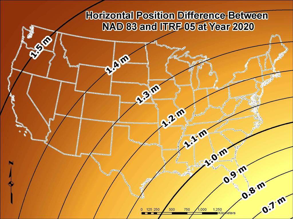
17 Simplified Concept of NAD 83 vs. ITRF/IGS h NAD83 h ITRF/IGS Earth s Surface ~ 1.5 m +/- 0.2 m CONUS ~ 1.4 m +/- 0.1 m AK ~ 1.9 m PR & VI ~ 2.5 m HI ~ 3.1 m AS ~ 2.3 m +/- 0.1 m GU & NM Baltimore Co. - BACO DX = m DY = m DZ = m 3D = m ITRF/IGS Origin NAD 83 Origin Identically shaped ellipsoids (GRS-80) a = 6,378, meters (semi-major axis) 1/f = (flattening)
18
19

20 Transition to the Future GRAV-D Gravity for the Redefinition of the American Vertical Datum Official NGS policy as of Nov 14, 2007 $38.5M over 10 years Airborne Gravity Snapshot Absolute Gravity Tracking Re-define the Vertical Datum of the USA by 2022 Approximately 34% Complete
")
 Launched 2009")
21 Space-Base Gravity Observations Gravity Recovery And Climate Experiment (GRACE) Launched Gravity field and steady state Ocean Circulation Explorer (GOCE) Launched 2009 Re-entered


 GRACE &")


 Surface")
22 Building a model of the Earths Gravity Field Long Wavelengths: ( 400 km) GRACE & GOCE Satellites + Airborne Measurement Intermediate Wavelengths (500 km to 20 km) + Short Wavelengths (< 200 km) Surface Measurement

23 Geopotential Datum Changes USGG2012
24 Why GRAV-D? A relatively small workforce can update the geoid as compared to the large workforce needed to re-level bench marks As the H=0 surface, the geoid will be tracked over time to keep the datum up to date A 2 cm target accuracy anywhere that GNSS receivers can be used, kept up to date through monitoring CORS and the geoid, is better than the accuracy and accessibility of NAVD 88 today It is far cheaper than leveling The geoid can t be bulldozed out of usefulness The effect of subsidence upon the realization will be known (and accounted for) by monitoring CORS and monitoring the geoid
25 NGS HAS CONCLUED: Tradition vertical datum observed by classical leveling w/passive marks Limited number of control points delivering mm precision Seldom where needed Continuously being disturbed or destroyed Can only be validated or replaced by repeat leveling programs Substantial personnel resources Outrageously expensive (Billion +) Or Why GRAV-D? A 2 cm target accuracy anywhere that GNSS receivers can be used Far cheaper than leveling Small support staff The geoid can t be bulldozed out of usefulness The effect of subsidence upon the realization will be known (and accounted for) by monitoring CORS and monitoring the geoid
26 How will I access the new vertical datum? Primary access (NGS mission) Users with geodetic quality GNSS receivers will continue to use OPUS suite of tools Ellipsoid heights computed, and then a gravimetric geoid applied to provide orthometric heights in the new datum. The datum is the geoid model in a data collector No passive marks needed
27 How will I access the new vertical datum? NAVD 88 conversion to new datum A conversion will be provided between NAVD 88 and the new datum Accurate and reliable only where recent GNSS ellipsoid heights exist to provide modern heights in the new datum
28 Predicated Positional Changes in 2022 near Denton, MD Computed for BYPASS (HU2580) HORIZONTAL = 1.13 m (3.7 ft) ELLIPSOID HEIGHT = m (- 4.3 ft) Computed with HTDP ORTHOMETRIC HEIGHT = m (- 1.2 ft) Computed with USGG2012 Can be easily computed from OPUS Extended Output 1: INVERSE NAD 83 (2011) and IGS08 Lat/Long 2: Subtract NAD 83 (2011) Eht from IGS08 Eht 3: Extended output gives estimated 2022 Orthometric Height
29 METADATA DATUMS and REALIZATIONS NAD 27, NAD 83(1986), NAD83 (199X), NAD 83 (2007), NAD 83 (2011), NGVD29, NAVD88 UNITS Meters, U.S. Survey Feet, International Feet ACCURACY A-Order, B-Order, 1 st, 2 nd, 3 rd, 3cm,.1 ft, Scaled etc. THE NUMBER OF DIGITS TO THE RIGHT OF THE DECIMAL POINT HAVE NOTHING TO DO WITH THE ACCURACY OF THE POSITON/HEIGHT
30 What can you do to get ready for 2022?? Understand the impact of changing positions and heights for your community, company or agency Watch for upcoming NGS status reports/webinars Consider legislative changes to Maryland Real Property Code, Title 14, Miscellaneous Rules, Subtitle 4 Should NGS continue to publish State Plane Coordinates? If yes: Retain or change NAD 83 geometric parameters? Communicate issues directly to NGS Joe Evjen joe.evjen@noaa.gov Geometric Datum Manager Mark Eckl mark.eckl@noaa.gov Geopotential Datum Manager
31 GOOD COORDINATION BEGINS WITH GOOD COORDINATES GEOGRAPHY WITHOUT GEODESY IS A FELONY
NGS is Scheduled to Replace NAVD 88 and NAD 83 In 2022
 NGS is Scheduled to Replace NAVD 88 and NAD 83 In 2022 Indiana Society of Professional Land Surveyors Conference January 2017 John Ellingson NGS Geodetic Advisor john.ellingson@noaa.gov 202-306-6904 1
The National Spatial Reference System of the Future
 The National Spatial Reference System of the Future William Stone Southwest Region (AZ, NM, NV, UT) Geodetic Advisor william.stone@noaa.gov NOAA s National Geodetic Survey geodesy.noaa.gov Salt Lake City
NATRF 2022 AND LDP OCTOBER 11, 2017
 NATRF 2022 AND LDP OCTOBER 11, 2017 MODERNIZATION OF THE NSRS Why? Leaving passive control marks behind and relying solely on the CORS network for 3D positions: Older methodology relies on terrestrial
Modernization of the National Spatial Reference System 2022 Datum. Jacksonville Chapter July 2018
 Modernization of the National Spatial Reference System 2022 Datum Jacksonville Chapter July 2018 Randy Tompkins, PSM, PLS Geomatics Project Manager Surveyor, Hydrographer, & Geodesist DRMP, Inc. Jacksonville,
MODERNIZATION OF THE NSRS
 NATRF 2022 AND LDP SEPTEMBER 12, 2017 MODERNIZATION OF THE NSRS Why? Leaving passive control marks behind and relying solely on the CORS network for 3D positions: Older methodology relies on terrestrial
BUILDING AN ACCURATE GIS
 BUILDING AN ACCURATE GIS 2006 GIS in the Rockies Denver, Colorado September 13, 2006 William E. Linzey United States Department of Commerce National Oceanic and Atmospheric Administration National Geodetic
U.S. Datums: Where We ve Been,
 U.S. Datums: Where We ve Been, Where We re Going Modernizing the National Spatial Reference System Matt Wellslager RFA, South Carolina Geodetic Survey Presentation Outline 1. - Introductions. 2. - National
Frames for the Future New Datum Definitions for Modernization of the U.S. National Spatial Reference System
 Figure 10. Horizontal position differences (in meters) between NAD 83 and ITRF 08 at time 2022.00 (January 1, 2022). Positional differences are shown for the North American and Pacific tectonic plates.
NGS and the Modernization of the National Spatial Reference System (NSRS)
") NGS and the Modernization of the National Spatial Reference System (NSRS) Dr. Dana Caccamise Pacific Southwest Region (CA,NV) Geodetic Advisor dana.caccamise@noaa.gov NOAA s National Geodetic Survey geodesy.noaa.gov
NGS and the Modernization of the National Spatial Reference System (NSRS) Dr. Dana Caccamise Pacific Southwest Region (CA,NV) Geodetic Advisor dana.caccamise@noaa.gov NOAA s National Geodetic Survey geodesy.noaa.gov
GISC3325 Spring 2011 Final Exam
 GISC3325 Spring 2011 Final Exam Name: Carefully read each question. Identify the important elements and the question being asked. Show your work for partial credit. No credit for undocumented wrong answers.
Session description and objectives
 Journey to the Moving Center of the Earth The Evolution of the National Spatial Reference System NJSPLS SurvCon 2018 January 31, 2018 Dan Martin Northeast Regional Geodetic Advisor ME, NH, VT, MA, CT,
The U.S. National Spatial Reference System in 2022
 Presented at the, May 29 - June 2, 2017 in The U.S. National Spatial Reference System in 2022 Daniel R. Roman, (Chief Geodesist) NOAA s National Geodetic Survey 1 Why change? Outline Naming conventions
Changes are coming NGS NSRS Modernization Are you Ready?
 Changes are coming NGS 2022 - NSRS Modernization Are you Ready? Pam Fromhertz Rocky Mountain Regional Advisor Pamela.Fromhertz@noaa.gov 240-988-6363 John Hunter CO State Geomatics Coordinator DRCOG March
New Datums: Replacing NAVD 88 and NAD 83
 New Datums: Replacing NAVD 88 and NAD 83 By Dave Zenk PE, LS National Geodetic Survey Northern Plains Regional Advisor 1735 Lake Drive West Chanhassen, MN 55317-8581 952-368-2548 office 612-414-9522 mobile
Positioning a nation for the future: Modernizing the United States National Spatial Reference System
 Positioning a nation for the future: Modernizing the United States National Spatial Reference System Dr. Dana Caccamise USA Representative Pacific Southwest Region Geodetic Advisor dana.caccamise@noaa.gov
4 Survey Datums. 4.1 Horizontal Datum Policy SURVEY DATUMS SEPTEMBER 2006
 4 Survey Datums Today s multi-organizational Project Development efforts require the use of common, accurate horizontal and vertical survey datums and consistent, precise control-survey procedures to ensure
Control Surveys and Coordinate Systems
 Control Surveys and Coordinate Systems The Earth is Round Basic Shape of the Earth: Oblate Spheroid of Revolution The length of the equatorial axis is approximately 27 miles greater than the polar axis.
Positioning the Pacific: NOAA s Geospatial Activities. Juliana Blackwell, Director NOAA s National Geodetic Survey March 6, 2012
 Positioning the Pacific: NOAA s Geospatial Activities Juliana Blackwell, Director NOAA s National Geodetic Survey March 6, 2012 A Common Problem of the Early 19 th Century 1807 President Thomas Jefferson
Vertical Reference Frame Pacific
 Vertical Reference Frame Pacific Andrick Lal SPC Geoscience Division GIS&RS User Conference 29 th November 2016 USP, Fiji. What does it mean? All buildings and features have a height. But what is it relative
Height Modernization 2013 A New Canadian Vertical Datum
 Height Modernization 2013 A New Canadian Vertical Datum What is Height Modernization? The Height Reference System Modernization is a project at the Geodetic Survey Division (GSD) of Natural Resources Canada
GRAV-D. Gravity for the Re-definition of the American Vertical Datum
 GRAV-D Gravity for the Re-definition of the American Vertical Datum Why this briefing? NGS recently acquired a new airborne gravimeter Intended to support GRAV-D GRAV-D is an ambitious new plan for NGS
Modernization of National Geodetic Datum in China *
 UNITED NATIONS E/CONF.102/IP.16 ECONOMIC AND SOCIAL COUNCIL Nineteenth United Nations Regional Cartographic Conference for Asia and the Pacific Bangkok, 29 October 1 November 2012 Item 6(b) of the provisional
Beyond GEOID12: Implementing a New Vertical Datum for North America
 Daniel R. ROMAN, Neil D. WESTON, UNITED STATES Key words: Positioning, Heights, GPS/Leveling, Geoid, Vertical Datum SUMMARY The National Geodetic Survey (NGS) is responsible for maintaining both the horizontal
Achieving Great Height with GNSS
 Achieving Great Height with GNSS Oregon GPS Users Group 2015 Annual Meeting January 23, 2015 Salem, Oregon Salem Convention Center Michael Dennis, RLS, PE Oregon State University National Geodetic Survey
Height Modernization Program in the United States: Implementing a Vertical Datum Referenced to a Gravimetric Geoid Model
 Height Modernization Program in the United States: Implementing a Vertical Datum Referenced to a Gravimetric Geoid Renee Shields, Christine Gallagher, USA Key words: GNSS, orthometric height, elevation,
Making Sense of Evolving Reference Frames for North America
 Making Sense of Evolving Reference Frames for North America Mike Craymer Geodetic Survey Division, Natural Resources Canada Giovanni Sella U.S. National Geodesy Survey American Geophysical Union 2007 Joint
New Datums: Replacing NAVD 88 and NAD 83
 New Datums: Replacing NAVD 88 and NAD 83 Professional Surveyors Association of Nebraska Winter Seminar Dave Zenk NGS Advisor February 9, 2018 Kearney, NE February 9, 2018 Professional Surveyors Association
Fusion of Geodesy and GIS at NOAA s National Geodetic Survey
 Fusion of Geodesy and GIS at NOAA s National Geodetic Survey Esri Survey Summit July 6-9, 2013 San Diego, CA Michael Dennis, RLS, PE michael.dennis@noaa.gov The Plan Background NGS Data Explorer New Datasheet
From Global to National Geodetic Reference Frames: how are they connected and why are they needed?
 From Global to National Geodetic Reference Frames: how are they connected and why are they needed? Zuheir ALTAMIMI Institut National de l Information Géographique et Forestière, France Vice-President,
VT State Plane. Daniel J. Martin National Geodetic Survey VT Geodetic Advisor. VSLS Conference Rutland VT April 11, 2008
 VT State Plane Daniel J. Martin National Geodetic Survey VT Geodetic Advisor VSLS Conference Rutland VT April 11, 2008 Today s Outline Define the problem Review of VT State Plane System Relationship
The Global Geodetic Observing System (GGOS) of the International Association of Geodesy (IAG)
 of the International Association of Geodesy (IAG)") The Global Geodetic Observing System (GGOS) of the International Association of Geodesy (IAG) Hermann Drewes Representative of the International Union of Geodesy and Geophysics (IUGG) to the Cartographic
The Global Geodetic Observing System (GGOS) of the International Association of Geodesy (IAG) Hermann Drewes Representative of the International Union of Geodesy and Geophysics (IUGG) to the Cartographic
TOWARDS ROBUST LOCALIZATION OF RTK-GPS TOPOGRAPHIC SURVEYS 23
 TOWARDS ROBUST LOCALIZATION OF RTK-GPS TOPOGRAPHIC SURVEYS Jerry W. Nave, North Carolina A&T University; Tarig A. Ali, American University of Sharjah Abstract Localization is performed to fit the observed
GEODETIC NETWORK OF SAUDI ARABIA AND FIDUCIAL STATIONS. GFN OF Saudi Arabia in Based on ITRF2000 Datum
 STUDIES OF TECTONIC MOVEMENTS IN SAUDI ARABIA USING CORS M. Al Rajhi, Ali Al Omar, R. Yanar, F. Kartal, K. Eren, SUBJECT TO TALKS BACKGROUND GEODETIC NETWORK OF SAUDI ARABIA AND FIDUCIAL STATIONS GFN OF
The U.S. National Spatial Reference System in 2022
 The U.S. National Spatial Reference System in 2022 Daniel ROMAN, U.S.A. Key words: Capacity Building; GNSS/GPS; Legislation; Positioning; Reference Frames; Reference Systems; Standards SUMMARY In 2022,
The Future of SPCS in Charles Chuck Ghilani, Ph.D. Professor Emeritus Pennsylvania State University
 The Future of SPCS in 2022 Charles Chuck Ghilani, Ph.D. Professor Emeritus Pennsylvania State University Class Etiquette Turn off all cell phones Or set them to vibrate Go out of the room to answer any
GPS Derived Heights: A Height Modernization Primer
 GPS Derived Heights: A Height Modernization Primer October 25, 2007 National Geodetic Survey Indiana Height Modernization Forum Renee Shields National Geodetic Survey National Oceanic and Atmospheric Administration
New satellite mission for improving the Terrestrial Reference Frame: means and impacts
 Fourth Swarm science meeting and geodetic missions workshop ESA, 20-24 March 2017, Banff, Alberta, Canada New satellite mission for improving the Terrestrial Reference Frame: means and impacts Richard
HORIZONTAL PROJECTION PARAMETERS: DANE COUNTY COORDINATES
 Recommended RTK GPS Configuration Parameters for the City of Madison, WI Base Station Compiled by: Dan Rodman RLS, City of Madison (608)266-6674 drodman@cityofmadison.com For base station information see
A Unique Reference Frame: Basis of the Global Geodetic Observing System (GGOS) for Geodynamics and Global Change
 for Geodynamics and Global Change") SRTM (InSAR) A Unique Reference Frame: Basis of the Global Geodetic Observing System (GGOS) for Geodynamics and Global Change Hermann Drewes President IAG Commission 1 Reference Frames Deutsches Geodätisches
SRTM (InSAR) A Unique Reference Frame: Basis of the Global Geodetic Observing System (GGOS) for Geodynamics and Global Change Hermann Drewes President IAG Commission 1 Reference Frames Deutsches Geodätisches
The 3-D Global Spatial Data Model: Geometrical Foundation of the Global Spatial Data Infrastructure
 The 3-D Global Spatial Data Model: Geometrical Foundation of the Global Spatial Data Infrastructure Earl F. Burkholder, PS, PE Annotated Table of Contents July 8,2006 I. The Global Spatial Data Model (GSDM)
GEOID UNDULATIONS OF SUDAN USING ORTHOMETRIC HEIGHTS COMPARED WITH THE EGM96 ANG EGM2008
 GEOID UNDULATIONS OF SUDAN USING ORTHOMETRIC HEIGHTS COMPARED Dr. Abdelrahim Elgizouli Mohamed Ahmed* WITH THE EGM96 ANG EGM2008 Abstract: Positioning by satellite system determine the normal height above
A Strategic Plan for Geodesy in Sweden. Mikael Lilje Lars E. Engberg Geodesy Department Lantmäteriet Sweden
 A Strategic Plan for Geodesy in Sweden Mikael Lilje Lars E. Engberg Geodesy Department Lantmäteriet Sweden Our vision is to be able to meet Swedish society s needs for a homogeneous, sustainable geodetic
Inclusion of Leveling with GNSS Observations in a Single, 3-D Geodetic Survey Network Adjustment. Daniel GILLINS, U.S.A., and Michael DENNIS, U.S.A.
 Inclusion of Leveling with GNSS Observations in a Single, 3-D Geodetic Survey Network Adjustment Daniel GILLINS, U.S.A., and Michael DENNIS, U.S.A. Key words: Leveling, Integrated Geodesy, Geoid Accuracy,
Next Generation Australian Datum. Permanent Committee on Geodesy, ICSM
 Next Generation Australian Datum Permanent Committee on Geodesy, ICSM 2 Presentation: Next Generation Australian Datum Trends in the geospatial sector The Geocentric Datum of Australia 1994 (GDA94) Progress
GGOS Bureau for Standards and Conventions
 GGOS D. Angermann (1), T. Gruber (2), J. Bouman (1), M. Gerstl (1), R. Heinkelmann (1), U. Hugentobler (2), L. Sánchez (1), P. Steigenberger (2) (1) Deutsches Geodätisches Forschungsinstitut (DGFI), München
Update on the International Terrestrial Reference Frame (ITRF) : ITRF2014. Zuheir Altamimi
 : ITRF2014. Zuheir Altamimi") Update on the International Terrestrial Reference Frame (ITRF) : ITRF2014 Zuheir Altamimi Head of the IERS ITRF Product Center IAG Vice President IGN, France E-mail: zuheir.altamimi@ign.fr Key Points Introduction:
Update on the International Terrestrial Reference Frame (ITRF) : ITRF2014 Zuheir Altamimi Head of the IERS ITRF Product Center IAG Vice President IGN, France E-mail: zuheir.altamimi@ign.fr Key Points Introduction:
Geographic Information Systems class # 1 February 19, Coordinate reference systems in GIS: geodetic coordinates
 Geographic Information Systems class # 1 February 19, 2013 Coordinate reference systems in GIS: geodetic coordinates Manuel Campagnolo ISA Manuel Campagnolo (ISA) GIS/SIG 2012 2013 February 19, 2013 1
Global & National Geodesy, GNSS Surveying & CORS Infrastructure
 Global & National Geodesy, GNSS Surveying & CORS Infrastructure Chris Rizos School of Surveying & Spatial Information Systems University of New South Wales, Sydney, Australia President-elect, International
Town of Chino Valley. Survey Control Network Report. mgfneerhg mc N. Willow Creek Road Prescott AZ
 Town of Chino Valley Survey Control Network Report mgfneerhg mc. 2050 N. Willow Creek Road Prescott AZ 86301 928-771-2376 Page 1 of 70 Table of Contents Town of Chino Valley Survey Datum Outline A short
Geog Lecture 29 Mapping and GIS Continued
 Geog 1000 - Lecture 29 Mapping and GIS Continued http://scholar.ulethbridge.ca/chasmer/classes/ Today s Lecture (Pgs 13-25, 28-29) 1. Hand back Assignment 3 2. Review of Dr. Peddle s lecture last week
System of Geodetic Parameters Parametry Zemli 1990 PZ-90.11
 System of Geodetic Parameters Parametry Zemli 1990 PZ-90.11 Authors: PhD Anastasiya N. Zueva, PhD Evgeniy V. Novikov, Dr. Dmitriy I. Pleshakov, PhD Igor V. Gusev Speaker: Igor Gusev 9 th Mee'ng of the
National Geodetic Survey
 Geodesy, Geoids, and Vertical Datums: A Perspective from te U.S. ational Geodetic Survey Daniel R. ROMA, Yan Ming WAG, Jarir SALEH, and Xiaopeng LI Paper 3768 ational Geodetic Survey An Office wit te ational
Geodetic Observing Systems: tools in observing the Glacial Isostatic Adjustment. Markku Poutanen Finnish Geodetic Institute
 Geodetic Observing Systems: tools in observing the Glacial Isostatic Adjustment Markku Poutanen Finnish Geodetic Institute Glacial Isostatic Adjustment Land uplift is just one consequence of the physical
Reference Systems. Paolo Zatelli - Alfonso Vitti. Dept. Civil and Environmental Engineering University of Trento
 Reference Systems Reference Systems Paolo Zatelli - Alfonso Vitti Dept. Civil and Environmental Engineering University of Trento P. Zatelli - A. Vitti University of Trento - Italy 1 / 34 Reference Systems
Update on GRAV-D and Progress toward a new vertical Datum
 Update on GRAV-D and Progress toward a new vertical Datum New York Association of Professional Land Surveyors January 17, 201 Dan Martin Northeast Regional Geodetic Advisor ME, NH, VT, MA, CT, RI, NY,
Height systems. Rudi Gens Alaska Satellite Facility
 Rudi Gens Alaska Satellite Facility Outline Why bother about height systems? Relevant terms Coordinate systems Reference surfaces Geopotential number 2 Why bother about height systems? give a meaning to
Report for 15th PCGIAP Meeting at 18th UNRCC-AP Working Group 1 Regional Geodesy
 Report for 15th PCGIAP Meeting at 18th UNRCC-AP Working Group 1 Regional Geodesy Chairman Shigeru Matsuzaka, Japan - shigeru@gsi.go.jp Vice Chairman Prof. Pengfei Cheng, China - chengpf@casm.ac.cn John
Spatial Data Collection using GPS: BEST PRACTICES
 Spatial Data Collection using GPS: BEST PRACTICES - 2007 Page 1 of 10 Best practices for GPS & Spatial Data Collection, Storage and Documentation These Best Practices are designed to maximize positional
Consideration of a Global Vertical Reference System (GVRS) in the IERS Conventions
 in the IERS Conventions") Consideration of a Global Vertical Reference System (GVRS) in the IERS Conventions Johannes Ihde Federal Agency for Cartography and Geodesy (BKG) Chair of IAG ICP1.2 (2003-2007) Vertical Reference Frames
Consideration of a Global Vertical Reference System (GVRS) in the IERS Conventions Johannes Ihde Federal Agency for Cartography and Geodesy (BKG) Chair of IAG ICP1.2 (2003-2007) Vertical Reference Frames
The Global Geodetic Observing System (GGOS) of the International Association of Geodesy, IAG
 of the International Association of Geodesy, IAG") The Global Geodetic Observing System (GGOS) of the International Association of Geodesy, IAG Hans-Peter Plag (1), Markus Rothacher (2), Richard Gross (3), Srinivas Bettadpur (4) (1) Nevada Bureau of Mines
The Global Geodetic Observing System (GGOS) of the International Association of Geodesy, IAG Hans-Peter Plag (1), Markus Rothacher (2), Richard Gross (3), Srinivas Bettadpur (4) (1) Nevada Bureau of Mines
Case Study of Australia
 Case Study of Australia John Dawson, Geoscience Australia 1 Australia s Geodetic eco-system Geocentric Coordinates Observing Infrastructure Height Datum Geoid Models Tools Services Standards 2 Australia
The Future of SPCS in 2022
 The Future of SPCS in 2022 Charles Chuck Ghilani, Ph.D. Professor Emeritus Pennsylvania State University Class Etiquette Turn off all cell phones Or set them to vibrate Go out of the room to answer any
Meeting the ODOT Survey & Mapping Specifications
 Meeting the ODOT Survey & Mapping Specifications A Simple Solution Presented by Ray Foos, P.S, ODOT CADD & Mapping Services & Jon Keller, P.S., ODOT District 3 Phases of an ODOT Survey Project Research
ELECTRONICS DIVISION INTERNAL REPORT NO. 324
 NATIONAL RADIO ASTRONOMY OBSERVATORY Green Bank, West Virginia ELECTRONICS DIVISION INTERNAL REPORT NO. 324 NRAO 43m Antenna Coordinates and Angular Limits (Version 4) Glen Langston September 14, 2012
United States NSRS 2022: Terrestrial Reference Frames
 United States NSRS 2022: Terrestrial Reference Frames Daniel ROMAN, U.S.A. Key words: Capacity building; Positioning; Reference frames; Reference systems, Cadastre SUMMARY In 2022, the United States will
Dependences in the pillar Earth s gravity field of
 Reports on Geodesy, vol. 92, no. 1, 2012 Dependences in the pillar Earth s gravity field of GGOS - description using UML notation Małgorzata Paśnicka 1, Karolina Szafranek 2, Agnieszka Zwirowicz Rutkowska
Geodesy on the move. Craig Allinson. Dealing with dynamic coordinate reference systems. IOGP Geodesy Subcommittee. EPUG London, November 2017
 Geodesy on the move Dealing with dynamic coordinate reference systems Craig Allinson IOGP Geodesy Subcommittee EPUG London, November 2017 Why the concern? A bridge too far Historic geodesy mental image
Contributions of Geodesy to Oceanography
 Contributions of Geodesy to Oceanography B. Tapley and J. Ries Center for Space Research, The University of Texas at Austin Dynamic Planet 2005 Cairns, Australia August 22-26, 2005 August 22-26, 2005 Dynam
Geodesy, Geoids, and Vertical Datums: A Perspective from the U.S. National Geodetic Survey
 Geodesy, Geoids, and Vertical Datums: A Perspective from the U.S. National Geodetic Survey, UNITED STATES Key words: Positioning, Heights, GPS/Leveling, Remote Sensing, Coastal Zone Management SUMMARY
Case study of Japan: Reference Frames in Practice
 Case study of Japan: Reference Frames in Practice Basara Miyahara and Koji Matsuo Sponsors: 1 Outline Introduction - Geodetic reference frame of Japan - GEONET : continuous GNSS observation system Geometric
Lecture 2 Measurement Systems. GEOS 655 Tectonic Geodesy
 Lecture 2 Measurement Systems GEOS 655 Tectonic Geodesy VLBI and SLR VLBI Very Long Baseline Interferometry SLR Satellite Laser Ranging Very Long Baseline Interferometry VLBI Geometric Delay δg S Baseline
The International Terrestrial Reference System and ETRS89: Part II : ITRS & ETRS89 relationship
 The International Terrestrial Reference System and ETRS89: Part II : ITRS & ETRS89 relationship Zuheir ALTAMIMI Laboratoire de Recherche en Géodésie Institut national de l information géographique et forestière
Spatial Reference Systems. Introduction
 Spatial Reference Systems Wolfgang Kainz Professor of Cartography and Geoinformation Department of Geography and Regional Research University of Vienna wolfgang.kainz@univie.ac.at Introduction Historic
The Canadian Height Modernization Initiative. Information for British Columbia Stakeholders / Clients
 The Canadian Height Modernization Initiative Information for British Columbia Stakeholders / Clients Introduction A modern society requires the ability to measure elevations relative to mean sea level
Shape of the Earth. Data Output by the Receiver
 It is quite common for confusion to arise about the process used during a hydrographic survey when GPS-derived water surface elevation is incorporated into the data as an RTK Tide correction. This article
Boolean Operators and Topological OVERLAY FUNCTIONS IN GIS
 Boolean Operators and Topological OVERLAY FUNCTIONS IN GIS Query asking a question of the attribute data Standard Query Language (SQL) is used to query the data There are 4 basic statements used to get
Analytical and Computer Cartography Lecture 3: Review: Coordinate Systems
 Analytical and Computer Cartography Lecture 3: Review: Coordinate Systems Geographic Coordinates NAD83 NAD27 remained in use until the earthcentered international GRS80 was complete (Geodetic Reference
GRAVITY SURVEY TEELS MARSH PROSPECT
 GRAVITY SURVEY over the TEELS MARSH PROSPECT MINERAL COUNTY, NV for Dajin Resources (US) Corp. March 2015 SUBMITTED BY Magee Geophysical Services LLC 465 Leventina Canyon Road Reno, Nevada 89523 USA TEL
Modern Navigation. Thomas Herring
 12.215 Modern Navigation Thomas Herring Today s Class Latitude and Longitude Simple spherical definitions Geodetic definition: For an ellipsoid Astronomical definition: Based on direction of gravity Relationships
GEOGRAPHIC COORDINATE SYSTEMS
 GEOGRAPHIC COORDINATE SYSTEMS Introduction to GIS Winter 2015 What is Georeferencing? Used to establish a location on the Earth s surface 1 st order polynomial transformation Georeferencing toolbar What
Using UNAVCO Real-Time CORS Data, a No-Cost Positioning Resource
 Using UNAVCO Real-Time CORS Data, a No-Cost Positioning Resource By: Mark Silver, ms@igage.com, +1-801-412-0011 Date: 19 August 2014 UNAVCO is a non-profit consortium of Universities that coordinates the
A new geoid model for Bhutan. Machiel Bos Rui Fernandes
 A new geoid model for Bhutan Machiel Bos (machiel@segal.ubi.pt) Rui Fernandes (rui@segal.ubi.pt) June 2015 1 Definition of heights June 2015 2 Purpose of a geoid model Orthometric heights are the official
Intro to GIS Fall 2010 Georeferencing & Map Projections
 Intro to GIS Fall 2010 Georeferencing & Map Projections SHAPE OF THE EARTH Earth's Shape Geoid: shape of earth minus topographic features (irregular due to local variations in gravity) Ellipsoid: elongated
Ellipsoid Hydro Datum Geoid Errors
 Ellipsoid Hydro Datum Geoid Errors Jack L. Riley Office of Coast Survey Hydrographic Systems & Technology Branch Geoid Errors via Ellipsoid Hydrography? Per datum hydro Traditional & ellipsoid referenced
How significant is the dynamic component of the North American vertical datum?
 CGU Annual Scientific Meeting -8 June 212, Banff, Canada How significant is the dynamic component of the North American vertical datum? E. Rangelova, M.G. Sideris (University of Calgary) W. van der Wal
Country Report on SDI Activities in Singapore *
 UNITED NATIONS E/CONF.100/CRP.9 ECONOMIC AND SOCIAL COUNCIL Eighteenth United Nations Regional Cartographic Conference for Asia and the Pacific Bangkok, 26-29 October 2009 Item 7(a) of the provisional
PGM2016: A new geoid model for the. Philippines
 PGM2016: A new geoid model for the Philippines United Nations/Nepal Workshop on the Applications of Global Navigation Satellite Systems Kathmandu, Nepal December 12-16, 2016 Ronaldo Gatchalian, Chief Geodesy
GPS and Mean Sea Level in ESRI ArcPad
 Summary In order to record elevation values as accurately as possible with, it is necessary to understand how ArcPad records elevation. Rather than storing elevation values relative to Mean Sea Level (MSL),
Publ. Astron. Obs. Belgrade No. 91 (2012), REALIZATION OF ETRF2000 AS A NEW TERRESTRIAL REFERENCE FRAME IN REPUBLIC OF SERBIA
, REALIZATION OF ETRF2000 AS A NEW TERRESTRIAL REFERENCE FRAME IN REPUBLIC OF SERBIA") Publ. Astron. Obs. Belgrade No. 91 (2012), 199-206 Contributed paper REALIZATION OF ETRF2000 AS A NEW TERRESTRIAL REFERENCE FRAME IN REPUBLIC OF SERBIA D. BLAGOJEVIĆ and V. VASILIĆ Faculty of Civil Engineering,
Publ. Astron. Obs. Belgrade No. 91 (2012), 199-206 Contributed paper REALIZATION OF ETRF2000 AS A NEW TERRESTRIAL REFERENCE FRAME IN REPUBLIC OF SERBIA D. BLAGOJEVIĆ and V. VASILIĆ Faculty of Civil Engineering,
What are the social, technical, environmental and economic benefits and opportunities of accessing and sharing geodetic data?
 What are the social, technical, environmental and economic benefits and opportunities of accessing and sharing geodetic data? Graeme Blick Group Manager Positioning and Resilience Land Information New
Global vertical datum unification based on the combination of the fixed gravimetric and the scalar free geodetic boundary value problems
 Global vertical datum unification based on the combination of the fixed gravimetric and the scalar free geodetic boundary value problems Laura Sánchez contribution to the IAG-IC.: Vertical Reference Frames
How GNSS CORS in Japan works for geodetic control and disaster mitigations
 ICG Working Group D Reference Frames, Timing and Applications How GNSS CORS in Japan works for geodetic control and disaster mitigations ICG11, Nov. 7-11, 2016, Sochi, Russia Hiromichi TSUJI Geodetic Observation
Lecture 4. Coordinate Systems & Projections
 Lecture 4 Coordinate Systems & Projections Outline Geodesy Geoids Ellipsoids Geographic Coordinate Systems Magnetic North vs. True North Datums Projections Applying Coordinate Systems and Projections Why
Geodetic applications of GNSS in the Black Sea region
 BALGEOS II - Balkan countries integration into GGOS Second workshop, 27-29 January, 2010 Vienna - AUSTRIA Geodetic applications of GNSS in the Black Sea region Lyubka Pashova CENTRAL LABORATORY OF GEODESY
Mobile Mapping Tips and Tricks
 Mobile Mapping Tips and Tricks Projections, Datums and Geoids, May 2017 Introduction This guide is designed to provide a basic understanding of coordinate system projections, datums and geoids. The guide
KEYSTONE PROPERTY GRAVITY GIS DATABASE. Residual Gravity Looking Down to Northwest
 KEYSTONE PROPERTY GRAVITY - 2018 GIS DATABASE Residual Gravity Looking Down to Northwest James L. Wright M.Sc. May 11, 2018 TABLE OF CONTENTS INTRODUCTION......................... 2 SURVEY PROCEDURE......................
GGOS, ECGN and NGOS: Global and regional geodetic observing systems. Markku Poutanen Finish Geodetic Institute
 GGOS, ECGN and NGOS: Global and regional geodetic observing systems Markku Poutanen Finish Geodetic Institute Contents GGOS, ECGN, NGOS Why? How? Future? (geodesy) GGOS Structure GGOS Structure European
What s Up? Tidal and Vertical Datums. Noel Zinn Hydrometronics LLC July 2011, revised November 2013
 What s Up? Tidal and Vertical Datums Noel Zinn Hydrometronics LLC www.hydrometronics.com July 2011, revised November 2013 1 Motivation The real world is three-dimensional, therefore, coordinates are necessarily
GGOS INFORMATION MODELS: ANALYSIS OF INTERRELATIONS BETWEEN OBSERVATION TECHNIQUES AND THE EARTH GRAVITY FIELD
 GGOS INFORMATION MODELS: ANALYSIS OF INTERRELATIONS BETWEEN OBSERVATION TECHNIQUES AND THE EARTH GRAVITY FIELD Wojciech Pachelski 1) Małgorzata Paśnicka-Pawłowska 2) Karolina Szafranek 3) Agnieszka Zwirowicz
Establishment of a Global Absolute Gravity Network
 Establishment of a Global Absolute Gravity Network H. Wilmes 1), H. Wziontek 1), R. Falk 1), J. Ihde 1), S. Bonvalot 2), R. Forsberg 3), S. Kenyon 4), L. Vitushkin 5) 1) Federal Agency for Cartography