Analytical and Computer Cartography Lecture 3: Review: Coordinate Systems
|
|
|
- Oliver Higgins
- 5 years ago
- Views:
Transcription

1 Analytical and Computer Cartography Lecture 3: Review: Coordinate Systems
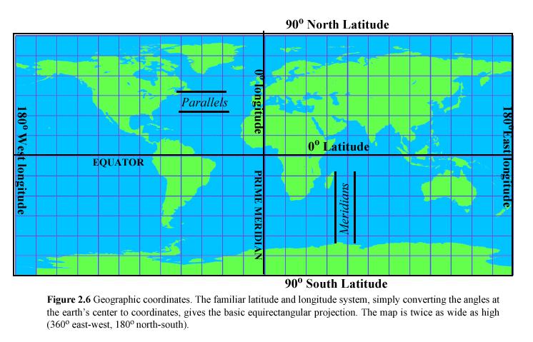
2 Geographic Coordinates
3 NAD83 NAD27 remained in use until the earthcentered international GRS80 was complete (Geodetic Reference System 1980) Then converted to NAD83, using GRS80 ellipsoid Very similar ellipsoid WGS84 was adopted by DOD and many other mapping agencies Meades ranch now just a historical relic
4 IERS Provides data on Earth orientation, on the International Celestial Reference System/Frame, on the International Terrestrial Reference System/Frame, and on geophysical fluids Maintains Conventions containing models, constants and standards Includes ITRS
5 IERS
6 NAD2022 and NAVD2022 North American Datum of 1983 will be replaced by a new geometric datum which provides latitude, longitude, height and time information. Will rely completely on the CORS network (continuously operating reference stations) NGS is completing a major project called Gravity for the Redefinition of the American Vertical Datum, or GRAV-D. The scale of the change will vary depending on your location, ranging from 0.5 to 1.5 meters in a horizontal direction, and 0 to 1.3 meters in elevation. Many state and other governmental entities passed laws on NAD83 that will need to be changed to reflect the new datum Will create the National Spatial Reference System
7 Resources nline_lessons/ cription/ngs_video_library.shtml

8 NAD83 to NAD2022
9 Datums and Map Projections Assuming an earth model sets the initial surface that will be transformed Influences both position and height If projection does not document the datum, it may be irreversible Most GIS packages create metadata files that establish key parameters After NAD2022, time will be an integral part of position
10 Ways to Record Lat/Long Decimal Degrees DMS Hemisphere First Decimal Minutes Decimal Seconds N W N385359W o N 77 o W 38 o N 77 o W
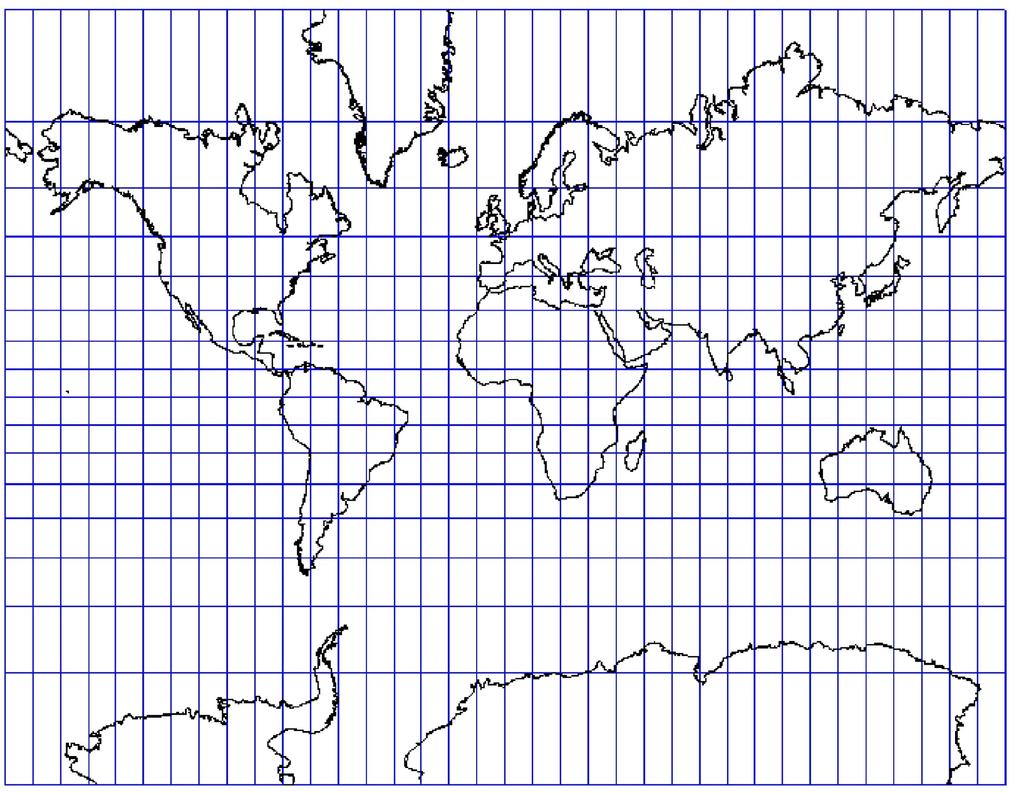
11 Problems with Geographic Coordinates Spherical geometry difficult, need great circle arcs for many applications Precision depends on mixed DMS and DD origin maps Axes are not orthogonal Difficult to use algorithms for spherical measurements e.g. simple distance in x =cos(φ) Solution: Planar geometry But, price is living with an imperfect projection
12 USGS Topographic maps Seven and a half minutes of longitude wide Seven and a half minutes of latitude high So why aren t they square? 7 ½ 7 ½

13 Lets check two locations Flag Island, Minnesota at 49 o 22 N Card Sound, Florida at 25 o 22'N


14 Card Sound, Florida at 25 o 22'N. Flag Island, Minnesota at 49 o 22N.
15 Using Projections Choice of projection allows control over map center, plus pattern of distortion Can optimize projection for map purpose, e.g. choose standard parallels Allows customizations for particular maps and applications, e.g. navigation Often chosen once then choice remains in place E.g. Mercator for navigation by compass
: Note")
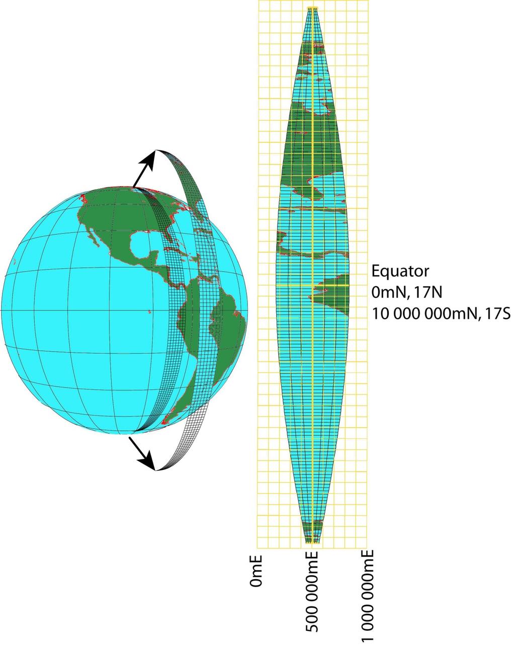
16 Great circles are straight on some conformal projections (Gnomic): Note crossing angles

17 JFK to LHR: Approximating a great circle on the Mercator. Only 41km farther (0.74%)
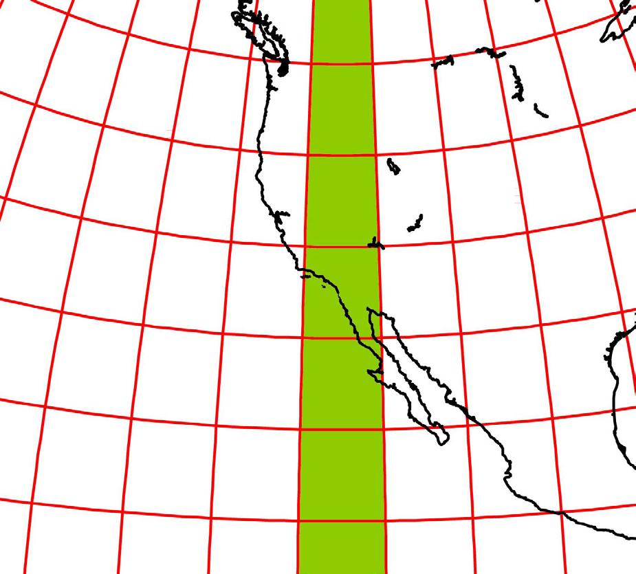
18 Projection and Coordinate Systems A coordinate system is a standardized method for assigning codes to locations so that locations can be found using the codes alone Standardized coordinate systems use absolute locations In a coordinate system, the x-direction value is the easting and the y-direction value is the northing Most systems make both values positive Can use letters, numbers Can interweave digits for x and y

19 What3words: 3 x 3m squares
20 Coordinate Systems for the US Some standard coordinate systems used in the United States are geographic coordinates universal transverse Mercator system military grid/mgrs/national grid state plane To compare or edge-match, both maps MUST be in the same coordinate system.
21 Equatorial Mercator
22 Transverse Mercator

23 The advantage of the transverse Mercator projection
24 UTM Universal transverse Mercator coordinate system Basis for 3 grid systems: Civilian UTM, MGRS and US National Grid Used in Hybrid form by geohack Uses 60 projections with 6 degrees between central meridians

25 Applies 80 o S to 84 0 N

26 60 zones each 6o of longitude wide
27 UTM Zones One degree = 111,111m Six degrees = 666,666 Set Zone false origin so that central meridian is 500,000m Gives 166,666m of overlap on each side at equator Overlap ends at about 25 o N/S

28 Zones overlap slightly when 1million meters wide
29 Zone 11N
30
31 Grid north and the Zone

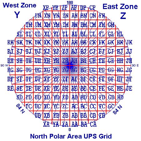
32 Universal Polar Stereographic (UPS)

33 Example, GPS fix E; N 11, N


34 Geohack Isla Vista
35 UTM zones in the USA

36 Military Grid Coordinates First Reference (6 x 8 degrees)
37 USMG: 2 nd Reference 100,000m cells

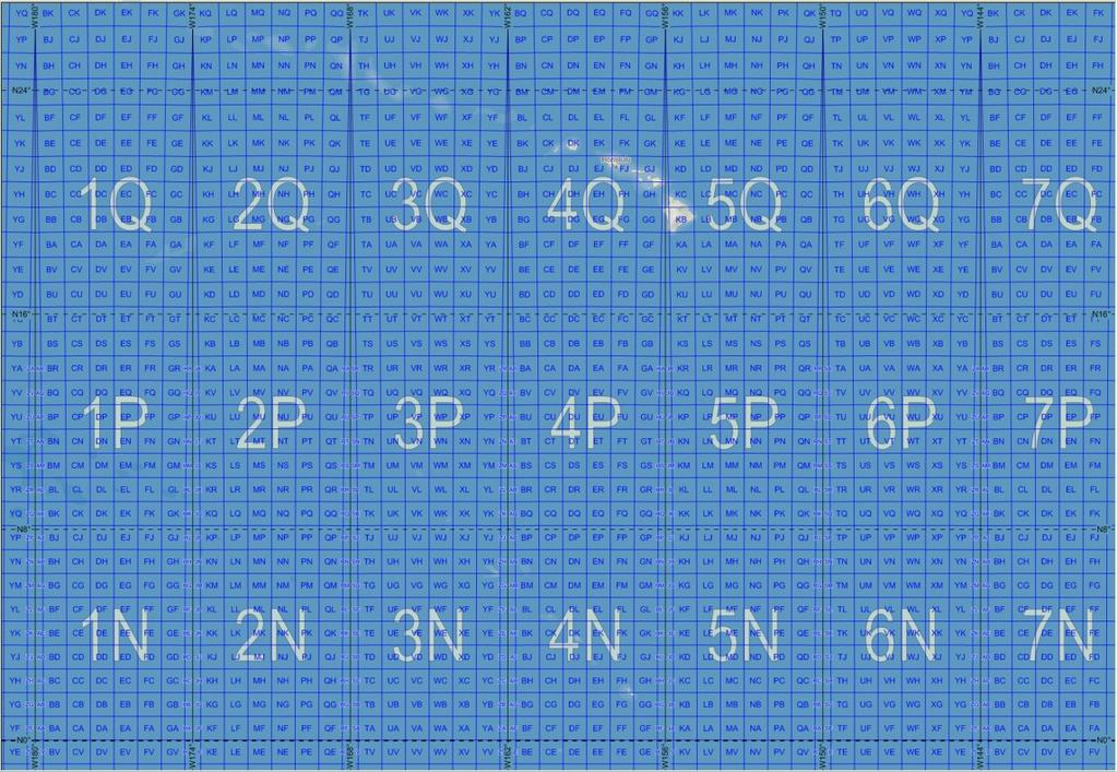
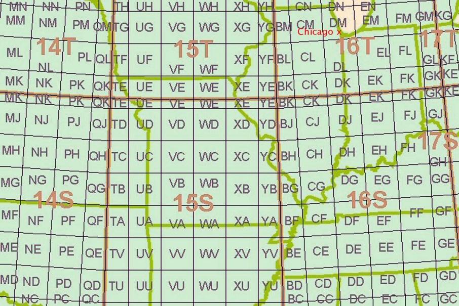
38 MGRS Grid Cell Designators
39 MGRS/National Grid
 4QFJ.")

40 Anatomy of a MGRS coordinate 4Q...GZD only, precision level 6 8 (in most cases) 4QFJ...GZD and 100 km SQ_ID, precision level 100 km 4QFJ16...precision level 10 km 4QFJ precision level 1 km 4QFJ precision level 100 m 4QFJ precision level 10 m 4QFJ precision level 1 m

41 USNG: The National Grid Same as the MGRS except uses NAD83 Maximum difference only c 2m worldwide Supported in National Map Some problems at cell boundaries

42 State Plane Coordinates

43 Zones: Lambert Conformal Conic vs. Transverse Mercator (Plus one Hotine Oblique Mercator)
44

45 Measurement: Just use GPS 6 decimal places o x m =0.11m
46 Converting
47

48 Coordinate examples 238,479 me; 3,811,950 mn; 11, N 11SKU SKU NAD83 N 34 o W 119 o CA 5
49 Code Libraries Matthew's Map Projection Software mps/ PROJ.4 GEOTRANS Java Map projection Library
")
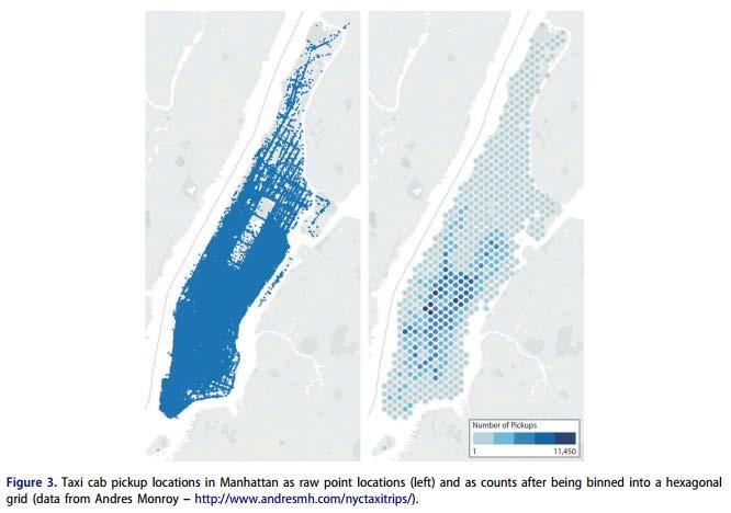
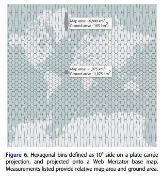
50 Sarah E. Battersby, Daniel daan Strebe & Michael P. Finn (2016) Shapes on a plane: evaluating the impact of projection distortion on spatial binning, Cartography and Geographic Information Science, Issue: Much social data is binned by lat/long grid cells, not taking into account projection distortion Suggest ways that cells can be equalized: using hexagons and binning by equal areas
51 Fits distortion analysis tradition
52 Degree of digit variation in a line 4QFJ QFJ QFJ QFJ QFJ QFJ Red values do not change Green values are 2 of 10 possible values Blue digits are 2 of 10 possible values Purple digits are 5 of 10 possible values
53 Suspicious 4QFJ QFJ QFJ QFJ QFJ QFJ Always 0 or 5, rounded? But only in the Easting
54 Information content For any digit n at any one significant digit location out of N possible digit values or states (10 for decimal), I is defined, where: First digit of the coordinates are all 4 so nine digits would have no occurrence ( x 9 = -0.9) and one digit would occur alone ( = 0.9), which sums to 1.8. If all values are equally represented, I = 0.0

55 The Coordinate Digit Density Function
56 Summary Geographic Reference System allows positions to be described Geographic coordinates are not planar Euclidean coordinates need a plane, and orthogonal axes Many standard coordinate systems are in use e.g. State Plane, UTM, MGRS, National Grid We can compute information content for sets of coordinates Coordinate digits can be redundant to random To merge and overlap maps, they must be in the same map projection, datum and coordinate system
Lesson 5: Map Scale and Projections
 Organizing Data and Information Lesson 5: Map Scale and Projections Map Scales Projections Information can be organized as lists, numbers, tables, text, pictures, maps, or indexes. Clusters of information
What is a Map Projection?
 What is a Map Projection? It is how we represent a three dimensional Earth on a flat piece of paper However The process of transferring information from the Earth to a map causes every projection to distort
This week s topics. Week 6. FE 257. GIS and Forest Engineering Applications. Week 6
 FE 257. GIS and Forest Engineering Applications Week 6 Week 6 Last week Chapter 8 Combining and splitting landscape features and merging GIS databases Chapter 11 Overlay processes Questions? Next week
Map Projections. Displaying the earth on 2 dimensional maps
 Map Projections Displaying the earth on 2 dimensional maps Map projections Define the spatial relationship between locations on earth and their relative locations on a flat map Are mathematical expressions
Control Surveys and Coordinate Systems
 Control Surveys and Coordinate Systems The Earth is Round Basic Shape of the Earth: Oblate Spheroid of Revolution The length of the equatorial axis is approximately 27 miles greater than the polar axis.
WHERE ARE YOU? Maps & Geospatial Concepts Fall 2015
 WHERE ARE YOU? Maps & Geospatial Concepts Fall 2015 Where are you? Relative location I m at school Absolute Location 45 26 18.07 122 43 50.78 Where is Boston? Introducing Geodesy, Ellipsoids & Geoids Geodesy
Georeferencing. Place names Postal addresses Postal codes Coordinate systems (lat/long, UTM, etc.)
") Georeferencing Georeferencing Used to describe the act of assigning locations to data or information Certain requirements include that they are: unique, have shared meaning, and are persistent through
Georeferencing Georeferencing Used to describe the act of assigning locations to data or information Certain requirements include that they are: unique, have shared meaning, and are persistent through
Georeferencing, Map Projections, Cartographic Concepts. -Coordinate Systems -Datum
 Georeferencing, Map Projections, Cartographic Concepts -Map Projections -Coordinate Systems -Datum Map projection is "the process of systematically transforming positions on the Earth's spherical surface
EnvSci360 Computer and Analytical Cartography
 EnvSci360 Computer and Analytical Cartography Lecture 3 Geodesy Map Projections, Datums, and Coordinate Systems 1 Geodesy The science of measuring and representing the shape and size of the earth, and
WHERE ARE YOU? Maps & Geospatial Concepts Fall 2012
 WHERE ARE YOU? Maps & Geospatial Concepts Fall 2012 Where are you? Relative location I m at school Absolute Location 45 26 18.07 122 43 50.78 Datums Datums A reference surface of the Earth Used as the
Map Projections & Coordinate Systems
 Map Projections & Coordinate Systems 9/7/2017 1 Why? Laying the Earth Flat Need convenient means of measuring and comparing distances, directions, areas, shapes. Traditional surveying instruments measure
Outline. Shape of the Earth. Geographic Coordinates (φ, λ, z) Ellipsoid or Spheroid Rotate an ellipse around an axis. Ellipse.
 Ellipsoid or Spheroid Rotate an ellipse around an axis. Ellipse.") Map Projections Outline Geodesy and map projections Prof. D. Nagesh Kumar Department of Civil Engineering Indian Institute of Science Bangalore 560 012, India http://www.civil.iisc.ernet.in/~nagesh Shape
Map Projections Outline Geodesy and map projections Prof. D. Nagesh Kumar Department of Civil Engineering Indian Institute of Science Bangalore 560 012, India http://www.civil.iisc.ernet.in/~nagesh Shape
Projections and Coordinate Systems
 Projections and Coordinate Systems Overview Projections Examples of different projections Coordinate systems Datums Projections Overview Projections and Coordinate Systems GIS must accurately represent
How does an ellipsoid differ from a sphere in approximating the shape and size of the Earth?
 Chapter 02 Test Bank Worksheet Questions 1. What is a map projection? Topic: Map Projection 2. How does an ellipsoid differ from a sphere in approximating the shape and size of the Earth? Topic: Ellipsoid
Intro to GIS Fall 2010 Georeferencing & Map Projections
 Intro to GIS Fall 2010 Georeferencing & Map Projections SHAPE OF THE EARTH Earth's Shape Geoid: shape of earth minus topographic features (irregular due to local variations in gravity) Ellipsoid: elongated
Map projections. Rüdiger Gens
 Rüdiger Gens Coordinate systems Geographic coordinates f a: semi-major axis b: semi-minor axis Geographic latitude b Geodetic latitude a f: flattening = (a-b)/a Expresses as a fraction 1/f = about 300
Dr. ABOLGHASEM AKBARI Faculty of Civil Engineering & Earth Resources, University Malaysia Pahang (UMP)
") Workshop on : Dr. ABOLGHASEM AKBARI Faculty of Civil Engineering & Earth Resources, University Malaysia Pahang (UMP) 14-15 April 2016 Venue: Tehran, Iran GIS definitions GIS: A simplified view of the real
Workshop on : Dr. ABOLGHASEM AKBARI Faculty of Civil Engineering & Earth Resources, University Malaysia Pahang (UMP) 14-15 April 2016 Venue: Tehran, Iran GIS definitions GIS: A simplified view of the real
ch02.pdf chap2.pdf chap02.pdf
 Introduction to Geographic Information Systems 8th Edition Karl Solutions Manual Full Download: http://testbanklive.com/download/introduction-to-geographic-information-systems-8th-edition-karl-solutions-manu
Introduction to Geographic Information Science. Updates/News. Last Lecture. Geography 4103 / Map Projections and Coordinate Systems
 Geography 4103 / 5103 Introduction to Geographic Information Science Map Projections and Coordinate Systems Updates/News Thursday s lecture Reading discussion 1 find the readings online open questions,
Lecture 4. Coordinate Systems & Projections
 Lecture 4 Coordinate Systems & Projections Outline Geodesy Geoids Ellipsoids Geographic Coordinate Systems Magnetic North vs. True North Datums Projections Applying Coordinate Systems and Projections Why
GIST 3300 / Geographic Information Systems. Last Time. Today
 GIST 3300 / 5300 Last Time Ellipsoids and Datums Today Map Projections Map Projections Today we will build on the concepts of Geographic Coordinate Systems, Ellipsoids and Datums and add the concepts of
Map Projections. What does the world look like? AITOFF AZIMUTHAL EQUIDISTANT BEHRMANN EQUAL AREA CYLINDRICAL
 Map Projections What does the world look like? AITOFF AZIMUTHAL EQUIDISTANT BEHRMANN EQUAL AREA CYLINDRICAL 1 CYLINDRICAL EQUAL AREA BONNE CRASTER PARABOLIC 2 ECKERT I ECKERT III ECKERT V There are many
The Elements of GIS. Organizing Data and Information. The GIS Database. MAP and ATRIBUTE INFORMATION
 GIS s Roots in Cartography Getting Started With GIS Chapter 2 Dursun Z. Seker MAP and ATRIBUTE INFORMATION Data (numbers and text) store as files refer to them collectively as a database gather inform.
NR402 GIS Applications in Natural Resources Lesson 4 Map Projections
 NR402 GIS Applications in Natural Resources Lesson 4 Map Projections From http://www.or.blm.gov/gis/ 1 Geographic coordinates Coordinates are expressed as Latitude and Longitude in Degrees, Minutes, Seconds
1. Geospatial technology rarely links geospatial data to nonspatial data. a. True *b. False
 Chapter 2 Where in the Geospatial World Are You? 1. Geospatial technology rarely links geospatial data to nonspatial data. 2. For geospatial technology to work, every location on Earth must be: a. inhabited
12/26/2012. Geographic Information Systems * * * * GIS (... yrezaei
 ( - Geographic Information Systems ( ( 1 2 3 Information System Data base DB IS IS DB (Knowledge ( ( (System (Information System - (Georefrence Analysis Data + Knowledge ======== Information 4 5 ( < 10%
Map projections. Rüdiger Gens
 Rüdiger Gens 2 Outline! Relevant terms! Why map projections?! Map projection categories " Projection surfaces " Features preserved from distortions! Map projection examples! Right choice Relevant terms!
GPS Remote Sensing. GIS Photogrammetry. GEODESY Equipment (total station) CARTOGRAPHY Survey Software. Map Projection Coordinate Systems
 CARTOGRAPHY Survey Software. Map Projection Coordinate Systems") GPS Remote Sensing GIS Photogrammetry GEODESY Equipment (total station) CARTOGRAPHY Survey Software Map Projection Coordinate Systems 1 Coordinate Systems, Datum and Map Projection Dr. Maher A. El-Hallaq
GPS Remote Sensing GIS Photogrammetry GEODESY Equipment (total station) CARTOGRAPHY Survey Software Map Projection Coordinate Systems 1 Coordinate Systems, Datum and Map Projection Dr. Maher A. El-Hallaq
Shape e o f f the e Earth
 1 Coordinate Systems & Projections Coordinate Systems Two map layers are not going to register spatially unless they are based on the same coordinate system. 2 Contents Shape of the earth Datum Projections
Ground Truth Annual Conference. Optimized Design of Low Distortion Projections. Michael L. Dennis, RLS, PE
 Arizona Professional Land Surveyors Association 016 Annual Conference Ground Truth Optimized Design of Low Distortion Projections Michael L. Dennis, RLS, PE Version 3 (rev 1), May 016 Design and metadata
The Nature of Spatial Data. Keith C. Clarke Geography UCSB
 The Nature of Spatial Data Keith C. Clarke Geography UCSB Geographic primitives G = g (x, y, z, s, A, t) [x, y, z] = f(λ, φ, d) Geography also highly dependent upon model First, the datum (d) Models of
The Wildlife Society Meet and Greet. Come learn about what the UNBC Student Chapter of TWS is all about!
 Georeferencing I GEOG 300, Lecture 4 Dr. Anthony Jjumba 1 The Wildlife Society Meet and Greet Quiz Come learn about what the UNBC Student Chapter of TWS is all about! 5:30 7:30 PM, Wednesday September
Ground Truth Annual Conference. Design and Documentation of Low Distortion Projections for Surveying and GIS
 Professional Land Surveyors of Oregon 15 Annual Conference Ground Truth Design and Documentation of Low Distortion Projections for Surveying and GIS Michael L Dennis, RLS, PE v. (rev 1), January 15, Design
Geographic coordinate systems
 1 Geographic coordinate systems In this chapter you ll learn about longitude and latitude. You ll also learn about the parts that comprise a geographic coordinate system including Spheres and spheroids
Solving the "Grid to Ground Problem" with Custom Coordinate Systems CV327-6 About the Speaker:
 Solving the "Grid to Ground Problem" with Custom Coordinate Systems Richard Sincovec, LSI Director of Technology, Edward James Surveying President, Quux Software CV327-6 Grid projections such as the State
Projections & GIS Data Collection: An Overview
 Projections & GIS Data Collection: An Overview Projections Primary data capture Secondary data capture Data transfer Capturing attribute data Managing a data capture project Geodesy Basics for Geospatial
Map Projections & Coordinate Systems 9/10/2013. Why? M. Helper GEO327G/386G, UT Austin 2. M. Helper GEO327G/386G, UT Austin 4
 Map Projections & Coordinates Laing the earth flat Wh? Need convenient means of measuring and comparing distances, directions, areas, shapes. Traditional surveing instruments measure in meters or feet,
Lecture 10-14: Map Projections and Coordinate System
 URP 1281 Surveying and Cartography Lecture 10-14: Map Projections and Coordinate System December 27, 2015 Course Teacher: Md. Esraz-Ul-Zannat Assistant Professor Department of Urban and Regional Planning
CHAIRMAN OF THE JOINT CHIEFS OF STAFF INSTRUCTION
 CHAIRMAN OF THE JOINT CHIEFS OF STAFF INSTRUCTION J-3 CJCSI 3900.01C DISTRIBUTION: A, B, C, J POSITION (POINT AND AREA) REFERENCE PROCEDURES Reference: DODD 5105.60, 11 October 1996, National Imagery and
Understanding Projections for GIS
 Presented by John Schaeffer Juniper GIS Services, Inc. This PowerPoint is available at JuniperGIS.com Presentation Objectives To understand basic concepts on projections and coordinate systems for the
Lecture 2. Map Projections and GIS Coordinate Systems. Tomislav Sapic GIS Technologist Faculty of Natural Resources Management Lakehead University
 Lecture 2 Map Projections and GIS Coordinate Systems Tomislav Sapic GIS Technologist Faculty of Natural Resources Management Lakehead University Map Projections Map projections are mathematical formulas
Map Projections & Coordinate Systems 9/7/2017
 Map Projections & Coordinate Sstems Laing the Earth Flat Wh? Need convenient means of measuring and comparing distances, directions, areas, shapes. Traditional surveing instruments measure in meters or
GEOGRAPHIC COORDINATE SYSTEMS
 GEOGRAPHIC COORDINATE SYSTEMS Introduction to GIS Winter 2015 What is Georeferencing? Used to establish a location on the Earth s surface 1 st order polynomial transformation Georeferencing toolbar What
Geo Referencing & Map projections CGI-GIRS 0910
 Geo Referencing & Map projections CGI-GIRS 0910 Where are you? 31UFT8361 174,7 441,2 51 58' NB 5 40' OL 2/60 Who are they? 3/60 Do geo data describe Earth s phenomena perfectly? Georeference systems ellipsoid
Notes on Projections Part II - Common Projections James R. Clynch February 2006
 Notes on Projections Part II - Common Projections James R. Clynch February 2006 I. Common Projections There are several areas where maps are commonly used and a few projections dominate these fields. An
Applied Cartography and Introduction to GIS GEOG 2017 EL. Lecture-1 Chapters 1 and 2
 Applied Cartography and Introduction to GIS GEOG 2017 EL Lecture-1 Chapters 1 and 2 What is GIS? A Geographic Information System (GIS) is a computer system for capturing, storing, querying, analyzing and
REFERENCING COORDINATE SYSTEMS MAP PROJECTIONS GEOREFERENCING
 GIS in Ecology SPATIAL REFERENCING COORDINATE SYSTEMS MAP PROJECTIONS GEOREFERENCING : :1 Where on earth? Early mapmakers recognized the need for a system that could locate features on the earth's surface.
When the Earth Was Flat. Measurements were made using a plumb bob, a spirit level, and a stick. Also, the Stars.
 ABSTRACT Defining the shape of the Earth geoid. Mathematical models spheroid or ellipsoid Mathematical projection of geodetic systems GIS/GPS technology The need for a unified projection systems World
Georeferencing. datum. projection. scale. The next few lectures will introduce you to these elements. on the Earth, you ll need to understand how
 Georeferencing GOAL: To assign a location to all the features represented in our geographic information data In order to do so, we need to make use of the following elements: ellipsoid/geoid To determine
NATRF 2022 AND LDP OCTOBER 11, 2017
 NATRF 2022 AND LDP OCTOBER 11, 2017 MODERNIZATION OF THE NSRS Why? Leaving passive control marks behind and relying solely on the CORS network for 3D positions: Older methodology relies on terrestrial
Geo Referencing & Map projections CGI-GIRS 0910
 Geo Referencing & Map projections CGI-GIRS 0910 Where are you? 31UFT8361 174,7 441,2 51 58' NB 5 40' OL 2/60 Who are they? 3/60 Do geo data describe Earth s phenomena perfectly? Georeference systems ellipsoid
2. Which geometric model has been used at some time to describe the earth? a. Sphere b. Oblate ellipsoid c. Flat disk. d. Geoid e.
 01 02 03 04 05 06 07 08 09 10 11 12 13 14 15 16 17 18 19 20 21 22 23 24 25 26 27 28 29 30 31 32 33 34 35 36 37 38 39 40 41 42 43 44 45 46 47 48 49 50 Geography 12 Sample Mid-Term Examination Before you
Chapter 3 Geographic Location Systems
 Chapter 3 Geographic Location Systems In this chapter you will learn about: Latitude and longitude Universal Transverse Mercator (UTM) U.S. Public Land Survey Other geographic location systems Geographic
Importance of Understanding Coordinate Systems and Map Projections.
 Importance of Understanding Coordinate Systems and Map Projections. 1 It is extremely important that you gain an understanding of coordinate systems and map projections. GIS works with spatial data, and,
Coordinate Systems. Location on earth is defined by coordinates
 Coordinate Systems We think of the earth as a sphere It is actually a spheroid (ellipsoid), slightly larger in radius at the equator than at the poles Shape of the Earth Location on earth is defined by
Lab #3 Map Projections.
 Lab #3 Map Projections http://visual.merriam-webster.com/images/earth/geography/cartography/map-projections.jpg Map Projections Projection: a systematic arrangement of parallels and meridians on a plane
Spatial Reference Systems. Introduction
 Spatial Reference Systems Wolfgang Kainz Professor of Cartography and Geoinformation Department of Geography and Regional Research University of Vienna wolfgang.kainz@univie.ac.at Introduction Historic
GIS in Water Resources. Fall Homework #1
 GIS in Water Resources Fall 2015 Homework #1 Goal The goal of this homework is to reinforce the lecture material on Geodesy, Map Projections and Coordinate Systems by having you identify attributes and
What is Geodesy? Types of Geodesy terrestrial or classical geodesy space geodesy theoretical geodesy
 What is Geodesy? Geodesy is the study of: The size, shape and motion of the earth The measurement of the position and motion of points on the earth's surface, and The study of the earth's gravity field
Welcome to Lesson 4. It is important for a GIS analyst to have a thorough understanding of map projections and coordinate systems.
 Welcome to Lesson 4. It is important for a GIS analyst to have a thorough understanding of map projections and coordinate systems. A GIS without coordinates would simply be a database like Microsoft Excel
Map Projections & Coordinate Systems 1/25/2018
 Map Projections & Coordinate Sstems Laing the Earth Flat How? Projections transformation of curved earth to a flat map; sstematic rendering of the lat. & lon. graticule to rectangular coordinate sstem.
A PRIMER ON COORDINATE SYSTEMS Commonly Used in Michigan
 A PRIMER ON COORDINATE SYSTEMS Commonly Used in Michigan David P. Lusch, Ph.D., GISP Department of Geography Remote Sensing & GIS Research and Outreach Services Group Michigan State University September,
2. GETTING STARTED WITH GIS
 2. GETTING STARTED WITH GIS What are geographic information systems and what are they used for? ArcGIS: ArcMap, ArcCatalog and ArcToolbox Vector data vs. raster data vs. attribute tables Polygons, polylines,
MODERNIZATION OF THE NSRS
 NATRF 2022 AND LDP SEPTEMBER 12, 2017 MODERNIZATION OF THE NSRS Why? Leaving passive control marks behind and relying solely on the CORS network for 3D positions: Older methodology relies on terrestrial
Working with georeferenced data. What is georeferencing? Coordinate Systems. Geographic and Projected Coordinate System
 GIS501 Fundamentals of Geographical Information Systems (GIS) Coordinate Systems Working with georeferenced data What is georeferencing? Geographically referenced data which is, in some way, referenced
Modern Navigation. Thomas Herring
 12.215 Modern Navigation Thomas Herring Today s class Map Projections: Why projections are needed Types of map projections Classification by type of projection Classification by characteristics of projection
GIS in Water Resources Fall 2018 Homework #1
 GIS in Water Resources Fall 2018 Homework #1 Goal The goal of this homework is to reinforce the lecture material on Geodesy, Map Projections and Coordinate Systems by having you identify attributes and
Overview key concepts and terms (based on the textbook Chang 2006 and the practical manual)
") Introduction Geo-information Science (GRS-10306) Overview key concepts and terms (based on the textbook 2006 and the practical manual) Introduction Chapter 1 Geographic information system (GIS) Geographically
Introduction Geo-information Science (GRS-10306) Overview key concepts and terms (based on the textbook 2006 and the practical manual) Introduction Chapter 1 Geographic information system (GIS) Geographically
Mapping coordinate systems
 Mapping coordinate systems 1. The Earth's Graticule Latitude and Longitude The graticule is the imaginary grid of lines running east-west (lines of latitude = parallels) and north-south lines of longitude
Boolean Operators and Topological OVERLAY FUNCTIONS IN GIS
 Boolean Operators and Topological OVERLAY FUNCTIONS IN GIS Query asking a question of the attribute data Standard Query Language (SQL) is used to query the data There are 4 basic statements used to get
Military Map Reading 201
 Military Map Reading 201 This information paper is designed to resolve the confusion between the Universal Transverse Mercator (UTM) and the Military Grid Reference System (MGRS) coordinates. The two systems
Introduction to Cartography GEOG 2016 E. Lecture-2 Geodesy and Projections
 Introduction to Cartography GEOG 2016 E Lecture-2 Geodesy and Projections What is Geodesy? The science of geodesy determines: Earth s shape and Interrelation of different points on earth s surface The
Referencing map features: Coordinate systems and map projections
 Referencing map features: Coordinate systems and map projections Coordinate systems and map projections if we want to integrate geographic data from many different sources, we need to use a consistent
BUILDING AN ACCURATE GIS
 BUILDING AN ACCURATE GIS 2006 GIS in the Rockies Denver, Colorado September 13, 2006 William E. Linzey United States Department of Commerce National Oceanic and Atmospheric Administration National Geodetic
GEOL 452/552 - GIS for Geoscientists I. Lecture 15
 GEOL 452/552 - GIS for Geoscientists I Lecture 15 Lecture Plan Midterm Multiple choice part graded (+ solutions) Jump to Ch. 11 for one lecture Coordinate systems Projections, datums, spheroids Unprojected
Plane coordinates ~~~~~~~~~~
 Coordinate Systems & Map Projections Geographic coordinates A Basic Introduction to Coordinate Systems & Map Projections Latitude & longitude Angles Parallels & meridians Lines Plane coordinates ~~~~~~~~~~
April 24, :00 to 5:00 p.m.
 Datums, Coordinate Systems, Low Distortion Projections (LDP), & the Global Spatial Data Model (GSDM) Hosted by: City of Las Cruces Public Works/Project Development and Community Development/GIS April 24,
GPS Mapping. Teacher Instructions. Overview: Objectives: Materials: Answers to Student Worksheets:
 Overview: Scientists use Global Positioning System (GPS) receivers to map lava flows. GPS data are compiled by computer Geographic Information System (GIS) software into a digital map. Digital maps can
Georeferencing. Where on earth are we? Critical for importing and combining layers for mapping
 Georeferencing Where on earth are we? Critical for importing and combining layers for mapping 1. The Geoid Earth is not a perfect sphere, it is ellipsoidal.. earth is the 'Geoid'. The difference between
GCSAR Navigation -- Maps
 GCSAR Navigation -- Maps From the GCSAR Certification Standards Identify and explain all the border information on a topographic map. Identify and explain the following aspects of maps: index and intermediate
LEADS. The Essential Elements of a 3-D Geographic Coordinate
 The Essential Elements of a 3-D Geographic Coordinate John W. Dix 13 September 2005 ESRI Homeland Security GIS Summit - Denver, CO John.W.Dix@nga.mil NATIONAL GEOSPATIAL-INTELLIGENCE AGENCY Overview is
Fri. Jan. 26, Demonstration of QGIS with GPS tracks. Types of data, simple vector (shapefile) formats
 formats") Fri. Jan. 26, 2018 Demonstration of QGIS with GPS tracks Types of data, simple vector (shapefile) formats Map projections, Coordinate Reference Systems Demonstration of QGIS with geologic map 1 Raster
Fri. Jan. 26, 2018 Demonstration of QGIS with GPS tracks Types of data, simple vector (shapefile) formats Map projections, Coordinate Reference Systems Demonstration of QGIS with geologic map 1 Raster
Recall: The scale transformation
 Recall: The scale transformation Geography 12: Maps and Spatial Reasoning Lecture 3: Map Projection Basics Professor Keith Clarke 1:400M The real world A representation of the world A cartographic problem
Modern Navigation. Thomas Herring
 12.215 Modern Navigation Thomas Herring Today s Class Latitude and Longitude Simple spherical definitions Geodetic definition: For an ellipsoid Astronomical definition: Based on direction of gravity Relationships
1/28/16. EGM101 Skills Toolbox. Oblate spheroid. The shape of the earth Co-ordinate systems Map projections. Geoid
 EGM101 Skills Toolbox Oblate spheroid The shape of the earth Co-ordinate systems Map projections The geoid is the shape that the surface of the oceans would take under the influence of Earth's gravitation
Spatial Data, 16 th Century Dutchmen, GPS and GIS. Martin Charlton, National Centre for Geocomputation National University of Ireland Maynooth
 Spatial Data, 16 th Century Dutchmen, GPS and GIS Martin Charlton, National Centre for Geocomputation National University of Ireland Maynooth Maps as truth Maps are cultural artifacts, comparable in history
Georeferencing. Geography is the key to linking attributes. Georeferencing is the key to geography.
 Georeferencing Geography is the key to linking attributes. Georeferencing is the key to geography. Why georeferencing? Many reasons for having georeferences Many different approaches to georeferencing
How can we project a 3D globe onto a 2D display? - Ellipsoids and Datums deal with earth non-sphericity
 Map projections How can we project a 3D globe onto a 2D display? - Ellipsoids and Datums deal with earth non-sphericity http://www.mapovasbirka.cz/english/index_eng.html The world could be mapped like
Projections Part I - Categories and Properties James R. Clynch February 2006
 I. Introduction and References Projections Part I - Categories and Properties James R. Clynch February 2006 The world is, approximately, a sphere. Maps are flat. Making maps requires some method of putting
Geographers Perspectives on the World
 What is Geography? Geography is not just about city and country names Geography is not just about population and growth Geography is not just about rivers and mountains Geography is a broad field that
GRAVITY SURVEY TEELS MARSH PROSPECT
 GRAVITY SURVEY over the TEELS MARSH PROSPECT MINERAL COUNTY, NV for Dajin Resources (US) Corp. March 2015 SUBMITTED BY Magee Geophysical Services LLC 465 Leventina Canyon Road Reno, Nevada 89523 USA TEL
METADATA. Publication Date: Fiscal Year Cooperative Purchase Program Geospatial Data Presentation Form: Map Publication Information:
 METADATA CONTOURS Digital Geospatial Metadata: North Central Texas Orthophotography Identification Information Citation Originator: Publication Date: Fiscal Year 2001-2002 Title: Cooperative Purchase Program
Hydrology and Floodplain Analysis, Chapter 10
 Hydrology and Floodplain Analysis, Chapter 10 Hydrology and Floodplain Analysis, Chapter 10.1 Introduction to GIS GIS Geographical Information System Spatial Data Data linked with geographical location
The Future of SPCS in Charles Chuck Ghilani, Ph.D. Professor Emeritus Pennsylvania State University
 The Future of SPCS in 2022 Charles Chuck Ghilani, Ph.D. Professor Emeritus Pennsylvania State University Class Etiquette Turn off all cell phones Or set them to vibrate Go out of the room to answer any
P R O J E C T I O N S. Map Projections. Introduction to. Map Projections. with. TNTmips. TNTedit TNTview. page 1
 P R O J E C T I O N S Introduction to Map Projections Map Projections with TNTmips page 1 TNTedit TNTview Before Getting Started Positions in a georeferenced spatial object must refer to a particular coordinate
Geodetics: Implications for GIS Professionals May 10, 2018
 Experts in Geomatics, Surveying, Positioning, Geospatial Data, and Mapping Sciences Geodetics: Implications for GIS Professionals May 10, 2018 Michael Barnes APSG Education Foundation Chair 2010-2020 APSG
Map Projections 2/4/2013. Map Projections. Rhumb Line (Loxodrome) Great Circle. The GLOBE. Line of constant bearing (e.g., 292.
 Great Circle. The GLOBE. Line of constant bearing (e.g., 292.") The GLOBE ADVANTAGES Directions True Distances True Shapes True Area True DISADVANTAGES Very small scale with little detail. Costly to reproduce and update. Difficult to carry around. Bulky to store. FACTS
The GLOBE ADVANTAGES Directions True Distances True Shapes True Area True DISADVANTAGES Very small scale with little detail. Costly to reproduce and update. Difficult to carry around. Bulky to store. FACTS
SPCS2022 in North Carolina
 SPCS2022 in North Carolina New State Plane Coordinate System in 2022 Will replace SPCS 83 Referenced to new terrestrial reference frames Two conflicting desires for SPCS2022 coordinates: Change coordinates
EUROPEAN COMPUTER DRIVING LICENCE. GIS Cartography. Syllabus
 EUROPEAN COMPUTER DRIVING LICENCE GIS Cartography Syllabus Purpose This document details the syllabus for ECDL GIS Module 1 Cartography. The syllabus describes, through learning outcomes, the knowledge
VT State Plane. Daniel J. Martin National Geodetic Survey VT Geodetic Advisor. VSLS Conference Rutland VT April 11, 2008
 VT State Plane Daniel J. Martin National Geodetic Survey VT Geodetic Advisor VSLS Conference Rutland VT April 11, 2008 Today s Outline Define the problem Review of VT State Plane System Relationship