GEOGRAPHIC COORDINATE SYSTEMS
|
|
|
- Alexandrina Weaver
- 5 years ago
- Views:
Transcription

1 GEOGRAPHIC COORDINATE SYSTEMS Introduction to GIS Winter 2015

2 What is Georeferencing? Used to establish a location on the Earth s surface

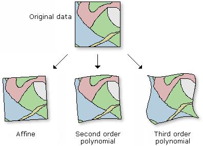
3 1 st order polynomial transformation
4
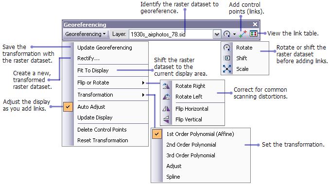
5 Georeferencing toolbar
6 What is the shape of the Earth? Sounds simple enough.
7 Erathosthenes & the circumference of the Earth A short guide to our planet...
8
9 Shape of the Earth Geoid Mathematical figure of the Earth Shape of average ocean surface across the entire Earth Smoother than actual Earth s surface, but highly irregular due to local variations in gravity Ellipsoid Elongated sphere used to represent the Geoid Used for mapping purposes +/- 110m variation from Geoid Geodesy Study of the Earth s shape & representation

10 Shape of the Earth

11 Shape of the Earth Geoid height varies of a global scale +/- 100m In the U.S. geoid height varies from 51m (Atlantic) to 7m (Rockies)

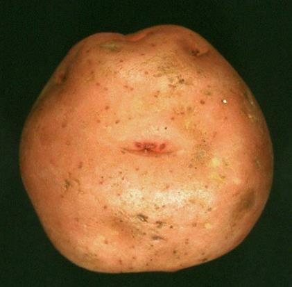
12 Geoid or Potatoid?

13 Shape of the Earth Different ellipsoids are based on different estimates Advent of the GPS has increased our understanding of the Earth s true shape Use Major & Minor axes to determine flattening and eccentricity
14 How do we measure points on the Earth s Ellipsoid? Geographic Coordinate System (GCS)


15 Geographic Coordinate System Uses latitude & longitude to identify location
16 Geographic Coordinate System - Latitude Parallel is a constant line of latitude Equator is 0 latitude and separates the Northern and Southern hemispheres Latitude (degrees, minutes, seconds) (decimal degrees)

17 Geographic Coordinate System - Latitude
18 Geographic Coordinate System - Longitude Meridian is a constant line of longitude Prime Meridian is 0 longitude and separates the Eastern and Western hemispheres International Date Line is 180 longitude sitting opposite of the Prime Meridian. This is where the days start and end.

19 Geographic Coordinate System - Longitude
20 How do we display lat-long on a map? Anytime you translate from a 3D surface to 2D, you must project the coordinate system Lat-long is not a projection and therefore cannot be directly shown on a flat 2D surface (paper map, computer screen) ArcGIS uses the Platte Carree cylindrical projection (the unprojected projection) to represent lat-long
21 Plate Caree Projection The square map
22 Geodetic Datums
23 Geodetic Datums Define Earth s size and shape, as well as the origin and orientation of a coordinate system Based on a set or precisely surveyed points and an ellipsoid Middleman between ellipsoid and coordinate system Ellipsoid > Datum > Lat/Long Nations and agencies use different datums for mapping and as the basis for the different coordinate systems Referencing geodetic coordinates to the wrong datum can result in position errors of hundreds of meters
24 Geodetic Datum Defines Earth s size and shape for a particular location
25 North American Datum 1927 (NAD27) Designed for use in..north America! Based on the Clarke 1866 ellipsoid Created by manually surveying the entire continent based off of a single survey point in Meade Ranch, Kansas Not as accurate as newer datums, which use more precise ellipsoids and more survey points Still used on most USGS topographic map (DRGs & DLGs)
26 North American Datum 1983 (NAD83) Updated datum for.north America! Based on the Geodetic Reference System of 1980 (GRS80), a higher precision ellipsoid Compatible with modern survey techniques using the Earth as a whole not a single point or direction Official datum of the Federal gov t and most states Current version is NAD 83(2011/MA11/PA11) that used highly accurate GPS technology

27 NAD27 v NAD 83
28 World Geodetic Survey 1984 (WGS84) Datum for the whole world Based on the WGS84 Ellipsoid World reference system first developed by the Department of Defense in the 1950s Official datum of inter-continental ballistic missiles (and Google Earth) Used by the US Global Positioning System (NAVSTAR)
29 Geodetic Datums Locations can have different coordinates depending on the datum Bellingham, WA Coordinates (in decimal degrees) Datum Longitude Latitude NAD NAD WGS
30 Components of a GCS
31 Components of GCS Spheroid or Ellipsoid Geodetic Datum Prime Meridian Units of measure

32 Spheroid / Ellipsoid Mathematical representation of the Earth Used to find the average surface of the earth accounts for Mt. Everest (29,000 feet) and depths of oceans Measured in terms of semimajor and semiminor axis

33 Spheroid flattening and axis measurements
34 Geodetic Datum Collection of known and accurate points Both a horizontal and vertical Datum + spheroid change our estimates of where locations are (coordinates) E.g.: NAD 1927, NAD 1983, WGS 1984, JGD 2000, SAD 1969
35 Prime Meridian Line of longitude (North Pole to South Pole) Where X-Coordinate is zero East of PM is positive; west of PM is negative
36 Units of Measure For a GCS, typically decimal degrees or degrees, minutes, seconds

37 Extent in a GCS using DD
38 Extent in a PCS using feet
Intro to GIS Fall 2010 Georeferencing & Map Projections
 Intro to GIS Fall 2010 Georeferencing & Map Projections SHAPE OF THE EARTH Earth's Shape Geoid: shape of earth minus topographic features (irregular due to local variations in gravity) Ellipsoid: elongated
WHERE ARE YOU? Maps & Geospatial Concepts Fall 2012
 WHERE ARE YOU? Maps & Geospatial Concepts Fall 2012 Where are you? Relative location I m at school Absolute Location 45 26 18.07 122 43 50.78 Datums Datums A reference surface of the Earth Used as the
WHERE ARE YOU? Maps & Geospatial Concepts Fall 2015
 WHERE ARE YOU? Maps & Geospatial Concepts Fall 2015 Where are you? Relative location I m at school Absolute Location 45 26 18.07 122 43 50.78 Where is Boston? Introducing Geodesy, Ellipsoids & Geoids Geodesy
Georeferencing. Place names Postal addresses Postal codes Coordinate systems (lat/long, UTM, etc.)
") Georeferencing Georeferencing Used to describe the act of assigning locations to data or information Certain requirements include that they are: unique, have shared meaning, and are persistent through
Georeferencing Georeferencing Used to describe the act of assigning locations to data or information Certain requirements include that they are: unique, have shared meaning, and are persistent through
REFERENCING COORDINATE SYSTEMS MAP PROJECTIONS GEOREFERENCING
 GIS in Ecology SPATIAL REFERENCING COORDINATE SYSTEMS MAP PROJECTIONS GEOREFERENCING : :1 Where on earth? Early mapmakers recognized the need for a system that could locate features on the earth's surface.
NR402 GIS Applications in Natural Resources Lesson 4 Map Projections
 NR402 GIS Applications in Natural Resources Lesson 4 Map Projections From http://www.or.blm.gov/gis/ 1 Geographic coordinates Coordinates are expressed as Latitude and Longitude in Degrees, Minutes, Seconds
Georeferencing, Map Projections, Cartographic Concepts. -Coordinate Systems -Datum
 Georeferencing, Map Projections, Cartographic Concepts -Map Projections -Coordinate Systems -Datum Map projection is "the process of systematically transforming positions on the Earth's spherical surface
What is a Map Projection?
 What is a Map Projection? It is how we represent a three dimensional Earth on a flat piece of paper However The process of transferring information from the Earth to a map causes every projection to distort
Welcome to Lesson 4. It is important for a GIS analyst to have a thorough understanding of map projections and coordinate systems.
 Welcome to Lesson 4. It is important for a GIS analyst to have a thorough understanding of map projections and coordinate systems. A GIS without coordinates would simply be a database like Microsoft Excel
Geographic coordinate systems
 1 Geographic coordinate systems In this chapter you ll learn about longitude and latitude. You ll also learn about the parts that comprise a geographic coordinate system including Spheres and spheroids
A PRIMER ON COORDINATE SYSTEMS Commonly Used in Michigan
 A PRIMER ON COORDINATE SYSTEMS Commonly Used in Michigan David P. Lusch, Ph.D., GISP Department of Geography Remote Sensing & GIS Research and Outreach Services Group Michigan State University September,
GIST 3300 / Geographic Information Systems. Last Time. Today
 GIST 3300 / 5300 Last Time Ellipsoids and Datums Today Map Projections Map Projections Today we will build on the concepts of Geographic Coordinate Systems, Ellipsoids and Datums and add the concepts of
Map projections. Rüdiger Gens
 Rüdiger Gens Coordinate systems Geographic coordinates f a: semi-major axis b: semi-minor axis Geographic latitude b Geodetic latitude a f: flattening = (a-b)/a Expresses as a fraction 1/f = about 300
EnvSci360 Computer and Analytical Cartography
 EnvSci360 Computer and Analytical Cartography Lecture 3 Geodesy Map Projections, Datums, and Coordinate Systems 1 Geodesy The science of measuring and representing the shape and size of the earth, and
Understanding Projections for GIS
 Presented by John Schaeffer Juniper GIS Services, Inc. This PowerPoint is available at JuniperGIS.com Presentation Objectives To understand basic concepts on projections and coordinate systems for the
Projections and Coordinate Systems
 Projections and Coordinate Systems Overview Projections Examples of different projections Coordinate systems Datums Projections Overview Projections and Coordinate Systems GIS must accurately represent
Mapping coordinate systems
 Mapping coordinate systems 1. The Earth's Graticule Latitude and Longitude The graticule is the imaginary grid of lines running east-west (lines of latitude = parallels) and north-south lines of longitude
Control Surveys and Coordinate Systems
 Control Surveys and Coordinate Systems The Earth is Round Basic Shape of the Earth: Oblate Spheroid of Revolution The length of the equatorial axis is approximately 27 miles greater than the polar axis.
Shape e o f f the e Earth
 1 Coordinate Systems & Projections Coordinate Systems Two map layers are not going to register spatially unless they are based on the same coordinate system. 2 Contents Shape of the earth Datum Projections
This week s topics. Week 6. FE 257. GIS and Forest Engineering Applications. Week 6
 FE 257. GIS and Forest Engineering Applications Week 6 Week 6 Last week Chapter 8 Combining and splitting landscape features and merging GIS databases Chapter 11 Overlay processes Questions? Next week
1. Geospatial technology rarely links geospatial data to nonspatial data. a. True *b. False
 Chapter 2 Where in the Geospatial World Are You? 1. Geospatial technology rarely links geospatial data to nonspatial data. 2. For geospatial technology to work, every location on Earth must be: a. inhabited
Georeferencing. Where on earth are we? Critical for importing and combining layers for mapping
 Georeferencing Where on earth are we? Critical for importing and combining layers for mapping 1. The Geoid Earth is not a perfect sphere, it is ellipsoidal.. earth is the 'Geoid'. The difference between
12/26/2012. Geographic Information Systems * * * * GIS (... yrezaei
 ( - Geographic Information Systems ( ( 1 2 3 Information System Data base DB IS IS DB (Knowledge ( ( (System (Information System - (Georefrence Analysis Data + Knowledge ======== Information 4 5 ( < 10%
Lecture 4. Coordinate Systems & Projections
 Lecture 4 Coordinate Systems & Projections Outline Geodesy Geoids Ellipsoids Geographic Coordinate Systems Magnetic North vs. True North Datums Projections Applying Coordinate Systems and Projections Why
Boolean Operators and Topological OVERLAY FUNCTIONS IN GIS
 Boolean Operators and Topological OVERLAY FUNCTIONS IN GIS Query asking a question of the attribute data Standard Query Language (SQL) is used to query the data There are 4 basic statements used to get
Lesson 5: Map Scale and Projections
 Organizing Data and Information Lesson 5: Map Scale and Projections Map Scales Projections Information can be organized as lists, numbers, tables, text, pictures, maps, or indexes. Clusters of information
What is Geodesy? Types of Geodesy terrestrial or classical geodesy space geodesy theoretical geodesy
 What is Geodesy? Geodesy is the study of: The size, shape and motion of the earth The measurement of the position and motion of points on the earth's surface, and The study of the earth's gravity field
Introduction to Geographic Information Science. Updates/News. Last Lecture. Geography 4103 / Map Projections and Coordinate Systems
 Geography 4103 / 5103 Introduction to Geographic Information Science Map Projections and Coordinate Systems Updates/News Thursday s lecture Reading discussion 1 find the readings online open questions,
The Wildlife Society Meet and Greet. Come learn about what the UNBC Student Chapter of TWS is all about!
 Georeferencing I GEOG 300, Lecture 4 Dr. Anthony Jjumba 1 The Wildlife Society Meet and Greet Quiz Come learn about what the UNBC Student Chapter of TWS is all about! 5:30 7:30 PM, Wednesday September
ch02.pdf chap2.pdf chap02.pdf
 Introduction to Geographic Information Systems 8th Edition Karl Solutions Manual Full Download: http://testbanklive.com/download/introduction-to-geographic-information-systems-8th-edition-karl-solutions-manu
Map Projections. Displaying the earth on 2 dimensional maps
 Map Projections Displaying the earth on 2 dimensional maps Map projections Define the spatial relationship between locations on earth and their relative locations on a flat map Are mathematical expressions
Geo Referencing & Map projections CGI-GIRS 0910
 Geo Referencing & Map projections CGI-GIRS 0910 Where are you? 31UFT8361 174,7 441,2 51 58' NB 5 40' OL 2/60 Who are they? 3/60 Do geo data describe Earth s phenomena perfectly? Georeference systems ellipsoid
GEOL 452/552 - GIS for Geoscientists I. Lecture 15
 GEOL 452/552 - GIS for Geoscientists I Lecture 15 Lecture Plan Midterm Multiple choice part graded (+ solutions) Jump to Ch. 11 for one lecture Coordinate systems Projections, datums, spheroids Unprojected
How does an ellipsoid differ from a sphere in approximating the shape and size of the Earth?
 Chapter 02 Test Bank Worksheet Questions 1. What is a map projection? Topic: Map Projection 2. How does an ellipsoid differ from a sphere in approximating the shape and size of the Earth? Topic: Ellipsoid
Geo Referencing & Map projections CGI-GIRS 0910
 Geo Referencing & Map projections CGI-GIRS 0910 Where are you? 31UFT8361 174,7 441,2 51 58' NB 5 40' OL 2/60 Who are they? 3/60 Do geo data describe Earth s phenomena perfectly? Georeference systems ellipsoid
Importance of Understanding Coordinate Systems and Map Projections.
 Importance of Understanding Coordinate Systems and Map Projections. 1 It is extremely important that you gain an understanding of coordinate systems and map projections. GIS works with spatial data, and,
Lecture 2. Map Projections and GIS Coordinate Systems. Tomislav Sapic GIS Technologist Faculty of Natural Resources Management Lakehead University
 Lecture 2 Map Projections and GIS Coordinate Systems Tomislav Sapic GIS Technologist Faculty of Natural Resources Management Lakehead University Map Projections Map projections are mathematical formulas
Working with georeferenced data. What is georeferencing? Coordinate Systems. Geographic and Projected Coordinate System
 GIS501 Fundamentals of Geographical Information Systems (GIS) Coordinate Systems Working with georeferenced data What is georeferencing? Geographically referenced data which is, in some way, referenced
Lecture 10-14: Map Projections and Coordinate System
 URP 1281 Surveying and Cartography Lecture 10-14: Map Projections and Coordinate System December 27, 2015 Course Teacher: Md. Esraz-Ul-Zannat Assistant Professor Department of Urban and Regional Planning
1/28/16. EGM101 Skills Toolbox. Oblate spheroid. The shape of the earth Co-ordinate systems Map projections. Geoid
 EGM101 Skills Toolbox Oblate spheroid The shape of the earth Co-ordinate systems Map projections The geoid is the shape that the surface of the oceans would take under the influence of Earth's gravitation
Map Projections. What does the world look like? AITOFF AZIMUTHAL EQUIDISTANT BEHRMANN EQUAL AREA CYLINDRICAL
 Map Projections What does the world look like? AITOFF AZIMUTHAL EQUIDISTANT BEHRMANN EQUAL AREA CYLINDRICAL 1 CYLINDRICAL EQUAL AREA BONNE CRASTER PARABOLIC 2 ECKERT I ECKERT III ECKERT V There are many
Geographic Information Systems class # 1 February 19, Coordinate reference systems in GIS: geodetic coordinates
 Geographic Information Systems class # 1 February 19, 2013 Coordinate reference systems in GIS: geodetic coordinates Manuel Campagnolo ISA Manuel Campagnolo (ISA) GIS/SIG 2012 2013 February 19, 2013 1
Modern Navigation. Thomas Herring
 12.215 Modern Navigation Thomas Herring Today s Class Latitude and Longitude Simple spherical definitions Geodetic definition: For an ellipsoid Astronomical definition: Based on direction of gravity Relationships
GPS Remote Sensing. GIS Photogrammetry. GEODESY Equipment (total station) CARTOGRAPHY Survey Software. Map Projection Coordinate Systems
 CARTOGRAPHY Survey Software. Map Projection Coordinate Systems") GPS Remote Sensing GIS Photogrammetry GEODESY Equipment (total station) CARTOGRAPHY Survey Software Map Projection Coordinate Systems 1 Coordinate Systems, Datum and Map Projection Dr. Maher A. El-Hallaq
GPS Remote Sensing GIS Photogrammetry GEODESY Equipment (total station) CARTOGRAPHY Survey Software Map Projection Coordinate Systems 1 Coordinate Systems, Datum and Map Projection Dr. Maher A. El-Hallaq
Coordinate Systems. Location on earth is defined by coordinates
 Coordinate Systems We think of the earth as a sphere It is actually a spheroid (ellipsoid), slightly larger in radius at the equator than at the poles Shape of the Earth Location on earth is defined by
The Elements of GIS. Organizing Data and Information. The GIS Database. MAP and ATRIBUTE INFORMATION
 GIS s Roots in Cartography Getting Started With GIS Chapter 2 Dursun Z. Seker MAP and ATRIBUTE INFORMATION Data (numbers and text) store as files refer to them collectively as a database gather inform.
When the Earth Was Flat. Measurements were made using a plumb bob, a spirit level, and a stick. Also, the Stars.
 ABSTRACT Defining the shape of the Earth geoid. Mathematical models spheroid or ellipsoid Mathematical projection of geodetic systems GIS/GPS technology The need for a unified projection systems World
Lecture Plan. GEOL 452/552 - GIS for Geoscientists I. Why use Projections? Lecture 15 - chapter 11. Different types of Projections
 GEOL 452/552 - GIS for Geoscientists I Lecture 15 - chapter 11 Lecture Plan Ch. 11, one lecture Coordinate systems Projection, Datums, Dpheroid Unprojected (geographic) coord. syst., UTM On the fly projection
Introduction to Geography
 Introduction to Geography ropic of Cancer 3½ N Arctic Circle 90 N Prime Meridian 0 Arctic Ocean Mississippi R. Appalachian Mts. Europe Rocky Mountains N. America Atlantic Gulf of Ocean Mexico Caribbean
2. GETTING STARTED WITH GIS
 2. GETTING STARTED WITH GIS What are geographic information systems and what are they used for? ArcGIS: ArcMap, ArcCatalog and ArcToolbox Vector data vs. raster data vs. attribute tables Polygons, polylines,
Projections & GIS Data Collection: An Overview
 Projections & GIS Data Collection: An Overview Projections Primary data capture Secondary data capture Data transfer Capturing attribute data Managing a data capture project Geodesy Basics for Geospatial
Dr. ABOLGHASEM AKBARI Faculty of Civil Engineering & Earth Resources, University Malaysia Pahang (UMP)
") Workshop on : Dr. ABOLGHASEM AKBARI Faculty of Civil Engineering & Earth Resources, University Malaysia Pahang (UMP) 14-15 April 2016 Venue: Tehran, Iran GIS definitions GIS: A simplified view of the real
Workshop on : Dr. ABOLGHASEM AKBARI Faculty of Civil Engineering & Earth Resources, University Malaysia Pahang (UMP) 14-15 April 2016 Venue: Tehran, Iran GIS definitions GIS: A simplified view of the real
4 Survey Datums. 4.1 Horizontal Datum Policy SURVEY DATUMS SEPTEMBER 2006
 4 Survey Datums Today s multi-organizational Project Development efforts require the use of common, accurate horizontal and vertical survey datums and consistent, precise control-survey procedures to ensure
Outline. Shape of the Earth. Geographic Coordinates (φ, λ, z) Ellipsoid or Spheroid Rotate an ellipse around an axis. Ellipse.
 Ellipsoid or Spheroid Rotate an ellipse around an axis. Ellipse.") Map Projections Outline Geodesy and map projections Prof. D. Nagesh Kumar Department of Civil Engineering Indian Institute of Science Bangalore 560 012, India http://www.civil.iisc.ernet.in/~nagesh Shape
Map Projections Outline Geodesy and map projections Prof. D. Nagesh Kumar Department of Civil Engineering Indian Institute of Science Bangalore 560 012, India http://www.civil.iisc.ernet.in/~nagesh Shape
Fri. Jan. 26, Demonstration of QGIS with GPS tracks. Types of data, simple vector (shapefile) formats
 formats") Fri. Jan. 26, 2018 Demonstration of QGIS with GPS tracks Types of data, simple vector (shapefile) formats Map projections, Coordinate Reference Systems Demonstration of QGIS with geologic map 1 Raster
Fri. Jan. 26, 2018 Demonstration of QGIS with GPS tracks Types of data, simple vector (shapefile) formats Map projections, Coordinate Reference Systems Demonstration of QGIS with geologic map 1 Raster
Map Projections & Coordinate Systems
 Map Projections & Coordinate Systems 9/7/2017 1 Why? Laying the Earth Flat Need convenient means of measuring and comparing distances, directions, areas, shapes. Traditional surveying instruments measure
GIS in Water Resources. Fall Homework #1
 GIS in Water Resources Fall 2015 Homework #1 Goal The goal of this homework is to reinforce the lecture material on Geodesy, Map Projections and Coordinate Systems by having you identify attributes and
Latitude and Longitude
 Latitude and Longitude Finding Your Location on a Sphere Coordinate Systems n When you are locating a point on a flat surface you can use Cartesian coordinates of x and y. n The point 2, 3 is plotted on
The Nature of Spatial Data. Keith C. Clarke Geography UCSB
 The Nature of Spatial Data Keith C. Clarke Geography UCSB Geographic primitives G = g (x, y, z, s, A, t) [x, y, z] = f(λ, φ, d) Geography also highly dependent upon model First, the datum (d) Models of
Spatial Reference Systems. Introduction
 Spatial Reference Systems Wolfgang Kainz Professor of Cartography and Geoinformation Department of Geography and Regional Research University of Vienna wolfgang.kainz@univie.ac.at Introduction Historic
The Earth is a Rotating Sphere
 The Earth is a Rotating Sphere The Shape of the Earth Earth s Rotation ( and relative movement of the Sun and Moon) The Geographic Grid Map Projections Global Time The Earth s Revolution around the Sun
Module 2: Mapping Topic 2 Content: Determining Latitude and Longitude Notes
 Introduction In order to more easily locate points on a globe or map, cartographers designed a system of imaginary vertical lines (also called parallels) and horizontal lines (also called meridians) that
GEOIDS FAQ. November
 GEOIDS FAQ 1. What is a geoid? A geoid is a representation of the equipotential surface of the Earth s gravity field. It can be thought of as a surface coinciding with the undisturbed mean sea level extended
Analytical and Computer Cartography Lecture 3: Review: Coordinate Systems
 Analytical and Computer Cartography Lecture 3: Review: Coordinate Systems Geographic Coordinates NAD83 NAD27 remained in use until the earthcentered international GRS80 was complete (Geodetic Reference
Geog Lecture 29 Mapping and GIS Continued
 Geog 1000 - Lecture 29 Mapping and GIS Continued http://scholar.ulethbridge.ca/chasmer/classes/ Today s Lecture (Pgs 13-25, 28-29) 1. Hand back Assignment 3 2. Review of Dr. Peddle s lecture last week
SECTION 4 PARCEL IDENTIFIERS 4.1 LONGITUDE AND LATITUDE
 SECTION 4 PARCEL IDENTIFIERS 4.1 LONGITUDE AND LATITUDE Most maps must be drawn in such a way that points and areas can be located accurately on the earth's surface and described objectively. A uniform
Height systems. Rudi Gens Alaska Satellite Facility
 Rudi Gens Alaska Satellite Facility Outline Why bother about height systems? Relevant terms Coordinate systems Reference surfaces Geopotential number 2 Why bother about height systems? give a meaning to
What is a map? A Map is a two or three-dimensional model or representation of the Earth s surface. 2-Dimensional map
 What is a map? A Map is a two or three-dimensional model or representation of the Earth s surface. 2-Dimensional map What is a Map Projection? Planar Projection Projection A Projection is a mathematical
How do we describe a location on Earth? Geodetic reference system
 How do we describe a location on Earth? Geodetic reference system How do we define the shape of the earth? Definition of the sphere: A three-dimensional surface, all points of which are equidistant from
Coordinate Systems and Datum Transformation in ArcGIS. Brittney White and Melita Kennedy
 Coordinate Systems and Datum Transformation in ArcGIS Brittney White and Melita Kennedy Where is my data? Problem Horizontal Vertical Projections Transformations Horizontal coordinate systems Geographic
Lab #3 Map Projections.
 Lab #3 Map Projections http://visual.merriam-webster.com/images/earth/geography/cartography/map-projections.jpg Map Projections Projection: a systematic arrangement of parallels and meridians on a plane
Tonight. {01} The map. Relative space. What does a map do? Types of maps GEOG 201 2/17/2010. Instructor: Pesses 1
 Tonight {01} The map What makes a map Measuring the Earth Map Interpretation & GPS Spring 2010 M. Pesses What does a map do? Shows where things are Shows spatial (topological) relationships Shows patterns,
2. Which geometric model has been used at some time to describe the earth? a. Sphere b. Oblate ellipsoid c. Flat disk. d. Geoid e.
 01 02 03 04 05 06 07 08 09 10 11 12 13 14 15 16 17 18 19 20 21 22 23 24 25 26 27 28 29 30 31 32 33 34 35 36 37 38 39 40 41 42 43 44 45 46 47 48 49 50 Geography 12 Sample Mid-Term Examination Before you
The World of Geography Pre-Test/Study Guide Chapter 1 Test
 Read each statement or question. On the lines below write the letter of the best answer. 1. Geographers look at the Earth 5. What are the two specific A. by studying cities first. measurements of Earth
Watershed Sciences 4930 & 6920 GEOGRAPHIC INFORMATION SYSTEMS
 Watershed Sciences 4930 & 6920 GEOGRAPHIC INFORMATION SYSTEMS WEEK TWO Lecture PROJECTIONS Joe Wheaton Some of slides in this lecture adapted from content in Paul Bolstad s Fundamentals of GIS HOUSEKEEPING
Referencing map features: Coordinate systems and map projections
 Referencing map features: Coordinate systems and map projections Coordinate systems and map projections if we want to integrate geographic data from many different sources, we need to use a consistent
DIPA Flowchart All you need to know
 DIPA Flowchart All you need to know 0. Overview of Remote Sensing 1. Radiometric correction (Step 1,2,3) System radiometric correction Atmospheric correction Bidirectional correction 2. Geometric registration
Spatial locations. Spatial locations. Spatial locations. Spatial locations
 Where am I? sounds simple, but definitely not huge amount of picky detail Cartographers make a career from the details focus on the minimum you need to know c Philip M. Dixon (Iowa State Univ.) Spatial
Chapter 1 Introduction to the Earth
 Chapter 1 Introduction to the Earth What is Geography? The study of the earth as the home of humankind. Greek - Eratosthenes Father of Geography Geo means Earth Graphy means to write Study how things are
Geographers Perspectives on the World
 What is Geography? Geography is not just about city and country names Geography is not just about population and growth Geography is not just about rivers and mountains Geography is a broad field that
Exercise 6: Coordinate Systems
 Exercise 6: Coordinate Systems This exercise will teach you the fundamentals of Coordinate Systems within QGIS. In this exercise you will learn: How to determine the coordinate system of a layer How the
HP-35s Calculator Program TM 1
 Convert Latitude and Longitude to Transverse Mercator Co-ordinates (UTM, SPCS, etc.) Programmer: Dr. Bill Hazelton Date: April, 2008. Version: 1.0 Mnemonic: T for Transverse Mercator Line Instruction Display
Georeferencing. Geography is the key to linking attributes. Georeferencing is the key to geography.
 Georeferencing Geography is the key to linking attributes. Georeferencing is the key to geography. Why georeferencing? Many reasons for having georeferences Many different approaches to georeferencing
BUILDING AN ACCURATE GIS
 BUILDING AN ACCURATE GIS 2006 GIS in the Rockies Denver, Colorado September 13, 2006 William E. Linzey United States Department of Commerce National Oceanic and Atmospheric Administration National Geodetic
Geodetics: Implications for GIS Professionals May 10, 2018
 Experts in Geomatics, Surveying, Positioning, Geospatial Data, and Mapping Sciences Geodetics: Implications for GIS Professionals May 10, 2018 Michael Barnes APSG Education Foundation Chair 2010-2020 APSG
Introduction to Geographic Information Systems
 Introduction to Geographic Information Systems Lynn_Carlson@brown.edu 401-863-9917 The Environmental And Remote TecHnologies Lab MacMillan Hall, Room 105 http://www.brown.edu/research/earthlab/ Outline
Wed. Apr. 25, 2018 GIS DEMO. Reading: Ch Comparing Image Types (Death Valley) Treat as review of techniques already studied
 Treat as review of techniques already studied") Wed. Apr. 25, 2018 GIS DEMO Reading: Ch. 14 -- Comparing Image Types (Death Valley) Treat as review of techniques already studied 1 GIS: Geographic Information Systems Way to organize data obtained by
Wed. Apr. 25, 2018 GIS DEMO Reading: Ch. 14 -- Comparing Image Types (Death Valley) Treat as review of techniques already studied 1 GIS: Geographic Information Systems Way to organize data obtained by
Introduction to Geography
 Introduction to Geography What is geography? Geography comes from the Greek word Geographia. Geo means earth and graphia means to describe or chart. Geographers study the earth in relation to space and
HP-33S Calculator Program TM 2
 Convert Latitude and Longitude to Transverse Mercator Co-ordinates (UTM, SPCS, etc.) Programmer: Dr. Bill Hazelton Date: April, 2008. Version: 1.0 Mnemonic: T for Transverse Mercator Line Instruction Display
Latitude and Longitude. Begin
 Latitude and Longitude Begin The Earth is divided in two halves, the top half is called the northern hemisphere, and the bottom half is called the southern hemisphere. The dividing line between the two
Coordinate Systems and Map James Frew ESM 263 Winter
 Coordinate Systems and Map Projec@ons 1 Outline Introduc@on La@tude and longitude Projec@ons and coordinate systems Placenames Postal addresses and postal codes Linear referencing systems Cadasters Conver@ng
Military Map Reading 201
 Military Map Reading 201 This information paper is designed to resolve the confusion between the Universal Transverse Mercator (UTM) and the Military Grid Reference System (MGRS) coordinates. The two systems
Cardinal and Intermediate Directions:
 Name Period Parent Signature Due Date: (TBA) Geography/Map Skills Study Guide Continents and Oceans of the World: Label the continents (7) and oceans (4) on the lines below the map. 1 11 3 5 4 8 2 9 10
Appendix B Calculating Pipe Length and Mean Slope from GPS Data
 Appendix B Calculating Pipe Length and Mean Slope from GPS Data B.1 THE BASICS: NORTHING AND EASTING Dimensions of the potential site for a water network can be measured with landbased surveying equipment,
Mapping Earth s Surface Chapter 2 Section 3
 Mapping Earth s Surface Chapter 2 Section 3 Day 1 Objective I will understand maps can be used to find locations on Earth and to represent information about features on Earth s Surface I will understand
PPDM Data Management Symposium March 7, 2012 Houston
 Experts in Geomatics, Surveying, Positioning, Geospatial Data, and Mapping Sciences PPDM Data Management Symposium March 7, 2012 Houston Michael Barnes APSG Foundation Chair 2010-2015 APSG Chair 2008-2009
SIG/GIS: Systèmes d Information Géographiques Geographical Information Systems. Principles
 SIG/GIS: Systèmes d Information Géographiques Geographical Information Systems Principles GEOREFERENCING Outlines 1- Representing Geography 2- The nature of Geographic Data 3- Geo-referencing 4-Uncertainty
3 Geodesy, Datums, Map Projections,
 71 3 Geodesy, Datums, Map Projections, and Coordinate Systems Introduction Geographic information systems are different from other information systems because they contain spatial data. These spatial data
CHAIRMAN OF THE JOINT CHIEFS OF STAFF INSTRUCTION
 CHAIRMAN OF THE JOINT CHIEFS OF STAFF INSTRUCTION J-3 CJCSI 3900.01C DISTRIBUTION: A, B, C, J POSITION (POINT AND AREA) REFERENCE PROCEDURES Reference: DODD 5105.60, 11 October 1996, National Imagery and
Coordinate Systems and Datum Transformations in Action
 Esri International User Conference San Diego, CA Technical Workshops Coordinate Systems and Datum Transformations in Action Melita Kennedy, Geri Pepe July 12, 2011 Objectives Coordinate systems - Geographic