EnvSci360 Computer and Analytical Cartography
|
|
|
- Robert Rodgers
- 6 years ago
- Views:
Transcription
1 EnvSci360 Computer and Analytical Cartography Lecture 3 Geodesy Map Projections, Datums, and Coordinate Systems 1

2 Geodesy The science of measuring and representing the shape and size of the earth, and the study of its gravitational and magnetic fields. EnvSci Lecture 3 2

3 Geodesy & Cartography The principles of geodesy directly relate to map projections and coordinate systems fundamental concepts that determine how you create 2D maps based on the 3D earth. EnvSci Lecture 3 3
4 Fitting the Earth to a plane This much Earth Projection plane Has to fit on this much map surface The projection of a map involves the use of coordinates as defined by projection formulas EnvSci Lecture 3 4
5 A quick look at projections Also see: EnvSci Lecture 3 5

6 Earth Facts Equatorial Diameter: 7, mi. Polar Diameter: 7, mi. Equatorial Circumference: 24, mi. Polar Circumference: 24, mi. Earth is considered an oblate spheroid -- a solid formed when an ellipse is rotated about its axis EnvSci Lecture 3 6

 + Gravitational Pull EnvSci 360 -")
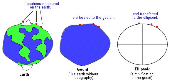
7 The Geoid But even if we assume the earth is an oblate spheroid, we actually model it as a geoid the representation of the earth if the planet were covered only by the oceans. Mean Sea Level (MSL) + Gravitational Pull EnvSci Lecture 3 7

8 The Geoid Gravity varies around the globe, because of variations in density due to magma distributions, mountain ranges, deep sea trenches, etc. So the MSL would not be even everywhere. EGM96 (Earth Gravitational Model 1996) EnvSci Lecture 3 8
 Ellipsoid World Geodetic System 1984 (WGS84) refined the GRS80 for use in GPS EnvSci 360 -")
9 Ellipsoid To simplify projection math, we use a reference ellipsoid to model the earth for mapping - an approximation of the geoid Geodetic Reference System 1980 (GRS 80) Ellipsoid World Geodetic System 1984 (WGS84) refined the GRS80 for use in GPS EnvSci Lecture 3 9

10 Ellipsoid A theoretical surface of the Earth which approximates mean sea level Has 2 axes: Major the axis with the greatest radius Minor the axis with the least radius b a EnvSci Lecture 3 10
11 Ellipsoid Widely used ellipsoids adopted in the U.S.: 1) Clark ellipsoid of 1866 (datum NAD27 (North American Datum of 1927)) 2) Geodetic Reference System (GRS80) (datum NAD83 (North American Datum of 1983)) Original basis for WGS84, which now uses the EGM96 (Earth Gravitational Model 1996) geoid, last revised in 2004 Ellipsoid reference Semi-major axis a Semi-minor axis b Inverse flattening (1/f) Clark ,378,206.4 m 6,356,583.8 m GRS 80 6,378,137.0 m 6,356, m WGS 84 6,378,137.0 m 6,356, m EnvSci Lecture 3 11
12 Sphere, Geoid, Ellipsoid EnvSci Lecture 3 12

13 Geoid, Ellipsoid, Surface Ellipsoid aka reference globe See EnvSci Lecture 3 13
14 Map Projection The systematic mathematical transformation of the three-dimensional curved surface of the Earth to the twodimensional flat surface of a map. Basically, it is how you show the curved 3-D Earth on a flat map. Attempt to accurately depict the following characteristics: 1. Direction 2. Distance 3. Area 4. Shape * No Map Projection can accuracy depict all four characteristics at once. Every map projection will contain some distortion. EnvSci Lecture 3 14
15 Producing Projections Projections may be physically produced by shining a light from the center of the earth onto a developable surface that is being wrapped around or tangent to the reference globe A developable surface (aka flattenable surface) is a geometric shape that may be flattened without stretching its surface - cones, cylinders, and planes EnvSci Lecture 3 15

16 Producing Projections Developable surfaces Flat maps EnvSci Lecture 3 16
17 Producing Projections First step is to create one or more points of contact between the developable surface and the reference globe - these are called points of tangency A tangent projection is one where the developable surface touches in one location EnvSci Lecture 3 17

18 Producing Projections In a secant projection the developable surface intersects the globe in two places EnvSci Lecture 3 18
 or standard longitude")
19 Producing Projections Where the dev. surface touches the globe is important - this is a line of true scale, often referred to as a standard line, such as a line of standard latitude (standard parallel) or standard longitude (central meridian) Distortion is zero along standard lines or points; distortion increases away from these standard locations EnvSci Lecture 3 19
 EnvSci 360 - Lecture")
20 Cylindrical Projection Conceptual View (Tangent) EnvSci Lecture 3 20


21 Cylindrical Projection Conceptual View EnvSci Lecture 3 21

22 Cylindrical Projection - Example Miller's Cylindrical Projection EnvSci Lecture 3 22

23 Cylindrical Projection - Example Cassini's projection is a transverse aspect, here with central meridians at 70 E and 110 W EnvSci Lecture 3 23

24 Conic Projection Conceptual View Secant Conic Projection EnvSci Lecture 3 24

25 Conic Projection -Example How flat maps look when the cone is unfurled EnvSci Lecture 3 25


26 Planar (Azimuthal) Projection Conceptual View Secant Planar Projection EnvSci Lecture 3 26


27 Planar (Azimuthal) Projection - Example Example of a map produced with a planar projection centered on the South Pole EnvSci Lecture 3 27

28 Orthographic Projection Perspective view that depicts a hemisphere of the globe as it appears from outer space EnvSci Lecture 3 28
29 Pseudocylindrical EnvSci Lecture 3 29

30 Other Ways of Categorizing Projections Along with using Cylinders, Cones and Planes to categorize projections, we can also categorize them based on their inherent distortions EnvSci Lecture 3 30
31 Distortion With Projections Shape (Conformality) Distance Direction Area Scale also can be distorted, or differ, throughout a single map Different map projections preserve some of these properties or attempt to reduce the distortion of some or all of these properties, but NO map projection preserves all these properties. EnvSci Lecture 3 31

32 Conformal Projections Conformal projections preserve local shape At every point the scale is the same in every direction Graticule lines intersect at 90-degree angles All angles between intersections of arcs are maintained Shapes of very small areas and angles with very short sides are preserved. Size of many areas are distorted EnvSci Lecture 3 32
33 Equal-area Projections Equal-area projections preserve the relative area of displayed features Every part on the map, as well as the whole, has the same area as the corresponding part on the Earth, at the same reduced scale Shape, angles, scale may be distorted Graticule lines may not meet at 90-degree angles Albers Equal Area EnvSci Lecture 3 33

34 Equal-area Projections EnvSci Lecture 3 34

35 Equal-area Projections EnvSci Lecture 3 35

36 Equidistant Projections Equidistant projections preserve the distances between certain points Scale is maintained along certain lines on map in relation to its reference globe; the distances along these lines are true True distances only from the center of the projection or along special lines No projection is equidistant to and from all points on a map EnvSci Lecture 3 36
37 True-direction Projections True-direction or azimuthal projections preserve the direction of specified points on a great circle The shortest route between two points on a curved surface such as the earth is along the spherical equivalent of a straight line on a flat surface - called the great circle Great circle arcs are rectified, or shown as straight lines Azimuths (angles from a point on a line to another point) are portrayed correctly in all directions See for a good list and examples of different projections EnvSci Lecture 3 37

38 Distortion With Projections Both of these maps are based on equal-area projections, but distances between the same two locations on the globe are not equal 38

39 Comparing Projections EnvSci Lecture 3 39
40 Comparing Projections EnvSci Lecture 3 40
41 Which Projection to Use? Computers do the transformations, but the cartographer s primary task is to choose the proper projection Ask - what is the purpose of the map? Will the projection influence the map s effectiveness? EnvSci Lecture 3 41
42 Which Projection to Use? Guidelines: How the projection s major property (conformality, equivalence, etc.) relates to the map s purpose Amount and arrangement of distortion Is the map part of a series? The overall shape of the projected area - N/S, E/W? The size of the mapped area - world? town? Location of the area - Polar? Mid-latitude? Equatorial? EnvSci Lecture 3 42
43 Which Projection to Use? Equal-area for thematic or distribution maps (statistical mapping) True-direction and/or equidistant for navigational Conformal for presentation maps EnvSci Lecture 3 43

44 Compromise Projections Neither true shapes, true directions, true areas, nor true distances, but a compromise among these properties Attempts to minimize the distortions inherent in some of these properties when others are made to be true EnvSci Lecture 3 44


45 Interrupted Projections A compromise projection, "cutting" the earth s surface along arbitrarily chosen lines and projecting each section separately, which results in less stretching. Interrupted sinusoidal map EnvSci Lecture 3 45


46 Interrupted Projections Goode s Homolosine Projection EnvSci Lecture 3 46


47 Interrupted Projections EnvSci Lecture 3 47

48 Web Mercator Standard for web-based mapping Used by Microsoft Bing Maps, Google Maps, and ESRI ArcGIS Online See bmercatorsmnrbrochure.pdf Mercator%20%28notes%29.pdf EnvSci Lecture 3 48
49 Horizontal Control In order for a projection to be used as a map, a datum must be declared. Datum - a set of quantities to serve as a referent (or point of reference) have an origin measurement based on a datum must be repeatable EnvSci Lecture 3 49
50 Horizontal Control Datum - sets of parameters defining a coordinate system, and a set of control points whose geometric relationships are known, either through measurement or calculations. Simply put, a datum is the mathematical model of the Earth we use to calculate the coordinates on any map, chart, or survey system. All coordinates reference some particular set of numbers (datum) for the size and shape of the Earth. EnvSci Lecture 3 50
51 Horizontal Control In North America: two geodetic datum are commonly used for displaying spatial data: 1. North American Datum of 1983 (NAD83) - based on 250,000 satellite measurements and GRS-80 Ellipsoid & more accurate; has been refined a few times since (e.g. NAD 83( CORS 96) and NAD 83(NSRS2007)) - Units: Meters 2. North American Datum of 1927 (NAD27) - based on 25,000 ground surveys and Clarke 1866 Ellipsoid & less accurate. - Units: Feet EnvSci Lecture 3 51
52 NAD27 vs. NAD83 Shift is shown on USGS Quad maps and will result in map projections from one datum to another. NAD27 NAD83 EnvSci Lecture 3 52
53 Geo-Referencing Systems As mentioned previously, all data displayed and analyzed in a GIS have a spatial component (geographic reference a reference to a location on the earth) In order to display and analyze multiple layers of spatial data for the same geographic area in a GIS, the multiple data layers must be associated with a geo-referencing system (or coordinate system) A coordinate system is closely related to a datum (has an origin) EnvSci Lecture 3 53
54 Geo-Referencing Systems Locate points precisely 2-D (X,Y) or 3-D (X,Y,Z) Two major types used today Geographical (latitude/longitude) - curved Earth Rectangular or Plane (aka Projected)- based on a grid with an origin (i.e. Cartesian coords) - flat map EnvSci Lecture 3 54

55 Geo-Referencing Systems Geographic Grid a.k.a Latitude & Longitude Continuous, 3-D is geo-referenced... but not suitable for 2D mapping (not planar) EnvSci Lecture 3 55

56 Geographical Coordinates EnvSci Lecture 3 56
57 Geographic Coordinates Latitude (y) - north-south distance from the equator - the origin. Also called parallels. Longitude (x) - east-west angular distance from a prime meridian - the origin. Also called meridians. Not a map projection - a set of spherical coordinates used to reference positions on the curved surface of the Earth for use in map projections. Basis for projected coordinate systems EnvSci Lecture 3 57
58 Latitude A function of the angle between the horizon and the North Star Range: 0 90 degrees Origin: The Equator Direction: North and South of the origin EnvSci Lecture 3 58
59 Longitude Comprises meridians (half circles) Range: degrees Origin: The Prime Meridian Direction: East and West of the origin EnvSci Lecture 3 59


60 The Graticule The graticule is the gridded network of latitude and longitude, the pattern that the meridians of longitude and the parallels of latitude form on the surface of the earth. + = EnvSci Lecture 3 60
61 Properties of the Graticule Great Circle - circle created by a plane that intersects 2 points and the center of the Earth (i.e. meridians or the equator) Small Circle - any circle created by an intersecting plane that doesn t cut through the center of the Earth (any parallel other than the equator) EnvSci Lecture 3 61

62 Properties of the Graticule Different ways of creating great circles See 62
63 Measuring Distance The shortest distance between 2 points on a curved surface is the great circle arc above the true connector line Great Circle arc A B True connector line (underground) EnvSci Lecture 3 63
64 Direction on the Graticule Bearing, course, heading, flightline, azimuth are other terms for direction True azimuth - cross meridians at different angles Constant azimuth (rhumb line) - cross meridians at the same angle Direction is important to commercial flight maps EnvSci Lecture 3 64
65 Types of Latitude and Longitude Authalic - measured form the center of the earth; measured on a sphere Authalic latitude 40 Equator 0 Longitude Prime meridian 0 EnvSci Lecture 3 65

66 Types of Latitude and Longitude Geodetic - measured perpendicular to the surface; measured on an ellipsoid EnvSci Lecture 3 66
67 Latitude/Longitude Coordinates 1 - Degrees, minutes, seconds (DMS) dddmmssd or ddd mm'ss" D where ddd = 1-3 digits for degrees, mm = 2 digits for minutes, ss = 2 digits for seconds and D = N,S,E, or W. The seconds and special characters (spaces, apostrophes, quotes) are all optional in this format. This leads to quite a large number of possible valid formats. Ex N W 2 -Decimal degrees (DD) ddd.ffffd where ddd = 0-3 digits, ffff = 0-10 digits and D = N,S,E, or W. This format represents a decimal number of degrees. If the number of degrees is a whole number, the decimal point is optional. Ex N W EnvSci Lecture 3 67
68 Conversion of DMS and DD 360 degrees in a circle 60 minutes to a degree 60 seconds to a minute, so DMS to DD N = N 30/60 =.5 -> /60 =.625 DD to DMS N = N.625 x 60 = x 60 = 30 EnvSci Lecture 3 68
69 Latitude/Longitude Coordinates Remember - positive or negative?? Positive Prime meridian Equator Negative Negative Positive EnvSci Lecture 3 69

70 Geo-Referencing Systems Cartesian A planar coordinate system (X and Y axis) Geo-referenced only when related to the graticule and real-world units are used EnvSci Lecture 3 70

71 Cartesian Coordinates Based on an origin (0,0) and 2 axes (x and y) Read x first, y second x = easting y = northing EnvSci Lecture 3 71
72 Coordinate Systems In GIS, the two most common rectangular coordinate systems used for spatial data in the U.S. are: 1. Universal Transverse Mercator (UTM) 2. State Plane Coordinate System (SPC) Note: Underlying these planar coordinate systems is the latitude/longitude graticule EnvSci Lecture 3 72
73 UTM Coordinate System Universal Transverse Mercator World divided into north/south columns, each 6 longitude wide Origin is central meridian and equator Most widely used coordinate system in the world Primarily used for land masses extending in a northsouth direction Modified for use on USGS Quad maps central meridian of each zone given false easting of equator given false northing of 0 EnvSci Lecture 3 73

74 UTM Coordinate System EnvSci Lecture 3 74
 west of the Central Meridian EnvSci 360 - Lecture 3 75")
75 UTM Coordinate System 60 zones (begin at 180W) Each zone: Comprises 6 Degrees of Longitude Has its own origin In the Northern Hemisphere: origin is at the Equator and 500,000 (m) west of the Central Meridian EnvSci Lecture 3 75

76 UTM Zones in USA EnvSci Lecture 3 76
77 State Plane Coordinates (SPC) Rectangular grid, based on X, Y and false eastings and northings Developed in order to provide local reference systems that were tied to a national datum (i.e. NAD83). A coordinate system, not a projection Some states may have many zones Mass. has Mainland and Island EnvSci Lecture 3 77
 EnvSci 360 - Lecture")
78 State Plane Coordinates (SPC) EnvSci Lecture 3 78
79 False Easting and Northing Arbitrary large values given to x and y axes so that all values in the grid will be positive The origin (0,0) moves to the southwest EnvSci Lecture 3 79

80 Massachusetts State Plane Full domain of MASPC, with false easting and northing UMB Science Building: X: 238,100m Y: 895,960m EnvSci Lecture 3 80
 ISLAND ZONE (FIPSZONE 2002) EnvSci 360 - Lecture")
81 Massachusetts State Plane MAINLAND ZONE (FIPSZONE 2001) ISLAND ZONE (FIPSZONE 2002) EnvSci Lecture 3 81
82 Massachusetts State Plane Zoomed in, shift is evident between zones MAINLAND ZONE ISLAND ZONE The coordinate system used for this map image is Mainland Zone EnvSci Lecture 3 82
 The coordinate system used")
83 Geographic vs. State Plane MAINLAND ZONE SPC USGS QUADS (Geographic) The coordinate system used for this map image is SPC Mainland Zone EnvSci Lecture 3 83

84 3 Grids in Mass. State Plane UTM Lat/Long EnvSci Lecture 3 84
85 Reference Systems Rectangular grids 1 5 A E Simple system used in atlases and on road maps; May be added to ArcMap layouts, along with grids using real (LL, UTM, SP) coordinates EnvSci Lecture 3 85
86 Coordinate System Codes FIPSZONEs for state plane EPSG codes are commonly used to identify a coordinate system European Petroleum Survey Group Also WKIDs (well-known IDs) for GCS html. NAD83 Mass. State Plane Mainland: FIPSZONE = 2001 EPSG = EnvSci Lecture 3 86

87 Projections in ArcGIS All datasets have some coordinate system (aka spatial reference ) although it may not be known (defined) Data in different coordinate systems are projected, or converted from one to another, on the fly, ONLY IF spatial references are properly defined. Use the DEFINE PROJECTION tool if spatial reference is unknown or incorrect If datasets with different spatial references are not properly defined, they will not align properly on the map. The PROJECT tool will create a new dataset with a converted (transformed) coordinate system. PROJECT (vector) PROJECT (raster) DEFINE PROJECTION EnvSci Lecture 3 87
88 Vertical Control Measurements of elevation that may serve as a reference to topographic mapping (i.e. of contour lines or digital elevation models). 2 networks have been devised: National Geodetic Vertical Datum of 1929 North American Vertical Datum of 1988 GPS now determines elevations based on the WGS 84 Ellipsoid latest revision EnvSci Lecture 3 88
89 Vertical Control The relationship between the reference ellipsoid height (h) and the difference (N) between the geoid and the ellipsoid determines vertical height (H). H = h - N Ex. h = 20 N = - 30 H = h - (-30) = 50 GRS 80 Ellipsoid Mean sea-level Geoid Ocean H h N EnvSci Lecture 3 89
Map projections. Rüdiger Gens
 Rüdiger Gens Coordinate systems Geographic coordinates f a: semi-major axis b: semi-minor axis Geographic latitude b Geodetic latitude a f: flattening = (a-b)/a Expresses as a fraction 1/f = about 300
Georeferencing. Place names Postal addresses Postal codes Coordinate systems (lat/long, UTM, etc.)
") Georeferencing Georeferencing Used to describe the act of assigning locations to data or information Certain requirements include that they are: unique, have shared meaning, and are persistent through
Georeferencing Georeferencing Used to describe the act of assigning locations to data or information Certain requirements include that they are: unique, have shared meaning, and are persistent through
Geographic coordinate systems
 1 Geographic coordinate systems In this chapter you ll learn about longitude and latitude. You ll also learn about the parts that comprise a geographic coordinate system including Spheres and spheroids
Introduction to Geographic Information Science. Updates/News. Last Lecture. Geography 4103 / Map Projections and Coordinate Systems
 Geography 4103 / 5103 Introduction to Geographic Information Science Map Projections and Coordinate Systems Updates/News Thursday s lecture Reading discussion 1 find the readings online open questions,
WHERE ARE YOU? Maps & Geospatial Concepts Fall 2015
 WHERE ARE YOU? Maps & Geospatial Concepts Fall 2015 Where are you? Relative location I m at school Absolute Location 45 26 18.07 122 43 50.78 Where is Boston? Introducing Geodesy, Ellipsoids & Geoids Geodesy
Understanding Projections for GIS
 Presented by John Schaeffer Juniper GIS Services, Inc. This PowerPoint is available at JuniperGIS.com Presentation Objectives To understand basic concepts on projections and coordinate systems for the
GIST 3300 / Geographic Information Systems. Last Time. Today
 GIST 3300 / 5300 Last Time Ellipsoids and Datums Today Map Projections Map Projections Today we will build on the concepts of Geographic Coordinate Systems, Ellipsoids and Datums and add the concepts of
Map Projections. What does the world look like? AITOFF AZIMUTHAL EQUIDISTANT BEHRMANN EQUAL AREA CYLINDRICAL
 Map Projections What does the world look like? AITOFF AZIMUTHAL EQUIDISTANT BEHRMANN EQUAL AREA CYLINDRICAL 1 CYLINDRICAL EQUAL AREA BONNE CRASTER PARABOLIC 2 ECKERT I ECKERT III ECKERT V There are many
WHERE ARE YOU? Maps & Geospatial Concepts Fall 2012
 WHERE ARE YOU? Maps & Geospatial Concepts Fall 2012 Where are you? Relative location I m at school Absolute Location 45 26 18.07 122 43 50.78 Datums Datums A reference surface of the Earth Used as the
Shape e o f f the e Earth
 1 Coordinate Systems & Projections Coordinate Systems Two map layers are not going to register spatially unless they are based on the same coordinate system. 2 Contents Shape of the earth Datum Projections
What is a Map Projection?
 What is a Map Projection? It is how we represent a three dimensional Earth on a flat piece of paper However The process of transferring information from the Earth to a map causes every projection to distort
Georeferencing. datum. projection. scale. The next few lectures will introduce you to these elements. on the Earth, you ll need to understand how
 Georeferencing GOAL: To assign a location to all the features represented in our geographic information data In order to do so, we need to make use of the following elements: ellipsoid/geoid To determine
NR402 GIS Applications in Natural Resources Lesson 4 Map Projections
 NR402 GIS Applications in Natural Resources Lesson 4 Map Projections From http://www.or.blm.gov/gis/ 1 Geographic coordinates Coordinates are expressed as Latitude and Longitude in Degrees, Minutes, Seconds
Georeferencing, Map Projections, Cartographic Concepts. -Coordinate Systems -Datum
 Georeferencing, Map Projections, Cartographic Concepts -Map Projections -Coordinate Systems -Datum Map projection is "the process of systematically transforming positions on the Earth's spherical surface
Outline. Shape of the Earth. Geographic Coordinates (φ, λ, z) Ellipsoid or Spheroid Rotate an ellipse around an axis. Ellipse.
 Ellipsoid or Spheroid Rotate an ellipse around an axis. Ellipse.") Map Projections Outline Geodesy and map projections Prof. D. Nagesh Kumar Department of Civil Engineering Indian Institute of Science Bangalore 560 012, India http://www.civil.iisc.ernet.in/~nagesh Shape
Map Projections Outline Geodesy and map projections Prof. D. Nagesh Kumar Department of Civil Engineering Indian Institute of Science Bangalore 560 012, India http://www.civil.iisc.ernet.in/~nagesh Shape
Projections and Coordinate Systems
 Projections and Coordinate Systems Overview Projections Examples of different projections Coordinate systems Datums Projections Overview Projections and Coordinate Systems GIS must accurately represent
Intro to GIS Fall 2010 Georeferencing & Map Projections
 Intro to GIS Fall 2010 Georeferencing & Map Projections SHAPE OF THE EARTH Earth's Shape Geoid: shape of earth minus topographic features (irregular due to local variations in gravity) Ellipsoid: elongated
Map Projections. Displaying the earth on 2 dimensional maps
 Map Projections Displaying the earth on 2 dimensional maps Map projections Define the spatial relationship between locations on earth and their relative locations on a flat map Are mathematical expressions
The Wildlife Society Meet and Greet. Come learn about what the UNBC Student Chapter of TWS is all about!
 Georeferencing I GEOG 300, Lecture 4 Dr. Anthony Jjumba 1 The Wildlife Society Meet and Greet Quiz Come learn about what the UNBC Student Chapter of TWS is all about! 5:30 7:30 PM, Wednesday September
Lesson 5: Map Scale and Projections
 Organizing Data and Information Lesson 5: Map Scale and Projections Map Scales Projections Information can be organized as lists, numbers, tables, text, pictures, maps, or indexes. Clusters of information
Lecture 4. Coordinate Systems & Projections
 Lecture 4 Coordinate Systems & Projections Outline Geodesy Geoids Ellipsoids Geographic Coordinate Systems Magnetic North vs. True North Datums Projections Applying Coordinate Systems and Projections Why
REFERENCING COORDINATE SYSTEMS MAP PROJECTIONS GEOREFERENCING
 GIS in Ecology SPATIAL REFERENCING COORDINATE SYSTEMS MAP PROJECTIONS GEOREFERENCING : :1 Where on earth? Early mapmakers recognized the need for a system that could locate features on the earth's surface.
Importance of Understanding Coordinate Systems and Map Projections.
 Importance of Understanding Coordinate Systems and Map Projections. 1 It is extremely important that you gain an understanding of coordinate systems and map projections. GIS works with spatial data, and,
Map Projections 2/4/2013. Map Projections. Rhumb Line (Loxodrome) Great Circle. The GLOBE. Line of constant bearing (e.g., 292.
 Great Circle. The GLOBE. Line of constant bearing (e.g., 292.") The GLOBE ADVANTAGES Directions True Distances True Shapes True Area True DISADVANTAGES Very small scale with little detail. Costly to reproduce and update. Difficult to carry around. Bulky to store. FACTS
The GLOBE ADVANTAGES Directions True Distances True Shapes True Area True DISADVANTAGES Very small scale with little detail. Costly to reproduce and update. Difficult to carry around. Bulky to store. FACTS
Lecture 10-14: Map Projections and Coordinate System
 URP 1281 Surveying and Cartography Lecture 10-14: Map Projections and Coordinate System December 27, 2015 Course Teacher: Md. Esraz-Ul-Zannat Assistant Professor Department of Urban and Regional Planning
Map Projections & Coordinate Systems
 Map Projections & Coordinate Systems 9/7/2017 1 Why? Laying the Earth Flat Need convenient means of measuring and comparing distances, directions, areas, shapes. Traditional surveying instruments measure
This week s topics. Week 6. FE 257. GIS and Forest Engineering Applications. Week 6
 FE 257. GIS and Forest Engineering Applications Week 6 Week 6 Last week Chapter 8 Combining and splitting landscape features and merging GIS databases Chapter 11 Overlay processes Questions? Next week
Welcome to Lesson 4. It is important for a GIS analyst to have a thorough understanding of map projections and coordinate systems.
 Welcome to Lesson 4. It is important for a GIS analyst to have a thorough understanding of map projections and coordinate systems. A GIS without coordinates would simply be a database like Microsoft Excel
The Elements of GIS. Organizing Data and Information. The GIS Database. MAP and ATRIBUTE INFORMATION
 GIS s Roots in Cartography Getting Started With GIS Chapter 2 Dursun Z. Seker MAP and ATRIBUTE INFORMATION Data (numbers and text) store as files refer to them collectively as a database gather inform.
Lecture 2. Map Projections and GIS Coordinate Systems. Tomislav Sapic GIS Technologist Faculty of Natural Resources Management Lakehead University
 Lecture 2 Map Projections and GIS Coordinate Systems Tomislav Sapic GIS Technologist Faculty of Natural Resources Management Lakehead University Map Projections Map projections are mathematical formulas
Dr. ABOLGHASEM AKBARI Faculty of Civil Engineering & Earth Resources, University Malaysia Pahang (UMP)
") Workshop on : Dr. ABOLGHASEM AKBARI Faculty of Civil Engineering & Earth Resources, University Malaysia Pahang (UMP) 14-15 April 2016 Venue: Tehran, Iran GIS definitions GIS: A simplified view of the real
Workshop on : Dr. ABOLGHASEM AKBARI Faculty of Civil Engineering & Earth Resources, University Malaysia Pahang (UMP) 14-15 April 2016 Venue: Tehran, Iran GIS definitions GIS: A simplified view of the real
ch02.pdf chap2.pdf chap02.pdf
 Introduction to Geographic Information Systems 8th Edition Karl Solutions Manual Full Download: http://testbanklive.com/download/introduction-to-geographic-information-systems-8th-edition-karl-solutions-manu
Applied Cartography and Introduction to GIS GEOG 2017 EL. Lecture-1 Chapters 1 and 2
 Applied Cartography and Introduction to GIS GEOG 2017 EL Lecture-1 Chapters 1 and 2 What is GIS? A Geographic Information System (GIS) is a computer system for capturing, storing, querying, analyzing and
1/28/16. EGM101 Skills Toolbox. Oblate spheroid. The shape of the earth Co-ordinate systems Map projections. Geoid
 EGM101 Skills Toolbox Oblate spheroid The shape of the earth Co-ordinate systems Map projections The geoid is the shape that the surface of the oceans would take under the influence of Earth's gravitation
Map projections. Rüdiger Gens
 Rüdiger Gens 2 Outline! Relevant terms! Why map projections?! Map projection categories " Projection surfaces " Features preserved from distortions! Map projection examples! Right choice Relevant terms!
Introduction to Cartography GEOG 2016 E. Lecture-2 Geodesy and Projections
 Introduction to Cartography GEOG 2016 E Lecture-2 Geodesy and Projections What is Geodesy? The science of geodesy determines: Earth s shape and Interrelation of different points on earth s surface The
Boolean Operators and Topological OVERLAY FUNCTIONS IN GIS
 Boolean Operators and Topological OVERLAY FUNCTIONS IN GIS Query asking a question of the attribute data Standard Query Language (SQL) is used to query the data There are 4 basic statements used to get
2. GETTING STARTED WITH GIS
 2. GETTING STARTED WITH GIS What are geographic information systems and what are they used for? ArcGIS: ArcMap, ArcCatalog and ArcToolbox Vector data vs. raster data vs. attribute tables Polygons, polylines,
Coordinate Systems. Location on earth is defined by coordinates
 Coordinate Systems We think of the earth as a sphere It is actually a spheroid (ellipsoid), slightly larger in radius at the equator than at the poles Shape of the Earth Location on earth is defined by
Lab #3 Map Projections.
 Lab #3 Map Projections http://visual.merriam-webster.com/images/earth/geography/cartography/map-projections.jpg Map Projections Projection: a systematic arrangement of parallels and meridians on a plane
Map Projections. Chapter 4 MAP PROJECTION
 Map Projections Chapter 4 Map Projections What is map projection? Why are map projections drawn? What are the different types of projections? Which projection is most suitably used for which area? In this
Working with georeferenced data. What is georeferencing? Coordinate Systems. Geographic and Projected Coordinate System
 GIS501 Fundamentals of Geographical Information Systems (GIS) Coordinate Systems Working with georeferenced data What is georeferencing? Geographically referenced data which is, in some way, referenced
Geo Referencing & Map projections CGI-GIRS 0910
 Geo Referencing & Map projections CGI-GIRS 0910 Where are you? 31UFT8361 174,7 441,2 51 58' NB 5 40' OL 2/60 Who are they? 3/60 Do geo data describe Earth s phenomena perfectly? Georeference systems ellipsoid
Geographers Perspectives on the World
 What is Geography? Geography is not just about city and country names Geography is not just about population and growth Geography is not just about rivers and mountains Geography is a broad field that
Geo Referencing & Map projections CGI-GIRS 0910
 Geo Referencing & Map projections CGI-GIRS 0910 Where are you? 31UFT8361 174,7 441,2 51 58' NB 5 40' OL 2/60 Who are they? 3/60 Do geo data describe Earth s phenomena perfectly? Georeference systems ellipsoid
1. Geospatial technology rarely links geospatial data to nonspatial data. a. True *b. False
 Chapter 2 Where in the Geospatial World Are You? 1. Geospatial technology rarely links geospatial data to nonspatial data. 2. For geospatial technology to work, every location on Earth must be: a. inhabited
How does an ellipsoid differ from a sphere in approximating the shape and size of the Earth?
 Chapter 02 Test Bank Worksheet Questions 1. What is a map projection? Topic: Map Projection 2. How does an ellipsoid differ from a sphere in approximating the shape and size of the Earth? Topic: Ellipsoid
GEOL 452/552 - GIS for Geoscientists I. Lecture 15
 GEOL 452/552 - GIS for Geoscientists I Lecture 15 Lecture Plan Midterm Multiple choice part graded (+ solutions) Jump to Ch. 11 for one lecture Coordinate systems Projections, datums, spheroids Unprojected
Plane coordinates ~~~~~~~~~~
 Coordinate Systems & Map Projections Geographic coordinates A Basic Introduction to Coordinate Systems & Map Projections Latitude & longitude Angles Parallels & meridians Lines Plane coordinates ~~~~~~~~~~
12/26/2012. Geographic Information Systems * * * * GIS (... yrezaei
 ( - Geographic Information Systems ( ( 1 2 3 Information System Data base DB IS IS DB (Knowledge ( ( (System (Information System - (Georefrence Analysis Data + Knowledge ======== Information 4 5 ( < 10%
Control Surveys and Coordinate Systems
 Control Surveys and Coordinate Systems The Earth is Round Basic Shape of the Earth: Oblate Spheroid of Revolution The length of the equatorial axis is approximately 27 miles greater than the polar axis.
Map Projections (Part 1)
") 1 Earth is a round, maps are not. Four projection families. Equivalent (Equal Area) projections Preserves relative areas Commonly used for thematic maps Ex: Albers Conformal projections Preserve angles,
1 Earth is a round, maps are not. Four projection families. Equivalent (Equal Area) projections Preserves relative areas Commonly used for thematic maps Ex: Albers Conformal projections Preserve angles,
Modern Navigation. Thomas Herring
 12.215 Modern Navigation Thomas Herring Today s class Map Projections: Why projections are needed Types of map projections Classification by type of projection Classification by characteristics of projection
Fri. Jan. 26, Demonstration of QGIS with GPS tracks. Types of data, simple vector (shapefile) formats
 formats") Fri. Jan. 26, 2018 Demonstration of QGIS with GPS tracks Types of data, simple vector (shapefile) formats Map projections, Coordinate Reference Systems Demonstration of QGIS with geologic map 1 Raster
Fri. Jan. 26, 2018 Demonstration of QGIS with GPS tracks Types of data, simple vector (shapefile) formats Map projections, Coordinate Reference Systems Demonstration of QGIS with geologic map 1 Raster
The Nature of Spatial Data. Keith C. Clarke Geography UCSB
 The Nature of Spatial Data Keith C. Clarke Geography UCSB Geographic primitives G = g (x, y, z, s, A, t) [x, y, z] = f(λ, φ, d) Geography also highly dependent upon model First, the datum (d) Models of
GEOGRAPHIC COORDINATE SYSTEMS
 GEOGRAPHIC COORDINATE SYSTEMS Introduction to GIS Winter 2015 What is Georeferencing? Used to establish a location on the Earth s surface 1 st order polynomial transformation Georeferencing toolbar What
Map Projections & Coordinate Systems 9/7/2017
 Map Projections & Coordinate Sstems Laing the Earth Flat Wh? Need convenient means of measuring and comparing distances, directions, areas, shapes. Traditional surveing instruments measure in meters or
Mapping coordinate systems
 Mapping coordinate systems 1. The Earth's Graticule Latitude and Longitude The graticule is the imaginary grid of lines running east-west (lines of latitude = parallels) and north-south lines of longitude
Chapter 3 Models of the Earth. 3.1 Finding Locations on the Earth. 3.1 Objectives
 Chapter 3 Models of the Earth 3.1 Finding Locations on the Earth 3.1 Objectives Explain latitude and longitude. How can latitude and longitude be used to find locations on Earth? How can a magnetic compass
Referencing map features: Coordinate systems and map projections
 Referencing map features: Coordinate systems and map projections Coordinate systems and map projections if we want to integrate geographic data from many different sources, we need to use a consistent
Map Projections & Coordinate Systems 9/10/2013. Why? M. Helper GEO327G/386G, UT Austin 2. M. Helper GEO327G/386G, UT Austin 4
 Map Projections & Coordinates Laing the earth flat Wh? Need convenient means of measuring and comparing distances, directions, areas, shapes. Traditional surveing instruments measure in meters or feet,
Notes on Projections Part II - Common Projections James R. Clynch February 2006
 Notes on Projections Part II - Common Projections James R. Clynch February 2006 I. Common Projections There are several areas where maps are commonly used and a few projections dominate these fields. An
Projections & GIS Data Collection: An Overview
 Projections & GIS Data Collection: An Overview Projections Primary data capture Secondary data capture Data transfer Capturing attribute data Managing a data capture project Geodesy Basics for Geospatial
What is Geodesy? Types of Geodesy terrestrial or classical geodesy space geodesy theoretical geodesy
 What is Geodesy? Geodesy is the study of: The size, shape and motion of the earth The measurement of the position and motion of points on the earth's surface, and The study of the earth's gravity field
Overview key concepts and terms (based on the textbook Chang 2006 and the practical manual)
") Introduction Geo-information Science (GRS-10306) Overview key concepts and terms (based on the textbook 2006 and the practical manual) Introduction Chapter 1 Geographic information system (GIS) Geographically
Introduction Geo-information Science (GRS-10306) Overview key concepts and terms (based on the textbook 2006 and the practical manual) Introduction Chapter 1 Geographic information system (GIS) Geographically
Map Projections & Coordinate Systems 1/25/2018
 Map Projections & Coordinate Sstems Laing the Earth Flat How? Projections transformation of curved earth to a flat map; sstematic rendering of the lat. & lon. graticule to rectangular coordinate sstem.
GPS Remote Sensing. GIS Photogrammetry. GEODESY Equipment (total station) CARTOGRAPHY Survey Software. Map Projection Coordinate Systems
 CARTOGRAPHY Survey Software. Map Projection Coordinate Systems") GPS Remote Sensing GIS Photogrammetry GEODESY Equipment (total station) CARTOGRAPHY Survey Software Map Projection Coordinate Systems 1 Coordinate Systems, Datum and Map Projection Dr. Maher A. El-Hallaq
GPS Remote Sensing GIS Photogrammetry GEODESY Equipment (total station) CARTOGRAPHY Survey Software Map Projection Coordinate Systems 1 Coordinate Systems, Datum and Map Projection Dr. Maher A. El-Hallaq
P R O J E C T I O N S. Map Projections. Introduction to. Map Projections. with. TNTmips. TNTedit TNTview. page 1
 P R O J E C T I O N S Introduction to Map Projections Map Projections with TNTmips page 1 TNTedit TNTview Before Getting Started Positions in a georeferenced spatial object must refer to a particular coordinate
How can we project a 3D globe onto a 2D display? - Ellipsoids and Datums deal with earth non-sphericity
 Map projections How can we project a 3D globe onto a 2D display? - Ellipsoids and Datums deal with earth non-sphericity http://www.mapovasbirka.cz/english/index_eng.html The world could be mapped like
Spatial Data, 16 th Century Dutchmen, GPS and GIS. Martin Charlton, National Centre for Geocomputation National University of Ireland Maynooth
 Spatial Data, 16 th Century Dutchmen, GPS and GIS Martin Charlton, National Centre for Geocomputation National University of Ireland Maynooth Maps as truth Maps are cultural artifacts, comparable in history
2. Which geometric model has been used at some time to describe the earth? a. Sphere b. Oblate ellipsoid c. Flat disk. d. Geoid e.
 01 02 03 04 05 06 07 08 09 10 11 12 13 14 15 16 17 18 19 20 21 22 23 24 25 26 27 28 29 30 31 32 33 34 35 36 37 38 39 40 41 42 43 44 45 46 47 48 49 50 Geography 12 Sample Mid-Term Examination Before you
Georeferencing. Where on earth are we? Critical for importing and combining layers for mapping
 Georeferencing Where on earth are we? Critical for importing and combining layers for mapping 1. The Geoid Earth is not a perfect sphere, it is ellipsoidal.. earth is the 'Geoid'. The difference between
Dirty REMOTE SENSING : Lecture 8 A mapping interlude..
 Dirty REMOTE SENSING : Lecture 8 A mapping interlude.. Stuart Green Teagasc Spatial Analysis Group Stuart.green@teagasc.ie Web for the Week: http://electronics.howstuffworks.com/gps.htm http://www.cstars.ucdavis.edu/classes/ers186-w03/lecture17/lecture17.ppt
Projections Part I - Categories and Properties James R. Clynch February 2006
 I. Introduction and References Projections Part I - Categories and Properties James R. Clynch February 2006 The world is, approximately, a sphere. Maps are flat. Making maps requires some method of putting
Recall: The scale transformation
 Recall: The scale transformation Geography 12: Maps and Spatial Reasoning Lecture 3: Map Projection Basics Professor Keith Clarke 1:400M The real world A representation of the world A cartographic problem
A PRIMER ON COORDINATE SYSTEMS Commonly Used in Michigan
 A PRIMER ON COORDINATE SYSTEMS Commonly Used in Michigan David P. Lusch, Ph.D., GISP Department of Geography Remote Sensing & GIS Research and Outreach Services Group Michigan State University September,
History of Cartography,
 Maps History of Cartography, the art and science of making maps ~2300 BC ~600 BC Early oldest known maps: Babylonian clay tablets. Greek and Roman Ptolemy s (about AD 85-165) "world map" depicted the Old
Map Projections. Which ones best suit your needs?
 1 z 21 2010-02-20 18:38 Map Projections The Globe Mercator Transverse Mercator Oblique Mercator Space Oblique Mercator Miller Cylindrical Robinson Sinusoidal Equal Area Orthographic Stereographic Gnomonic
Lecture Plan. GEOL 452/552 - GIS for Geoscientists I. Why use Projections? Lecture 15 - chapter 11. Different types of Projections
 GEOL 452/552 - GIS for Geoscientists I Lecture 15 - chapter 11 Lecture Plan Ch. 11, one lecture Coordinate systems Projection, Datums, Dpheroid Unprojected (geographic) coord. syst., UTM On the fly projection
Georeferencing. Geography is the key to linking attributes. Georeferencing is the key to geography.
 Georeferencing Geography is the key to linking attributes. Georeferencing is the key to geography. Why georeferencing? Many reasons for having georeferences Many different approaches to georeferencing
Data acquisition and integration 1.
 Data acquisition and integration 1. Ferenc Végső Data acquisition and integration 1.: Ferenc Végső Lector: Árpád Barsi This module was created within TÁMOP - 4.1.2-08/1/A-2009-0027 "Tananyagfejlesztéssel
ArcGIS for Applied Economists Session 2
 ArcGIS for Applied Economists Session 2 Mark Westcott LMU Munich June 15, 2015 1 / 31 Topics for this session: Geographic Coordinate Systems Projections Projected Coordinate Systems Geocoding 2 / 31 Some
Introduction to Geography
 Introduction to Geography ropic of Cancer 3½ N Arctic Circle 90 N Prime Meridian 0 Arctic Ocean Mississippi R. Appalachian Mts. Europe Rocky Mountains N. America Atlantic Gulf of Ocean Mexico Caribbean
Navigation. Longitude and Latitude Foundations of Navigation. MTPs:
 Navigation 3.01 Foundations of Navigation References: FTGU pages 177-178, 184-190 Transport Canada Study and Reference Guide Glider Pilot Canada Flight Training Manual Pilot Navigation http://en.wikipedia.org/wiki/transverse_mercator_projection#spherical_transverse_mercator
Spatial locations. Spatial locations. Spatial locations. Spatial locations
 Where am I? sounds simple, but definitely not huge amount of picky detail Cartographers make a career from the details focus on the minimum you need to know c Philip M. Dixon (Iowa State Univ.) Spatial
What is a map? A Map is a two or three-dimensional model or representation of the Earth s surface. 2-Dimensional map
 What is a map? A Map is a two or three-dimensional model or representation of the Earth s surface. 2-Dimensional map What is a Map Projection? Planar Projection Projection A Projection is a mathematical
GIS in Water Resources. Fall Homework #1
 GIS in Water Resources Fall 2015 Homework #1 Goal The goal of this homework is to reinforce the lecture material on Geodesy, Map Projections and Coordinate Systems by having you identify attributes and
Analytical and Computer Cartography Lecture 3: Review: Coordinate Systems
 Analytical and Computer Cartography Lecture 3: Review: Coordinate Systems Geographic Coordinates NAD83 NAD27 remained in use until the earthcentered international GRS80 was complete (Geodetic Reference
Data acquisition and integration 1.
 University of West Hungary, Faculty of Geoinformatics Ferenc Végső Data acquisition and integration 1. module DAI1 The basics of positioning SZÉKESFEHÉRVÁR 2010 The right to this intellectual property
Spatial Reference Systems. Introduction
 Spatial Reference Systems Wolfgang Kainz Professor of Cartography and Geoinformation Department of Geography and Regional Research University of Vienna wolfgang.kainz@univie.ac.at Introduction Historic
GIS in Water Resources Fall 2018 Homework #1
 GIS in Water Resources Fall 2018 Homework #1 Goal The goal of this homework is to reinforce the lecture material on Geodesy, Map Projections and Coordinate Systems by having you identify attributes and
Test Bank Chapter 2: Representations of Earth
 Multiple Choice Test Bank Chapter 2: Representations of Earth 1. A rhumb line on a Mercator projection is a line of. a. true size b. true shape c. true compass bearing d. true location 2. Maximum longitude
Watershed Sciences 4930 & 6920 GEOGRAPHIC INFORMATION SYSTEMS
 Watershed Sciences 4930 & 6920 GEOGRAPHIC INFORMATION SYSTEMS WEEK TWO Lecture PROJECTIONS Joe Wheaton Some of slides in this lecture adapted from content in Paul Bolstad s Fundamentals of GIS HOUSEKEEPING
GEOREFERENCING, PROJECTIONS Part I. PRESENTING DATA Part II
 Week 7 GEOREFERENCING, PROJECTIONS Part I PRESENTING DATA Part II topics of the week Georeferencing Coordinate systems Map Projections ArcMap and Projections Geo-referencing Geo-referencing is the process
Coordinate Systems and Map James Frew ESM 263 Winter
 Coordinate Systems and Map Projec@ons 1 Outline Introduc@on La@tude and longitude Projec@ons and coordinate systems Placenames Postal addresses and postal codes Linear referencing systems Cadasters Conver@ng
NAVIGATION THEORY QUESTIONS Basics of Navigation
 NAVIGATION THEORY QUESTIONS Basics of Navigation Q610065 look at it The angle between the plane of the ecliptic and the plane of equator is approx? 23.5 degrees In which two months of the year is the difference
Fundamentals of Surveying (LE/ESSE )
") Fundamentals of Surveying (LE/ESSE 2620 3.0) Lecture 2 Basics of Surveying Dr.-Ing. Jian-Guo Wang Geomatics Engineering York University Fall 2017 1 2-1. Overview Part 1: Basics - The Earth s Shape & Size.
Fundamentals of Surveying (LE/ESSE 2620 3.0) Lecture 2 Basics of Surveying Dr.-Ing. Jian-Guo Wang Geomatics Engineering York University Fall 2017 1 2-1. Overview Part 1: Basics - The Earth s Shape & Size.
GLOBES VERSUS FLAT MAPS
 3 Map projections A map projection is a geometrical transformation of the earth's spherical or ellipsoidal surface onto a flat map surface. Much has been written about map projections, yet people still
Tonight. {01} The map. Relative space. What does a map do? Types of maps GEOG 201 2/17/2010. Instructor: Pesses 1
 Tonight {01} The map What makes a map Measuring the Earth Map Interpretation & GPS Spring 2010 M. Pesses What does a map do? Shows where things are Shows spatial (topological) relationships Shows patterns,
Ground Truth Annual Conference. Optimized Design of Low Distortion Projections. Michael L. Dennis, RLS, PE
 Arizona Professional Land Surveyors Association 016 Annual Conference Ground Truth Optimized Design of Low Distortion Projections Michael L. Dennis, RLS, PE Version 3 (rev 1), May 016 Design and metadata