NATRF 2022 AND LDP OCTOBER 11, 2017
|
|
|
- Hugo Jefferson
- 5 years ago
- Views:
Transcription
1 NATRF 2022 AND LDP OCTOBER 11, 2017
2 MODERNIZATION OF THE NSRS Why? Leaving passive control marks behind and relying solely on the CORS network for 3D positions: Older methodology relies on terrestrial (line-of-sight) observations NGS does not have the ability to monitor passive marks, they are easily destroyed NGS no longer has the resources to maintain or replace passive marks Evidence of Systematic Errors: Many years of geodetic observations has revealed systematic errors ranging from decimeters to meters Errors are being noticed and becoming issues with today s more accurate equipment (cm accuracy) NAD 83 is not geocentric with ITRF: GPS and WAAS navigation uses WGS 84 aligned to the ITRF Satellite orbits and other geospatial datasets use global reference frames 2
3 MODERNIZATION OF THE NSRS What s being replaced: Horizontal Horizontal Vertical NORTH AMERICAN TERRESTRIAL REFERENCE FRAME OF 2022 (NATRF 2022) PACIFIC TERRESTRIAL REFERENCE FRAME OF 2022 (PATRF 2022) NAVD 88 MARIANA NAD TERRESTRIAL 83(2011) REFERENCE FRAME OF 2022 (MATRF 2022) CARIBBEAN PRVD 02 NAD 83(MA11) TERRESTRIAL REFERENCE FRAME OF 2022 (CATRF 2022) VIVD09 NAD 83(PA11) ASVD02 Vertical NMVD03 GUVD04 IGLD 85 NORTH AMERICAN-PACIFIC GEOPOTENTIAL DATUM OF 2022 (NAPGD2022) THIS WILL INCLUDE THREE TIME DEPENDENT GEOID MODELS COVERING (GEOID 2022) NORTH AND CENTRAL AMERICA, HAWAII, ALASKA, GREENLAND, AND THE CARIBBEAN AMERICAN SAMOA GUAM AND THE COMMONWEALTH OF THE MARIANA ISLANDS Dru Smith: NGS 3
4 MODERNIZATION OF THE NSRS The new 2022 Reference Frames will be Plate Fixed: The new TRFs will agree with the ITRF (IGSxx) at the initial epoch. The new TRFs will diverge from ITRF by a few cm per year in order to stay plate-fixed. Future adjustments of the TRFs will be in the cm range. Time frames for new realizations and adjustment limits are still being determined. 4
5 5
 Used to compute time-dependent TRF2022 coordinates from timedependent ITRF")
6 MODERNIZATION OF THE NSRS Each frame will get 3 parameters - Euler Pole Latitude - Euler Pole Longitude - Rotation rate (rad/yr) Used to compute time-dependent TRF2022 coordinates from timedependent ITRF coordinates. 6
7 7
8 REPLACING NAD83 (THE HORIZONTAL ELEMENT) Goal is to align NAD 83 with the IGS08 origin of the ellipsoid where the GRS 80 ellipsoid fits on a global scale instead of the North American plate best fit solution we currently have in NAD83. NATRF2022 origin 1.5 meters NAD 83 ORIGIN Identically shaped ellipsoids (GRS-80) a = 6,378, meters (semi-major axis) 1/f = (flattening) Dave Doyle 8


9 LATTITUDE HORIZONTAL AND VERTICAL SHIFT NATRF2022 VS. NAD 83(2011) LONGITUDE ELLIPSOID HEIGHT Dru Smith: NGS 9
 Columbus CORS Station COLB dx = 0.678m or 2.22 ft. dy = 1.410m or 4.")

10 HORIZONTAL AND VERTICAL SHIFT NATRF2022 VS. NAD 83(2011) Columbus CORS Station COLB dx = 0.678m or 2.22 ft. dy = 1.410m or 4.62 ft. dz = 0.086m or 0.28 ft. Image of Helipad at ODOT HQ near COLB CORS Station Red Line: NAD 83 imagery on NAD 83 reference frame Green Line: Shift of Helipad to NATRF2022 but image remains on NAD 83 10
11 MODERNIZATION OF THE NSRS REPLACING NAVD 88 NAPGD2022 NORTH AMERICAN-PACIFIC GEOPOTENTIAL DATUM OF 2022 NEW DATUM BASED ON GRAVITY MODELS (THE GEOID) No passive marks/can use GNSS to position a benchmark GNSS BASED VERTICAL DATUM: Users with geodetic quality receivers can use OPUS or RTNs/ RTK to establish Orthometric Heights LEVELING NO LONGER REQUIRED TO ESTABLISH BENCHMARKS 11
12 MODERNIZATION OF THE NSRS REPLACING NAVD 88 ACCESS: easier to find the sky than a 60-year-old bench mark GNSS equipment is cheap and fast ACCURACY: easier to trust the sky than a 60-year old bench mark immune to passive mark instability Proposed accuracy of 2 cm over much of the United States GLOBAL STANDARDS: systematic errors of many meters across the US aligns with GPS, international efforts aligns with Canada, Mexico 12

13 MODERNIZATION OF THE NSRS TRANSITION TO THE FUTURE: GRAV-D Gravity for the Redefinition of the American Vertical Datum Official NGS policy as of Nov 14, 2007 $38.5M over 10 years Airborne Gravity Snapshot Absolute Gravity Tracking Re-define the Vertical Datum of the USA by 2022 Approximately 62% Complete (Sept. 2017) 13

14 MODERNIZATION OF THE NSRS GRAV D PROGRESS Green: Available data and metadata Blue: Data being processed Orange: Data collection underway White: Planned for data collection 14

15 REPLACING NAVD88 GRAV-D GRAVITY FOR THE REDEFINITION OF THE AMERICAN VERTICAL DATUM GRAV-D PROJECT Errors exist in NAVD 88: 50cm average 100cm CONUS tilt 1-2m average in Alaska Changing from a leveling-based to geoid/gnss-based vertical datum requires an updated accurate, nationwide gravity survey using airborne gravity meters. 15
16 ODOT S EFFORTS TO IMPLEMENT LOW DISTORTION MAP PROJECTIONS FOR ODOT PROJECTS 16


17 WORKING WITH STATE PLANE COORDINATES OR HOW TO MAKE THE EARTH FLAT SURVEYORS AND MAP MAKERS HAVE HAD TO CREATE MAPS OF THE EARTH FOR CENTURIES. THE WAY WE DRAW A CURVED SURFACE ON A FLAT PLAIN IS BY USING MAP PROJECTIONS. AS SURVEYORS WE ARE AWARE THAT WE CANNOT REPRESENT A CURVED SURFACE ON A FLAT PLAIN WITHOUT SOME DISTORTION. 17
18 THE CURRENT STATE PLANE COORDINATE SYSTEM Linear distortion due to Earth s curvature Projection surface (secant) Ellipsoid surface Grid length greater than ellipsoidal length (distortion > 0) Grid length less than ellipsoidal length (distortion < 0) Maximum projection zone width for balanced positive and negative distortion 18
19 THE CURRENT STATE PLANE COORDINATE SYSTEM Linear distortion due to Elevation Ground surface Projection surface (secant) Ellipsoid surface Grid length greater than ellipsoidal length (distortion > 0) Grid length less than ellipsoidal length (distortion < 0) Maximum projection zone width for balanced positive and negative distortion 19
20 THE CURRENT STATE PLANE COORDINATE SYSTEM ISSUES WITH THE USE OF CURRENT STATE PLANE COORDINATE SYSTEM: CURRENT STATE PLANE COORDINATE SYSTEM DESIGNED AT 1 : 10,000 ACCURACY TODAYS EQUIPMENT IS MUCH MORE ACCURATE THAN THIS OAC : SETS THE MINIMUM STANDARD FOR BOUNDARY SURVEYS AT 1 : 10,000 MINIMUM ACCURACY. THIS EATS UP YOUR ERROR BUDGET RATHER QUICKLY GRID DISTANCES DO NOT REFLECT TRUE GROUND DISTANCES NEED TO SCALE PROJECTS TO MINIMIZE DISTORTION BETWEEN GRID AND GROUND THIS SCALING IS DONE ON A PROJECT BY PROJECT BASIS NO STANDARD SCALE FACTOR USED FOR MULTIPLE PROJECTS PROJECTS IN CLOSE PROXIMITRY TO EACH OTHER HAVE DIFFERENT SCALE FACTORS AND DO NOT FIT EACH OTHER DOES NOT WORK SEAMLESSLY WITH OTHER PRODUCTS (GOOGLE EARTH, ESRI, OSIP IMAGERY, CADD PLATFORMS) 20
21 THE CURRENT STATE PLANE COORDINATE SYSTEM IS IT TIME TO RE-THINK STATE PLANE COORDINATES? CAN WE DEVELOP A COORDINATE SYSTEM THAT WOULD ESSENTIALLY ELIMINATE DISTORTION (OR MAKE IT SO INSIGNIFICANT THAT IT CAN BE IGNORED)? CAN WE WORK SEAMLESSLY BETWEEN OUR GPS EQUIPMENT AND TOTAL STATION WITHOUT CALCULATING A SCALE FACTOR? CAN WE INCORPORATE GIS DATA INTO OUR SURVEYS (OR INCORPORATE OUR SURVEYS INTO GIS) SEAMLESSLY? 21
22 THE CURRENT STATE PLANE COORDINATE SYSTEM THE ANSWER IS: YES WE CAN! HOW? 22


23 THE CURRENT STATE PLANE COORDINATE SYSTEM LET S RE-THINK HOW WE PROJECT LAT/LONG TO PLANE COORDINATES


24 THE CURRENT STATE PLANE COORDINATE SYSTEM BY LOOKING AT OUR STATE IN A DIFFERENT WAY INSTEAD OF DIVIDING OHIO INTO TWO ZONES (NORTH AND SOUTH) LET S LOOK AT HOW CURVATURE AND ELEVATION AFFECT LINEAR DISTORTION:
25 MAXIMUM ZONE WIDTH FOR SECANT PROJECTIONS MAXIMUM LINEAR HORIZONTAL DISTORTION MILES Parts per Million Feet per Mile Ratio 35 MILES ± 5 ppm ± 0.03ft. / mile 1 : 200, MILES ± 10 ppm ± 0.05ft. / mile 1 : 100, MILES ± 20 ppm ± 0.10ft. / mile 1 : 50, MILES ± 50 ppm ± 0.30ft. / mile 1 : 20, MILES ± 100 ppm ± 0.50ft. / mile 1 : 10,000 Dave Minkel and Michael Dennis NGS/NOAA 25
26 HEIGHT ABOVE AND BELOW PROJECTION SURFACE LINEAR DISTORTION DUE TO ELEVATION FEET Parts per Million Feet per Mile Ratio ± 100 ft. ± 4.8 ppm ± 0.03ft. / mile 1 : 209,000 ± 400 ft. ± 19 ppm ± 0.10ft. / mile 1 : 52,000 ±1,000 ft. ± 48 ppm ± 0.25ft. / mile 1 : 21,000 Dave Minkel and Michael Dennis NGS/NOAA 26
27 LOW DISTORTION MAP PROJECTION Ground surface Typical State Plane surface Low Distortion surface Ellipsoid surface Grid length greater than ellipsoidal length (distortion > 0) Grid length less than ellipsoidal length (distortion < 0) Typical State Plane Zone width for balanced positive and negative distortion Dave Minkel and Michael Dennis NGS/NOAA 27

28 LOW DISTORTION MAP PROJECTIONS MAHONING PROJECTIONS ARE DESIGNED BASED ON THE SHAPE OF THE COUNTY. COUNTIES THAT LIE PREDOMINANTLY EAST AND WEST RECEIVE LAMBERT CONFORMAL CONIC PROJECTIONS COUNTIES THAT LIE PREDOMINANTLY NORTH AND SOUTH RECEIVE TRANSVERSE MERCATOR PROJECTIONS 28

29 LOW DISTORTION MAP PROJECTIONS SUMMIT PROJECTIONS ARE DESIGNED BASED ON THE SHAPE OF THE COUNTY. COUNTIES THAT LIE PREDOMINANTLY NORTH AND SOUTH RECEIVE TRANSVERSE MERCATOR PROJECTIONS 29
 Calculate your Scale Factor using one of the various methods outlined in the Survey and Mapping Specifications and enter it into the Data Collector 3.")
30 The current workflow WORKFLOW 1.) Select your system (NAD83) and your Zone (Ohio North or South) 2.) Calculate your Scale Factor using one of the various methods outlined in the Survey and Mapping Specifications and enter it into the Data Collector 3.) Enter the Coordinates you are going to scale about (0,0) VERY IMPORTANT STEP!!! 30
 Select ODOT LDS 2.")
31 WORKFLOW The Low Distortion System workflow 1.) Select ODOT LDS 2.) Select the county you are working in 31


32 LOW DISTORTION MAP PROJECTIONS WHERE ARE WE AND WHERE ARE WE GOING? MAP PROJECTIONS FOR ALL 88 COUNTIES ARE COMPLETE. CURRENTLY CONDUCTING FIELD TESTS FOR QUALITY CONTROL AND ASSURANCE. PROJECTING TESTING TO BE COMPLETED BY JULY 1, MAKE ADJUSTMENTS TO PROJECTIONS AND UP-DATE MAPS BY DECEMBER MAKE PROJECTIONS AVAILABLE ON CADD AND MAPPING WEB SITE. 32
33 QUESTIONS Last updated 10/19/
MODERNIZATION OF THE NSRS
 NATRF 2022 AND LDP SEPTEMBER 12, 2017 MODERNIZATION OF THE NSRS Why? Leaving passive control marks behind and relying solely on the CORS network for 3D positions: Older methodology relies on terrestrial
New Datums: Replacing NAVD 88 and NAD 83
 New Datums: Replacing NAVD 88 and NAD 83 By Dave Zenk PE, LS National Geodetic Survey Northern Plains Regional Advisor 1735 Lake Drive West Chanhassen, MN 55317-8581 952-368-2548 office 612-414-9522 mobile
Modernization of the National Spatial Reference System 2022 Datum. Jacksonville Chapter July 2018
 Modernization of the National Spatial Reference System 2022 Datum Jacksonville Chapter July 2018 Randy Tompkins, PSM, PLS Geomatics Project Manager Surveyor, Hydrographer, & Geodesist DRMP, Inc. Jacksonville,
NGS and the Modernization of the National Spatial Reference System (NSRS)
") NGS and the Modernization of the National Spatial Reference System (NSRS) Dr. Dana Caccamise Pacific Southwest Region (CA,NV) Geodetic Advisor dana.caccamise@noaa.gov NOAA s National Geodetic Survey geodesy.noaa.gov
NGS and the Modernization of the National Spatial Reference System (NSRS) Dr. Dana Caccamise Pacific Southwest Region (CA,NV) Geodetic Advisor dana.caccamise@noaa.gov NOAA s National Geodetic Survey geodesy.noaa.gov
The U.S. National Spatial Reference System in 2022
 Presented at the, May 29 - June 2, 2017 in The U.S. National Spatial Reference System in 2022 Daniel R. Roman, (Chief Geodesist) NOAA s National Geodetic Survey 1 Why change? Outline Naming conventions
New Datums: Replacing NAVD 88 and NAD 83
 New Datums: Replacing NAVD 88 and NAD 83 Professional Surveyors Association of Nebraska Winter Seminar Dave Zenk NGS Advisor February 9, 2018 Kearney, NE February 9, 2018 Professional Surveyors Association
U.S. Datums: Where We ve Been,
 U.S. Datums: Where We ve Been, Where We re Going Modernizing the National Spatial Reference System Matt Wellslager RFA, South Carolina Geodetic Survey Presentation Outline 1. - Introductions. 2. - National
Positioning a nation for the future: Modernizing the United States National Spatial Reference System
 Positioning a nation for the future: Modernizing the United States National Spatial Reference System Dr. Dana Caccamise USA Representative Pacific Southwest Region Geodetic Advisor dana.caccamise@noaa.gov
Frames for the Future New Datum Definitions for Modernization of the U.S. National Spatial Reference System
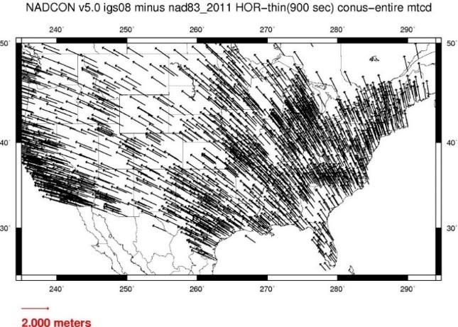
 Figure 10. Horizontal position differences (in meters) between NAD 83 and ITRF 08 at time 2022.00 (January 1, 2022). Positional differences are shown for the North American and Pacific tectonic plates.
MSGIC Spring Mtg Denton April 23, 2014
 Modernization of the National Spatial Reference System Keeping Pace with Changes in Positioning Technology and User Expectations in a Dynamic World MSGIC Spring Mtg Denton April 23, 2014 Dave Doyle Base
Changes are coming NGS NSRS Modernization Are you Ready?
 Changes are coming NGS 2022 - NSRS Modernization Are you Ready? Pam Fromhertz Rocky Mountain Regional Advisor Pamela.Fromhertz@noaa.gov 240-988-6363 John Hunter CO State Geomatics Coordinator DRCOG March
The National Spatial Reference System of the Future
 The National Spatial Reference System of the Future William Stone Southwest Region (AZ, NM, NV, UT) Geodetic Advisor william.stone@noaa.gov NOAA s National Geodetic Survey geodesy.noaa.gov Salt Lake City
HORIZONTAL PROJECTION PARAMETERS: DANE COUNTY COORDINATES
 Recommended RTK GPS Configuration Parameters for the City of Madison, WI Base Station Compiled by: Dan Rodman RLS, City of Madison (608)266-6674 drodman@cityofmadison.com For base station information see
Positioning the Pacific: NOAA s Geospatial Activities. Juliana Blackwell, Director NOAA s National Geodetic Survey March 6, 2012
 Positioning the Pacific: NOAA s Geospatial Activities Juliana Blackwell, Director NOAA s National Geodetic Survey March 6, 2012 A Common Problem of the Early 19 th Century 1807 President Thomas Jefferson
Control Surveys and Coordinate Systems
 Control Surveys and Coordinate Systems The Earth is Round Basic Shape of the Earth: Oblate Spheroid of Revolution The length of the equatorial axis is approximately 27 miles greater than the polar axis.
Fusion of Geodesy and GIS at NOAA s National Geodetic Survey
 Fusion of Geodesy and GIS at NOAA s National Geodetic Survey Esri Survey Summit July 6-9, 2013 San Diego, CA Michael Dennis, RLS, PE michael.dennis@noaa.gov The Plan Background NGS Data Explorer New Datasheet
BUILDING AN ACCURATE GIS
 BUILDING AN ACCURATE GIS 2006 GIS in the Rockies Denver, Colorado September 13, 2006 William E. Linzey United States Department of Commerce National Oceanic and Atmospheric Administration National Geodetic
The Future of SPCS in Charles Chuck Ghilani, Ph.D. Professor Emeritus Pennsylvania State University
 The Future of SPCS in 2022 Charles Chuck Ghilani, Ph.D. Professor Emeritus Pennsylvania State University Class Etiquette Turn off all cell phones Or set them to vibrate Go out of the room to answer any
4 Survey Datums. 4.1 Horizontal Datum Policy SURVEY DATUMS SEPTEMBER 2006
 4 Survey Datums Today s multi-organizational Project Development efforts require the use of common, accurate horizontal and vertical survey datums and consistent, precise control-survey procedures to ensure
The U.S. National Spatial Reference System in 2022
 The U.S. National Spatial Reference System in 2022 Daniel ROMAN, U.S.A. Key words: Capacity Building; GNSS/GPS; Legislation; Positioning; Reference Frames; Reference Systems; Standards SUMMARY In 2022,
Session description and objectives
 Journey to the Moving Center of the Earth The Evolution of the National Spatial Reference System NJSPLS SurvCon 2018 January 31, 2018 Dan Martin Northeast Regional Geodetic Advisor ME, NH, VT, MA, CT,
United States NSRS 2022: Terrestrial Reference Frames
 United States NSRS 2022: Terrestrial Reference Frames Daniel ROMAN, U.S.A. Key words: Capacity building; Positioning; Reference frames; Reference systems, Cadastre SUMMARY In 2022, the United States will
This week s topics. Week 6. FE 257. GIS and Forest Engineering Applications. Week 6
 FE 257. GIS and Forest Engineering Applications Week 6 Week 6 Last week Chapter 8 Combining and splitting landscape features and merging GIS databases Chapter 11 Overlay processes Questions? Next week
NGS is Scheduled to Replace NAVD 88 and NAD 83 In 2022
 NGS is Scheduled to Replace NAVD 88 and NAD 83 In 2022 Indiana Society of Professional Land Surveyors Conference January 2017 John Ellingson NGS Geodetic Advisor john.ellingson@noaa.gov 202-306-6904 1
Map projections. Rüdiger Gens
 Rüdiger Gens Coordinate systems Geographic coordinates f a: semi-major axis b: semi-minor axis Geographic latitude b Geodetic latitude a f: flattening = (a-b)/a Expresses as a fraction 1/f = about 300
Ground Truth Annual Conference. Optimized Design of Low Distortion Projections. Michael L. Dennis, RLS, PE
 Arizona Professional Land Surveyors Association 016 Annual Conference Ground Truth Optimized Design of Low Distortion Projections Michael L. Dennis, RLS, PE Version 3 (rev 1), May 016 Design and metadata
The Future of SPCS in 2022
 The Future of SPCS in 2022 Charles Chuck Ghilani, Ph.D. Professor Emeritus Pennsylvania State University Class Etiquette Turn off all cell phones Or set them to vibrate Go out of the room to answer any
VT State Plane. Daniel J. Martin National Geodetic Survey VT Geodetic Advisor. VSLS Conference Rutland VT April 11, 2008
 VT State Plane Daniel J. Martin National Geodetic Survey VT Geodetic Advisor VSLS Conference Rutland VT April 11, 2008 Today s Outline Define the problem Review of VT State Plane System Relationship
Introduction to Geographic Information Science. Updates/News. Last Lecture. Geography 4103 / Map Projections and Coordinate Systems
 Geography 4103 / 5103 Introduction to Geographic Information Science Map Projections and Coordinate Systems Updates/News Thursday s lecture Reading discussion 1 find the readings online open questions,
Lecture 2. Map Projections and GIS Coordinate Systems. Tomislav Sapic GIS Technologist Faculty of Natural Resources Management Lakehead University
 Lecture 2 Map Projections and GIS Coordinate Systems Tomislav Sapic GIS Technologist Faculty of Natural Resources Management Lakehead University Map Projections Map projections are mathematical formulas
Georeferencing. Place names Postal addresses Postal codes Coordinate systems (lat/long, UTM, etc.)
") Georeferencing Georeferencing Used to describe the act of assigning locations to data or information Certain requirements include that they are: unique, have shared meaning, and are persistent through
Georeferencing Georeferencing Used to describe the act of assigning locations to data or information Certain requirements include that they are: unique, have shared meaning, and are persistent through
GISC3325 Spring 2011 Final Exam
 GISC3325 Spring 2011 Final Exam Name: Carefully read each question. Identify the important elements and the question being asked. Show your work for partial credit. No credit for undocumented wrong answers.
Shape e o f f the e Earth
 1 Coordinate Systems & Projections Coordinate Systems Two map layers are not going to register spatially unless they are based on the same coordinate system. 2 Contents Shape of the earth Datum Projections
WHERE ARE YOU? Maps & Geospatial Concepts Fall 2015
 WHERE ARE YOU? Maps & Geospatial Concepts Fall 2015 Where are you? Relative location I m at school Absolute Location 45 26 18.07 122 43 50.78 Where is Boston? Introducing Geodesy, Ellipsoids & Geoids Geodesy
ch02.pdf chap2.pdf chap02.pdf
 Introduction to Geographic Information Systems 8th Edition Karl Solutions Manual Full Download: http://testbanklive.com/download/introduction-to-geographic-information-systems-8th-edition-karl-solutions-manu
Town of Chino Valley. Survey Control Network Report. mgfneerhg mc N. Willow Creek Road Prescott AZ
 Town of Chino Valley Survey Control Network Report mgfneerhg mc. 2050 N. Willow Creek Road Prescott AZ 86301 928-771-2376 Page 1 of 70 Table of Contents Town of Chino Valley Survey Datum Outline A short
Spatial Data Collection using GPS: BEST PRACTICES
 Spatial Data Collection using GPS: BEST PRACTICES - 2007 Page 1 of 10 Best practices for GPS & Spatial Data Collection, Storage and Documentation These Best Practices are designed to maximize positional
Solving the "Grid to Ground Problem" with Custom Coordinate Systems CV327-6 About the Speaker:
 Solving the "Grid to Ground Problem" with Custom Coordinate Systems Richard Sincovec, LSI Director of Technology, Edward James Surveying President, Quux Software CV327-6 Grid projections such as the State
Understanding Projections for GIS
 Presented by John Schaeffer Juniper GIS Services, Inc. This PowerPoint is available at JuniperGIS.com Presentation Objectives To understand basic concepts on projections and coordinate systems for the
A PRIMER ON COORDINATE SYSTEMS Commonly Used in Michigan
 A PRIMER ON COORDINATE SYSTEMS Commonly Used in Michigan David P. Lusch, Ph.D., GISP Department of Geography Remote Sensing & GIS Research and Outreach Services Group Michigan State University September,
WHERE ARE YOU? Maps & Geospatial Concepts Fall 2012
 WHERE ARE YOU? Maps & Geospatial Concepts Fall 2012 Where are you? Relative location I m at school Absolute Location 45 26 18.07 122 43 50.78 Datums Datums A reference surface of the Earth Used as the
NR402 GIS Applications in Natural Resources Lesson 4 Map Projections
 NR402 GIS Applications in Natural Resources Lesson 4 Map Projections From http://www.or.blm.gov/gis/ 1 Geographic coordinates Coordinates are expressed as Latitude and Longitude in Degrees, Minutes, Seconds
Georeferencing, Map Projections, Cartographic Concepts. -Coordinate Systems -Datum
 Georeferencing, Map Projections, Cartographic Concepts -Map Projections -Coordinate Systems -Datum Map projection is "the process of systematically transforming positions on the Earth's spherical surface
Practical considerations for determining Euler Pole Parameters for the terrestrial reference frames in the United States
 Practical considerations for determining Euler Pole Parameters for the terrestrial reference frames in the United States Jacob M. HECK and Dru A. SMITH, United States Key words: GNSS/GPS, Positioning,
What is a Map Projection?
 What is a Map Projection? It is how we represent a three dimensional Earth on a flat piece of paper However The process of transferring information from the Earth to a map causes every projection to distort
Ground Truth Annual Conference. Design and Documentation of Low Distortion Projections for Surveying and GIS
 Professional Land Surveyors of Oregon 15 Annual Conference Ground Truth Design and Documentation of Low Distortion Projections for Surveying and GIS Michael L Dennis, RLS, PE v. (rev 1), January 15, Design
Map Projections. What does the world look like? AITOFF AZIMUTHAL EQUIDISTANT BEHRMANN EQUAL AREA CYLINDRICAL
 Map Projections What does the world look like? AITOFF AZIMUTHAL EQUIDISTANT BEHRMANN EQUAL AREA CYLINDRICAL 1 CYLINDRICAL EQUAL AREA BONNE CRASTER PARABOLIC 2 ECKERT I ECKERT III ECKERT V There are many
Making Sense of Evolving Reference Frames for North America
 Making Sense of Evolving Reference Frames for North America Mike Craymer Geodetic Survey Division, Natural Resources Canada Giovanni Sella U.S. National Geodesy Survey American Geophysical Union 2007 Joint
Analytical and Computer Cartography Lecture 3: Review: Coordinate Systems
 Analytical and Computer Cartography Lecture 3: Review: Coordinate Systems Geographic Coordinates NAD83 NAD27 remained in use until the earthcentered international GRS80 was complete (Geodetic Reference
REFERENCING COORDINATE SYSTEMS MAP PROJECTIONS GEOREFERENCING
 GIS in Ecology SPATIAL REFERENCING COORDINATE SYSTEMS MAP PROJECTIONS GEOREFERENCING : :1 Where on earth? Early mapmakers recognized the need for a system that could locate features on the earth's surface.
Lesson 5: Map Scale and Projections
 Organizing Data and Information Lesson 5: Map Scale and Projections Map Scales Projections Information can be organized as lists, numbers, tables, text, pictures, maps, or indexes. Clusters of information
Intro to GIS Fall 2010 Georeferencing & Map Projections
 Intro to GIS Fall 2010 Georeferencing & Map Projections SHAPE OF THE EARTH Earth's Shape Geoid: shape of earth minus topographic features (irregular due to local variations in gravity) Ellipsoid: elongated
Vertical Reference Frame Pacific
 Vertical Reference Frame Pacific Andrick Lal SPC Geoscience Division GIS&RS User Conference 29 th November 2016 USP, Fiji. What does it mean? All buildings and features have a height. But what is it relative
How does an ellipsoid differ from a sphere in approximating the shape and size of the Earth?
 Chapter 02 Test Bank Worksheet Questions 1. What is a map projection? Topic: Map Projection 2. How does an ellipsoid differ from a sphere in approximating the shape and size of the Earth? Topic: Ellipsoid
Geodesy on the move. Craig Allinson. Dealing with dynamic coordinate reference systems. IOGP Geodesy Subcommittee. EPUG London, November 2017
 Geodesy on the move Dealing with dynamic coordinate reference systems Craig Allinson IOGP Geodesy Subcommittee EPUG London, November 2017 Why the concern? A bridge too far Historic geodesy mental image
GIST 3300 / Geographic Information Systems. Last Time. Today
 GIST 3300 / 5300 Last Time Ellipsoids and Datums Today Map Projections Map Projections Today we will build on the concepts of Geographic Coordinate Systems, Ellipsoids and Datums and add the concepts of
EnvSci360 Computer and Analytical Cartography
 EnvSci360 Computer and Analytical Cartography Lecture 3 Geodesy Map Projections, Datums, and Coordinate Systems 1 Geodesy The science of measuring and representing the shape and size of the earth, and
Height systems. Rudi Gens Alaska Satellite Facility
 Rudi Gens Alaska Satellite Facility Outline Why bother about height systems? Relevant terms Coordinate systems Reference surfaces Geopotential number 2 Why bother about height systems? give a meaning to
Low Distortion Projections Part 2 Ground versus Grid
 Blue Marble Geographic Calculator provides an incredible variety of tools for working with an infinite combination of datums and projections. Shown here, I ve entered the parameters for a Low Distortion
Geog Lecture 29 Mapping and GIS Continued
 Geog 1000 - Lecture 29 Mapping and GIS Continued http://scholar.ulethbridge.ca/chasmer/classes/ Today s Lecture (Pgs 13-25, 28-29) 1. Hand back Assignment 3 2. Review of Dr. Peddle s lecture last week
Achieving Great Height with GNSS
 Achieving Great Height with GNSS Oregon GPS Users Group 2015 Annual Meeting January 23, 2015 Salem, Oregon Salem Convention Center Michael Dennis, RLS, PE Oregon State University National Geodetic Survey
1. Geospatial technology rarely links geospatial data to nonspatial data. a. True *b. False
 Chapter 2 Where in the Geospatial World Are You? 1. Geospatial technology rarely links geospatial data to nonspatial data. 2. For geospatial technology to work, every location on Earth must be: a. inhabited
Outline. Shape of the Earth. Geographic Coordinates (φ, λ, z) Ellipsoid or Spheroid Rotate an ellipse around an axis. Ellipse.
 Ellipsoid or Spheroid Rotate an ellipse around an axis. Ellipse.") Map Projections Outline Geodesy and map projections Prof. D. Nagesh Kumar Department of Civil Engineering Indian Institute of Science Bangalore 560 012, India http://www.civil.iisc.ernet.in/~nagesh Shape
Map Projections Outline Geodesy and map projections Prof. D. Nagesh Kumar Department of Civil Engineering Indian Institute of Science Bangalore 560 012, India http://www.civil.iisc.ernet.in/~nagesh Shape
Update on GRAV-D and Progress toward a new vertical Datum
 Update on GRAV-D and Progress toward a new vertical Datum New York Association of Professional Land Surveyors January 17, 201 Dan Martin Northeast Regional Geodetic Advisor ME, NH, VT, MA, CT, RI, NY,
Importance of Understanding Coordinate Systems and Map Projections.
 Importance of Understanding Coordinate Systems and Map Projections. 1 It is extremely important that you gain an understanding of coordinate systems and map projections. GIS works with spatial data, and,
12/26/2012. Geographic Information Systems * * * * GIS (... yrezaei
 ( - Geographic Information Systems ( ( 1 2 3 Information System Data base DB IS IS DB (Knowledge ( ( (System (Information System - (Georefrence Analysis Data + Knowledge ======== Information 4 5 ( < 10%
Map Projections. Displaying the earth on 2 dimensional maps
 Map Projections Displaying the earth on 2 dimensional maps Map projections Define the spatial relationship between locations on earth and their relative locations on a flat map Are mathematical expressions
Geographic coordinate systems
 1 Geographic coordinate systems In this chapter you ll learn about longitude and latitude. You ll also learn about the parts that comprise a geographic coordinate system including Spheres and spheroids
Boolean Operators and Topological OVERLAY FUNCTIONS IN GIS
 Boolean Operators and Topological OVERLAY FUNCTIONS IN GIS Query asking a question of the attribute data Standard Query Language (SQL) is used to query the data There are 4 basic statements used to get
Welcome to Lesson 4. It is important for a GIS analyst to have a thorough understanding of map projections and coordinate systems.
 Welcome to Lesson 4. It is important for a GIS analyst to have a thorough understanding of map projections and coordinate systems. A GIS without coordinates would simply be a database like Microsoft Excel
Projections and Coordinate Systems
 Projections and Coordinate Systems Overview Projections Examples of different projections Coordinate systems Datums Projections Overview Projections and Coordinate Systems GIS must accurately represent
TOWARDS ROBUST LOCALIZATION OF RTK-GPS TOPOGRAPHIC SURVEYS 23
 TOWARDS ROBUST LOCALIZATION OF RTK-GPS TOPOGRAPHIC SURVEYS Jerry W. Nave, North Carolina A&T University; Tarig A. Ali, American University of Sharjah Abstract Localization is performed to fit the observed
Preventing Coordinate- System Confusion (maybe?)
") Preventing Coordinate- System Confusion (maybe?) Montana Association of Registered Land Surveyors 2008 Convention Bozeman, Montana 07 & 08 February 2008 Glenn Borkenhagen Inland GPS Inc. - Cody, Wyoming
Preventing Coordinate- System Confusion (maybe?) Montana Association of Registered Land Surveyors 2008 Convention Bozeman, Montana 07 & 08 February 2008 Glenn Borkenhagen Inland GPS Inc. - Cody, Wyoming
When the Earth Was Flat. Measurements were made using a plumb bob, a spirit level, and a stick. Also, the Stars.
 ABSTRACT Defining the shape of the Earth geoid. Mathematical models spheroid or ellipsoid Mathematical projection of geodetic systems GIS/GPS technology The need for a unified projection systems World
Meeting the ODOT Survey & Mapping Specifications
 Meeting the ODOT Survey & Mapping Specifications A Simple Solution Presented by Ray Foos, P.S, ODOT CADD & Mapping Services & Jon Keller, P.S., ODOT District 3 Phases of an ODOT Survey Project Research
What is Geodesy? Types of Geodesy terrestrial or classical geodesy space geodesy theoretical geodesy
 What is Geodesy? Geodesy is the study of: The size, shape and motion of the earth The measurement of the position and motion of points on the earth's surface, and The study of the earth's gravity field
GPS Remote Sensing. GIS Photogrammetry. GEODESY Equipment (total station) CARTOGRAPHY Survey Software. Map Projection Coordinate Systems
 CARTOGRAPHY Survey Software. Map Projection Coordinate Systems") GPS Remote Sensing GIS Photogrammetry GEODESY Equipment (total station) CARTOGRAPHY Survey Software Map Projection Coordinate Systems 1 Coordinate Systems, Datum and Map Projection Dr. Maher A. El-Hallaq
GPS Remote Sensing GIS Photogrammetry GEODESY Equipment (total station) CARTOGRAPHY Survey Software Map Projection Coordinate Systems 1 Coordinate Systems, Datum and Map Projection Dr. Maher A. El-Hallaq
GEOGRAPHIC COORDINATE SYSTEMS
 GEOGRAPHIC COORDINATE SYSTEMS Introduction to GIS Winter 2015 What is Georeferencing? Used to establish a location on the Earth s surface 1 st order polynomial transformation Georeferencing toolbar What
This presentation covers the following areas
 Geodetic Datums and Coordinate Systems for Surveying and Mapping in Hong Kong FIG Working Week 2012 Rome, Italy 6-10 May Simon KWOK Hong Kong, China 1 This presentation covers the following areas Explains
HP-35s Calculator Program Lambert 1
 Convert Latitude and Longitude to Lambert Conformal Conic Projection Co-ordinates (SPCS) Programmer: Dr. Bill Hazelton Date: July, 2010. Version: 1.2 Line Instruction Display User Instructions N001 LBL
GEOID12A for LGO. September, Leica Geosystems Incorporated
 GEOID12A for LGO September, 2012 Leica Geosystems Incorporated 1. INTRODUCTION: The GEOID12A model can be used in LGO for geoid undulation calculations based on NAD83 Latitudes and Longitudes. The GEOID12A
Lecture 4. Coordinate Systems & Projections
 Lecture 4 Coordinate Systems & Projections Outline Geodesy Geoids Ellipsoids Geographic Coordinate Systems Magnetic North vs. True North Datums Projections Applying Coordinate Systems and Projections Why
The Elements of GIS. Organizing Data and Information. The GIS Database. MAP and ATRIBUTE INFORMATION
 GIS s Roots in Cartography Getting Started With GIS Chapter 2 Dursun Z. Seker MAP and ATRIBUTE INFORMATION Data (numbers and text) store as files refer to them collectively as a database gather inform.
Coordinate Systems and Datum Transformation in ArcGIS. Brittney White and Melita Kennedy
 Coordinate Systems and Datum Transformation in ArcGIS Brittney White and Melita Kennedy Where is my data? Problem Horizontal Vertical Projections Transformations Horizontal coordinate systems Geographic
2. GETTING STARTED WITH GIS
 2. GETTING STARTED WITH GIS What are geographic information systems and what are they used for? ArcGIS: ArcMap, ArcCatalog and ArcToolbox Vector data vs. raster data vs. attribute tables Polygons, polylines,
Georeferencing. Geography is the key to linking attributes. Georeferencing is the key to geography.
 Georeferencing Geography is the key to linking attributes. Georeferencing is the key to geography. Why georeferencing? Many reasons for having georeferences Many different approaches to georeferencing
Proceedings of the First International Conference on Civil Engineering, Assiut University, Volume 2, pp , October 7-8.
 Proceedings of the First International Conference on Civil Engineering, Assiut University, Volume 2, pp. 246-253, October 7-8. PRODUCTIVE GPS TOPOGRAPHIC MAPPING FOR NATIONAL DEVELOPMENT PROJECTS IN EGYPT
The Wildlife Society Meet and Greet. Come learn about what the UNBC Student Chapter of TWS is all about!
 Georeferencing I GEOG 300, Lecture 4 Dr. Anthony Jjumba 1 The Wildlife Society Meet and Greet Quiz Come learn about what the UNBC Student Chapter of TWS is all about! 5:30 7:30 PM, Wednesday September
Lecture 10-14: Map Projections and Coordinate System
 URP 1281 Surveying and Cartography Lecture 10-14: Map Projections and Coordinate System December 27, 2015 Course Teacher: Md. Esraz-Ul-Zannat Assistant Professor Department of Urban and Regional Planning
Height Modernization 2013 A New Canadian Vertical Datum
 Height Modernization 2013 A New Canadian Vertical Datum What is Height Modernization? The Height Reference System Modernization is a project at the Geodetic Survey Division (GSD) of Natural Resources Canada
Approaches to GNSS & Geodesy
 Approaches to GNSS & Geodesy Ray Hintz Univ. of Maine Ray.hintz@.maine.edu The biggest complaint about state plane coordinates The concept that scale and elevation factor need to be applied to the pythagoreum
GEODETIC NETWORK OF SAUDI ARABIA AND FIDUCIAL STATIONS. GFN OF Saudi Arabia in Based on ITRF2000 Datum
 STUDIES OF TECTONIC MOVEMENTS IN SAUDI ARABIA USING CORS M. Al Rajhi, Ali Al Omar, R. Yanar, F. Kartal, K. Eren, SUBJECT TO TALKS BACKGROUND GEODETIC NETWORK OF SAUDI ARABIA AND FIDUCIAL STATIONS GFN OF
Geospatial Data Standards Considerations for the delivery of 2D and 3D spatial data February 2019
 Geospatial Data Standards Considerations for the delivery of 2D and 3D spatial data February 2019 Prepared by: GRCA Geomatics Version Date Summary of Changes Changes Made By: 1.00 March 16, 2018 Version
Projections & GIS Data Collection: An Overview
 Projections & GIS Data Collection: An Overview Projections Primary data capture Secondary data capture Data transfer Capturing attribute data Managing a data capture project Geodesy Basics for Geospatial
GRAV-D. Gravity for the Re-definition of the American Vertical Datum
 GRAV-D Gravity for the Re-definition of the American Vertical Datum Why this briefing? NGS recently acquired a new airborne gravimeter Intended to support GRAV-D GRAV-D is an ambitious new plan for NGS
Geographic Information Systems class # 1 February 19, Coordinate reference systems in GIS: geodetic coordinates
 Geographic Information Systems class # 1 February 19, 2013 Coordinate reference systems in GIS: geodetic coordinates Manuel Campagnolo ISA Manuel Campagnolo (ISA) GIS/SIG 2012 2013 February 19, 2013 1
Lecture Plan. GEOL 452/552 - GIS for Geoscientists I. Why use Projections? Lecture 15 - chapter 11. Different types of Projections
 GEOL 452/552 - GIS for Geoscientists I Lecture 15 - chapter 11 Lecture Plan Ch. 11, one lecture Coordinate systems Projection, Datums, Dpheroid Unprojected (geographic) coord. syst., UTM On the fly projection
Height Modernization Program in the United States: Implementing a Vertical Datum Referenced to a Gravimetric Geoid Model
 Height Modernization Program in the United States: Implementing a Vertical Datum Referenced to a Gravimetric Geoid Renee Shields, Christine Gallagher, USA Key words: GNSS, orthometric height, elevation,
Inclusion of Leveling with GNSS Observations in a Single, 3-D Geodetic Survey Network Adjustment. Daniel GILLINS, U.S.A., and Michael DENNIS, U.S.A.
 Inclusion of Leveling with GNSS Observations in a Single, 3-D Geodetic Survey Network Adjustment Daniel GILLINS, U.S.A., and Michael DENNIS, U.S.A. Key words: Leveling, Integrated Geodesy, Geoid Accuracy,
Positioning in the Pacific Islands
 Positioning in the Pacific Islands Andrick Lal United Nations/Nepal Workshop on the Applications of Global Navigation Satellite Systems Kathmandu - Nepal 15 th December 2016 Presentation Outline Introduction