Report for 15th PCGIAP Meeting at 18th UNRCC-AP Working Group 1 Regional Geodesy
|
|
|
- Noreen Allen
- 6 years ago
- Views:
Transcription
1 Report for 15th PCGIAP Meeting at 18th UNRCC-AP Working Group 1 Regional Geodesy Chairman Shigeru Matsuzaka, Japan - shigeru@gsi.go.jp Vice Chairman Prof. Pengfei Cheng, China - chengpf@casm.ac.cn John Manning, Australia - manning@bigpond.net.au 26 October 2009, Bangkok Thailand
2 Working Group 1: Regional Geodesy Role of WG1: Establishment of a regional vertical geodetic datum Enhancement of a regional geodetic infrastructure through annual cooperative campaigns Improvement to the regional geoid Implementation of an absolute gravity reference system Development of transformation parameters for spatial data Geodetic technology transfer to Pacific Islands nations
3 Resolutions endorsed at the 17th UNRCC-AP/ 12th PCGIAP meeting in Bangkok, September Enhance the regional geodetic infrastructure to contribute to monitoring, warning and post-event reconstructions through cooperative observations of crustal deformation and plate motion, and information exchange, including tide gauge networks and placement of new GPS key sites. 2. Encourage the transfer of GPS technology to nations in need through annual campaign observations, and the development and sharing of analysis techniques in the following geodesy workshop activities. 3. Promote the application of new geodetic adjustment techniques and datum change transformation parameters for regional spatial data integration and for geo-referencing cadastral and statistical information.
4 Resolutions (cont d) 4. Interact with IAG commissions 1 and 2 on the status of the regional geodetic reference frames and geoid determination using absolute gravity, satellite, airborne and terrestrial gravity. 5. Review the status of geodetic networks in individual countries and upgrade PCGIAP web site information. 6. Support the expansion of continuous GPS installations in areas of earthquake and tsunami hazards and strongly encourages nations making such data readily available on a weekly basis for shared scientific study and warning systems in relation to tectonic events.
5 Topics in Working Group Activities (1/5) Asia Pacific Regional Geodetic Project :APRGP Annual one-week GNSS/GPS campaign to connect national networks, obtain site velocities. Other space techniques - SLR & VLBI incorporated. APRGP 2006 through 2009 conducted by the coordination of Geoscience Australia (GA). GA analysis team has carried out preliminary reprocessing of the APRGP data sets for Coordinates and velocities available on request.

6 APRGP and IGS stations used in the 2008 campaign analysis

7 The estimated horizontal velocity field for the Asia-Pacific region
8 Appendix: Recent Earthquake Activities Significant earthquakes with fatalities in the region ; Southern Sumatra, Indonesia M Solomon Islands M Central Honshu, Japan M Southern Sumatra, Indonesia - M Simeulue, Indonesia - M Eastern Sichuan, China - M 7.9 Fatalities 87,652 (InSAR image by GSI) Eastern Honshu, Japan - M Kyrgyzstan M Minahasa, Sulawesi, Indonesia M Java, Indonesia M Samoa Islands region - M 8.0 Fatalities > Southern Sumatra, Indonesia - M 7.6 Fatalities > 1,000 Seismic gap near Padang along the Sunda trench. Sep eq. does not fill the gap

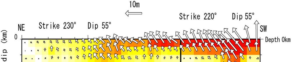
9 Crustal Deformation and Source Fault of the Sichuan (Wenchuan) Earthquake, China, May 12, 2008, M7.9 InSAR image disclosed the length and position of the source fault. Length was estimated as 285±5km. Large deformation is along the Longmen Shan fault zone.


10 Fault model of the Sichuan (Wenchuan) Earthquake The fault was reverse type with right lateral component. Max. slip was about 11m near Beichuan ( 北川 ).
11

12 Earthquakes along Sunda Trench Mega and large earthquakes occurred in covering most of the area (~2,300 km) along the Sunda trench. 10.png There still exists a seismic gap about 370 km in length off Padang. An earthquake with magnitude over 8.5 occurred in this area in 1797.
13 Topic in Working Group Activities (2/5) International cooperation Australia: GA as coordinator for IAG regional dense velocity solution. Contribution of PCGIAP solution to ITRF. Korea: Korean geoid development project. Cooperation with NGS, USA.
14 Topics in Working Group Activities (3/5) Geodetic network & reference system China: national geodetic reference has became geocentric in 2008 (CGCS2000) Korea: 44 CGPS stations operated by National Geographic Information Institute (NGII) with networkbased RTK service as of 2008
15 Topics in Working Group Activities (4/5) Expansion of continuous GPS (CGPS) Steady progress across the region China, Japan, Korea, Singapore, Malaysia, Australia, New Zealand, Turkey, etc. New projects starting
16 Topics in Working Group Activities (5/5) On going projects in the region Australia: AuScope Indonesia: IndCORS Japan: Asia-Pacific crustal monitoring project Korea: a new geodetic VLBI ( ) New Zealand: a new geodetic VLBI (2008) South Pacific Sea level monitoring project. 12 CGPS collocated with tide gauges.
17 Future activities Need to invigorate the regional geodesy WG to respond to the expected roles and activities Acknowledging Substantial number of GPS/GNSS networks in the region Inhomogeneous infrastructure and poor data sharing Propose a new project for regional geodesy
18 Future activities (cont d) The Asia-Pacific Reference Frame (APREF) Project Coordinated geodetic activity of the region Regional densification of the terrestrial reference frame based on continuous GPS tracking stations Crustal deformation monitoring possible EUREF Network as a model Development and evolution of the APRGP activity into the future

19 APRGP Observations (1997~ ) GPS
 Real-time data service Positional reference in Japan as well as monitoring of")
20 Japan s GEONET (GPS Earth Observation Network, 1996~ ) >1200 permanent GPS stations (average spacing: 20km) Real-time data service Positional reference in Japan as well as monitoring of deformations

21 AuScope Geodetic Network (2009~ ) New network of VLBI, SLR and 100+GPS

22 EUREF Permanent Network
23 Proposed Structure of APREF Steering Committee 1 x Chair 3 x APREF participants 1 x PCGIAP representative 1 x IAG representative 1 x Central Bureau representative Users Who: PCGIAP, government agencies, IAG, FIG, research community and private sector Central Bureau Tasks: coordination of analysis and data-flow, user interaction, advice to the Steering Committee Data Centre Analysis Centre Data Centre Analysis Centre GNSS Network Operator GNSS Network Operator
Reference frames and positioning
 The APREF Project: an Improved Geodetic Infrastructure for Asia and the Pacific (4861) John Dawson (Australia), Graeme Blick (New Zealand), Manoj Deo, Guorong Hu and Gary Johnston (Australia) Reference
Report of PCGIAP to the 18 th United Nations Regional Cartographic Conference for Asia and the Pacific (UNRCC-AP) for the period
 for the period") Permanent Committee on GIS Infrastructure for Asia and the Pacific (PCGIAP) Established in 1995 by a United Nations Resolution Report of PCGIAP to the 18 th United Nations Regional Cartographic Conference
Permanent Committee on GIS Infrastructure for Asia and the Pacific (PCGIAP) Established in 1995 by a United Nations Resolution Report of PCGIAP to the 18 th United Nations Regional Cartographic Conference
Working Group 1. Geodetic Reference Frame. Activity Report. for. The UN-GGIM-AP Plenary Meeting
 Regional Committee of United Nations Global Geospatial Information Management for Asia and the Pacific (UN-GGIM-AP) Established by a United Nations Resolution Working Group 1 Geodetic Reference Frame Activity
Background Document: Report of the Regional Committee of United Nations Global Geospatial Information Management for Asia and the Pacific
 Background Document: Report of the Regional Committee of United Nations Global Geospatial Information Management for Asia and the Pacific 1. Summary 1. This report highlights the activities carried out
Report of the Regional Committee of UN-GGIM for Asia and the Pacific (UN-GGIM-AP)
") Report of the Regional Committee of UN-GGIM for Asia and the Pacific (UN-GGIM-AP) At the Eighth Session of UN-GGIM UN Headquarters, New York, 1 3 August 2018 About UN-GGIM-AP One of the five regional committees
Report of the Regional Committee of UN-GGIM for Asia and the Pacific (UN-GGIM-AP) At the Eighth Session of UN-GGIM UN Headquarters, New York, 1 3 August 2018 About UN-GGIM-AP One of the five regional committees
CORS Network and Datum Harmonisation in the Asia-Pacific Region. Richard Stanaway and Craig Roberts
 CORS Network and Datum Harmonisation in the Asia-Pacific Region Richard Stanaway and Craig Roberts School of Surveying and Spatial Information Systems University of New South Wales CORS Networks in the
REGIONAL REFERENCE FRAMES: THE IAG PERSPECTIVE
 REGIONAL REFERENCE FRAMES: THE IAG PERSPECTIVE João Agria Torres SPUIAGG IAG Sub-commission 1.3: Regional Reference Frames jatorres@iol.pt 1. About the IAG CONTENT 2. Objectives and organization of SC
ECONOMIC AND SOCIAL COUNCIL
 UNITED NATIONS E/CONF.102/3 ECONOMIC AND SOCIAL COUNCIL Nineteenth United Nations Regional Cartographic Conference for Asia and the Pacific Bangkok, 29 October 1 November 2012 Item 4 of the provisional
From Global to National Geodetic Reference Frames: how are they connected and why are they needed?
 From Global to National Geodetic Reference Frames: how are they connected and why are they needed? Zuheir ALTAMIMI Institut National de l Information Géographique et Forestière, France Vice-President,
Economic and Social Council
 KLOO-OOOQ UNITED NATIONS E Economic and Social Council Distr LIMITED E/CONF.92/L. 11 11 April 2000 ORIGINAL: ENGLISH FIFTEENTH UNITED NATIONS REGIONAL CARTOGRAPHIC CONFERENCE FOR ASIA AND THE PACIFIC Kuala
From PCGIAP to UN GGIM AP: A Regional Perspective on GGIM
 Regional Committee of United Nations Global Geospatial Information Management for Asia and the Pacific (UN-GGIM-AP) Established by a United Nations Resolution From PCGIAP to UN GGIM AP: A Regional Perspective
Report on the Actions Taken on Resolutions of the Eighteenth United Nations Regional Cartographic Conference for Asia and the Pacific
 UNITED NATIONS E/CONF.102/7 ECONOMIC AND SOCIAL COUNCIL Nineteenth United Nations Regional Cartographic Conference for Asia and the Pacific Bangkok, 29 October 1 November 2012 Item 4 of the provisional
Semi-Dynamic Datum of Indonesia
 Technical Seminar Reference Frame in Practice, Semi-Dynamic Datum of Indonesia H.Z. Abidin, A.B. Wijanarto, S.T. Wibowo, Susilo, J. Efendi Geospatial Information Agency, Indonesia (BIG) Sponsors: Page
The Global Geodetic Observing System (GGOS) of the International Association of Geodesy (IAG)
 of the International Association of Geodesy (IAG)") The Global Geodetic Observing System (GGOS) of the International Association of Geodesy (IAG) Hermann Drewes Representative of the International Union of Geodesy and Geophysics (IUGG) to the Cartographic
The Global Geodetic Observing System (GGOS) of the International Association of Geodesy (IAG) Hermann Drewes Representative of the International Union of Geodesy and Geophysics (IUGG) to the Cartographic
A Strategic Plan for Geodesy in Sweden. Mikael Lilje Lars E. Engberg Geodesy Department Lantmäteriet Sweden
 A Strategic Plan for Geodesy in Sweden Mikael Lilje Lars E. Engberg Geodesy Department Lantmäteriet Sweden Our vision is to be able to meet Swedish society s needs for a homogeneous, sustainable geodetic
The Global Geodetic Observing System (GGOS) of the International Association of Geodesy, IAG
 of the International Association of Geodesy, IAG") The Global Geodetic Observing System (GGOS) of the International Association of Geodesy, IAG Hans-Peter Plag (1), Markus Rothacher (2), Richard Gross (3), Srinivas Bettadpur (4) (1) Nevada Bureau of Mines
The Global Geodetic Observing System (GGOS) of the International Association of Geodesy, IAG Hans-Peter Plag (1), Markus Rothacher (2), Richard Gross (3), Srinivas Bettadpur (4) (1) Nevada Bureau of Mines
SIRGAS: Basis for Geosciences, Geodata, and Navigation in Latin America
 SIRGAS: Basis for Geosciences, Geodata, and Navigation in Latin America Claudio Brunini President of SIRGAS Universidad Nacional de La Plata, Argentina María Virginia Mackern President of SIRGAS/WG-I:
COUNTRY REPORT THE SEVENTEENTH PERMANENT COMMITTEE ON GIS INFRASTRUCTURE FOR ASIA AND THE PACIFIC (PCGIAP) MEETING JULY 21 22, 2011,
 MEETING JULY 21 22, 2011,") COUNTRY REPORT INDONESIA ACTIVITIES IN 2010 THE SEVENTEENTH PERMANENT COMMITTEE ON GIS INFRASTRUCTURE FOR ASIA AND THE PACIFIC (PCGIAP) MEETING JULY 21 22, 2011, CHINGGIS KHAAN HOTEL, ULAANBAATAR CITY,
COUNTRY REPORT INDONESIA ACTIVITIES IN 2010 THE SEVENTEENTH PERMANENT COMMITTEE ON GIS INFRASTRUCTURE FOR ASIA AND THE PACIFIC (PCGIAP) MEETING JULY 21 22, 2011, CHINGGIS KHAAN HOTEL, ULAANBAATAR CITY,
Reference Frame in Practice Workshop 1A
 Reference Frame in Practice Workshop 1A Status of Geodetic Infrastructure in the Pacific Region Case Studies Rob Sarib - FIG Commission 5 Vice Chair of Administration Welcome! Bula! Who are the International
What is the PCGIAP? Overview on PCGIAP Activities and the Asia/Pacific Region. Membership. Background. Aims. Asia-Pacific SDI
 3rd FIG Regional Conference for Asia and the Pacific Jakarta, Indonesia, 3-7th October 2004 Overview on PCGIAP Activities and the Asia/Pacific Region What is the PCGIAP? Haji Matusin Matasan Surveyor General,
The APREF Project: First Results and Analysis
 The APREF Project: First Results and Analysis Lennard Huisman 1*, John Dawson 2, and Peter J G Teunissen 1 1 GNSS Research, Curtin University of Technology, Australia, l.huisman@curtin.edu.au 2 Earth Monitoring
The APREF Project. The Asia-Pacific regional geodetic
 The GEODESY APREF Project The Asia-Pacifi c Reference Frame (APREF) is an initiative that recognizes the importance of improving the regional geodetic framework in the Asia-Pacifi c region Lennard Huisman
The Earthquake of Padang, Sumatra of 30 September 2009 scientific information and update
 The Earthquake of Padang, Sumatra of 30 September 2009 scientific information and update 01-October-2009 Christophe Vigny Directeur de recherches at CNRS Laboratoire de Géologie Geoscience Dept. Of ENS,
Report of the Working Group 2 Data Sharing and Integration for Disaster Management *
 UNITED NATIONS E/CONF.104/6 ECONOMIC AND SOCIAL COUNCIL Twentieth United Nations Regional Cartographic Conference for Asia and the Pacific Jeju, 6-9 October 2015 Item 5 of the provisional agenda Report
Modernization of National Geodetic Datum in China *
 UNITED NATIONS E/CONF.102/IP.16 ECONOMIC AND SOCIAL COUNCIL Nineteenth United Nations Regional Cartographic Conference for Asia and the Pacific Bangkok, 29 October 1 November 2012 Item 6(b) of the provisional
Case Study of Australia
 Case Study of Australia John Dawson, Geoscience Australia 1 Australia s Geodetic eco-system Geocentric Coordinates Observing Infrastructure Height Datum Geoid Models Tools Services Standards 2 Australia
Global Geodetic Reference Frame GGRF & Implications for GNSS
 Global Geodetic Reference Frame GGRF & Implications for GNSS On behalf of Gary Johnston Chair GIAC, Ruth Neilan Vice Chair, Global Geodetic Observing System ICG-9 Prague, 10 November 2014 UN GGRF Working
Making the SDI Concept Relevant to Asia-Pacific Countries the PCGIAP Experience
 Making the SDI Concept Relevant to Asia-Pacific Countries the PCGIAP Experience Peter HOLLAND, Ian WILLIAMSON, Abbas RAJABIFARD and John MANNING, Australia Key words: cadastre, geodesy, GIS, PCGIAP, SDI,
Next Generation Australian Datum. Permanent Committee on Geodesy, ICSM
 Next Generation Australian Datum Permanent Committee on Geodesy, ICSM 2 Presentation: Next Generation Australian Datum Trends in the geospatial sector The Geocentric Datum of Australia 1994 (GDA94) Progress
How GNSS CORS in Japan works for geodetic control and disaster mitigations
 ICG Working Group D Reference Frames, Timing and Applications How GNSS CORS in Japan works for geodetic control and disaster mitigations ICG11, Nov. 7-11, 2016, Sochi, Russia Hiromichi TSUJI Geodetic Observation
What are the social, technical, environmental and economic benefits and opportunities of accessing and sharing geodetic data?
 What are the social, technical, environmental and economic benefits and opportunities of accessing and sharing geodetic data? Graeme Blick Group Manager Positioning and Resilience Land Information New
CHILEAN PART OF SIRGAS REFERENCE FRAME, REALIZATION, ADOPTION, MAINTENANCE AND ACTUAL STATUS. Geodesy for Planet Earth IAG 2009, Buenos Aires
 CHILEAN PART OF SIRGAS REFERENCE FRAME, REALIZATION, ADOPTION, MAINTENANCE AND ACTUAL STATUS Geodesy for Planet Earth IAG 2009, Buenos Aires Ing. Héctor Parra hparra@igm.cl, IGM Chile Dr. Juan Báez jbaez@udec.cl,
Update on the International Terrestrial Reference Frame (ITRF) : ITRF2014. Zuheir Altamimi
 : ITRF2014. Zuheir Altamimi") Update on the International Terrestrial Reference Frame (ITRF) : ITRF2014 Zuheir Altamimi Head of the IERS ITRF Product Center IAG Vice President IGN, France E-mail: zuheir.altamimi@ign.fr Key Points Introduction:
Update on the International Terrestrial Reference Frame (ITRF) : ITRF2014 Zuheir Altamimi Head of the IERS ITRF Product Center IAG Vice President IGN, France E-mail: zuheir.altamimi@ign.fr Key Points Introduction:
The Impact of the 2010 Darfield (Canterbury) Earthquake on the Geodetic Infrastructure in New Zealand 1
 Earthquake on the Geodetic Infrastructure in New Zealand 1") The Impact of the 2010 Darfield (Canterbury) Earthquake on the Geodetic Infrastructure in New Zealand 1 Graeme BLICK, John BEAVAN, Chris CROOK, Nic DONNELLY Keywords: Darfield Earthquake, control, survey,
The Impact of the 2010 Darfield (Canterbury) Earthquake on the Geodetic Infrastructure in New Zealand 1 Graeme BLICK, John BEAVAN, Chris CROOK, Nic DONNELLY Keywords: Darfield Earthquake, control, survey,
A Unique Reference Frame: Basis of the Global Geodetic Observing System (GGOS) for Geodynamics and Global Change
 for Geodynamics and Global Change") SRTM (InSAR) A Unique Reference Frame: Basis of the Global Geodetic Observing System (GGOS) for Geodynamics and Global Change Hermann Drewes President IAG Commission 1 Reference Frames Deutsches Geodätisches
SRTM (InSAR) A Unique Reference Frame: Basis of the Global Geodetic Observing System (GGOS) for Geodynamics and Global Change Hermann Drewes President IAG Commission 1 Reference Frames Deutsches Geodätisches
Positioning in the Pacific Islands
 Positioning in the Pacific Islands Andrick Lal United Nations/Nepal Workshop on the Applications of Global Navigation Satellite Systems Kathmandu - Nepal 15 th December 2016 Presentation Outline Introduction
Modernising the Northern Territory s GRS
 Modernising the Northern Territory s GRS Geospatial & GNSS CORS Forum Kuala Lumpur, Malaysia Amy Peterson; Rob Sarib DIPL Land Information Survey Services Sunday 16 October 2016 Presentation Outline Our
GG S. Internal Vision of GGOS. Markus Rothacher. GFZ Potsdam
 Internal Vision of GGOS Markus Rothacher GFZ Potsdam GGOS Retreat DGFI in Munich February 15-16, 2006 Contents Motivation Four Levels of Products of the IAG Services: First Level: Raw Data Collection Second
Do we need to update PNG94 to PNG2020?
 Do we need to update PNG94 to PNG2020? Richard Stanaway Quickclose Pty Ltd Robert Rosa PNG University of Technology, Lae Does PNG94 have a use by date? PNG94 is now 23 years old (reference epoch) Users
GGOS, ECGN and NGOS: Global and regional geodetic observing systems. Markku Poutanen Finish Geodetic Institute
 GGOS, ECGN and NGOS: Global and regional geodetic observing systems Markku Poutanen Finish Geodetic Institute Contents GGOS, ECGN, NGOS Why? How? Future? (geodesy) GGOS Structure GGOS Structure European
Tide Gauge Benchmark Monitoring Need for Reprocessing in Europe. Tilo Schöne & the IGS TIGA Working Group
 Tide Gauge Benchmark Monitoring Need for Reprocessing in Europe Tilo Schöne & the IGS TIGA Working Group Vertical Tide Gauge Control Long-term stable and consistent frame to relate globally distributed
Global & National Geodesy, GNSS Surveying & CORS Infrastructure
 Global & National Geodesy, GNSS Surveying & CORS Infrastructure Chris Rizos School of Surveying & Spatial Information Systems University of New South Wales, Sydney, Australia President-elect, International
Faatasi Malologa (PGSC Chair) Director Department of Lands & Survey, Tuvalu
 Director Department of Lands & Survey, Tuvalu") Seventh Session of the United Nations Committee of Experts on Global Geospatial Information Management (UN-GGIM) - 31 July -4 August 2017 Faatasi Malologa (PGSC Chair) Director Department of Lands & Survey,
Seventh Session of the United Nations Committee of Experts on Global Geospatial Information Management (UN-GGIM) - 31 July -4 August 2017 Faatasi Malologa (PGSC Chair) Director Department of Lands & Survey,
Seismic Activity and Crustal Deformation after the 2011 Off the Pacific Coast of Tohoku Earthquake
 J-RAPID Symposium March 6-7, 2013 Seismic Activity and Crustal Deformation after the 2011 Off the Pacific Coast of Tohoku Earthquake Y. Honkura Tokyo Institute of Technology Japan Science and Technology
Actual Continuous Kinematic Model (ACKIM) of the Earth s Crust based on ITRF2014
 of the Earth s Crust based on ITRF2014") Actual Continuous Kinematic Model (ACKIM) of the Earth s Crust based on ITRF2014 Hermann Drewes Technische Universität München Joint Scientific Assembly of the International Association of Geodesy and
Actual Continuous Kinematic Model (ACKIM) of the Earth s Crust based on ITRF2014 Hermann Drewes Technische Universität München Joint Scientific Assembly of the International Association of Geodesy and
Status. EUREF TWG Meeting November 8 9, 2004, Praha
 ECGN was initiated by IAG Sub-Commission for Europe EUREF (SC1.3a) and IAG Sub-Commission for Europe of the International Gravity and Geoid Commission (IGGC) with relationship to Joint Research Centre
ESTIMATES OF HORIZONTAL DISPLACEMENTS ASSOCIATED WITH THE 1999 TAIWAN EARTHQUAKE
 ESTIMATES OF HORIZONTAL DISPLACEMENTS ASSOCIATED WITH THE 1999 TAIWAN EARTHQUAKE C. C. Chang Department of Surveying and Mapping Engineering Chung Cheng Institute of Technology, Taiwan, ROC ABSTRACT A
Lecture 2 Measurement Systems. GEOS 655 Tectonic Geodesy
 Lecture 2 Measurement Systems GEOS 655 Tectonic Geodesy VLBI and SLR VLBI Very Long Baseline Interferometry SLR Satellite Laser Ranging Very Long Baseline Interferometry VLBI Geometric Delay δg S Baseline
This presentation covers the following areas
 Geodetic Datums and Coordinate Systems for Surveying and Mapping in Hong Kong FIG Working Week 2012 Rome, Italy 6-10 May Simon KWOK Hong Kong, China 1 This presentation covers the following areas Explains
Geodetic Observing Systems: tools in observing the Glacial Isostatic Adjustment. Markku Poutanen Finnish Geodetic Institute
 Geodetic Observing Systems: tools in observing the Glacial Isostatic Adjustment Markku Poutanen Finnish Geodetic Institute Glacial Isostatic Adjustment Land uplift is just one consequence of the physical
UN Resolution on GGRF ( and its implementation in Europe)
") Presented at the FIG Working Week 2017, UN Resolution on GGRF ( and its implementation in Europe) May 29 - June 2, 2017 in Helsinki, Finland Markku Poutanen, FGI Contents Global Geodetic Reference Frame
Presented at the FIG Working Week 2017, UN Resolution on GGRF ( and its implementation in Europe) May 29 - June 2, 2017 in Helsinki, Finland Markku Poutanen, FGI Contents Global Geodetic Reference Frame
Frames for the Future New Datum Definitions for Modernization of the U.S. National Spatial Reference System
 Figure 10. Horizontal position differences (in meters) between NAD 83 and ITRF 08 at time 2022.00 (January 1, 2022). Positional differences are shown for the North American and Pacific tectonic plates.
Case study of Japan: Reference Frames in Practice
 Case study of Japan: Reference Frames in Practice Basara Miyahara and Koji Matsuo Sponsors: 1 Outline Introduction - Geodetic reference frame of Japan - GEONET : continuous GNSS observation system Geometric
Case Study of Japan: Crustal deformation monitoring with GNSS and InSAR
 Technical Seminar Reference Frame in Practice, Case Study of Japan: Crustal deformation monitoring with GNSS and InSAR Basara Miyahara miyahara-b96ip@milt.go.jp Geospatial Information Authority of Japan
GGOS. Global Geodetic Observing System. Carey Noll NASA GSFC (on behalf of GGOS) WDS Forum September 11, 2016
 WDS Forum September 11, 2016") https://ntrs.nasa.gov/search.jsp?r=20160011397 2018-12-07T18:04:29+00:00Z GGOS Global Geodetic Observing System Carey Noll NASA GSFC (on behalf of GGOS) WDS Forum September 11, 2016 Global Geodetic Observing
https://ntrs.nasa.gov/search.jsp?r=20160011397 2018-12-07T18:04:29+00:00Z GGOS Global Geodetic Observing System Carey Noll NASA GSFC (on behalf of GGOS) WDS Forum September 11, 2016 Global Geodetic Observing
Global Map: A Tool for Disaster Mitigation for the Asia and Pacific Region
 Global Map: A Tool for Disaster Mitigation for the Asia and Pacific Region D. R. Fraser Taylor Chair, International Steering Committee for Global Mapping (ISCGM) fraser_taylor@carleton.ca www. 18 th United
REPORT OF THE PERMANENT COMMITTEE ON GEOGRAPHICAL INFORMATION SYSTEM INFRASTRUCTURE FOR ASIA AND THE PACIFIC
 UNITED NATIONS E/CONF.97/3 ECONOMIC AND SOCIAL COUNCIL Seventeenth United Nations Regional Cartographic Conference for Asia and the Pacific Bangkok, 18-22 September 2006 Item 5 of the provisional agenda*
Frequent epoch reference frames instead of instant station positions and constant velocities
 Deutsches Geodätisches Forschungsinstitut Technische Universität München (DGFI-TUM) Frequent epoch reference frames instead of instant station positions and constant velocities Hermann Drewes Deutsches
NGIAs' roles in successful disaster response
 The Second UN-GGIM-AP Plenary Meeting NGIAs' roles in successful disaster response Japan Teheran Iran 28 October 2013 Shin-ichi SAKABE, Director of International Affairs Division Geospatial Information
ISCGM Informal Meeting in Malaysia
 NEWSLETTER 51 International Steering Committee for Global Mapping GLOBAL MAPPING ISCGM Informal Meeting in Malaysia Shozo Kajikawa ISCGM Secretariat The 14th Meeting of PCGIAP was held in Kuala Lumpur,
Australia Government Geospatial Capacity Building Efforts in Asia and the Pacific. Dr John Dawson
 Australia Government Geospatial Capacity Building Efforts in Asia and the Pacific Dr John Dawson Presentation Overview About Geoscience Australia Examples of Geospatial Capacity Building Activity Geodesy
Role and importance of the International Terrestrial Reference Frame for sustainable development
 Role and importance of the International Terrestrial Reference Frame for sustainable development This report is provided for the benefit of participants of the UNRCC-PCGIAP Informal Geodetic Consultation,
Consideration of a Global Vertical Reference System (GVRS) in the IERS Conventions
 in the IERS Conventions") Consideration of a Global Vertical Reference System (GVRS) in the IERS Conventions Johannes Ihde Federal Agency for Cartography and Geodesy (BKG) Chair of IAG ICP1.2 (2003-2007) Vertical Reference Frames
Consideration of a Global Vertical Reference System (GVRS) in the IERS Conventions Johannes Ihde Federal Agency for Cartography and Geodesy (BKG) Chair of IAG ICP1.2 (2003-2007) Vertical Reference Frames
On the Development and Implementations of the New Semi- Dynamic Datum for Indonesia
 On the Development and Implementations of the New Semi- Dynamic Datum for Indonesia SusiloSUSILO 1, HasanuddinZ. ABIDIN 2, IrwanMEILANO 2, Benyamin SAPEII 2 1) Center for Geodetic Control Network and Geodynamic,
Geodesy. orientation. shape. gravity field
 Geodesy noun Science of measuring the shape, orientation and gravity field of the Earth and how it changes over time. shape orientation gravity field Positioning has always been important Downstream applications
International Union of Geodesy and Geophysics. Resolutions
 International Union of Geodesy and Geophysics Resolutions ADOPTED BY THE COUNCIL AT THE XXVI GENERAL ASSEMBLY PRAGUE, CZECH REPUBLIC (22 JUNE 2 JULY 2015) 0 Page Resolution 1: Role of Ocean in Climate
Realizing a geodetic reference frame using GNSS in the presence of crustal deformations: The case of Greece
 Realizing a geodetic reference frame using GNSS in the presence of crustal deformations: The case of Greece M. Gianniou National Cadastre and Mapping Agency S.A. Outline 1. Introduction 2. Deformation
Joint RA II/V Workshop on WIGOS for DRR - The Jakarta Declaration - (12-14 October, Jakarta, Indonesia) NMSC/KMA
 NMSC/KMA") Joint RA II/V Workshop on WIGOS for DRR - The Jakarta Declaration - (12-14 October, Jakarta, Indonesia) /KMA dolong@korea.kr Background Enhancement of Member s capabilities for weather forecasts and warnings
Joint RA II/V Workshop on WIGOS for DRR - The Jakarta Declaration - (12-14 October, Jakarta, Indonesia) /KMA dolong@korea.kr Background Enhancement of Member s capabilities for weather forecasts and warnings
Strategy for the Realization of the International Height Reference System (IHRS)
") Deutsches Geodätisches Forschungsinstitut (DGFI-TUM) Technische Universität München Strategy for the Realization of the International Height Reference System (IHRS) Laura Sánchez 1, Johannes Ihde 2, Roland
Deutsches Geodätisches Forschungsinstitut (DGFI-TUM) Technische Universität München Strategy for the Realization of the International Height Reference System (IHRS) Laura Sánchez 1, Johannes Ihde 2, Roland
Military Geographic Institute
 New Chilean Reference Frame, 3 years after Maule Earthquake 90 YEARS SUPORTING THE NATIONAL DEVELOPMENT Major Julio Neira Gutierrez (MSc) Head of Geodetic Department & GDB Military Geographic Institute
Status after Six Years
 German-Indonesian Tsunami Early Warning System () Status after Six Years Joern Lauterjung and the -Team Challenge Indonesia Short Early Warning Time Tsunamis are generated at the trench (orange line) Traveltimes
GEODETIC NETWORK OF SAUDI ARABIA AND FIDUCIAL STATIONS. GFN OF Saudi Arabia in Based on ITRF2000 Datum
 STUDIES OF TECTONIC MOVEMENTS IN SAUDI ARABIA USING CORS M. Al Rajhi, Ali Al Omar, R. Yanar, F. Kartal, K. Eren, SUBJECT TO TALKS BACKGROUND GEODETIC NETWORK OF SAUDI ARABIA AND FIDUCIAL STATIONS GFN OF
Indian Ocean Tsunami Warning System: Example from the 12 th September 2007 Tsunami
 Indian Ocean Tsunami Warning System: Example from the 12 th September 2007 Tsunami Charitha Pattiaratchi 1 Professor of Coastal Oceanography, The University of Western Australia Email: chari.pattiaratchi@uwa.edu.au
El proyecto Sistema de Observación Geodésico Global [Global Geodetic Observing System (GGOS)] de la Asociación Internacional de Geodesia (IAG)
![El proyecto Sistema de Observación Geodésico Global [Global Geodetic Observing System (GGOS)] de la Asociación Internacional de Geodesia (IAG)](/thumbs/79/79010389.jpg "El proyecto Sistema de Observación Geodésico Global [Global Geodetic Observing System (GGOS)] de la Asociación Internacional de Geodesia (IAG)") El proyecto Sistema de Observación Geodésico Global [Global Geodetic Observing System (GGOS)] de la Asociación Internacional de Geodesia (IAG) Hermann Drewes Deutsches Geodätisches Forschungsinstitut (DGFI)
El proyecto Sistema de Observación Geodésico Global [Global Geodetic Observing System (GGOS)] de la Asociación Internacional de Geodesia (IAG) Hermann Drewes Deutsches Geodätisches Forschungsinstitut (DGFI)
Country Report On Sdi Activities In Singapore ( )
") UNITED NATIONS E/CONF.102/IP.4 ECONOMIC AND SOCIAL COUNCIL Nineteenth United Nations Regional Cartographic Conference for Asia and the Pacific Bangkok, 29 October 1 November 2012 Item 6(b) of the provisional
UNITED NATIONS E/CONF.102/IP.4 ECONOMIC AND SOCIAL COUNCIL Nineteenth United Nations Regional Cartographic Conference for Asia and the Pacific Bangkok, 29 October 1 November 2012 Item 6(b) of the provisional
South Pacific Sea Level and Climate Monitoring Project
 G E O S C I E N C E A U S T R A L I A South Pacific Sea Level and Climate Monitoring Project GPS Coordinate Time Series, 2007.0 to Manoj N. Deo, Guorong Hu, John Dawson and Minghai Jia Record 2012/34 GeoCat
Vertical Reference Frame Pacific
 Vertical Reference Frame Pacific Andrick Lal SPC Geoscience Division GIS&RS User Conference 29 th November 2016 USP, Fiji. What does it mean? All buildings and features have a height. But what is it relative
5. Principles. 1. Malaysia is not free from. Kuala Teriang, Langkawi
 5. Principles 1. Malaysia is not free from seismic-induced geohazards. However, the degree and magnitude of the geohazards are relatively small or minor because Malaysia is located in a stable tectonic
Dealing with significant differential tectonic plate velocities within an RTK-network: The case of HEPOS
 Dealing with significant differential tectonic plate velocities within an RTK-network: The case of HEPOS M. Gianniou, E. Mitropoulou, I. Stavropoulou National Cadastre and Mapping Agency S.A. Mesogion
UN GGIM and National SDI Strategy
 MSDI Open Forum on 26 th January 2016 Contributing to the successful delivery of MSDI UN GGIM and National SDI Strategy Hiroshi Murakami Deputy Administrator Geospatial Information Authority of Japan Geospatial
Earth-Oriented Space Research at TU-Delft
 Earth-Oriented Space Research at TU-Delft The contribution of DEOS to the South-East Asia: Mastering Environmental Research with Geodetic Space Techniques (SEAMERGES) project Kick-off meeting, Chulalongkorn
Lab 9: Satellite Geodesy (35 points)
") Lab 9: Satellite Geodesy (35 points) Here you will work with GPS Time Series data to explore plate motion and deformation in California. This lab modifies an exercise found here: http://www.unavco.org:8080/cws/pbonucleus/draftresources/sanandreas/
Lab 9: Satellite Geodesy (35 points) Here you will work with GPS Time Series data to explore plate motion and deformation in California. This lab modifies an exercise found here: http://www.unavco.org:8080/cws/pbonucleus/draftresources/sanandreas/
FIG Asia Pacific Capacity Development Network
 FIG Asia Pacific Capacity Development Network Report to the 41th General Assembly FIG Congress 2018, Istanbul - Turkey Rob Sarib Chair FIG Asia Pacific Capacity Development Network (AP CDN) Story of the
JCOMM-CHy Coastal Inundation Forecasting Demonstration Project (CIFDP)
") WMO World Meteorological Organization Working together in weather, climate and water JCOMM-CHy Coastal Inundation Forecasting Demonstration Project (CIFDP) Coastal Flooding & Vulnerable Populations Coastal
WMO World Meteorological Organization Working together in weather, climate and water JCOMM-CHy Coastal Inundation Forecasting Demonstration Project (CIFDP) Coastal Flooding & Vulnerable Populations Coastal
Operational Aspects of GNSS CORS What is a GNSS CORS system used for?
 Please insert a picture (Insert, Picture, from file). Size according to grey field (10 cm x 25.4 cm). Scale picture: highlight, pull corner point Cut picture: highlight, choose the cutting icon from the
GEO-VIII November Geohazard Supersites and Natural Laboratories Progress Report. Document 9
 GEO-VIII 16-17 November 2011 Geohazard Supersites and Natural Laboratories Progress Report Document 9 This document is submitted to GEO-VIII for information. Geohazard Supersites and Natural Laboratories
UN-GGIM: Europe GRF-Europe. Markku Poutanen
 UN-GGIM: Europe GRF-Europe Markku Poutanen Global Geodetic Reference Frame GGRF The UN Committee of Experts on Global Geospatial Information Management (UN-GGIM) decided in July 2013 to formulate and facilitate
United States NSRS 2022: Terrestrial Reference Frames
 United States NSRS 2022: Terrestrial Reference Frames Daniel ROMAN, U.S.A. Key words: Capacity building; Positioning; Reference frames; Reference systems, Cadastre SUMMARY In 2022, the United States will
Cooperation is the key, FIG can facilitate
 Cooperation is the key, FIG can facilitate Mikael Lilje Vice President 2017-2020 Head, Geodetic infrastructure, Swedish mapping, cadastral and land registration authority Presented at the GIS/RS Conference
GGOS Bureau for Standards and Conventions
 GGOS D. Angermann (1), T. Gruber (2), J. Bouman (1), M. Gerstl (1), R. Heinkelmann (1), U. Hugentobler (2), L. Sánchez (1), P. Steigenberger (2) (1) Deutsches Geodätisches Forschungsinstitut (DGFI), München
History of International Training in Seismology and Earthquake Engineering at IISEE
 History of International Training in Seismology and Earthquake Engineering at IISEE Activities of International Institute of Seismology and Earthquake Engineering (IISEE), BRI - Training for young researchers/engineers
UNITED NATIONS E/CONF.97/6/IP. 8
 UNITED NATIONS E/CONF.97/6/IP. 8 ECONOMIC AND SOCIAL COUNCIL Seventeenth United Nations Regional Cartographic Conference for Asia and the Pacific Bangkok, 18-22 September 2006 Item 7 of the provisional
GGSP: Realisation of the Galileo Terrestrial Reference Frame
 Galileo Geodetic Service Provider Prototype GGSP: Realisation of the Galileo Terrestrial Reference Frame Wolfgang Söhne, Johannes Ihde Federal Agency for Cartography and Geodesy Gerd Gendt, Markus Rothacher
Tectonic deformations in Greece and the operation of HEPOS network
 Tectonic deformations in Greece and the operation of HEPOS network M. Gianniou KTIMATOLOGIO S.A. (Hellenic Cadastre) Abstract Today, networks of permanent reference stations are broadly used for the realization
Publ. Astron. Obs. Belgrade No. 91 (2012), REALIZATION OF ETRF2000 AS A NEW TERRESTRIAL REFERENCE FRAME IN REPUBLIC OF SERBIA
, REALIZATION OF ETRF2000 AS A NEW TERRESTRIAL REFERENCE FRAME IN REPUBLIC OF SERBIA") Publ. Astron. Obs. Belgrade No. 91 (2012), 199-206 Contributed paper REALIZATION OF ETRF2000 AS A NEW TERRESTRIAL REFERENCE FRAME IN REPUBLIC OF SERBIA D. BLAGOJEVIĆ and V. VASILIĆ Faculty of Civil Engineering,
Publ. Astron. Obs. Belgrade No. 91 (2012), 199-206 Contributed paper REALIZATION OF ETRF2000 AS A NEW TERRESTRIAL REFERENCE FRAME IN REPUBLIC OF SERBIA D. BLAGOJEVIĆ and V. VASILIĆ Faculty of Civil Engineering,
NCC roles in successful disaster response I.R.IRAN
 The Second UN-GGIM-AP Plenary Meeting NCC roles in successful disaster response I.R.IRAN Teheran Iran 28-30 October 2013 Ali Javidaneh Technical Deputy of National Cartographic Center (NCC) Outline Types
Tsunami Response and the Enhance PTWC Alerts
 Tsunami Response and the Enhance PTWC Alerts Ken Gledhill GeoNet Project Director Chair, Intergovernmental Coordination Group, Pacific Tsunami Warning and Mitigation System (PTWS) Overview 1. Procedures
A Glimpse at Geodetic Activities in Latin America
 UNIVERSIDADE DO ESTADO DO RIO DE JANEIRO CENTRO DE TECNOLOGIA E CIÊNCIAS FACULDADE DE ENGENHARIA DEPARTAMENTO DE ENGENHARIA CARTOGRÁFICA A Glimpse at Geodetic Activities in Latin America Prof. Luiz Paulo
Sea level changes around Thailand
 Final symposium 27 May Bangkok, Thailand Sea level changes around Thailand Marc Naeije Contents GEO2TECDI- SONG: measuring sea level around Thailand Concept of satellite altimetry Concept of tide gauges
Fundamental Station Wettzell - geodetic observatory -
 Fundamental Station Wettzell - geodetic observatory - Wolfgang Schlüter Bundesamt für Kartographie und Geodäsie, Fundamental Station Wettzell Germany Radiometer Workshop, Wettzell, 10.10.06 Evolvement