The Global Geodetic Observing System (GGOS) of the International Association of Geodesy, IAG
|
|
|
- Hilda McCoy
- 5 years ago
- Views:
Transcription
 GeoForschungsZentrum, Potsdam, Germany, (3) Jet Propulsion Laboratory, California Isntitute of Technology,")
1 The Global Geodetic Observing System (GGOS) of the International Association of Geodesy, IAG Hans-Peter Plag (1), Markus Rothacher (2), Richard Gross (3), Srinivas Bettadpur (4) (1) Nevada Bureau of Mines and Geology and Seismological Laboratory, University of Nevada, Reno, Nevada, USA, (2) GeoForschungsZentrum, Potsdam, Germany, (3) Jet Propulsion Laboratory, California Isntitute of Technology, Pasadena, CA , USA, (4) University of Texas, Center for Space Research, Austin, Texas, USA.
2 Overview Geodesy's contribution: The three pillars of geodesy Global Geodetic Observing System (GGOS) GGOS: The Scientific Vision The Science Basis for GGOS: An Earth System Dynamics Theme GGOS: The Implementation GGOS and IGOS-P Themes

3 Geodesy's Contribution: The Three Pillars of Geodesy Geodesy's Object: The Dynamic Earth NASA Solid Earth Science Working Group report


4 Geodesy's Contribution: The Three Pillars of Geodesy Earth Rotation Shape & Deformation Gravity & Geoid
5 Geodesy's Contribution: The Three Pillars of Geodesy The fundamental geodetic quantities Changes in the shape of the Earth (geometry): - displacements - kinematics - strain Changes in the gravity field of the Earth: - local gravity - geoid - gravity field Changes in the Earth rotation: - polar motion - length of day
6 The Global Geodetic Observing System (GGOS) Providing the Foundation for Earth Observation Geometry, kinematics GPS, altimetry, INSAR, mobile SLR Remote sensing Leveling Tide gauges Reference frame VLBI, SLR, LLR, DORIS, PRARE, GPS Earth Rotation See: reference frame, VLBI, LLR, SLR,GPS, DORIS Classical: astronomy Future: terrestrial gyroscopes Output: Reference Frame and Observations of the Shape, Gravitational Field and Rotation of the Earth (modified from Rummel, 2000) Gravitational field Orbit analysis Hi-lo & lo-lo SST Satellite Gradiometry Ship/air-borne gravimetry Absolute gravimetry Gravity-recording
 Rummel et al.")
7 Observing the Earth System The Global Geodetic Observing System (GGOS) Rummel et al. (2005)
8 GGOS: The Scientific Vision Unify observations Integration of networks and reference frames Unify models Same model used to predict all geodetic observations Unify observations with models Assimilate geodetic observations into models Earth system dynamics Surface change (natural hazards) Shape and deformation Mass transport and exchange (climate change) Gravity, geoid, and shape Angular momentum exchange Earth rotation
9 GGOS: The Scientific Vision Unify observations: Eliminates inconsistencies Between observations taken by different techniques VLBI, SLR, GPS, DORIS Between EOPs and reference frames IERS Combination Pilot Project Gravity Between measurements taken in different reference frames Example: satellite altimetric measurements of sea surface height and tide gauges Strengthens solution Better global distribution of stations VLBI + SLR + GPS + DORIS More measurements Requires common standards
10 GGOS: The Scientific Vision Unify models: Changes in observed shape, rotation, and gravity rebound Often have a common cause Examples: atmosphere, oceans, hydrology, earthquakes, postglacial But are often modeled separately Example: angular momemtum for rotation, linear momentum for displacements Unify models and observations: Develop common models From common shape, rotation, and gravity observations Surface change Mass transport and exchange Angular momentum exchange
11 GGOS: The Scientific Vision Earth System Dynamics: The Dynamics of the Earth system are strongly linked to mass transports in the Earth system: mass transport in the atmosphere mass transport in the water cycle mass transport in the solid Earth All these processes affect to certain levels: geometry of the Earth gravity field Earth rotation All these processes interact on global and regional scales Geodetic methods are inherently strong on regional to global scale
12 GGOS: The Scientific Vision Earth System Dynamics: Understanding the dynamic processes circulation and rotation mass transport, gravity field, and surface kinematics goal: development of predictive capabilities Earth System Dynamics theme Geodetic quantities are relevant for several themes and benefit areas Dynamic processes are a cross-cuting issue Design the geodetic and geophysical observing system with focus on dynamic processes
13 The Science Basis for GGOS: An Earth System Dynamics Theme In order to provide the appropriate metrological basis for Earth observation, geodesy needs to account for interaction between the subsystem. This requires an Earth system approach to modeling. Earth system models are tools for understanding the processes assessment of impacts. The Earth System Dynamics Theme responds to societal problems of climate geohazards water cycle ocean coastal zone sustainable development

14 The Science Basis for GGOS: An Earth System Dynamics Theme GGOS
15 GGOS: The Implementation
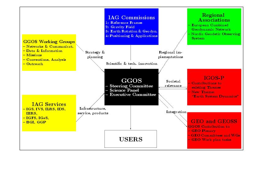
16 GGOS: The Implementation GGOS Executive Committee IAG Services IGS IGFS IVS IGeS ILRS IDS ICET GEO & GEOSS GGOS Contribution to - GEO Plenary - GEO Committees and WGs - GEO Work plan tasks M. Rothacher, H.-P. Plag, R. Neilan C. Ma, M. Pearlman, S. Zerbini IERS BGI Secretariat IGOS-P IAG Commissions - Themes 1: Reference Frames 2: Gravity Field 3: Earth Rotation & Geodynamics 4: Positioning & Applications GGOS Science Panel GGOS Steering Committee 10 Members All relevant fields 36 Members GGOS Working Groups Ground Networks & Communications Satellite Missions User Linkage & Outreach M. Pearlman S. Bettadpur B. Bye Data & Information Systems Conventions / Modelling / Analysis B. Richter / C. Noll H. Drewes
17 GGOS and IGOS-P Themes The Geohazards Theme: Plate tectonics, pre-, co- and post-seismic strain, processes associated with volcanos, early warning for tsunamies, subsidence, precarious rocks, landslides, and local and regional predictions of sea level rise are examples of topics that link this theme to geodetic observations. The Ocean Theme: Ocean circulation, sea level rise, postglacial rebound, dynamic sea surface topography, are linked to the three geodetic quantities, both for the monitoring and studies of the ocean's variability as well as model validation. Water Cycle Theme: The geodetic observations provide a unique tool to monitor the global to local scale movememts of water throught the Earth system and the theme is strongly linked to geodesy. The Coast Observation Theme: Sea level and ocean circulation are relevant parameters influencing the dynamic processes in the coastal zone and linking the theme to geodesy. The Cryosphere Theme: Ice mass balance, glacially induced deformations, and induced sea level variations all are important parameters, that are directly observed by the geodetic observation techniques. The Land Theme: Changes in the elevation are directly observed by geodetic techniques.
18 GGOS and IGOS-P Themes Example: Sea Level and Ice Sheets Trends Relevant for: Ocean Theme, Coast Observation Theme, Water Cycle Theme, Cryosphere Theme


19 Tide Gauges GGOS and IGOS-P Themes GNSS Reflections Satellite Altimetry Laser ht t p://icesat.gsfc.nasa.gov Radar Court esy NASA/JPL-Calt ech Zufada & Zavorot ny (2004)
20 GGOS and IGOS-P Themes GGOS Contribution: Terrestrial and celestial reference frames Precise positioning Monuments on ground Tide gauges Satellites in space Radar and laser altimeters Gravity measurements Time variable Ocean-bottom pressure Static Mean ocean circulation GNSS reflections

21 GGOS and IGOS-P Themes Uncertainties in relation between reference frame origin and Center of Mass of Earth System (CM): Uncertainty of 2 mm/yr affects: global sea level by 0.4 mm/yr ice sheet trends by 1.5 mm/yr local sea level by 2 mm/yr mm/yr Kierulf and Plag, 2005
.")
22 Plag, 2006 GGOS and IGOS-P Themes Local Sea Level (LSL) Link between LSL and global sea level complex (Water cycle and Ocean themes). LSL depends on local, regional and global processes (Coastal Theme). Satellite altimetry measures sea surface height, not LSL: geodesy provides the link.
23 GGOS and IGOS-P Themes Water Cycle and Geodesy Gravity field variability measurements Degree-1 mass transport EOP as a constraint Ice sheets Sea Level & Circulation Radio Occultations Surface loading (geometry)
24 GGOS and IGOS-P Themes Water Cycle and Geodesy Areas: Ground Water Storage Changes Climate/Weather Models Snow-melt & run-off forecasts Current deficiencies are: Latency (GGOS can solve this) Data Gaps (GGOS can solve this) Resolution (GGOS cannot solve this alone)
25 GGOS and IGOS-P Themes Geodesy contribution to IGWCO Theme: Long-term changes in ground-water storage change Even if geodetic spatial scales are too large, there is no other unified, practical & global measurement set available within hydrology Weather model boundary conditions Large-scale P-E estimates Snow Cover Changes These contributions are of twofold importance: Monitoring of the state of water cycle Assimilating into models for calibration of models
26 Conclusions Geodetic techniques are indispensable for Earth observation systems GGOS coordinates global networks for monitoring displacements, gravity variations and Earth's rotation variations GGOS provides the backbone for Earth observations: ITRF GGOS provides observations related to the dynamics of the Earth Users are (still) not fully aware of the potential of geodetic observations
The Global Geodetic Observing System (GGOS) of the International Association of Geodesy (IAG)
 of the International Association of Geodesy (IAG)") The Global Geodetic Observing System (GGOS) of the International Association of Geodesy (IAG) Hermann Drewes Representative of the International Union of Geodesy and Geophysics (IUGG) to the Cartographic
The Global Geodetic Observing System (GGOS) of the International Association of Geodesy (IAG) Hermann Drewes Representative of the International Union of Geodesy and Geophysics (IUGG) to the Cartographic
GG S Global Geodetic Observing System (GGOS): Status and Future. Markus Rothacher, Ruth Neilan, Hans-Peter Plag
: Status and Future. Markus Rothacher, Ruth Neilan, Hans-Peter Plag") 2020 Global Geodetic Observing System (GGOS): Status and Future Markus Rothacher, Ruth Neilan, Hans-Peter Plag GeoForschungsZentrum Potsdam (GFZ) Jet Propulsion Laboratory (JPL) University of Nevada, Reno
2020 Global Geodetic Observing System (GGOS): Status and Future Markus Rothacher, Ruth Neilan, Hans-Peter Plag GeoForschungsZentrum Potsdam (GFZ) Jet Propulsion Laboratory (JPL) University of Nevada, Reno
Linking the Global Geodetic Observing System (GGOS) (IGOS-P) through the Theme Earth System Dynamics. with the Integrated Global Observing Strategy
 (IGOS-P) through the Theme Earth System Dynamics. with the Integrated Global Observing Strategy") Linking the Global Geodetic Observing System (GGOS) to the Integrated Global Observing Strategy Partnership (IGOS-P) through the Theme Earth System Dynamics H.-P. Plag, Nevada Bureau of Mines and Geology
Linking the Global Geodetic Observing System (GGOS) to the Integrated Global Observing Strategy Partnership (IGOS-P) through the Theme Earth System Dynamics H.-P. Plag, Nevada Bureau of Mines and Geology
GGOS The Global Geodetic Observing System of the International Association of Geodesy
 GGOS The Global Geodetic Observing System of the International Association of Geodesy Presented at the FIG Working Week 2017, May 29 - June 2, 2017 in Helsinki, Finland Hansjörg Kutterer BKG, Germany Content
Physical Dynamics of the Coastal Zone in the Mediterranean on Annual to Decadal Scales
 Physical Dynamics of the Coastal Zone in the Mediterranean on Annual to Decadal Scales Hans-Peter Plag Nevada Bureau of Mines and Geology and Seismological Laboratory University of Nevada, Reno, Nevada,
El proyecto Sistema de Observación Geodésico Global [Global Geodetic Observing System (GGOS)] de la Asociación Internacional de Geodesia (IAG)
![El proyecto Sistema de Observación Geodésico Global [Global Geodetic Observing System (GGOS)] de la Asociación Internacional de Geodesia (IAG)](/thumbs/79/79010389.jpg "El proyecto Sistema de Observación Geodésico Global [Global Geodetic Observing System (GGOS)] de la Asociación Internacional de Geodesia (IAG)") El proyecto Sistema de Observación Geodésico Global [Global Geodetic Observing System (GGOS)] de la Asociación Internacional de Geodesia (IAG) Hermann Drewes Deutsches Geodätisches Forschungsinstitut (DGFI)
El proyecto Sistema de Observación Geodésico Global [Global Geodetic Observing System (GGOS)] de la Asociación Internacional de Geodesia (IAG) Hermann Drewes Deutsches Geodätisches Forschungsinstitut (DGFI)
GG S. Internal Vision of GGOS. Markus Rothacher. GFZ Potsdam
 Internal Vision of GGOS Markus Rothacher GFZ Potsdam GGOS Retreat DGFI in Munich February 15-16, 2006 Contents Motivation Four Levels of Products of the IAG Services: First Level: Raw Data Collection Second
Geodetic Observing Systems: tools in observing the Glacial Isostatic Adjustment. Markku Poutanen Finnish Geodetic Institute
 Geodetic Observing Systems: tools in observing the Glacial Isostatic Adjustment Markku Poutanen Finnish Geodetic Institute Glacial Isostatic Adjustment Land uplift is just one consequence of the physical
GGOS The Global Geodetic Observing System of the International Association of Geodesy (IAG)
") GGOS The Global Geodetic Observing System of the International Association of Geodesy (IAG) Hansjörg KUTTERER, Germany Key words: Geodetic Reference Frames, Global Geodetic Observing System, International
GGOS The Global Geodetic Observing System of the International Association of Geodesy (IAG) Hansjörg KUTTERER, Germany Key words: Geodetic Reference Frames, Global Geodetic Observing System, International
New satellite mission for improving the Terrestrial Reference Frame: means and impacts
 Fourth Swarm science meeting and geodetic missions workshop ESA, 20-24 March 2017, Banff, Alberta, Canada New satellite mission for improving the Terrestrial Reference Frame: means and impacts Richard
Global & National Geodesy, GNSS Surveying & CORS Infrastructure
 Global & National Geodesy, GNSS Surveying & CORS Infrastructure Chris Rizos School of Surveying & Spatial Information Systems University of New South Wales, Sydney, Australia President-elect, International
Torsten Mayer-Gürr Institute of Geodesy, NAWI Graz Technische Universität Graz
 GGOS and Reference Systems Introduction 2015-10-12 Torsten Mayer-Gürr Institute of Geodesy, NAWI Graz Technische Universität Graz Torsten Mayer-Gürr 1 Course and exam Lecture Monday 14:00 16:00, A111 (ST01044)
Update on the International Terrestrial Reference Frame (ITRF) : ITRF2014. Zuheir Altamimi
 : ITRF2014. Zuheir Altamimi") Update on the International Terrestrial Reference Frame (ITRF) : ITRF2014 Zuheir Altamimi Head of the IERS ITRF Product Center IAG Vice President IGN, France E-mail: zuheir.altamimi@ign.fr Key Points Introduction:
Update on the International Terrestrial Reference Frame (ITRF) : ITRF2014 Zuheir Altamimi Head of the IERS ITRF Product Center IAG Vice President IGN, France E-mail: zuheir.altamimi@ign.fr Key Points Introduction:
Dependences in the pillar Earth s gravity field of
 Reports on Geodesy, vol. 92, no. 1, 2012 Dependences in the pillar Earth s gravity field of GGOS - description using UML notation Małgorzata Paśnicka 1, Karolina Szafranek 2, Agnieszka Zwirowicz Rutkowska
GGOS, ECGN and NGOS: Global and regional geodetic observing systems. Markku Poutanen Finish Geodetic Institute
 GGOS, ECGN and NGOS: Global and regional geodetic observing systems Markku Poutanen Finish Geodetic Institute Contents GGOS, ECGN, NGOS Why? How? Future? (geodesy) GGOS Structure GGOS Structure European
Preface. About this book. Background
 Foreword The Global Geodetic Observing System (GGOS) has been established by the International Association of Geodesy (IAG) in order to integrate the three fundamental areas of geodesy, so as to monitor
GGOS INFORMATION MODELS: ANALYSIS OF INTERRELATIONS BETWEEN OBSERVATION TECHNIQUES AND THE EARTH GRAVITY FIELD
 GGOS INFORMATION MODELS: ANALYSIS OF INTERRELATIONS BETWEEN OBSERVATION TECHNIQUES AND THE EARTH GRAVITY FIELD Wojciech Pachelski 1) Małgorzata Paśnicka-Pawłowska 2) Karolina Szafranek 3) Agnieszka Zwirowicz
The Interactions between IGS and GGOS
 The Interactions between IGS and GGOS Markus Rothacher Institute of Geodesy and Photogrammetry (IGP) ETH Zurich, Switzerland 2012 IGS Workshop July 23-27, 2012, Olsztyn, Poland Overview GGOS Vision, Mission
A Unique Reference Frame: Basis of the Global Geodetic Observing System (GGOS) for Geodynamics and Global Change
 for Geodynamics and Global Change") SRTM (InSAR) A Unique Reference Frame: Basis of the Global Geodetic Observing System (GGOS) for Geodynamics and Global Change Hermann Drewes President IAG Commission 1 Reference Frames Deutsches Geodätisches
SRTM (InSAR) A Unique Reference Frame: Basis of the Global Geodetic Observing System (GGOS) for Geodynamics and Global Change Hermann Drewes President IAG Commission 1 Reference Frames Deutsches Geodätisches
From Global to National Geodetic Reference Frames: how are they connected and why are they needed?
 From Global to National Geodetic Reference Frames: how are they connected and why are they needed? Zuheir ALTAMIMI Institut National de l Information Géographique et Forestière, France Vice-President,
GGOS. Global Geodetic Observing System. Carey Noll NASA GSFC (on behalf of GGOS) WDS Forum September 11, 2016
 WDS Forum September 11, 2016") https://ntrs.nasa.gov/search.jsp?r=20160011397 2018-12-07T18:04:29+00:00Z GGOS Global Geodetic Observing System Carey Noll NASA GSFC (on behalf of GGOS) WDS Forum September 11, 2016 Global Geodetic Observing
https://ntrs.nasa.gov/search.jsp?r=20160011397 2018-12-07T18:04:29+00:00Z GGOS Global Geodetic Observing System Carey Noll NASA GSFC (on behalf of GGOS) WDS Forum September 11, 2016 Global Geodetic Observing
GGOS Bureau for Standards and Conventions
 GGOS D. Angermann (1), T. Gruber (2), J. Bouman (1), M. Gerstl (1), R. Heinkelmann (1), U. Hugentobler (2), L. Sánchez (1), P. Steigenberger (2) (1) Deutsches Geodätisches Forschungsinstitut (DGFI), München
Contributions of Geodesy to Oceanography
 Contributions of Geodesy to Oceanography B. Tapley and J. Ries Center for Space Research, The University of Texas at Austin Dynamic Planet 2005 Cairns, Australia August 22-26, 2005 August 22-26, 2005 Dynam
Strategy for the Realization of the International Height Reference System (IHRS)
") Deutsches Geodätisches Forschungsinstitut (DGFI-TUM) Technische Universität München Strategy for the Realization of the International Height Reference System (IHRS) Laura Sánchez 1, Johannes Ihde 2, Roland
Deutsches Geodätisches Forschungsinstitut (DGFI-TUM) Technische Universität München Strategy for the Realization of the International Height Reference System (IHRS) Laura Sánchez 1, Johannes Ihde 2, Roland
Surface Mass Loads from GRACE, GPS, and Earth Rotation
 Surface Mass Loads from GRACE,, and Earth Rotation R. Gross *, G. Blewitt, H.-P. Plag, P. Clarke, D. Lavallée, T. van Dam *Jet Propulsion Laboratory, California Institute of Technology, Pasadena, USA Nevada
Contributions of geodesy to monitoring natural hazards and global change
 Contributions of geodesy to monitoring natural hazards and global change Prof. Dr. Harald Schuh Director Dept. 1: Geodesy and Remote Sensing Helmholtz Centre Potsdam, GFZ German Research Centre for Geosciences
The Rotational and Gravitational Signature of Recent Great Earthquakes
 The Rotational and Gravitational Signature of Recent Great Earthquakes Richard S. Gross Jet Propulsion Laboratory California Institute of Technology Pasadena, CA 91109 8099, USA 7th IVS General Meeting
Report for 15th PCGIAP Meeting at 18th UNRCC-AP Working Group 1 Regional Geodesy
 Report for 15th PCGIAP Meeting at 18th UNRCC-AP Working Group 1 Regional Geodesy Chairman Shigeru Matsuzaka, Japan - shigeru@gsi.go.jp Vice Chairman Prof. Pengfei Cheng, China - chengpf@casm.ac.cn John
Relationships between mass redistribution, station position, geocenter, and Earth rotation: Results from IGS GNAAC analysis
 Relationships between mass redistribution, station position, geocenter, and Earth rotation: Results from IGS GNAAC analysis Geoff Blewitt Mackay School of Earth Sciences and Engineering University of Nevada,
Towards a Rigorous Combination of Space Geodetic Techniques
 Towards a Rigorous Combination of Space Geodetic Techniques Markus Rothacher Forschungseinrichtung Satellitengeodäsie, TU Munich, Germany Abstract: The with all its different components and products, ranging
Geodetic Observations and Global Reference Frame Contributions to Understanding Sea Level Rise and Variability
 Geodetic Observations and Global Reference Frame Contributions to Understanding Sea Level Rise and Variability G. Blewitt (1), Z. Altamimi (2), J. Davis (3), R. Gross (4), C. Kuo (5), F. Lemoine (6), R.Neilan
Fundamental Station Wettzell - geodetic observatory -
 Fundamental Station Wettzell - geodetic observatory - Wolfgang Schlüter Bundesamt für Kartographie und Geodäsie, Fundamental Station Wettzell Germany Radiometer Workshop, Wettzell, 10.10.06 Evolvement
Geodetic Observations and Global Reference Frame Contributions to Understanding Sea - Level Rise and Variability
 9 Geodetic Observations and Global Reference Frame Contributions to Understanding Sea - Level Rise and Variability Geoff Blewitt, Zuheir Altamimi, James Davis, Richard Gross, Chung-Yen Kuo, Frank G. Lemoine,
Towards a Consistent Conventional Treatment of Surface-Load Induced Deformations
 Towards a Consistent Conventional Treatment of Surface-Load Induced Deformations Hans-Peter Plag(1), Geoff Blewitt, Tom A. Herring (1) Nevada Bureau of Mines and Geology and Seismological Laboratory University
Lecture 2 Measurement Systems. GEOS 655 Tectonic Geodesy
 Lecture 2 Measurement Systems GEOS 655 Tectonic Geodesy VLBI and SLR VLBI Very Long Baseline Interferometry SLR Satellite Laser Ranging Very Long Baseline Interferometry VLBI Geometric Delay δg S Baseline
Roadmap Towards Future Satellite Gravity Missions in Support of Monitoring of Mass Redistribution, Global Change, and Natural Hazards
 Roadmap Towards Future Satellite Gravity Missions in Support of Monitoring of Mass Redistribution, Global Change, and Natural Hazards STRATEGIC TARGET A multi-decade, continuous series of space-based observations
SIRGAS: Basis for Geosciences, Geodata, and Navigation in Latin America
 SIRGAS: Basis for Geosciences, Geodata, and Navigation in Latin America Claudio Brunini President of SIRGAS Universidad Nacional de La Plata, Argentina María Virginia Mackern President of SIRGAS/WG-I:
REGIONAL REFERENCE FRAMES: THE IAG PERSPECTIVE
 REGIONAL REFERENCE FRAMES: THE IAG PERSPECTIVE João Agria Torres SPUIAGG IAG Sub-commission 1.3: Regional Reference Frames jatorres@iol.pt 1. About the IAG CONTENT 2. Objectives and organization of SC
The GGOS as the backbone for global observing and local monitoring: A user driven perspective
 Journal of Geodynamics 40 (2005) 479 486 The GGOS as the backbone for global observing and local monitoring: A user driven perspective H.-P. Plag Geodetic Institute, Norwegian Mapping Authority, Honefoss,
Interferometric Synthetic Aperture Radar (InSAR) and GGOS. Andrea Donnellan NASA/JPL February 21, 2007
 and GGOS. Andrea Donnellan NASA/JPL February 21, 2007") Interferometric Synthetic Aperture Radar (InSAR) and GGOS Andrea Donnellan NASA/JPL February 21, 2007 Sources for Science Objectives Fourth component of EarthScope Involvement: NSF, NASA, USGS, Universities
Interferometric Synthetic Aperture Radar (InSAR) and GGOS Andrea Donnellan NASA/JPL February 21, 2007 Sources for Science Objectives Fourth component of EarthScope Involvement: NSF, NASA, USGS, Universities
Special Bureau for Loading: Potential Role Versus Reality
 Special Bureau for Loading: Potential Role Versus Reality Hans-Peter Plag Nevada Bureau of Mines and Geology and Seismological Laboratory University of Nevada, Reno Special Bureau for Loading: Potential
Reference frames and positioning
 The APREF Project: an Improved Geodetic Infrastructure for Asia and the Pacific (4861) John Dawson (Australia), Graeme Blick (New Zealand), Manoj Deo, Guorong Hu and Gary Johnston (Australia) Reference
Low-Latency Earthquake Displacement Fields for Tsunami Early Warning and Rapid Response Support
 Low-Latency Earthquake Displacement Fields for Tsunami Early Warning and Rapid Response Support Hans-Peter Plag, Geoffrey Blewitt Nevada Bureau of Mines and Geology and Seismological Laboratory University
Global reference systems and Earth rotation
 current realizations and scientific problems Aleksander Brzeziński 1,2, Tomasz Liwosz 1, Jerzy Rogowski 1, Jan Kryński 3 1 Department of Geodesy and Geodetic Astronomy Warsaw University of Technology 2
Establishment of a Global Absolute Gravity Network
 Establishment of a Global Absolute Gravity Network H. Wilmes 1), H. Wziontek 1), R. Falk 1), J. Ihde 1), S. Bonvalot 2), R. Forsberg 3), S. Kenyon 4), L. Vitushkin 5) 1) Federal Agency for Cartography
Climate Change and Sea Level Rise: A Challenge to Science and Society
 Climate Change and Sea Level Rise: A Challenge to Science and Society Hans-Peter Plag Nevada Bureau of Mines and Geology & Seismological Laboratory University of Nevada, Reno, USA. Climate Change and Sea
The International Terrestrial Reference Frame. What is a Terrestrial Reference Frame?
 The International Terrestrial Reference Frame As early as the 15th century, Swedes noticed that rocks in their harbors were slowly rising out of the sea [Ekman, 1991]. These local observations were not
International Union of Geodesy and Geophysics. Resolutions
 International Union of Geodesy and Geophysics Resolutions ADOPTED BY THE COUNCIL AT THE XXVI GENERAL ASSEMBLY PRAGUE, CZECH REPUBLIC (22 JUNE 2 JULY 2015) 0 Page Resolution 1: Role of Ocean in Climate
A Mission to Planet Mars Gravity Field Determination
 A Mission to Planet Mars Gravity Field Determination Department for Theoretical Geodesy Graz University of Technology and Space Research Institute Austrian Academy of Sciences Gravity field CHAMP GRACE
Call for space geodetic solutions corrected for non-tidal atmospheric loading (NT-ATML) at the observation level
 at the observation level") Call for space geodetic solutions corrected for non-tidal atmospheric loading (NT-ATML) at the observation level Xavier Collilieux, Tonie van Dam, Zuheir Altamimi Outline: Context Why correcting for non-tidal
Call for space geodetic solutions corrected for non-tidal atmospheric loading (NT-ATML) at the observation level Xavier Collilieux, Tonie van Dam, Zuheir Altamimi Outline: Context Why correcting for non-tidal
INTERNATIONAL SLR SERVICE
 ARTIFICIAL SATELLITES, Vol. 46, No. 4 2011 DOI: 10.2478/v10018-012-0004-z INTERNATIONAL SLR SERVICE Stanisław Schillak Space Research Centre, Polish Academy of Sciences Astrogeodynamic Observatory, Borowiec
Earth-Oriented Space Research at TU-Delft
 Earth-Oriented Space Research at TU-Delft The contribution of DEOS to the South-East Asia: Mastering Environmental Research with Geodetic Space Techniques (SEAMERGES) project Kick-off meeting, Chulalongkorn
Summary of the 2012 Global Geophysical Fluid Center Workshop
 Summary of the 2012 Global Geophysical Fluid Center Workshop T. van Dam (Uni. Lux), J. Ray (NGS/NOAA), X. Collilieux (IGN) Introduction Review the history of the GGFC Discuss the 2012 Workshop Review recommendations
GNSS Observations & Sea Level
 with contributions from: - Marta Marcos - Alvaro Santamaria - GNSS Observations & Sea Level Guy Wöppelmann gwoppelm@univ-lr.fr Outline: 1. Introduction 2. The importance of Vertical Land Motions 3. The
Geodesy. orientation. shape. gravity field
 Geodesy noun Science of measuring the shape, orientation and gravity field of the Earth and how it changes over time. shape orientation gravity field Positioning has always been important Downstream applications
Towards an improved ILRS TRF contribution
 Towards an improved ILRS TRF contribution Erricos C. Pavlis ILRS Analysis Coordinator JCET/ & NASA Goddard IERS Workshop on Conventions 2007 20-21 Sept. 2007, Sèvres, France Overview The ILRS Network Geometry
Warkworth geodetic station as a potential GGOS core site in New Zealand
 "Launching the Next-Generation IVS Network Session 2: Correlators, Stations and Operations Centers. 7th IVS General Meeting March 5, 2012 Madrid, Spain Warkworth geodetic station as a potential GGOS core
Role and importance of the International Terrestrial Reference Frame for sustainable development
 Role and importance of the International Terrestrial Reference Frame for sustainable development This report is provided for the benefit of participants of the UNRCC-PCGIAP Informal Geodetic Consultation,
Global Geodetic Reference Frame GGRF & Implications for GNSS
 Global Geodetic Reference Frame GGRF & Implications for GNSS On behalf of Gary Johnston Chair GIAC, Ruth Neilan Vice Chair, Global Geodetic Observing System ICG-9 Prague, 10 November 2014 UN GGRF Working
EXPLORE PLATE TECTONICS & MORE THROUGH GPS DATA. Shelley Olds, UNAVCO April 12, 2018 NGSS Webinar
 EXPLORE PLATE TECTONICS & MORE THROUGH GPS DATA Shelley Olds, UNAVCO April 12, 2018 NGSS Webinar Today s Outline Central question: How do we know the tectonic plates are still moving? -- What evidence
Challenges and Perspectives for TRF and CRF Determination
 , IVS 2012 General Meeting Proceedings, p.309 313 http://ivscc.gsfc.nasa.gov/publications/gm2012/boehm.pdf Johannes Böhm 1, Zinovy Malkin 2, Sebastien Lambert 3, Chopo Ma 4 1) Vienna University of Technology
What are the social, technical, environmental and economic benefits and opportunities of accessing and sharing geodetic data?
 What are the social, technical, environmental and economic benefits and opportunities of accessing and sharing geodetic data? Graeme Blick Group Manager Positioning and Resilience Land Information New
GEOS 655 Tectonic Geodesy. Jeff Freymueller Elvey 413B, x7286
 GEOS 655 Tectonic Geodesy Jeff Freymueller jfreymueller@alaska.edu Elvey 413B, x7286 Application of Geodesy to Tectonics Uncertainties < 1 mm/y Blue: stable part of tectonic plates Red: deforming zones
Publ. Astron. Obs. Belgrade No. 91 (2012), REALIZATION OF ETRF2000 AS A NEW TERRESTRIAL REFERENCE FRAME IN REPUBLIC OF SERBIA
, REALIZATION OF ETRF2000 AS A NEW TERRESTRIAL REFERENCE FRAME IN REPUBLIC OF SERBIA") Publ. Astron. Obs. Belgrade No. 91 (2012), 199-206 Contributed paper REALIZATION OF ETRF2000 AS A NEW TERRESTRIAL REFERENCE FRAME IN REPUBLIC OF SERBIA D. BLAGOJEVIĆ and V. VASILIĆ Faculty of Civil Engineering,
Publ. Astron. Obs. Belgrade No. 91 (2012), 199-206 Contributed paper REALIZATION OF ETRF2000 AS A NEW TERRESTRIAL REFERENCE FRAME IN REPUBLIC OF SERBIA D. BLAGOJEVIĆ and V. VASILIĆ Faculty of Civil Engineering,
Consistency of Earth Rotation, Gravity, and Shape Measurements
 Consistency of Earth Rotation, Gravity, and Shape Measurements Richard S. Gross*, David A. Lavallée, Geoffrey Blewitt, and Peter J. Clarke *Jet Propulsion Laboratory, California Institute of Technology
The 2008 Local-tie Survey at the Onsala Space Observatory
 The 2008 Local-tie Survey at the Onsala Space Observatory M. Lösler, Geodetic Institute of the University of Karlsruhe (TH), DE-76128 Karlsruhe, Germany R. Haas Department of Radio and Space Science, Chalmers
CGMS Baseline In response to CGMS action/recommendation A45.01 HLPP reference: 1.1.8
 Prepared by WGIII Agenda Item: 7.1 Discussed in WGIII CGMS Baseline In response to CGMS action/recommendation A45.01 HLPP reference: 1.1.8 In CGMS-45, Working Group III agreed to hold a review of the CGMS
Principles of the Global Positioning System Lecture 18" Mathematical models in GPS" Mathematical models used in GPS"
 12.540 Principles of the Global Positioning System Lecture 18" Prof. Thomas Herring" Room 54-820A; 253-5941" tah@mit.edu" http://geoweb.mit.edu/~tah/12.540 " Mathematical models in GPS" Review assignment
A Strategic Plan for Geodesy in Sweden. Mikael Lilje Lars E. Engberg Geodesy Department Lantmäteriet Sweden
 A Strategic Plan for Geodesy in Sweden Mikael Lilje Lars E. Engberg Geodesy Department Lantmäteriet Sweden Our vision is to be able to meet Swedish society s needs for a homogeneous, sustainable geodetic
The Earth Explorer Missions - Current Status
 EOQ N 66 July 2000 meteorology earthnet remote sensing solid earth future programmes Earth Observation Quarterly The Earth Explorer Missions - Current Status G. Mégie (1) and C.J. Readings (2) (1) Institut
HY-2A Satellite User s Guide
 National Satellite Ocean Application Service 2013-5-16 Document Change Record Revision Date Changed Pages/Paragraphs Edit Description i Contents 1 Introduction to HY-2 Satellite... 1 2 HY-2 satellite data
Sea-level change: A scientific and societal challenge for the 21 st century John Church International GNSS Service Workshop, Sydney, Feb 11, 2016
 Sea-level change: A scientific and societal challenge for the 21 st century John Church International GNSS Service Workshop, Sydney, Feb 11, 2016 OCEANS AND ATMOSPHERE NATIONAL RESEARCH FLAGSHIP Our coastal
Test Computations
 158 7. Test Computations.3.2.1 -.1 -.2 Fourier index 2.8.4 -.4 -.8 Fourier index 2.2.1 -.1 -.2 Fourier index 3.8.4 -.4 -.8 Fourier index 3.2.1 -.1 -.2 -.3 Fourier index 4.8.4 -.4 -.8 Fourier index 4.2.1
GEO Geohazards Community of Practice
 GEO Geohazards Community of Practice 1) Co-Chair of GHCP With input from: Stuart Marsh, GHCP Co-Chair Francesco Gaetani, GEO Secretariat and many GHCP contributors 1) Nevada Bureau of Mines and Geology
The International Terrestrial Reference System and ETRS89: Part I : General concepts
 The International Terrestrial Reference System and ETRS89: Part I : General concepts Zuheir ALTAMIMI Laboratoire de Recherche en Géodésie Institut national de l information géographique et forestière (IGN),
Regional and global trends
 SEA LEVEL RISE Regional and global trends OCEANOBS 2009 Plenary Paper A.Cazenave D. Chambers, P. Cipollini, J. Hurell, S. Nerem, L.L. Fu, H.P. Plag, C.K. Shum, J. Willis Venice, September 2009 Global mean
Sea Level. John Church WCRP Antarctic Climate and Ecosystems CRC Centre for Australian Weather and Climate Research
 Sea Level John Church WCRP Antarctic Climate and Ecosystems CRC Centre for Australian Weather and Climate Research Sea level rose by more than 120 m since the last glacial maximum 2 Church et al., 2008
GRACE impact in geodesy and geophysics. R. Biancale (GRGS-CNES Toulouse), M. Diament (IPG Paris)
, M. Diament (IPG Paris)") GRACE impact in geodesy and geophysics R. Biancale (GRGS-CNES Toulouse), M. Diament (IPG Paris) Improvement of gravity models Since 2002 the GRACE mission has changed some goals in geodesy. It has become
GRACE impact in geodesy and geophysics R. Biancale (GRGS-CNES Toulouse), M. Diament (IPG Paris) Improvement of gravity models Since 2002 the GRACE mission has changed some goals in geodesy. It has become
Geodetics measurements within the scope of current and future perspectives of GNSS-Reflectometry and GNSS-Radio Occultation
 Geodetics measurements within the scope of current and future perspectives of GNSS-Reflectometry and GNSS-Radio Occultation Introduction The aim of this presentation is to provide an overview of the GNSS-R
Atmospheric Effects in Space Geodesy
 Atmospheric Effects in Space Geodesy Johannes Böhm 18 November 2011 @ UNESP, Presidente Prudente, Brazil The atmosphere.. is not only causing troubles in space geodesy.. but it opens up a wide field of
The International Terrestrial Reference System and ETRS89: Part II : ITRS & ETRS89 relationship
 The International Terrestrial Reference System and ETRS89: Part II : ITRS & ETRS89 relationship Zuheir ALTAMIMI Laboratoire de Recherche en Géodésie Institut national de l information géographique et forestière
Assessment of the orbit-related sea level error budget for the TOPEX/Poseidon altimetry mission
 Assessment of the orbit-related sea level error budget for the TOPEX/Poseidon altimetry mission Sergei Rudenko (1,2), Saskia Esselborn (1), Tilo Schöne (1) (1) GFZ German Research Centre for Geosciences,
CGMS Baseline. Sustained contributions to the Global Observing System. Endorsed by CGMS-46 in Bengaluru, June 2018
 CGMS Baseline Sustained contributions to the Global Observing System Best Practices for Achieving User Readiness for New Meteorological Satellites Endorsed by CGMS-46 in Bengaluru, June 2018 CGMS/DOC/18/1028862,
ITRF2014 Et la prise en compte des mouvements non linéaires
 ITRF2014 Et la prise en compte des mouvements non linéaires Zuheir Altamimi, Paul Rebischung, Laurent Métivier, Xavier Collilieux E-mail: zuheir.altamimi@ign.fr ITRF2014 Network Key Points Modelling of
Geodesy Part of the ACES Mission: GALILEO on Board the International Space Station
 Geodesy Part of the ACES Mission: GALILEO on Board the International Space Station 1 Svehla D, 2 Rothacher M, 3 Salomon C, 2 Wickert J, 2 Helm A, 2 Beyerle, G, 4 Ziebart M, 5 Dow J 1 Institute of Astronomical
3.3 Analysis Coordinator
 1. Introduction 2. Analysis of ITRF2014 post-seismic parameterization In this report we outline the activities of the Analysis Coordinator during 2015. The main activities were analysis of the ITRF2014
Status. EUREF TWG Meeting November 8 9, 2004, Praha
 ECGN was initiated by IAG Sub-Commission for Europe EUREF (SC1.3a) and IAG Sub-Commission for Europe of the International Gravity and Geoid Commission (IGGC) with relationship to Joint Research Centre
Structure of the International Association of Geodesy For the period
 Structure of the International Association of Geodesy For the period 2003-2007 Bureau President Vice President Secretary General Excecutive committee. Gerhard Beutler (Switzerland) Michael Sideris (Canada)
GOCE Research in Germany: From Sensor Analysis to Earth System Science
 GOCE Research in Germany: From Sensor Analysis to Earth System Science Reiner Rummel, Jakob Flury and Thomas Gruber Institut für Astronomische und Physikalische Geodäsie Technische Universität München
THESIS FOR THE DEGREE OF LICENTIATE OF ENGINEERING. Geodetic analysis for the Very Long Baseline Interferometry Global Observing System NIKO KAREINEN
 THESIS FOR THE DEGREE OF LICENTIATE OF ENGINEERING Geodetic analysis for the Very Long Baseline Interferometry Global Observing System NIKO KAREINEN Department of Earth and Space Sciences CHALMERS UNIVERSITY
Meteorological instruments and observations methods: a key component of the Global Earth Observing System of Systems (GEOSS)
") GLOBAL OBSERVING SYSTEMS Instruments and Methods of Observation Programme Meteorological instruments and observations methods: a key component of the Global Earth Observing System of Systems (GEOSS) Dr.
GLOBAL OBSERVING SYSTEMS Instruments and Methods of Observation Programme Meteorological instruments and observations methods: a key component of the Global Earth Observing System of Systems (GEOSS) Dr.
Time-variable gravity from SLR and DORIS tracking
 Time-variable gravity from SLR and DORIS tracking Frank G. Lemoine 1, Steven M. Klosko 2, Christopher M. Cox 3, Thomas J. Johnson 4 1. Planetary Geodynamics Laboratory, NASA Goddard Space Flight Center,
Next Generation Australian Datum. Permanent Committee on Geodesy, ICSM
 Next Generation Australian Datum Permanent Committee on Geodesy, ICSM 2 Presentation: Next Generation Australian Datum Trends in the geospatial sector The Geocentric Datum of Australia 1994 (GDA94) Progress
Frequent epoch reference frames instead of instant station positions and constant velocities
 Deutsches Geodätisches Forschungsinstitut Technische Universität München (DGFI-TUM) Frequent epoch reference frames instead of instant station positions and constant velocities Hermann Drewes Deutsches
GEORED Project: GNSS Geodesy Network for Geodynamics Research in Colombia, South America. Héctor Mora-Páez
 GEORED Project: GNSS Geodesy Network for Geodynamics Research in Colombia, South America. Héctor Mora-Páez Colombian Geological Survey UNAVCO SCIENCE MEETING Feb 27 March 1, 2012 Boulder, CO, TECTONIC
Understanding Earth Rotation Part 2: Physical Foundations and Interpretation
 Understanding Earth Rotation Part 2: Physical Foundations and Interpretation Prof. Dr. Florian Seitz Technische Universität München (TUM) Deutsches Geodätisches Forschungsinstitut (DGFI) Munich, Germany
CEOS Overview and JAXA Plans for Water Cycle Observation
 CEOS Overview and JAXA Plans for Water Cycle Observation Asian Water Cycle Symposium November 2-4, 2005 Tokyo, Japan Chu Ishida Japan Aerospace Exploration Agency (JAXA) Contents 1. CEOS overview 2. CEOS
Subject Classification
 Istituto Nazionale di Geofisica e Vulcanologia earth-prints home page roma library bologna library catania library milano library napoli library palerm Subject Classification Earth-prints organize its
DETERMINATION OF THE STATION COORDINATES FOR QUALITY CONTROL OF THE SATELLITE LASER RANGING DATA S.
 DETERMINATION OF THE STATION COORDINATES FOR QUALITY CONTROL OF THE SATELLITE LASER RANGING DATA S. Schillak Space Research Centre of the Polish Academy of Sciences. Astrogeodynamic Observatory, Borowiec
Application of Satellite Laser Ranging for Long- Wavelength Gravity Field Determination
 Application of Satellite Laser Ranging for Long- Wavelength Gravity Field Determination J. C. Ries Center for Space Research The University of Texas at Austin Low Degree Gravity Variations from SLR GRACE